
Notices to Mariners
February 27, 2026

Safety First, Service Always
Monthly Western Edition
CONTENTS
| Section 1 | General and Safety Information |
| Section 1A | Temporary and Preliminary Notices |
| Section 2 | Chart Corrections |
| Section 3 | Radio Aids to Marine Navigation Corrections |
| Section 4 | Canadian Sailing Directions Corrections |
| Section 5 | List of Lights, Buoys and Fog Signals Corrections |
Notices to Mariners – Monthly Western Edition
Edition No. 02/2026
Aussi disponible en français :
Avis aux navigateurs – Édition mensuelle de l’Ouest
Édition n° 02/2026
Published under the Authority of:
Canadian Coast Guard Programs
Aids to Navigation and Waterways
Montreal, QC H2Y 2E7
For more information, contact DFO.Notmar-Notmar.MPO@dfo-mpo.gc.ca.
© His Majesty the King in Right of Canada,
as represented by the Canadian Coast Guard, 2026.
Cat. No. Fs152-9E-PDF (Electronic PDF, English)
ISSN 2817-0253
Cat. No. Fs152-9F-PDF (Electronic PDF, French)
ISSN 2817-0261

Explanatory Notes – Notices to Mariners (NOTMAR)
Geographical positions refer directly to the graduations of the largest scale Canadian Hydrographic Service chart (unless otherwise indicated).
Bearings refer to the true compass and are measured clockwise from 000° (North) clockwise to 359°; those relating to lights are from seaward.
Visibility of lights is that in clear weather.
Depths - The units used for soundings (metres, fathoms or feet) are stated in the title of each chart.
Elevations are normally given above Higher High Water, Large Tide (unless otherwise indicated).
Distances may be calculated as follows:
1 nautical mile = 1,852 metres (6,076.1 feet)
1 statute mile = 1,609.3 metres (5,280 feet)
1 metre = 3.28 feet
Temporary and Preliminary Notices to Mariners – Section 1A of Notices to Mariners
These notices are indicated by a (T) or a (P), respectively. Please note that nautical charts are not amended by the Canadian Hydrographic Service for temporary (T) and preliminary (P) notices. It is recommended that mariners chart these corrections in pencil. For the list of charts affected by (T) & (P) notices, please refer to the current Notices to Mariners - Monthly Summary of Temporary and Preliminary Notices publication.
Suggestions and Corrections Form
This form is specifically for suggestions and corrections to Notices to Mariners publications. It is available online and also in fillable PDF format included with the monthly publication ZIP file.
To submit comments and suggestions on possible improvements to the various publications and services: DFO.Notmar-Notmar.MPO@dfo-mpo.gc.ca.
To report chart discrepancies and/or corrections to the Canadian Sailing Directions booklets: Fill out the Marine Information Reporting Form and/or email chsinfo@dfo-mpo.gc.ca.
To report emergencies or navigational hazards: Contact your nearest MCTS centre
- VHF channel 16 (156.8 MHz)
- MF/HF frequency 2182 kHz/4125 kHz (where available)
- ∗16 on a cellphone (where available)
NOTMAR Website – Monthly Editions, Chart Corrections and Chart Patches
The NOTMAR website allows users to access the monthly publications,
chart corrections, and chart patches.
Users can subscribe for free to the email notification service
to receive notifications when charts of interest are updated, including their patches, as well as when a new Monthly Edition of Notices to Mariners is published.
In addition, the monthly publication and related
files to download, such as chart patches, can be obtained
all together through the download of a single ZIP file.
Explanatory Notes – Canadian Hydrographic Service (CHS)
Chart Corrections – Section 2 of Notices to Mariners
Corrections to nautical charts will be listed in numerical order by chart number. Each chart correction listed applies only to that particular chart. Related charts, if any, will have their own specific correction listed separately.
Users should also refer to CHS Chart 1: Symbols, Abbreviations and Terms for additional information pertaining to the correction of charts.
The illustration below describes the elements that will comprise a typical Section 2 chart correction:

The last correction number is identified with the LNM/D or Last Notice to Mariners Number / Date.
Mariners are advised that only the most critical changes that directly affect safety to navigation are issued in “Section 2 – Chart Corrections.” This limitation is required to ensure that charts remain as clear and easy to read as possible. As a result, mariners may see minor discrepancies of a non-critical nature between information in official publications. For example, a small change in the nominal range or focal height of a light may not result in the production of a chart correction in Notices to Mariners, but may result in a correction in the List of Lights, Buoys and Fog Signals publication.
Note: In the case of a discrepancy between information provided on CHS charts relating to aids to navigation, and the List of Lights, Buoys and Fog Signals publication, the latter shall be deemed as containing the most up-to-date information.
Explanatory Notes – Marine Communications and Traffic Services (MCTS)
Navigational Warnings / Notices to Shipping
The Canadian Coast Guard (CCG) is implementing a number of changes to the aids to navigation system in Canada.
These changes are advertised as Navigational Warnings, formerly called Notices to ShippingFootnote 1, that are broadcast by the CCG, and are then followed up with Notices to Mariners, then charts are updated by hand correction, reprints or new editions.
Mariners are advised that all relevant Navigational Warnings (NAVWARN) should be kept until superseded by Notices to Mariners or through revised charts issued by the Canadian Hydrographic Service (CHS).
NAVWARN are accessible on the applicable regional page on the CCG Navigational Warnings.
CHS is reviewing the impact of these changes with CCG and together are preparing an action plan on the issuing of chart revisions.
For further information, contact your regional NAVWARN Issuing Desk.
Western Region
Prince Rupert MCTS Centre
“P” Series NAVWARN
Canadian Coast Guard
Bag 4444
Prince Rupert, BC V8J 4K2
Telephone: 250-627-3070
Email: NAVWARN.MCTSPrinceRupert@innav.gc.ca
Arctic Region
* Iqaluit MCTS Centre
Operational from approximately mid-May until late December.
“A” Series NAVWARN
Canadian Coast Guard
P.O. Box 189
Iqaluit, NU X0A 0H0
Telephone: 867-979-5269
Facsimile: 867-979-4264
Email: NAVWARN.MCTSIqaluit@innav.gc.ca
* Service available in English and French.
Index
Numerical Index of Canadian Charts Affected
This numerical index lists all nautical charts mentioned in this monthly edition of Notices to Mariners. Only charts appearing in Section 2 of this publication require a chart correction. The appearance of charts in all other sections, particularly those related to the correction of other nautical publications, is included here for reference.
| 3412 | 3479 | 3686 | 3959 |
| 3419 | 3490 | 3868 | 3976 |
| 3441 | 3605 | 3912 | 3983 |
| 3447 | 3673 | 3921 | 6258 |
| 3456 | 3679 | 3955 | 6417 |
| 3462 | 3681 | 3957 | 6424 |
| 3463 | 3685 | 3958 | 6425 |
SECTION 1 - GENERAL AND SAFETY INFORMATION
*505/23Canadian Hydrographic Service – Magnetic Declination Calculations
(Recurrent publication of notice *505/23, originally published in the Notices to Mariners – Monthly Western Edition 05/2023 publication.)
Mariners are advised that CHS has adopted the harmonized World Magnetic Model (WMM), as found on the NCEI/NOAA website. Old compass rose declination information on CHS navigational products can be updated using the Magnetic Declination Estimated Value website. While the differences in the model declinations are small each year, they can become more significant over a large period of time.
*1207/23Canadian Hydrographic Service – Inappropriate Geographical Names Review Process
(Recurrent publication of notice *1207/23, originally published in the Notices to Mariners – Monthly Western Edition 12/2023 publication.)
The records of the Canadian Hydrographic Service could contain geographical names that may be considered inappropriate, offensive and derogatory. Geographical naming authorities are in the process of addressing many offensive place names, the review process is underway. For more information, about inappropriate geographical names, please see the following announcement.
*208/24West Coast Haida Gwaii – Voluntary Protection Zone for Shipping
(Recurrent publication of notice *208/24, originally published in the Notices to Mariners – Monthly Western Edition 02/2024 publication.)
Reference: Notice *1105/21 is cancelled.
Voluntary Protection Zone for Shipping, western shore
of Haida Gwaii
(formerly Queen Charlotte Islands)
Haida Gwaii’s remote location, rugged coastline, variable sea and weather conditions, and rich ecological and cultural heritage make it vulnerable to the potential for pollution from shipping breakdowns and accidents. Increasing the distance vessels travel offshore can increase the amount of time available to address propulsion, steering or other issues, and the likelihood of a towing vessel being able to respond to a vessel in distress or drifting. This in turn reduces the risk of grounding and oil spills.
A Voluntary Protection Zone for Shipping on the western shore of Haida Gwaii is currently in effect. In the Voluntary Protection Zone, commercial vessels of 500 gross tonnage or greater are requested to observe a minimum distance of 50 nautical miles from the western shore of Haida Gwaii with the following exemptions:
Exemptions from requested 50 nm distance:
•Cruise vessels, which are asked to observe a minimum
12 nm distance from shore;
•Vessels transiting from Alaska to British Columbia or
Washington State, or vice versa, through the Voluntary
Protection Zone are asked to observe a distance of at least
25 nm from shore
•No minimum distance is requested for tugs and barges
(including pushing and towing alongside) or vessels engaged
in commercial fishing.
•Vessels to which this bulletin applies are not required to observe requested minimum distances if doing so may compromise navigational, vessel, passenger or cargo safety.
The Voluntary Protection Zone for Shipping coordinates are:
|
54⁰ 15.436' N |
133⁰ 04.788' W |
|
54⁰ 17.572' N |
134⁰ 02.484' W |
|
54⁰ 13.614' N |
134⁰ 19.427' W |
|
54⁰ 11.786' N |
134⁰ 30.841' W |
|
53⁰ 44.036' N |
134⁰ 32.677' W |
|
53⁰ 11.118' N |
134⁰ 16.412' W |
|
52⁰ 18.483' N |
133⁰ 20.917' W |
|
51⁰ 24.590' N |
132⁰ 04.081' W |
|
51⁰ 56.158' N |
131⁰ 01.830' W |
Vessels are requested to adhere to these distances on a voluntary basis and only when it does not jeopardize the safety of navigation, the vessel, the persons onboard, and the cargo.

*1105/24Transport Canada – British Columbia North Coast Waterway Management Guidelines
(Recurrent publication of notice *1105/24, originally published in the Notices to Mariners – Monthly Western Edition 11/2024 publication.)
Reference: Notice *1004/23 is cancelled.
The North Coast Waterway Management Guidelines are voluntary guidelines that aim to improve safety on the water by reducing conflicts between First Nations’ marine use activities, such as fishing and shoreline harvesting, and commercial vessels on the shipping route between Kitimat and Browning Entrance. The guidelines came into effect on September 1, 2022, and will be reviewed from time to time.
The guidelines apply to all vessels navigating on the route between Kitimat and Browning Entrance, on the north coast of British Columbia. This area includes:
|
•Douglas Channel |
•Otter Channel |
|
•Wright Sound |
•Nepean Sound, and |
|
•Lewis Passage |
•Principe Channel |
The
complete guidelines document is available at
British Columbia North Coast Waterway Management
Guidelines.
Nothing in these guidelines replaces or changes how we apply
any Canadian or international laws or regulations, including
the Collision Regulations. Furthermore, nothing in these
guidelines prevents or limits the master or pilot of a ship
from making any decisions to protect the vessel, the crew, or
the marine environment.

The guidelines include information for:
•all vessels that covers:
- inshore safety zones
- routing measures
- speed reductions
- guidelines for meeting and passing
- a special operating area in Wright Sound, and
- guidelines in case of a mechanical or electrical breakdown
•large commercial ships, including bulk carriers,
general cargo vessels, liquid bulk vessels, and passenger
vessels
•tugs and barges, and
•vessels operating in First Nations Areas of Concern where you must pay special attention to make sure local community users can transit and use the area safely.
*201/26Canadian Hydrographic Service – Electronic Navigational Charts
|
S-57 & S-101 ENC Number |
Chart Title |
Published |
|
|
New Charts |
|||
|
CA546RFA (Edn 1.000) |
Louisbourg Harbour |
2026-01-16 |
|
|
CA547RFA (Edn 1.000) |
Louisbourg Harbour |
2026-01-16 |
|
|
CA571258 (Edn 1.000) |
Bamfield Inlet |
2026-02-13 |
|
|
New Editions |
|||
|
101CA00P454N0735W (Edn 4.000) |
101CA00P454N0735W |
2026-01-30 |
|
|
101CA00P454N0736W (Edn 4.000) |
101CA00P454N0736W |
2026-01-30 |
|
|
101CA00P454N0737W (Edn 4.000) |
101CA00P454N0737W |
2026-01-30 |
|
|
101CA00P454N0738W (Edn 6.000) |
101CA00P454N0738W |
2026-01-30 |
|
|
101CA00P455N0735W (Edn 5.000) |
101CA00P455N0735W |
2026-01-30 |
|
|
101CA00P455N0736W (Edn 4.000) |
101CA00P455N0736W |
2026-01-30 |
|
|
101CA00P456N0735W (Edn 4.000) |
101CA00P456N0735W |
2026-01-30 |
|
|
101CA00P456N0736W (Edn 3.000) |
101CA00P456N0736W |
2026-01-30 |
|
|
101CA00P457N0734W (Edn 3.000) |
101CA00P457N0734W |
2026-01-30 |
|
|
101CA00P457N0735W (Edn 3.000) |
101CA00P457N0735W |
2026-01-30 |
|
|
101CA00P457N0736W (Edn 3.000) |
101CA00P457N0736W |
2026-01-30 |
|
|
101CA00P458N0733W (Edn 3.000) |
101CA00P458N0733W |
2026-01-17 |
|
|
101CA00P458N0734W (Edn 3.000) |
101CA00P458N0734W |
2026-01-30 |
|
|
101CA00P459N0732W (Edn 3.000) |
101CA00P459N0732W |
2026-01-30 |
|
|
101CA00P460N0731W (Edn 3.000) |
101CA00P460N0731W |
2026-01-30 |
|
|
101CA00P460N0732W (Edn 4.000) |
101CA00P460N0732W |
2026-01-30 |
|
|
101CA00P462N0727W (Edn 3.000) |
101CA00P462N0727W |
2026-01-30 |
|
|
101CA00P463N0724W (Edn 3.000) |
101CA00P463N0724W |
2026-01-30 |
|
|
101CA00P463N0725W (Edn 3.000) |
101CA00P463N0725W |
2026-01-30 |
|
|
101CA00P463N0726W (Edn 3.000) |
101CA00P463N0726W |
2026-01-30 |
|
|
101CA00P464N0724W (Edn 3.000) |
101CA00P464N0724W |
2026-01-30 |
|
|
101CA00P465N0722W (Edn 3.000) |
101CA00P465N0722W |
2026-01-30 |
|
|
101CA00P466N0716W (Edn 3.000) |
101CA00P466N0716W |
2026-01-30 |
|
|
101CA00P466N0719W (Edn 3.000) |
101CA00P466N0719W |
2026-01-30 |
|
|
101CA00P467N0712W (Edn 3.000) |
101CA00P467N0712W |
2026-01-30 |
|
|
101CA00P467N0713W (Edn 4.000) |
101CA00P467N0713W |
2026-01-30 |
|
|
101CA00P467N0714W (Edn 3.000) |
101CA00P467N0714W |
2026-01-30 |
|
|
101CA00P468N0712W (Edn 3.000) |
101CA00P468N0712W |
2026-01-30 |
|
|
101CA00T450N0740W (Edn 4.000) |
101CA00T450N0740W |
2026-01-31 |
|
|
101CA00T460N0710W (Edn 5.000) |
101CA00T460N0710W |
2026-01-30 |
|
|
101CA00T460N0720W (Edn 6.000) |
101CA00T460N0720W |
2026-01-31 |
|
|
101CA00T460N0720W (Edn 7.000) |
101CA00T460N0720W |
2026-01-30 |
|
|
101CA00T460N0730W (Edn 6.000) |
101CA00T460N0730W |
2026-01-30 |
|
|
101CA00T460N0740W |
2026-01-31 |
||
|
101CA00T460N0740W (Edn 6.000) |
101CA00T460N0740W |
2026-01-30 |
|
|
101CA00T470N0710W (Edn 6.000) |
101CA00T470N0710W |
2026-01-17 |
|
|
CA217P1A (Edn 3.000) |
CA217P1A |
2026-01-23 |
|
|
CA217Q8A (Edn 2.000) |
CA217Q8A |
2026-01-23 |
|
|
CA217RFA (Edn 2.000) |
CA217RFA |
2026-01-23 |
|
|
CA217SNA (Edn 2.000) |
CA217SNA |
2026-01-23 |
|
|
CA217TVA (Edn 2.000) |
CA217TVA |
2026-01-23 |
|
|
CA217V3A (Edn 2.000) |
CA217V3A |
2026-01-23 |
|
|
CA217WAA (Edn 2.000) |
CA217WAA |
2026-01-23 |
|
|
CA22EQ8A (Edn 2.000) |
CA22EQ8A |
2026-01-23 |
|
|
CA22ERFA (Edn 2.000) |
CA22ERFA |
2026-01-23 |
|
|
CA22ESNA (Edn 2.000) |
CA22ESNA |
2026-01-23 |
|
|
CA22ETVA (Edn 2.000) |
CA22ETVA |
2026-01-23 |
|
|
CA22EV3A (Edn 2.000) |
CA22EV3A |
2026-01-23 |
|
|
CA22EWAA (Edn 2.000) |
CA22EWAA |
2026-01-23 |
|
|
CA23MP1B (Edn 2.000) |
CA23MP1B |
2026-01-23 |
|
|
CA23MQ8B (Edn 2.000) |
CA23MQ8B |
2026-01-23 |
|
|
CA23MRFA (Edn 2.000) |
CA23MRFA |
2026-01-16 |
|
|
CA23MSNA (Edn 2.000) |
CA23MSNA |
2026-01-23 |
|
|
CA24UMTA (Edn 2.000) |
Overview4800N07200W |
2026-02-20 |
|
|
CA24UQ8A (Edn 3.000) |
Overview4800N06400W |
2026-02-20 |
|
|
CA24URFA (Edn 2.000) |
Overview4800N06000W |
2026-02-20 |
|
|
CA24UV3A (Edn 2.000) |
CA24UV3A |
2026-01-23 |
|
|
CA24UWAA (Edn 2.000) |
CA24UWAA |
2026-01-23 |
|
|
CA24UXHA (Edn 2.000) |
CA24UXHA |
2026-01-23 |
|
|
CA24UYQA (Edn 2.000) |
CA24UYQA |
2026-01-23 |
|
|
CA262RFA (Edn 2.000) |
CA262RFA |
2026-01-23 |
|
|
CA262SNA (Edn 4.000) |
CA262SNA |
2026-02-20 |
|
|
CA262TVA (Edn 2.000) |
CA262TVA |
2026-01-23 |
|
|
CA262V3A (Edn 2.000) |
CA262V3A |
2026-01-23 |
|
|
CA262WAA (Edn 2.000) |
CA262WAA |
2026-01-23 |
|
|
CA262XHA (Edn 2.000) |
CA262XHA |
2026-01-23 |
|
|
CA262YQA (Edn 2.000) |
CA262YQA |
2026-01-23 |
|
|
CA279RFA (Edn 2.000) |
CA279RFA |
2026-01-23 |
|
|
CA279SNA (Edn 2.000) |
CA279SNA |
2026-01-23 |
|
|
CA279TVA (Edn 2.000) |
CA279TVA |
2026-01-23 |
|
|
CA279V3A (Edn 2.000) |
CA279V3A |
2026-01-23 |
|
|
CA279WAA (Edn 2.000) |
CA279WAA |
2026-01-23 |
|
|
CA279XHA (Edn 2.000) |
CA279XHA |
2026-01-23 |
|
|
CA279YQA |
2026-01-23 |
||
|
CA43MMHA (Edn 3.000) |
Transit4400N07300W |
2026-02-20 |
|
|
CA43MPXA (Edn 2.000) |
CA43MPXA |
2026-01-23 |
|
|
CA43MPXB (Edn 2.000) |
CA43MPXB |
2026-01-23 |
|
|
CA43MQ8A (Edn 2.000) |
CA43MQ8A |
2026-01-23 |
|
|
CA43MQ8B (Edn 2.000) |
CA43MQ8B |
2026-01-23 |
|
|
CA43MR5A (Edn 2.000) |
CA43MR5A |
2026-01-16 |
|
|
CA43MRFA (Edn 2.000) |
CA43MRFA |
2026-01-16 |
|
|
CA43MRRA (Edn 2.000) |
CA43MRRA |
2026-01-16 |
|
|
CA43XMHA (Edn 3.000) |
Transit4500N07300W |
2026-02-20 |
|
|
CA43XQ8A (Edn 2.000) |
CA43XQ8A |
2026-01-16 |
|
|
CA43XQJA (Edn 2.000) |
CA43XQJA |
2026-01-16 |
|
|
CA448N4A (Edn 5.000) |
Transit4600N07100W |
2026-02-13 |
|
|
CA471014 (Edn 5.000) |
Hippa Island, Seal Inlet, Tartu Inlet, Masset Inlet |
2026-02-13 |
|
|
CA471017 (Edn 2.000) |
Skidegate Channel, Skidegate Inlet |
2026-02-13 |
|
|
CA471018 (Edn 5.000) |
Dogfish Banks |
2026-02-13 |
|
|
CA471139 (Edn 2.000) |
CA471139 |
2026-02-20 |
|
|
CA471140 (Edn 2.000) |
CA471140 |
2026-02-20 |
|
|
CA471141 (Edn 2.000) |
CA471141 |
2026-02-20 |
|
|
CA471187 (Edn 2.000) |
CA471187 |
2026-02-20 |
|
|
CA471191 (Edn 2.000) |
CA471191 |
2026-02-20 |
|
|
CA471208 (Edn 2.000) |
CA471208 |
2026-02-20 |
|
|
CA471210 (Edn 2.000) |
CA471210 |
2026-02-20 |
|
|
CA471212 (Edn 2.000) |
CA471212 |
2026-02-20 |
|
|
CA471215 (Edn 3.000) |
CA471215 |
2026-02-20 |
|
|
CA479QJA (Edn 2.000) |
CA479QJA |
2026-02-20 |
|
|
CA479QUB (Edn 2.000) |
CA479QUB |
2026-02-20 |
|
|
CA47VQ8A (Edn 2.000) |
CA47VQ8A |
2026-01-23 |
|
|
CA47VQUA (Edn 3.000) |
CA47VQUA |
2026-02-20 |
|
|
CA549RFA (Edn 2.000) |
CA549RFA |
2026-01-23 |
|
|
CA54ARFA (Edn 2.000) |
CA54ARFA |
2026-01-23 |
|
|
CA54UPSA (Edn 3.000) |
Port4800N06550W |
2026-02-06 |
|
|
CA571077 (Edn 5.000) |
CA571077 |
2026-02-20 |
|
|
CA571522 (Edn 2.000) |
CA571522 |
2026-02-20 |
|
|
CA571523 (Edn 2.000) |
CA571523 |
2026-02-20 |
|
|
CA571541 (Edn 3.000) |
CA571541 |
2026-02-20 |
|
|
CA571549 (Edn 2.000) |
CA571549 |
2026-02-20 |
|
|
CA571550 (Edn 2.000) |
CA571550 |
2026-02-20 |
|
|
CA578R4A (Edn 2.000) |
CA578R4A |
2026-02-20 |
|
|
CA57DQTA (Edn 2.000) |
CA57DQTA |
2026-02-20 |
|
|
CA57EQXA |
2026-02-20 |
||
|
CA580QMA (Edn 2.000) |
CA580QMA |
2026-02-20 |
|
|
Charts Permanently Withdrawn |
|||
|
CA22EMTA |
CA22EMTA |
2026-02-06 |
|
|
CA570227 |
Bamfield Inlet |
2026-02-13 |
|
*202/26Canadian Hydrographic Service – Raster Digital Charts (BSB V3)
|
Charts |
Main Title |
Scale |
Edition Date |
Published |
|
|
Charts Permanently Withdrawn |
|||||
|
RM-2293 |
Byng Inlet and Approaches / et les approches |
|
|
||
|
RM-2307 |
Coppermine Point to/à Cape Gargantua |
|
|
||
|
RM-2309 |
Cape Gargantua to/à Otter Head |
|
|
||
|
RM-4114 |
Campobello Island |
|
|
||
|
RM-5351 |
Payne Bay and Approaches |
|
|
||
|
RM-5373 |
Approches à/Approaches to Rivière George |
|
|
||
|
RM-5410 |
Coral Harbour and Approaches/et les approches |
|
|
||
|
RM-5620 |
Entrance to/Entrée à Chesterfield Inlet (Fairway Island to/à Ellis Island) |
|
|
||
|
RM-7125 |
Pike-Resor Channel |
|
|
||
|
RM-7126 |
Culbertson Island to/à Frobisher's Farthest |
|
|
||
|
RM-7127 |
Koojesse Inlet and Approaches/et les Approches |
|
|
||
|
RM-7150 |
Pangnirtung and Approaches/et les approches |
|
|
||
|
RM-7181 |
Durban Harbor |
|
|
||
|
RM-7779 |
Dease Strait |
|
|
||
|
RM-7788 |
Simpson Strait to/a Rasmussen Basin |
|
|
||
*203/26Canadian Coast Guard Publication – Annual Edition of Notices to Mariners 2026
The Annual Edition of Notices to Mariners 2026 is now available for free download, on the NOTMAR website.
Paper copies of this publication are no longer sold. This printable online version is kept up to date.
Amendments to this publication are advertised in Section 1 of the monthly editions of Notices to Mariners.
The 2026 edition has been revised up to February 27, 2026 and supersedes the 2025 edition.
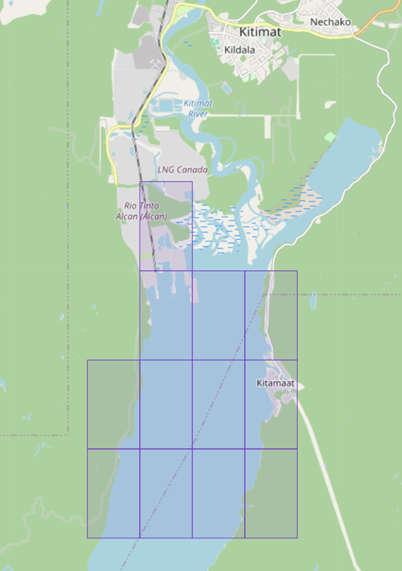
*204/26Canadian Hydrographic Service – S-102 Bathymetric Surface
The Member States of the International Hydrographic Organization (IHO) have adopted the first set of operational standards under the S-100 framework (Edition 5.2.0). Among these, the S-102 standard for Bathymetric Surface Products (Edition 3.0.0) has been officially published.
The Canadian Hydrographic Service (CHS) has produced and released its first 12 Level 6 cells (2-meter resolution) of S-102 products for the Canadian west coast in Kitimat Harbour. This milestone represents further advancement in the implementation of the IHO’s S-100 strategy and demonstrates operational capability to deliver next-generation navigational data.
Compliant with IHO Circular Letters and resolutions, this new product enhances navigational safety, supports interoperability with related datasets and strengthens the resilience of maritime information services. This achievement serves as a benchmark for hydrographic offices engaged in the global transition to S-100 standards.
S-102 Level 6 cells (2-meter resolution)
|
Level 6 cells (2-meter resolution) S-102 products – Kitimat Harbour |
||
|
S102CA0065400N12870W |
S102CA0065398N12870W |
S102CA0065398N12868W |
|
S102CA0065396N12872W |
S102CA0065396N12870W |
S102CA0065396N12868W |
|
S102CA0065394N12872W |
S102CA0065394N12870W |
S102CA0065394N12868W |
|
S102CA0065398N12866W |
S102CA0065396N12866W |
S102CA0065394N12866W |
*205/26Canadian Hydrographic Service – Electronic Navigational Charts
The Member States of the International Hydrographic
Organization (IHO) have adopted the first set of operational
standards under the S-100 framework (Edition 5.2.0). Among
these, S-101 standard relating to electronic navigational
charts (ENC), edition 2.0.0, has been officially published and
came into effect on January 1, 2026.
The Canadian Hydrographic Service (CHS) has produced and
released its first 6 S-101 products for the Canadian west
coast in Kitimat Harbour. This milestone represents further
advancement in the implementation of the IHO’s S-100 strategy
and demonstrates operational capability to deliver
next-generation navigational data. To this end, S-57 and
S-101 electronic charts are carefully synchronized in their
respective versions to ensure the “Dual Fuel” concept,
enabling a gradual transition to S-100 standards while
maintaining operational continuity.
Compliant with IHO Circular Letters and resolutions, this new product enhances navigational safety, supports interoperability with related datasets and strengthens the resilience of maritime information services. This achievement serves as a benchmark for hydrographic offices engaged in the global transition to S-100 standards.
|
NEW S-101 ENCs – Kitimat Harbour |
|
|
101CA00P540N1288Wv2u0 |
101CA00P539N1287Wv2u0 |
|
101CA00P540N1287Wv2u0 |
101CA00P538N1288Wv2u0 |
|
101CA00P539N1288Wv2u0 |
101CA00P538N1287Wv2u0 |
|
NEW S-57 ENCs – Kitimat Harbour |
|
|
CA56N4LAv2u0 |
CA56M4MAv2u0 |
|
CA56N4MAv2u0 |
CA56L4LAv2u0 |
|
CA56M4LAv2u0 |
CA56L4MAv2u0 |
|
ENC Cancellations |
|
|
CA571243v1u0 |
CA571246v1u0 |
|
CA571244v1u0 |
CA571247v1u0 |
|
CA571245v1u1 |
CA571248v1u0 |
*206/26North Thompson River – Waterway Information: Cable Ferry Operations
Cable ferry operations are taking place across the North Thompson River at Little Fort and McLure. Cable clearances may vary due to fixed aerial cable height and fluctuating water levels.
*211/26Victoria Harbour – Unlit Buoy Modified
Reference chart: 3412
The buoy designator of following unlit buoy has been modified from V22 to VL:
|
Aid Name |
LL No. |
Position |
|
Camel Point North Cautionary buoy VL |
5099.3 |
48° 25’ 09.9”N 123° 23’ 19.0”W |
(P2026-007)
Reminder – Comment Period for Active Preliminary Notices
This is a reminder that the comment period is still open for the following active Preliminary notices:
|
Notice # |
Reference Chart # |
Aids Affected |
Intent of Notice |
|
Pacific Coast |
|||
|
6258 |
1621.5 |
Aid to Navigation to be Discontinued |
|
|
Other Preliminary Notices |
|||
|
N/A |
N/A |
Navigational Warning (NAVWARN) Issuing System Update |
|
Please refer to the Notices to Mariners - Monthly Summary of Temporary and Preliminary Notices publication for details.
Pacific Coast
Temporary Notices
No notices applicable for this edition.
Preliminary Notices
No notices applicable for this edition.
Arctic Coast
Temporary Notices
No notices applicable for this edition.
Preliminary Notices
No notices applicable for this edition.
SECTION 2 - CHART CORRECTIONS
3419 - Esquimalt Harbour - New Edition - 13-DEC-2013 - World Geodetic System 1984
Download Patch - https://www.notmar.gc.ca/chsftp/patches/3419_6205372_1_202601141617.pdf
(See Chart 1, F22)
(See Chart 1, F22)
(See Chart 1, F22)
(See Chart 1, F22)
(See Chart 1, F22)
(See Chart 1, F22)
(See Chart 1, F16)
48°26′46.3″N 123°26′10.7″W
48°26′46.4″N 123°26′10.7″W
48°26′46.5″N 123°26′12.1″W
48°26′46.1″N 123°26′12.2″W
48°26′46.1″N 123°26′10.7″W
and 48°26′46.3″N 123°26′10.7″W
(See Chart 1, F16)
48°26′46.6″N 123°26′09.9″W
48°26′46.7″N 123°26′09.9″W
48°26′46.8″N 123°26′10.8″W
48°26′46.6″N 123°26′10.9″W
48°26′46.5″N 123°26′10.0″W
and 48°26′46.6″N 123°26′09.9″W
(See Chart 1, F22)
(See Chart 1, F4.1)
48°26′45.1″N 123°26′54.5″W
48°26′43.9″N 123°26′54.6″W
48°26′43.9″N 123°26′54.4″W
and 48°26′45.1″N 123°26′54.2″W
(See Chart 1, F16)
48°26′34.9″N 123°26′59.7″W
48°26′34.5″N 123°27′01.0″W
48°26′34.4″N 123°27′00.9″W
48°26′34.8″N 123°26′59.6″W
and 48°26′34.3″N 123°27′01.2″W
3441 - Haro Strait, Boundary Pass and/et Satellite Channel - New Edition - 01-JUL-2005 - NAD 1983
(See Chart 1, K26)
(See Chart 1, M50)
48°35′23.0″N 123°02′31.0″W
48°37′22.4″N 123°05′47.8″W
48°37′31.3″N 123°06′14.2″W
48°37′38.6″N 123°06′56.1″W
48°37′44.5″N 123°08′03.2″W
48°37′53.6″N 123°10′53.6″W
48°37′55.5″N 123°15′10.5″W
48°38′02.4″N 123°15′58.3″W
48°38′13.9″N 123°16′45.5″W
48°39′11.9″N 123°19′52.6″W
48°39′26.1″N 123°20′29.3″W
48°39′27.4″N 123°20′36.7″W
48°39′26.3″N 123°20′45.9″W
48°38′24.3″N 123°23′21.6″W
48°38′23.8″N 123°23′24.4″W
48°38′23.9″N 123°23′27.1″W
48°38′24.5″N 123°23′29.9″W
and 48°38′32.5″N 123°23′42.8″W
(See Chart 1, M50)
48°35′14.4″N 123°02′13.2″W
48°35′13.4″N 123°02′04.6″W
48°35′14.0″N 123°01′57.5″W
and 48°35′17.2″N 123°01′49.7″W
3447 - Nanaimo Harbour and/et Departure Bay - New Edition - 15-APR-2022 - World Geodetic System 1984
(See Chart 1, F16)
49°10′52.6″N 123°56′39.4″W
49°10′52.6″N 123°56′38.5″W
49°10′52.3″N 123°56′38.5″W
49°10′52.3″N 123°56′37.1″W
49°10′52.5″N 123°56′37.1″W
49°10′52.5″N 123°56′37.0″W
49°10′52.6″N 123°56′37.0″W
49°10′52.6″N 123°56′36.7″W
49°10′52.9″N 123°56′36.7″W
and 49°10′52.9″N 123°56′39.4″W
(See Chart 1, F22)
(See Chart 1, F22)
(See Chart 1, F22)
(See Chart 1, F16)
49°10′51.8″N 123°56′36.1″W
49°10′51.8″N 123°56′35.8″W
49°10′51.6″N 123°56′35.8″W
49°10′51.6″N 123°56′35.7″W
49°10′51.5″N 123°56′35.7″W
49°10′51.5″N 123°56′35.0″W
49°10′52.6″N 123°56′35.0″W
49°10′52.6″N 123°56′35.6″W
49°10′52.4″N 123°56′35.6″W
and 49°10′52.4″N 123°56′36.1″W
(See Chart 1, F16)
49°10′51.8″N 123°56′34.9″W
49°10′51.8″N 123°56′34.5″W
49°10′52.5″N 123°56′34.4″W
and 49°10′52.5″N 123°56′34.8″W
(See Chart 1, F13)
49°09′54.4″N 123°55′46.8″W
49°09′53.8″N 123°55′47.3″W
49°09′53.8″N 123°55′47.1″W
49°09′53.5″N 123°55′47.3″W
49°09′53.4″N 123°55′47.2″W
49°09′54.7″N 123°55′46.0″W
49°09′54.8″N 123°55′46.3″W
49°09′54.4″N 123°55′46.7″W
and 49°09′54.6″N 123°55′47.2″W
(See Chart 1, F13)
49°09′55.4″N 123°55′45.8″W
49°09′55.2″N 123°55′45.6″W
49°09′54.9″N 123°55′45.9″W
49°09′54.8″N 123°55′45.8″W
49°09′55.7″N 123°55′45.0″W
and 49°09′55.8″N 123°55′45.3″W
(See Chart 1, F22)
(See Chart 1, F22)
(See Chart 1, F22)
(See Chart 1, F22)
(See Chart 1, F22)
3447 - Newcastle Island Passage - New Edition - 15-APR-2022 - World Geodetic System 1984
(See Chart 1, F16)
49°10′52.6″N 123°56′39.4″W
49°10′52.6″N 123°56′38.5″W
49°10′52.3″N 123°56′38.5″W
49°10′52.3″N 123°56′37.1″W
49°10′52.5″N 123°56′37.1″W
49°10′52.5″N 123°56′37.0″W
49°10′52.6″N 123°56′37.0″W
49°10′52.6″N 123°56′36.7″W
49°10′52.9″N 123°56′36.7″W
and 49°10′52.9″N 123°56′39.4″W
(See Chart 1, F22)
(See Chart 1, F22)
(See Chart 1, F22)
(See Chart 1, F16)
49°10′51.8″N 123°56′36.1″W
49°10′51.8″N 123°56′35.8″W
49°10′51.6″N 123°56′35.8″W
49°10′51.6″N 123°56′35.7″W
49°10′51.5″N 123°56′35.7″W
49°10′51.5″N 123°56′35.0″W
49°10′52.6″N 123°56′35.0″W
49°10′52.6″N 123°56′35.6″W
49°10′52.4″N 123°56′35.6″W
and 49°10′52.4″N 123°56′36.1″W
(See Chart 1, F16)
49°10′51.8″N 123°56′34.9″W
49°10′51.8″N 123°56′34.5″W
49°10′52.5″N 123°56′34.4″W
and 49°10′52.5″N 123°56′34.8″W
3456 - Halibut Bank to/à Ballenas Channel - New Chart - 01-JUL-2011 - NAD 1983
(See Chart 1, F16)
49°10′52.6″N 123°56′39.4″W
49°10′52.6″N 123°56′38.5″W
49°10′52.3″N 123°56′38.5″W
49°10′52.3″N 123°56′37.1″W
49°10′52.5″N 123°56′37.1″W
49°10′52.5″N 123°56′37.0″W
49°10′52.6″N 123°56′37.0″W
49°10′52.6″N 123°56′36.7″W
49°10′52.9″N 123°56′36.7″W
and 49°10′52.9″N 123°56′39.4″W
3462 - Juan de Fuca Strait to/à Strait of Georgia - New Edition - 01-JUL-2005 - NAD 1983
(See Chart 1, K26)
(See Chart 1, M50)
48°37′53.7″N 123°10′44.1″W
48°37′54.5″N 123°14′54.5″W
48°38′01.1″N 123°15′49.3″W
48°38′12.2″N 123°16′37.2″W
48°39′15.4″N 123°20′06.7″W
48°39′25.9″N 123°20′44.0″W
48°38′23.3″N 123°23′17.1″W
48°38′23.3″N 123°23′25.0″W
48°38′25.3″N 123°23′33.2″W
and 48°38′31.8″N 123°23′44.5″W
3463 - Strait of Georgia, Southern Portion/Partie Sud - New Edition - 01-JUL-2005 - NAD 1983
(See Chart 1, N49)
and 49°00′08.7″N 122°45′05.0″W
3479 - Approaches to/Approches à Sidney - New Chart - 18-MAY-2007 - NAD 1983
(See Chart 1, K26)
(See Chart 1, M50)
48°38′03.9″N 123°16′05.4″W
48°38′13.9″N 123°16′45.5″W
48°39′11.9″N 123°19′52.6″W
48°39′26.1″N 123°20′29.3″W
48°39′27.4″N 123°20′36.7″W
48°39′26.3″N 123°20′45.9″W
48°38′24.3″N 123°23′21.6″W
48°38′23.8″N 123°23′24.4″W
48°38′23.9″N 123°23′27.1″W
48°38′24.5″N 123°23′29.9″W
and 48°38′32.5″N 123°23′42.8″W
3479 - SIDNEY - NEW CHART - 18-MAY-2007 - NAD 1983
(See Chart 1, M50)
and 48°38′25.2″N 123°23′31.1″W
(See Chart 1, M50)
and 48°38′35.0″N 123°22′54.7″W
3490 - Fraser River/Fleuve Fraser, Sand Heads to/à Douglas Island, Compartment A-B - New Edition - 02-NOV-2012 - World Geodetic System 1984
(See Chart 1, P20.2)
(See Chart 1, P16)
(See Chart 1, P20.2)
3605 - Quatsino Sound to/à Queen Charlotte Strait - New Edition - 06-MAR-1998 - NAD 1983
Download Patch - https://www.notmar.gc.ca/chsftp/patches/3605_6205362_1_202601291713.pdf
3673 - Clayoquot Sound, Tofino Inlet to/à Millar Channel - New Chart - 01-DEC-1995 - NAD 1983
(See Chart 1, I10)
(See Chart 1, I10)
(See Chart 1, K11)
(See Chart 1, I10)
3679 - Quatsino Sound - New Chart - 14-JUN-1991 - NAD 1983
(See Chart 1, L30.1)
50°31′36.2″N 128°00′46.4″W
50°31′15.9″N 128°00′36.5″W
50°30′59.9″N 128°00′48.7″W
50°30′45.5″N 128°01′16.4″W
50°30′22.9″N 128°01′37.8″W
50°30′17.2″N 128°01′57.7″W
50°29′32.6″N 128°02′18.1″W
50°28′01.3″N 128°00′55.2″W
50°27′42.6″N 128°00′10.0″W
50°27′39.8″N 127°59′38.5″W
50°27′50.5″N 127°59′06.4″W
50°27′51.6″N 127°58′19.9″W
50°27′45.0″N 127°57′49.2″W
50°28′07.8″N 127°56′17.1″W
50°28′13.7″N 127°55′16.8″W
50°28′11.0″N 127°53′18.4″W
50°28′24.2″N 127°52′04.7″W
50°28′58.6″N 127°51′52.5″W
50°28′57.7″N 127°50′50.1″W
50°28′24.3″N 127°49′12.1″W
50°28′20.0″N 127°48′19.7″W
50°28′44.6″N 127°47′44.2″W
50°29′02.5″N 127°47′07.6″W
50°29′30.0″N 127°47′05.7″W
50°29′54.9″N 127°45′46.4″W
50°30′05.6″N 127°44′05.6″W
50°30′15.6″N 127°41′40.0″W
50°30′56.5″N 127°41′09.0″W
50°31′39.2″N 127°39′44.3″W
50°31′41.0″N 127°39′06.1″W
50°31′35.9″N 127°37′47.7″W
50°31′41.6″N 127°37′33.8″W
50°31′55.6″N 127°37′27.9″W
50°32′01.6″N 127°37′31.6″W
and 50°32′13.7″N 127°37′26.7″W
(See Chart 1, L30.1)
50°25′49.9″N 127°29′44.0″W
50°26′14.0″N 127°30′32.7″W
50°26′52.3″N 127°31′10.5″W
50°29′38.8″N 127°34′27.4″W
50°30′12.0″N 127°35′17.8″W
50°30′56.4″N 127°36′47.5″W
and 50°31′55.6″N 127°37′27.9″W
(See Chart 1, L30.1)
50°31′55.2″N 127°37′22.1″W
50°31′45.8″N 127°36′50.7″W
50°32′00.5″N 127°36′08.2″W
50°32′03.5″N 127°35′13.7″W
50°31′59.9″N 127°34′43.8″W
50°31′56.0″N 127°34′41.8″W
50°31′53.7″N 127°34′16.0″W
50°32′05.1″N 127°33′55.4″W
50°32′48.1″N 127°33′47.4″W
50°32′58.7″N 127°33′33.5″W
50°33′25.8″N 127°33′22.5″W
50°33′51.3″N 127°33′39.0″W
50°34′11.3″N 127°34′18.3″W
and 50°34′28.5″N 127°34′38.6″W
(See Chart 1, L30.1)
50°38′55.8″N 127°59′54.7″W
50°38′21.4″N 127°58′35.7″W
50°38′07.2″N 127°56′34.5″W
50°37′47.8″N 127°54′48.4″W
50°37′34.1″N 127°53′57.2″W
50°37′20.4″N 127°53′28.7″W
50°37′18.3″N 127°53′11.3″W
50°37′10.3″N 127°52′54.0″W
50°37′13.9″N 127°52′39.0″W
50°36′59.5″N 127°51′18.0″W
50°36′35.9″N 127°49′49.1″W
50°36′01.4″N 127°47′16.4″W
50°35′53.8″N 127°44′35.8″W
50°35′33.3″N 127°43′09.4″W
50°35′23.7″N 127°39′25.3″W
and 50°35′18.4″N 127°36′38.3″W
3681 - Coal Harbour - New Chart - 08-JUN-1990 - NAD 1983
(See Chart 1, L30.1)
50°36′01.8″N 127°34′35.0″W
50°36′00.5″N 127°34′35.3″W
50°35′59.3″N 127°34′34.7″W
50°35′56.5″N 127°34′31.9″W
50°35′50.3″N 127°34′29.2″W
50°35′40.9″N 127°34′27.4″W
50°35′37.9″N 127°34′29.5″W
50°35′36.6″N 127°34′45.9″W
50°35′36.0″N 127°34′48.7″W
50°35′31.7″N 127°34′56.2″W
and 50°35′17.3″N 127°35′06.1″W
(See Chart 1, L30.1)
50°35′28.1″N 127°35′29.4″W
50°35′36.0″N 127°35′19.0″W
50°35′38.9″N 127°35′13.9″W
50°35′42.4″N 127°35′10.8″W
50°35′43.9″N 127°35′08.7″W
50°35′44.4″N 127°35′06.0″W
50°35′44.2″N 127°35′03.2″W
50°35′42.5″N 127°35′00.6″W
50°35′40.4″N 127°34′55.7″W
50°35′38.3″N 127°34′48.4″W
50°35′37.7″N 127°34′44.7″W
50°35′38.6″N 127°34′30.5″W
50°35′41.0″N 127°34′28.5″W
50°35′47.7″N 127°34′30.6″W
and 50°35′55.2″N 127°34′31.4″W
(See Chart 1, L30.1)
50°35′45.8″N 127°34′26.2″W
50°35′46.2″N 127°34′22.2″W
50°35′47.2″N 127°34′19.5″W
50°35′48.3″N 127°34′18.0″W
and 50°35′48.8″N 127°34′15.0″W
3681 - Neroutsos Inlet - New Chart - 08-JUN-1990 - NAD 1983
(See Chart 1, L30.1)
50°25′49.9″N 127°29′43.8″W
and 50°25′50.1″N 127°29′26.2″W
3681 - Quatsino Narrows - New Chart - 08-JUN-1990 - NAD 1983
(See Chart 1, L30.1)
50°31′56.1″N 127°37′25.1″W
50°31′47.2″N 127°36′56.4″W
50°31′47.0″N 127°36′45.2″W
50°31′59.7″N 127°36′10.5″W
50°32′02.6″N 127°35′39.5″W
50°32′03.2″N 127°35′10.3″W
50°32′00.0″N 127°34′47.2″W
50°32′00.1″N 127°34′43.4″W
50°31′58.1″N 127°34′43.5″W
50°31′56.3″N 127°34′42.3″W
50°31′53.9″N 127°34′31.6″W
50°31′55.2″N 127°34′29.5″W
50°31′55.2″N 127°34′24.0″W
50°31′54.1″N 127°34′18.7″W
50°31′56.9″N 127°34′09.7″W
50°32′00.8″N 127°34′03.0″W
50°32′01.4″N 127°33′59.3″W
50°32′07.2″N 127°33′53.8″W
50°32′12.9″N 127°33′54.9″W
50°32′22.5″N 127°33′52.1″W
50°32′25.7″N 127°33′53.2″W
50°32′29.3″N 127°33′52.8″W
50°32′36.8″N 127°33′48.8″W
50°32′44.3″N 127°33′48.5″W
50°32′50.8″N 127°33′44.8″W
50°32′57.4″N 127°33′35.3″W
50°33′15.6″N 127°33′25.6″W
50°33′21.1″N 127°33′25.3″W
50°33′24.9″N 127°33′22.9″W
50°33′32.5″N 127°33′26.2″W
50°33′48.5″N 127°33′37.6″W
50°33′53.7″N 127°33′46.0″W
50°33′56.4″N 127°33′48.1″W
and 50°34′00.0″N 127°33′55.0″W
(See Chart 1, L30.1)
50°31′41.6″N 127°37′34.3″W
50°31′44.6″N 127°37′31.5″W
50°31′53.7″N 127°37′28.6″W
50°31′56.2″N 127°37′29.0″W
50°31′58.5″N 127°37′31.4″W
50°32′01.4″N 127°37′31.7″W
50°32′05.9″N 127°37′29.0″W
50°32′12.7″N 127°37′29.0″W
and 50°32′14.1″N 127°37′26.9″W
(See Chart 1, L30.1)
50°31′58.8″N 127°37′30.0″W
50°31′37.3″N 127°37′15.1″W
50°31′19.4″N 127°37′04.8″W
50°31′15.7″N 127°37′03.2″W
and 50°31′00.0″N 127°36′48.9″W
3685 - TOFINO - NEW EDITION - 25-AUG-1995 - NAD 1983
Download Patch - https://www.notmar.gc.ca/chsftp/patches/3685_6205368_1_202601081427.pdf
3686 - Approaches to/Approches à Winter Harbour - New Chart - 08-APR-1988 - NAD 1983
(See Chart 1, L30.1)
50°28′13.7″N 127°55′16.8″W
50°28′06.7″N 127°56′24.2″W
50°28′04.3″N 127°56′34.1″W
50°27′52.3″N 127°57′13.4″W
50°27′45.0″N 127°57′56.6″W
50°27′48.9″N 127°58′02.3″W
50°27′51.8″N 127°58′23.4″W
50°27′51.1″N 127°59′04.5″W
50°27′39.8″N 127°59′36.2″W
50°27′42.6″N 128°00′10.0″W
50°27′56.9″N 128°00′46.2″W
50°28′11.9″N 128°01′05.5″W
50°29′29.6″N 128°02′15.9″W
50°29′38.5″N 128°02′16.3″W
50°30′17.4″N 128°01′57.1″W
50°30′20.3″N 128°01′49.3″W
50°30′22.9″N 128°01′37.7″W
50°30′28.9″N 128°01′30.5″W
50°30′37.6″N 128°01′23.3″W
50°30′45.5″N 128°01′16.4″W
50°30′52.4″N 128°01′05.0″W
50°31′00.2″N 128°00′48.2″W
50°31′14.1″N 128°00′37.2″W
50°31′24.1″N 128°00′38.8″W
50°31′34.5″N 128°00′45.4″W
50°31′37.5″N 128°00′51.4″W
50°31′38.5″N 128°00′57.8″W
and 50°31′38.2″N 128°01′01.5″W
3868 - Port Louis to/à Langara Island - New Edition - 05-MAY-2006 - NAD 1983
to 54°15′19.6″N 133°03′33.1″W
3912 - Inlets in/Entrée en Campania Island - New Edition - 14-AUG-2015 - World Geodetic System 1984
(See Chart 1, K11)
3921 - Allison Harbour - New Edition - 15-DEC-1995 - NAD 1983
(See Chart 1, K48.2)
(See Chart 1, F16)
51°06′03.9″N 127°32′41.9″W
51°06′04.3″N 127°32′42.0″W
51°06′04.2″N 127°32′42.9″W
and 51°06′03.8″N 127°32′42.8″W
3955 - Porpoise Harbour, Ridley Island and Approaches/et les Approches - New Edition - 29-APR-2022 - World Geodetic System 1984
(See Chart 1, F13)
54°14′06.9″N 130°18′50.6″W
54°14′07.5″N 130°18′50.7″W
54°14′07.5″N 130°18′51.2″W
54°14′07.7″N 130°18′51.6″W
and 54°14′07.1″N 130°18′53.5″W
(See Chart 1, F14)
54°14′08.6″N 130°18′48.6″W
54°14′07.8″N 130°18′47.8″W
and 54°14′06.2″N 130°18′52.7″W
(See Chart 1, F20)
(See Chart 1, F20)
(See Chart 1, F20)
(See Chart 1, F20)
3957 - Approaches to/Approches à Prince Rupert Harbour - New Edition - 07-OCT-2016 - World Geodetic System 1984
Download Patch - https://www.notmar.gc.ca/chsftp/patches/3957_6205364_3_202601291724.pdf
Download Patch - https://www.notmar.gc.ca/chsftp/patches/3957_6205364_4_202601291724.pdf
3958 - Prince Rupert Harbour - New Edition - 13-DEC-2013 - World Geodetic System 1984
(See Chart 1, F13)
54°14′07.7″N 130°18′50.4″W
54°14′07.4″N 130°18′50.1″W
54°14′06.7″N 130°18′50.1″W
and 54°14′05.9″N 130°18′52.0″W
(See Chart 1, F14)
54°14′08.6″N 130°18′48.6″W
54°14′07.8″N 130°18′47.8″W
and 54°14′05.9″N 130°18′52.0″W
(See Chart 1, F20)
(See Chart 1, F20)
(See Chart 1, F20)
(See Chart 1, F20)
(See Chart 1, I10)
3959 - Hudson Bay Passage - New Chart - 11-DEC-1987 - NAD 1983
Download Patch - https://www.notmar.gc.ca/chsftp/patches/3959_6205364_1_202601291725.pdf
Download Patch - https://www.notmar.gc.ca/chsftp/patches/3959_6205364_2_202601291726.pdf
3976 - Principe Channel to/à Douglas Channel - New Chart - 28-SEP-2018 - World Geodetic System 1984
(See Chart 1, K11)
3983 - Caamaño Sound to/à Principe Channel - New Chart - 26-MAY-2017 - World Geodetic System 1984
(See Chart 1, I10)
(See Chart 1, K11)
6417 - Tulita (Fort Norman), Police Island to/aux Halfway Islands Kilometre 810 / kilometre 860 - New Edition - 27-APR-2018 - NAD 1983
(See Chart 1, Qb)
to 64°53′52.7″N 125°37′28.4″W
(See Chart 1, Qc)
to 64°53′50.2″N 125°37′01.0″W
(See Chart 1, Qb)
to 64°53′41.8″N 125°35′56.7″W
(See Chart 1, Qc)
to 64°53′47.1″N 125°35′56.4″W
(See Chart 1, Qc)
to 64°53′44.1″N 125°35′06.6″W
6424 - Bryan Island to/à Travaillant River Kilometre 1240 / Kilomètre 1325 - New Edition - 11-MAR-2022 - World Geodetic System 1984
(See Chart 1, Qb)
(See Chart 1, Qb)
to 67°18′17.0″N 130°26′51.5″W
(See Chart 1, Qc)
to 67°17′36.2″N 130°26′01.7″W
(See Chart 1, Qc)
to 67°14′56.6″N 130°22′00.1″W
(See Chart 1, Qc)
(See Chart 1, Qc)
to 67°14′03.7″N 130°20′22.9″W
(See Chart 1, Qb)
(See Chart 1, Qc)
to 67°13′39.3″N 130°19′20.9″W
(See Chart 1, Qb)
(See Chart 1, Qc)
(See Chart 1, Qc)
(See Chart 1, Qb)
(See Chart 1, Qb)
(See Chart 1, Qc)
(See Chart 1, Qb)
6425 - Travaillant River to/à Adam Cabin Creek Kilometre 1325 / Kilomètre 1400 - New Edition - 10-JUN-2024 - World Geodetic System 1984
(See Chart 1, Qc)
(See Chart 1, Qb)
to 67°22′05.9″N 131°56′40.9″W
(See Chart 1, Qb)
to 67°21′58.2″N 131°55′26.5″W
(See Chart 1, Qc)
to 67°21′58.1″N 131°55′05.6″W
(See Chart 1, Qb)
to 67°21′51.3″N 131°54′10.7″W
(See Chart 1, Qb)
to 67°21′40.3″N 131°52′45.8″W
(See Chart 1, Qc)
to 67°21′43.7″N 131°52′29.3″W
(See Chart 1, Qb)
(See Chart 1, Qb)
SECTION 3 - RADIO AIDS TO MARINE NAVIGATION CORRECTIONS
*217/26Radio Aids to Marine Navigation 2026 (Atlantic, St. Lawrence, Great Lakes, Lake Winnipeg, Arctic and Pacific)
DELETE AS FOLLOWS:
2.1 Marine Communications and Traffic Services Centres
MMSI:
003160016 Call Sign: VCS
Hours: H24
Radio Services in English and in French.
All communications with Canadian Coast Guard Marine
Communications and Traffic Services Centres are recorded.
For Radio Services, call Halifax Coast Guard Radio.
For Vessel Traffic Services, call Halifax Traffic (Part 3.9.2 of this
publication) or Fundy Traffic (Part 3.9.1 of this
publication).
Coordinates
Mailing Address:
Fisheries and Oceans Canada
Canadian Coast Guard
Officer-in-Charge – MCTS Operations
Halifax MCTS Centre
10 Hudson Way
Dartmouth, NS B2Y 3Z8
Telephone:902-426-9750
or 902-426-9751 MCTS Operations
1-888-528-6444 MCTS Operations,
Toll-Free
902-426-4956 ECAREG
Facsimile:902-426-4483
Email: hlxecareg1@innav.gc.ca ECAREG Canada
Supervisor.mcts-halifax@dfo-mpo.gc.ca
DELETE AS FOLLOWS:
2.5 Radio Beacon Stations Continuously in Operations
Table 2-30 - Pacific Coast (Radio Beacons Located in British Columbia)
|
Name and Location |
Frequency (kHz) |
Range
|
Identifier |
Remarks |
|||
|
|
|
|
|
|
|
||
|
|
|
|
|
|
|
||
|
|
|
|
|
|
|
|
|
SECTION 4 - CANADIAN SAILING DIRECTIONS CORRECTIONS
The following Canadian Sailing Directions volumes have recently been updated on the Canadian Hydrographic Service website.
|
No. |
Title |
|
Atlantic Coast |
|
|
ATL 112 |
St. Lawrence River, Cap-Rouge to Montréal and Rivière Richelieu |
|
Pacific Coast |
|
|
PAC 201 |
Juan de Fuca Strait and Strait of Georgia |
|
PAC 202 |
Discovery Passage to Queen Charlotte Strait and West Coast of Vancouver Island |
Each volume includes a section entitled “Record of Changes” which lists all updates that are incorporated during the current calendar year.
SECTION 5 - LIST OF LIGHTS, BUOYS AND FOG SIGNALS CORRECTIONS
The amendments are highlighted and deletions are crossed out. For general and region-specific
information on the List of Lights, click on the following links:
Newfoundland and Labrador Coast,
Atlantic Coast,
Inland Waters and
Pacific Coast.
Pacific Coast
| No. ----- Intl No. |
Name ----- RACON |
Location ----- Latitude N. Longitude W. |
Light Characteristics |
Focal Height Above Water (m) |
Nominal Range (NM) |
Description ----- Height of Structure Above Ground Level (m) |
Remarks ----- Audible Signals ----- AIS |
|||
|---|---|---|---|---|---|---|---|---|---|---|
| KOOTENAY LAKE (LL 1 - 20) | ||||||||||
| 13.4 |
Kuskonook |
On S. extremity of pile breakwater marking entrance. Kootenay Lake. 49 18 00.2 116 39 47.4 |
Fl |
W |
4s |
4.6 |
6 |
Mast, on pile breakwater, green, white and black square daymark. |
Year round. |
|
| HARO STRAIT (LL 222.8 - 264) | ||||||||||
| 257 G5355 |
Beaver Point |
On N. tip of point. 48 46 15.5 123 22 01.6 |
Fl |
G |
4s |
9.4 |
5 |
White square tower with green band at top. |
Year round Radar reflector |
|
| FRASER RIVER - SOUTH ARM (LL 310 - 371) | ||||||||||
| 348.5 G5413.26 |
Deas Island front range light |
W. end of island. 49 07 06.6 123 04 33.1 |
Oc |
Y |
5s |
7.0 |
12 |
Square skeleton tower on 9-pile dolphin, red daymark with white vertical stripe. |
Year round. Operates 24 h. Flash 4.7 s; eclipse 0.3 s. Secondary light: Fl(2) R 6s. |
|
| 348.6 G5413.27 |
Deas Island rear range light |
49 07 08.4 123 04 24.1 073°24' 190.9 m from front. |
Oc(2) |
Y |
5s |
12.3 |
13 |
Square skeleton tower on 4-pile dolphin, white daymark with red vertical stripe. |
Year round. Operates 24 h. Flash 3.7 s; eclipse 0.3 s; flash 0.7 s; eclipse 0.3 s. |
|
| NORTHERN STRAIT OF GEORGIA (LL 447.5 - 510) | ||||||||||
| 498.5 G5541 |
Fanny Bay Breakwater |
End of floating breakwater. 49 30 30.7 124 49 36.5 |
Fl |
R |
4s |
3.2 |
4 |
Mast. |
Year round. |
|
| HAIDA GWAII (LL 768.6 - 812) | ||||||||||
| 803 G5850 |
George Point |
On point, entrance to Naden Harbour. 54 02 28.1 132 34 06.3 |
Q |
G |
1s |
2.8 |
3 |
White square skeleton tower with green |
Year round. |
|
Report a problem on this page
- Date modified: