
Archived information
The Standard on Web Usability replaces this content. This content is archived because Common Look and Feel 2.0 Standards have been rescinded.
Archived information is provided for reference, research or recordkeeping purposes. It is not subject to the Government of Canada Web Standards and has not been altered or updated since it was archived.
Notices to Mariners
June 24, 2022

Safety First, Service Always
Monthly Eastern Edition
CONTENTS
| Section 1 | General and Safety Information |
| Section 1A | Temporary and Preliminary Notices |
| Section 2 | Chart Corrections |
| Section 3 | Radio Aids to Marine Navigation Corrections |
| Section 4 | Canadian Sailing Directions Corrections |
| Section 5 | List of Lights, Buoys and Fog Signals Corrections |
Notices to Mariners – Monthly Eastern Edition
Edition No. 06/2022
Aussi disponible en français :
Avis aux navigateurs – Édition mensuelle de l’Est
Édition n° 06/2022
Published under the Authority of:
Canadian Coast Guard Programs
Aids to Navigation and Waterways
Fisheries and Oceans Canada
Montreal, QC H2Y 2E7
For more information, contact Notmar.XNCR@dfo-mpo.gc.ca.
© Her Majesty the Queen in Right of Canada,
as represented by the Minister of Fisheries, Oceans
and the Canadian Coast Guard, 2022.
Cat. No. Fs152-6E-PDF (Electronic PDF, English)
ISSN 1719-7708
Cat. No. Fs152-6F-PDF (Electronic PDF, French)
ISSN 1719-7716
Explanatory Notes – Notices to Mariners (NOTMAR)
Geographical positions refer directly to the graduations of the largest scale Canadian Hydrographic Service chart (unless otherwise indicated).
Bearings refer to the true compass and are measured clockwise from 000° (North) clockwise to 359°; those relating to lights are from seaward.
Visibility of lights is that in clear weather.
Depths - The units used for soundings (metres, fathoms or feet) are stated in the title of each chart.
Elevations are normally given above Higher High Water, Large Tide (unless otherwise indicated).
Distances may be calculated as follows:
1 nautical mile = 1,852 metres (6,076.1 feet)
1 statute mile = 1,609.3 metres (5,280 feet)
1 metre = 3.28 feet
Temporary and Preliminary Notices to Mariners – Section 1A of Notices to Mariners
These notices are indicated by a (T) or a (P), respectively. Please note that nautical charts are not amended by the Canadian Hydrographic Service for temporary (T) and preliminary (P) notices. It is recommended that mariners chart these corrections in pencil. For the list of charts affected by (T) & (P) notices, please refer to the current Notices to Mariners - Monthly Summary of Temporary and Preliminary Notices publication.
Suggestions and Corrections Form
This form is specifically for suggestions and corrections to Notices to Mariners publications. It is available online and also in fillable PDF format included with the monthly publication ZIP file.
To report chart discrepancies and/or corrections to the Canadian Sailing Directions booklets: Fill out the Marine Information Reporting Form and/or email chsinfo@dfo-mpo.gc.ca.
To report emergencies or navigational hazards: Contact your nearest MCTS centre
- VHF channel 16 (156.8 MHz)
- MF/HF frequency 2182 kHz/4125 kHz (where available)
- ∗16 on a cellphone (where available)
NOTMAR Website – Monthly Editions, Chart Corrections and Chart Patches
The NOTMAR website allows users to access the monthly publications,
chart corrections, and chart patches.
Users can subscribe for free to the email notification service
to receive notifications when charts of interest are updated, including their patches, as well as when a new Monthly Edition of Notices to Mariners is published.
In addition, the monthly publication and related
files to download, such as chart patches, can be obtained
all together through the download of a single ZIP file.
Explanatory Notes – Canadian Hydrographic Service (CHS)
Chart Corrections – Section 2 of Notices to Mariners
Corrections to nautical charts will be listed in numerical order by chart number. Each chart correction listed applies only to that particular chart. Related charts, if any, will have their own specific correction listed separately.
Users should also refer to CHS Chart 1: Symbols, Abbreviations and Terms for additional information pertaining to the correction of charts.
The illustration below describes the elements that will comprise a typical Section 2 chart correction:

The last correction number is identified with the LNM/D or Last Notice to Mariners Number / Date.
Mariners are advised that only the most critical changes that directly affect safety to navigation are issued in “Section 2 – Chart Corrections.” This limitation is required to ensure that charts remain as clear and easy to read as possible. As a result, mariners may see minor discrepancies of a non-critical nature between information in official publications. For example, a small change in the nominal range or focal height of a light may not result in the production of a chart correction in Notices to Mariners, but may result in a correction in the List of Lights, Buoys and Fog Signals publication.
Note: In the case of a discrepancy between information provided on CHS charts relating to aids to navigation, and the List of Lights, Buoys and Fog Signals publication, the latter shall be deemed as containing the most up-to-date information.
Canadian Nautical Charts & Publications
A source list of Canadian nautical charts and publications is published in Notice No. 14 of the Notices to Mariners Annual Edition 2022. The source supply and the prices effective at the time of printing are listed. For current chart edition dates, please refer to the following website: www.chs-shc.gc.ca/charts-cartes/paper-papier/index-eng.asp
Explanatory Notes – Marine Communications and Traffic Services (MCTS)
Navigational Warnings / Notices to Shipping
The Canadian Coast Guard (CCG) is implementing a number of changes to the aids to navigation system in Canada.
These changes are advertised as Navigational Warnings, formerly called Notices to ShippingFootnote 1, that are broadcast by the CCG, and are then followed up with Notices to Mariners, then charts are updated by hand correction, reprints or new editions.
Mariners are advised that all relevant Navigational Warnings (NAVWARN) should be kept until superseded by Notices to Mariners or through revised charts issued by the Canadian Hydrographic Service (CHS).
NAVWARN are accessible on the applicable regional page on the CCG Navigational Warnings website at http://nis.ccg-gcc.gc.ca.
CHS is reviewing the impact of these changes with CCG and together are preparing an action plan on the issuing of chart revisions.
For further information, contact your regional NAVWARN Issuing Desk.
Atlantic Region (North)
* Port aux Basques MCTS Centre
“N” Series NAVWARN
Canadian Coast Guard
49 Stadium Rd.
P.O. Box 99
Port aux Basques, NL A0M 1C0
Telephone: 709-695-2168 or 1-800-563-9089
Facsimile: 709-695-7784
Email: NAVWARN.MCTSPortAuxBasques@innav.gc.ca
Central Region
* Prescott MCTS Centre
“Q” and “C” Series NAVWARN
Canadian Coast Guard
401 King Street West
P.O. Box 1000
Prescott, ON K0E 1T0
Telephone: 613-925-0666
Facsimile: 613-925-4519
Email: NAVWARN.MCTSPrescott@innav.gc.ca
Atlantic Region (South)
* Sydney MCTS Centre
“M” Series NAVWARN
Canadian Coast Guard
1190 Westmount Road
Sydney, NS B1R 2J6
Telephone: 902-564-7751 or 1-800-686-8676
Facsimile: 902-564-7662
Email: NAVWARN.MCTSSydney@innav.gc.ca
Arctic Region
* Iqaluit MCTS Centre
Operational from approximately mid-May until late December.
“A” and “H” Series NAVWARN
Canadian Coast Guard
P.O. Box 189
Iqaluit, NU X0A 0H0
“A” Series NAVWARN
Telephone: 867-979-5269
“H” Series NAVWARN
Telephone: 867-979-0310
Facsimile: 867-979-4264
Email: NAVWARN.MCTSIqaluit@innav.gc.ca
* Service available in English and French.
Index
Numerical Index of Canadian Charts Affected
This numerical index lists all nautical charts mentioned in this monthly edition of Notices to Mariners. Only charts appearing in Section 2 of this publication require a chart correction. The appearance of charts in all other sections, particularly those related to the correction of other nautical publications, is included here for reference.
| 1203 | 4045 | 4468 | 4950 |
| 1220 | 4047 | 4485 | 4954 |
| 1230 | 4117 | 4615 | 4955 |
| 1311 | 4141 | 4617 | 4957 |
| 1313 | 4142 | 4619 | 5003 |
| 1320 | 4202 | 4622 | 5300 |
| 1429 | 4203 | 4624 | 5348 |
| 1430 | 4241 | 4667 | 5376 |
| 1433 | 4244 | 4745 | 5412 |
| 2042 | 4255 | 4820 | 5505 |
| 2291 | 4281 | 4825 | 5705 |
| 3955 | 4308 | 4839 | 6423 |
| 4001 | 4384 | 4842 | 6424 |
| 4003 | 4386 | 4845 | 6425 |
| 4006 | 4405 | 4861 | 6427 |
| 4015 | 4416 | 4864 | 8005 |
| 4016 | 4449 | 4913 | 8006 |
| 4022 | 4459 | 4920 | |
| 4024 | 4466 | 4940 |
SECTION 1 - GENERAL AND SAFETY INFORMATION
Canadian Coast Guard Publication – Comments and Suggestions on Notices to Mariners (NOTMAR) Publications
In an effort to continuously improve the Notices to Mariners publications and to provide the most efficient service possible, the Notices to Mariners team invites all mariners and other interested parties to submit comments and suggestions on possible improvements to its various publications and services at the following email address: Notmar.XNCR@dfo-mpo.gc.ca.
Transport Canada – COVID-19 Measures, Updates and Guidance
(Recurrent publication of notice *401/20, originally published in the Notices to Mariners – Monthly Eastern Edition 04/2020 publication.)
Please refer to the link below for the latest updates to
transportation related measures taken by Transport Canada in
response to the evolving novel Coronavirus disease
(COVID-19):
https://www.tc.gc.ca/en/initiatives/covid-19-measures-updates-guidance-tc.html.
For travel advice and all other updates, please visit: Canada.ca/coronavirus.
Transport Canada – Annual Edition of Notices to Mariners 2022 - Section A3, Notice 7A: Voyage Planning for Vessels Intending to Navigate in Canada's Northern Waters
(Recurrent publication of notice *206/22, originally published in the Notices to Mariners – Monthly Eastern Edition 02/2022 publication.)
Transport Canada has revised notice 7A, Voyage Planning for Vessels Intending to Navigate in Canada’s Northern Waters, of the Annual Edition of Notices to Mariners to reflect Arctic Shipping Safety and Pollution Prevention Regulations (ASSPPR) and to provide further guidance on voyage planning.
Protecting the North Atlantic Right Whale: Speed Restriction Measures in the Gulf of St. Lawrence
(Recurrent publication of notice *401/22, originally published in the Notices to Mariners – Special Edition 02/2022 publication.)
PURPOSE
This notice describes the speed restriction zones that vessels must follow in the Gulf of St. Lawrence.
The Government of Canada has established these zones to reduce the risk of vessel colliding with North Atlantic right whales (NARW).
BACKGROUND
Due to changing migration patterns of North Atlantic right whales and their increased presence in the Gulf of St. Lawrence, the Government of Canada has set seasonal speed restrictions in specific zones. These speed restrictions zones are defined as “static zones,” “dynamic shipping zones,” “seasonal management areas,” a trial “voluntary slowdown zone” and a “restricted area.” See the map below for details.
Note: Vessels must follow Navigational Warnings outlining the speed restrictions. The Interim Order for the Protection of North Atlantic Right Whales (Eubalaena Glacialis) in the Gulf of St. Lawrence, 2022 enables the issuance of Navigational Warnings (NAVWARNs) imposing speed restrictions and navigation restrictions.
Speed restriction zones are described in monthly Notices to Mariners (NOTMARs), which are published by the Canadian Coast Guard. The status of these zones is broadcast through NAVWARNs, which are published by the Coast Guard’s Marine Communications and Traffic Services Centres.
CHANGES TO SPEED RESTRICTION ZONES AND MEASURES
Based on consultations with industry and on scientific data, changes to the speed restriction zones will be effective from April 20, 2022, while the restricted area will be implemented based on whale presence:
•For a third and final year, a trial voluntary
slowdown of 10.0 knots over the ground spanning from
Cabot Strait (a line running from Cape North NS to Cape
Ray NL) to the eastern edge of dynamic shipping zone E will
be implemented at the beginning and end of the North Atlantic
right whale season.
•Again this year, a restricted area located in and
near Shediac Valley. The location and size are both based on
historical data of North Atlantic right whale aggregations,
while the triggering mechanism is based on in-season
detections.
•The 36.57 m (20-fathom) shallow water protocol will apply once again to all commercial fishing vessels.
Please check the latest NAVWARN for all speed restrictions currently in effect.
SPEED RESTRICTION MEASURES FOR 2022
These restrictions will be in effect from April 20 to November 15, 2022.
Exceptions
The following exception will apply to all measures:
a)a vessel in distress or providing assistance to a person or a vessel in distress;
b)a government vessel being used
(i) for law enforcement activities;
(ii) for search and rescue operations; or
(iii) to ensure the competency of the crew or the
operational readiness of the vessel or crew with respect to
such activities or operations.
STATIC ZONES
In the static zones, all vessels above 13 m in length overall (LOA) must proceed at a speed of not more than 10.0 knots over the ground.
Exceptions
Air cushion vessels operated by or on behalf of the Government of Canada that are engaged in ice-clearing activities from April to June in and around Chaleur Bay are exempted when in operation.
36.57 m (20-fathom) shallow water protocol
Vessels engaged in any commercial fishing activity may proceed at a safe operational speed in waters not more than 36.57 m (20 fathom) deep.
If a notice to fish harvesters states that at least one right whale has been detected within static zone in waters that are not more than 36.57 m deep, the 10 knots speed limit will apply to all vessels above 13 m in length overall (LOA) 15 days after the day on which the whale was detected.
If a new notice to fish harvesters is published or broadcast during the last seven days of the 15-day period, the speed limit will continue to apply for a further 15 days after the day on which the new detection took place.
|
Coordinates for the northern static zone: •50° 20’ N, 065° 00’ W
•49° 13’ N, 065° 00’ W •50° 20’ N, 063° 00’ W |
Coordinates for the southern static zone: •48° 40’ N, 065° 00’ W
•48° 40’ N, 062° 40’ W •47° 10’ N, 065° 00’ W |
DYNAMIC SHIPPING ZONES
There are five dynamic shipping zones (DSZ) located in the routeing systems north and south of Anticosti Island: A, B, C, D and E.
Coordinates for the dynamic shipping zones:
|
Zone A •49⁰ 41’ N, 065⁰ 00’ W
•49⁰ 20’ N, 065⁰ 00’ W •49⁰ 22’ N, 064⁰ 00’ W |
Zone B •49⁰ 22’ N, 064⁰ 00’ W
•49⁰ 11’ N, 064⁰ 00’ W •49⁰ 00’ N, 063⁰ 00’ W |
Zone C •49⁰ 00’ N, 063⁰ 00’ W
•48⁰ 48’ N, 063⁰ 00’ W •48⁰ 35’ N, 062⁰ 00’ W |
|
Zone D
•50⁰ 16’ N, 064⁰ 00’ W •50⁰ 16’ N, 063⁰ 00’ W |
Zone E
•48⁰ 35’ N, 062⁰ 00’ W •48⁰ 10.5’ N, 061⁰ 00’ W |
|
When a North Atlantic right whale is detected in a dynamic shipping zone:
•All vessels will be notified via a NAVWARN; and
•Vessels above 13 m in length overall
(LOA) must proceed at a speed of not more than 10.0 knots
over the ground within that zone.
Even though dynamic shipping zones overlap with static zones, vessels can travel at a safe operational speed in dynamic shipping zones when they are not under speed restriction. They must also keep in mind that North Atlantic right whales may be nearby.
Speed restrictions in the dynamic shipping zones
The detection of North Atlantic right whales in one or more dynamic shipping zone(s), will trigger a speed restriction in the concerned zone(s). The speed restriction in the dynamic shipping zone(s) will be in effect for 15 days from the date of detection. In the event of a new North Atlantic right whale detection occurring in the last 7 days of the 15-day slowdown period, the speed restriction may be extended for an additional 15 days from the date of the new detection. This would continue until no NARW are detected.
When a NAVWARN is issued implementing a speed restriction in one or more dynamic shipping zone(s), vessels above 13 m in length (LOA) must not exceed a speed of 10.0 knots over the ground. Within any dynamic zone that is not subject to a speed restriction, mariners may proceed at a safe operational speed. Mariners are encouraged to take into consideration the potential for their vessel striking North Atlantic right whales when considering a “safe operational speed” during navigation.
SEASONAL MANAGEMENT AREAS
Seasonal management area 1 (SMA-1) and seasonal management area 2 (SMA-2) are speed restriction areas located north and south of dynamic shipping zone E, respectively.
Within seasonal management areas, vessels above 13 m in length (LOA):
•must restrict their speed so as not to exceed 10.0 knots over the ground from April 20 to June 28, 2022; and
•are allowed to proceed at a safe operational speed from June 29 to November 15, 2022, unless a North Atlantic right whale is detected. If a whale is detected, a speed restriction of 10.0 knots over the ground will be triggered for 15 days from the date of detection. In the event of a new North Atlantic right whale detection occurring in the last 7 days of the 15-day slowdown period, the speed restriction may be extended for an additional 15 days from the date of the new detection. This would continue until no North Atlantic right whales are detected.
|
Coordinates for the SMA-1: •49° 04’ N, 062° 00’ W
•49° 04’ N, 061° 00’ W •48° 35’ N, 062° 00’ W |
Coordinates for the SMA-2: •48° 24’ N, 062° 00’ W
•48° 03’ N, 061° 07.5’ W •47° 26.69’ N, 062° 00’ W |
RESTRICTED AREA
In the summer months, an important proportion of the total
North Atlantic right whale population gathers for feeding and
surface activity near the Shediac
Valley. Since this makes the North Atlantic right whale
more susceptible to vessel collisions, a mandatory restricted
area will be implemented in and near the Shediac
Valley and will come into force once 80% of the
restricted area is closed to fishing for the season as per
the Department of Fisheries and Oceans’s right whale closure
protocol. The restricted area will be lifted once the
North Atlantic right whale detections decrease in the
restricted area.
The size and location of the area are determined based on
historical detection data of North Atlantic right whales. All
necessary details can be found in the Interim Order for
the Protection of North Atlantic Right Whales (Eubalaena
Glacialis) in the Gulf of St. Lawrence, 2022. Triggering
and lifting of the restricted area will be communicated to
mariners through a NAVWARN and notice to fish harvesters.
Vessels above 13 m in length (LOA) will be required to:
•avoid the area unless they are part of the exceptions listed in the Interim Order for the Protection of North Atlantic Right Whales (Eubalaena Glacialis) in the Gulf of St. Lawrence, 2022;
•transit the area at a speed not exceeding 8.0 knots over the ground if they are part of the exceptions.
The following exceptions will apply to the restricted area. Vessels listed can travel through the area at not more than 8.0 knots over the ground:
•A vessel being used for commercial fishing;
•A vessel being used for fishing under the authority
of a licence issued under the Aboriginal Communal Fishing
Licences Regulations;
•A vessel being used for research purposes on behalf
of the Government of Canada;
•A vessel being used as part of the Department of
Fisheries and Oceans’ Marine Mammal Response Program to
assist a marine mammal or sea turtle in distress or to access
or retrieve a deceased marine mammal or sea turtle;
•A vessel authorized by the Government of Canada to
retrieve or identify the location of abandoned or lost
fishing gear;
•A vessel involved in pollution response
operations;
•A vessel avoiding immediate or unforeseen danger;
•A vessel involved in research relating to right whales as part of a project that has received funding from the Government of Canada.
The following vessels can travel through the restricted area at a speed over 8.0 knots, but below 10.0 knots over the ground as required by the static speed restriction zone:
•A vessel being used by an employee of the Government of Canada or peace officer who is performing their duties.
The location and size of the restricted area will not be modified during the season.
Coordinates for the restricted area:
•48˚31.8’ N, 063˚39.6’ W
•48˚24.72’ N, 063˚17.88’ W
•47˚18.84’ N, 064˚10.8’ W
•47˚27.18’ N, 064˚30.72’ W
Inclement weather exception
Mariners will be notified in advance via a NAVWARN should the speed restriction status change in any zone or area, due to inclement weather.
Within any zone or area that is no longer subject to a speed
restriction due to adverse weather conditions, mariners may
proceed at a safe operational speed. Mariners are however
encouraged to take into consideration the potential for their
vessel striking North Atlantic right whales when considering
a “safe operational speed” during navigation.
*Non-excepted vessels are still prohibited from transiting
through the restricted area.
TRIAL VOLUNTARY SLOWDOWN IN CABOT STRAIT
To coincide with the North Atlantic right whales entering and exiting the Gulf of St. Lawrence in large numbers, a trial voluntary slowdown is being put in place for the third year in Cabot Strait from April 20 to June 28, 2022, and from September 28 to November 15, 2022.
•During these periods, vessels above 13 m in length (LOA) are requested to voluntarily reduce their speed as to not exceed 10.0 knots over the ground.
Voluntary slowdown zone coordinates:
•48° 10.5’ N, 061° 00’ W
•47° 37.2’ N, 059° 18.5’ W
•47° 02’ N, 060° 23.7’ W
•47° 58.1’ N, 061° 03.5’ W
•48° 00’ N, 061° 00’ W
MAP OF THE GULF OF ST. LAWRENCE
The following map shows
•the static zones (north and south), in pink;
•the dynamic shipping zones (A, B, C, D and E), in
green;
•the seasonal management areas, in dark pink;
•the trial voluntary slowdown zone, in grey;
•the restricted area, in dark blue; and
•the 36.57 m (20 fathom) shallow water protocol line.
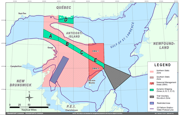
This map is for visual representation only and is not to be used for navigation or enforcement.
NAVWARN BROADCASTS
The Canadian Coast Guard issues NAVWARNs:
•by radio broadcast; and
•online at Canada’s Maritime Information Portal and its Navigational Warnings site.
Mariners must ensure they have accurate and up-to-date
information about the protection of the North Atlantic right
whale, as in all applicable NOTMARs and NAVWARNs.
For the North Atlantic right whale speed restrictions, the
NAVWARN(s) currently in effect will be provided to vessels
subject to the Vessel Traffic Services Zone Regulations
or the Eastern Canada Vessel Traffic Services Zone
Regulations:
Outbound vessels will receive NAVWARNs
•at Calling-in-Point 10 (St-Laurent); or
•upon a departure downstream from the Quebec pilot station (including the Saguenay River, Chaleur Bay, Miramichi Bay, etc.)
Inbound vessels will receive NAVWARNs
•when a clearance to enter Canadian waters is granted
Vessels in transit will receive NAVWARNs
•at the last reporting point prior to entering the mandatory speed restriction zones; and/or
•at 10 nautical miles before they enter the mandatory speed restriction zones
For those vessels not subject to the above-mentioned regulations, vessel operators are required to monitor broadcasts by the Canadian Coast Guard’s Marine Communications and Traffic Services network for the most up-to-date information. For marine radio frequencies and broadcast times, information may be found in the Radio Aids to Marine Navigation publication.
AIDS TO NAVIGATION
The Canadian Coast Guard is currently testing virtual Automatic Identification System (AIS) aids to navigation (AIS AtoN) in specific areas. These aids notify mariners of a dynamic shipping zone and/or a seasonal management area subject to a speed restriction.
Each zone is delimited by four to six virtual AIS AtoN, which can be displayed on a ship’s navigation equipment, such as
•Electronic Chart Display and Information System
(ECDIS);
•Electronic Chart System (ECS);
•RADAR;
•Minimum Keyboard Display (MKD); and
•Electronic Nautical Chart (ENC).
The Canadian Coast Guard broadcasts the virtual AIS AtoN only
when a speed restriction is in effect in one or more testing
zones.
Mariners must select the virtual AIS AtoN symbol to view a
message such as “SectA1 Spd Lim 10 kt.” This message refers
to a speed restriction in effect for a specific zone.
Note: This system is not the primary method of communicating this information.
COMPLIANCE AND ENFORCEMENT
Vessels must comply with the Interim Orders made pursuant to the Canada Shipping Act, 2001, and any NAVWARNs broadcast and published by the Canadian Coast Guard relating to the Interim Orders, aimed at regulating the navigation for the purposes of protecting the North Atlantic right whales.
If a vessel does not comply with the Interim Orders or instructions in the NAVWARNs related to the Interim Orders, the vessel could face:
•administrative monetary penalties up to a maximum of CAN $250,000; and/or
•penal sanctions under the Canada Shipping Act, 2001.
If a vessel appears to have violated the speed restriction,
Transport Canada Marine Safety inspectors will review all
information provided through AIS and seek an explanation from
the master.
No exemptions to the speed restriction will be granted in
advance. However, if a deviation from the speed restrictions
is necessary for safety reasons, the following information
must be entered into the bridge logbook:
•reason(s) for deviation;
•speed at which vessel is operated;
•latitude and longitude at time of deviation;
•time and duration of deviation; and
•master of the vessel shall sign and date the bridge logbook entry.
For any deviation, Transport Canada will review and consider reasons such as:
•navigating to ensure vessel safety;
•weather conditions;
•force majeure (unforeseeable circumstances); and
•responding to emergencies.
REPORT A NORTH ATLANTIC RIGHT WHALE SIGHTING
If you see live, free-swimming whales:
•Call 1-902-440-8611 (local) or 1-844-800-8568 (toll free)
•Email: XMARWhalesightings@dfo-mpo.gc.ca
If you see a North Atlantic right whale that is entangled, injured or dead, please report it to your nearest Canadian Coast Guard Marine Communications and Traffic Services Centre, or call:
Southern part of the Gulf of St. Lawrence
Marine Animal Response Society
Telephone: 1-866-567-6277
Newfoundland and Labrador
Whale Release and Strandings
Telephone: 1-888-895-3003
For the Québec Sector
Marine Mammal Emergencies
Telephone: 1-877-722-5346
Please consult WhaleMap for the latest right whale observations: https://whalemap.ocean.dal.ca/
Saguenay–St. Lawrence Marine Park and Surrounding Waters – Whale Protection
(Recurrent publication of notice *406/22, originally published in the Notices to Mariners – Monthly Eastern Edition 04/2022 publication.)
The waters in and around the Saguenay–St. Lawrence Marine Park are well known for the resident endangered beluga population and the wide diversity of whales that migrate there to feed, particularly between April and November.
REGULATORY PROTECTION MEASURES
All whale species that are found in the St. Lawrence are
protected under the Marine Mammal Regulations,
pursuant to the Fisheries Act. Within the boundaries
of the Marine Park, specific measures are set out in the
Marine Activities in the Saguenay–St. Lawrence Marine
Park Regulations, pursuant to the establishment of the
Saguenay–St. Lawrence Marine Park Act. Any collision
with a marine mammal within the Marine Park must immediately
be reported to a park warden at 1-866-508-9888. For
collisions that occur outside the Marine Park or for any
situation involving a marine mammal that is dead or in
trouble, contact the emergency network at 1-877-722-5346 or
on VHF channel 16.
For more information on the Saguenay–St. Lawrence Marine
Park, see notice 5C of the Notices to Mariners Annual
Edition 2022.
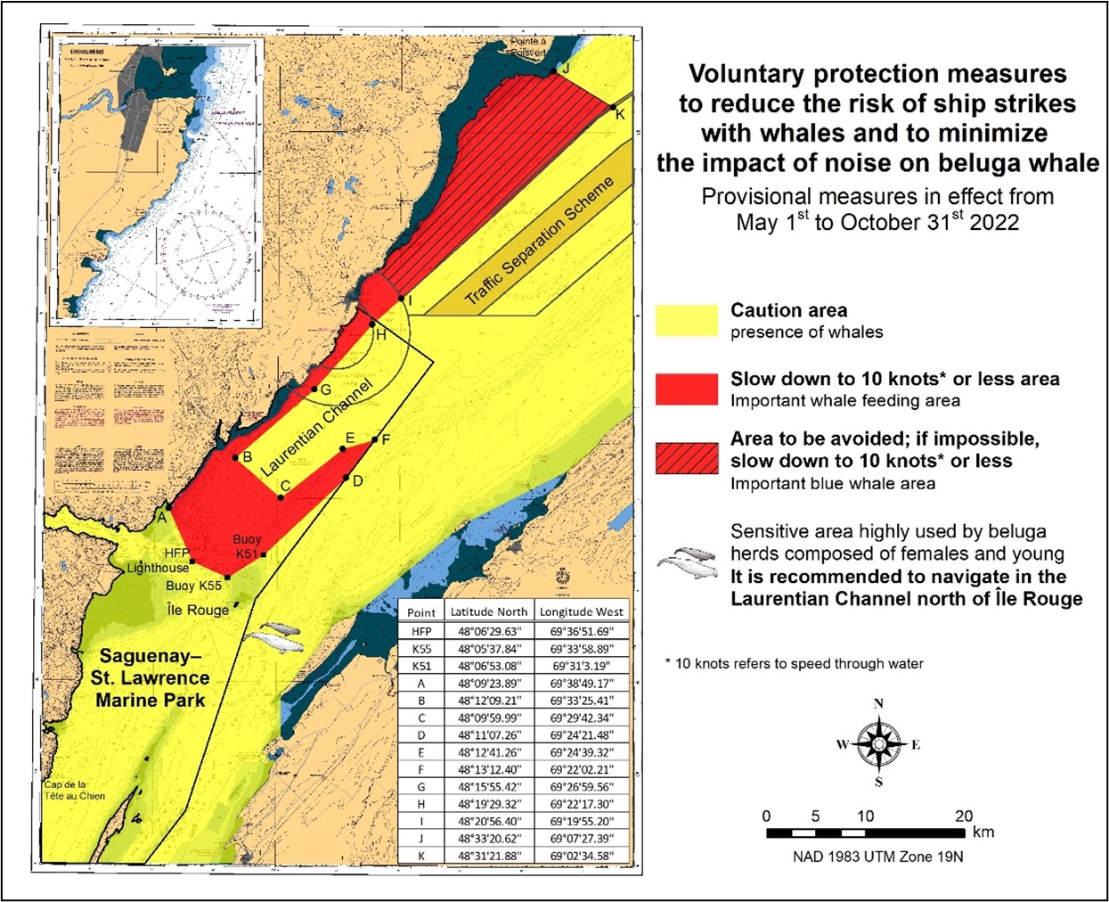
VOLUNTARY PROTECTION MEASURES
Provisional measures in effect from May 1 to October 31, 2022. See map at the end of this notice.
These measures apply to merchant vessels and cruise ships between Pointe à Boisvert and Cap de la Tête au Chien to prevent collisions with whales. These measures should only be taken when they will not jeopardize navigational safety.
Caution area (yellow area): To reduce the risk of collisions with whales that can be present anywhere in this area, heightened vigilance of navigators is critical. Posting a lookout is recommended in order to increase the chances of seeing the whales and thus taking necessary measures to avoid them. If bypassing the whales is not possible, slow down and wait for the animals to move away to a distance greater than 400 metres (0.215 nautical miles) before resuming original speed. It is more difficult to see the animals at night therefore increased caution is recommended.
Slow down to 10 knots or less area (red area): To reduce the risk of collisions with whales in this feeding area, it is recommended that vessels slow down to a maximum speed through the water of 10 knots and post a lookout. It is further recommended to remain in the Laurentian Channel to the north of Île Rouge to minimize the impact of noise in a sensitive area south of this island, which is highly frequented by herds of beluga whales composed of females and young.
Area to be avoided (hatched red area): To reduce noise and the risk of collisions with whales, vessels should avoid transiting through this area which is highly frequented by blue whales, an endangered species. If the area cannot be avoided, slow down to a speed through the water of 10 knots or less.
Saguenay–St. Lawrence Marine Park - Beluga Whale Protection: Slowdown Area at the Mouth of the Saguenay Fjord and Area Closure at Baie Sainte-Marguerite
(Recurrent publication of notice *407/22, originally published in the Notices to Mariners – Monthly Eastern Edition 04/2022 publication.)
The Saguenay–St. Lawrence Marine Park and its surrounding
area are at the heart of endangered beluga whale critical
summer habitat. Marine mammal protection measures have been
put in place in accordance with the Marine Activities in
the Saguenay–St. Lawrence Marine Park Regulations within
the limits of the Marine Park.
However, important feeding, calving and rearing areas for
beluga whales require greater protection to ensure the
recovery of the species. The portion of the Saguenay situated
between the mouth of the Fjord and Baie Sainte-Marguerite is
one of the areas most used by females and their young from
May to October. The mouth of the Saguenay is known as a
feeding ground and Baie Sainte-Marguerite as a calving and
rearing area.
In order to prevent collisions with beluga whales, a
compulsory 15-knot slowdown area is in effect from
May 1st to October 31st at the
mouth of the Saguenay. To ensure tranquility for female
belugas and their young during the critical calving period,
access to Baie Sainte-Marguerite is prohibited to all vessels
from June 21st to September 21st,
except for special authorizations (see description
below).
For safety reasons, the slowdown area measure at
the mouth of the Saguenay Fjord does not apply
to cargo ships (see the monthly edition of Notice to
Mariners from May to October for voluntary protection
measures in the St. Lawrence Estuary). An enhanced vigilance
is, however, recommended to all navigators between the mouth
of the Saguenay Fjord and Baie Sainte-Marguerite for the
protection of beluga whales.
For more information on the Saguenay–St. Lawrence Marine
Park, see notice 5C of the Notices to Mariners Annual
Edition 2022 or visit marinepark.qc.ca.
REGULATORY PROTECTION MEASURES — BELUGA WHALE
Entire Marine Park Territory:
•When beluga whales are less than half a nautical mile
(926 metres) from a motorized vessel, the vessel must
maintain a steady speed of between 5 and 10 knots.
•All vessels, including human-powered vessels (kayaks
and canoes), must continue to move forward and maintain their
heading.
•All vessels must maintain a minimum distance of 400 metres from beluga whales at all times.
For more information concerning the regulations, consult: marinepark.ca/protect/.
Mouth of the Saguenay Fjord (Figure 1) — Slowdown Area (area crosshatched in red):
•Maximum speed at the mouth of the Saguenay between buoys S7 and S8 and the ferry docks between Baie-Sainte-Catherine and Tadoussac is 15 knots from May 1st to October 31st.
Baie Sainte-Marguerite (Figure 2) — Area Closure (red area):
•From June 21st to September 21st, vessels must not enter the red area, which follows a line between Cap Nord-Ouest and Cap Sainte-Marguerite.
•Special authorizations are granted only for kayaks, canoes and recreational fishermen who must travel without stopping along a corridor within 10 metres of the shore or in shallow areas.
VOLUNTARY PROTECTION MEASURES
Baie Sainte-Marguerite sector (Figure 2) — Transit Area (area crosshatched in yellow):
•From June 21st to September 21st, navigation in this area is recommended at a speed of between 5 and 10 knots without stopping.
The purpose of this transit area is to favour respect of the Marine Activities in the Saguenay–St. Lawrence Marine Park Regulations, since beluga whales are often present in the Baie Sainte-Marguerite sector.
INFORMATION
All incidents, including collisions with whales, must be reported without delay by calling 1-866-508-9888. For any other situation concerning a marine mammal that is either dead or in trouble, contact the Marine Mammal Emergency Response Network at 1-877-722-5346, or use VHF channel 16.
Figure 1

Figure 2

*601/22Canadian Hydrographic Service – Nautical Charts
|
Charts |
Main Title |
Scale |
Published |
Cat# |
Price |
|
New Editions |
|||||
|
3955 |
Plans - Prince Rupert Harbour |
1:20 000 |
2022-06-10 |
2 |
$20.00 |
|
6423 |
Askew Islands to/à Bryan Island Kilometre 1180 / Kilometre 1240 |
1:50 000 |
2022-06-10 |
4 |
$12.00 |
|
6424 |
Bryan Island to/à Travaillant River Kilometre 1240 / Kilomètre 1325 |
1:50 000 |
2022-06-10 |
4 |
$12.00 |
|
6425 |
Travaillant River to/à Adam Cabin Creek Kilometre 1325 / Kilomètre 1400 |
1:50 000 |
2022-06-10 |
4 |
$12.00 |
|
6427 |
Point Separation to/au Aklavik Channel Kilometre 1480 / Kilomètre 1540 |
1:50 000 |
2022-06-10 |
4 |
$12.00 |
*602/22Canadian Hydrographic Service – Electronic Navigational Charts
|
S-57 ENC Number |
Chart Title |
ENC Compilation Scale |
Published |
|
New Charts |
|||
|
CA373482 (Edn 1.000) |
Strathcona Sound and/et Adams Sound |
1:40 000 |
2022-06-10 |
|
CA571090 (Edn 1.000) |
CA571090 |
1:0 |
2022-06-17 |
|
CA571091 (Edn 1.000) |
CA571091 |
1:0 |
2022-06-17 |
|
CA571094 (Edn 1.000) |
CA571094 |
1:0 |
2022-06-17 |
|
CA571095 (Edn 1.000) |
CA571095 |
1:0 |
2022-06-17 |
|
CA670760 (Edn 1.000) |
Squamish Berth 1 |
1:1 000 |
2022-06-03 |
|
New Editions |
|||
|
CA373071 (Edn 8.000) |
Main Duck Island to/à Scotch Bonnet Island |
1:77 700 |
2022-06-03 |
|
CA373090 (Edn 7.000) |
Pointe aux Pins to/à Point Pelee |
1:100 000 |
2022-06-03 |
|
CA373262 (Edn 8.000) |
Victoria Strait |
1:75 000 |
2022-06-03 |
|
CA376356 (Edn 3.000) |
Quaker Hat to/à Cape Harrison |
1:30 000 |
2022-06-03 |
|
CA376358 (Edn 3.000) |
Green Bay to/à Double Island |
1:30 000 |
2022-06-10 |
|
CA376361 (Edn 3.000) |
Cape Makkovik to/à Winsor Harbour Island |
1:30 000 |
2022-06-03 |
|
CA376362 (Edn 3.000) |
Kaipokok Bay |
1:30 000 |
2022-06-03 |
|
CA376370 (Edn 3.000) |
Cape Harrison to Dog Islands |
1:30 000 |
2022-06-03 |
|
CA376665 (Edn 2.000) |
Hare Islands to/à North Head |
1:50 000 |
2022-06-24 |
|
CA376739 (Edn 2.000) |
Epinette Point to/à Terrington Basin |
1:30 000 |
2022-06-03 |
|
CA376822 (Edn 3.000) |
Winsor Harbour Island to/aux Kikkertaksoak Islands |
1:30 000 |
2022-06-03 |
|
CA376823 (Edn 3.000) |
Winsor Harbour Island to/aux Kikkertaksoak Islands |
1:30 000 |
2022-06-10 |
|
CA479021 (Edn 11.000) |
Cap aux Oies à/to Sault-au-Cochon |
1:45 000 |
2022-06-10 |
|
CA479228 (Edn 4.000) |
Lac Saint-Louis |
1:22 000 |
2022-06-10 |
|
CA570168 (Edn 7.000) |
Port Alberni |
1:6 000 |
2022-06-10 |
|
CA570383 (Edn 13.000) |
Nanaimo Harbour and/et Departure Bay |
1:5 000 |
2022-06-03 |
|
CA579022 (Edn 11.000) |
Saint-Joseph-de-la-Rive |
1:4 000 |
2022-06-10 |
|
CA579023 (Edn 13.000) |
L'Isle-aux-Coudres |
1:4 000 |
2022-06-10 |
|
CA579024 (Edn 8.000) |
Saint-Jean-Port-Joli |
1:4 000 |
2022-06-10 |
|
CA579098 (Edn 6.000) |
Havre de Natashquan et les approches/and Approaches |
1:8 000 |
2022-06-03 |
|
CA579229 (Edn 3.000) |
Rapides de Vaudreuil |
1:8 000 |
2022-06-10 |
|
Charts Permanently Withdrawn |
|||
|
CA476666 |
Saglek Bay |
|
|
|
CA570080 |
Stewart |
Cancelled by CA571095, CA571094, CA571091, CA571090 |
|
|
CA670741 |
Stewart - World Port and/et Bulk Terminal |
Cancelled by CA571091, CA571090 |
|
*603/22Canadian Hydrographic Service – Raster Digital Charts (BSB V3)
|
Charts |
Main Title |
Scale |
Published |
|
New Editions |
|||
|
RM-3955 |
Plans - Prince Rupert Harbour |
1:20 000 |
2022-06-10 |
*604/22Canadian Coast Guard Publication – Amendments to Notices to Mariners Annual Edition 2022 - Section A2, Notice 5: General Guidelines for Aquatic Species at Risk and Important Marine Mammal Areas
Several amendments have been made throughout Notice 5, General Guidelines for Aquatic Species at Risk and Important Marine Mammal Areas. The latest version of this notice can be found at the following link: https://www.notmar.gc.ca/publications/annual/section-a/a5-en.pdf.
Section 1A: Temporary and Preliminary Notices
Reminder – Comment Period for Active Preliminary Notices
This is a reminder that the comment period is still open for the following active Preliminary notices:
|
Notice # |
Reference Chart # |
Aids Affected |
Intent of Notice |
|
Newfoundland and Labrador Coast |
|||
|
4845 |
511.21 |
Light Buoy to be Discontinued |
|
|
4825 |
144.56 |
Aid to Navigation Name to be Changed |
|
|
4667 |
222.12 |
Aid to Navigation Name to be Changed |
|
|
4745 |
281,7, 281,8 |
Aid to Navigation Names to be Changed |
|
|
4864 |
361.07 |
Light Buoy to be Discontinued |
|
|
4861 |
367.5 |
Light Buoy to be Discontinued |
|
|
Atlantic Coast |
|||
|
4449 |
868 |
Aid to Navigation to be Discontinued |
|
|
4281 |
5664,06, 5664,07 |
Aid to Navigation Names to be Changed |
|
|
4940 |
896.8 |
Aid to Navigation Name to be Changed |
|
|
4405 |
977 |
Aid to Navigation Name to be Changed |
|
|
4466 |
6001,1, 6001,5 |
Aid to Navigation Names to be Changed |
|
|
4459 |
1019, 1020 |
Aid to Navigation Names to be Changed |
|
|
4920 |
LIST |
Aid to Navigation Names to be Changed |
|
Please refer to the Notices to Mariners - Monthly Summary of Temporary and Preliminary Notices publication for details.
Newfoundland and Labrador Coast
Temporary Notices
No notices applicable for this edition.
Preliminary Notices
Atlantic Region
|
Comment
Submission |
Comments should be directed to the following: |
*605(P)/22Cape Pine to / au Cape St Mary's – Bell to be Discontinued
Reference chart: 4842
The Canadian Coast Guard proposes to permanently discontinue the bell from the following aid to navigation:
|
Aid Name |
LL # |
Position |
|
Point La Haye |
7.5 |
46° 53’ 35.8”N 053° 37’ 35.9”W |
The buoy and the light will remain.
Initial publication date: Friday, June 24, 2022
Comment submission
deadline: Thursday, September 29, 2022
(N2022-084)
Atlantic Coast
Temporary Notices
No notices applicable for this edition.
Preliminary Notices
Atlantic Region
|
Comment
Submission |
Comments should be directed to the following:
Superintendent, |
*606(P)/22Saint John Harbour and Approaches / et les approaches – Aid to Navigation Name to be Changed
Reference chart: 4117
The Canadian Coast Guard proposes to permanently change the name of the following aid to navigation:
|
Aid Name |
LL # |
Position |
Proposed Change |
|
Negro Head light |
98 |
45° 11’ 12.8”N |
Change name to: |
Initial publication date: Friday, June 24, 2022
Comment submission
deadline: Thursday, September 29, 2022
(F2022-003)
*607(P)/22Saint John to / à Evandale – Aid to Navigation Name to be Changed
Reference chart: 4141
The Canadian Coast Guard proposes to permanently change the name of the following aid to navigation:
|
Aid Name |
LL # |
Position |
Proposed Change |
|
Indian Island |
5116.1 |
45° 18’ 25.3”N |
Change name to: |
Initial publication date: Friday, June 24, 2022
Comment submission
deadline: Thursday, September 29, 2022
(F2022-002)
*608(P)/22Evandale to / à Ross Island – Aid to Navigation Names to be Changed
Reference chart: 4142
The Canadian Coast Guard proposes to permanently change the names of the following aids to navigation:
|
Aid Name |
LL # |
Position |
Proposed Changes |
|
Indian Point East |
5141.601 |
46° 04’ 49.8”N |
Change name to: |
|
Indian Point North |
5141.603 |
46° 05’ 02.0”N |
Change name to: |
|
Indian Point Northwest spar buoy EF4 |
5141.604 |
46° 05’ 00.0”N |
Change name to: |
|
Indian Point West |
5141.605 |
46° 04’ 54.8”N |
Change name to: |
Initial publication date: Friday, June 24, 2022
Comment submission
deadline: Thursday, September 29, 2022
(F2022-002)
*609(P)/22Halifax Harbour: Point Pleasant to / à Bedford Basin – Aid to Navigation Name to be Changed
Reference chart: 4202
The Canadian Coast Guard proposes to permanently change the name of the following aid to navigation:
|
Aid Name |
LL # |
Position |
Proposed Change |
|
Indian Point |
534 |
44° 37’ 46.5”N |
Change name to: |
Initial publication date: Friday, June 24, 2022
Comment submission
deadline: Thursday, September 29, 2022
(F2022-006)
*610(P)/22Lockeport to / à Cape Sable – Aid to Navigation Names to be Changed
Reference chart: 4241
The Canadian Coast Guard proposes to permanently change the names of the following aids to navigation:
|
Aid Name |
LL # |
Position |
Proposed Changes |
|
Negro Harbour |
350.02 |
43° 31’ 48.9”N |
Change name to: |
|
Negro Harbour |
351.02 |
43° 32’ 36.4”N |
Change name to: |
|
Negro Harbour |
351.04 |
43° 33’ 08.0”N |
Change name to: |
|
Negro Harbour |
353 |
43° 31’ 01.5”N |
Change name to: |
|
Negro Harbour |
5350.05 |
43° 32’ 30.0”N |
Change name to: |
|
Negro Harbour |
5350.06 |
43° 32’ 40.0”N |
Change name to: |
|
Negro Harbour |
5351.01 |
43° 32’ 24.0”N |
Change name to: |
|
Negro Harbour |
5351.06 |
43° 33’ 40.0”N |
Change name to: |
Initial publication date: Friday, June 24, 2022
Comment submission
deadline: Thursday, September 29, 2022
(F2022-005)
*611(P)/22Wedgeport and Vicinity / et les abords – Aid to Navigation Names to be Changed
Reference chart: 4244
The Canadian Coast Guard proposes to permanently change the names of the following aids to navigation:
|
Aid Name |
LL # |
Position |
Proposed Changes |
|
Indian Sluice Point |
294.55 |
43° 46’ 21.2”N |
Change name to: |
|
Indian Sluice Bay |
294.551 |
43° 44’ 04.6”N |
Change name to: |
|
Indian Sluice Bay |
5294.51 |
43° 44’ 11.8”N |
Change name to: |
|
Indian Sluice Bay |
5294.52 |
43° 44’ 17.8”N |
Change name to: |
|
Indian Sluice Bay |
5294.53 |
43° 44’ 27.8”N |
Change name to: |
|
Indian Sluice Bay |
5294.54 |
43° 44’ 38.8”N |
Change name to: |
|
Indian Sluice Bay |
5294.555 |
43° 44’ 56.3”N |
Change name to: |
|
Indian Sluice Bay |
5294.57 |
43° 45’ 22.3”N |
Change name to: |
|
Indian Sluice Bay |
5294.58 |
43° 45’ 39.3”N |
Change name to: |
Initial publication date: Friday, June 24, 2022
Comment submission
deadline: Thursday, September 29, 2022
(F2022-004)
*612(P)/22Pearl Island to / à Cape La Have – Aid to Navigation Name to be Changed
Reference chart: 4384
The Canadian Coast Guard proposes to permanently change the name of the following aid to navigation:
|
Aid Name |
LL # |
Position |
Proposed Change |
|
Indian Island light |
420 |
44° 09’ 18.3”N |
Change name to: |
Initial publication date: Friday, June 24, 2022
Comment submission
deadline: Thursday, September 29, 2022
(F2022-005)
*613(P)/22St. Margaret's Bay – Aid to Navigation Names to be Changed
Reference chart: 4386
The Canadian Coast Guard proposes to permanently change the names of the following aids to navigation:
|
Aid Name |
LL # |
Position |
Proposed Changes |
|
Indian Harbour |
482 |
44° 31’ 20.3”N |
Change name to: |
|
Indian Harbour |
5484.01 |
44° 31’ 15.3”N |
Change name to: |
|
Indian Harbour |
5484.02 |
44° 31’ 22.3”N |
Change name to: |
|
Indian Harbour |
5484.03 |
44° 31’ 21.3”N |
Change name to: |
|
Indian Harbour |
5484.04 |
44° 31’ 24.8”N |
Change name to: |
|
Indian Harbour |
5484.05 |
44° 32’ 10.2”N |
Change name to: |
Initial publication date: Friday, June 24, 2022
Comment submission
deadline: Thursday, September 29, 2022
(F2022-006)
Inland Waters
Temporary Notices
*614(T)/22Canal de la Rive Sud – Bridge Repair Work
Reference chart: 1429
Repair work in progress at the Honoré-Mercier Bridge (upstream) between Lasalle and Kahnawake. Bridge deck installed under the bridge span.
(NW-Q-1810-19)
*615(T)/22Canal de la Rive Sud – Bridge Demolition
Reference chart: 1429
Demolition work on the old Champlain Bridge in progress. Tugs, workboats, and barges on site.
(NW-Q-0204-21)
*616(T)/22Canal de la Rive Sud – Federal Wharf Permanently Closed to Navigation
Reference chart: 1429
The Lachine Port de Plaisance Marina is permanently closed.
Services are no longer available to all pleasure crafts.
Access to the navigational channel and canal is not affected.
Mooring prohibited.
(NW-Q-0356-22)
*617(T)/22Lac Saint-Louis – Aids to Navigation Temporarily Established
Reference chart: 1430
Six yellow lighted buoys marking a 400 metres breakwater awash temporarily established at the following coordinates:
|
45° 20’ 44.5”N 073° 50’ 32.9”W |
|
45° 21’ 00.3”N 073° 50’ 11.6”W |
|
45° 20’ 47.7”N 073° 50’ 29.4”W |
|
45° 21’ 05.4”N 073° 50’ 07.6”W |
|
45° 20’ 50.0”N 073° 50’ 24.1”W |
|
45° 21’ 11.8”N 073° 50’ 04.6”W |
(NW-Q-0579-22)
*618(T)/22Point Clark to/à Southampton – Aids to Navigation Established
Reference: Notice 1212(T)/21 is cancelled.
Reference chart: 2291
Twenty-two sub-surface moorings have been removed and replaced by spar buoys at the following coordinates:
|
44° 13.912'N 081° 37.060'W |
|
44° 22.719'N 081° 32.404'W |
|
44° 13.970'N 081° 37.379'W |
|
44° 22.933'N 081° 33.992'W |
|
44° 13.981'N 081° 38.188'W |
|
44° 23.512'N 081° 31.893'W |
|
44° 15.862'N 081° 36.683'W |
|
44° 23.953'N 081° 32.850'W |
|
44° 15.894'N 081° 37.028'W |
|
44° 25.270'N 081° 29.521'W |
|
44° 15.885'N 081° 37.468'W |
|
44° 25.576'N 081° 30.070'W |
|
44° 19.834'N 081° 36.316'W |
|
44° 26.041'N 081° 30.817'W |
|
44° 19.867'N 081° 36.618'W |
|
44° 33.449'N 081° 19.640'W |
|
44° 21.668'N 081° 34.609'W |
|
44° 33.525'N 081° 19.847'W |
|
44° 22.055'N 081° 34.987'W |
|
44° 34.184'N 081° 21.275'W |
(NW-C-0708-22)
Preliminary Notices
No notices applicable for this edition.
SECTION 2 - CHART CORRECTIONS
1203 - Tadoussac à/to Cap Éternité - New Edition - 17-JUN-2011 - NAD 1983
(See Chart No. 1, Qh)
1220 - Sept-Îles - New Edition - 24-MAR-2021 - NAD 1983
(See Chart No. 1, P16, P65)
(See Chart No. 1, P16, P65)
(See Chart No. 1, P16, P65)
(See Chart No. 1, P16, P65)
1230 - Les Méchins - New Edition - 19-FEB-2010 - NAD 1983
(See Chart No. 1, P1, P16)
(See Chart No. 1, P1, P16)
1311 - Sorel-Tracy à/to Varennes - New Edition - 17-MAY-2019 - NAD 1983
(See Chart No. 1, P16)
(See Chart No. 1, P16)
1313 - Batiscan au/to Lac Saint-Pierre - New Edition - 08-MAR-2019 - NAD 1983
(See Chart No. 1, P16)
(See Chart No. 1, P16)
(See Chart No. 1, P16)
(See Chart No. 1, P16)
1320 - Île du Bic au/to Cap de la Tête au Chien - New Chart - 26-AUG-2011 - NAD 1983
(See Chart No. 1, Qh)
1430 - Lac Saint-Louis - New Edition - 23-NOV-2018 - NAD 1983
Download Patch - https://www.notmar.gc.ca/chsftp/patches/1430_6410625_1_202205090756.pdf
Download Patch - https://www.notmar.gc.ca/chsftp/patches/1430_6410625_2_202205090757.pdf
(See Chart No. 1, I3.2, K40)
1433 - Île St-Régis to/à Croil Islands A-B - New Edition - 26-DEC-2014 - World Geodetic System 1984
(See Chart No. 1, Qf)
1433 - Île St-Régis to/à Croil Islands B-C - New Edition - 26-DEC-2014 - World Geodetic System 1984
(See Chart No. 1, Qf)
2042 - A à/to B - New Edition - 28-NOV-2003 - NAD 1983
Download Patch - https://www.notmar.gc.ca/chsftp/patches/2042_6604865_2_202206061624.pdf
2042 - B à/to C - New Edition - 28-NOV-2003 - NAD 1983
Download Patch - https://www.notmar.gc.ca/chsftp/patches/2042_6604865_1_202205251532.pdf
4001 - Gulf of Maine to Strait of Belle Isle / au Detroit de Belle Isle - New Edition - 01-DEC-1995 - NAD 1983
(See Chart No. 1, L30.1)
42°11′15.0″N 060°42′30.0″W
42°02′30.0″N 061°46′30.0″W
41°54′15.0″N 062°16′30.0″W
41°48′45.0″N 063°07′45.0″W
42°03′15.0″N 065°27′00.0″W
42°17′15.0″N 066°09′15.0″W
and 42°20′15.0″N 067°18′30.0″W
(See Chart No. 1, N22)
45°26′27.0″N 057°11′18.0″W
44°59′02.0″N 056°40′07.0″W
44°59′49.0″N 056°24′05.0″W
45°20′20.0″N 056°24′07.0″W
46°39′18.0″N 057°37′07.0″W
46°38′58.0″N 057°43′45.0″W
46°44′27.0″N 057°50′48.0″W
46°57′06.0″N 057°59′00.0″W
47°01′27.0″N 058°04′19.0″W
46°56′00.0″N 058°27′47.0″W
47°06′05.0″N 058°45′09.0″W
47°03′22.0″N 059°04′03.0″W
46°46′55.0″N 058°45′44.0″W
46°23′01.0″N 058°01′19.0″W
and 45°34′06.0″N 057°10′30.0″W
4003 - Cape Breton to / à Cape Cod - New Edition - 21-MAR-2003 - NAD 1983
(See Chart No. 1, L30.1)
42°11′10.0″N 060°42′40.0″W
42°02′20.0″N 061°46′20.0″W
41°54′20.0″N 062°16′30.0″W
41°48′40.0″N 063°07′40.0″W
42°03′10.0″N 065°26′50.0″W
42°17′10.0″N 066°09′20.0″W
and 42°20′20.0″N 067°18′30.0″W
4006 - Newfoundland and Labrador/Terre-Neuve-et-Labrador to Bermuda / aux Bermudes - New Edition - 08-AUG-2003 - NAD 1983
(See Chart No. 1, N22)
45°26′27.0″N 057°11′18.0″W
44°59′02.0″N 056°40′07.0″W
44°59′49.0″N 056°24′05.0″W
45°20′20.0″N 056°24′07.0″W
46°39′18.0″N 057°37′07.0″W
46°38′58.0″N 057°43′45.0″W
46°44′27.0″N 057°50′48.0″W
46°57′06.0″N 057°59′00.0″W
47°01′27.0″N 058°04′19.0″W
46°56′00.0″N 058°27′47.0″W
47°06′05.0″N 058°45′09.0″W
47°03′22.0″N 059°04′03.0″W
46°46′55.0″N 058°45′44.0″W
46°23′01.0″N 058°01′19.0″W
and 45°34′06.0″N 057°10′30.0″W
4015 - Sydney to / à Saint-Pierre - New Edition - 28-MAR-2003 - NAD 1983
(See Chart No. 1, N22)
45°34′06.0″N 057°10′30.0″W
46°23′01.0″N 058°01′20.0″W
46°46′55.0″N 058°45′44.0″W
47°03′23.0″N 059°04′03.0″W
47°06′05.0″N 058°45′09.0″W
46°56′00.0″N 058°27′47.0″W
47°01′27.0″N 058°04′19.0″W
46°57′06.0″N 057°59′00.0″W
46°44′27.0″N 057°50′49.0″W
46°38′58.0″N 057°43′45.0″W
46°39′18.0″N 057°37′07.0″W
and 45°30′00.0″N 056°32′52.0″W
4016 - Saint-Pierre to / à St. John's - New Edition - 06-JUN-2003 - NAD 1983
(See Chart No. 1, K48.2)
(See Chart No. 1, K48.2)
(See Chart No. 1, K48.2)
(See Chart No. 1, K48.2)
(See Chart No. 1, K48.2)
(See Chart No. 1, K48.2)
(See Chart No. 1, K48.2)
(See Chart No. 1, K48.2)
4022 - Cabot Strait and approaches / Détroit de Cabot et les approches - New Edition - 17-JAN-2003 - NAD 1983
(See Chart No. 1, N22)
46°46′55.0″N 058°45′44.0″W
47°03′22.0″N 059°04′03.0″W
47°06′05.0″N 058°45′09.0″W
46°56′00.0″N 058°27′47.0″W
and 46°57′14.0″N 058°22′29.0″W
4024 - Baie des Chaleurs/Chaleur Bay aux/to Îles de la Madeleine - New Edition - 06-MAR-2015 - NAD 1983
(See Chart No. 1, P16)
(See Chart No. 1, Q58)
4045 - Sable Island Bank / Banc de I'Île de Sable to / au St. Pierre Bank / Banc de Saint-Pierre - New Edition - 10-OCT-2003 - NAD 1983
(See Chart No. 1, N22)
46°46′55.0″N 058°45′44.0″W
and 46°51′53.0″N 058°50′56.0″W
(See Chart No. 1, N22)
45°34′06.0″N 057°10′30.0″W
45°26′27.0″N 057°11′18.0″W
44°59′02.0″N 056°40′06.0″W
44°59′49.0″N 056°24′05.0″W
45°20′20.0″N 056°24′07.0″W
and 46°05′00.0″N 057°05′08.0″W
4047 - St. Pierre Bank / Banc de Saint-Pierre to / au Whale Bank / Banc de la Baleine - New Edition - 09-OCT-1998 - NAD 1983
(See Chart No. 1, N22)
45°20′20.0″N 056°24′07.0″W
44°59′49.0″N 056°24′05.0″W
and 44°59′31.0″N 056°30′00.0″W
4202 - Halifax Harbour: Point Pleasant to / à Bedford Basin - New Edition - 26-FEB-2016 - NAD 1983
(See Chart No. 1, K41)
Download Patch - https://www.notmar.gc.ca/chsftp/patches/4202_6310063_3_202204200951.pdf
4203 - Halifax Harbour: Black Point to / à Point Pleasant - New Edition - 28-DEC-2018 - NAD 1983
(See Chart No. 1, K41)
Download Patch - https://www.notmar.gc.ca/chsftp/patches/4203_6310063_4_202204200953.pdf
4255 - Georges Bank / Banc de Georges: Eastern Portion / Partie Est - New Chart - 27-JUL-1990 - NAD 1983
(See Chart No. 1, L30.1)
42°14′48.7″N 066°00′46.1″W
42°17′10.8″N 066°09′17.5″W
and 42°20′13.4″N 067°17′00.0″W
4416 - Havre de Gaspé - New Edition - 12-JUN-2009 - NAD 1983
(See Chart No. 1, P16, P65)
(See Chart No. 1, P16, P65)
4416 - Marina de Gaspé - New Edition - 12-JUN-2009 - NAD 1983
(See Chart No. 1, P16, P65)
(See Chart No. 1, P16, P65)
4468 - Havre de Harrington - New Edition - 15-OCT-2021 - NAD 1983
(See Chart No. 1, P16)
4485 - Cap des Rosiers à/to Chandler - New Edition - 17-JUN-2011 - NAD 1983
(See Chart No. 1, I10)
(See Chart No. 1, I10)
4615 - Harbours in Placentia Bay / Havres dans Placentia Bay: Petit forte to / à Broad Cove Head - New Edition - 20-AUG-1999 - NAD 1983
(See Chart No. 1, K48.1)
47°17′33.2″N 054°51′19.9″W
47°18′37.6″N 054°51′00.0″W
47°18′42.9″N 054°51′41.4″W
and 47°17′38.4″N 054°52′11.9″W
(See Chart No. 1, K48.1)
47°19′18.0″N 054°42′39.3″W
47°19′08.8″N 054°41′56.9″W
47°19′54.4″N 054°40′52.5″W
47°20′12.7″N 054°41′43.6″W
and 47°19′43.9″N 054°42′36.6″W
Download Patch - https://www.notmar.gc.ca/chsftp/patches/4615_6310082_10_202204271412.pdf
4617 - Red Island to / à Pinchgut Point - New Edition - 30-APR-2010 - NAD 1983
(See Chart No. 1, K48.1)
47°28′53.3″N 054°11′46.9″W
47°28′30.5″N 054°11′51.8″W
47°27′59.6″N 054°11′25.5″W
47°28′54.9″N 054°09′50.6″W
and 47°29′29.4″N 054°10′26.2″W
(See Chart No. 1, K48.1)
47°31′49.0″N 054°08′30.2″W
47°33′11.2″N 054°08′08.5″W
47°33′13.4″N 054°09′13.2″W
47°32′19.7″N 054°09′34.0″W
47°32′16.0″N 054°09′19.1″W
and 47°31′51.3″N 054°09′25.3″W
(See Chart No. 1, K48.1)
47°34′48.8″N 054°06′55.0″W
47°33′57.2″N 054°07′43.1″W
47°33′34.5″N 054°07′20.0″W
and 47°33′50.5″N 054°06′20.6″W
Download Patch - https://www.notmar.gc.ca/chsftp/patches/4617_6310082_14_202205051424.pdf
4619 - Presque Harbour to / à Bar Haven Island and / et Paradise Sound - New Edition - 20-NOV-1998 - NAD 1983
(See Chart No. 1, K48.1)
47°31′01.7″N 054°24′37.8″W
47°30′52.7″N 054°23′40.5″W
47°31′07.4″N 054°22′52.3″W
47°31′47.4″N 054°22′08.4″W
and 47°32′08.4″N 054°23′31.5″W
(See Chart No. 1, K48.1)
47°33′54.2″N 054°20′46.9″W
47°34′22.3″N 054°19′48.8″W
47°35′22.6″N 054°21′20.0″W
and 47°35′00.3″N 054°22′04.2″W
(See Chart No. 1, K48.1)
47°38′17.0″N 054°16′43.5″W
47°38′58.6″N 054°15′37.3″W
47°39′38.5″N 054°16′58.3″W
and 47°39′03.2″N 054°18′01.0″W
(See Chart No. 1, K48.1)
47°29′00.6″N 054°09′56.5″W
47°28′51.8″N 054°09′56.5″W
47°27′59.6″N 054°11′25.5″W
47°28′30.5″N 054°11′51.8″W
47°28′53.3″N 054°11′46.9″W
and 47°29′29.4″N 054°10′26.2″W
Download Patch - https://www.notmar.gc.ca/chsftp/patches/4619_6310082_11_202204271422.pdf
4622 - Cape St Mary's to / à Argentia Harbour and / et Jude Island - New Edition - 20-DEC-2019 - NAD 1983
(See Chart No. 1, K48.1)
47°19′18.0″N 054°42′39.3″W
47°19′08.8″N 054°41′56.9″W
47°19′54.4″N 054°40′52.5″W
47°20′12.7″N 054°41′43.6″W
and 47°19′43.9″N 054°42′36.6″W
Download Patch - https://www.notmar.gc.ca/chsftp/patches/4622_6310082_12_202204271424.pdf
4624 - Long Island to / à St. Lawrence Harbours - New Edition - 07-JAN-2000 - NAD 1983
(See Chart No. 1, K48.1)
47°17′33.2″N 054°51′19.9″W
47°18′37.6″N 054°51′00.0″W
47°18′42.9″N 054°51′41.4″W
and 47°17′38.4″N 054°52′11.9″W
(See Chart No. 1, K48.1)
47°19′18.0″N 054°42′39.3″W
47°19′08.8″N 054°41′56.9″W
47°19′56.0″N 054°40′59.0″W
47°20′12.7″N 054°41′43.6″W
and 47°19′43.9″N 054°42′36.6″W
4839 - Head of / Fond de Placentia Bay - New Edition - 28-JAN-2011 - NAD 1983
(See Chart No. 1, K48.1)
47°38′17.0″N 054°16′43.5″W
47°38′58.6″N 054°15′37.3″W
47°39′38.5″N 054°16′58.3″W
and 47°39′03.2″N 054°18′01.0″W
Download Patch - https://www.notmar.gc.ca/chsftp/patches/4839_6310082_13_202205051018.pdf
4913 - Caraquet Harbour, Baie de Shippegan and / et Miscou Harbour - New Chart - 07-AUG-1992 - NAD 1983
(See Chart No. 1, P16)
4920 - Caraquet - New Edition - 14-DEC-2018 - NAD 1983
(See Chart No. 1, P16)
4920 - Shippegan Harbour - New Edition - 14-DEC-2018 - NAD 1983
(See Chart No. 1, I10)
(See Chart No. 1, I10)
(See Chart No. 1, I10)
(See Chart No. 1, I10)
(See Chart No. 1, I10)
(See Chart No. 1, I10)
(See Chart No. 1, I10)
(See Chart No. 1, I10)
4950 - Îles de la Madeleine - New Edition - 19-JUL-2013 - NAD 1983
(See Chart No. 1, P16)
4954 - Chenal du Havre de la Grande Entrée - New Edition - 18-MAR-2016 - NAD 1983
(See Chart No. 1, P16)
(See Chart No. 1, P40.1)
(See Chart No. 1, P40.1)
(See Chart No. 1, P40.1)
(See Chart No. 1, P40.1)
4955 - Havre-aux-Maisons - New Edition - 15-JUN-2018 - NAD 1983
(See Chart No. 1, I10)
(See Chart No. 1, I10)
4957 - Havre-Aubert - New Edition - 02-JAN-2015 - NAD 1983
(See Chart No. 1, Qg)
(See Chart No. 1, Qg)
(See Chart No. 1, Qg)
to 47°14′15.3″N 061°49′27.1″W
(See Chart No. 1, Qf)
to 47°14′11.2″N 061°49′33.4″W
(See Chart No. 1, Qg)
to 47°14′05.6″N 061°49′37.5″W
5003 - Hudson Bay (Southern Portion) and James Bay - New Edition - 29-MAY-2015 - Unknown
(See Chart No. 1, I10)
(See Chart No. 1, I10)
(See Chart No. 1, I10)
(See Chart No. 1, I10)
(See Chart No. 1, I10)
(See Chart No. 1, I10)
(See Chart No. 1, I10)
(See Chart No. 1, I10)
(See Chart No. 1, I10)
5300 - Baie D'Ungava / Ungava Bay - New Edition - 28-MAY-2004 - Unknown
(See Chart No. 1, I10)
(See Chart No. 1, I10)
(See Chart No. 1, I10)
(See Chart No. 1, I10)
(See Chart No. 1, I10)
(See Chart No. 1, I10)
(See Chart No. 1, I10)
(See Chart No. 1, I10)
(See Chart No. 1, I10)
5348 - Approches à/Approaches to Hopes Advance Bay - New Edition - 05-NOV-1976 - Unknown
(See Chart No. 1, I10)
(See Chart No. 1, I10)
(See Chart No. 1, I10)
(See Chart No. 1, I10)
(See Chart No. 1, I10)
(See Chart No. 1, I10)
5376 - Approches à/Approaches to Rivière Koksoak - New Edition - 13-NOV-2020 - World Geodetic System 1984
(See Chart No. 1, I10)
(See Chart No. 1, I10)
5412 - Erik Cove to/à Nuvuk Harbour including/y compris Digges Islands - New Edition - 26-NOV-2004 - NAD 1983
(See Chart No. 1, I10)
(See Chart No. 1, I10)
(See Chart No. 1, I10)
(See Chart No. 1, I10)
5505 - Bélanger Island à/to Cotter Island - New Edition - 04-AUG-2017 - World Geodetic System 1984
(See Chart No. 1, K41)
(See Chart No. 1, I10)
(See Chart No. 1, I10)
(See Chart No. 1, I10)
(See Chart No. 1, I10)
(See Chart No. 1, I10)
(See Chart No. 1, I10)
(See Chart No. 1, I10)
(See Chart No. 1, I10)
(See Chart No. 1, I10)
(See Chart No. 1, I10)
(See Chart No. 1, I10)
5705 - Cape Dufferin to/à Broughton Island - New Edition - 13-MAY-1983 - Unknown
(See Chart No. 1, I10)
(See Chart No. 1, I10)
(See Chart No. 1, I10)
(See Chart No. 1, I10)
(See Chart No. 1, I10)
(See Chart No. 1, I10)
(See Chart No. 1, I10)
(See Chart No. 1, I10)
(See Chart No. 1, I10)
(See Chart No. 1, I10)
8005 - Georges Bank - New Edition - 20-JUN-2003 - NAD 1983
(See Chart No. 1, L30.1)
42°14′49.0″N 066°00′46.0″W
42°17′11.0″N 066°09′17.0″W
and 42°20′17.0″N 067°18′26.0″W
8006 - Scotian Shelf / Plate-Forme Néo-Écossaise: Browns Bank to Emerald Bank / Banc de Brown au Banc D'Émeraude - New Edition - 14-FEB-2003 - NAD 1983
(See Chart No. 1, L30.1)
42°03′11.0″N 065°26′52.0″W
42°06′10.0″N 065°33′21.0″W
42°14′49.0″N 066°00′46.0″W
42°17′11.0″N 066°09′17.0″W
and 42°18′25.0″N 066°36′01.0″W
SECTION 3 - RADIO AIDS TO MARINE NAVIGATION CORRECTIONS
*619/22Radio Aids to Marine Navigation 2022 (Atlantic, St. Lawrence, Great Lakes, Lake Winnipeg, Arctic and Pacific)
Page 1-2
ADD AS FOLLOWS:
1.1.4New Electronic Form for ECAREG Advanced Offshore Reporting
Eastern Canada Vessel Traffic Services Zone (ECAREG) is now
accepting ECAREG Zone Reports (RAMN 3.8.2 refers) using the Microsoft
Excel form available at https://e-navigation.canada.ca/topics/traffic/cvms/ecareg-en.
This report shall be submitted directly to ECAREG by email at
HLXECAREG1@INNAV.GC.CA or
to the nearest CCG MCTS Centre.
For accuracy, please ensure that reports are completed using
the correct version of the report form before submitting to
ECAREG. The latest version of the report can be downloaded from
the website noted above.
Page 3-14
AMEND AS FOLLOWS:
3.8.2 ECAREG Zone Report
ECAREG zone reports shall be completed using the electronic form available at https://e-navigation.canada.ca/topics/traffic/cvms/ecareg-en. All reports shall be communicated directly to ECAREG via email to HLXECAREG1@INNAV.GC.CA or to the nearest CCG MCTS Centre. All times given in ECAREG zone reports shall be Coordinated Universal Time (UTC).
Page 4-26
DELETE: Figure
4-7 - GMDSS Operating Guidance for Masters of Ships in Distress
Situations
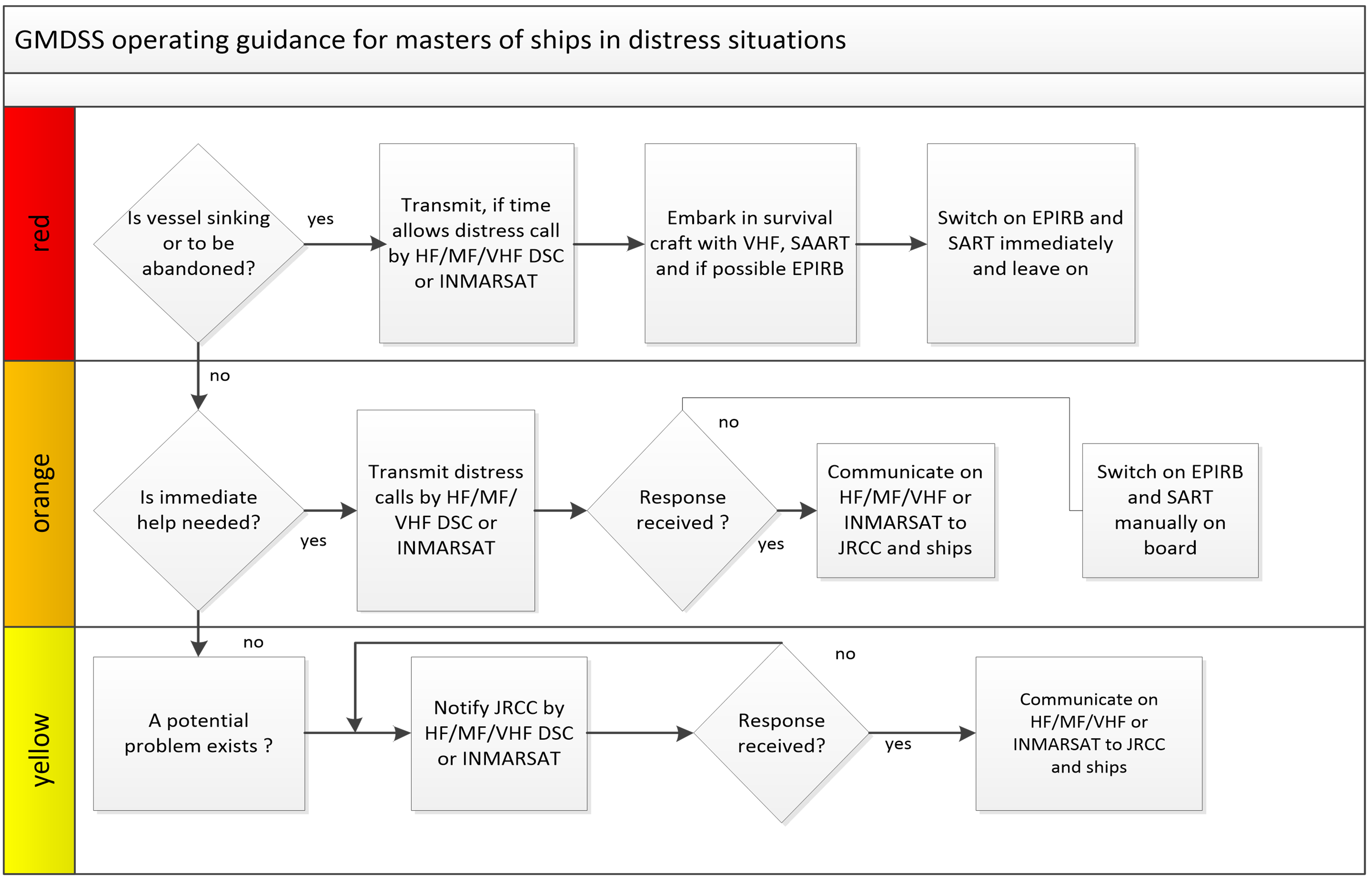
1.EPIRB should float-free and activate automatically if it cannot be taken into survival craft.
2.Where necessary, ships should use any appropriate means to alert other ships.
3.Nothing above is intended to preclude the use of any and all available means of distress alerting.
Page 4-28
AMEND :
Figure 4-8 - Operation Guidance for Masters of Ships in Distress or Urgency Situations
TO READ:
Figure 4-7 - Operation Guidance for Masters of Ships in Distress or Urgency Situations
Page 4-29
AMEND :
Figure 4-9 - Operation Guidance for Masters of Ships Observing Another Vessel Apparently in Danger
TO READ:
Figure 4-8 - Operation Guidance for Masters of Ships Observing Another Vessel Apparently in Danger
Page 4-33
AMEND:
Figure 4-10 - Flow Diagram 1 (COMSAR/Circ.25)
TO READ:
Figure 4-9 - Flow Diagram 1 (COMSAR/Circ.25)
Page 4-34
AMEND:
Figure 4-11 - Flow Diagram 2 (COMSAR/Circ.25)
TO READ:
Figure 4-10 - Flow Diagram 2 (COMSAR/Circ.25)
Page 4-40
AMEND:
4.2.8Differential Global Positioning System (DGPS)
…
Figure 4-12, Figure 4-13, Figure 4-14, and Figure 4-15 show the nominal coverage from existing Canadian broadcast stations. Users should be aware that coverage is subject to short and long term variations due to environmental and seasonal conditions.
TO READ:
4.2.8Differential Global Positioning System (DGPS)
…
Figure 4-11, Figure 4-12, Figure 4-13, and Figure 4-14 show the nominal coverage from existing Canadian broadcast stations. Users should be aware that coverage is subject to short and long term variations due to environmental and seasonal conditions.
Page 4-42
AMEND:
Figure 4-12 - DGPS Coverage - Atlantic Region
TO READ:
Figure 4-11 - DGPS Coverage - Atlantic Region
Page 4-43
AMEND:
Figure 4-13 - DGPS Coverage – Central Region – St. Lawrence Sector
TO READ:
Figure 4-12 - DGPS Coverage – Central Region – St. Lawrence Sector
Page 4-44
AMEND:
Figure 4-14 - DGPS Coverage - Central Region – Great Lakes Sector
TO READ:
Figure 4-13 - DGPS Coverage - Central Region – Great Lakes Sector
Page 4-45
AMEND:
Figure 4-15 - DGPS Coverage - Western Region
TO READ:
Figure 4-14 - DGPS Coverage - Western Region
Page 4-52
AMEND:
Figure 4-16 - Individual NAVTEX Transmitters – Coverage
and Service Areas
Figure 4-16 a) Digby Island
TO READ:
Figure 4-15 - Individual NAVTEX Transmitters – Coverage
and Service Areas
Figure 4-15 a) Digby Island
Page 4-53
AMEND:
Figure 4-16 b) Amphitrite Point
TO READ:
Figure 4-15 b) Amphitrite Point
Page 4-54
AMEND:
Figure 4-16 c) Pass Lake
TO READ:
Figure 4-15 c) Pass Lake
Page 4-55
AMEND:
Figure 4-16 d) Ferndale
O READ:
Figure 4-15 d) Ferndale
Page 4-56
AMEND:
Figure 4-16 e) Moisie
TO READ:
Figure 4-15 e) Moisie
Page 4-57
AMEND:
Figure 4-16 f) Chebogue
TO READ:
Figure 4-15 f) Chebogue
Page 4-58
AMEND:
Figure 4-16 g) Port Caledonia
TO READ:
Figure 4-15 g) Port Caledonia
Page 4-59
AMEND:
Figure 4-16 h) Robin Hood Bay
TO READ:
Figure 4-15 h) Robin Hood Bay
Page 4-60
AMEND:
Figure 4-16 i) Cartwright
TO READ:
Figure 4-15 i) Cartwright
Page 4-61
AMEND:
Figure 4-16 j) Iqaluit
TO READ:
Figure 4-15 j) Iqaluit
Page 4-62
AMEND:
Figure 4-17 - Regional NAVTEX Overview – Coverage and
Service Areas
Figure 4-17 a) Western Region
TO READ:
Figure 4-16 - Regional NAVTEX Overview – Coverage and
Service Areas
Figure 4-16 a) Western Region
Page 4-63
AMEND:
Figure 4-17 b) Great Lakes Region
TO READ:
Figure 4-16 b) Great Lakes Region
Page 4-64
AMEND:
Figure 4-17 c) Gulf of St. Lawrence and Atlantic Region
TO READ:
Figure 4-16 c) Gulf of St. Lawrence and Atlantic Region
Page 4-64
AMEND:
Figure 4-17 d) Atlantic Region: Newfoundland and Labrador
TO READ:
Figure 4-16 d) Atlantic Region: Newfoundland and Labrador
Page 4-65
AMEND:
Figure 4-17 e) Arctic Region
TO READ:
Figure 4-16 e) Arctic Region
Page 4-66
AMEND:
Figure 4-18 - Canadian NAVAREA Zones and Broadcast Areas
TO READ:
Figure 4-17 - Canadian NAVAREA Zones and Broadcast Areas
Page 4-70
AMEND:
Figure 4-19 - World-Wide Navigational Warning Service - NAVAREAs
TO READ:
Figure 4-19 - World-Wide Navigational Warning Service – NAVAREAs
Page 4-78
AMEND LINK:
4.3.11 Inspection of Radio Apparatus
…
Applications for radio inspections of Non-Delegated Canadian ships should be filed with the Canadian Coast Guard. The form entitled: Application for Radio Inspection, Compulsory Fitted Ships (FP-5286-E) should be used for this purpose. Such request by owners, agents or masters should be received by the Canadian Coast Guard at least three working days in advance of the date requested for inspection.
SECTION 4 - CANADIAN SAILING DIRECTIONS CORRECTIONS
The following Canadian Sailing Directions volumes have recently been updated on the Canadian Hydrographic Service website.
|
No. |
Title |
|
Atlantic Coast |
|
|
ATL101 |
Newfoundland, Northeast and East Coasts |
|
ATL102 |
Newfoundland, East and South Coasts |
|
ATL103 |
Newfoundland, Southwest Coast |
|
ATL105 |
Cape Canso to Cape Sable (including Sable Island) |
|
ATL108 |
Gulf of St. Lawrence (Southwest Portion) |
|
ATL109 |
Gulf of St. Lawrence (Northeast Portion) |
|
ATL111 |
St. Lawrence River, Île Verte to Québec and Fjord du Saguenay |
|
ATL112 |
St. Lawrence River, Cap-Rouge to Montréal and Rivière Richelieu |
|
ATL120 |
Labrador, Camp Islands to Hamilton Inlet (including Lake Melville) |
|
Pacific Coast |
|
|
PAC200 |
General Information, Pacific Coast |
|
PAC201 |
Juan de Fuca Strait and Strait of Georgia |
Each volume includes a section entitled “Record of Changes” which lists all updates that are incorporated during the current calendar year.
SECTION 5 - LIST OF LIGHTS, BUOYS AND FOG SIGNALS CORRECTIONS
The amendments are highlighted and deletions are crossed out. For general and region-specific
information on the List of Lights, click on the following links:
Newfoundland and Labrador Coast,
Atlantic Coast,
Inland Waters and
Pacific Coast.
NEWFOUNDLAND AND LABRADOR COAST
| No. | Name |
Position ----- Latitude N. Longitude W. |
Light Characteristics |
Focal Height in m. above water |
Nominal Range |
Description ----- Height in meters above ground |
Remarks ----- Fog Signals |
|||
|---|---|---|---|---|---|---|---|---|---|---|
NOTRE DAME BAY (LL 326 – 346.36, 354 – 395) |
||||||||||
|
364.8 H0623.5 |
Gappy Island Light |
49 46 31.5 054 16 43.8 |
Fl | W | 3s | 24.2 | 5 |
Square skeleton tower, red and white rectangular
daymark. 4.3 |
Flash 1 s; eclipse
2 s. Seasonal. Chart:4820 Edn 06/22 (N22-061) |
|
ATLANTIC COAST
| No. | Name |
Position ----- Latitude N. Longitude W. |
Light Characteristics |
Focal Height in m. above water |
Nominal Range |
Description ----- Height in meters above ground |
Remarks ----- Fog Signals |
|||
|---|---|---|---|---|---|---|---|---|---|---|
CAPE BRETON ISLAND, N.S. (LL 704.85 – 882.5) |
||||||||||
|
719.1 H3401 |
Cowley Point Breakwater |
W. side of inlet, on end of breakwater. 45 30 06.3 060 57 47.5 |
Fl | G | 4s | 4.9 | 4 |
Cylindrical mast, 3.8 |
Flash 1 s; eclipse 3 s. Chart:4308 Edn 06/22 (G22-029) |
|
GULF OF ST. LAWRENCE (LL 1169.1 – 1426, 1477.5 – 1584) |
||||||||||
| 1238.13 | Tabusintac light buoy TA6 |
47 18 27.2 064 55 45.0 |
Q | R | 1s | ….. | ….. | Red spar, marked “TA6”. |
Buoy may be repositioned due to shifting channel. Seasonal. Chart:N/A Edn 06/22 (G22-030) |
|
| 1239.12 | Tabusintac light buoy TA5 |
47 18
28.2 064 55 48.7 |
Q | G | 1s | ….. | ….. | Green spar, marked “TA5”. |
Seasonal. Chart:N/A Edn 06/22 (G22-031) |
|
|
1246.8 H1526.4 |
Pokemouche Gully Wharf |
On SW. corner. 47 40 20.3 064 48 42.9 |
Fl | R | 4s | 5.7 | 4 | Pipe swing pole, red and white triangular daymark. |
Seasonal. Chart:N/A Edn 06/22 (G22-028) |
|
|
1319.1 H1584 |
Young Wharf West |
On NW. corner of wharf. 47 47 51.3 064 55 46.7 |
LFl | G | 6s | 5.4 | 8 |
Pipe swing
pole. 4.9 |
Flash 2 s; eclipse
4 s. Seasonal. Chart:4920 Edn 06/22 (G22-025) |
|
|
1417.4 H1752.2 |
|
At marina
entrance, on N. breakwater. 48 49 40.5 064 28 26.5 |
Fl | R | 2s | 7.0 | 3 |
Red and white square skeleton tower. 5.0 |
Private aid. Privately maintained by Club nautique Jacques-Cartier de Gaspé. Seasonal. Chart:4416 Edn 06/22 (Q21-043) |
|
|
1417.5 H1752.4 |
|
At marina entrance,
on S. pier. 48 49 39.3 064 28 28.7 |
Fl | G | 2s | 7.0 | ….. |
Red and white square skeleton tower. 5.0 |
Flash 0.5 s;
eclipse 1.5
s. Private Aid. Privately maintained by Club nautique Jacques-Cartier de Gaspé. Seasonal. Chart:4416 Edn 06/22 (Q21-044) |
|
|
1483 1484H888 H888.1 |
Grande Entrée range |
Delete from
list.
Delete from
list.Chart:4954 Edn 06/22 (Q20-020, Q21-049) |
||||||||
| 1483.5 | Grande-Entrée |
Les
Îles-de-la-Madeleine. 47 33 20.9 061 33 41.7 |
F |
R W G |
….. | 8.0 | 12 |
Skeleton tower, red
and white rectangular daymark. 6.3 |
Visible on an arc
of 3°. Red from 26.7° to 27.7°; white from 27.7° to 28.7°; green from 28.7° to 29.7°. Operates 24 h. Year round. Chart:4954 Edn 06/22 (Q21-051) |
|
| 1500.3 | Banc Bradelle Scientific light buoy IML-16 |
47 25
55.2 062 33 18.6 |
Fl(5) | Y | 20s | ….. | ….. | Yellow ODAS, marked “IML-16”. |
Seasonal. Chart:4024 Edn 06/22 (Q22-007) |
|
| 1502.2 | Havre Aubert light buoy YK5 |
Cap
Gridley. 47 14 15.3 061 49 27.1 |
Q | G | 1s | ….. | ….. | Green, marked “YK5”. |
(Winter spar.) Seasonal. Chart:4957 Edn 06/22 (Q21-032) |
|
| 1502.7 | Havre Aubert light buoy YK11 |
Cap
Gridley. 47 14 09.6 061 49 32.4 |
Fl | G | 4s | ….. | ….. | Green, marked “YK11”. |
Seasonal. Chart:4957 Edn 06/22 (Q21-030) |
|
| 1503 | Havre Aubert light buoy YK12 |
Cap
Gridley. 47 14 11.2 061 49 33.4 |
Fl | R | 4s | ….. | ….. | Red, marked “YK12”. |
(Winter spar.) Seasonal. Chart:4957 Edn 06/22 (Q21-033) |
|
|
1559.2 H1900.4 |
Île de l’Entrée |
NW. point of island. 50 29 33.5 059 28 08.5 |
Fl | G | 6s | 10.6 | 6 |
Square skeleton tower. 6.6 |
Flash 1 s; eclipse 5 s. Year round. Chart:4468 Edn 06/22 (Q21-048) |
|
ST. LAWRENCE RIVER (LL 1584.5 – 1772, 1823.8 – 2185.7, 2273 – 2365.95) |
||||||||||
|
1663.7 H1994.6 1663.71 H1994.61 |
Sept-Îles, Iron Ore range No. 2 |
| | | | | | | | | | | | | | |
50 11 20.3 066 22 14.8 N. of Pointe aux Basques. 121°48' 495.8 m from front. |
Iso
Iso |
Y
Y |
4s
4s |
13.6
25.3 |
.....
..... |
Mast, orange daymark with black vertical stripe. 12.1 Mast, orange daymark with black vertical stripe. 23.8 |
Private aid. Privately maintained by Iron Ore Company of Canada. Visible in line of range. Operates 24 h. Year round. Private aid. Privately maintained by Iron Ore Company of Canada. Visible in line of range. Operates 24 h. Year round. Chart:1220 Edn 06/22 (Q22-018, 019) |
|
1664 H1994 1665 H1994.1 |
Sept-Îles, Iron Ore range |
| | | | | | | | | | | | | | |
Dock no.
5. 50 11 41.8 066 22 35.3 097°41' 280.2 m from front. |
Iso
Iso |
G
G |
4s
4s |
19.1
34.6 |
.....
..... |
Cylindrical mast, orange daymark with black
vertical stripe. 17.7 Cylindrical mast, orange daymark with black vertical stripe. 33.2 |
Private
aid. Privately maintained by Iron Ore Company of Canada. Visible in line of range. Operates 24 h. Year round. Private aid. Privately maintained by Iron Ore Company of Canada. Visible in line of range. Operates 24 h. Year round. Chart:1220 Edn 06/22 (Q22-015, 016) |
|
1698 H2032 |
Le Gros
Méchins |
On NE.
dolphin. 49 00 26.8 066 58 27.4 |
Fl | Y | 4s | 6.1 | 5 |
Square skeleton tower. 6.6 |
Private aid. Privately maintained by Verreault Navigation Inc. Seasonal. Chart:1230 Edn 06/22 (Q22-006) |
|
|
2067 2068H2390 H2390.1 |
Route de Lottinville range |
| | | | | | | | | | | |
Pointe
Lottinville. 037°31' 975.2 m from front.
46 23 36.1 072 27 44.5 |
F
F
|
G
G
|
.....
.....
|
18.6
33.1
|
13
13
|
Square skeleton tower, orange slatwork daymark
with black
vertical stripe. Skeleton tower, orange slatwork daymark with black vertical
stripe.
23.1 |
Emergency mode.
Emergency mode.Visible in line of range. Operates 24 h. Year round. Visible in line of range. Operates 24 h. Year round. Chart:1313 Edn 06/22 (Q22-020, 021) |
|
2080 2081H2388 H2388.1 |
Cap-de-la-Madeleine Wharf range |
| | | | | | | | | | | |
On SW. corner of wharf. 242°37' 147.0 m from front.
46 21 56.4 072 29 50.9 |
F
F
|
G
G
|
.....
.....
|
10.3
19.9
|
11
11
|
Green
square Square skeleton tower, orange slatwork daymark
with black
vertical stripe.
12.8 |
Emergency mode. Emergency mode.Visible in line of range. Operates 24 h. Year round. Visible in line of range. Operates 24 h. Year round. Chart:1313 Edn 06/22 (Q22-009, 010) |
|
2319 2320H2476 H2476.1 |
Verchères Village range |
| | | | | | | | | | | |
45 46 46.0 073 21 22.4 |
F
F
|
G
G
|
.....
.....
|
10.0
30.8
|
16
16
|
Skeleton
tower, fluorescent red
daymark with black vertical stripe. 6.0 24.5 |
Emergency mode.
Emergency mode.Visible in line of range. Operates 24 h. Year round. Visible in line of range. Operates 24 h. Year round. Chart:1311 Edn 06/22 (Q21-058, 059) |
SAGUENAY RIVER (LL 1773 – 1823.4) |
||||||||||
| 1774 | Haut-fond Prince light and bell buoy SAGUE |
Delete from
list. Chart:1203 Edn 06/22 (Q22-004) |
||||||||
Report a problem on this page
- Date modified: