

Notices to Mariners
February 27, 2026

Safety First, Service Always
Monthly Eastern Edition
CONTENTS
| Section 1 | General and Safety Information |
| Section 1A | Temporary and Preliminary Notices |
| Section 2 | Chart Corrections |
| Section 3 | Radio Aids to Marine Navigation Corrections |
| Section 4 | Canadian Sailing Directions Corrections |
| Section 5 | List of Lights, Buoys and Fog Signals Corrections |
Notices to Mariners – Monthly Eastern Edition
Edition No. 02/2026
Aussi disponible en français :
Avis aux navigateurs – Édition mensuelle de l’Est
Édition n° 02/2026
Published under the Authority of:
Canadian Coast Guard Programs
Aids to Navigation and Waterways
Montreal, QC H2Y 2E7
For more information, contact DFO.Notmar-Notmar.MPO@dfo-mpo.gc.ca.
© His Majesty the King in Right of Canada,
as represented by the Canadian Coast Guard, 2026.
Cat. No. Fs152-8E-PDF (Electronic PDF, English)
ISSN 2817-0075
Cat. No. Fs152-8F-PDF (Electronic PDF, French)
ISSN 2817-0083

Explanatory Notes – Notices to Mariners (NOTMAR)
Geographical positions refer directly to the graduations of the largest scale Canadian Hydrographic Service chart (unless otherwise indicated).
Bearings refer to the true compass and are measured clockwise from 000° (North) clockwise to 359°; those relating to lights are from seaward.
Visibility of lights is that in clear weather.
Depths - The units used for soundings (metres, fathoms or feet) are stated in the title of each chart.
Elevations are normally given above Higher High Water, Large Tide (unless otherwise indicated).
Distances may be calculated as follows:
1 nautical mile = 1,852 metres (6,076.1 feet)
1 statute mile = 1,609.3 metres (5,280 feet)
1 metre = 3.28 feet
Temporary and Preliminary Notices to Mariners – Section 1A of Notices to Mariners
These notices are indicated by a (T) or a (P), respectively. Please note that nautical charts are not amended by the Canadian Hydrographic Service for temporary (T) and preliminary (P) notices. It is recommended that mariners chart these corrections in pencil. For the list of charts affected by (T) & (P) notices, please refer to the current Notices to Mariners - Monthly Summary of Temporary and Preliminary Notices publication.
Suggestions and Corrections Form
This form is specifically for suggestions and corrections to Notices to Mariners publications. It is available online and also in fillable PDF format included with the monthly publication ZIP file.
To submit comments and suggestions on possible improvements to the various publications and services: DFO.Notmar-Notmar.MPO@dfo-mpo.gc.ca.
To report chart discrepancies and/or corrections to the Canadian Sailing Directions booklets: Fill out the Marine Information Reporting Form and/or email chsinfo@dfo-mpo.gc.ca.
To report emergencies or navigational hazards: Contact your nearest MCTS centre
- VHF channel 16 (156.8 MHz)
- MF/HF frequency 2182 kHz/4125 kHz (where available)
- ∗16 on a cellphone (where available)
NOTMAR Website – Monthly Editions, Chart Corrections and Chart Patches
The NOTMAR website allows users to access the monthly publications,
chart corrections, and chart patches.
Users can subscribe for free to the email notification service
to receive notifications when charts of interest are updated, including their patches, as well as when a new Monthly Edition of Notices to Mariners is published.
In addition, the monthly publication and related
files to download, such as chart patches, can be obtained
all together through the download of a single ZIP file.
Explanatory Notes – Canadian Hydrographic Service (CHS)
Chart Corrections – Section 2 of Notices to Mariners
Corrections to nautical charts will be listed in numerical order by chart number. Each chart correction listed applies only to that particular chart. Related charts, if any, will have their own specific correction listed separately.
Users should also refer to CHS Chart 1: Symbols, Abbreviations and Terms for additional information pertaining to the correction of charts.
The illustration below describes the elements that will comprise a typical Section 2 chart correction:

The last correction number is identified with the LNM/D or Last Notice to Mariners Number / Date.
Mariners are advised that only the most critical changes that directly affect safety to navigation are issued in “Section 2 – Chart Corrections.” This limitation is required to ensure that charts remain as clear and easy to read as possible. As a result, mariners may see minor discrepancies of a non-critical nature between information in official publications. For example, a small change in the nominal range or focal height of a light may not result in the production of a chart correction in Notices to Mariners, but may result in a correction in the List of Lights, Buoys and Fog Signals publication.
Note: In the case of a discrepancy between information provided on CHS charts relating to aids to navigation, and the List of Lights, Buoys and Fog Signals publication, the latter shall be deemed as containing the most up-to-date information.
Explanatory Notes – Marine Communications and Traffic Services (MCTS)
Navigational Warnings / Notices to Shipping
The Canadian Coast Guard (CCG) is implementing a number of changes to the aids to navigation system in Canada.
These changes are advertised as Navigational Warnings, formerly called Notices to ShippingFootnote 1, that are broadcast by the CCG, and are then followed up with Notices to Mariners, then charts are updated by hand correction, reprints or new editions.
Mariners are advised that all relevant Navigational Warnings (NAVWARN) should be kept until superseded by Notices to Mariners or through revised charts issued by the Canadian Hydrographic Service (CHS).
NAVWARN are accessible on the applicable regional page on the CCG Navigational Warnings.
CHS is reviewing the impact of these changes with CCG and together are preparing an action plan on the issuing of chart revisions.
For further information, contact your regional NAVWARN Issuing Desk.
Atlantic Region (North)
* Port aux Basques MCTS Centre
“N” Series NAVWARN
Canadian Coast Guard
49 Stadium Rd.
P.O. Box 99
Port aux Basques, NL A0M 1C0
Telephone: 709-695-2168 or 1-800-563-9089
Facsimile: 709-695-7784
Email: NAVWARN.MCTSPortAuxBasques@innav.gc.ca
Central Region
* Prescott MCTS Centre
“C” Series NAVWARN
Canadian Coast Guard
401 King Street West
P.O. Box 1000
Prescott, ON K0E 1T0
Telephone: 613-925-0666
Facsimile: 613-925-4519
Email: NAVWARN.MCTSPrescott@innav.gc.ca
Atlantic Region (South)
* Sydney MCTS Centre
“M” Series NAVWARN
Canadian Coast Guard
1190 Westmount Road
Sydney, NS B1R 2J6
Telephone: 902-564-7751 or 1-800-686-8676
Facsimile: 902-564-7662
Email: NAVWARN.MCTSSydney@innav.gc.ca
Arctic Region
* Iqaluit MCTS Centre
Operational from approximately mid-May until late December.
“A” Series NAVWARN
Canadian Coast Guard
P.O. Box 189
Iqaluit, NU X0A 0H0
Telephone: 867-979-5269
Facsimile: 867-979-4264
Email: NAVWARN.MCTSIqaluit@innav.gc.ca
* Service available in English and French.
Index
Numerical Index of Canadian Charts Affected
This numerical index lists all nautical charts mentioned in this monthly edition of Notices to Mariners. Only charts appearing in Section 2 of this publication require a chart correction. The appearance of charts in all other sections, particularly those related to the correction of other nautical publications, is included here for reference.
| 1221 | 2181 | 4240 | 4486 |
| 1234 | 2250 | 4242 | 4653 |
| 1312 | 4003 | 4244 | 4679 |
| 1316 | 4012 | 4266 | 4920 |
| 1317 | 4015 | 4363 | 4921 |
| 1350 | 4022 | 4365 | 5620 |
| 1360 | 4024 | 4367 | 6417 |
| 1434 | 4170 | 4379 | 6424 |
| 1552 | 4209 | 4384 | 6425 |
| 1554 | 4211 | 4459 | |
| 2140 | 4233 | 4485 |
SECTION 1 - GENERAL AND SAFETY INFORMATION
*505/23Canadian Hydrographic Service – Magnetic Declination Calculations
(Recurrent publication of notice *505/23, originally published in the Notices to Mariners – Monthly Eastern Edition 05/2023 publication.)
Mariners are advised that CHS has adopted the harmonized World Magnetic Model (WMM), as found on the NCEI/NOAA website. Old compass rose declination information on CHS navigational products can be updated using this website: https://www.ngdc.noaa.gov/geomag/calculators/magcalc.shtml#declination. While the differences in the model declinations are small each year, they can become more significant over a large period of time.
*1207/23Canadian Hydrographic Service – Inappropriate Geographical Names Review Process
(Recurrent publication of notice *1207/23, originally published in the Notices to Mariners – Monthly Eastern Edition 12/2023 publication.)
The records of the Canadian Hydrographic Service could contain geographical names that may be considered inappropriate, offensive and derogatory. Geographical naming authorities are in the process of addressing many offensive place names, the review process is underway. For more information, about inappropriate geographical names, please see the following announcement.
*1001/25Pilot Project – Guidelines for the Transit of Container Vessels up to 310 metres in Length x 40 metres in Beam – Québec–Montréal Segment
(Recurrent publication of notice *1001/25, originally published in the Notices to Mariners – Monthly Eastern Edition 10/2025 publication.)
NOTICE
This notice sets out the conditions under which container ships, with a maximum length of 310 metres and a beam of up to 40 metres, may safely transit the St. Lawrence waterway between Québec and Montréal.
Effective Date: September 30, 2025
Duration: This pilot project remains in effect until further notice or until permanent guidelines are established.
Scope of the Pilot Project
This pilot project applies to container vessels with following dimensions:
Length Overall: Between 300.01 metres and not exceeding 310.0 metres; and,
Moulded Breadth: Equal to or greater than 32.5 metres, not exceeding 40.0 metres.
Application of Notice to Mariners 27A
Notice to Mariners 27A remains applicable, except for the following sections, which are amended or replaced by the directives specified in this pilot project:
Section 2: Meetings in Risk Areas (R)
Section 3: Overtaking in Risk Areas (D)
Section 6: Maneuverability Assessment
Note: Any changes in the status of the vessel (e.g. hull, navigational equipment, propulsion, etc.) must be reported immediately to the Escoumins Marine Communication and Traffic Services Centre (MCTS Escoumins) prior to entering pilotage area.
Should a deficiency occur, it will be analyzed and reviewed by Canadian Coast Guard, Pilotage Authority and Transport Canada to determine steps to resolve the issue. A reauthorization will be required to proceed into pilotage areas as a vessel participating in a pilot project.
Specific Guidelines – Container Ships up to 310 m x 40 m
1. Meetings and Overtaking
All meetings and overtaking are permitted in accordance with
Notice 27A for all vessels, except for Wide Beam and Long
vessels.
For these vessels, the authorized zones for meeting and overtaking with vessel up to 310 m x 40m will be determined by the expert committee and communicated to MCTS within 48-hours prior to the transit, based on scheduled traffic of other Wide Beam and Long vessels.
2. Transit Safety Conditions and Measures
2.1 Transits will mostly occur during daylight between Québec and Montréal, depending on weather, traffic, and other navigational risk factors.
2.1.1 During hours of darkness, in favourable
conditions, passage is allowed for upbound container vessels
until Grondines.
2.1.2 The “Good Manoeuvrability” (BM)
classification, as defined in Sections 6 and 7 of Notice 27A,
cannot be assigned to the vessels covered by this pilot
project.
2.2 Minimum engine speed is required when approaching the Québec bridges and the Laviolette Bridge, provided environmental conditions allow.
2.3 Maximum speed over ground between
Île-aux-Vaches and Contrecoeur is 9 knots upbound and 11 knots
downbound.
2.4 During pilot changeovers at
Trois-Rivières, the handover of conduct shall take place,
upstream or downstream after the vessel has cleared the
Laviolette Bridge, weather conditions permitting.
2.5 At least 30 minutes before passing under
the Québec bridges and the Laviolette Bridge, qualified crew
members must be stationed:
•In the steering gear room, ready to activate emergency steering systems; and,
•On the forecastle, ready to drop anchors.
Each station must be equipped with independent communication means with the bridge.
2.6 An operational tug with a minimum bollard pull of 40 tonnes must be assigned and available during the vessel’s transit under the Laviolette Bridge. The tug must:
•Be within a 15-nautical-mile radius of the Laviolette Bridge;
•Ready to respond within one hour’s notice
Passage Management Framework
1. Coordination and Follow-up Procedures
Any shipowner or agent planning a transit under this pilot
project must notify the Laurentian Pilotage Authority (LPA)
at transit@apl.gc.ca
as soon as possible, and at least 10 days in advance.
2. Expert Committee
The expert committee responsible for monitoring this pilot
project consists of representatives from:
•Canadian Coast Guard (CCG)
•Corporation of Central St. Lawrence Pilots
(CPSLC)
•Laurentian Pilotage Authority (LPA)
•Montreal Port Authority (MPA)
•Transport Canada (TC)
Roles and Responsibilities:
•Pre-transit assessment: Hold a
meeting before each transit to analyze environmental,
operational, and safety conditions.
•Transit Planning: Coordinate vessel
arrival and ensure measures are implemented.
•Transit monitoring: Oversee and
study each transit
•Decision-making: Authorize or
postpone passage based on observed conditions and evaluated
risks.
3. Operational Flexibility
The expert committee may:
•Ease, reinforce, or modify safety measures based on weather, tides, or other risk factors.
•Place representatives on board for study and verification purposes within the pilot project.
Safety and Responsibility Clause
In applying these guidelines, it is understood that the pilot and bridge team must take into account all navigational hazards, collision risks, and special circumstances, as well as vessel limitations, which may require deviation from these measures to avoid immediate danger.
In such cases of deviation, or in any incident or situation,
the pilot must inform the nearest MCTS officer.
The pilot conducting the vessel is responsible to the master
for the safety navigation of the vessel.
(Section
38.01(3) of the Pilotage Act)
Pilot Project Progress
As part of this pilot project, safety measures will be continuously monitored and may be progressively adjusted by the expert committee based on:
•Operational experience acquired during transits under
varied conditions;
•Results of complementary technical studies;
•Assessment of the potential impact on traffic
fluidity; and,
•Recommendations made by the expert committee.
Any adjustment must be submitted to the Standing Committee on Navigational Safety (SCNS) for review and, if required, communicated through additional notices.
Reporting and Data Collection
After each voyage, pilots must submit to the expert committee a detailed report on vessel maneuverability and on meetings that occurred during the passage. MCTS will also submit a transit report.
The Laurentian Pilotage Authority will maintain a consolidated database of all transit and maneuverability reports related to this pilot project.
Contact Information
Laurentian Pilotage Authority
Phone: 514-657-2041 option 2
Email: transit@apl.gc.ca
*201/26Canadian Hydrographic Service – Electronic Navigational Charts
|
S-57 & S-101 ENC Number |
Chart Title |
Published |
|
|
New Charts |
|||
|
CA546RFA (Edn 1.000) |
Louisbourg Harbour |
2026-01-16 |
|
|
CA547RFA (Edn 1.000) |
Louisbourg Harbour |
2026-01-16 |
|
|
CA571258 (Edn 1.000) |
Bamfield Inlet |
2026-02-13 |
|
|
New Editions |
|||
|
101CA00P454N0735W (Edn 4.000) |
101CA00P454N0735W |
2026-01-30 |
|
|
101CA00P454N0736W (Edn 4.000) |
101CA00P454N0736W |
2026-01-30 |
|
|
101CA00P454N0737W (Edn 4.000) |
101CA00P454N0737W |
2026-01-30 |
|
|
101CA00P454N0738W (Edn 6.000) |
101CA00P454N0738W |
2026-01-30 |
|
|
101CA00P455N0735W (Edn 5.000) |
101CA00P455N0735W |
2026-01-30 |
|
|
101CA00P455N0736W (Edn 4.000) |
101CA00P455N0736W |
2026-01-30 |
|
|
101CA00P456N0735W (Edn 4.000) |
101CA00P456N0735W |
2026-01-30 |
|
|
101CA00P456N0736W (Edn 3.000) |
101CA00P456N0736W |
2026-01-30 |
|
|
101CA00P457N0734W (Edn 3.000) |
101CA00P457N0734W |
2026-01-30 |
|
|
101CA00P457N0735W (Edn 3.000) |
101CA00P457N0735W |
2026-01-30 |
|
|
101CA00P457N0736W (Edn 3.000) |
101CA00P457N0736W |
2026-01-30 |
|
|
101CA00P458N0733W (Edn 3.000) |
101CA00P458N0733W |
2026-01-17 |
|
|
101CA00P458N0734W (Edn 3.000) |
101CA00P458N0734W |
2026-01-30 |
|
|
101CA00P459N0732W (Edn 3.000) |
101CA00P459N0732W |
2026-01-30 |
|
|
101CA00P460N0731W (Edn 3.000) |
101CA00P460N0731W |
2026-01-30 |
|
|
101CA00P460N0732W (Edn 4.000) |
101CA00P460N0732W |
2026-01-30 |
|
|
101CA00P462N0727W (Edn 3.000) |
101CA00P462N0727W |
2026-01-30 |
|
|
101CA00P463N0724W (Edn 3.000) |
101CA00P463N0724W |
2026-01-30 |
|
|
101CA00P463N0725W (Edn 3.000) |
101CA00P463N0725W |
2026-01-30 |
|
|
101CA00P463N0726W (Edn 3.000) |
101CA00P463N0726W |
2026-01-30 |
|
|
101CA00P464N0724W (Edn 3.000) |
101CA00P464N0724W |
2026-01-30 |
|
|
101CA00P465N0722W (Edn 3.000) |
101CA00P465N0722W |
2026-01-30 |
|
|
101CA00P466N0716W (Edn 3.000) |
101CA00P466N0716W |
2026-01-30 |
|
|
101CA00P466N0719W |
2026-01-30 |
||
|
101CA00P467N0712W (Edn 3.000) |
101CA00P467N0712W |
2026-01-30 |
|
|
101CA00P467N0713W (Edn 4.000) |
101CA00P467N0713W |
2026-01-30 |
|
|
101CA00P467N0714W (Edn 3.000) |
101CA00P467N0714W |
2026-01-30 |
|
|
101CA00P468N0712W (Edn 3.000) |
101CA00P468N0712W |
2026-01-30 |
|
|
101CA00T450N0740W (Edn 4.000) |
101CA00T450N0740W |
2026-01-31 |
|
|
101CA00T460N0710W (Edn 5.000) |
101CA00T460N0710W |
2026-01-30 |
|
|
101CA00T460N0720W (Edn 6.000) |
101CA00T460N0720W |
2026-01-31 |
|
|
101CA00T460N0720W (Edn 7.000) |
101CA00T460N0720W |
2026-01-30 |
|
|
101CA00T460N0730W (Edn 6.000) |
101CA00T460N0730W |
2026-01-30 |
|
|
101CA00T460N0740W (Edn 5.000) |
101CA00T460N0740W |
2026-01-31 |
|
|
101CA00T460N0740W (Edn 6.000) |
101CA00T460N0740W |
2026-01-30 |
|
|
101CA00T470N0710W (Edn 6.000) |
101CA00T470N0710W |
2026-01-17 |
|
|
CA217P1A (Edn 3.000) |
CA217P1A |
2026-01-23 |
|
|
CA217Q8A (Edn 2.000) |
CA217Q8A |
2026-01-23 |
|
|
CA217RFA (Edn 2.000) |
CA217RFA |
2026-01-23 |
|
|
CA217SNA (Edn 2.000) |
CA217SNA |
2026-01-23 |
|
|
CA217TVA (Edn 2.000) |
CA217TVA |
2026-01-23 |
|
|
CA217V3A (Edn 2.000) |
CA217V3A |
2026-01-23 |
|
|
CA217WAA (Edn 2.000) |
CA217WAA |
2026-01-23 |
|
|
CA22EQ8A (Edn 2.000) |
CA22EQ8A |
2026-01-23 |
|
|
CA22ERFA (Edn 2.000) |
CA22ERFA |
2026-01-23 |
|
|
CA22ESNA (Edn 2.000) |
CA22ESNA |
2026-01-23 |
|
|
CA22ETVA (Edn 2.000) |
CA22ETVA |
2026-01-23 |
|
|
CA22EV3A (Edn 2.000) |
CA22EV3A |
2026-01-23 |
|
|
CA22EWAA (Edn 2.000) |
CA22EWAA |
2026-01-23 |
|
|
CA23MP1B (Edn 2.000) |
CA23MP1B |
2026-01-23 |
|
|
CA23MQ8B (Edn 2.000) |
CA23MQ8B |
2026-01-23 |
|
|
CA23MRFA (Edn 2.000) |
CA23MRFA |
2026-01-16 |
|
|
CA23MSNA (Edn 2.000) |
CA23MSNA |
2026-01-23 |
|
|
CA24UMTA (Edn 2.000) |
Overview4800N07200W |
2026-02-20 |
|
|
CA24UQ8A (Edn 3.000) |
Overview4800N06400W |
2026-02-20 |
|
|
CA24URFA (Edn 2.000) |
Overview4800N06000W |
2026-02-20 |
|
|
CA24UV3A (Edn 2.000) |
CA24UV3A |
2026-01-23 |
|
|
CA24UWAA (Edn 2.000) |
CA24UWAA |
2026-01-23 |
|
|
CA24UXHA (Edn 2.000) |
CA24UXHA |
2026-01-23 |
|
|
CA24UYQA (Edn 2.000) |
CA24UYQA |
2026-01-23 |
|
|
CA262RFA (Edn 2.000) |
CA262RFA |
2026-01-23 |
|
|
CA262SNA (Edn 4.000) |
CA262SNA |
2026-02-20 |
|
|
CA262TVA (Edn 2.000) |
CA262TVA |
2026-01-23 |
|
|
CA262V3A |
2026-01-23 |
||
|
CA262WAA (Edn 2.000) |
CA262WAA |
2026-01-23 |
|
|
CA262XHA (Edn 2.000) |
CA262XHA |
2026-01-23 |
|
|
CA262YQA (Edn 2.000) |
CA262YQA |
2026-01-23 |
|
|
CA279RFA (Edn 2.000) |
CA279RFA |
2026-01-23 |
|
|
CA279SNA (Edn 2.000) |
CA279SNA |
2026-01-23 |
|
|
CA279TVA (Edn 2.000) |
CA279TVA |
2026-01-23 |
|
|
CA279V3A (Edn 2.000) |
CA279V3A |
2026-01-23 |
|
|
CA279WAA (Edn 2.000) |
CA279WAA |
2026-01-23 |
|
|
CA279XHA (Edn 2.000) |
CA279XHA |
2026-01-23 |
|
|
CA279YQA (Edn 2.000) |
CA279YQA |
2026-01-23 |
|
|
CA43MMHA (Edn 3.000) |
Transit4400N07300W |
2026-02-20 |
|
|
CA43MPXA (Edn 2.000) |
CA43MPXA |
2026-01-23 |
|
|
CA43MPXB (Edn 2.000) |
CA43MPXB |
2026-01-23 |
|
|
CA43MQ8A (Edn 2.000) |
CA43MQ8A |
2026-01-23 |
|
|
CA43MQ8B (Edn 2.000) |
CA43MQ8B |
2026-01-23 |
|
|
CA43MR5A (Edn 2.000) |
CA43MR5A |
2026-01-16 |
|
|
CA43MRFA (Edn 2.000) |
CA43MRFA |
2026-01-16 |
|
|
CA43MRRA (Edn 2.000) |
CA43MRRA |
2026-01-16 |
|
|
CA43XMHA (Edn 3.000) |
Transit4500N07300W |
2026-02-20 |
|
|
CA43XQ8A (Edn 2.000) |
CA43XQ8A |
2026-01-16 |
|
|
CA43XQJA (Edn 2.000) |
CA43XQJA |
2026-01-16 |
|
|
CA448N4A (Edn 5.000) |
Transit4600N07100W |
2026-02-13 |
|
|
CA471014 (Edn 5.000) |
Hippa Island, Seal Inlet, Tartu Inlet, Masset Inlet |
2026-02-13 |
|
|
CA471017 (Edn 2.000) |
Skidegate Channel, Skidegate Inlet |
2026-02-13 |
|
|
CA471018 (Edn 5.000) |
Dogfish Banks |
2026-02-13 |
|
|
CA471139 (Edn 2.000) |
CA471139 |
2026-02-20 |
|
|
CA471140 (Edn 2.000) |
CA471140 |
2026-02-20 |
|
|
CA471141 (Edn 2.000) |
CA471141 |
2026-02-20 |
|
|
CA471187 (Edn 2.000) |
CA471187 |
2026-02-20 |
|
|
CA471191 (Edn 2.000) |
CA471191 |
2026-02-20 |
|
|
CA471208 (Edn 2.000) |
CA471208 |
2026-02-20 |
|
|
CA471210 (Edn 2.000) |
CA471210 |
2026-02-20 |
|
|
CA471212 (Edn 2.000) |
CA471212 |
2026-02-20 |
|
|
CA471215 (Edn 3.000) |
CA471215 |
2026-02-20 |
|
|
CA479QJA (Edn 2.000) |
CA479QJA |
2026-02-20 |
|
|
CA479QUB (Edn 2.000) |
CA479QUB |
2026-02-20 |
|
|
CA47VQ8A (Edn 2.000) |
CA47VQ8A |
2026-01-23 |
|
|
CA47VQUA (Edn 3.000) |
CA47VQUA |
2026-02-20 |
|
|
CA549RFA (Edn 2.000) |
CA549RFA |
2026-01-23 |
|
|
CA54ARFA |
2026-01-23 |
||
|
CA54UPSA (Edn 3.000) |
Port4800N06550W |
2026-02-06 |
|
|
CA571077 (Edn 5.000) |
CA571077 |
2026-02-20 |
|
|
CA571522 (Edn 2.000) |
CA571522 |
2026-02-20 |
|
|
CA571523 (Edn 2.000) |
CA571523 |
2026-02-20 |
|
|
CA571541 (Edn 3.000) |
CA571541 |
2026-02-20 |
|
|
CA571549 (Edn 2.000) |
CA571549 |
2026-02-20 |
|
|
CA571550 (Edn 2.000) |
CA571550 |
2026-02-20 |
|
|
CA578R4A (Edn 2.000) |
CA578R4A |
2026-02-20 |
|
|
CA57DQTA (Edn 2.000) |
CA57DQTA |
2026-02-20 |
|
|
CA57EQXA (Edn 2.000) |
CA57EQXA |
2026-02-20 |
|
|
CA580QMA (Edn 2.000) |
CA580QMA |
2026-02-20 |
|
|
Charts Permanently Withdrawn |
|||
|
CA22EMTA |
CA22EMTA |
2026-02-06 |
|
|
CA570227 |
Bamfield Inlet |
2026-02-13 |
|
*202/26Canadian Hydrographic Service – Raster Digital Charts (BSB V3)
|
Charts |
Main Title |
Scale |
Edition Date |
Published |
|
|
Charts Permanently Withdrawn |
|||||
|
RM-2293 |
Byng Inlet and Approaches / et les approches |
|
|
||
|
RM-2307 |
Coppermine Point to/à Cape Gargantua |
|
|
||
|
RM-2309 |
Cape Gargantua to/à Otter Head |
|
|
||
|
RM-4114 |
Campobello Island |
|
|
||
|
RM-5351 |
Payne Bay and Approaches |
|
|
||
|
RM-5373 |
Approches à/Approaches to Rivière George |
|
|
||
|
RM-5410 |
Coral Harbour and Approaches/et les approches |
|
|
||
|
RM-5620 |
Entrance to/Entrée à Chesterfield Inlet (Fairway Island to/à Ellis Island) |
|
|
||
|
RM-7125 |
Pike-Resor Channel |
|
|
||
|
RM-7126 |
Culbertson Island to/à Frobisher's Farthest |
|
|
||
|
RM-7127 |
Koojesse Inlet and Approaches/et les Approches |
|
|
||
|
RM-7150 |
Pangnirtung and Approaches/et les approches |
|
|
||
|
RM-7181 |
Durban Harbor |
|
|
||
|
RM-7779 |
Dease Strait |
|
|
||
|
RM-7788 |
Simpson Strait to/a Rasmussen Basin |
|
|
||
*203/26Canadian Coast Guard Publication – Annual Edition of Notices to Mariners 2026
The Annual Edition of Notices to Mariners 2026 is now available for free download, on the NOTMAR website.
Paper copies of this publication are no longer sold. This printable online version is kept up to date.
Amendments to this publication are advertised in Section 1 of the monthly editions of Notices to Mariners.
The 2026 edition has been revised up to February 27, 2026 and supersedes the 2025 edition.
*204/26Canadian Hydrographic Service – S-102 Bathymetric Surface
The Member States of the International Hydrographic Organization (IHO) have adopted the first set of operational standards under the S-100 framework (Edition 5.2.0). Among these, the S-102 standard for Bathymetric Surface Products (Edition 3.0.0) has been officially published.
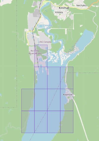
The Canadian Hydrographic Service (CHS) has produced and released its first 12 Level 6 cells (2-meter resolution) of S-102 products for the Canadian west coast in Kitimat Harbour. This milestone represents further advancement in the implementation of the IHO’s S-100 strategy and demonstrates operational capability to deliver next-generation navigational data.
Compliant with IHO Circular Letters and resolutions, this new product enhances navigational safety, supports interoperability with related datasets and strengthens the resilience of maritime information services. This achievement serves as a benchmark for hydrographic offices engaged in the global transition to S-100 standards.
S-102 Level 6 cells (2-meter resolution)
*205/26Canadian Hydrographic Service – Electronic Navigational Charts
The Member States of the International Hydrographic Organization (IHO) have adopted the first set of operational standards under the S-100 framework (Edition 5.2.0). Among these, S-101 standard relating to electronic navigational charts (ENC), edition 2.0.0, has been officially published and came into effect on January 1, 2026.
The Canadian Hydrographic Service (CHS) has produced and released its first 6 S-101 products for the Canadian west coast in Kitimat Harbour. This milestone represents further advancement in the implementation of the IHO’s S-100 strategy and demonstrates operational capability to deliver next-generation navigational data. To this end, S-57 and S-101 electronic charts are carefully synchronized in their respective versions to ensure the “Dual Fuel” concept, enabling a gradual transition to S-100 standards while maintaining operational continuity.
Compliant with IHO Circular Letters and resolutions, this new product enhances navigational safety, supports interoperability with related datasets and strengthens the resilience of maritime information services. This achievement serves as a benchmark for hydrographic offices engaged in the global transition to S-100 standards.
|
NEW S-101 ENCs – Kitimat Harbour |
|
|
101CA00P540N1288Wv2u0 |
101CA00P539N1287Wv2u0 |
|
101CA00P540N1287Wv2u0 |
101CA00P538N1288Wv2u0 |
|
101CA00P539N1288Wv2u0 |
101CA00P538N1287Wv2u0 |
|
NEW S-57 ENCs – Kitimat Harbour |
|
|
CA56N4LAv2u0 |
CA56M4MAv2u0 |
|
CA56N4MAv2u0 |
CA56L4LAv2u0 |
|
CA56M4LAv2u0 |
CA56L4MAv2u0 |
|
ENC Cancellations |
|
|
CA571243v1u0 |
CA571246v1u0 |
|
CA571244v1u0 |
CA571247v1u0 |
|
CA571245v1u1 |
CA571248v1u0 |
*207/26Pointe de Moisie à/to Île du Grand Caoui – DGPS Station Permanently Discontinued
Reference chart: 1221
The following DGPS station has been permanently discontinued:
|
Aid Name |
LL No. |
Position |
|
Moisie West DGPS Station |
6618 |
50° 11’ 42.8”N 066° 06’ 40.7”W |
(Q2026-002)
*208/26Cap de la Tête au Chien au/to Cap aux Oies – DGPS Station Permanently Discontinued
Reference chart: 1234
The following DGPS station has been permanently discontinued:
|
Aid Name |
LL No. |
Position |
|
Rivière-du-Loup DGPS Station |
6828.5 |
47° 45’ 37.0”N 069° 36’ 20.2”W |
(Q2026-003)
*209/26Port de Québec – DGPS Station Permanently Discontinued
Reference chart: 1316
The following DGPS station has been permanently discontinued:
|
Aid Name |
LL No. |
Position |
|
Lauzon East DGPS Station |
6931.6 |
46° 48’ 44.7”N 071° 09’ 33.4”W |
(Q2026-001)
*210/26Portage-du-Fort à/to Île Marcotte – Unlit Buoys Permanently Established
Reference chart: 1552
The following unlit buoys have been permanently established at the following coordinates:
|
Aid Name |
LL No. |
Position |
|
Buoy C42/2 |
7004.267 |
45° 54’ 45.1”N 076° 57’ 46.7”W |
|
Buoy C43/1 |
7004.271 |
45° 54’ 36.2”N 076° 57’ 55.1”W |
(B2026-001, 002)
*212/26Saint-Jean-sur-Richelieu – DGPS Station Permanently Discontinued
Reference chart: N/A
The following DGPS station has been permanently discontinued:
|
Aid Name |
LL No. |
Position |
|
Saint-Jean-sur-Richelieu DGPS Station |
7255.6 |
45° 19’ 16.8”N 073° 18’ 37.2”W |
(Q2026-004)
Reminder – Comment Period for Active Preliminary Notices
This is a reminder that the comment period is still open for the following active Preliminary notices:
|
Notice # |
Reference Chart # |
Aids Affected |
Intent of Notice |
|
Atlantic Coast |
|||
|
4209 |
360.11, 5360.12 |
Notice of Proposed Changes |
|
|
4486 |
1325.1 |
Aid to Navigation to be Discontinued |
|
|
4920 |
1314, 1314.1, 1314.12 |
Notice of Proposed Changes |
|
|
Inland Waters |
|||
|
N/A |
763, 7006 |
Buoys to be Discontinued |
|
|
Other Preliminary Notices |
|||
|
N/A |
N/A |
Navigational Warning (NAVWARN) Issuing System Update |
|
Please refer to the Notices to Mariners - Monthly Summary of Temporary and Preliminary Notices publication for details.
Newfoundland and Labrador Coast
Temporary Notices
No notices applicable for this edition.
Preliminary Notices
No notices applicable for this edition.
Atlantic Coast
Temporary Notices
*213(T)/26Sorel-Tracy à/to Otterburn-Park – Obstruction: Submerged Object
Reference chart: 1350
Anchor with 9 shackles of chain reported in the vicinity of
46° 01.87’N 073° 09.86’W.
(NW-C-1370-24)
|
Comment
Submission |
Comments should be directed to the following: |
*214(P)/26Cape Canso to / à Country Island – Fixed Aid to Navigation to be Discontinued
Reference chart: 4233
The Canadian Coast Guard proposes to permanently discontinue the following fixed aid to navigation equipped with a fog signal:
|
Aid Name |
LL No. |
Position |
|
Walsh Point Fog Signal |
662.5 |
45° 16’ 17.2”N 061° 01’ 27.0”W |
Initial publication date: Friday, February 27, 2026
Comment submission
deadline: Thursday, May 28, 2026
(G2026-007)
Inland Waters
Temporary Notices
*215(T)/26Port Maitland to/à Dunnville – Obstruction: Submerged Breakwater
Reference chart: 2140
Partially submerged section of the breakwater reported in the
vicinity of 42° 51.25’N 079° 34.67’W.
(NW-C-0101-26)
|
Comment
Submission |
Comments should be directed to the following:
Superintendent St. Lawrence Region: DFO.AtoNStLawrence-StLaurentAalaN.MPO@dfo-mpo.gc.ca Great Lakes Region: DFO.CCGCentralAtoNGreatLakes-GrandsLacsAalaNCentreGCC.MPO@dfo-mpo.gc.ca |
*216(P)/26Rapides-des-Joachims au/to Lac la Cave – Notice of Proposed Changes
Reference chart: 1554
The Canadian Coast Guard proposes to permanently change the following aids to navigation:
|
Aid Name |
LL No. |
Position |
Proposed Changes |
|
Fixed Aids |
|||
|
Marsh Lake Point |
1314 |
46° 11’ 32.2”N |
Discontinue aid to navigation. |
|
Mackey Point |
1315 |
46° 12’ 06.2”N |
Discontinue aid to navigation. |
|
Stonecliffe |
1316 |
46° 13’ 08.2”N |
Discontinue aid to navigation. |
|
Bissett Bay Point |
1317 |
46° 14’ 37.7”N |
Discontinue aid to navigation. |
|
Powell Creek |
1318 |
46° 14’ 06.4”N |
Discontinue aid to navigation. |
|
Deerhorn Rock |
1319 |
46° 16’ 28.8”N |
Discontinue aid to navigation. |
|
Deux Rivières |
1320 |
46° 15’ 44.9”N |
Discontinue aid to navigation. |
|
Bear Point |
1321 |
46° 15’ 18.3”N |
Discontinue aid to navigation. |
|
Bald Rock |
1322 |
46° 17’ 02.4”N |
Discontinue aid to navigation. |
|
Mattawa Bridge East Starboard Daybeacon |
7000.002 |
46° 19’ 31.1”N |
Increase daybeacon size. |
|
Mattawa Bridge West Starboard Daybeacon |
7000.003 |
46° 19’ 28.5”N |
Increase daybeacon size. |
|
Mattawa Bridge |
7000.004 |
46° 19’ 28.6”N |
Increase daybeacon size. |
|
7000.005 |
46° 19’ 27.0”N |
Increase daybeacon size. |
|
|
Floating Aids |
|||
|
Buoy K76 |
7643 |
46° 11’ 57.1”N |
Discontinue buoy. |
|
Buoy K77 |
7644 |
46° 12’ 04.7”N |
Discontinue buoy. |
|
Buoy K79 |
7645 |
46° 13’ 11.0”N |
Discontinue buoy. |
|
Maraboo Buoy K72 |
7645.5 |
46° 14’ 29.0”N |
Establish an unlit starboard buoy. |
|
Buoy K82 |
7647 |
46° 14’ 23.3”N |
Change the buoy designator from K82 to K74. |
|
Buoy K84 |
7648 |
46° 13’ 57.2”N |
Discontinue buoy. |
|
Buoy K89 |
7650 |
46° 16’ 30.7”N |
Change the buoy designator from K89 to K75. |
|
Buoy K90 |
7651 |
46° 14’ 24.4”N |
Change the buoy designator from K90 to K76. |
|
Deux Rivières Buoy K78 |
7651.5 |
46° 15’ 53.7”N |
Establish an unlit starboard buoy. |
|
Buoy K93 |
7652 |
46° 15’ 19.7”N |
Change the buoy designator from K93 to K79. |
|
Bear Point Buoy K80 |
7652.5 |
46° 15’ 24.1”N |
Establish an unlit starboard buoy. |
|
Buoy K94 |
7653 |
46° 17’ 00.2”N |
Change the buoy designator from K94 to K82. |
|
Buoy K95 |
7654 |
46° 17’ 59.9”N |
Discontinue buoy. |
|
Buoy K98 |
7656 |
46° 18’ 54.6”N |
Discontinue buoy. |
|
Buoy K100 |
7657 |
46° 19’ 05.6”N |
Change the buoy designator from K100 to K84. |
|
Buoy K101 |
7658 |
46° 19’ 10.0”N |
Change the buoy designator from K101 to K85. |
|
Buoy K103 |
7660 |
46° 19’ 17.1”N |
Change the buoy designator from K103 to K87. |
|
Buoy K107 |
7663 |
46° 19’ 20.0”N |
Change the buoy designator from K107 to K93. |
|
Buoy K108 |
7664 |
46° 19’ 31.6”N |
Change the buoy designator from K108 to K94. |
|
Buoy K96 |
7664.5 |
46° 20’ 46.1”N |
Establish an unlit starboard buoy. |
Initial publication date: Friday, February 27, 2026
Comment submission
deadline: Thursday, May 28, 2026
(B2026-004)
Temporary Notices
No notices applicable for this edition.
Preliminary Notices
No notices applicable for this edition.
SECTION 2 - CHART CORRECTIONS
1312 - Port de Sorel-Tracy - New Edition - 10-MAY-2019 - NAD 1983
(See Chart 1, I10)
(See Chart 1, I10)
(See Chart 1, I10)
(See Chart 1, I10)
(See Chart 1, I10)
(See Chart 1, I10)
1317 - Sault-au-Cochon à/to Québec - New Edition - 03-APR-2020 - NAD 1983
(See Chart 1, I10)
(See Chart 1, I10)
(See Chart 1, I10)
(See Chart 1, I10)
(See Chart 1, I10)
1317 - Continuation A - New Edition - 03-APR-2020 - NAD 1983
(See Chart 1, I10)
(See Chart 1, I10)
(See Chart 1, I10)
(See Chart 1, I10)
(See Chart 1, I10)
1350 - Sorel-Tracy - Sheet/Feuille 1 - New Edition - 12-JUN-2020 - NAD 1983
(See Chart 1, I10)
(See Chart 1, I10)
(See Chart 1, I10)
(See Chart 1, I10)
(See Chart 1, I10)
(See Chart 1, I10)
1360 - Compartiment A-B - New Chart - 23-MAY-2014 - NAD 1983
(See Chart 1, N12.1)
45°15′59.4″N 072°10′45.0″W
45°16′03.9″N 072°10′37.7″W
and 45°16′12.0″N 072°10′47.0″W
1434 - A à/to B - New Edition - 24-APR-2015 - World Geodetic System 1984
(See Chart 1, Qc)
to 44°53′00.9″N 075°11′09.1″W
(See Chart 1, Qc)
to 44°56′31.7″N 075°01′21.3″W
1434 - B à/to C - New Edition - 24-APR-2015 - World Geodetic System 1984
(See Chart 1, Qc)
to 44°51′04.3″N 075°16′35.0″W
(See Chart 1, Qc)
to 44°51′27.1″N 075°15′19.1″W
(See Chart 1, Qc)
to 44°53′00.9″N 075°11′09.1″W
2181 - Erieau Entrance to/à entrée Rondeau Harbour - New Edition - 02-MAY-2025 - NAD 1983
(See Chart 1, F22)
2250 - Bruce Mines to/à Sugar Island - New Edition - 28-FEB-2014 - World Geodetic System 1984
(See Chart 1, Q120, P20.2)
(See Chart 1, Q120, P20.2)
4003 - Cape Breton to / à Cape Cod - New Edition - 21-MAR-2003 - NAD 1983
(See Chart 1, P16)
4012 - Yarmouth to / à Halifax - New Edition - 14-FEB-2003 - NAD 1983
(See Chart 1, R20)
(See Chart 1, P16)
4015 - Sydney to / à Saint-Pierre - New Edition - 28-MAR-2003 - NAD 1983
(See Chart 1, L25)
(See Chart 1, N2.1)
(See Chart 1, L25)
(See Chart 1, N2.1)
4022 - Cabot Strait and approaches / Détroit de Cabot et les approches - New Edition - 17-JAN-2003 - NAD 1983
(See Chart 1, L25)
(See Chart 1, N2.1)
(See Chart 1, L25)
(See Chart 1, N2.1)
4024 - Baie des Chaleurs/Chaleur Bay aux/to Îles de la Madeleine - New Edition - 06-MAR-2015 - NAD 1983
(See Chart 1, P1)
4170 - Glace Bay Harbour - New Chart - 28-FEB-1992 - NAD 1983
Download Patch - https://www.notmar.gc.ca/chsftp/patches/4170_6312157_1_202601221030.pdf
4211 - Cape Lahave to / à Liverpool Bay - New Edition - 20-JUN-2003 - NAD 1983
(See Chart 1, I10)
(See Chart 1, I10)
(See Chart 1, I20)
44°02′57.4″N 064°41′37.8″W
44°02′53.1″N 064°41′33.7″W
and 44°02′52.5″N 064°41′34.6″W
(See Chart 1, Qd)
to 44°09′31.6″N 064°28′00.3″W
(See Chart 1, R20)
(See Chart 1, P16)
4233 - TOR BAY - NEW CHART - 11-JAN-1991 - NAD 1983
(See Chart 1, Qc)
(See Chart 1, Qb)
4240 - Liverpool Harbour to / à Lockeport Harbour - New Chart - 06-OCT-1989 - NAD 1983
(See Chart 1, I20)
44°02′56.9″N 064°41′38.5″W
44°02′52.7″N 064°41′34.4″W
and 44°02′52.0″N 064°41′35.3″W
(See Chart 1, R20)
(See Chart 1, P16)
4242 - Cape Sable Island to / aux Tusket Islands - New Edition - 28-AUG-1992 - NAD 1983
(See Chart 1, Qc)
(See Chart 1, Qc)
4244 - Wedgeport and Vicinity / et les abords - New Edition - 26-DEC-2003 - NAD 1983
(See Chart 1, Qc)
(See Chart 1, Qc)
(See Chart 1, Qc)
(See Chart 1, Qc)
(See Chart 1, Qc)
(See Chart 1, Qc)
4266 - Sydney Harbour - New Edition - 28-FEB-2014 - NAD 1983
(See Chart 1, Qb)
to 46°15′27.7″N 060°10′38.5″W
(See Chart 1, Qb)
to 46°14′44.6″N 060°11′21.8″W
(See Chart 1, Qb)
to 46°13′52.9″N 060°12′14.1″W
(See Chart 1, Qb)
to 46°13′03.0″N 060°13′09.7″W
(See Chart 1, Qc)
to 46°12′30.1″N 060°13′12.3″W
(See Chart 1, Qc)
to 46°12′03.3″N 060°13′15.1″W
(See Chart 1, Qb)
to 46°11′32.5″N 060°13′29.3″W
(See Chart 1, Qb)
to 46°10′44.7″N 060°13′05.5″W
(See Chart 1, Qc)
to 46°08′59.7″N 060°12′29.4″W
(See Chart 1, P1)
(See Chart 1, P1)
4363 - Cape Smoky to / à St Paul Island - New Edition - 24-FEB-2017 - NAD 1983
(See Chart 1, L25)
(See Chart 1, N2.1)
4365 - Ingonish Harbour and Approaches / et les Approches - New Edition - 06-DEC-2002 - NAD 1983
(See Chart 1, L25)
(See Chart 1, N2.1)
4367 - Flint Island to / à Cape Smokey - New Edition - 03-APR-2003 - NAD 1983
(See Chart 1, L25)
(See Chart 1, N2.1)
4379 - Liverpool Harbour - New Edition - 18-JUL-2003 - NAD 1983
(See Chart 1, I10)
(See Chart 1, I10)
(See Chart 1, I10)
(See Chart 1, I10)
(See Chart 1, I10)
(See Chart 1, I10)
(See Chart 1, I10)
(See Chart 1, I10)
(See Chart 1, I10)
(See Chart 1, I10)
(See Chart 1, I10)
(See Chart 1, I10)
(See Chart 1, I10)
(See Chart 1, I10)
(See Chart 1, I10)
(See Chart 1, I10)
(See Chart 1, I21)
(See Chart 1, I20)
44°02′56.6″N 064°41′38.2″W
44°02′52.4″N 064°41′34.1″W
and 44°02′51.8″N 064°41′35.2″W
(See Chart 1, I10)
(See Chart 1, I10)
4384 - Pearl Island to / à Cape La Have - New Edition - 10-JAN-2003 - NAD 1983
(See Chart 1, Qd)
to 44°09′31.6″N 064°28′00.3″W
4459 - Summerside Harbour - New Edition - 29-MAY-2020 - NAD 1983
(See Chart 1, I10)
(See Chart 1, I10)
(See Chart 1, I10)
(See Chart 1, I10)
(See Chart 1, I10)
(See Chart 1, I10)
(See Chart 1, I10)
(See Chart 1, I10)
(See Chart 1, I10)
(See Chart 1, I10)
(See Chart 1, I10)
(See Chart 1, I22)
(See Chart 1, I22)
(See Chart 1, I10)
4459 - Summerside Harbour and Approaches / et les approches - New Edition - 29-MAY-2020 - NAD 1983
(See Chart 1, I10)
4485 - Cap des Rosiers à/to Chandler - New Edition - 17-JUN-2011 - NAD 1983
(See Chart 1, P1)
(See Chart 1, P20.2, Pa)
(See Chart 1, P20.2)
4653 - Bay of Islands - New Edition - 30-MAY-2003 - NAD 1983
(See Chart 1, I10)
4653 - Little Port - New Edition - 30-MAY-2003 - NAD 1983
Download Patch - https://www.notmar.gc.ca/chsftp/patches/4653_6312009_1_202512291436.pdf
4679 - Hawkes Bay, Port Saunders, Back Arm - New Edition - 29-NOV-2002 - NAD 1983
(See Chart 1, P1)
4921 - Chandler - New Edition - 02-DEC-2016 - NAD 1983
(See Chart 1, P1)
(See Chart 1, P20.2, Pa)
(See Chart 1, P20.2)
4921 - Quai / Wharf Chandler - New Edition - 02-DEC-2016 - NAD 1983
(See Chart 1, P1)
5620 - Entrance to/Entrée à Chesterfield Inlet (Fairway Island to/à Ellis Island) - New Edition - 09-MAR-2018 - World Geodetic System 1984
(See Chart 1, Q80, Q81)
6417 - Tulita (Fort Norman), Police Island to/aux Halfway Islands Kilometre 810 / kilometre 860 - New Edition - 27-APR-2018 - NAD 1983
(See Chart 1, Qb)
to 64°53′52.7″N 125°37′28.4″W
(See Chart 1, Qc)
to 64°53′50.2″N 125°37′01.0″W
(See Chart 1, Qb)
to 64°53′41.8″N 125°35′56.7″W
(See Chart 1, Qc)
to 64°53′47.1″N 125°35′56.4″W
(See Chart 1, Qc)
to 64°53′44.1″N 125°35′06.6″W
6424 - Bryan Island to/à Travaillant River Kilometre 1240 / Kilomètre 1325 - New Edition - 11-MAR-2022 - World Geodetic System 1984
(See Chart 1, Qb)
(See Chart 1, Qb)
to 67°18′17.0″N 130°26′51.5″W
(See Chart 1, Qc)
to 67°17′36.2″N 130°26′01.7″W
(See Chart 1, Qc)
to 67°14′56.6″N 130°22′00.1″W
(See Chart 1, Qc)
(See Chart 1, Qc)
to 67°14′03.7″N 130°20′22.9″W
(See Chart 1, Qb)
(See Chart 1, Qc)
to 67°13′39.3″N 130°19′20.9″W
(See Chart 1, Qb)
(See Chart 1, Qc)
(See Chart 1, Qc)
(See Chart 1, Qb)
(See Chart 1, Qb)
(See Chart 1, Qc)
(See Chart 1, Qb)
6425 - Travaillant River to/à Adam Cabin Creek Kilometre 1325 / Kilomètre 1400 - New Edition - 10-JUN-2024 - World Geodetic System 1984
(See Chart 1, Qc)
(See Chart 1, Qb)
to 67°22′05.9″N 131°56′40.9″W
(See Chart 1, Qb)
to 67°21′58.2″N 131°55′26.5″W
(See Chart 1, Qc)
to 67°21′58.1″N 131°55′05.6″W
(See Chart 1, Qb)
to 67°21′51.3″N 131°54′10.7″W
(See Chart 1, Qb)
to 67°21′40.3″N 131°52′45.8″W
(See Chart 1, Qc)
to 67°21′43.7″N 131°52′29.3″W
(See Chart 1, Qb)
(See Chart 1, Qb)
SECTION 3 - RADIO AIDS TO MARINE NAVIGATION CORRECTIONS
*217/26Radio Aids to Marine Navigation 2026 (Atlantic, St. Lawrence, Great Lakes, Lake Winnipeg, Arctic and Pacific)
DELETE AS FOLLOWS:
2.1 Marine Communications and Traffic Services Centres
MMSI:
003160016 Call Sign: VCS
Hours: H24
Radio Services in English and in French.
All communications with Canadian Coast Guard Marine
Communications and Traffic Services Centres are recorded.
For Radio Services, call Halifax Coast Guard Radio.
For Vessel Traffic Services, call Halifax Traffic (Part 3.9.2 of this
publication) or Fundy Traffic (Part 3.9.1 of this
publication).
Coordinates
Mailing Address:
Fisheries and Oceans Canada
Canadian Coast Guard
Officer-in-Charge – MCTS Operations
Halifax MCTS Centre
10 Hudson Way
Dartmouth, NS B2Y 3Z8
Telephone:902-426-9750
or 902-426-9751 MCTS Operations
1-888-528-6444 MCTS Operations,
Toll-Free
902-426-4956 ECAREG
Facsimile:902-426-4483
Email: hlxecareg1@innav.gc.ca ECAREG Canada
Supervisor.mcts-halifax@dfo-mpo.gc.ca
DELETE AS FOLLOWS:
2.5 Radio Beacon Stations Continuously in Operations
Table 2-30 - Pacific Coast (Radio Beacons Located in British Columbia)
|
Name and Location |
Frequency (kHz) |
Range
|
Identifier |
Remarks |
|||
|
|
|
|
|
|
|
||
|
|
|
|
|
|
|
||
|
|
|
|
|
|
|
|
|
SECTION 4 - CANADIAN SAILING DIRECTIONS CORRECTIONS
The following Canadian Sailing Directions volumes have recently been updated on the Canadian Hydrographic Service website.
|
No. |
Title |
|
Atlantic Coast |
|
|
ATL 112 |
St. Lawrence River, Cap-Rouge to Montréal and Rivière Richelieu |
|
Pacific Coast |
|
|
PAC 201 |
Juan de Fuca Strait and Strait of Georgia |
|
PAC 202 |
Discovery Passage to Queen Charlotte Strait and West Coast of Vancouver Island |
Each volume includes a section entitled “Record of Changes” which lists all updates that are incorporated during the current calendar year.
SECTION 5 - LIST OF LIGHTS, BUOYS AND FOG SIGNALS CORRECTIONS
The amendments are highlighted and deletions are crossed out. For general and region-specific
information on the List of Lights, click on the following links:
Newfoundland and Labrador Coast,
Atlantic Coast,
Inland Waters and
Pacific Coast.
Atlantic Coast
| No. ----- Intl No. |
Name ----- RACON |
Location ----- Latitude N. Longitude W. |
Light Characteristics |
Focal Height Above Water (m) |
Nominal Range (NM) |
Description ----- Height of Structure Above Ground Level (m) |
Remarks ----- Audible Signals ----- AIS |
|||
|---|---|---|---|---|---|---|---|---|---|---|
| NOVA SCOTIA, SOUTHEAST COAST (LL 327 - 684.02) | ||||||||||
| 555 |
Macdonald Bridge (V-AIS) |
44 39 46.5 063 35 07.8 |
..... |
..... |
..... |
..... |
..... |
..... |
Year round. Virtual AIS AtoN MMSI: 993166016 Reference point |
|
| 556 |
MacKay Bridge (V-AIS) |
44 40 38.3 063 36 44.0 |
..... |
..... |
..... |
..... |
..... |
..... |
Year round. Virtual AIS AtoN MMSI: 993166017 Reference point |
|
| SAGUENAY RIVER (LL 1773 - 1823.4) | ||||||||||
| 1778.3 |
Îlet aux Alouettes North (V‑AIS) |
48 06 28.4 069 41 02.2 |
..... |
..... |
..... |
..... |
..... |
..... |
Year round. Virtual AIS AtoN MMSI: 993166031 Reference point |
|
| ST. LAWRENCE RIVER, RIVIÈRE DU LOUP - SOREL (LL 1823.8 - 2185.1) | ||||||||||
| 1834 H2166 |
Cap de la Tête au Chien |
On the cape. 47 54 41.5 069 48 23.7 |
Fl |
W |
6s |
63.1 |
15 |
White octagonal tower with red top. |
Year round. Operates 24 h. Flash 1 s; eclipse 5 s. |
|
Inland Waters
| No. ----- Intl No. |
Name ----- RACON |
Location ----- Latitude N. Longitude W. |
Light Characteristics |
Focal Height Above Water (m) |
Nominal Range (NM) |
Description ----- Height of Structure Above Ground Level (m) |
Remarks ----- Audible Signals ----- AIS |
|||
|---|---|---|---|---|---|---|---|---|---|---|
| ST. LAWRENCE SEAWAY, CANAL DE BEAUHARNOIS TO KINGSTON (LL 33 - 401) | ||||||||||
| 297 |
Drummond Island front range light |
E. side of Banen Island. 44 45 29.2 075 25 34.3 |
Iso |
R |
2s |
13.6 |
14 |
White skeleton tower, orange triangular daymark with black vertical stripe. |
Seasonal. |
|
| LAKE HURON (LL 768 - 813) | ||||||||||
| 790 |
Saugeen front range light |
On cribwork block on breakwater, near outer end. 44 30 05.5 081 22 31.1 |
F |
G |
..... |
10.4 |
13 |
White tower with red rectangular daymark. |
Seasonal (in place year round). Operates 24 h. Fog Horn Blast 3 s; sil. 17 s. Mariners requiring horn to be turned on can activate it clicking radio mike five times within a five (5) second window on channel 19 - 156.95 VHF. Horn can be activated with 1 watt power at 3 NM range. Horn will stay activated for 30 minutes and can be reactivated as required. |
|
| ST. MARYS RIVER (LL 1059.6 - 1081) | ||||||||||
| 1060 |
Sailors Encampment Upbound front range light |
46 15 40.6 084 05 53.6 |
F |
W |
..... |
19.4 |
14 |
White cylindrical tower, white daymark with orange vertical stripe. |
Year round. Operates 24 h. |
|
| 1061 |
Sailors Encampment Upbound rear range light |
46 16 01.4 084 05 44.4 016°56' 671.8 m from front. |
F |
W |
..... |
35.0 |
15 |
Skeleton tower, white daymark with orange vertical stripe. |
Year round. Operates 24 h. |
|
| 1061.1 |
Sailors Encampment Secondary front range light |
SW. of town. 46 15 39.5 084 05 51.1 |
F |
R |
..... |
21.0 |
12 |
Square skeleton tower, white daymark with red stripe. |
Year round. Operates 24 h. |
|
| 1061.2 |
Sailors Encampment Secondary rear range light |
46 15 58.8 084 05 42.6 016°55' 622.7 m from front. |
F |
R |
..... |
37.5 |
13 |
Square skeleton tower, white daymark with red stripe. |
Year round. Operates 24 h. |
|
Report a problem on this page
- Date modified: