

List of Lights, Buoys and Fog Signals

Safety First, Service Always
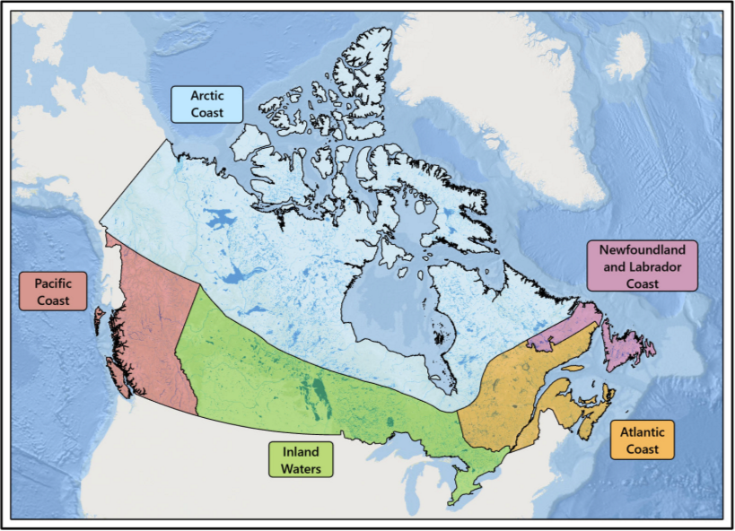
Pacific Coast
2026 Edition
List of Lights, Buoys and Fog Signals – Pacific Coast
2026 Edition
Aussi disponible en français :
Livre des feux, des bouées et des signaux de brume – Côte du Pacifique
Édition 2026
Published under the Authority of:
Canadian Coast Guard Programs
Aids to Navigation and Waterways
Montreal, QC H2Y 2E7
For more information, contact DFO.Notmar-Notmar.MPO@dfo-mpo.gc.ca.
© His Majesty the King in Right of Canada,
as represented by the Canadian Coast Guard, 2026.
Cat. No. D16-7E-PDF. (Electronic PDF, English)
ISSN 2817-3678
Cat. No. D16-7F-PDF. (Electronic PDF, French)
ISSN 2817-3686
A web version is available here:
List of Lights, Buoys and Fog Signals (English)
Livre des feux, des bouées et des signaux de brume (French)
Geographic Coverage of the List of Lights Volumes
Record of Changes for 2026
List of Lights Section | Corrections Published* | |
|---|---|---|
1 - 20 | Kootenay Lake | Edn 02 |
23 | Slocan Lake | |
26 - 41 | Upper and Lower Arrow Lake - Columbia River | |
42.8 - 51 | Shuswap Lake | |
51.5 - 64.4 | Okanagan Lake | |
65 - 65.2 | Seton Lake | |
66 - 179.1 | West Coast, Vancouver Island | |
180 - 216.4 | Juan de Fuca Strait | |
222.8 - 264 | Haro Strait | Edn 02 |
265.2 - 309.5 | Southern Strait of Georgia | |
310 - 371 | Fraser River - South Arm | Edn 02 |
372 - 373.7 | Pitt Lake | |
374 - 380 | Harrison Lake | |
380.5 - 385 | Fraser River - Middle Arm and North Arm | |
385.3 - 416.5 | Vancouver Harbour | |
417 - 432 | Howe Sound | |
433 - 447.2 | Vancouver Island | |
447.5 - 510 | Northern Strait of Georgia | Edn 02, Edn 03, Edn 05 |
511 - 517.5 | Discovery Passage | Edn 05 |
518 - 544.6 | Johnstone Strait | |
545 - 553.5 | Broughton Strait | |
554 - 569 | Queen Charlotte Strait | |
569.2 - 586 | Queen Charlotte Sound | |
587 - 718.5 | Northern Inside Channels | Edn 05 |
719 - 768.2 | Pacific Coast | |
768.6 - 812 | Haida Gwaii | Edn 02, Edn 05 |
813 | Babine Lake | |
815 | François Lake | |
817.5 - 821.5 | Stuart Lake | |
821.7 - 827.5 | Quesnel Lake | |
830 - 845 | Trembleur Lake |
*Note: The detailed corrections to this volume of the List of Lights, Buoys and Fog Signals can be found in the following 2026 publications of the Monthly Editions of Notices to Mariners (Eastern edition only).
Suggestions and Corrections Form
This form is specifically for suggestions and corrections to Notices to Mariners publications, including the List of Lights, Buoys and Fog Signals publications. It is available online and also in fillable PDF format.
For more information on the aids to navigation in this publication:
Please refer to the list of Canadian Coast Guard Aids to Navigation offices found at the end of this section of the publication.
To report emergencies or navigational hazards:
Contact your nearest MCTS centre
•VHF channel 16 (156.8 MHz)
•MF/HF frequency 2182 kHz/4125 kHz (where
available)
•∗16 on a cellphone (where available)
Emergency changes and, subsequently, the return to normal operation of the aid, are broadcast by Navigational Warnings as soon as possible.
Table of Contents
International Abbreviations Used
Column Descriptions for an Aid to Navigation (Lights, Lighted Buoys, Fog Signals)
Column Descriptions for the RACON Annex
Column Descriptions for the AIS AtoN Annex
Conversion Table for Heights and Distances (Metres to Feet)
General Information
The Canadian Aids to Navigation System
The Canadian Aids to Navigation System is comprised of a mix of visual, audible and electronic aids to navigation, which are provided to assist mariners in determining position and course, to warn of dangers or obstructions or to advise of the location of the best or preferred route.
It is a combined Lateral-Cardinal system and conforms to the IALA (International Association of Marine Aids to Navigation and Lighthouse Authorities) Maritime Buoyage System, Region B. Details of the Canadian aids to navigation system can be found in The Canadian Aids to Navigation System 2023 publication. This publication also contains information on the legal provisions relevant to, or governing aids to navigation.
Private Aids
Aids which are identified by the words “Private aid” are not owned by the federal government, a provincial government or a government agency. The Canadian Coast Guard considers any aid owned by a municipal government to be private. Since their quality of operations may not be maintained to Canadian Coast Guard standards, the user should ensure that the service provided by these aids is adequate for their needs in regard to navigating the ship safely.
Cautions in the Use of Aids to Navigation
1.Mariners are cautioned not to rely solely on buoys for navigation purposes. Navigation should be by bearings or angles from fixed aids on shore or other charted landmarks and by sounding or through the use of satellite or radio-navigation systems, whenever possible.
2.Most aids to navigation are not under continuous observation and mariners should be aware that failures and displacements do occur. The Canadian Coast Guard does not guarantee that all aids to navigation will operate as advertised or in the positions advertised, at all times. Mariners observing aids to navigation not operating, out of position, operating at reduced service, showing improper characteristics, damaged, or missing are responsible for reporting such problems to the nearest Canadian Coast Guard Marine Communications and Traffic Services Centre immediately or to the closest Canadian Coast Guard office.
3.Aids to navigation are subject to damage, failure and moving off position, which may be caused by ice, storms, vessel strikes, and power failures. Ice and storm damage may be widespread and require considerable time to repair. Damage to an isolated aid may exist for a long time without being discovered and reported. Floating aids and pier lights in or near the water which are exposed to particularly rigorous strain during ice movement are at the greatest risk of damage.
4.Mariners are cautioned that aids to navigation may fail to exhibit their advertised characteristics. Lights may be extinguished or appear at a reduced intensity and audible signals may not function due to ice, collisions, mechanical failure, and, in the case of bell and whistle buoys, calm water. The shape of an aid to navigation may be altered by ice formation or damage. The colour of an aid to navigation may be altered by freezing spray, marine growth, or fouling by birds. AIS aids, transponders, or shore-based systems may fail, and errors may be introduced by some electronic navigation systems.
5.Buoy positions shown on nautical charts should be considered as approximate positions. There are a number of limiting factors in accurately positioning buoys and their anchors. These factors include prevailing atmospheric and sea conditions, tidal and current conditions, seabed conditions and the fact that buoys are moored to anchors by varying lengths of chain and may drift about their charted positions within the scope of their moorings.
6.Since moving ice is liable to move buoys from their advertised positions, mariners should proceed with extreme caution under these circumstances.
7.Mariners are reminded that because of differences in horizontal datum (i.e. NAD 27, NAD 83, WGS84), grids on charts of an area may vary from one chart to another. When plotting the positions of aids to navigation by the latitude and longitude method, the results should be checked against other available information.
8.In some instances, it is necessary to establish a buoy in close proximity to or on a navigational hazard (e.g. shoal, reef or ledge). In these instances, the buoy symbol may be slightly offset on the chart in the direction of the preferred navigable water so that the existing hazard depicted on the chart will not be overprinted by the buoy symbol. Such offsets will be indicated on the chart by means of an arrow.
9.Mariners are cautioned not to navigate too closely to a buoy and risk a collision with it, its mooring, or with the underwater obstruction which it marks.
10.Many lights are equipped with sun switches. These lights, both on shore and on most buoys, may be unlit between sunrise and sunset. Mariners unable to see these lights during the daylight hours should not assume that the equipment is malfunctioning.
11.Atmospheric conditions can have a considerable effect on light transmission and the visibility of lights. For example:
a)The distance to a light cannot be reliably estimated
from its apparent brightness.
b)It is difficult to distinguish between a white light
and a yellow or blue light seen alone at night, except at a
short distance.
c)Under some atmospheric conditions, white and yellow
lights take on a reddish hue.
d)Alternating lights with phases of different luminous
intensity may change their apparent characteristics at
different distances because some phases may not be
visible.
e)When observed from similar distances, lower
intensity lights are more easily obscured by conditions of
low visibility than more powerful lights. Coloured lights may
appear to be a lower intensity than white lights and are more
quickly lost under unfavourable circumstances.
f)Ice, frost, moisture, or dirt may form on lantern
windows during cold weather or over time and more
particularly this may reduce their visibility and could cause
coloured lights to appear white.
g)A light exhibiting a very short flash may not be
visible at as great a range as a light exhibiting a longer
flash.
12.The mariner should not rely solely on colour when using a sector light, but should verify the vessel's line of position by taking a bearing on the light. On either side of the line of demarcation, between white and red, and also between white and green, there is always a small arc of uncertain colour.
13.When the arc of visibility of a light is cut off, for example by sloping land, the bearing at which it appears or disappears will vary with the observer's distance and height of eye.
14.The sighting of a light may be adversely affected by different situations, such as a strongly illuminated background, a colourful, or a changing background.
15.Audible aids to navigation. In view of the varying distances at which a fog signal can be heard at sea, and the frequent occurrence of fog near, but not observable from, a fog signal, mariners are cautioned that:
a)When approaching land in fog, they should not rely implicitly upon these fog signals, but should always take soundings, which in nearly all cases will give sufficient warning of danger.
b)Distance from a fog signal should not be judged by the power of the sound. Under certain atmospheric conditions, the sound may be lost at a very short distance from the signal. These conditions may vary within a very short period of time. Mariners should not assume that a fog signal is not in operation because they do not hear it, even when in close proximity.
16.Visual aids to navigation provided by the Canadian Coast Guard are for the purpose of assisting marine navigation. Hunters, snowmobilers and ice fishers are cautioned that aids to navigation installed for marine navigation purposes cannot be relied upon after the close of the marine navigation season. Such aids may stop operating without warning and will not be re-commissioned by the Canadian Coast Guard until the next opening of marine navigation season.
17.Mariners should be aware of the type of AIS aid to navigation they are using. Physical AIS aids are broadcast from a traditional aid, so their actual positions are reported, and they may be flagged as off position. Virtual AIS aids are broadcast from remote stations, and there are no associated traditional aids at their broadcast position. A Synthetic (Predicted) AIS aid is broadcast from a remote station as a signal placed over the position of a traditional fixed aid and its position will remain static if the associated aid is moved, damaged, or destroyed. AIS aid to navigation types may be differentiated by their information displays.
Regional Information
Western Region
The lights and buoys along the Pacific coast are maintained in operation throughout the year. Details on changes made to fixed and floating aids are published in a Navigational Warning by the Region and disseminated by means of radio broadcast when they occur.
In the spring, freshet conditions on the Fraser River cause the positions of floating aids to be unreliable. Displaced buoys on the Fraser River may be temporarily removed from service, in which case mariners will be advised by a Navigational Warning.
The commissioning of seasonal aids may be delayed if weather and/or ice conditions preclude buoy tender operations. Mariners are urged to take every precaution and not to rely solely on aids to navigation.
NOTE: Most floating seasonal aids are removed at the end of the navigational season, but a small percentage are left in the water during the winter. Mariners, who use channels marked by such buoys before the official opening of the navigational season, are cautioned that these buoys may not be in their advertised positions due to storms and shifting ice caused by winter conditions. After the position and the condition of the aids have been verified, a Navigational Warning will be issued to advise mariners that the aids have been checked and that the channels in each local area are open for navigation. Such Notices may be promulgated over the Coast Guard VHF radio network or may appear in the monthly edition of Notices to Mariners.
International Abbreviations Used
|
International Abbreviation |
Term in English |
|
AIS |
Automatic Identification System |
|
Al |
Alternating |
|
Bu |
Blue |
|
F |
Fixed |
|
Fl |
Flashing |
|
G |
Green |
|
h |
Hour |
|
Iso |
Isophase |
|
LFl |
Long-flashing |
|
m |
Metre(s) |
|
Mo |
Morse Code |
|
Oc |
Occulting |
|
ODAS |
Ocean Data Acquisition System |
|
Q |
Quick |
|
R |
Red |
|
s |
Second(s) of time |
|
V-AIS |
Virtual AIS (AtoN) |
|
VQ |
Very Quick |
|
W |
White |
|
WGS84 |
World Geodetic System 1984 |
|
Y |
Yellow |
National Abbreviations
|
National Abbreviation |
Term in English |
|
E. |
East |
|
Intl |
International |
|
N. |
North |
|
NAD 27 |
North American Datum of 1927 |
|
NAD 83 |
North American Datum of 1983 |
|
NE. |
North-east |
|
NM |
Nautical mile(s) |
|
No. |
Number |
|
NW. |
North-west |
|
RACON |
Radar beacon |
|
S. |
South |
|
SE. |
South-east |
|
sil. |
Silence |
|
SW. |
South-west |
|
VHF |
Very high frequency |
|
W. |
West |
Light Signals
General Terms Related to Light Signals
•Bearings: limits of
light sectors and areas of visibility of lights and the
alignments of leading lights and directional lights, given as
bearings from seaward. The bearings of sectors are given in
clockwise order.
•Character: distinctive
combination of various aspects of a light which appear
regularly or rhythmically allowing it to be identified, for
example: fixed, flashing, alternating, etc.
•Colour: colour exhibited
by the light.
•Period: time occupied by
an entire cycle of intervals of light (flash) and darkness
(eclipse).
•Phase: each successive
element of a rhythmic light’s cycle (i.e. flash, eclipse).
•Rhythm: pattern of light
(flash) and darkness (eclipse) displayed by the light of an
aid that allows its function to be identified in conjunction
with the period and the colour of the light.
|
Types of Light Signal |
Definitions |
|
Aeronautical Light |
A light generally of great intensity and elevation principally for aircraft navigation. Because of their intensity, these are often the first lights to be seen when approaching land. |
|
Direction Light |
A light illuminating a very narrow sector, used to mark a direction to be followed. This sector may be flanked by sectors of greatly reduced intensity or by sectors of different colour or character. |
|
Emergency Light or |
A light that will be illuminated should the main light fail and has a distinctive light characteristic and is at a reduced intensity. |
|
Locator Light |
A secondary all-round light, placed on or near the support of a main sectored light of higher intensity, to facilitate its location by mariners before being able to detect the directional light. |
|
Main Light |
The light providing the main function of the aid, or the most important light in a group of two or more lights on the same support or on neighbouring supports. |
|
Range Lights |
Two or more lights associated to form one or more
leading lines (or ranges). A leading line defined by
two such leading lights is called the axis of the
lights. |
|
Secondary Light |
A light placed on or near the support of a main light and having a special use in navigation. |
|
Sector Light |
A light presenting differing appearances (particularly
in colour) over various parts of the horizon of
interest to marine navigation. |
Audible Signals
The specific audible signal of an aid to navigation is indicated in the “Remarks” column.
|
Types of Audible Signals |
Definitions |
|
Bell |
Equipment producing a characteristic sound by striking a bell-shape. |
|
Fog Horn |
Equipment consisting of a tube of varying transverse dimensions producing a characteristic sound. |
|
Whistle |
Equipment producing a shrill sound by releasing compressed air or steam across an opening. |
Electronic Aids to Navigation
Details regarding radar reflectors, radar beacons (RACONs) and Automatic Identification System aids to navigation (AIS AtoN) can be found in The Canadian Aids to Navigation System 2023 publication.
Radar reflectors
All lighted buoys reflect radar and thus radar reflectors on
buoys are not mentioned in the “Remarks” column.
Some shore lights have a radar reflector to enhance their radar
conspicuousness and these are noted in the “Remarks” column.
Radar Beacons (RACONs)
Radar beacons (RACONs) may be established at lighthouses, on buoys or at other specific charted locations ashore or afloat to enhance identification and detection range of these features by radar. A RACON can be identified by a series of coded pulses (Morse code). Some RACONs operate only in the “X” band (9320 to 9500 MHz), whilst others are dual band of “X & S” (“X” band plus “S” band of 2920 to 3100 MHz).
Notes:
•A RACON’s actual range is dependent on many factors, including, but not limited to, the height of the RACON above the water, its type and model, the height of the radar antenna triggering the RACON, the radar type, model and settings, as well as the band used (X or S), the prevailing weather conditions, and whether there is a clear line of sight or not.
•As a guideline, and in ideal conditions, the nominal range for a RACON installed on a buoy should be between 6 and 8 nautical miles, while the range of a RACON installed on a shore structure should be somewhere between 10 and 20 nautical miles.
RACONs shown in this volume are indicated at the nearest light. The Morse code and the band of a RACON are noted in the “Name / RACON” column.
•A detailed listing of RACONs can be found in the dedicated annex at the end of each volume of the List of Lights, Buoys and Fog Signals publication.
oThis annex contains a list of all lighted aids with a RACON in order of their national number (No.), which are then listed under their respective section. Standalone RACONs are listed in the section that reflects most closely to their geographic location.
Automatic Identification System Aids to Navigation (AIS AtoN)
Automatic Identification System aids to navigation (AIS AtoN) may
be established to supplement existing aids to navigation or aid
systems, or where physical aid placement is impractical.
The following types of AIS AtoN may be used in Canada:
•Physical AIS AtoN: signal transmitted from an aid to navigation that physically exists.
•Virtual AIS AtoN: signal transmitted from a remote base station, indicating an aid that is only displayed on electronic navigation equipment and does not physically exist.
•Synthetic (Predicted) AIS AtoN: signal transmitted from a remote base station, supplementing a physical fixed aid whose position is not monitored.
AIS AtoN shown in this volume are those deployed in a permanent manner, and are listed with their AIS AtoN type and Maritime Mobile Service Identity (MMSI) number. They can also be found listed in the dedicated annex for reference. Additional information may be obtained from the Canadian Coast Guard e-Navigation Portal.
Information on position, characteristic, colour, visible range, bearings, and arcs of visibility is intended for practical use in navigation. It should not be used as a basis for surveys or other work requiring a high order of precision.
Column Descriptions for an Aid to Navigation (Lights, Lighted Buoys, Fog Signals)
Lights, lighted buoys and fog signals are listed and described
in an eight-column table. The contents and principal
conventions are used as follows:

Column 1 – National and International Numbers
The national number (No.) is a number assigned to an aid to navigation to service a specific position. It is unique to its proper volume and can be one to eight digits long, including four decimal places. Generally, the numbering increases in the upstream direction.
The international number (Intl No.) is listed under the
national number. It starts with one capital letter and
followed by four to seven digits, including three decimal
places. These numbers correspond to the numbers given in the
Admiralty List of Lights and Fog Signals publication
by the United Kingdom Hydrographic Office (UKHO).
There are two volumes that cover Canadian aids to navigation:
•Volume G: Western Side of South Atlantic Ocean and East Pacific Ocean
oThis covers the Pacific Coast volume of the List of Lights, Buoys and Fog Signals.
•Volume H: Northern and Eastern Coasts of Canada
oThis covers the Newfoundland and Labrador Coast, Atlantic Coast, Inland Waters and Arctic Coast volumes of the List of Lights, Buoys and Fog Signals.
Column 2 – Name and RACON
The name of an aid to navigation is based off official geographical names as per the Canadian Geographical Names Database by Natural Resources Canada. When there is no official name that is applicable to the aid, then local names would be used instead.
Other elements can be found in the name such as the type of light signal, the function of the aid (as described in The Canadian Aids to Navigation System 2023 publication), and physical identifier (such as an aid designator on a buoy).
The typographic elements employed allow the following distinctions to be made:
•Upright and bold type: land-based
lights with nominal range of at least 15 nautical miles
•Upright type: other land-based lights
•Italic type: buoys
If an aid to navigation is equipped with a RACON, then that will be indicated in a separate section underneath the aid name and includes the Morse Code letter and equivalent coded signal, and the radar band(s) that the RACON operates in.
Column 3 – Location and Geographic Positions
Additional information on the location of the aid to navigation may be described to complement what is written in the aid name.
The geographic positions of all aids to navigation listed in this volume are shown in degrees, minutes and seconds and are given in the North American Datum of 1983 (NAD 83) with an accuracy to a tenth of second.
In the case of range lights, the position of the rear light is also given by bearing and distance from the front light. The bearing is from seaward.
Column 4 –Light Characteristics
Light characteristics are composed of its rhythm (which includes the character), colour, and period.
•The period is not applicable to lights with a fixed (F) character.
Only the light characteristics of the main light of an aid to navigation are indicated in this column. Any additional light (secondary light, emergency light/mode, locator light or aeronautical light) is indicated in the “Remarks” column with their light characteristics.
Details regarding the basic types of light characters can be found in The Canadian Aids to Navigation System 2023 publication.
Common Light Flash Characters
Below is a list of common light flash characters with their typical flash and eclipse sequence. Definitions of these characters have been included for reference. (Please note that any uncommon light flash characters and variations on the sequence of a character listed below is indicated in the “Remarks” column.)
Fixed
(F) Light: light which
appears continuous and steady and of constant colour.
Rhythmic
Light: light exhibiting its character in recurring
regular cycles.
•Isophase (Iso): light in which the alternations of light (flash) and darkness (eclipse) are of equal length.
o“Iso 2s”: flash 1.0 s; eclipse 1.0 s
•Flashing (Fl): light in which the flash is clearly shorter than the duration of darkness and in which the flashes of light are all of equal duration.
oSingle-flashing light: flashing light in which a flash is regularly repeated at a rate of less than 50 flashes per minute.
“Fl 4s”: flash 0.5 s; eclipse 3.5 s
oLong-flashing light: flashing light in which an appearance of light of not less than 2 seconds in duration (long flash) is regularly repeated.
“LFl 10s”: flash 2.0 s; eclipse 8.0 s
oGroup-flashing light: flashing light in which a group of flashes, specified in number, is regularly repeated.
“Fl(2) 5s”: flash 0.4 s;
eclipse 0.6 s; flash 0.4 s; eclipse
3.6 s
“Fl(2) 10s”: flash 1.0 s;
eclipse 1.0 s; flash 1.0 s; eclipse
7.0 s
“Fl(5) 20s”: 4(flash 0.5 s;
eclipse 1.5 s); flash 0.5 s; eclipse 11.5 s
oComposite group-flashing light: light similar to a group flashing light except that successive groups in a period have different numbers of flashes.
“Fl(2+1) 6s”: flash 0.3 s; eclipse 0.4 s; flash 0.3 s; eclipse 1.2 s; flash 0.3 s; eclipse 3.5 s
“Fl(2+1) 10s”: flash 0.5 s; eclipse 0.7 s; flash 0.5 s; eclipse 2.1 s; flash 0.5 s; eclipse 5.7 s
•Occulting (OC): light in which the flash is clearly longer than the duration of darkness (eclipse) and in which the intervals of darkness are all of equal duration.
oSingle-occulting light occulting light in which an eclipse is regularly repeated.
oGroup-occulting light occulting light in which a group of eclipses are regularly repeated. The total duration of light in each period may be equal to the total duration of darkness.
•Quick (Q): light in which flashes are repeated at a rate of not less than 50 flashes per minutes but less than 80 flashes per minute.
oContinuous quick-flashing light: quick light in which a flash is regularly repeated.
“Q 1s”: flash 0.3 s; eclipse 0.7 s
oGroup quick-flashing light: quick light in which a specified group of flashes, specified in number, is regularly repeated.
“Q(3) 10s”: 2(flash 0.3 s;
eclipse 0.7 s); flash 0.3 s; eclipse
7.7 s
“Q(9) 15s”: 8(flash 0.3 s;
eclipse 0.7 s); flash 0.3 s; eclipse 6.7 s
oGroup quick-flashing and long-flash light: light in which a group of quick flashes is followed by a single long flash.
“Q(6) + LFl 15s”: 6(flash 0.3 s; eclipse 0.7 s); flash 2.0 s; eclipse 7.0 s
•Very Quick (VQ): very quick-flashing light in which a flash is regularly repeated at a rate of not less than 80 flashes per minute but less than 159 flashes per minute (usually either 100 or 120 flashes per minute).
oContinuous very quick-flashing light: very quick light in which a flash is regularly repeated.
“VQ 0.5s”: flash 0.2 s; eclipse 0.3 s
oGroup very quick-flashing light: very quick light in which a specified group of flashes, specified in number, is regularly repeated.
“VQ(3) 5s”: 2(flash 0.2 s;
eclipse 0.3 s); flash 0.2 s; eclipse
3.8 s
“VQ(9) 10s”: 8(flash 0.2 s;
eclipse 0.3 s); flash 0.2 s; eclipse 5.8 s
oGroup very quick-flashing and long-flash light: light in which a group of very quick flashes is followed by a single long flash.
“VQ(6) + LFl 10s”: 6(flash 0.2 s; eclipse 0.3 s); flash 2.0 s; eclipse 5.0 s
•Morse Code (Mo): light in which flashes of light of two clearly different durations are grouped to represent a character or characters in the Morse Code.
o“Mo(A) 6s”: flash 0.3 s; eclipse 0.6 s; flash 1.0 s; eclipse 4.1 s
Alternating (Al) Light: rhythmic light exhibiting different colours during each cycle.
Column 5 – Focal Height Above Water
Focal height of a light is above Higher High Water Large Tides, except in the St. Lawrence River west of Trois-Rivières, in the St. Lawrence Seaway, in the Great Lakes and in other inland waters where it is above chart datum.
The focal height is given in metres (m).
Column 6 – Nominal Range
The nominal range of a light used as a marine aid to navigation is its luminous range in a homogeneous atmosphere in which the meteorological visibility is 10 nautical miles.
The nominal range is given in nautical miles (NM). It is in upright and bold type when it is greater than or equal to 15 NM, and in upright type when it is less than 15 NM.
Column 7 – Description and Height of Structure Above Ground Level
For buoys, the shape and colour(s) of the buoy is described, along with its designator (if applicable).
For fixed aids, the shape and colours of the structure and daymark are described (if applicable).
•For range lights: if a daymark is mentioned, but no shape is described, then it can be assumed that the shape of the daymark is trapezoidal.
•The height of the structure above ground level will
be indicated in a separate section underneath the aid
description (if applicable).
Column 8 – Remarks, Audible Signals and AIS
This column is dedicated to any notable remarks regarding an aid to navigation, including separate sections for audible signals and AIS aids to navigation (if applicable).
•Private aid (as applicable)
•Period of service of the aid to navigation (applies to all aids)
oSeasonal: AtoN that is
in service for a certain service period, usually determined
by winter weather.
oSeasonal
(in place year round): AtoN that has a specific
service period, but is not removed from its established
position between periods.
oYear
round: AtoN that is operational all-year round. This
includes summer buoys with winter spar replacements.
■ Year-round lighted spar (YRLS) buoys mentioned here, if applicable.
•Winter spar (buoys only, if applicable)
o This mention indicates if a summer buoy is replaced by a winter spar during the winter season.
•Light operation (as applicable)
oThe light on an aid to navigation operates at night only, unless otherwise indicated here (such as day or 24 hours).
•Light flash character sequence (as applicable)
oThe flash and eclipse sequence of any uncommon light flash character or variation on common light flash characters described above will be indicated here.
•Arc of visibility (lighted fixed aids only, if applicable)
oThe light of an aid to navigation is visible from all points of marine approach, unless indicated here (e.g. sector lights). The bearings are given from seaward.
•Additional lights (lighted fixed aids only, if applicable)
oIf there are any additional lights to the main light (such as a secondary light, emergency light/mode, locator light or aeronautical light), then they will be indicated here with their light characteristic.
Note: The light characteristic of “Emergency Mode” will not be indicated as it is always Iso 1s.
•Radar reflector (shore lights only,
if applicable)
•Additional remarks (as applicable)
oAll other remarks will be listed here such as VHF activation procedures.
The “Audible Signals” section will indicate:
•the type of audible signal (bell, fog horn or whistle) and
•any other pertinent information (such as the sequence of blast and silence for fog horns).
The “AIS” section will indicate:
•the type of AIS AtoN (physical, virtual or synthetic
AIS AtoN),
•the MMSI number, and
•the AtoN Type, as defined by The International
Telecommunication Union (ITU), for virtual AIS AtoN.
Column Descriptions for the RACON Annex

Column 1 – National Number
The national number (No.) is a number assigned to an aid to navigation to service a specific position. It is unique to its proper volume and can be one to eight digits long, including four decimal places.
If the RACON is part of a lighted aid, then this will be the same number as found in the table of lights.
Column 2 – Name
The name of an aid to navigation is based off official geographical names as per the Canadian Geographical Names Database by Natural Resources Canada. When there is no official name that is applicable to the aid, then local names would be used instead.
If the RACON is part of a lighted aid, then this will be the same name as found in the table of lights.
Column 3 – Geographic Positions
The geographic positions of all aids to navigation listed in this volume are shown in degrees, minutes and seconds and are given in the North American Datum of 1983 (NAD 83) with an accuracy to a tenth of second.
Column 4 – Morse Code Identifier
This column indicates the Morse Code letter and equivalent coded signal.
Column 5 – Radar Bands
This column indicates the radar band(s) that the RACON operates in.
Column 6 – Period of Service
This columns indicates the period of service of the aid.
Column Descriptions for the AIS AtoN Annex

Column 1 – LL No.
The national number (LL No.) is a number assigned to an aid to navigation to service a specific position. It is unique to its proper volume and can be one to eight digits long, including four decimal places.
AIS AtoN, including virtual AIS AtoN, are also found in the table of lights.
Column 2 – AIS Broadcast Name
Due to the limitations on the number of characters allowed for this information in Message 21, the AIS Broadcast Name is a truncated or abbreviated version of the name found in the table of lights.
Column 3 – Geographic Positions
The geographic positions of all aids to navigation listed in this volume are shown in degrees, minutes and seconds and are given in the North American Datum of 1983 (NAD 83) with an accuracy to a tenth of second.
Column 4 – Type of AIS AtoN
The column indicates the specific type of AIS AtoN: physical, virtual or synthetic (AIS AtoN).
Column 5 – AtoN Type (ITU)
This column refers to the AtoN Type as defined by The International Telecommunication Union (ITU).
Column 6 – Remarks
This column indicates the MMSI number and the period of service of the aid.
Conversion Table for Heights and Distances (Metres to Feet)
|
Feet |
|
|
1 |
3.2 |
|
2 |
6.5 |
|
3 |
9.8 |
|
4 |
13.1 |
|
5 |
16.4 |
|
6 |
19.6 |
|
7 |
22.9 |
|
8 |
26.2 |
|
9 |
29.5 |
|
10 |
32.8 |
|
20 |
65.6 |
|
30 |
98.4 |
|
40 |
131.2 |
|
50 |
164.0 |
|
100 |
328.0 |
|
200 |
656.1 |
|
300 |
984.2 |
|
400 |
1,312.3 |
|
500 |
1,640.4 |
|
1,000 |
3,280.8 |
|
2,000 |
6,591.6 |
Note:
The following conversion factors may also be of assistance:
•multiply feet by 0.3048 to obtain metres
•divide metres by 0.3048 to obtain feet
Table of Distances
Table of Distances at which objects can be seen at sea, according to their respective elevations and the elevation of the eye of the observer.
|
Distances (nautical miles) |
|
|
2 |
2.9 |
|
3 |
3.6 |
|
4 |
4.2 |
|
5 |
4.6 |
|
6 |
5.1 |
|
7 |
5.5 |
|
8 |
5.9 |
|
9 |
6.2 |
|
10 |
6.6 |
|
12 |
7.2 |
|
14 |
7.8 |
|
16 |
8.3 |
|
18 |
8.8 |
|
20 |
9.3 |
|
25 |
10.4 |
|
30 |
11.4 |
|
35 |
12.3 |
|
40 |
13.1 |
|
45 |
13.9 |
|
50 |
14.7 |
|
55 |
15.4 |
|
60 |
16.1 |
|
70 |
17.4 |
|
80 |
18.6 |
|
90 |
19.7 |
|
100 |
20.8 |
|
120 |
22.8 |
|
140 |
24.6 |
|
160 |
26.3 |
|
180 |
27.6 |
|
200 |
29.4 |
|
250 |
32.9 |
|
300 |
36.0 |
|
350 |
38.9 |
|
400 |
41.6 |
Example: An observer whose eye is 12 metres above the water can see a light having an elevation of 40 metres above the water at a distance of: 7.2 + 13.1 = 20.3 nautical miles.
Nomogram (Geographical Range)

By using the above Nomogram, a geographical range can be determined by placing a straight edge against the height of the respective light and the height of the observer above water level.
Nominal Range Diagram
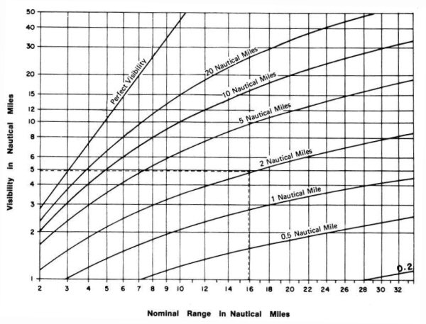
Column 7 of the List of Lights gives the nominal range of each light, where there is sufficient light to be seen 2 nautical miles or more when the meteorological visibility is 10 nautical miles.
When the mariner obtains the meteorological visibility from the weather report, he can find the distance the light can be seen at night from the nominal range diagram.
Example: The List of Lights gives the nominal range of 16 nautical miles. The weather report gives the meteorological visibility of 2 nautical miles. The point on the bottom of the diagram marked “16” is followed upwards until it intersects the curve marked “2 Nautical Miles.” Follow that height horizontally to the left margin to find that the visibility of the light, which is 5 nautical miles.
Caution: The nominal range diagram is correct when the meteorological visibility is the same in the whole of the distance between the ship and the light. Conditions occur when this may not be true.
Mariners or other persons wishing to communicate with the Canadian Coast Guard concerning aids to navigation may do so at the following offices:
|
Regional Headquarters
P.O. Box 5667 MCTSRefer to RAMN (H/N) Navigational Warnings
Telephone:1-709-695-2168 (B)
(H/N)
Email:NAVWARN.MCTSPortAuxBasques@innav.gc.ca ARCTIC REGION
Yellowknife, NTSuperintendent Telephone:1-867-444-0109 (E) Email:DFO.CCGArcticAidsNavigation-AidesalaNavigationArctiqueGCC.MPO@dfo-mpo.gc.ca Navigational Warnings Telephone: 1-867-979-5269 (B) (H/N) |
CENTRAL REGION St. Lawrence Sector
Québec, QCSuperintendent, Aids to
Navigation
Telephone:1-418-649-6999
(B) Email:DFO.AtoNStLawrence-StLaurentAalaN.MPO@dfo-mpo.gc.ca Great Lakes Sector
Sarnia, ONSupervisor, Operations
Telephone:1-226-402-1052
(E) MCTS Refer to RAMN (H/N)
Navigational Warnings
WESTERN REGION
Victoria, BCSuperintendent
Telephone:1-250-450-2600
(E)
Navigational Warnings |
|
(B) Bilingual Service (E) English Only Service (TF) Toll Free (H/N) Holidays and Nights |
|
Report a problem on this page
- Date modified: