
5AGeneral Requirements for Oceans Act Marine Protected Areas and Fisheries Act Marine Refuges
Under the Oceans Act, regulations designating a Marine Protected Area may be made, by either the Governor in Council (per ss. 35(3)) or a Minister of Fisheries and Oceans Ministerial Order (per s. 35.1), for one or more of the following reasonsFootnote1:
(a)commercial
and non-commercial fishery resources and their habitats;
(b)the
conservation and protection of endangered or threatened species
and their habitats;
(c)the
conservation and protection of unique habitats;
(d)the
conservation and protection of marine areas of high
biodiversity or biological productivity;
(e)the
conservation and protection of any other marine resource or
habitat as is necessary to fulfill the mandate of the Minister
of Fisheries and Oceans; and
(f)the
conservation and protection of marine areas for the purpose of
maintaining ecological integrity.
In addition under ss.52.1 the Governor in Council may, on the recommendation of the Minister, make regulations for carrying out the purposes and provisions of the Oceans Act and, in particular, but without restricting the generality of the foregoing, may make regulations:
(a)prescribing marine environmental quality requirements
and standards;
(b)respecting the powers and duties of persons
designated by the Minister as enforcement officers; and
(c)respecting the implementation of provisions of agreements made under this Act.
General Prohibitions (Prohibited Activities)Footnote2
Oceans Act Marine Protected Area regulations contain a prohibition that generally prohibits the disturbance, damage, destruction or removal of any living marine organism or any part of its habitat within the Marine Protected Areas. Recent amendments to the Oceans ActFootnote3 now also provide for the protection of unique geological or archeological features that lie within an area designated by Ministerial Order.
Exceptions (Permitted Activities)
Governor in Council Marine Protected Area regulations include various exceptions, allowing for the continuation of activities that do not jeopardize the area’s conservation objectives. A Ministerial Order Marine Protected Area is a measure that effectively “freezes the footprint” of the area, allowing most “ongoing” activities to continue while prohibiting those that are not “ongoing”.
Marine Protected Area designated by either Governor in Council regulations or Ministerial Orders recognize and accommodate the exercise of international navigational rights Marine Protected Area regulations generally provide for vessel operation in compliance with relevant navigational requirements (ex. provisions of the Canada Shipping Act, 2001 and relevant requirements of the International Maritime Organization).
Activities carried out for the purpose of public safety, law enforcement or national security or for the exercise of Canadian sovereignty are covered by separate exceptions and are therefore not subject to the general prohibitions evidenced in Marine Protected Areas made by the Governor in Council and Ministerial.
Report of Incident
Specific reporting requirements for certain Marine Protected Areas can be found in the respective regulation.
Penalties
Individuals, corporations and ships that contravene Oceans Act Marine Protected Areas regulations are guilty of an offence and liable to a fine as specified in section 39.6 of the Act. Individuals, corporations and ships that contravene these regulations may also be subject to requirements specified under other applicable Federal legislation.
1.Marine Protected Areas in Eastern Canada
The following section provides information on Marine Protected Areas that have been designated under the Oceans Act in Eastern Canada.
1.1The Gully Marine Protected Area
The Gully Marine Protected Area was designated pursuant to the Oceans Act on May 7th, 2004. The full text of the regulations may be accessed in the Gully Marine Protected Area Regulations.
Coordinates
The Gully is a deep canyon ecosystem on the edge of the Scotian Shelf near Sable Island. The Gully Marine Protected Area is bounded by rhumb lines connecting the following geographical coordinates [North America Datum 1983 (NAD 83)/World Geodetic System (WGS 84)].
|
Point |
Latitude (North) |
Longitude (West) |
|
1 |
44° 13' |
59° 06' |
|
2 |
43° 47' |
58° 35' |
|
3 |
43° 35' |
58° 35' |
|
4 |
43° 35' |
59° 08' |
|
5 |
43° 55' |
59° 08' |
|
6 |
44° 06' |
59° 20' |
The Gully Marine Protected Area is shown in the map below:

Regulatory Requirements for Vessels Operating in the Gully Marine Protected Area
•See
Section 5A - General
Regulatory Requirements for all Oceans Act Marine Protected
Areas.
•Specific
requirements for the Gully Marine Protected Area
oBe aware that for the Gully Marine Protected Area, the
prohibitions extend to the
vicinity of the Marine Protected Area. It is
prohibited to carry out any activity in the vicinity of the
Gully Marine Protected Area that is likely to result in the
disturbance, damage, destruction or removal of any living
marine organism or any part of its habitat within the Marine
Protected Area.
oVessels must avoid discharge of ballast water in the
Marine Protected Area. Please see the Ballast Water
Regulations for additional guidance (including exceptions)
on ballast water management in and around the Marine Protected
Area.
oAny person involved in an incident that is likely to result in any prohibited activity must, within two hours after its occurrence, report the incident to the Canadian Coast Guard.
Guidelines for Vessels Operating in the Area (Year Round)
The following procedures are recommended in order to safeguard the Marine Protected Area and its resources.
Marine Mammal Protection
All marine mammal species are protected in the Marine Protected Area. The main species of concern are northern bottlenose, blue, fin, and Sowerby’s beaked whales. The key threats associated with shipping are acoustic disturbances and vessel collisions. Vessels should adhere to the following measures to ensure marine mammal protection:
1.Vessels
should avoid passage through this area if possible. Avoidance is
the most effective means to eliminate or reduce acoustic
disturbances and vessel collisions.
2.If
passage through this area is required, decrease vessel speed to
10 knots or less and post a look-out to increase the likelihood
of sighting and avoiding marine mammals. Increased caution must
be exercised in conditions of reduced visibility, such as rain,
fog, rough sea state, or at night. Be aware that marine mammals
often travel in small groups dispersed over an area of several
miles.
3.Vessels
should adhere to the following operating measures while
maneuvering around marine mammals:
a.Avoid any sudden changes in speed or direction.
b.Avoid heading directly toward marine mammals.
c.Travel parallel to marine mammals.
d.If it is not possible to maneuver around a marine
mammal or group of marine mammals, slow down immediately,
maintain a minimum distance of 100 metres and wait until
animals are more than 400 metres away before slowly
resuming speed.
e.Note: some marine mammal species
require different minimum distances – please refer to
individual species’ needs in Section 5 of this Notices to
Mariners.
f.If operating a sailing vessel with an auxiliary motor, leave it in idle or use the echo sounder to signal presence.
4.Vessels must comply with all relevant provisions of the Marine Mammal Regulations pursuant to the Fisheries Act. Further guidance is found in Section 5 - General Guidelines for Aquatic Species at Risk and Important Marine Mammal Areas.
5.Marine mammal collisions, entanglements, distressed or dead animals should be reported to the Marine Animal Response Society’s emergency hotline (1-866-567-6277), or via VHF channel 16. Sightings of healthy marine mammals should be reported to XMARwhalesightings@dfo-mpo.gc.ca. The following information about the sighting should be included: date, time, location, and species. Photos and videos should be submitted if available.
6. Report sightings of North Atlantic Right Whales in near real-time (i.e., the same day as sighted or as soon as possible) to DFO.GLFWhales-BaleinesGLF.MPO@dfo-mpo.gc.ca . Detections validated with imagery will be used to inform management measures and will appear on the online platform Whales Insight (canada.ca/whale-insight-map).
a.If you already have a Data Sharing Agreement with the Government of Canada to report sightings directly to Whale Insight in near real-time, please follow those reporting protocols rather than reporting your sightings to the above email, unless it is not possible (such as due to technological issues), in which case sightings must be reported as soon as possible by email to: DFO.GLFWhales-BaleinesGLF.MPO@dfo-mpo.gc.ca.
b.When reporting near real-time sightings of NARW please include: GPS location (latitude and longitude), date and time of sighting, species sighted, number of animals, behavior of animals observed (ex., feeding, travelling, diving), and what photographs/videos were collected.
Pollution Prevention
The Marine Protected Area regulations apply to activities that may cause harm to the marine environment. Vessels must adhere to the following measures to ensure the protection of marine environmental quality:
1.Vessels
must avoid discharges, including ballast water, in the Marine
Protected Area. Vessels should also avoid such
discharges within a minimum distance of 50 kilometers (27
nautical miles) from the Marine Protected Area.
2.Vessels
must report any pollution sightings or incidents to the
Canadian Coast Guard (1-800-565-1633 or VHF
channel 16).
1.2The Musquash Estuary Marine Protected Area
The Musquash Estuary Marine Protected Area was designated pursuant to the Oceans Act on December 14th, 2006. The full text of the regulations may be accessed in the Musquash Estuary Marine Protected Area Regulations.
Coordinates
The Musquash Marine Protected Area consists of the waters that are within an area bounded by the low-water line of the estuary and by the following rhumb lines to their respective points of intersection with the low-water line. All geographical coordinates (latitude and longitude) are expressed in the North America Datum 1983 (NAD 83) geodetic reference system.
|
Point |
Latitude (North) |
Longitude (West) |
|
1 |
45° 11' 19.63” |
66° 15' 37.35” |
|
2 |
45° 11' 23.96” |
66° 15' 33.38” |
|
3 |
45° 08' 47.00” |
66° 15' 11.00” |
|
4 |
45° 09' 08.91” |
66° 13' 55.87” |
|
5 |
45° 08' 28.46” |
66° 15' 12.23” |
|
6 |
45° 08' 14.39” |
66° 15' 35.50” |
|
7 |
45° 08' 35.60” |
66° 14' 16.77” |
The Musquash Estuary Marine Protected Area is shown in the map below:
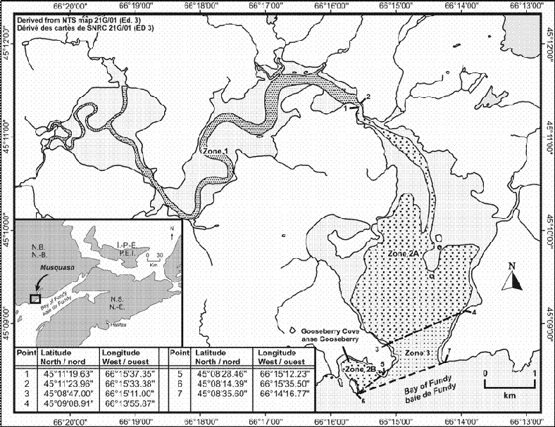
Regulatory Requirements for Vessels Operating in the Musquash Estuary Marine Protected Area
•See Section 5A - General Regulatory Requirements for all Oceans Act Marine Protected Areas.
•Specific requirements for the Musquash Estuary Marine Protected Area
The Musquash Estuary Marine Protected Area is composed of three internal management zones (Zone 1, Zones 2A and 2B, and Zone 3) in which different activities may be permitted, provided that they do not compromise the overall conservation objectives of the Marine Protected Area.
oThe operation of a motorized vessel is not permitted in
Zone 1.
oThe operation of a vessel in Zones 2A and
2B is permitted at a speed no greater than
5 knots.
oThe operation of a vessel in Zone 3 is
permitted at a speed no greater than
8 knots.
oAny person involved in an incident that is likely to result in any prohibited activity shall, within two hours after its occurrence, report the incident to the Canadian Coast Guard.
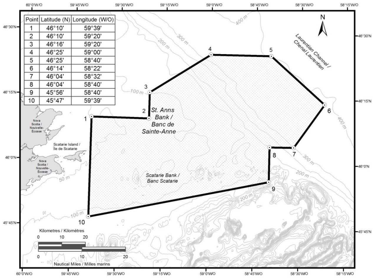
1.3The St. Anns Bank Marine Protected Area
The St. Anns Bank Marine Protected Area was designated pursuant to the Oceans Act on June 2, 2017. The full text of the regulations may be accessed in the St. Anns Bank Marine Protected Area Regulations.
Coordinates
The St. Anns Bank Marine Protected Area is bounded by a series of rhumb lines drawn from points 1 to 10, and then back to point 1. All geographical coordinates (latitude and longitude) are expressed in the North America Datum 1983 (NAD83) reference system.
|
Point |
Latitude (North) |
Longitude (West) |
|
1 |
46° 10' |
59° 39' |
|
2 |
46° 10' |
59° 20' |
|
3 |
46° 16' |
59° 20' |
|
4 |
46° 25' |
59° 00' |
|
5 |
46° 25' |
58° 40' |
|
6 |
46° 14' |
58° 22' |
|
7 |
46° 04' |
58° 32' |
|
8 |
46° 04' |
58° 40' |
|
9 |
45° 56' |
58° 40' |
|
10 |
45° 47' |
59° 39' |
The St. Anns Bank Marine Protected Area is shown in the map below:
Regulatory Requirements for Vessels Operating in the St. Anns Bank Marine Protected Area
•See Section 5A - General Regulatory Requirements for all Oceans Act Marine Protected Areas.
Specific requirements for the St. Anns Bank Marine Protected Area
oVessels must avoid discharge of ballast water in the Marine Protected Area. However, under certain circumstances, vessels when navigating on transoceanic voyages may conduct ballast water exchanges in the portion of the Marine Protected Area that overlaps with the Laurentian Channel, where the water depth is at least 300 m, and only from December 1 to May 1. Please see the Ballast Water Regulations for additional guidance (including exceptions) on ballast water management in and around the Marine Protected Area.
Guidelines for Vessels Operating in the Area (Year Round)
The following procedures are recommended in order to safeguard the Marine Protected Area and its resources:
1.Vessels must comply with all relevant provisions of the Marine Mammal Regulations pursuant to the Fisheries Act. Further guidance is found in Section 5 - General Guidelines for Aquatic Species at Risk and Important Marine Mammal Areas.
2.Marine mammal collisions, entanglements, distressed or dead animals should be reported to the Marine Animal Response Society’s emergency hotline (1-866-567-6277), or via VHF channel 16. Sightings of healthy marine mammals should be reported to XMARwhalesightings@dfo-mpo.gc.ca. The following information about the sighting should be included: date, time, location, and species. Photos and videos should be submitted if available.
3.Report sightings of North Atlantic Right Whales in near real-time (i.e., the same day as sighted or as soon as possible) to DFO.GLFWhales-BaleinesGLF.MPO@dfo-mpo.gc.ca. Detections validated with imagery will be used to inform management measures and will appear on the online platform Whales Insight.
a.If you already have a Data Sharing Agreement with the Government of Canada to report sightings directly to Whale Insight in near real-time, please follow those reporting protocols rather than reporting your sightings to the above email, unless it is not possible (such as due to technological issues), in which case sightings must be reported as soon as possible by email to: DFO.GLFWhales-BaleinesGLF.MPO@dfo-mpo.gc.ca.
b.When reporting near real-time sightings of NARW please include: GPS location (latitude and longitude), date and time of sighting, species sighted, number of animals, behavior of animals observed (ex., feeding, travelling, diving), and what photographs/videos were collected.
4. All live and dead sea turtle sightings and incidents (e.g. entanglements, collisions) should be reported to the Canadian Sea Turtle Network’s hotline (1-888-729-4667) or online at Turtle Sighting. The following information about the sighting or incident should be included: date, time, location, species, and condition of the animal. Photos and videos should be submitted if available.
1.4Eastport Marine Protected Areas
The Eastport Marine Protected Areas were designated pursuant to the Oceans Act on September 26th, 2005. The full text of the regulations may be accessed in the Eastport Marine Protected Areas Regulations.
Coordinates
The Eastport Marine Protected Areas in Bonavista Bay consist of
two closed areas: the waters surrounding Duck Islands and the
waters surrounding Round Island, encompassing a total area of 2.1
km². The inner limit of both areas is the low-water line of the
islands within the outer limit, as defined below.
All geographical coordinates (latitude and longitude) are
expressed in the North America Datum 1983 (NAD 83) geodetic
reference system.
Round Island Marine Protected Area consists of
waters whose outer limit is a line every point of which is at a
distance of 198.12 m from the nearest point of the low-water
line of Round Island.
Duck Islands Marine Protected Area consists of waters whose outer limit is a series of rhumb lines joining Points 1 to 4.
|
Point |
Latitude (North) |
Longitude (West) |
|
1 |
48° 45′ 06" |
53° 41′ 18" |
|
2 |
48° 44′ 30" |
53° 40′ 42" |
|
3 |
48° 43′ 54" |
53° 41′ 18" |
|
4 |
48° 44′ 30" |
53° 42′ 06" |
The Duck Island and Round Island Marine Protected Areas are shown on the maps below:
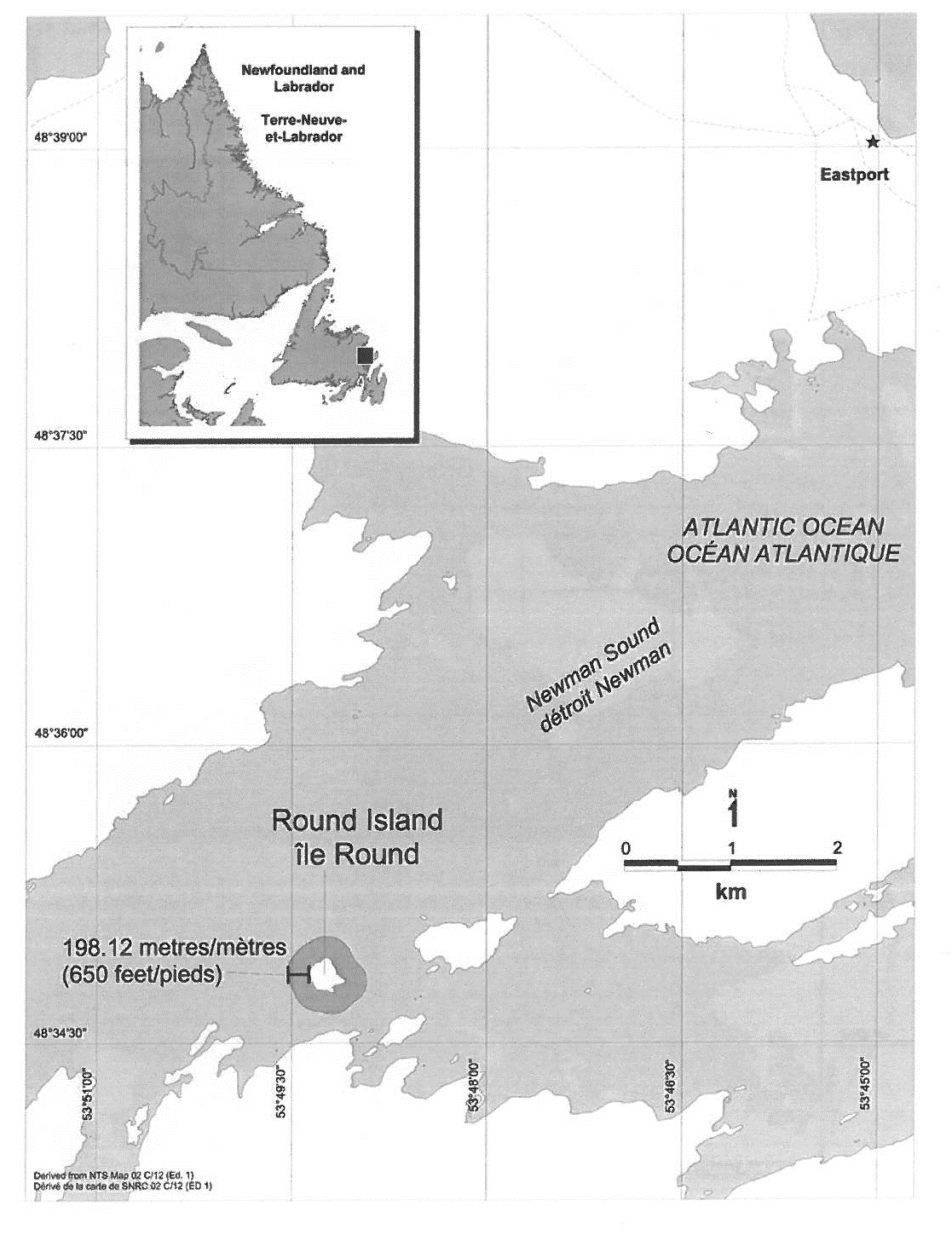
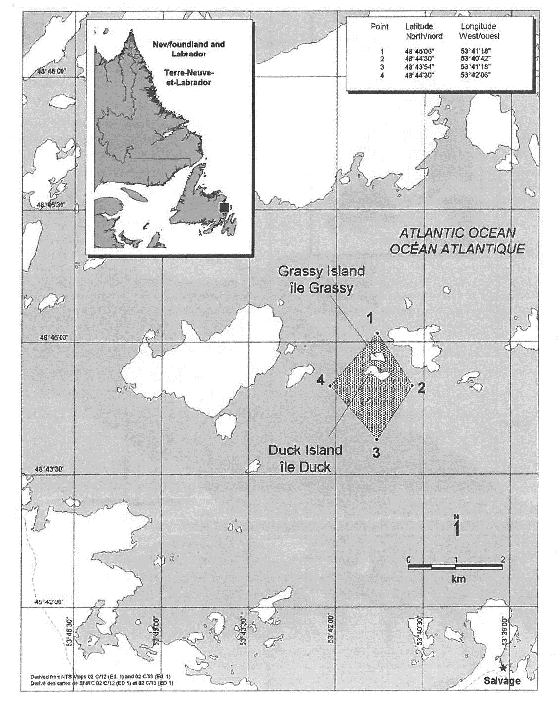
Regulatory Requirements for Vessels Operating in the Eastport Marine Protected Areas
•See Section 5A - General Regulatory Requirements for all Oceans Act Marine Protected Areas.
Guidelines for Vessels Operating in the Area (Year Round)
•Boaters are permitted to sail through the Marine Protected Areas, but are asked to take every precaution and exercise due diligence while operating a vessel near these waters.
•Any person involved in an incident within the Eastport MPAs that is likely to result in any prohibited activity shall, within two hours after its occurrence, report the incident to the Canadian Coast Guard.
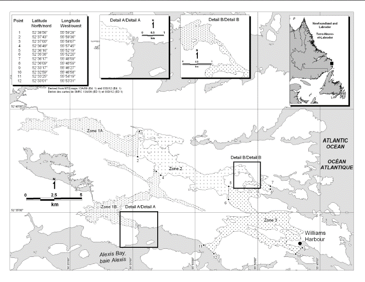
1.5Gilbert Bay Marine Protected Area
The Gilbert Bay Marine Protected Area was designated pursuant to the Oceans Act on September 26th, 2005. The full text of the regulations may be accessed in the Gilbert Bay Marine Protected Area Regulations.
The Regulations establish three management zones within the MPA:
oZone 1a and 1b (core protection zone): Zones 1a and 1b cover a combined area of 24.9 km2. These are critical areas for cod and for migrating salmon, char and trout, and they house pristine maerl beds.
oZone 2 and 3 (adaptive management zones): Zone 2 and 3 covers a combined area of 37.5 km2. They encompass important areas that cod use for spawning, feeding and migrating between the outer part of the bay in the summer and the inner part in the fall.
Coordinates
The Gilbert Bay Marine Protected Area is 62.4 km2, comprises the waters of Gilbert Bay that are within an area of the sea bounded by the low-water line of the bay and by the rhumb lines below, to their points of intersection with the low-water line. All geographic coordinates (latitude and longitude) are expressed in the North America Datum 1983 (NAD 83) geodetic reference system.
|
Point |
Latitude (North) |
Longitude (West) |
|
1 |
52° 38′ 56" |
55° 59′ 28" |
|
2 |
52° 37′ 43" |
55° 59′ 36" |
|
3 |
52° 37′ 00" |
55° 58′ 07" |
|
4 |
52° 36′ 49" |
55° 57′ 45" |
|
5 |
52° 36′ 16" |
55° 52′ 19" |
|
6 |
52° 35′ 38" |
55° 52′ 20" |
|
7 |
52° 36′ 17" |
55° 48′ 59" |
|
8 |
52° 36′ 09" |
55° 48′ 59" |
|
9 |
52° 33′ 17" |
55° 46′ 27" |
|
10 |
52° 32′ 59" |
55° 46′ 58" |
|
11 |
52° 33′ 25" |
55° 54′ 19" |
|
12 |
52° 33′ 01" |
55° 53′ 31" |
The Gilbert Bay Marine Protected Area is shown on the following map:
Regulatory Requirements for Vessels Operating in the Gilbert Bay Marine Protected Area
•See Section 5A - General Regulatory Requirements for all Oceans Act Marine Protected Areas.
•Specific requirements for the Gilbert Bay Marine Protected Area
•Zone 1 (core protection zone) – Recreational or commercial fishing for Atlantic cod is prohibited. Angling for Arctic char, salmon or trout, sealing and the Aboriginal food fishery are permitted. The maintenance, repair or removal of a wharf is permitted.
•Zone 2 – Recreational or commercial
fishing for Atlantic cod is prohibited. Recreational fishing
for any species other than Atlantic cod, sealing and the
Aboriginal food fishery are permitted. The construction,
maintenance, repair or removal of a wharf is permitted.
•Zone 3 – Commercial fishing for
Atlantic cod is prohibited. Recreational fishing for any
species, sealing and the Aboriginal food fishery are permitted.
The construction, maintenance, repair or removal of a wharf,
causeway or bridge is permitted.
Guidelines for Vessels Operating in the Area (Year Round)
•Boaters are permitted to sail through the Marine Protected Areas, but are asked to take every precaution and exercise due diligence while operating a vessel near these waters.
•Any person involved in an incident in the Gilbert Bay MPA that is likely to result in any prohibited activity shall, within two hours after its occurrence, report the incident to the Canadian Coast Guard.
1.6Basin Head Marine Protected Area
The Basin Head Marine Protected Area was designated pursuant the
Oceans Act on September 26th, 2005. The full
text of the regulations may be accessed in the Basin
Head Marine Protected Area Regulations.
The Basin Head MPA covers an area of 9 km2, which
includes 3 distinctive areas: the outer coast (zone 3), the
main basin (zone 2) and the inner channel (zone 1).The Basin
Head ecosystem is shallow, with an overall average depth of
less than 1 m above chart datum (Sharp et al. 2003). The deeper
basin is about 500 m in diameter and is attached to a shallower
channel (Northeast Arm) that is about 3 km long and up to 200 m
wide. The distinct strain of Irish moss is found only on
relatively firm, sandy substrates within this channel. Sandy
substrates are primarily found on shallow banks in the center
of the channel whereas muddy sediments often cover the
intertidal fringes and deeper channels. The mouth of the lagoon
and the first 100 m of the entrance channel are highly
energetic, with average tidal current speeds reaching 50 cm/s,
while in Northeast Arm, average current speeds rarely exceed 16
cm/s.
Coordinates
The Basin Head Marine Protected Area and the management zones coordinates are shown in the following map (geographic coordinates are expressed in the North America Datum 1983 (NAD 83) geodetic reference system). The management zones are as follows:
a.Zone 1, consisting of waters lying generally northeast
of a rhumb line connecting points at 46°23′20″ N, 62°06′10″ W
and 46°23′18″ N, 62°06′08″ W, that are within an area of the
sea bounded by the low-water line of the harbour and by the
rhumb line to its points of intersection with the low-water
line;
b.Zone 2, consisting of waters that are within an area
of the sea bounded by the low-water line of the harbour and by
the following rhumb lines to their respective points of
intersection with the low-water line, namely,
i.a line connecting points at 46°23′20″ N, 62°06′10″ W and 46°23′18″ N, 62°06′08″ W, and
ii.a line connecting points at 46°22′39″ N, 62°06′29″ W and 46°22′40″ N, 62°06′29″ W; and
c.Zone 3, consisting of waters that are within an area of the sea bounded by the low-water line of the Northumberland Straight and by the following rhumb lines, namely,
i.to its points of intersection with the low-water line, a line connecting points at 46°22′39″ N, 62°06′29″ W and 46°22′40″ N, 62°06′29″ W;
ii.to its point of intersection with the low-water line, a line connecting points at 46°23′51″ N, 62°04′30″ W and 46°22′55″ N, 62°04′02″ W;
iii.a line connecting points at 46°22′55″ N, 62°04′02″ W and 46°21′07″ N, 62°07′36″ W, and
iv.to its point of intersection with the low-water line, a line connecting points at 46°21′07″ N, 62°07′36″ W and 46°22′04″ N, 62°08′04″ W.
|
Point |
Latitude (North) |
Longitude (West) |
|
1 |
46°23’20” N |
62°06’10” W |
|
2 |
46°23’18” N |
62°06’08” W |
|
3 |
46°22’39” N |
62°06’29” W |
|
4 |
46°22’40” N |
62°06’29” W |
|
5 |
46°23’51” N |
62°04’30” W |
|
6 |
46°22’55” N |
62°04’02” W |
|
7 |
46°21’07” N |
62°07’36” W |
|
8 |
46°22’04” N |
62°08’04” W |
|
9 |
46°22’56” N |
62°06’39” W |
|
10 |
46°22’56” N |
62°06’34” W |
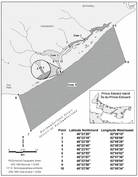
Regulatory Requirements for Vessels Operating in the Basin Head Marine Protected Area
•See
Section 5A - General
Regulatory Requirements for all Oceans Act Marine Protected
Areas.
•Specific
requirements for the Basin Head Marine Protected Areas
oZone 1 (The inner
channel) – This zone has the highest level of protection.
Swimming, diving, use of motorized vessels, and fishing are not
permitted.
oZone 2 (The
lagoon) – This zone acts as a buffer zone for the more
sensitive Zone 1 area. Swimming and diving, and fishing (with
licence) is allowed but the use of a motorized vessel is only
permitted south of the rhumb line connecting points 9 and 10
(see map above) solely for the purpose of transiting Zone 2 in
order to launch a vessel from, or land it at, a boat
launch.
oZone 3 (The outer
coast) - Swimming, diving, fishing (with licence), and the use
of motorized vessels are permitted in this zone.
oAny person involved in an incident
in the Basin Head Marine Protected Area that is likely to
result in any prohibited activity shall, within two hours after
its occurrence, report the incident to the Canadian Coast
Guard.
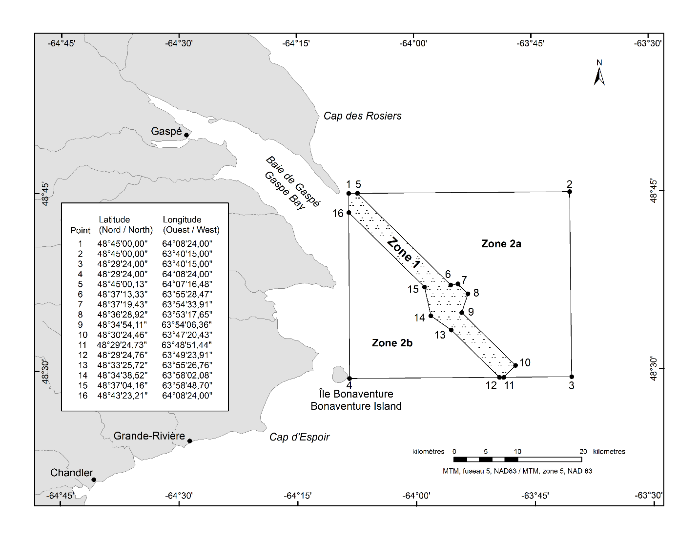
1.7The Banc-des-Américains Marine Protected Area
The Banc-des-Américains Marine Protected Area Regulations, under the Oceans Act, were published on March 6, 2019. The full text of the regulations designating this area can be found in the Banc-des-Américains Marine Protected Area Regulations.
These Regulations constitute the federal portion of the joint Banc-des-Américains Marine Protected Area project, created under the Canada-Quebec collaborative agreement for establishing a marine protected areas network in Quebec and the specific Agreement for this project, signed on March 4, 2019.
Coordinates
The Regulations establish two management zones within the MPA:
Zone 1 (core protection zone): This zone covers an area of 127 km2. It covers all of the rocky ridges associated with the American Bank, as well as their escarpments and the surrounding sea floor.
Zones 2a and 2b (adaptive management zone): These zones cover an area of 873 km2 and include almost 90% of the MPA. They include the deep plains on either side of the American Bank.
The Banc-des-Américains Marine Protected Area (1,000 km2) is bounded by rhumb lines connecting the following geographical coordinates (points 1 to 16) [North American Datum 1983 (NAD 83)]. Zone 1 is bounded by a series of rhumb lines drawn from point 1 to point 5, then to points 6 to 16 and then back to point 1. Zone 2a is bounded by a series of rhumb lines drawn from point 5 to point 2, then to point 3, then to point 11, then to point 10, then to point 9, then to point 8, then to point 7, then to point 6 and then back to point 5. Zone 2b is bounded by a series of rhumb lines drawn from point 16 to point 15, then to point 14, then to point 13, then to point 12, then to point 4 and then back to point 16.
|
Point |
Latitude (North) |
Longitude (West) |
|
1 |
48° 45' 00.00ʺ |
64° 08' 24.00ʺ |
|
2 |
48° 45' 00.00ʺ |
63° 40' 15.00ʺ |
|
3 |
48° 29' 24.00ʺ |
63° 40' 15.00ʺ |
|
4 |
48° 29' 24.00ʺ |
64° 08' 24.00ʺ |
|
5 |
48° 45' 00.13ʺ |
64° 07' 16.48ʺ |
|
6 |
48° 37' 13.33ʺ |
63° 55' 28.47ʺ |
|
7 |
48° 37' 19.43ʺ |
63° 54' 33.91ʺ |
|
8 |
48° 36' 28.92ʺ |
63° 53' 17.65ʺ |
|
9 |
48° 34' 54.11ʺ |
63° 54' 06.36ʺ |
|
10 |
48° 30' 24.46ʺ |
63° 47' 20.43ʺ |
|
11 |
48° 29' 24.73ʺ |
63° 48' 51.44ʺ |
|
12 |
48° 29' 24.76ʺ |
63° 49' 23.91ʺ |
|
13 |
48° 33' 25.72ʺ |
63° 55' 26.76ʺ |
|
14 |
48° 34' 38.52ʺ |
63° 58' 02.08ʺ |
|
15 |
48° 37' 04.16ʺ |
63° 58' 48.70ʺ |
|
16 |
48° 43' 23.21ʺ |
64° 08' 24.00ʺ |
The Banc-des-Américains Marine Protected Area is shown in the map below:
Regulatory Requirements for Vessels Operating in the Banc-des-Américains Marine Protected Area
•See
Section 5A – General
Regulatory Requirements for all Oceans Act Marine Protected
Areas.
•Specific
requirements for the Banc-des-Américains Marine Protected
Area
oAll activities related to shipping and transportation continue to be allowed within the MPA. However, anchoring of vessels is not permitted in Zone 1. In addition, discharge of sewage and release of grey water (as defined in the Vessel Pollution and Dangerous Chemicals Regulations) from vessels with a gross tonnage of 400 tonnes or more, or certified to carry 15 or more passengers, are prohibited in the MPA.
Guidelines for Vessels Operating in the Area (Year Round)
It is recommended that the following guidelines be followed to safeguard the Marine Protected Area and its resources.
Marine Mammal Protection
1.Vessels
must comply with all relevant provisions of the Marine Mammal
Regulations under the Fisheries Act. Further
details can be found in Section 5
– General Guidelines for
Aquatic Species at Risk and Important Marine Mammal
Areas.
2.Report
all collisions with marine mammals or turtles, entanglements of
marine mammals or turtles and animals in distress or those
found dead by calling the toll-free number of the Réseau
québécois d'urgences pour les mammifères marins
(1-877-722-5346). Before releasing a whale carcass caught in
fishing gear, it is important to contact the emergency service.
3Report sightings of North Atlantic right whales (NARW) in near real-time (i.e., on the day of the sighting or as soon as possible) to DFO.GLFWhales-BaleinesGLF.MPO@dfo-mpo.gc.ca. Image-confirmed sightings will be used to inform management actions and will appear on the online Whale Watch platform.
4If you
already have a data-sharing agreement with the Government of
Canada to report sightings directly to Whale Watch in near
real-time, please follow those reporting protocols rather than
sending your sightings to the email address above, unless this is
not possible (due to technical issues, for example). In that
case, sightings should be reported as soon as possible by email
to
DFO.GLFWhales-BaleinesGLF.MPO@dfo-mpo.gc.ca.
5When
reporting near real-time NARW sightings, please provide the GPS
position (latitude and longitude), date and time of sighting,
species observed, number of animals, behavior of animals
observed (e.g., feeding, moving, diving), and any
photographs/videos that were taken.
N.B. In this document, the term “Banc-des-Américains” is used to refer to the marine area that is designated as a Marine Protected Area, while the term “American Bank” is used to refer to the underwater bank (i.e. the physical structure) in the Gulf of St. Lawrence.
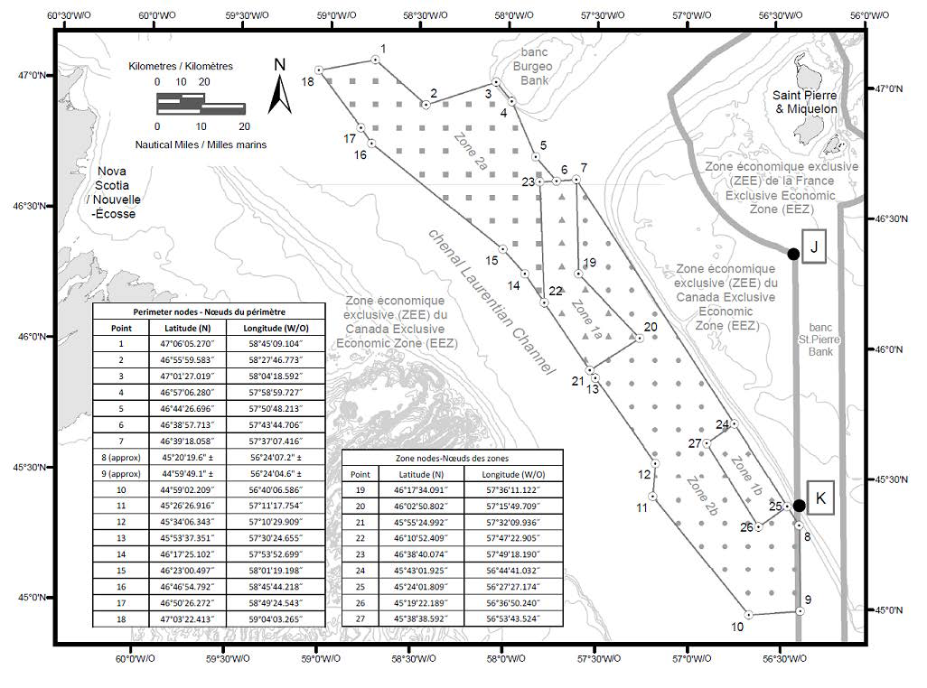
1.8Laurentian Channel Marine Protected Area
The Laurentian Channel Marine Protected Area Regulations, under the Oceans Act, were published on May 1, 2019. The full text of the regulations designating this area can be found in the Laurentian Channel Marine Protected Area Regulations.
The Regulations establish two management zones within the MPA:
•Zone 1a and 1b (core protection zones): Zone 1a covers an area of 1,495 km2 and zone 1b covers an area of 612 km2. These zones consist of sensitive benthic areas with the highest level of protection with the MPA.
•Zones 2a and 2b (adaptive management zones): These zones cover a combined area of 9,473 km2 and include almost 82% of the MPA. They are the adaptive management zones which accommodate activities compatible with the conservation objectives.
Coordinates
The Laurentian Channel Marine Protected Area (11,580 km2) includes the seabed, the subsoil to a depth of five metres, and the water column above the seabed. It is bounded by rhumb lines connecting the following geographical coordinates (perimeter node points 1 to 18) and contains two core protection zones (zone 1a and 1b):
a.Zone 1a, which is bounded by a series of rhumb lines
drawn from point 6 to point 7, then to points 19 to 23 and then
back to point 6;
b.Zone 1b, which is bounded by a series of rhumb lines
drawn from points 24 to 27 and then back to point 24;
c.Zone 2a, which is bounded by a series of rhumb lines
drawn from points 1 to 6, then to point 23, then to point 22,
then to points 14 to 18 and then back to point 1; and
d.Zone 2b, which is bounded by
i.a series of rhumb lines drawn from point 7 to point
24, then to point 27, then to point 26, then to point 25 and
then to point 8,
ii.a geodesic line drawn from point 8 to point 9, and
iii.a series of rhumb lines drawn from points 9 to 13, then to point 21, then to point 20, then to point 19 and then back to point 7.
The Laurentian Channel Marine Protected Areas and the management zones coordinates are shown in the following map (geographic coordinates are expressed in the North America Datum 1983 (NAD 83) geodetic reference system).
Perimeter nodes
|
Point |
Latitude (North) |
Longitude (West) |
|
1 |
47°06'05.270" |
58°45'09.104" |
|
2 |
46°55'59.583" |
58°27'46.773" |
|
3 |
47°01'27.019" |
58°04'18.592" |
|
4 |
46°57'06.280" |
57°58'59.727" |
|
5 |
46°44'26.696" |
57°50'48.213" |
|
6 |
46°38'57.713" |
57°43'44.706" |
|
7 |
46°39'18.058" |
57°37'07.416" |
|
8 (approx) |
45°20'19.6" ± |
56°24'07.2" ± |
|
9 (approx) |
44°59'49.1" ± |
56°24'04.6" ± |
|
10 |
44°59'02.209" |
56°40'06.586" |
|
11 |
45°26'26.916" |
57°11'17.754" |
|
12 |
45°34'06.343" |
57°10'29.909" |
|
13 |
45°53'37.351" |
57°30'24.655" |
|
14 |
46°17'25.102" |
57°53'52.699" |
|
15 |
46°23'00.497" |
58°01'19.198" |
|
16 |
46°46'54.792" |
58°45'44.218" |
|
17 |
46°50'26.272" |
58°49'24.543" |
|
18 |
47°03'22.413" |
59°04'03.265" |
Zone nodes
|
Point |
Latitude (North) |
Longitude (West) |
|
19 |
46°17'34.091" |
57°36'11.122" |
|
20 |
46°02'50.802" |
57°15'49.709" |
|
21 |
45°55'24.992" |
57°32'09.936" |
|
22 |
46°10'52.409" |
57°47'22.905" |
|
23 |
46°38'40.074" |
57°49'18.190" |
|
24 |
45°43'01.925" |
56°44'41.032" |
|
25 |
45°24'01.809" |
56°27'27.174" |
|
26 |
45°19'22.189" |
56°36'50.240" |
|
27 |
45°38'38.592" |
56°53'43.524" |
Regulatory Requirements for Vessels Operating in the Laurentian Channel Marine Protected Area
•See
Section 5A – General
Regulatory Requirements for all Oceans Act Marine Protected
Areas.
•Specific
Requirements for Laurentian Channel Marine Protected
Area
oNavigation of vessels may be
carried out provided that there is no anchoring in Zone 1a or
1b.
oVessels must avoid discharge of
ballast water in the Marine Protected Area. However, under
certain circumstances (Ballast Water Regulations, and
List of Canada’s Designated Alternate Ballast Water
Exchange Areas and Fresh Waters (TP 13617E)), vessels when
navigating on transoceanic voyages may conduct ballast water
exchanges in the portion of the Marine Protected Area that
overlaps with the Laurentian Channel, where the water depth is
at least 300 m, and only from December 1 to
May 1. Please see the Ballast Water Regulations
for additional guidance (including exceptions) on ballast water
management in and around the Marine Protected Area.
othe laying, maintenance and repair of cables in Zones 2a and 2b may be carried out, provided that it is not likely to destroy the habitat of any living marine organism in the Marine Protected Area
Environmental Emergencies
oIn case of environmental emergencies (such as collisions with marine mammals and turtle entanglements, or oil/chemical spills) please contact: Canadian Coast Guard at Environmental Emergencies 1 709 772 2083 or Canadian Coast Guard Radio (VHF 16)
2.Marine Protected Areas in the Pacific Region of Canada
The following section provides information on Marine Protected Areas that have been designated under the Oceans Act in Canada’s Pacific Region.
2.1SG̲áan K̲ínghlas-Bowie Seamount Marine Protected Area
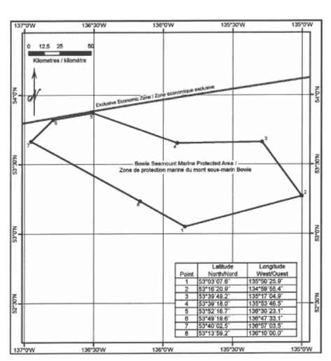
The SG̲áan K̲ínghlas-Bowie Seamount Marine Protected Area was designated pursuant to the Oceans Act on April 17th, 2008. The full text of the regulations may be accessed in the SG̲áan K̲ínghlas-Bowie Seamount Marine Protected Area Regulations.
Coordinates
The SG̲áan K̲ínghlas-Bowie Seamount is located 180 km west of Haida Gwaii on Canada’s Pacific Coast, and is comprised of Bowie, Hodgkins and Davidson Seamounts of the Kodiak-Bowie Seamount chain. The SG̲áan K̲ínghlas-Bowie Seamount Marine Protected Area is bounded by rhumb lines connecting the following geographical coordinates. All geographic coordinates (latitude and longitude) are expressed in the North America Datum 1983 (NAD 83) geodetic reference system.
|
Point |
Latitude (North) |
Longitude (West) |
|
1 |
53º 03' 07.6" |
135º 50' 25.9" |
|
2 |
53º 16' 20.9" |
134º 59' 55.4" |
|
3 |
53º 39' 49.2" |
135º 17' 04.9" |
|
4 |
53º 39' 18.0" |
135º 53' 46.5" |
|
5 |
53º 52' 16.7" |
136º 30' 23.1" |
|
6 |
53º 49' 19.6" |
136º 47' 33.1" |
|
7 |
53º 40' 02.5" |
136º 57' 03.5" |
|
8 |
53º 13' 59.2" |
136º 10' 00.0" |
The SG̲áan K̲ínghlas-Bowie Seamount Marine Protected Area is shown in the map below:
Regulatory Requirements for Vessels Operating in the SG̲áan K̲ínghlas-Bowie Seamount Marine Protected Area
•See
Section 5A - General
Regulatory Requirements for all Oceans Act Marine Protected
Areas.
•Specific
Requirements for the SG̲áan K̲ínghlas - Bowie
Seamount Marine Protected Area
oVessels must avoid discharge of
ballast water in the Marine Protected Area or within 50
nautical miles of the SG̲áan K̲ínghlas-Bowie Seamount pinnacle
(Ballast Water Regulations). Please see the
Ballast Water Regulations for additional guidance
(including exceptions) on ballast water management in and
around the Marine Protected Area.
oAny person involved in an incident that is likely to
result in any prohibited activity shall, within two hours
after its occurrence, report the incident to the Canadian Coast
Guard.
oEvery person involved in an accident that is likely to result in any disturbance, damage, destruction or removal prohibited under section 3 shall, within two hours after its occurrence, report the accident to the Canadian Coast Guard.
2.2Hecate Strait and Queen Charlotte Sound Glass Sponge Reefs Marine Protected Areas
The Hecate Strait and Queen Charlotte Sound Glass Sponge Reefs Marine Protected Areas were designated pursuant to the Oceans Act on February 13, 2017. The full text of the regulations may be accessed in the Hecate Strait and Queen Charlotte Sound Glass Sponge Reefs Marine Protected Areas Regulations.
Coordinates
The Hecate Strait and Queen Charlotte Sound Glass Sponge Reefs Marine Protected Areas consist of four individual sponge reefs located between Haida Gwaii and the mainland of British Columbia. The Northern Reef, the Central Reefs (Zone A and B), and the Southern Reef areas all have a core protection zone (CPZ) (two in the Central Reefs), a vertical adaptive management zone, and an adaptive management zone. The CPZ consists of the seabed, the subsoil to a depth of 20m and the water column above the seabed to a depth of 100 m below the sea surface for the Northern Reef, 120 m for the Central Reefs, and 146 m for the Southern Reef. The vertical adaptive management zones consist of the water column that extends above the CPZ to the sea surface. The adaptive management zones consist of the seabed, subsoil and waters of the MPA that are not part of the CPZ or the vertical adaptive management zones.
The three areas are bounded by rhumb lines connecting the geographical coordinates presented in the following map, expressed in the North America Datum 1983 (NAD 83) geodetic reference system.
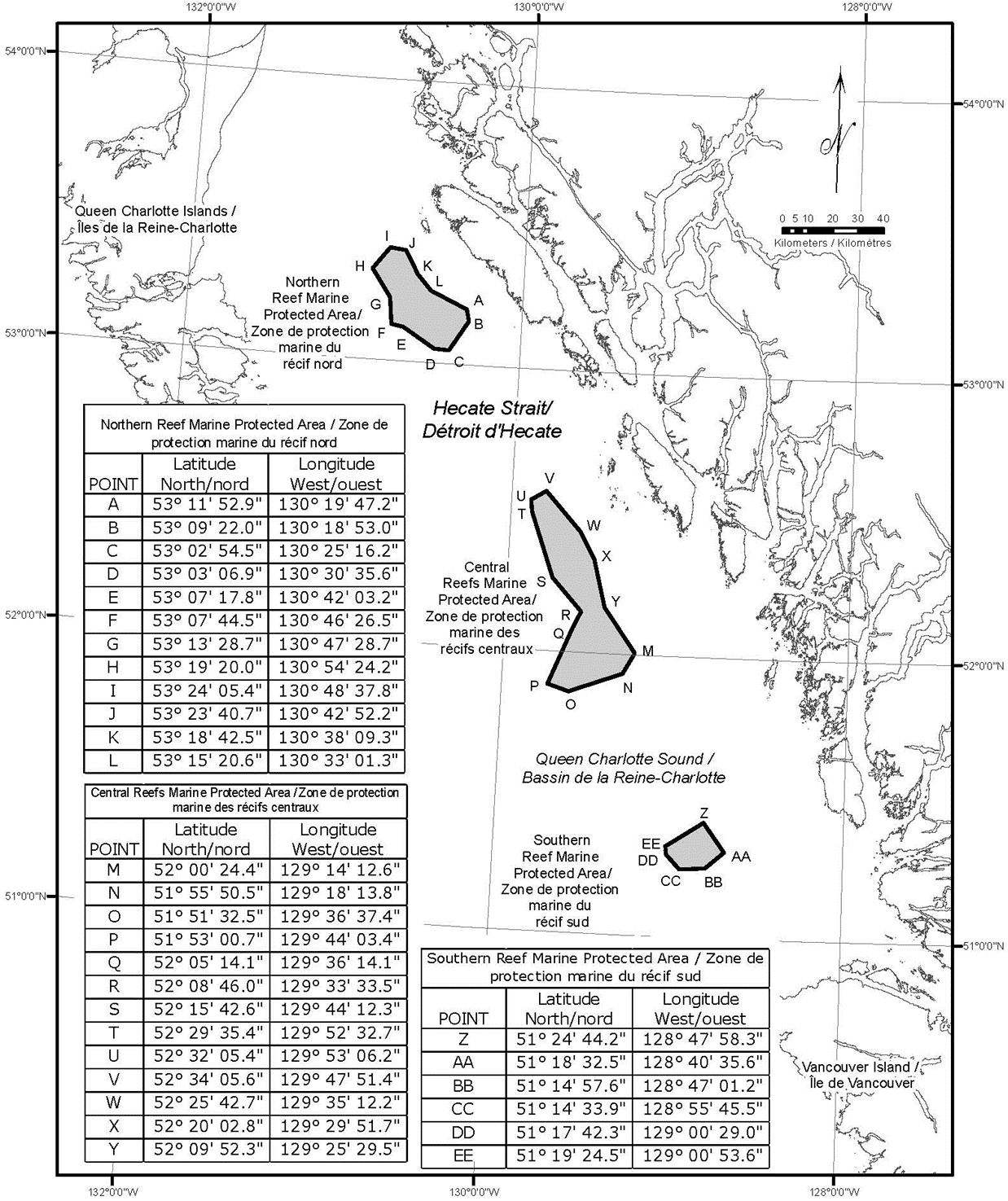
Regulatory Requirements for Vessels Operating in the Hecate Strait and Queen Charlotte Sound Glass Sponge Reefs Marine Protected Areas:
•See
Section 5A, General Regulatory Requirements for
all Oceans
Act Marine Protected Areas.
•Specific
Requirements for the Hecate Strait and Queen Charlotte Sound
Glass Sponge Reefs Marine Protected Areas:
oNo anchor is permitted to enter a core protection zone
oVessels must avoid exchanging ballast within the MPA
Coordinates for the Marine Protected Areas and their core protection zone (CPZ) are found in the maps below:
Northern Reef Marine Protected Area

Central Reefs Marine Protected Area

Southern Reef Marine Protected Area

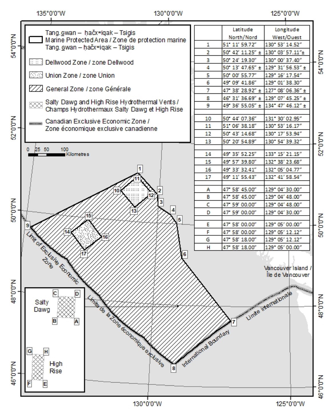
2.3 Tang.ɢwan — ḥačxʷiqak — Tsig̱is Marine Protected Area
The Tang.ɢwan — ḥačxʷiqak — Tsig̱is Marine Protected Area was designated pursuant to the Oceans Act on June 19th, 2024. The full text of the regulations may be accessed in the Tang.ɢwan — ḥačxʷiqak — Tsigis Marine Protected Area Regulations.
Coordinates
The Tang.ɢwan — ḥačxʷiqak — Tsig̱is Marine Protected Area is located approximately 150 km from the coast of Vancouver Island. The Marine Protected Area is approximately 133, 017km2 and includes the water, subsoil, and seafloor. The Marine Protected Area is bounded by the following lines:
a.a rhumb line drawn from point 1 to point 2, with point
2 being located on the western boundary of the Scott Islands
Protected Marine Area, as described in Schedule 1 to
the Scott Islands Protected Marine Area Establishment
Order;
b.a rhumb line drawn southerly following the western
boundary of the Scott Islands Protected Marine Area, as
described in Schedule 1 to the Scott Islands Protected
Marine Area Establishment Order, to point 3;
c.a rhumb line southeasterly following the boundary of
the Scott Islands Protected Marine Area, as described in
Schedule 1 to the Scott Islands Protected Marine Area
Establishment Order, to point 4;
d.a series of rhumb lines drawn from point 4 to point 5
and then to point 6;
e.a rhumb line to a point on the international boundary
between Canada and the United States intersecting a rhumb line
drawn from point 6 to point 7;
f.a line southwesterly following the international
boundary between Canada and the United States to point 8, on
the seaward limit of the exclusive economic zone of Canada; and
g.a line northwesterly following the seaward limit of the exclusive economic zone of Canada to a point intersecting a rhumb line drawn from point 1 to point 9, and then a rhumb line back to point 1.
|
Point |
Latitude (North) |
Longitude (West) |
|
1 |
51° 11′ 59.72" |
130° 53′ 14.52" |
|
2 |
+/- 50° 42′ 11.25" |
+/- 130° 03′ 57.11" |
|
3 |
50° 24′ 19.30" |
130° 00′ 37.40" |
|
4 |
+/- 50° 13′ 47.65" |
+/- 129° 31′ 56.53" |
|
5 |
50° 00′ 55.77" |
129° 16′ 17.54" |
|
6 |
49° 09′ 41.86" |
129° 01′ 38.30" |
|
7 |
+/- 47° 38′ 28.92" |
+/- 127° 08′ 06.36" |
|
8 |
+/- 46° 31′ 36.69" |
+/- 129° 07′ 45.25" |
|
9 |
+/- 49° 36′ 55.05" |
+/- 134° 47′ 46.12" |
|
10 |
50° 44′ 07.36" |
131° 30′ 02.95" |
|
11 |
51° 06′ 38.18" |
130° 53′ 16.17" |
|
12 |
50° 43′ 14.68" |
130° 17′ 53.94" |
|
13 |
50° 20′ 54.89" |
130° 54′ 39.32" |
|
14 |
49° 35′ 52.25" |
133° 15′ 21.15" |
|
15 |
49° 57′ 39.80" |
132° 38′ 23.68" |
|
16 |
49° 33′ 32.41" |
132° 05′ 04.77" |
|
17 |
49° 11′ 55.43" |
132° 41′ 58.54" |
|
A |
47° 58′ 45.00" |
129° 04′ 30.00" |
|
B |
47° 58′ 45.00" |
129° 04′ 48.00" |
|
C |
47° 59′ 00.00" |
129° 04′ 48.00" |
|
D |
47° 59′ 00.00" |
129° 04′ 30.00" |
|
E |
47° 58′ 00.00" |
129° 05′ 00.00" |
|
F |
47° 58′ 00.00" |
129° 05′ 12.12" |
|
G |
47° 58′ 18.00" |
129° 05′ 12.12" |
|
H |
47° 58′ 18.00" |
129° 05′ 00.00" |
 Regulatory
Requirements for Vessels Operating in the Tang.ɢwan —
ḥačxʷiqak — Tsig̱is Marine Protected Area
Regulatory
Requirements for Vessels Operating in the Tang.ɢwan —
ḥačxʷiqak — Tsig̱is Marine Protected Area
•See Section 5A - General Regulatory Requirements for all Oceans Act Marine Protected Areas
3.Marine Protected Areas in the Canadian Arctic
The following section provides information on Marine Protected Areas that have been designated under the Oceans Act in the Canadian Arctic.
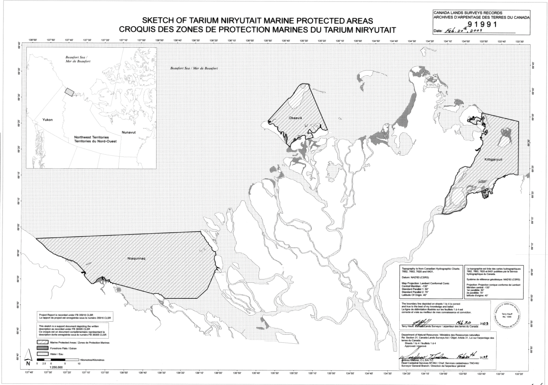
3.1The Tarium Niryutait Marine Protected Areas
The Tarium Niryutait Marine Protected Areas were designated pursuant to the Oceans Act on August 25th, 2010. The full text of the regulations may be accessed in the Tarium Niryutait Marine Protected Areas Regulations.
Coordinates
The Tarium Niryutait Marine Protected Areas consist of three areas of the Mackenzie Bay: Okeevik, Kittigaryuit and Niaqunnaq. The three areas are bounded by straight lines and lines following the Low Water Line which connect the following geographical coordinates [Universal Transverse Mercator (UTM) North America Datum 1983 (NAD 83)]. Reference is FB #36305 metes and bounds description in English and French for Tarium Niryutait Marine Protected Area Beaufort Sea Niaqunnaq Okeevik, Kittigaryuit Project 2006-18-091 Surveyor Terry Hauff.
Okeevik Sub Area
|
Point |
Latitude (North) |
Longitude (West) |
|
1 |
69° 38′ 19" |
135° 25′ 09" |
|
2 |
69° 38′ 03" |
135° 25′ 11" |
|
3 |
69° 37′ 46" |
135° 24′ 52" |
|
4 |
69° 29′ 49" |
135° 12′ 49" |
|
5 |
69° 30′ 45" |
135° 16′ 56" |
|
6 |
69° 29′ 26" |
135° 18′ 53" |
|
7 |
69° 29′ 23" |
135° 19′ 06" |
|
8 |
69° 28′ 07" |
135° 20′ 25" |
|
9 |
69° 27′ 36" |
135° 24′ 25" |
|
10 |
69° 25′ 51" |
135° 32′ 27" |
|
11 |
69° 26′ 32" |
135° 34′ 54" |
|
12 |
69° 28′ 21" |
135° 35′ 24" |
|
13 |
69° 28′ 35" |
135° 36′ 40" |
|
14 |
69° 28′ 39" |
135° 37′ 58" |
|
15 |
69° 30′ 34" |
135° 45′ 54" |
|
16 |
69° 35′ 18" |
135° 35′ 42" |
|
17 |
69° 36′ 00" |
135° 22′ 10" |
|
18 |
69° 34′ 40" |
135° 20′ 09" |
|
19 |
69° 34′ 00" |
135° 20′ 09" |
|
20 |
69° 34′ 00" |
135° 27′ 39" |
|
21 |
69° 36′ 00" |
135° 27′ 39" |
|
22 |
69° 27′ 00" |
135° 31′ 11" |
|
23 |
69° 27′ 00" |
135° 34′ 45" |
Kittigaruit Sub Area
|
Point |
Latitude (North) |
Longitude (West) |
|
1 |
69° 35′ 10" |
133° 48′ 26" |
|
2 |
69° 34′ 00" |
133° 28′ 00" |
|
3 |
69° 23′ 37" |
133° 26′ 40" |
|
4 |
69° 20′ 34" |
133° 40′ 37" |
|
5 |
69° 19′ 05" |
133° 42′ 21" |
|
6 |
69° 19′ 01" |
133° 42′ 31" |
|
7 |
69° 20′ 39" |
133° 43′ 20" |
|
8 |
69° 16′ 42" |
133° 54′ 54" |
|
9 |
69° 15′ 20" |
134° 06′ 53" |
|
10 |
69° 16′ 33" |
134° 05′ 56" |
|
11 |
69° 20′ 42" |
134° 02′ 44" |
|
12 |
69° 24′ 00" |
133° 59′ 10" |
|
13 |
69° 24′ 34" |
133° 53′ 49" |
|
14 |
69° 28′ 21" |
133° 48′ 15" |
|
15 |
69° 28′ 02" |
133° 50′ 59" |
|
16 |
69° 33′ 20" |
133° 47′ 29" |
|
17 |
69° 34′ 33" |
133° 47′ 42" |
|
18 |
69° 32′ 55" |
133° 51′ 09" |
|
19 |
69° 32′ 56" |
133° 51′ 54" |
|
20 |
69° 33′ 46" |
133° 55′ 48" |
|
21 |
69° 33′ 46" |
133° 55′ 31" |
Niaqunnaq Sub Area
|
Point |
Latitude (North) |
Longitude (West) |
|
1 |
69° 08′ 00" |
136° 16′ 44" |
|
2 |
69° 04′ 25" |
136° 07′ 45" |
|
3 |
69° 03′ 43" |
136° 07′ 08" |
|
4 |
69° 01′ 19" |
136° 04′ 45" |
|
5 |
69° 01′ 14" |
136° 04′ 45" |
|
6 |
69° 00′ 57" |
136° 05′ 42" |
|
7 |
69° 00′ 12" |
136° 07′ 08" |
|
8 |
68° 57′ 00" |
136° 10′ 00" |
|
9 |
68° 55′ 00" |
136° 15′ 00" |
|
10 |
68° 54′ 22" |
136° 31′ 50" |
|
11 |
68° 55′ 00" |
136° 38′ 33" |
|
12 |
68° 56′ 15" |
137° 00′ 41" |
|
13 |
68° 56′ 29" |
137° 03′ 03" |
|
14 |
68° 55′ 48" |
137° 11′ 00" |
|
15 |
68° 57′ 50" |
137° 16′ 40" |
|
16 |
68° 59′ 20" |
137° 21′ 30" |
|
17 |
69° 03′ 09" |
137° 44′ 54" |
The Tarium Niryutait Marine Protected Areas are shown in the map below:
Regulatory Requirements for Vessels Operating in the Tarium Niryutait Marine Protected Areas
•See Section 5A - General Regulatory Requirements for all Oceans Act Marine Protected Areas.
Regulatory Protection Measures for Tarium Niryutait Marine Protected Areas
•Pursuant to the Oceans Act, the Regulations set out a general prohibition within the boundaries of the Marine Protected Areas, prohibiting any activities that will or are likely to disturb, damage, destroy or remove any living marine organism or any part of its habitat from the areas. Any accident within the Tarium Niryutait Marine Protected Areas must be reported within two hours after its occurrence, to the Canadian Coast Guard.
Other Requirements Applying in the Area
oIn the spirit of the Inuvialuit
Final Agreement, it is forbidden for ships to approach the
traditional marine mammal harvest grounds, or to approach
marine mammals unless they are directly associated with the
traditional harvest of these animals. Information regarding the
traditional harvest can be gained from the community Hunters and
Trappers Committees: Aklavik HTC aklavikahtc@gmail.com,
hunteraklavik@gmail.com,
(867) 978-2723; Inuvik HTC, inuvikhtc@hotmail.com,
(867) 777-2478; Tuktoyaktuk HTC, tuk.htc@outlook.com,
(867) 340-0057 or the Fisheries Joint Management
Committee (fjmc-rp@jointsec.nt.ca).
oFor marine wildlife sightings and
incidents such as collisions that occur outside the Marine
Protected Areas or for any situation involving a marine mammal
that is dead or in trouble, contact Fisheries and Oceans
Canada, Inuvik office at (867) 777-7500.
oAs per the Marine Mammal Regulations (2018), pursuant to the Fisheries Act, reporting of accidental contact with marine mammals is required.
Voluntary Guidelines for Ships Operating in the Areas
The following procedures are recommended year round in order to
safeguard the Marine Protected Areas and its resources.
Vessels should adhere to the following measures for safety
reasons and to ensure marine mammal protection:
•It is strongly advised that commercial vessels remain in the community supply routes. These routes are generally marked by Canadian Coast Guard buoys and they should be followed whenever possible.
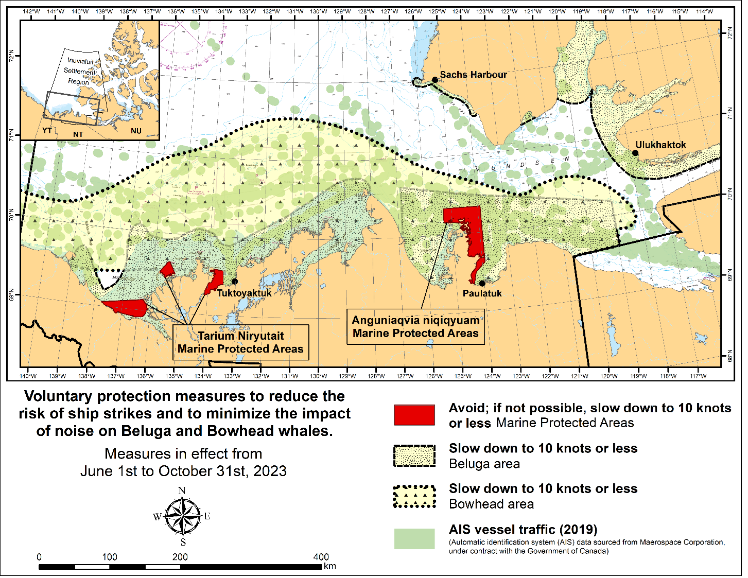
The following measures are in effect from June 1st to October 31st. See map
below.
These measures apply to merchant vessels, cruise ships, small
vessels and adventure craft within the boundaries of the Marine
Protected Areas and the additional identified areas to prevent
collisions with whales and to mitigate the underwater noise
generated by the vessels. These measures should only be taken
when they will not jeopardize navigational safety.
Avoid (red area): To reduce the risk of underwater noise disturbance and collisions with whales within the Marine Protected Areas, vessels should avoid transiting through the Marine Protected Areas if possible. If passage through this area is necessary, vessels should slow down to a speed not exceeding 10 knots over the ground and post additional lookouts such as a marine mammal observer in order to increase the chances of seeing the whales and thus taking necessary measures to avoid them. If bypassing the whales is not possible, slow down and wait for the animals to move away to a distance greater than 400 metres (0.215 nautical miles) before resuming original speed not exceeding 10 knots over the ground. It is more difficult to see the animals in rain, fog, or in rough sea states, therefore increased caution is recommended.
Slow down to 10 knots over the ground or less (yellow area): To reduce the risk of underwater noise disturbance and collisions with whales within these areas, it is recommended that vessels should slow down to a speed not exceeding 10 knots over the ground, navigate within the marked community supply channels and post additional lookouts.
These voluntary measures are secondary to rights under the Inuvialuit Final Agreement.
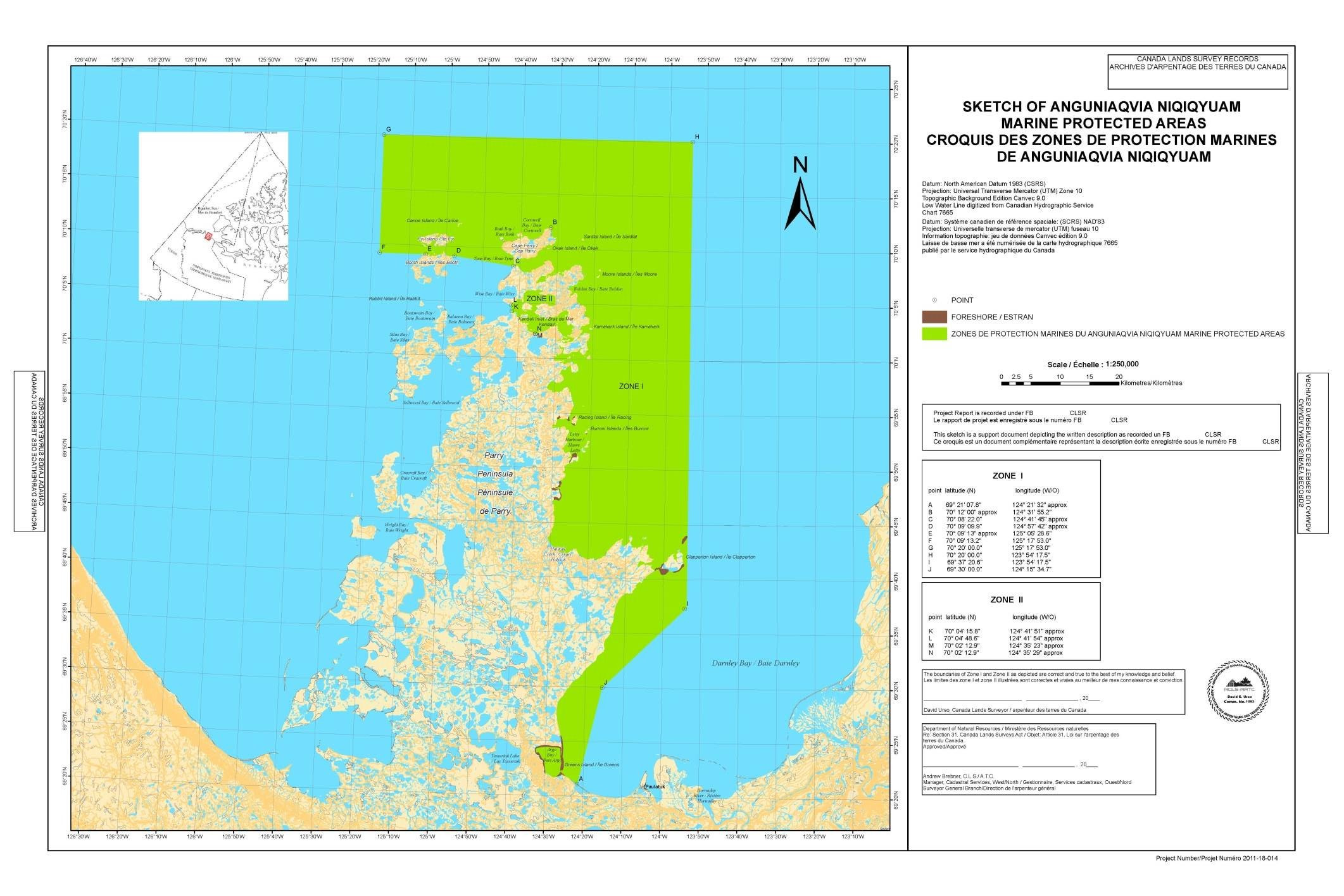
3.2The Anguniaqvia Niqiqyuam Marine Protected Areas
The Anguniaqvia Niqiqyuam Marine Protected Areas were designated pursuant to the Oceans Act on November 16th, 2016. The full text of the regulations may be accessed in the Anguniaqvia Niqiqyuam Marine Protected Areas Regulations.
Coordinates
The Anguniaqvia Niqiqyuam Marine Protected Areas consist of two areas in Darnley Bay and Amundsen Gulf in the Beaufort Sea: Zone 1 and Zone 2. The areas consist of the seabed, the subsoil to a depth of five metres and the water column, including the sea ice. The two areas are bounded by straight lines and lines following the Low Water Line which connect the following geographical coordinates [Universal Transverse Mercator (UTM) North America Datum 1983 (NAD 83)]. Reference is Canada Lands Surveys record F.B. 40812 CLSR NT.
Zone 1
|
Point |
Latitude (North) |
Longitude (West) |
|
A |
69° 21’ 07.8” |
124° 21’ 32” approx |
|
B |
70° 12’ 00” approx |
124° 31’ 55.2” |
|
C |
70° 08’ 22.0” |
124° 41’ 45” approx |
|
D |
70° 09’ 09.9” |
124° 57’ 42” approx |
|
E |
70° 09’ 13” approx |
125° 05’ 28.6” |
|
F |
70° 09’ 13.2” |
125° 17’ 53.0” |
|
G |
70° 20’ 00.0” |
125° 17’ 53.0” |
|
H |
70° 20’ 00.0” |
123° 54’ 17.5” |
|
I |
69° 37’ 20.6” |
123° 54’ 17.5” |
|
J |
69° 30’ 00.0” |
124° 15’ 34.7” |
Zone 2
|
Point |
Latitude (North) |
Longitude (West) |
|
K |
70° 04’ 15.8” |
124° 41’ 51” approx |
|
L |
70° 04’ 48.6” |
124° 41’ 54” approx |
|
M |
70° 02’ 12.9” |
124° 35’ 23” approx |
|
N |
70° 02’ 12.9” |
124° 35’ 29” approx |
Regulatory Requirements for Vessels Operating in the Anguniaqvia Niqiqyuam Marine Protected Areas
•See Section 5A - General Regulatory Requirements for all Oceans Act Marine Protected Areas.
Regulatory Protection Measures for Anguniaqvia Niqiqyuam Marine Protected Areas
•Pursuant to the Oceans Act, the Regulations set out a general prohibition within the boundaries of the Marine Protected Areas prohibiting any activities that will or are likely to disturb, damage, destroy or remove any living marine organism or any part of its habitat from the areas. Any accident within the Anguniaqvia Niqiqyuam Marine Protected Areas should reported within two hours after its occurrence, to the Canadian Coast Guard.
Other Requirement for the Marine Protected Areas
oIn the spirit of the Inuvialuit Final Agreement, it is forbidden for ships to approach the traditional marine mammal harvest grounds, or to approach marine mammals unless they are directly associated with the traditional harvest of these animals. Information regarding the traditional harvest can be gained from Paulatuk Hunters and Trappers Committee: paulatukhtc@gmail.com, (867) 580-3004, or the Fisheries Joint Management Committee (fjmc-rp@jointsec.nt.ca).
oFor marine wildlife sightings and incidents such as collisions that occur outside the MPAs or for any situation involving a marine mammal that is dead or in trouble, contact Fisheries and Oceans Canada, Inuvik office at (867) 777-7500.
oAs per the Marine Mammal Regulations (2018), pursuant to the Fisheries Act, reporting of accidental contact with marine mammals is required.
Voluntary Guidelines for Ships Operating in the Areas
Vessels should adhere to the following measures year round for safety reasons and to ensure marine mammal protection:
•It is strongly advised that commercial vessels remain in the community supply routes. These routes are generally marked by Canadian Coast Guard buoys and they should be followed whenever possible.
•Ice breaking activities should be avoided in the Cape Parry polynya whenever possible due to the high level of marine mammal aggregations.
The following measures are in effect from June 1st to October 31st. See map
below.
These measures apply to merchant vessels, cruise ships, small
vessels and adventure craft within the boundaries of the Marine
Protected Areas and the additional identified areas to prevent
collisions with whales and to mitigate the underwater noise
generated by the vessels. These measures should only be taken
when they will not jeopardize navigational safety.
Avoid (red area): To reduce the risk of underwater noise disturbance and collisions with whales within the Marine Protected Areas, vessels should avoid transiting through the Marine Protected Areas if possible. If passage through this area is necessary, vessels should slow down to a speed not exceeding 10 knots over the ground and post additional lookouts such as a marine mammal observer in order to increase the chances of seeing the whales and thus taking necessary measures to avoid them. If bypassing the whales is not possible, slow down and wait for the animals to move away to a distance greater than 400 metres (0.215 nautical miles) before resuming original speed not exceeding 10 knots over the ground. It is more difficult to see the animals in rain, fog, or in rough sea states, therefore increased caution is recommended.
Slow down to 10 knots over the ground or less (yellow
area): To reduce the risk of underwater noise
disturbance and collisions with whales within these areas, it
is recommended that vessels should slow down to a speed not
exceeding 10 knots over the ground, navigate within the marked
community supply channels and post additional lookouts.
These voluntary measures are secondary to rights under the
Inuvialuit Final Agreement.
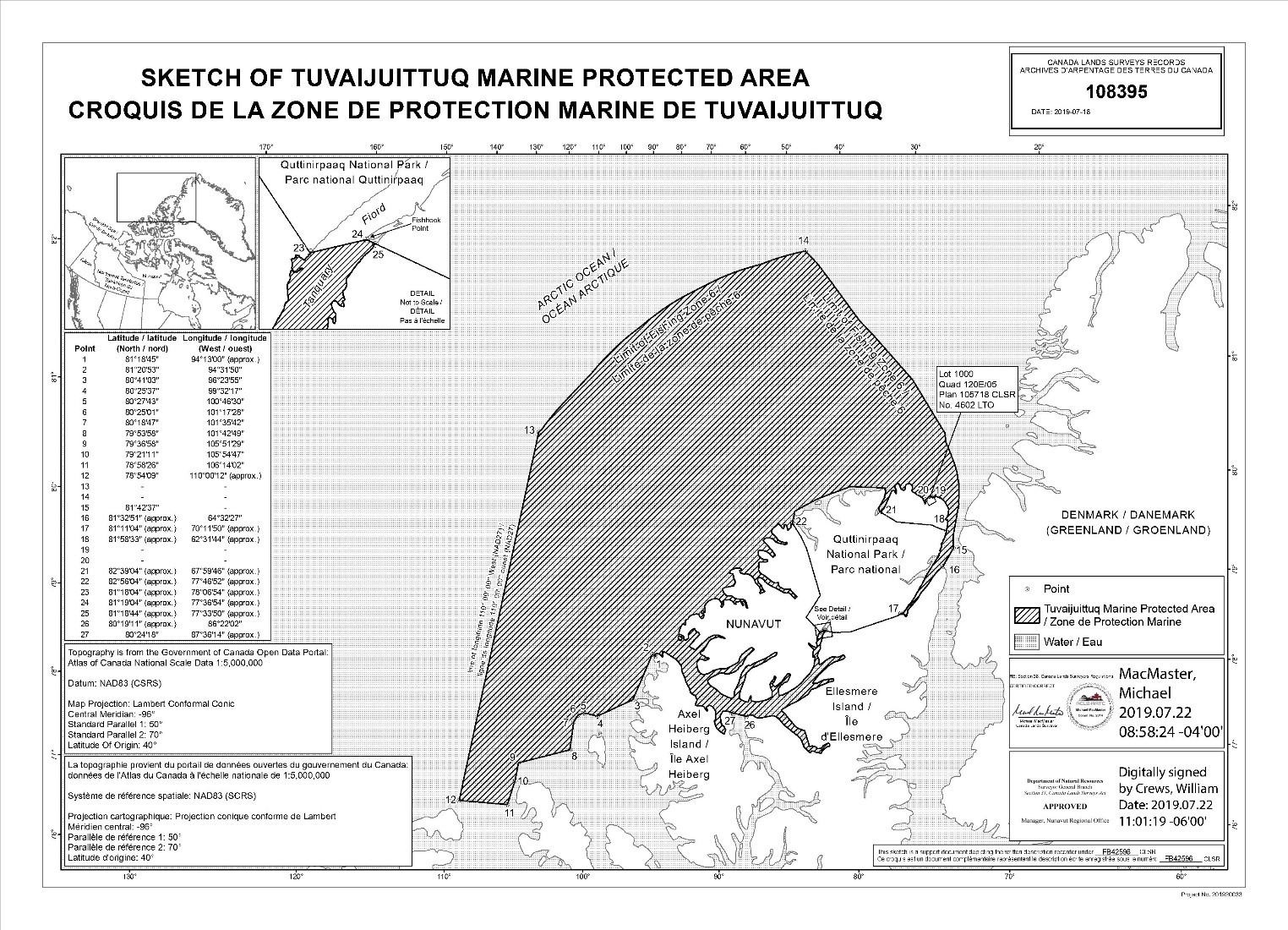
3.3The Tuvaijuittuq Marine Protected Area
The Tuvaijuittuq Marine Protected Area was designated pursuant to the Oceans Act on July 29, 2019. The full text of the regulations may be accessed in the Order No. 2 Designating the Tuvaijuittuq Marine Protected Area.
Coordinates
The Tuvaijuittuq Marine Protected Area encompasses an area of the sea in the Arctic Ocean consisting of the waters off northern Ellesmere Island, as described in plan number FB42596, certified on July 16, 2019 and depicted in plan number CLSR 108395 plans are deposited in the Canada Lands Surveys Records.
The Marine Protected Area consists of the seabed, the subsoil to a depth of five metres and the water column, including the sea ice, each of which is below the low-water line.
Regulatory Requirements for Vessel Operating in the Tuvaijuittuq Marine Protected Area
•See Section 5A - General Regulatory Requirements for all Oceans Act Marine Protected Areas.
Other Requirement for the Tuvaijuittuq Marine Protected Area
oIt is prohibited in the Marine Protected Area to carry out any activity — other than the purposes of (a) national defence activities carried out by the Department of National Defence; and (b) marine scientific research activities — that disturbs, damages, destroys or removes from the Marine Protected Area any unique geological or archeological features or any living marine organism or any part of its habitat, or is likely to do so. Despite the prohibition listed above, the following activities may be carried out in the Marine Protected Area: (a) marine navigation by a foreign national, a foreign ship or a foreign state, or an entity incorporated or formed by or under the laws of a country other than Canada; and (b) the laying, maintenance and repair of cables and pipelines by a foreign state. This Order does not apply with respect to the wildlife harvesting rights of the Inuit in the Nunavut Settlement Area, as provided for in the Agreement Between the Inuit of the Nunavut Settlement Area and Her Majesty the Queen in Right of Canada, as approved, given effect and declared valid by the Nunavut Land Claims Agreement Act.
Requirements for Marine Refuges
General Information on Marine Refuges
Marine refuges are area-based measures that meet the Government of Canada’s criteria of an other effective area-based conservation measure. These measures help protect important species and their habitats, including unique corals and sponges, from the impacts of fishing. These measures are intended to be in place for the long-term, so they will make a lasting contribution to biodiversity. As of 2023, all marine refuges are fisheries area closures established through variation orders (6(1)) and/or licence conditions (22(1)) under the Fishery (General) Regulations under the Fisheries Act (1985).
1 - Marine Refuges in Eastern Canada
The following section provides information on area-based measures that have been recognized as marine refuges in Eastern Canada.
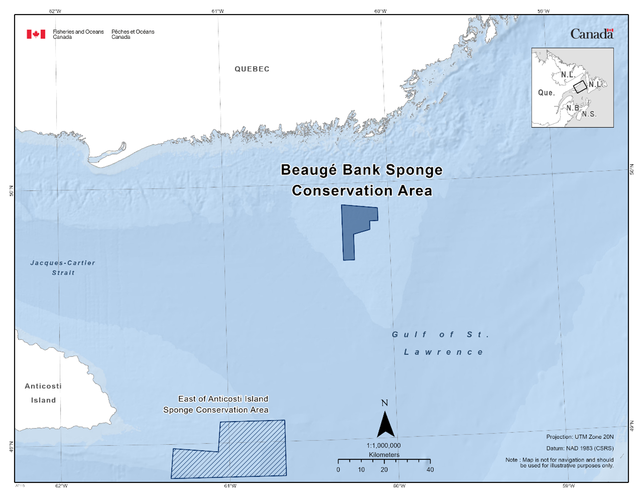
1.1 - Beaugé Bank Sponge Conservation Area
The Beaugé Bank Sponge Conservation Area is found within the Estuary and Gulf of St. Lawrence Bioregion. The fishery area closure was established in 2017 as a variation order. This fishery area closure was granted marine refuge status due to the additional benefits it provides to protect cold-water sponges. The fishery area closure prohibits all fishing that uses bottom-contact gear, such as bottom trawls, dredges, bottom seining, traps, gillnets, and bottom longlines.
Coordinates
The Beaugé Bank Sponge Conservation Area is approximately 215 km2 in size. The geographic boundary of this area is expressed in Latitude and Longitude and these point references are based on the Geodetic System North American Datum 1983 (NAD83). Positions are expressed in degrees, minutes and seconds. The Beaugé Bank Sponge Conservation Area is bounded by a line connecting the points in the order they are listed:
|
Point |
Latitude (North) |
Longitude (West) |
|
1 |
49° 55' 00'' |
60° 17' 00'' |
|
2 |
49° 54' 00'' |
60° 04' 00'' |
|
3 |
49° 51' 00'' |
60° 04' 00'' |
|
4 |
49° 51' 00'' |
60° 07' 00'' |
|
5 |
49° 49' 00'' |
60° 07' 00'' |
|
6 |
49° 48' 00'' |
60° 13' 00'' |
|
7 |
49° 42' 00'' |
60° 13' 00'' |
|
8 |
49° 42' 00'' |
60° 17' 00'' |
|
9 |
49° 55' 00'' |
60° 17' 00'' |
The Beaugé Bank Sponge Conservation Area is shown in the map below:
1.2 - Central Gulf of St. Lawrence Coral Conservation Area
The Central Gulf of St. Lawrence Coral Conservation Area is found within the Estuary and Gulf of St. Lawrence Bioregion. The fishery area closure was established in 2017 as a variation order. This fishery area closure was granted marine refuge status due to the additional benefits it provides to protect cold-water corals. The fishery area closure prohibits all fishing that uses bottom-contact gear, such as bottom trawls, dredges, bottom seining, traps, gillnets, and bottom longlines.
Coordinates
The Central Gulf of St. Lawrence Coral Conservation Area is approximately 1,284 km2 in size. The geographic boundary of this area is expressed in Latitude and Longitude and these point references are based on the Geodetic System North American Datum 1983 (NAD83). Positions are expressed in degrees, minutes and seconds. The Central Gulf of St. Lawrence Coral Conservation Area is bounded by a line connecting the points in the order they are listed:
|
Point |
Latitude (North) |
Longitude (West) |
|
1 |
48° 39' 00'' |
61° 14' 00'' |
|
2 |
48° 31' 00'' |
60° 35' 00'' |
|
3 |
48° 26' 00'' |
60° 35' 00'' |
|
4 |
48° 17' 00'' |
60° 48' 00'' |
|
5 |
48° 18' 00'' |
60° 59' 00'' |
|
6 |
48° 29' 00'' |
61° 16' 00'' |
|
7 |
48° 39' 00'' |
61° 14' 00'' |
The Central Gulf of St. Lawrence Coral Conservation Area is shown in the map below:
Additional Measures
Due to the presence of the endangered North Atlantic Right Whale (Eubalaena glacialis), vessels travelling through the Estuary and Gulf of St. Lawrence should familiarize themselves with the set speed restrictions in specific zones. For more information on the speed restrictions view the Ship Safety Bulletin.
1.3 - East of Anticosti Island Sponge Conservation Area
The East of Anticosti Island Sponge Conservation Area can be found within the Estuary and Gulf of St. Lawrence Bioregion. The fishery area closure was established in 2017 as a variation order. This fishery area closure was granted marine refuge status due to the additional benefits it provides to protect cold-water sponges. The fishery area closure prohibits all bottom fishing activities.
Coordinates
The East of Anticosti Island Sponge Conservation Area is approximately 939 km2 in size. The geographic boundary of this area is expressed in Latitude and Longitude and these point references are based on the Geodetic System North American Datum 1983 (NAD83). Positions are expressed in degrees, minutes and seconds. The East of Anticosti Island Sponge Conservation Area is bounded by a line connecting the points in the order they are listed:
|
Point |
Latitude (North) |
Longitude (West) |
|
1 |
49° 05' 00'' |
61° 03' 00'' |
|
2 |
49° 05' 00'' |
60° 40' 00'' |
|
3 |
48° 52' 00'' |
60° 40' 00'' |
|
4 |
48° 52' 00'' |
61° 21' 00'' |
|
5 |
48° 59' 00'' |
61° 20' 00'' |
|
6 |
48° 58' 00'' |
61° 04' 00'' |
|
7 |
49° 05' 00'' |
61° 03' 00'' |
The East of Anticosti Island Sponge Conservation Area in the map below:
Additional Measures
Due to the presence of the endangered North Atlantic Right Whale (Eubalaena glacialis), vessels travelling through the Estuary and Gulf of St. Lawrence should familiarize themselves with the set speed restrictions in specific zones. For more information on the speed restrictions view the Ship Safety Bulletin.
1.4 - Eastern Gulf of St. Lawrence Coral Conservation Area
The Eastern Gulf of St. Lawrence Coral Conservation Area can be found within the Estuary and Gulf of St. Lawrence Bioregion. The fishery area closure was established in 2017 as a variation order. This fishery area closure was granted marine refuge status due to the additional benefits it provides to protect cold-water corals. The fishery area closure prohibits all fishing that uses bottom-contact gear, such as bottom trawls, dredges, bottom seining, traps, gillnets, and bottom longlines.
Coordinates
The Eastern Gulf of St. Lawrence Coral Conservation Area is approximately 423 km2 in size. The geographic boundary of this area is expressed in Latitude and Longitude and these point references are based on the Geodetic System North American Datum 1983 (NAD83). Positions are expressed in degrees, minutes and seconds. The Eastern Gulf of St. Lawrence Coral Conservation Area is bounded by a line connecting the points in the order they are listed:
|
Point |
Latitude (North) |
Longitude (West) |
|
1 |
47° 51' 00'' |
60° 28' 00'' |
|
2 |
47° 53' 00'' |
60° 16' 00'' |
|
3 |
47° 32' 00'' |
60° 14' 00'' |
|
4 |
47° 31' 00'' |
60° 19' 00'' |
|
5 |
47° 51' 00'' |
60° 28' 00'' |
The Eastern Gulf of St. Lawrence Coral Conservation Area in the map below:
Additional Measures
Due to the presence of the endangered North Atlantic Right Whale (Eubalaena glacialis), vessels travelling through the Estuary and Gulf of St. Lawrence should familiarize themselves with the set speed restrictions in specific zones. For more information on the speed restrictions view the Ship Safety Bulletin.
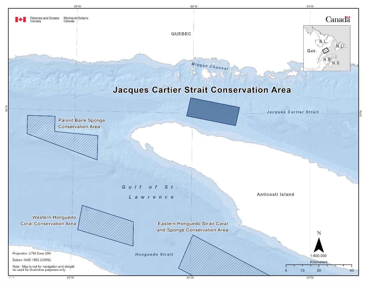
1.5 - Eastern Honguedo Strait Coral and Sponge Conservation Area
The Eastern Honguedo Strait Coral and Sponge Conservation Area can be found within the Estuary and Gulf of St. Lawrence Bioregion. The fishery area closure was established in 2017 as a variation order. This fishery area closure was granted marine refuge status due to the additional benefits it provides to protect cold-water corals and sponges. This fishery area closure prohibits all fishing that uses bottom-contact gear, such as bottom trawls, dredges, bottom seining, traps, gillnets, and bottom longlines.
Coordinates
The Eastern Honguedo Strait Coral and Sponge Conservation Area is approximately 2,338 km2 in size. The geographic boundary of this area is expressed in Latitude and Longitude and these point references are based on the Geodetic System North American Datum 1983 (NAD83). Positions are expressed in degrees, minutes and seconds. The Eastern Honguedo Strait Coral and Sponge Conservation Area is bounded by a line connecting the points in the order they are listed:
|
Point |
Latitude (North) |
Longitude (West) |
|
1 |
49° 20' 00'' |
63° 59' 00'' |
|
2 |
48° 56' 00'' |
62° 49' 00'' |
|
3 |
48° 40' 00'' |
62° 58' 00'' |
|
4 |
48° 57' 00'' |
63° 30' 00'' |
|
5 |
49° 09' 00'' |
64° 06' 00'' |
|
6 |
49° 20' 00'' |
63° 59' 00'' |
The Eastern Honguedo Strait Coral and Sponge Conservation Area in the map below:
Additional Measures
Due to the presence of the endangered North Atlantic Right Whale (Eubalaena glacialis), vessels travelling through the Estuary and Gulf of St. Lawrence should familiarize themselves with the set speed restrictions in specific zones. For more information on the speed restrictions view the Ship Safety Bulletin.
1.6 - Jacques-Cartier Strait Sponge Conservation Area
The Jacques-Cartier Strait Sponge Conservation Area can be found within the Estuary and Gulf of St. Lawrence Bioregion. The fishery area closure was established in 2017 as a variation order. The fishery area closure was granted marine refuge status due to the additional benefits it provides in to protect cold-water sponges. The fishery area closure prohibits all fishing that uses bottom contact gear, such as bottom trawls, dredges, bottom seining, traps, gillnets, and bottom longlines. The area is also home to marine mammals.
Coordinates
The Jacques-Cartier Strait Sponge Conservation Area is approximately 346 km2 in size. The geographic boundary of this area is expressed in Latitude and Longitude and these point references are based on the Geodetic System North American Datum 1983 (NAD83). Positions are expressed in degrees, minutes and seconds. The Jacques-Cartier Strait Sponge Conservation Area is bounded by a line connecting the points in the order they are listed:
|
Point |
Latitude (North) |
Longitude (West) |
|
1 |
50° 05' 00'' |
64° 01' 00'' |
|
2 |
50° 02' 00'' |
63° 36' 00'' |
|
3 |
49° 56' 00'' |
63° 38' 00'' |
|
4 |
49° 59' 00'' |
64° 03' 00'' |
|
5 |
50° 05' 00'' |
64° 01' 00'' |
The Jacques-Cartier Strait Sponge Conservation Area in the map below:
Additional Measures
Due to the presence of the endangered North Atlantic Right Whale (Eubalaena glacialis), vessels travelling through the Estuary and Gulf of St. Lawrence should familiarize themselves with the set speed restrictions in specific zones. For more information on the speed restrictions view the Ship Safety Bulletin.
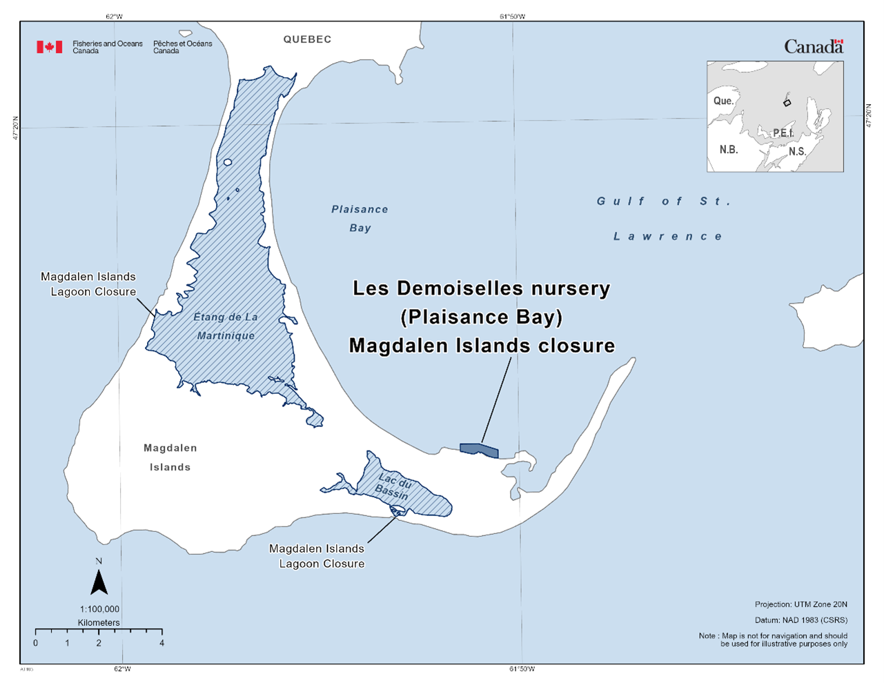
1.7 Les Demoiselles Nursery (Plaisance Bay) Marine Refuge, Magdalen Islands
The Les Demoiselles Nursery (Plaisance Bay) Marine Refuge, Magdalen Islands can be found within the Estuary and Gulf of St. Lawrence Bioregion. The marine refuge includes a fishery area closure implemented by condition of licence. This closure was granted marine refuge status in 2016 because of the additional benefits they offer in protecting juvenile American lobster nursery grounds. This fishery area closure prohibits hydraulic dredge for the Atlantic surf clam and Atlantic razor clam, otter trawl, Danish and Scottish seine for the winter flounder, witch flounder, yellowtail flounder, and American plaice.
Coordinates
The Les Demoiselles (Plaisance Bay) Marine Refuge, Magdalen Islands is approximately 0.3 km2.
|
Point |
Latitude (North) |
Longitude (West) |
|
1 |
47° 14' 13.80'' |
61° 50' 31.60'' |
|
2 |
47° 14' 24.00'' |
61° 50' 31.60'' |
|
3 |
47° 14' 30.50'' |
61° 51' 00.70'' |
|
4 |
47° 14' 30.50'' |
61° 51' 28.30'' |
|
5 |
47° 14' 22.30'' |
61° 51' 28.30'' |
The Les Demoiselles (Plaisance Bay) Magdalen Islands Closure in the map below:
1.8 - Magdalen Islands Lagoons Marine Refuge
The Magdalen Islands Lagoons Marine Refuge can be found within the Estuary and Gulf of St. Lawrence Bioregion. The Magdalen Islands Lagoons Marine Refuge includes six fishery area closures implemented by licence conditions or legislation. These closures were granted marine refuge status in 2017 because of the additional benefits they offer in protecting lobster habitat and preserving herring spawning grounds. These fishery closures prohibit hydraulic dredging for razor clams and Atlantic surf clams, gillnetting and tile fishing for winter flounder, gillnetting for Atlantic herring, pelagic trawling and Danish and Scottish seines for yellowtail flounder and winter flounder, and trap fishing for American lobster.
Coordinates
The Magdalen Islands Lagoons Marine Refuge is approximately 136
km2 in size. The boundary of the closure is defined as
the lagoons of the Magdalen Islands in Lobster Fishing Area 22 or
the interior bodies of water of the Magdalen Islands.
The Magdalen Islands Lagoons Marine Refuge in the map below:
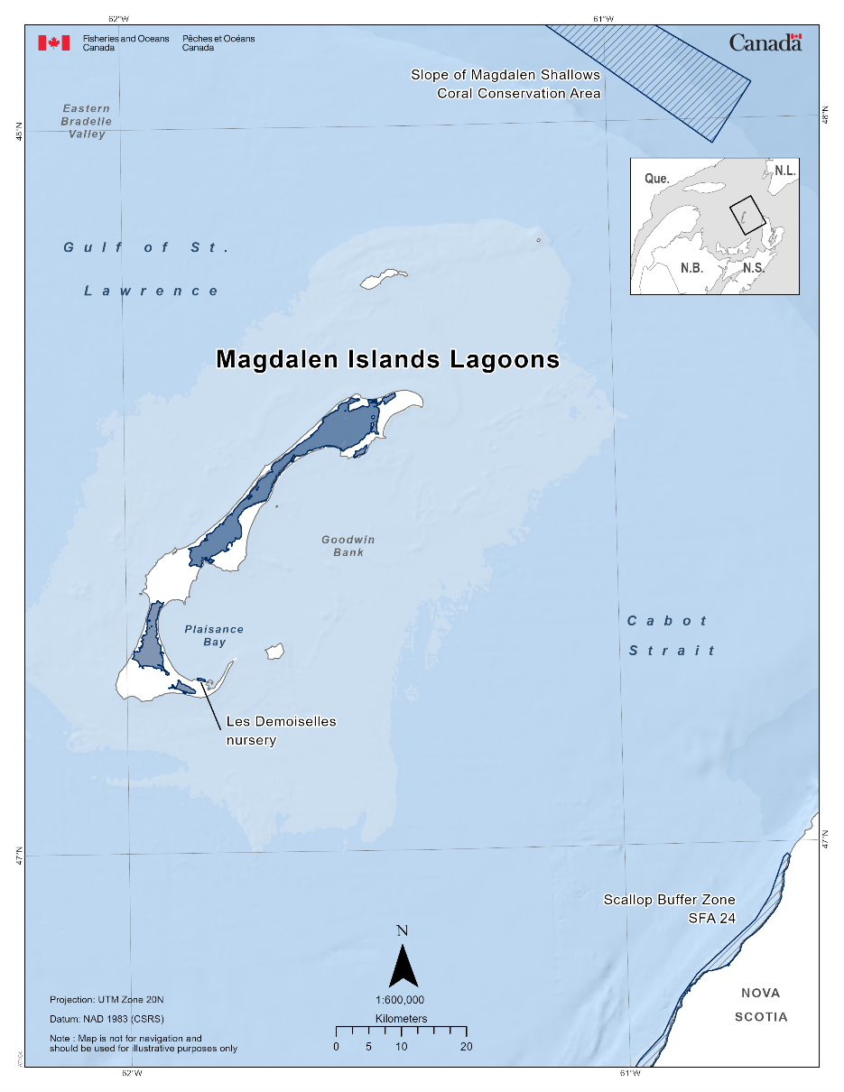
1.9 - Miramichi Bay Closure
The Miramichi Bay Closure can be found within the Estuary and Gulf of St. Lawrence Bioregion. The fishery area closure was established in 1985 under the Fisheries Act. This fishery area closure was granted marine refuge status due to the additional benefits it provides to protect adult Atlantic salmon and an important migration corridor. The fishery area closure prohibits the use of gillnets for all commercial groundfish fisheries.
Coordinates
The Miramichi Bay Closure is approximately 1,468 km2 in size. The geographic boundary of this area is expressed in Latitude and Longitude and these point references are based on the Geodetic System North American Datum 1983 (NAD83). Positions are expressed in degrees, minutes and seconds. The waters adjacent to the coast of New Brunswick enclosed by the coastline, excluding rivers and brooks (ex.: Miramichi River, Napan River, Black River, Eel River, Tabusintac River etc.), and straight lines joining the following points in the order in which they are listed:
|
Point |
Latitude (North) |
Longitude (West) |
|
1 |
47° 26′ 00.0” |
64° 53′ 12.0″ |
|
2 |
47° 04′ 24.0″ |
64° 21′ 45.0″ |
|
3 |
47° 00′ 48.0″ |
64° 49′ 40.0″ |
The Miramichi Bay Closure in the map below:
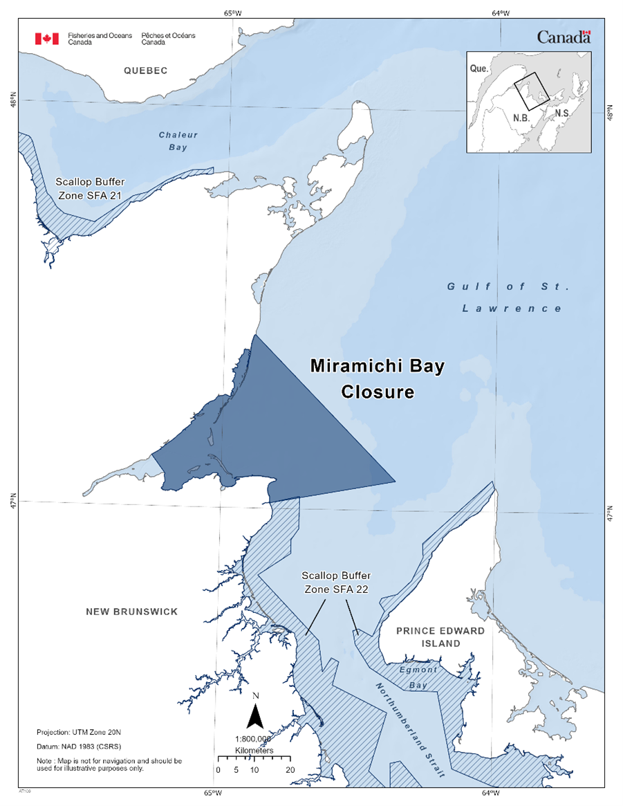
Additional Measures
Due to the presence of the endangered North Atlantic Right Whale (Eubalaena glacialis), vessels travelling through the Estuary and Gulf of St. Lawrence should familiarize themselves with the set speed restrictions in specific zones. For more information on the speed restrictions view the Ship Safety Bulletin.
1.10 - North of Bennett Bank Coral Conservation Area
The North of Bennett Bank Coral Conservation Area can be found within the Estuary and Gulf of St. Lawrence Bioregion. The fishery area closure was established in 2017 as a variation order. This fishery area closure was granted marine refuge status due to the additional benefits it provides to protect cold-water corals. The fishery area closure prohibits all fishing that uses bottom-contact gear, such as bottom trawls, dredges, bottom seining, traps, gillnets, and bottom longlines.
Coordinates
The North of Bennett Bank Coral Conservation Area is approximately 821 km2 in size. The geographic boundary of this area is expressed in Latitude and Longitude and these point references are based on the Geodetic System North American Datum 1983 (NAD83). Positions are expressed in degrees, minutes and seconds. The North of Bennett Bank Coral Conservation Area is bounded by a line connecting the points in the order they are listed:
|
Point |
Latitude (North) |
Longitude (West) |
|
1 |
48° 45' 00'' |
62° 40' 00'' |
|
2 |
48° 37' 00'' |
62° 18' 00'' |
|
3 |
48° 25' 00'' |
62° 20' 00'' |
|
4 |
48° 26' 00'' |
62° 43' 00'' |
|
5 |
48° 45' 00'' |
62° 40' 00'' |
The North of Bennett Bank Coral Conservation Area in the map below:
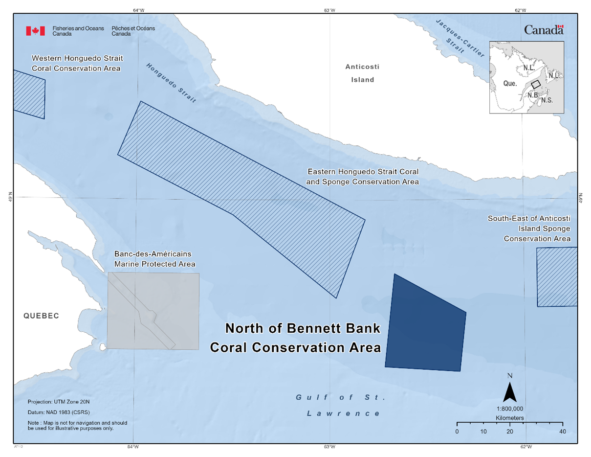
Additional Measures
Due to the presence of the endangered North Atlantic Right Whale (Eubalaena glacialis), vessels travelling through the Estuary and Gulf of St. Lawrence should familiarize themselves with the set speed restrictions in specific zones. For more information on the speed restrictions view the Ship Safety Bulletin.
1.11 - Parent Bank Sponge Conservation Area
The Parent Bank Sponge Conservation Area can be found within the Estuary and Gulf of St. Lawrence Bioregion. The fishery area closure was established in 2017 as a variation order. This fishery area closure was granted marine refuge status due to the additional benefits it provides to protect cold-water sponges. The fishery area closure prohibits all fishing that uses bottom-contact gear, such as bottom trawls, dredges, bottom seining, traps, gillnets, and bottom longlines.
Coordinates
The Parent Bank Sponge Conservation Area is approximately 530 km2 in size. The geographic boundary of this area is expressed in Latitude and Longitude and these point references are based on the Geodetic System North American Datum 1983 (NAD83). Positions are expressed in degrees, minutes and seconds. The Parent Bank Sponge Conservation Area is bounded by a line connecting the points in the order they are listed:
|
Point |
Latitude (North) |
Longitude (West) |
|
1 |
49° 58' 00'' |
65° 24' 00'' |
|
2 |
49° 58' 00'' |
65° 10' 00'' |
|
3 |
49° 53' 00'' |
65° 10' 00'' |
|
4 |
49° 52' 00'' |
64° 48' 00'' |
|
5 |
49° 44' 00'' |
64° 48' 00'' |
|
6 |
49° 52' 00'' |
65° 24' 00'' |
|
7 |
49° 58' 00'' |
65° 24' 00'' |
The Parent Bank Sponge Conservation Area in the map below:
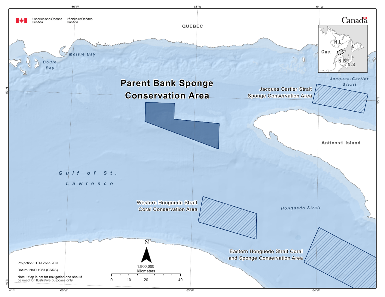
Additional Measures
Due to the presence of the endangered North Atlantic Right Whale (Eubalaena glacialis), vessels travelling through the Estuary and Gulf of St. Lawrence should familiarize themselves with the set speed restrictions in specific zones. For more information on the speed restrictions view the Ship Safety Bulletin.
1.12 - Scallop Buffer Zones (SFA 21, 22, 24)
The Scallop Buffer Zones are located within the Estuary and Gulf of St. Lawrence Bioregion and is within three Scallop Fishing Areas (SFA): SFA 21, SFA 22, and SFA 24. These fishing area closures are currently established via conditions of licence. The fishery area closure within SFA 21 was initially established in 1999 as a variation order, and has since increased in 2013 and again in 2015. The fishery area closure for SFA 22 was established in 2005 as a variation order and the closure for SFA 24 was initially established in 1996 also as a variation order. In 1999 and 2006 additional buffers were added and the zone increased. These portions of the scallop fishing area were granted marine refuge status due to the additional benefits it provides to protect juvenile lobster and its habitat. The fishery area closure prohibits scallop dragging.
Coordinates
In total, the Scallop Buffer Zones are approximately 5,425 km2 in size and are composed of three separate zones with the coordinates outlined for each below. The geographic boundary of this area is expressed in Latitude and Longitude and these point references are based on the Geodetic System North American Datum 1983 (NAD83). Positions are expressed in degrees, minutes and seconds. All Scallop Buffer Zones are bounded by a line connecting the points in the order they are listed.
SFA 21
|
Point |
Latitude (North) |
Longitude (West) |
|
1 |
48° 03' 23.66" |
66° 21' 28.30" |
|
2 |
48° 01' 59.47" |
66° 15' 21.45" |
|
3 |
48° 02' 23.08" |
66° 11' 35.94" |
|
4 |
48° 01' 47.66" |
66° 07' 55.34" |
|
5 |
48° 00' 37.47" |
66° 04' 50.03" |
|
6 |
47° 58' 50.55" |
66° 02' 46.49" |
|
7 |
47° 58' 04.63" |
66° 01' 11.38" |
|
8 |
47° 57' 15.43" |
65° 57' 06.26" |
|
9 |
47° 54' 41.27" |
65° 44' 42.08" |
|
10 |
47° 54' 26.81" |
65° 44' 18.05" |
|
11 |
47° 53' 52.87" |
65° 43' 50.28" |
|
12 |
47° 46' 14.86" |
65° 40' 14.42" |
|
13 |
47° 45' 43.37" |
65° 39' 23.43" |
|
14 |
47° 45' 03.35" |
65° 38' 45.20" |
|
15 |
47° 44' 14.81" |
65° 38' 00.09" |
|
16 |
47° 43' 18.76" |
65° 36' 15.89" |
|
17 |
47° 42' 11.50" |
65° 29' 29.89" |
|
18 |
47° 46' 15.64" |
65° 21' 05.27" |
|
19 |
47° 46' 51.71" |
65° 17' 59.21" |
|
20 |
47° 48' 45.05" |
65° 13' 41.81" |
|
21 |
47° 49' 53.71" |
65° 10' 02.63" |
|
22 |
47° 50' 22.88" |
65° 08' 07.94" |
|
23 |
47° 50' 31.46" |
65° 04' 51.70" |
|
24 |
47° 50' 52.05" |
65° 03' 30.14" |
|
25 |
47° 50' 52.00" |
65° 03' 27.70" |
|
26 |
47° 49' 54.16" |
65° 03' 27.61" |
The SFA 22 is divided into two zones, one along the coast of New Brunswick and the other along the coast of Prince Edward Island.
New Brunswick Coastal Buffer Zone
|
Point |
Latitude (North) |
Longitude (West) |
|
1 |
47° 00' 48.2" |
64° 49' 37.7" |
|
2 |
47° 01' 54.7" |
64° 42' 42.7" |
|
3 |
46° 57' 05.2" |
64° 42' 42.7" |
|
4 |
46° 55' 26.2" |
64° 44' 21.7" |
|
5 |
46° 53' 20.2" |
64° 44' 21.7" |
|
6 |
46° 50' 00.2" |
64° 51' 27.7" |
|
7 |
46° 40' 23.2" |
64° 37' 52.7" |
|
8 |
46° 35' 43.3" |
64° 36' 54.7" |
|
9 |
46° 37' 50.3" |
64° 35' 02.7" |
|
10 |
46° 37' 15.3" |
64° 33' 25.7" |
|
11 |
46° 33' 46.3" |
64° 34' 43.7" |
|
12 |
46° 29' 45.3" |
64° 22' 48.7" |
|
13 |
46° 20' 59.3" |
64° 26' 29.7" |
|
14 |
46° 17' 51.3" |
64° 21' 43.7" |
|
15 |
46° 22' 12.3" |
64° 21' 55.7" |
|
16 |
46° 22' 34.3" |
64° 19' 42.7" |
|
17 |
46° 14' 50.2" |
64° 10' 07.7" |
|
18 |
46° 12' 27.2" |
63° 49' 09.7" |
|
19 |
46° 03' 33.2" |
63° 36' 55.7" |
|
20 |
45° 54' 47.5" |
63° 40' 19.2" |
|
21 |
45° 51' 45.3" |
63° 42' 39.7" |
Prince Edward Island Coastal Buffer Zone
|
Point |
Latitude (North) |
Longitude (West) |
|
1 |
47° 03' 15.2" |
64° 59' 57.7" |
|
2 |
47° 04' 41.2" |
64° 00' 33.7" |
|
3 |
46° 55' 09.3" |
64° 15' 37.7" |
|
4 |
46° 53' 06.3" |
64° 15' 26.7" |
|
5 |
46° 49' 34.3" |
64° 17' 53.7" |
|
6 |
46° 47' 30.3" |
64° 20' 59.7" |
|
7 |
46° 46' 53.3" |
64° 24' 19.7" |
|
8 |
46° 46' 11.3" |
64° 24' 49.7" |
|
9 |
46° 45' 00.3" |
64° 23' 39.7" |
|
10 |
46° 41' 08.3" |
64° 26' 13.8" |
|
11 |
46° 42' 14.3" |
64° 29' 15.7" |
|
12 |
46° 41' 57.3" |
64° 30' 29.7" |
|
13 |
46° 39' 52.3" |
64° 29' 53.8" |
|
14 |
46° 36' 29.3" |
64° 26' 42.7" |
|
15 |
46° 33' 08.3" |
64° 19' 04.7" |
|
16 |
46° 33' 03.3" |
64° 11' 56.7" |
|
17 |
46° 21' 30.3" |
64° 08' 32.7" |
|
18 |
46° 19' 02.2" |
63° 59' 50.7" |
|
19 |
46° 17' 35.2" |
63° 48' 08.7" |
|
20 |
46° 07' 54.0" |
63° 30' 12.8" |
|
21 |
46° 10' 35.2" |
63° 28' 00.7" |
|
22 |
46° 12' 58.2" |
63° 29' 23.7" |
SFA 24
Those waters adjacent to the Province of Nova Scotia within one (1) nautical mile from the nearest point of land in the counties of Cumberland, Colchester, Pictou, including Pictou Island in the Northumberland Strait and Antigonish. Those waters adjacent to the western coast of Cape Breton, Nova Scotia, within one (1) nautical mile from the nearest point of land, from the Canso Causeway, northward including Henry Island and Port Hood Island, to the Mabou Harbour entrance range lights. Those waters adjacent to the Province of Prince Edward Island inside rhumb lines (similar to straight lines plotted on a nautical chart) joining the following points in the order they are listed:
|
Point |
Latitude (North) |
Longitude (West) |
|
1 |
46° 22' 17.0" |
62° 06' 55.0" |
|
2 |
46° 20' 39.0" |
62° 06' 54.0" |
|
3 |
46° 19' 03.0" |
62° 15' 18.0" |
|
4 |
46° 04' 39.0" |
62° 15' 38.0" |
|
5 |
46° 07' 06.0" |
61° 55' 09.0" |
|
6 |
46° 04' 42.0" |
61° 53' 06.0" |
|
7 |
45° 59' 28.0" |
62° 25' 31.0" |
|
8 |
45° 56' 47.0" |
62° 30' 38.0" |
|
9 |
45° 56' 20.0" |
62° 50' 36.0" |
|
10 |
46° 02' 25.0" |
63° 04' 17.0" |
|
11 |
46° 03' 00.0" |
63° 02' 25.0" |
Those waters adjacent to the western coast of Cape Breton, Nova Scotia, inside rhumb lines (similar to straight lines plotted on a nautical chart) joining the following points in the order they are listed:
|
Point |
Latitude (North) |
Longitude (West) |
|
1 |
46° 05' 09.2" |
61° 27' 55.2" |
|
2 |
46° 05' 54.0" |
61° 31' 24.0" |
|
3 |
46° 07' 42.0" |
61° 29' 15.0" |
|
4 |
46° 08' 34.0" |
61° 28' 29.0" |
|
5 |
46° 09' 44.0" |
61° 28' 02.0" |
|
6 |
46° 10' 56.0" |
61° 26' 18.0" |
|
7 |
46° 11' 57.0" |
61° 25' 24.0" |
|
8 |
46° 15' 42.0" |
61° 19' 03.0" |
|
9 |
46° 18' 37.0" |
61° 16' 35.0" |
|
10 |
46° 19' 43.0" |
61° 15' 44.0" |
|
11 |
46° 20' 17.0" |
61° 15' 49.0" |
|
12 |
46° 20' 55.0" |
61° 16' 33.0" |
|
13 |
46° 21' 43.0" |
61° 16' 25.0" |
|
14 |
46° 22' 59.0" |
61° 14' 41.0" |
|
15 |
46° 24' 03.0" |
61° 11' 10.0" |
|
16 |
46° 28' 44.0" |
61° 07' 23.0" |
|
17 |
46° 30' 44.0" |
61° 05' 47.0" |
|
18 |
46° 31' 55.0" |
61° 05' 06.0" |
|
19 |
46° 33' 35.0" |
61° 04' 22.0" |
|
20 |
46° 35' 45.0" |
61° 04' 06.0" |
|
21 |
46° 36' 38.0" |
61° 03' 41.0" |
|
22 |
46° 36' 59.0" |
61° 03' 52.0" |
|
23 |
46° 37' 46.0" |
61° 03' 03.0" |
|
24 |
46° 39' 05.0" |
61° 02' 10.0" |
|
25 |
46° 40' 19.0" |
61° 00' 30.0" |
|
26 |
46° 42' 11.0" |
60° 58' 50.0" |
|
27 |
46° 44' 14.0" |
60° 55' 57.0" |
|
28 |
46° 47' 15.0" |
60° 53' 46.0" |
|
29 |
46° 49' 12.0" |
60° 51' 38.0" |
|
30 |
46° 53' 33.0" |
60° 44' 27.0" |
|
31 |
46° 55' 34.0" |
60° 42' 32.0" |
|
32 |
46° 58' 42.0" |
60° 40' 47.0" |
|
33 |
46° 58' 59.2" |
60° 40' 20.8" |
|
34 |
46° 58' 42.2" |
60° 39' 57.2" |
The Scallop Buffer Zones in the maps below:
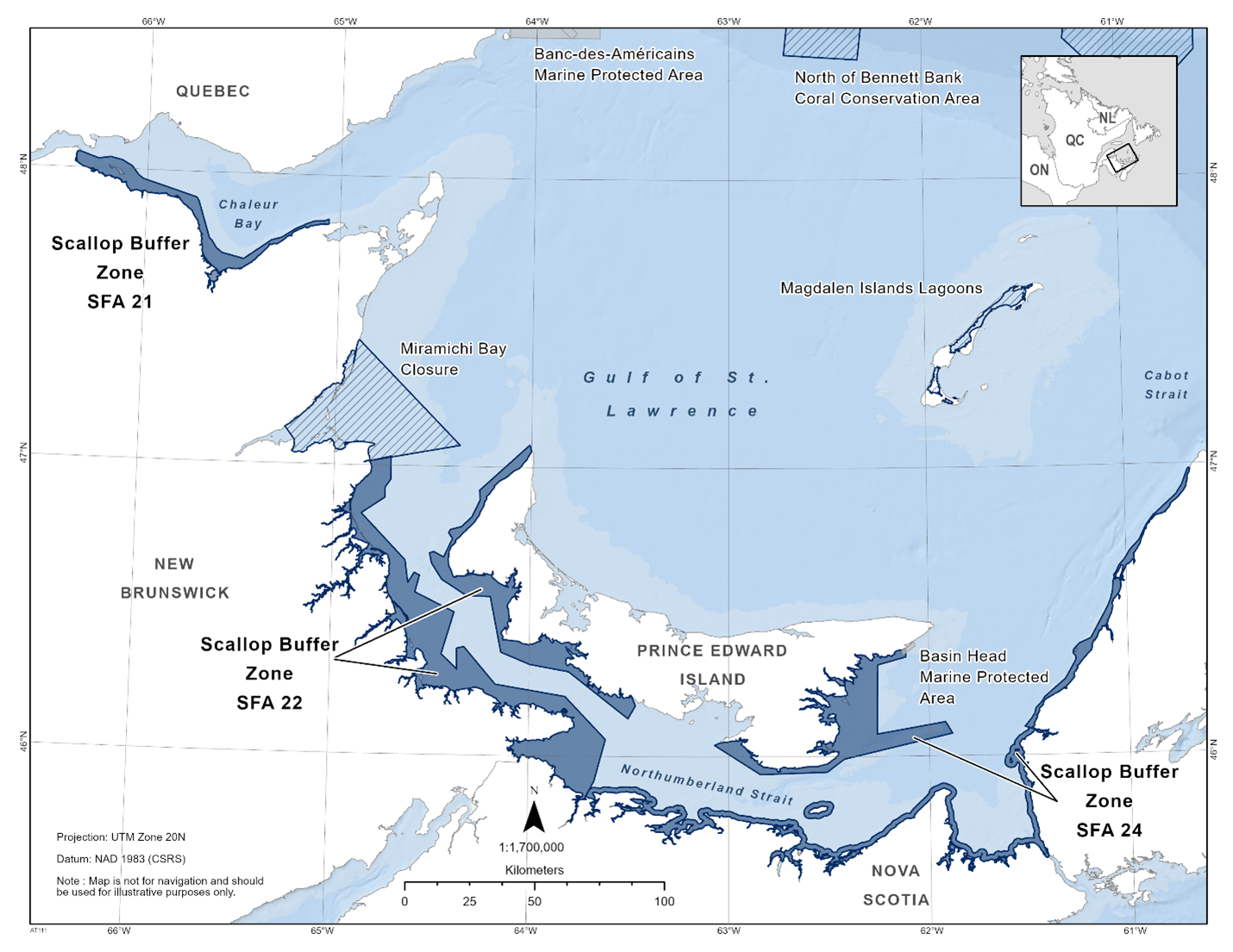
Additional Measures
Due to the presence of the endangered North Atlantic Right Whale (Eubalaena glacialis), vessels travelling through the Estuary and Gulf of St. Lawrence should familiarize themselves with the set speed restrictions in specific zones. For more information on the speed restrictions view the Ship Safety Bulletin.
1.13 - Slope of Magdalen Shallows Coral Conservation Area
The Slope of Magdalen Shallows Coral Conservation Area can be found within the Estuary and Gulf of St. Lawrence Bioregion. The fishery area closure was established in 2017 as a variation order. This fishery area closure was granted marine refuge status due to the additional benefits it provides to protect cold-water corals. The fishery area closure prohibits all fishing that uses bottom-contact gear, such as bottom trawls, dredges, bottom seining, traps, gillnets, and bottom longlines.
Coordinates
The Slope of Magdalen Shallows Coral Conservation Area is approximately 335 km2 in size. The geographic boundary of this area is expressed in Latitude and Longitude and these point references are based on the Geodetic System North American Datum 1983 (NAD83). Positions are expressed in degrees, minutes and seconds. The Slope of Magdalen Shallows Coral Conservation Area is bounded by a line connecting the points in the order they are listed:
|
|
Latitude (North) |
Longitude (West) |
|
1 |
48° 13' 00'' |
61° 06' 00'' |
|
2 |
48° 03' 00'' |
60° 42' 00'' |
|
3 |
47° 58' 00'' |
60° 47' 00'' |
|
4 |
48° 09' 00'' |
61° 09' 00'' |
|
5 |
48° 13' 00'' |
61° 06' 00'' |
The Slope of Magdalen Shallows Coral Conservation Area in the map below:
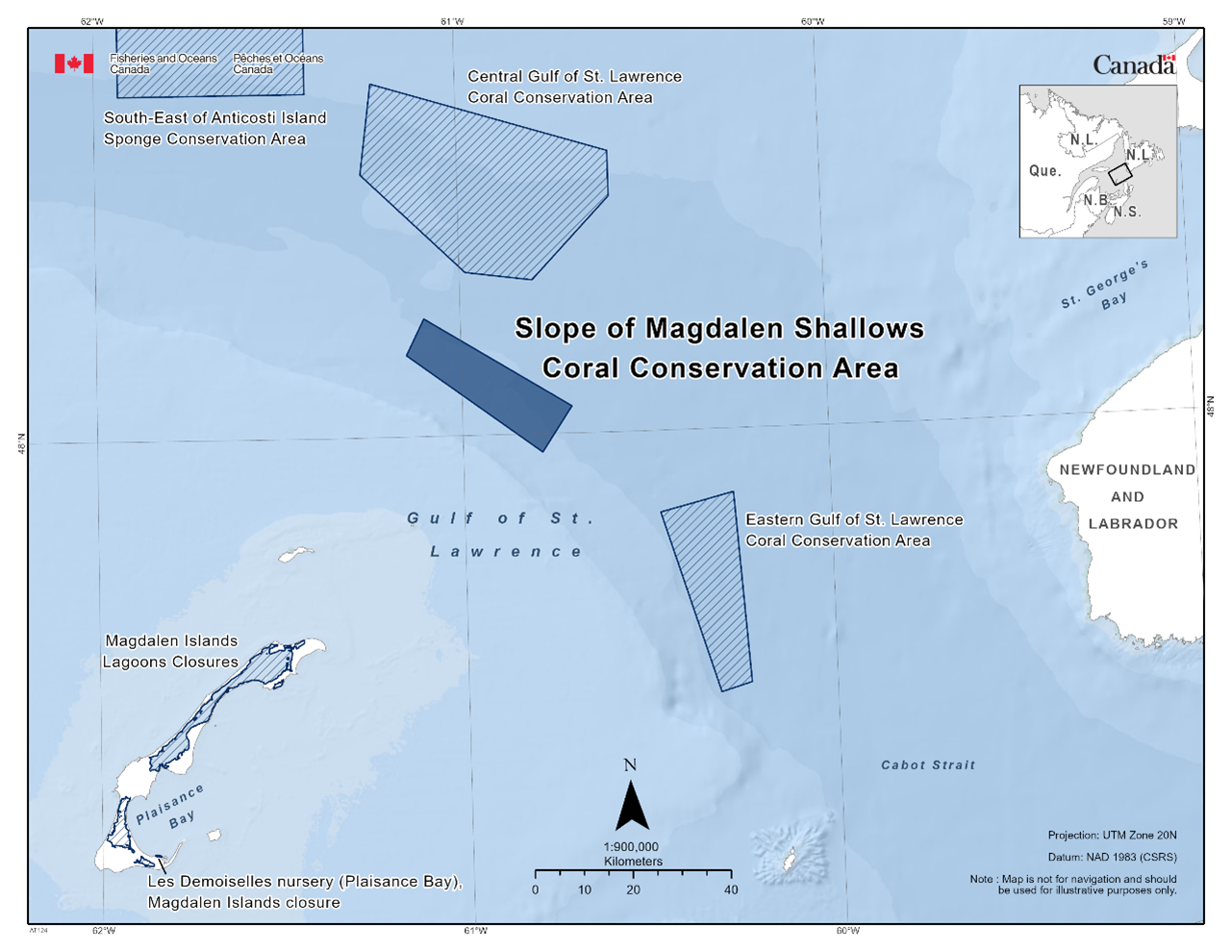
Additional Measures
Due to the presence of the endangered North Atlantic Right Whale (Eubalaena glacialis), vessels travelling through the Estuary and Gulf of St. Lawrence should familiarize themselves with the set speed restrictions in specific zones. For more information on the speed restrictions view the Ship Safety Bulletin.
1.14 - South-East of Anticosti Island Sponge Conservation Area
The South-East of Anticosti Island Sponge Conservation Area can be found within the Estuary and Gulf of St. Lawrence Bioregion. The fishery area closure was established in 2017 as a variation order. This fishery area closure was granted marine refuge status due to the additional benefits it provides to protect cold-water sponges. The fishery area closure prohibits all fishing that uses bottom-contact gear, such as bottom trawls, dredges, bottom seining, traps, gillnets, and bottom longlines.
Coordinates
The South-East of Anticosti Island Sponge Conservation Area is approximately 845 km2 in size. The geographic boundary of this area is expressed in Latitude and Longitude and these point references are based on the Geodetic System North American Datum 1983 (NAD83). Positions are expressed in degrees, minutes and seconds. The South-East of Anticosti Island Sponge Conservation Area is bounded by a line connecting the points in the order they are listed:
|
Point |
Latitude (North) |
Longitude (West) |
|
1 |
48° 50' 00'' |
61° 56' 00'' |
|
2 |
48° 50' 00'' |
61° 25' 00'' |
|
3 |
48° 38' 00'' |
61° 25' 00'' |
|
4 |
48° 38' 00'' |
61° 56' 00'' |
|
5 |
48° 50' 00'' |
61° 56' 00'' |
The South-East of Anticosti Island Sponge Conservation Area in the map below:
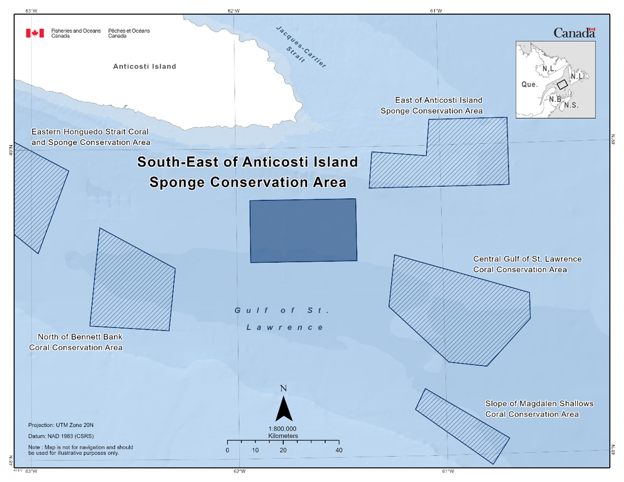
Additional Measures
Due to the presence of the endangered North Atlantic Right Whale (Eubalaena glacialis), vessels travelling through the Estuary and Gulf of St. Lawrence should familiarize themselves with the set speed restrictions in specific zones. For more information on the speed restrictions view the Ship Safety Bulletin.
1.15 - Western Honguedo Strait Coral Conservation Area
The Western Honguedo Strait Coral Conservation Area can be found within the Estuary and Gulf of St. Lawrence Bioregion. The fishery area closure was established in 2017 as a variation order. This fishery area closure was granted marine refuge status due to the additional benefits it provides to protect cold-water corals. The fishery area closure prohibits all fishing that uses bottom-contact gear, such as bottom trawls, dredges, bottom seining, traps, gillnets, and bottom longlines.
Coordinates
The Western Honguedo Strait Coral Conservation Area is approximately 496 km2 in size. The geographic boundary of this area is expressed in Latitude and Longitude and these point references are based on the Geodetic System North American Datum 1983 (NAD83). Positions are expressed in degrees, minutes and seconds. The Western Honguedo Strait Coral Conservation Area is bounded by a line connecting the points in the order they are listed:
|
Point |
Latitude (North) |
Longitude (West) |
|
1 |
49° 29' 00'' |
64° 55' 00'' |
|
2 |
49° 24' 00'' |
64° 29' 00'' |
|
3 |
49° 16' 00'' |
64° 29' 00'' |
|
4 |
49° 21' 00'' |
64° 57' 00'' |
|
5 |
49° 29' 00'' |
64° 55' 00'' |
The Western Honguedo Strait Coral Conservation Area in the map below:
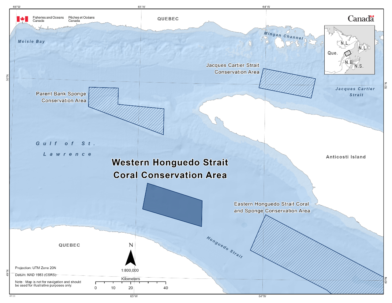
Additional Measures
Due to the presence of the endangered North Atlantic Right Whale (Eubalaena glacialis), vessels travelling through the Estuary and Gulf of St. Lawrence should familiarize themselves with the set speed restrictions in specific zones. For more information on the speed restrictions view the Ship Safety Bulletin.
1.16 - Corsair and Georges Canyons Marine Refuge
The Corsair and Georges Canyons Marine Refuge is found within the Scotian Shelf Bioregion. The fishery area closure was established in 2016 as a condition of licence. This fishery area closure was granted marine refuge status due to the additional benefits it provides to protect cold-water corals. The fishery area closure prohibits all commercial bottom-contact fishing gear.
Coordinates
The Corsair and Georges Canyons Marine Refuge is approximately 8, 797 km2 in size. The geographic boundary of this area is expressed in Latitude and Longitude and these point references are based on the Geodetic System North American Datum 1983 (NAD83). Positions are expressed in degrees, minutes and seconds. This site is located adjacent to the United States border on the outer edge of Georges Bank (of southern Nova Scotia) and extends to the outer limit of the Canadian Exclusive Economic Zone. The Corsair and Georges Canyons Marine Refuge is bounded by a line connecting the points in the order they are listed:
|
Point |
Latitude (North) |
Longitude (West) |
|
1 |
41° 09' 59.366" |
66° 17' 41.547" |
|
2 |
41° 11' 45.000" |
66° 16' 45.000" |
|
3 |
41° 12' 15.000" |
66° 16' 15.000" |
|
4 |
41° 12' 15.000" |
66° 15' 00.000" |
|
5 |
41° 12' 45.000" |
66° 14' 15.000" |
|
6 |
41° 14' 00.000" |
66° 14' 30.000" |
|
7 |
41° 15' 00.000" |
66° 14' 30.000" |
|
8 |
41° 15' 30.000" |
66° 15' 00.000" |
|
9 |
41° 15' 30.000" |
66° 15' 30.000" |
|
10 |
41° 16' 00.000" |
66° 15' 30.000" |
|
11 |
41° 16' 45.000" |
66° 16' 00.000" |
|
12 |
41° 16' 45.000" |
66° 14' 00.000" |
|
13 |
41° 16' 45.000" |
66° 13' 30.000" |
|
14 |
41° 16' 30.000" |
66° 12' 30.000" |
|
15 |
41° 17' 30.000" |
66° 11' 15.000" |
|
16 |
41° 17' 45.000" |
66° 10' 15.000" |
|
17 |
41° 18' 07.500" |
66° 10' 00.000" |
|
18 |
41° 18' 30.000" |
66° 09' 45.000" |
|
19 |
41° 18' 45.000" |
66° 10' 00.000" |
|
20 |
41° 19' 15.000" |
66° 10' 00.000" |
|
21 |
41° 19' 45.000" |
66° 10' 15.000" |
|
22 |
41° 20' 00.000" |
66° 10' 15.000" |
|
23 |
41° 20' 30.000" |
66° 10' 45.000" |
|
24 |
41° 20' 45.000" |
66° 10' 30.000" |
|
25 |
41° 21' 15.000" |
66° 10' 45.000" |
|
26 |
41° 21' 30.000" |
66° 10' 45.000" |
|
27 |
41° 21' 45.000" |
66° 11' 00.000" |
|
28 |
41° 22' 30.000" |
66° 11' 00.000" |
|
29 |
41° 23' 15.000" |
66° 11' 45.000" |
|
30 |
41° 23' 30.000" |
66° 12' 30.000" |
|
31 |
41° 24' 00.000" |
66° 13' 30.000" |
|
32 |
41° 24' 30.000" |
66° 13' 30.000" |
|
33 |
41° 24' 30.000" |
66° 12' 30.000" |
|
34 |
41° 24' 15.000" |
66° 12' 00.000" |
|
35 |
41° 24' 15.000" |
66° 11' 30.000" |
|
36 |
41° 24' 00.000" |
66° 11' 00.000" |
|
37 |
41° 23' 15.000" |
66° 10' 15.000" |
|
38 |
41° 22' 30.000" |
66° 09' 00.000" |
|
39 |
41° 22' 00.000" |
66° 08' 45.000" |
|
40 |
41° 22' 00.000" |
66° 08' 15.000" |
|
41 |
41° 21' 30.000" |
66° 08' 15.000" |
|
42 |
41° 21' 30.000" |
66° 07' 45.000" |
|
43 |
41° 21' 00.000" |
66° 07' 45.000" |
|
44 |
41° 20' 45.000" |
66° 07' 15.000" |
|
45 |
41° 21' 00.000" |
66° 06' 15.000" |
|
46 |
41° 21' 37.500" |
66° 05' 15.000" |
|
47 |
41° 21' 15.000" |
66° 04' 00.000" |
|
48 |
40° 11' 09.213" |
64° 22' 02.502" |
|
49 |
40° 03' 01.741" |
65° 22' 00.138" |
The Corsair and Georges Canyons Marine Refuge is shown in the map below:
1.17 - Eastern Canyons Marine Refuge
The Eastern Canyons Marine Refuge can be found within the Scotian Shelf Bioregion. The fishery area closure was established in 2022 through variation orders. The final marine refuge was established in licence conditions in June 2022 and encompassed the pre-existing Lophelia Coral Conservation Area, which had been in place since 2004. This fishery area closure was granted marine refuge status due to the additional benefits it provides to protect cold-water corals and the Lophelia pertusa (now known as Desmophyllum pertusum) coral reef. The fishery area closure prohibits all commercial bottom-contact fishing gear.
Coordinates
The Eastern Canyons Marine Refuge is approximately 43, 976 km2 in size with a limited fisheries zone of 76.4 km2 which permits groundfish longline fishing with an at-sea observer while remaining closed to all other bottom-contact fisheries. The geographic boundary of this area is expressed in Latitude and Longitude and these point references are based on the Geodetic System North American Datum 1983 (NAD83). Positions are expressed in degrees, minutes and seconds. The Eastern Canyons Marine Refuge is bounded by a line connecting the points in the order they are listed:
|
Point |
Latitude (North) |
Longitude (West) |
|
1 |
43° 54' 51.339" |
58° 44' 20.541" |
|
2 |
43° 56' 30.000" |
58° 40' 00.000" |
|
3 |
43° 57' 00.000" |
58° 34' 30.000" |
|
4 |
44° 00' 00.000" |
58° 28' 00.000" |
|
5 |
44° 02' 00.000" |
58° 26' 00.000" |
|
6 |
44° 06' 00.000" |
58° 25' 00.000" |
|
7 |
44° 08' 00.000" |
58° 25' 00.000" |
|
8 |
44° 13' 00.000" |
58° 29' 00.000" |
|
9 |
44° 14' 00.000" |
58° 28' 00.000" |
|
10 |
44° 12' 00.000" |
58° 25' 00.000" |
|
11 |
44° 12' 00.000" |
58° 23' 00.000" |
|
12 |
44° 07' 00.000" |
58° 20' 00.000" |
|
13 |
44° 07' 00.000" |
58° 18' 00.000" |
|
14 |
44° 10' 00.000" |
58° 17' 00.000" |
|
15 |
44° 10' 00.000" |
58° 14' 00.000" |
|
16 |
44° 08' 00.000" |
58° 12' 00.000" |
|
17 |
44° 10' 00.000" |
58° 05' 00.000" |
|
18 |
44° 18' 00.000" |
57° 59' 30.000" |
|
19 |
44° 18' 00.000" |
57° 55' 00.000" |
|
20 |
44° 15' 00.000" |
57° 54' 00.000" |
|
21 |
44° 13' 30.000" |
57° 52' 00.000" |
|
22 |
44° 13' 30.000" |
57° 49' 30.000" |
|
23 |
44° 16' 00.000" |
57° 46' 00.000" |
|
24 |
44° 18' 00.000" |
57° 45' 00.000" |
|
25 |
44° 21' 00.000" |
57° 41' 00.000" |
|
26 |
44° 21' 00.000" |
57° 37' 30.000" |
|
27 |
44° 18' 30.000" |
57° 37' 30.000" |
|
28 |
44° 18' 30.000" |
57° 35' 00.000" |
|
29 |
44° 20' 00.000" |
57° 33' 00.000" |
|
30 |
44° 20' 00.000" |
57° 31' 00.000" |
|
31 |
44° 22' 30.000" |
57° 26' 30.000" |
|
32 |
44° 23' 00.000" |
57° 24' 00.000" |
|
33 |
44° 23' 30.000" |
57° 18' 00.000" |
|
34 |
44° 24' 00.000" |
57° 16' 00.000" |
|
35 |
44° 24' 00.000" |
57° 14' 30.000" |
|
36 |
44° 25' 00.000" |
57° 13' 30.000" |
|
37 |
44° 30' 00.000" |
57° 13' 00.000" |
|
38 |
44° 30' 00.000" |
57° 10' 00.000" |
|
39 |
44° 27' 30.000" |
57° 08' 00.000" |
|
40 |
44° 27' 00.000" |
57° 07' 00.000" |
|
41 |
44° 28' 00.000" |
57° 06' 00.000" |
|
42 |
44° 29' 00.000" |
56° 58' 30.000" |
|
43 |
41° 56' 00.000" |
56° 08' 00.000" |
|
44 |
41° 38' 00.000" |
56° 31' 00.000" |
|
45 |
41° 21' 00.000" |
56° 58' 00.000" |
|
46 |
43° 35' 00.000" |
59° 08' 00.000" |
|
47 |
43° 35' 00.000" |
58° 35' 00.000" |
|
48 |
43° 47' 00.000" |
58° 35' 00.000" |
|
49 |
43° 54' 51.339" |
58° 44' 20.541" |
The Limited Fisheries Zone is bounded by a line connecting the points in the order they are listed:
|
Point |
Latitude (North) |
Longitude (West) |
|
1 |
44° 17' 30.000" |
57° 33' 30.000" |
|
2 |
44° 17' 30.000" |
57° 29' 30.000" |
|
3 |
44° 12' 00.000" |
57° 29' 30.000" |
|
4 |
44° 12' 00.000" |
57° 35' 30.000" |
|
5 |
44° 15' 30.000" |
57° 35' 30.000" |
|
6 |
44° 17' 30.000" |
57° 33' 30.000" |
The Eastern Canyons Marine Refuge in the map below:
Additional Measures
Under the Species at Risk Act, critical habitat has been designated and protected for the Scotian Shelf population of northern bottlenose whale, portions of which overlap with the Eastern Canyons Marine Refuge (See Notice A2).
1.18 - Emerald Basin and Sambro Bank Marine Refuge
The Emerald Basin and Sambro Bank Marine Refuge can be found within the Scotian Shelf Bioregion. The fishery area closure was established in 2013 in a condition of licence. This fishery area closure was granted marine refuge status due to the additional benefits it provides to protect a globally unique concentration of Vazella pourtalesi, a structure forming species of glass sponge. The fishery area closure prohibits all commercial bottom-contact fishing gear.
Coordinates
The Emerald Basin and Sambro Bank Marine Refuge is approximately 260 km2 in size. The geographic boundary of this area is expressed in Latitude and Longitude and these point references are based on the Geodetic System North American Datum 1983 (NAD83). Positions are expressed in degrees, minutes and seconds. The Emerald Basin and Sambro Bank Marine Refuge is bounded by a line connecting the points in the order they are listed:
Emerald Basin
|
Point |
Latitude (North) |
Longitude (West) |
|
1 |
44° 20′ 00″ |
62° 40′ 00″ |
|
2 |
44° 20′ 00″ |
62° 35′ 30″ |
|
3 |
44° 15′ 00″ |
62° 32′ 00″ |
|
4 |
44° 09′ 00″ |
62° 32′ 00″ |
|
5 |
44° 09′ 00″ |
62° 40′ 00″ |
Sambro Bank
|
Point |
Latitude (North) |
Longitude (West) |
|
1 |
43° 56′ 00″ |
63° 07′ 00″ |
|
2 |
43° 56′ 00″ |
63° 03′ 00″ |
|
3 |
43° 54′ 00″ |
63° 00′ 00″ |
|
4 |
43° 50′ 00″ |
63° 07′ 00″ |
The Emerald Basin and the Sambro Bank Marine Refuge in the map below:
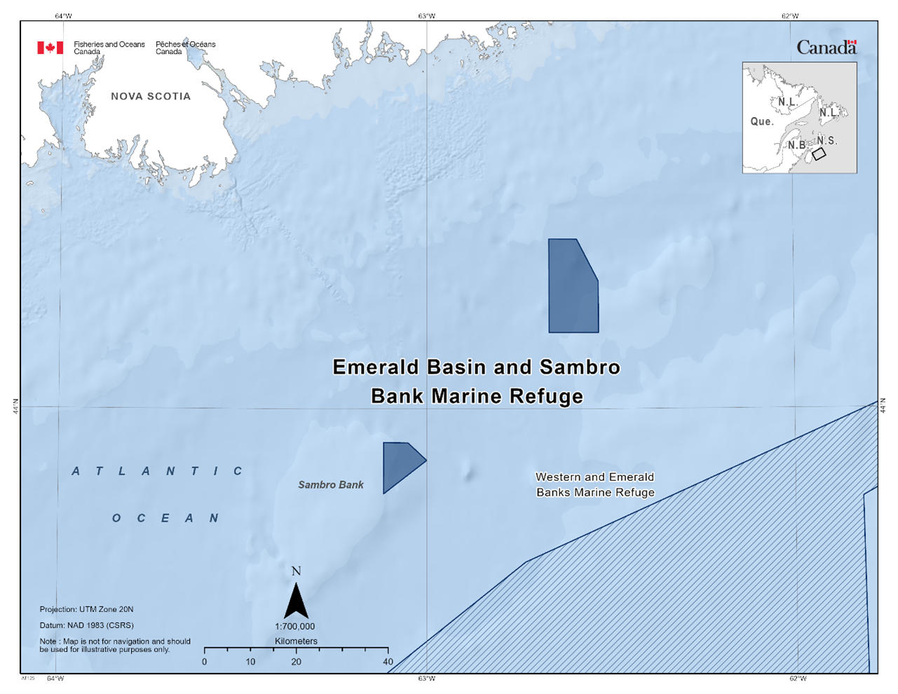
1.19 - Jordan Basin Marine Refuge
The Jordan Basin Marine Refuge can be found within the Scotian Shelf Bioregion. The fishery area closure was established in 2016 in licence conditions. This fishery area closure was granted marine refuge status due to the additional benefits it provides to protect cold water corals. The fishery area closure prohibits all commercial bottom-contact fishing gear.
Coordinates
The Jordan Basin Marine Refuge is approximately 49 km2 in size. The geographic boundary of this area is expressed in Latitude and Longitude and these point references are based on the Geodetic System North American Datum 1983 (NAD83). Positions are expressed in degrees, minutes and seconds. The Jordan Basin Marine Refuge is bounded by a line connecting the points in the order they are listed:
|
Point |
Latitude (North) |
Longitude (West) |
|
1 |
43° 20’ 30” |
67° 00’ 00” |
|
2 |
43° 17’ 30” |
67° 00’ 00” |
|
3 |
43° 15’ 30” |
67° 06’ 00” |
|
4 |
43° 17’ 30” |
67° 06’ 00” |
|
5 |
43° 20’ 30” |
67° 03’ 00” |
The Jordan Basin Marine Refuge in the map below:
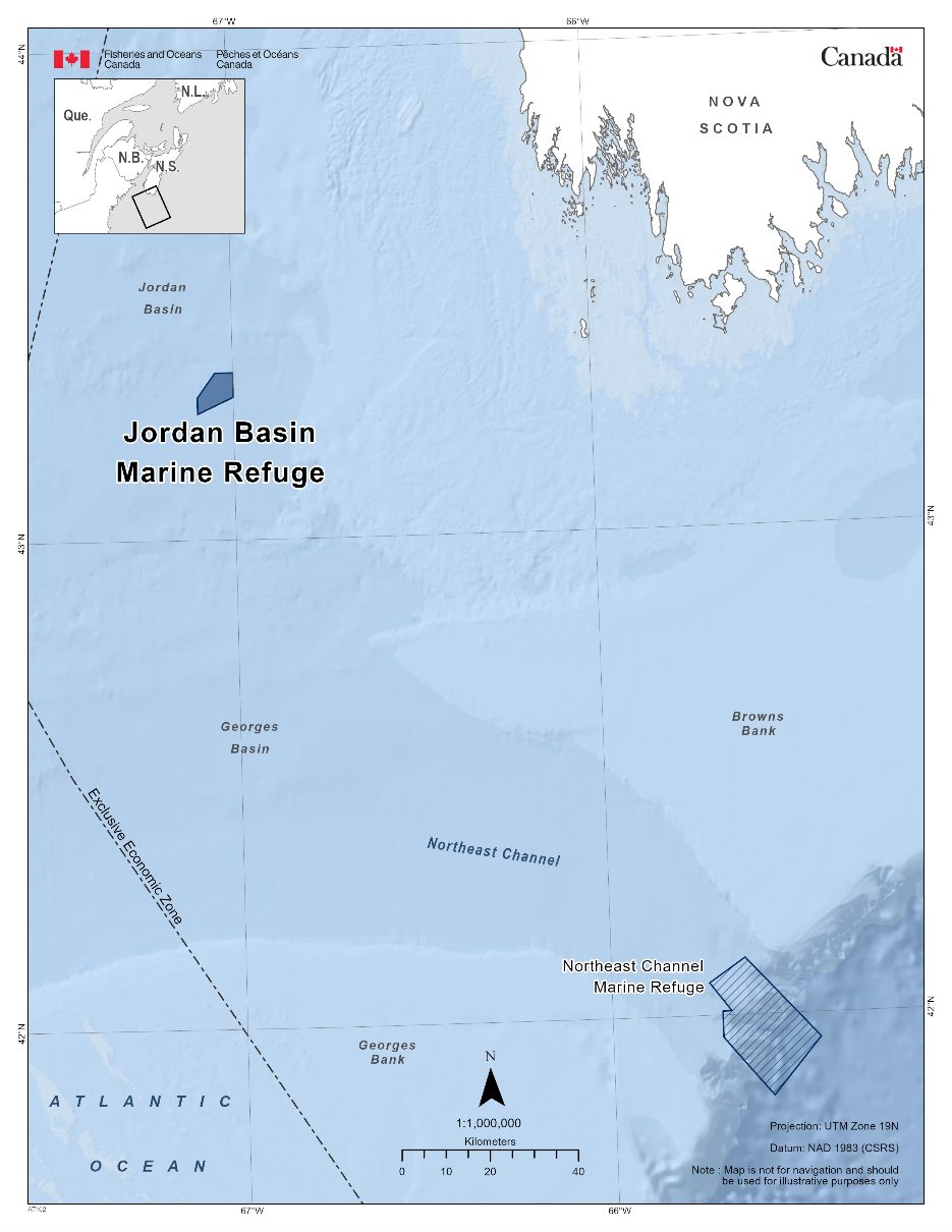
1.20 - Northeast Channel Marine Refuge
The Northeast Channel Marine Refuge can be found within the Scotian Shelf Bioregion. The fishery area closure was established in 2002 in licence conditions. This fishery area closure was granted marine refuge status due to the additional benefits it provides to protect cold water corals. The fishery area closure prohibits all commercial bottom-contact fishing gear.
Coordinates:
The Northeast Channel Marine Refuge is approximately 391 km2 in size. The geographic boundary of this area is expressed in Latitude and Longitude and these point references are based on the Geodetic System North American Datum 1983 (NAD83). Positions are expressed in degrees, minutes and seconds. The Northeast Channel Marine Refuge is bounded by a line connecting the points in the order they are listed:
|
Point |
Latitude (North) |
Longitude (West) |
|
1 |
42° 04′ 00″ |
65° 44′ 00″ |
|
2 |
42° 07′ 00″ |
65° 38′ 00″ |
|
3 |
41° 57′ 00″ |
65° 26′ 00″ |
|
4 |
41° 50′ 00″ |
65° 34′ 00″ |
|
5 |
41° 57′ 18″ |
65° 42′ 00″ |
|
6 |
42° 00′ 30″ |
65° 42′ 00″ |
|
7 |
42° 00′ 30″ |
65° 40′ 30″ |
The Northeast Channel Marine Refuge in the map below:
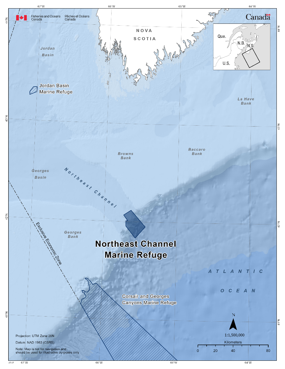
1.21 – Western and Emerald Banks Marine Refuge
The Western and Emerald Banks Marine Refuge can be found within the Scotian Shelf Bioregion. The fishery area closure was originally established in 1987 as a condition of licence and later revised in 2017. This fishery area closure was granted marine refuge status due to the additional benefits it provides to support productivity objectives for groundfish species of Aboriginal, commercial, and/or recreational importance, particularly NAFO Division 4VW haddock and manage the disturbance of benthic habitat that supports juvenile and adult haddock and other groundfish species. The fishery area closure prohibits all commercial and recreational fisheries using bottom-contact gear and/or gear known to interact with groundfish.
Coordinates
The Western and Emerald Banks Marine Refuge is approximately 10,234 km2 in size and is separated into two zones. Zone 1 of the Western and Emerald Banks Marine Refuge is bounded by a line connecting the points in the order they are listed. Zone 2 of the Western and Emerald Banks Marine Refuge is bounded by a line connecting the points in the order they are listed. The geographic boundary of this area is expressed in Latitude and Longitude and these point references are based on the Geodetic System North American Datum 1983 (NAD83). Positions are expressed in degrees, minutes and seconds.
Zone 1
|
Point |
Latitude (North) |
Longitude (West) |
|
1 |
43° 21’ 00” |
63° 20’ 00” |
|
2 |
43° 01’ 00” |
63° 20’ 00” |
|
3 |
43° 04’ 00” |
62° 30’ 00” |
|
4 |
43° 04’ 00” |
62° 00’ 00” |
|
5 |
43° 08’ 18” |
61° 48’ 00” |
|
6 |
43° 49’ 37” |
61° 49’ 00” |
|
7 |
43° 58’ 01” |
61° 28’ 00” |
|
8 |
43° 55’ 59” |
61° 18’ 00” |
|
9 |
44° 02’ 00” |
61° 18’ 00” |
|
10 |
44° 02’ 00” |
61° 42’ 00” |
|
11 |
43° 42’ 00” |
62° 44’ 00” |
|
12 |
43° 21’ 00” |
63° 20’ 00” |
Zone 2
|
Point |
Latitude (North) |
Longitude (West) |
|
1 |
43° 50' 00" |
61° 18' 00" |
|
2 |
43° 50' 00" |
61° 30' 00" |
|
3 |
43° 30' 00" |
61° 30' 00" |
|
4 |
43° 30' 00" |
61° 18' 00" |
The Western and Emerald Banks Marine Refuge in the map below:
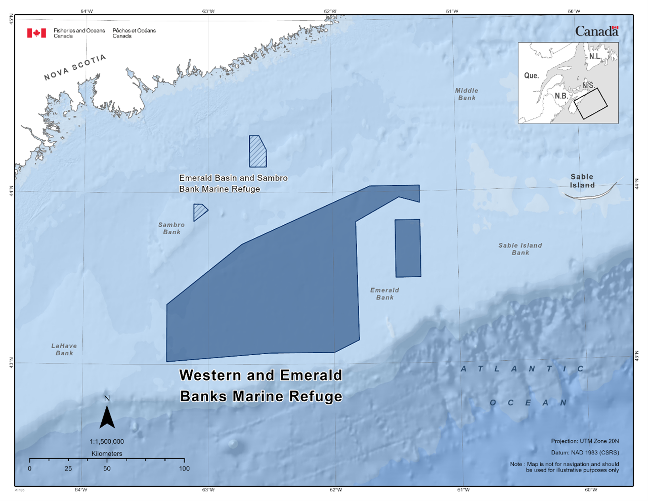
1.22 - Division 3O Coral Closure
The Division 3O Coral Closure can be found within the Newfoundland-Labrador Shelves Bioregion. The fishery area closure was established in 2008 as a licence condition. This fishery area closure was granted marine refuge status due to the additional benefits it provides to protect corals and sponges. The fishery area closure prohibits all bottom-contact fishing activities.
Coordinates
The Division 3O Coral Closure is approximately 10, 422 km2 in size. This site is located on the Grand Banks Slope in NAFO Subdivision 3O. Note that this is a portion of a larger closure extending beyond the exclusive economic zone. The geographic boundary of this area is expressed in Latitude and Longitude and these point references are based on the Geodetic System North American Datum 1983 (NAD83). Positions are expressed in degrees, minutes and seconds. The Division 3O Coral Closure is bounded by a line connecting the points in the order they are listed:
|
Point |
Latitude (North) |
Longitude (West) |
|
1 |
44° 49' 59.002" |
54° 30' 00.000" |
|
2 |
44° 18' 36.000" |
53° 24' 06.998" |
|
3 |
44° 18' 38.002" |
53° 06' 00.000" |
|
4 |
44° 04' 53.000" |
52° 58' 12.000" |
|
5 |
43° 56' 19.000" |
52° 39' 47.999" |
|
6 |
43° 40' 59.002" |
52° 27' 51.998" |
|
7 |
43° 39' 38.002" |
52° 13' 09.998" |
|
8 |
43° 24' 20.002" |
51° 58' 18.001" |
|
9 |
43° 24' 13.000" |
51° 58' 12.000" |
|
10 |
42° 52' 04.001" |
51° 31' 44.000" |
|
11 |
42° 52' 59.988" |
51° 00' 00.000" |
|
12 |
42° 33' 02.002" |
51° 00' 00.000" |
|
13 |
42° 48' 00.000" |
51° 41' 06.000" |
|
14 |
43° 26' 58.999" |
52° 55' 59.002" |
|
15 |
44° 29' 55.000" |
54° 30' 00.000" |
|
16 |
44° 49' 59.002" |
54° 30' 00.000" |
The Division 3O Coral Closure is shown in the map below:
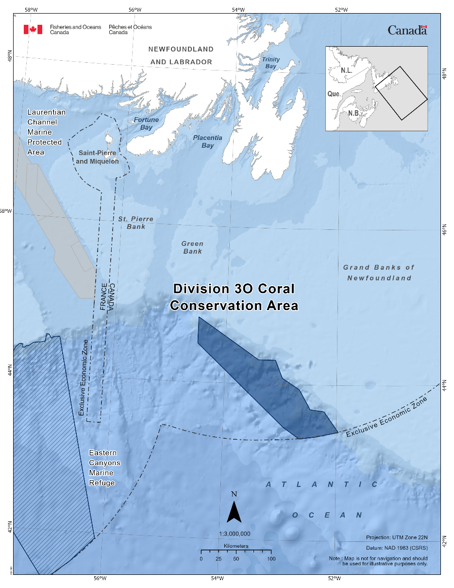
1.23 - Funk Island Deep Closure
The Funk Island Deep Closure can be found within the Newfoundland-Labrador Shelves Bioregion. The fishery area closure was established in 2002/2003 as a variation order and/or condition of licence. There is a significant overlap with this closure and the Notre Dame Channel Ecologically and Biologically Significant Area and some overlap with the Fogo Shelf Ecologically and Biologically Significant Area in the southern part of the closure. This fishery area closure was granted marine refuge status due to the additional benefits it provides to conserve benthic habitat and Atlantic cod. The fishery area closure prohibits bottom trawls, gillnets, cod pots, handlines, and longlines. However, crab pots are permitted.
Coordinates
The Funk Island Deep Closure is approximately 7, 274 km2 in size. Funk Island Deep Closure is located in NAFO Subdivision 3K. The geographic boundary of this area is expressed in Latitude and Longitude and these point references are based on the Geodetic System North American Datum 1983 (NAD83). Positions are expressed in degrees, minutes and seconds. The Funk Island Deep Closure is bounded by a line connecting the points in the order they are listed:
|
Point |
Latitude (North) |
Longitude (West) |
|
1 |
50° 49' 59.962" |
53° 20' 00.019" |
|
2 |
50° 49' 59.962" |
52° 40' 00.022" |
|
3 |
50° 29' 59.963" |
52° 40' 00.022" |
|
4 |
50° 29' 59.963" |
52° 30' 00.021" |
|
5 |
49° 39' 59.965" |
52° 30' 00.021" |
|
6 |
49° 39' 59.965" |
53° 20' 00.019" |
|
7 |
50° 49' 59.962" |
53° 20' 00.019" |
The Funk Island Deep Closure in the map below:
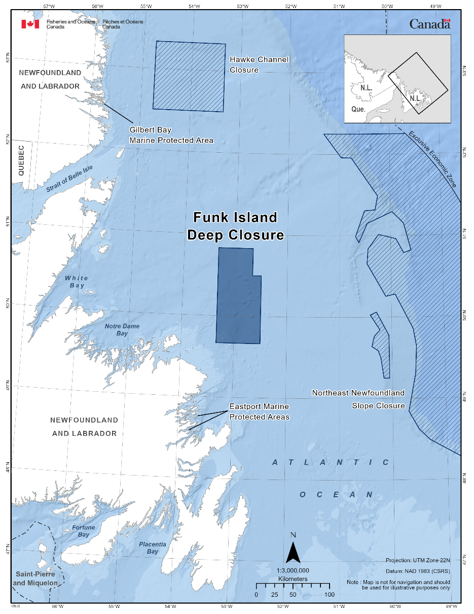
1.24 - Hawke Channel Closure
The Hawke Channel Closure can be found within the Newfoundland-Labrador Shelves Bioregion. The fishery area closure was established in 2002 as a variation order and/or condition of licence. The closure overlaps a significant portion of the Labrador Margin Trough Ecologically and Biologically Significant Area. This fishery area closure was granted marine refuge status due to the additional benefits it provides to conserve benthic habitat and Atlantic cod. The fishery area closure prohibits bottom trawl, gillnet, cod pots, handline, and longline fishing. However, crab pots are permitted.
Coordinates
The Hawke Channel Closure is approximately 8,837 km2 in size. The Hawke Channel Closure is located in NAFO Subdivision 2J. The geographic boundary of this area is expressed in Latitude and Longitude and these point references are based on the Geodetic System North American Datum 1983 (NAD83). Positions are expressed in degrees, minutes and seconds. The Hawke Channel Closure is bounded by a line connecting the points in the order they are listed:
|
Point |
Latitude (North) |
Longitude (West) |
|
1 |
53° 19' 59.960" |
54° 45' 00.018" |
|
2 |
53° 19' 59.960" |
53° 20' 00.019" |
|
3 |
52° 29' 59.962" |
53° 20' 00.019" |
|
4 |
52° 29' 59.962" |
54° 45' 00.018" |
|
5 |
53° 19' 59.960" |
54° 45' 00.018" |
The Hawke Channel Closure in the map below:
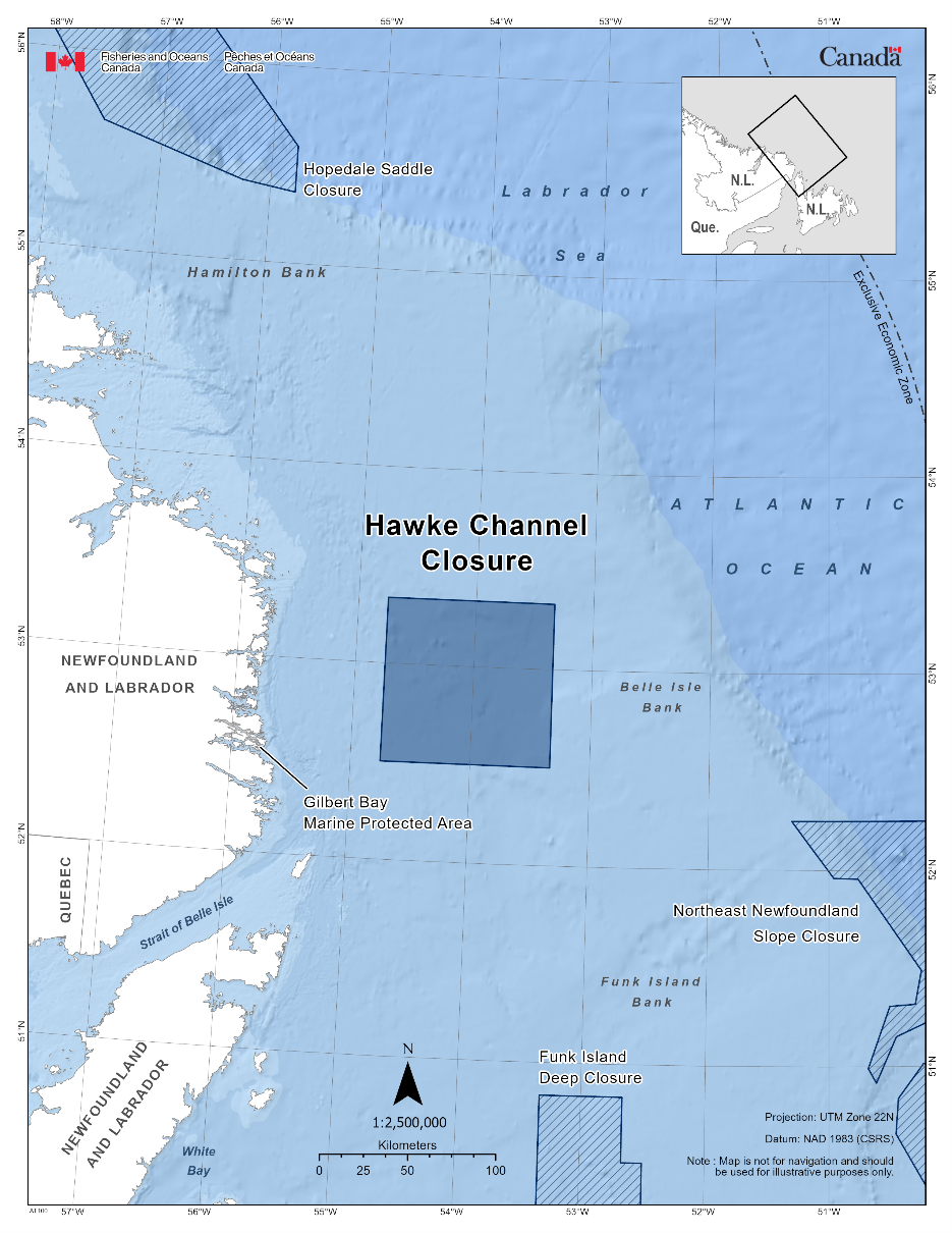
1.25 - Hopedale Saddle Closure
The Hopedale Saddle Closure can be found within the Newfoundland-Labrador Shelves Bioregion. The fishery area closure was established in 2017 as a variation order and/or condition of licence. This fishery area closure was granted marine refuge status due to the additional benefits it provides to protect corals and sponges and contribute to the long-term conservation of biodiversity. The fishery area closure prohibits all bottom-contact fishing activities.
Coordinates
The Hopedale Saddle Closure is approximately 15,410 km2 in size. The geographic boundary of this area is expressed in Latitude and Longitude and these point references are based on the Geodetic System North American Datum 1983 (NAD83). Positions are expressed in degrees, minutes and seconds. The Hopedale Saddle Closure is bounded by a line connecting the points in the order they are listed:
|
Point |
Latitude (North) |
Longitude (West) |
|
1 |
57° 43' 57.680" |
59° 04' 04.812" |
|
2 |
55° 35' 42.680" |
55° 46' 30.017" |
|
3 |
55° 21' 44.960" |
55° 46' 30.017" |
|
4 |
55° 24' 29.120" |
56° 15' 14.776" |
|
5 |
55° 39' 07.160" |
57° 31' 53.414" |
|
6 |
56° 12' 21.560" |
58° 11' 43.453" |
|
7 |
56° 10' 17.720" |
57° 28' 23.534" |
|
8 |
56° 23' 15.320" |
57° 24' 00.014" |
|
9 |
57° 03' 26.960" |
58° 58' 30.372" |
|
10 |
57° 40' 00.080" |
59° 28' 00.131" |
|
11 |
57° 43' 57.680" |
59° 04' 04.812" |
The Hopedale Saddle Closure in the map below:
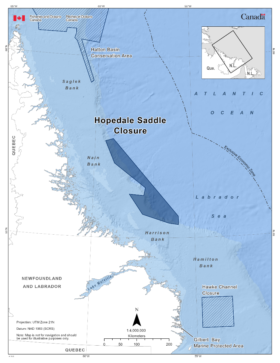
1.26 - Northeast Newfoundland Slope Closure
The Northeast Newfoundland Slope Closure can be found within the Newfoundland-Labrador Shelves Bioregion. The fishery area closure was established in 2017 as a variation order and/or condition of licence. This fishery area closure was granted marine refuge status due to the additional benefits it provides to protect corals and sponges and contribute to the long-term conservation of biodiversity. The fishery area closure prohibits all bottom-contact fishing activities.
Coordinates
The Northeast Newfoundland Slope Closure is approximately 55,353 km2 in size and is divided into two parts. The geographic boundary of this area is expressed in Latitude and Longitude and these point references are based on the Geodetic System North American Datum 1983 (NAD83). Positions are expressed in degrees, minutes and seconds. Part 1 of the Northeast Newfoundland Slope Closure is bounded by a line connecting the points in the order they are listed and subsequently follow the 200-mile limit boundary (EEZ) north returning to Point 30 to enclose the area. Part 2 of the Northeast Newfoundland Slope Closure is defined by straight lines joining the following points in the order in which they are listed.
Part 1
|
Point |
Latitude (North) |
Longitude (West) |
|
1 |
52° 15' 00.000" |
49° 40' 36.935" |
|
2 |
52° 15' 00.000" |
51° 18' 30.764" |
|
3 |
51° 57' 36.998" |
50° 57' 35.520" |
|
4 |
51° 57' 22.244" |
50° 45' 35.053" |
|
5 |
51° 29' 22.704" |
50° 14' 41.345" |
|
6 |
51° 19' 03.367" |
50° 17' 49.458" |
|
7 |
51° 18' 27.775" |
50° 30' 14.721" |
|
8 |
50° 59' 26.585" |
50° 40' 54.641" |
|
9 |
50° 55' 00.083" |
50° 37' 00.144" |
|
10 |
51° 09' 09.816" |
50° 27' 09.835" |
|
11 |
51° 17' 39.534" |
49° 57' 59.242" |
|
12 |
51° 09' 08.453" |
49° 44' 37.919" |
|
13 |
50° 49' 16.121" |
49° 36' 25.173" |
|
14 |
50° 47' 19.186" |
49° 45' 02.435" |
|
15 |
50° 57' 46.870" |
49° 53' 50.875" |
|
16 |
51° 00' 59.057" |
50° 14' 01.101" |
|
17 |
50° 50' 19.539" |
50° 26' 24.330" |
|
18 |
50° 39' 26.300" |
50° 27' 41.424" |
|
19 |
50° 24' 08.250" |
50° 14' 06.804" |
|
20 |
50° 15' 21.894" |
50° 06' 20.913" |
|
21 |
50° 16' 59.588" |
49° 55' 42.260" |
|
22 |
49° 51' 25.666" |
49° 35' 35.972" |
|
23 |
49° 38' 37.707" |
49° 32' 14.824" |
|
24 |
49° 18' 37.187" |
49° 33' 37.468" |
|
25 |
48° 50' 28.462" |
49° 41' 58.979" |
|
26 |
48° 37' 13.864" |
49° 30' 50.602" |
|
27 |
48° 29' 30.522" |
49° 19' 06.206" |
|
28 |
48° 06' 23.596" |
48° 18' 28.022" |
|
29 |
48° 06' 58.943" |
47° 45' 03.294" |
|
Follows the boundary of the Exclusive Economic Zone northerly to: |
||
|
30 |
52° 15' 00.000" |
49° 40' 36.935" |
Part 2
|
Point |
Latitude (North) |
Longitude (West) |
|
1 |
50° 03' 45.402" |
50° 17' 16.808" |
|
2 |
49° 46' 43.015" |
50° 03' 23.651" |
|
3 |
49° 27' 20.052" |
50° 03' 00.041" |
|
4 |
49° 15' 00.732" |
50° 03' 06.914" |
|
5 |
49° 15' 05.512" |
50° 09' 25.704" |
|
6 |
49° 29' 52.511" |
50° 12' 40.079" |
|
7 |
49° 35' 16.663" |
50° 15' 39.672" |
|
8 |
49° 38' 21.874" |
50° 22' 45.902" |
|
9 |
49° 46' 00.083" |
50° 19' 59.904" |
|
10 |
49° 50' 33.897" |
50° 13' 26.392" |
|
11 |
50° 01' 40.097" |
50° 24' 27.854" |
|
12 |
50° 03' 45.402" |
50° 17' 16.808" |
The Northeast Newfoundland Slope Closure in the map below:
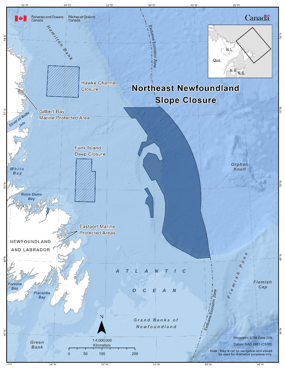
2 - Marine Refuges in the Pacific Region of Canada
The following section provides information on area-based measures that have been recognized as marine refuges in Pacific Canada.
2.1 - Banks Marine Refuge
The Banks Marine Refuge can be found within the Northern Shelf Bioregion in British Columbia. The fishery area closure was established in 2025 as a variation order under the Fisheries Act. This fishery area closure was granted marine refuge status due to the additional benefits it provides to rockfish and their habitat as well as corals and sponges to contribute to long-term conservation and species biodiversity. All Rockfish Conservation Areas closures remain in effect with commercial fishery prohibitions to fishing for salmon by troll, groundfish by means of bottom trawl, hook and line, mid-water trawl, or trap, tuna by hook and line, and shrimp by trawl. Recreational fishers are prohibited from fishing any species by spearfishing, groundfish by angling, salmon by trolling, jigging or mooching, octopus by angling, and squid by jigging. Additional fishery closures further prohibit commercial and recreational prawn and crab by trap fishing to protect rockfish and their habitat, corals, and sponges.
Coordinates
The Banks Marine Refuge is approximately 435.83 km2 in size. The geographic boundary of this area is expressed in Latitude and Longitude, and these point references are based on the Geodetic System North American Datum 1983 (NAD83). Positions are expressed in degrees, minutes, and seconds. The Banks marine refuge comprises three zones – Zone 305, 306, and 307.
Specifically, those waters of Area 105 and Subareas 5-20 and 5-22 that lie inside a line that:
|
Point |
Latitude (North) |
Longitude (West) |
Description |
|
Begins at |
53°27.900’ |
130°39.800’ |
In water |
|
Then to |
53°27.985’ |
130°35.246’ |
Bonilla Island |
|
Then to |
53°23.700’ |
130°22.700’ |
In water |
|
Then to |
53°18.700’ |
130°21.500’ |
In water |
|
Then to |
53°24.300’ |
130°38.000’ |
In water |
then to the beginning point.
Those waters of Subarea 105-2 that lie inside a line that:
|
Point |
Latitude (North) |
Longitude (West) |
Description |
|
Begins at |
53°15.900’ |
130°22.200’ |
In water |
|
Then to |
53°16.100’ |
130°16.700’ |
In water |
|
Then to |
53°10.000’ |
130°06.200’ |
In water |
|
Then to |
53°10.000’ |
130°19.110’ |
In water |
|
Then to |
53°11.881’ |
130°19.785’ |
In water |
|
Then to |
53°12.373’ |
130°21.662’ |
In water |
then to the beginning point.
Those waters of Subareas 6-9 and 106-1 that lie inside a line that:
|
Point |
Latitude (North) |
Longitude (West) |
Description |
|
Begins at |
53°09.835’ |
129°47.579’ |
South tip of Banks Island |
|
Then to |
53°05.100’ |
129°46.600’ |
In water |
|
Then to |
53°05.000’ |
129°50.100’ |
In water |
|
Then to |
53°08.600’ |
130°08.900’ |
In water |
|
Then to |
53°10.000’ |
130°08.900’ |
In water |
|
Then to |
53°10.000’ |
129°57.127’ |
Terror Point |
then following the southerly shoreline of Banks Island to the
beginning point.
The Banks Marine Refuge in the map below:
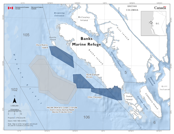
2.2 - G̱aw Ḵáahlii Marine Refuge
The G̱aw Ḵáahlii Marine Refuge can be found within the Northern Shelf Bioregion in Haida Gwaii, British Columbia. The fishery area closure was established in 2025 as a variation order under the Fisheries Act. This fishery area closure was granted marine refuge status due to the additional benefits it provides to ecologically and culturally important species and habitats, including multiple species of salmon, seabirds and their habitat, to contribute to long-term conservation and species biodiversity. The fishery area closures prohibit commercial and recreational fishing activities within the areas indicated on the map below (with the exception of recreational shore-based angling, which is permitted).
Coordinates
The G̱aw Ḵáahlii Marine Refuge is approximately 22.42 km2 in size. The geographic boundary of this area is expressed in Latitude and Longitude and these point references are based on the Geodetic System North American Datum 1983 (NAD83). Positions are expressed in degrees, minutes, and seconds. The G̱aw Ḵáahlii Marine Refuge is comprised of six zones within the inlet – zones 411-416. Each zone is bounded by a line connecting the points in the order they are listed below in the tables. Those portions of Subarea 1-6 that lie inside lines:
Maaman G̲ándlee (Mammin River) (Zone 411):
|
Point |
Description |
Latitude (North) |
Longitude (West) |
|
1 |
Commencing at a point in water at |
53° 37.804’ |
132° 18.775' |
|
2 |
then easterly to a point in water at |
53° 37.873' |
132° 18.071' |
|
3 |
then southerly to a point on land at |
53° 37.848' |
132° 18.067' |
|
4 |
then southerly following the shoreline to |
53° 36.881' |
132° 19.331' |
|
5 |
then northerly to a point in water at |
53° 37.323' |
132° 19.221' |
|
6 |
then northeasterly to the beginning point |
53° 37.804’ |
132° 18.775' |
Yahguu K̲adlee (Dawson Islands) (Zone 412):
|
Point |
Description |
Latitude (North) |
Longitude (West) |
|
1 |
Commencing at a point in water at |
53° 43.462' |
132° 21.075' |
|
2 |
then southeasterly to a point in water at |
53° 42.965' |
132° 20.001' |
|
3 |
then southwesterly to a point in water at |
53° 42.844' |
132° 20.274' |
|
4 |
then westerly to a point in water at |
53° 42.819' |
132° 21.257' |
|
5 |
then northwesterly to a point in water at |
53° 43.086' |
132° 21.732' |
|
6 |
then northeasterly to the beginning point |
53° 43.462' |
132° 21.075' |
Aayan G̱ándlee (Ain River) (Zone 413):
|
Point |
Description |
Latitude (North) |
Longitude (West) |
|
1 |
Commencing at a point on land at |
53° 44.573' |
132° 24.659' |
|
2 |
then southeasterly to a point in water at |
53° 44.328' |
132° 23.916' |
|
3 |
then southerly to a point on Kwaikans Island at |
53° 43.294' |
132° 24.927' |
|
4 |
then southwesterly to a point on McCreight Island at |
53° 42.260' |
132° 27.365' |
|
5 |
then westerly to a point on land at |
53° 42.414' |
132° 28.393' |
|
6 |
then following the shoreline to the beginning point |
53° 44.573' |
132° 24.659' |
Juus Káahlii South, Datl'aaman G̲andlee (Datlamen Creek) 1 (Zone 414):
|
Point |
Description |
Latitude (North) |
Longitude (West) |
|
1 |
Commencing at a point on land at |
53° 36.742' |
132° 27.661' |
|
2 |
then northeasterly to a point on land at |
53° 37.393' |
132° 23.520' |
|
3 |
then southerly following the shoreline to |
53° 34.255' |
132° 28.526' |
|
4 |
then easterly to a point on land at |
53° 34.253' |
132° 28.993' |
|
5 |
then northerly following the shoreline to the beginning point |
53° 36.742' |
132° 27.661' |
Juus Káahlii South, Datl'aaman G̲andlee (Datlamen Creek) 2 (Zone 415):
|
Point |
Description |
Latitude (North) |
Longitude (West) |
|
1 |
Commencing at a point on land at |
53° 34.253’ |
132° 28.993' |
|
2 |
then easterly to a point on land at |
53° 34.255' |
132° 28.526' |
|
3 |
then following the shoreline southerly then northerly to the beginning point |
53° 34.253’ |
132° 28.993' |
Aawan K̲áahlii (Awun Bay) (Zone 416):
|
Point |
Description |
Latitude (North) |
Longitude (West) |
|
1 |
Commencing at a point in water at |
53° 40.417' |
132° 34.226' |
|
2 |
then easterly to a point in water at |
53° 40.557' |
132° 31.780' |
|
3 |
then southerly to a point in water at |
53° 39.431' |
132° 30.352' |
|
4 |
then following the shoreline to a point on land at |
53° 40.014' |
132° 34.154' |
|
5 |
then northerly to the beginning point |
53° 40.417' |
132° 34.226' |
The G̱aw Ḵáahlii Marine Refuge in the map below:
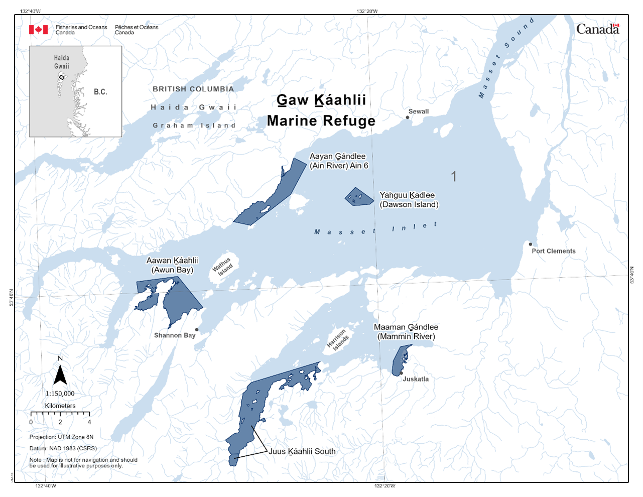
2.3 - Gwaxdlala/Nalaxdlala (Lull/Hoeya) Marine Refuge
The Gwaxdlala/Nalaxdlala (Lull/Hoeya) Marine Refuge is found within the Northern Shelf Bioregion. The fishery area closure was established in 2023 through a variation order. This fishery area closure was granted marine refuge status due to the additional benefits it provides to protect corals and sponges and contribute to long-term conservation and species biodiversity. The fishery area closure prohibits all commercial, recreational, or Food, Social, and Ceremonial fishing activities within the areas indicated on the map.
Coordinates
The Gwaxdlala/Nalaxdlala (Lull/Hoeya) Marine Refuge is approximately 21.38 km2 in size. The geographic boundary of this area is expressed in Latitude and Longitude and these point references are based on the Geodetic System North American Datum 1983 (NAD83). Positions are expressed in degree decimal minutes and all lines joining the geographical co-ordinates of points re interpreted as rhumb lines. That portion of Subarea 12-27 that lies inside a line that begins at:
|
Point |
Description |
Latitude (North) |
Longitude (West) |
|
1 |
Commencing at a point on land at |
50° 41.336' |
126° 02.560' |
|
2 |
then easterly following the shoreline into Lull Bay, then following the shoreline to |
50° 41.119' |
125° 57.484' |
|
3 |
then southerly to |
50° 39.979' |
125° 57.488' |
|
4 |
then westerly following the shoreline to |
50° 39.667' |
126° 02.558' |
|
5 |
then northerly to the beginning point |
50° 41.336' |
126° 02.560' |
The Gwaxdlala/Nalaxdlala (Lull/Hoeya) Marine Refuge is shown in the map below:
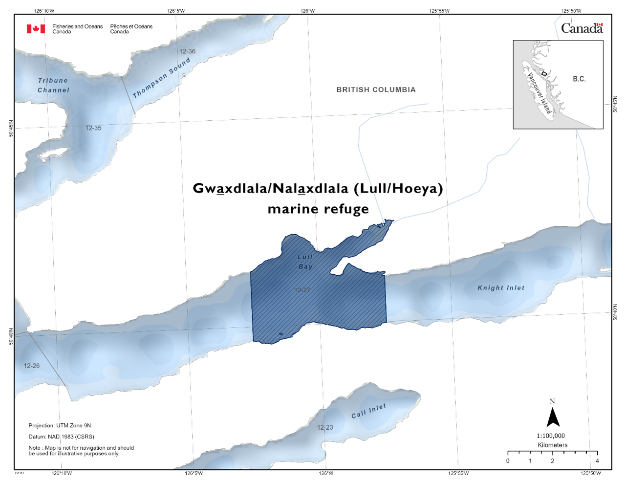
Additional Measures
The coral and sponge gardens are very fragile, in order to protect and conserve these gardens, other sensitive benthic habitat and the species that rely on them, in addition to the full fisheries closures noted above, avoid anchoring wherever possible. Furthermore, if you observe a fisheries violation, please reach out to the 24-hour hotline (1-800-465-4336) or email DFO.ORR-ONS.MPO@dfo-mpo.gc.ca
2.4 - Strait of Georgia & Howe Sound Glass Sponge Reefs Marine Refuges
The Strait of Georgia and Howe Sound Glass Sponge Reef are a combination of 17 fisheries area closures within the Strait of Georgia Bioregion. The Strait of Georgia Glass Sponge Reef closures were first established in 2015 for commercial and recreational bottom contact fishing activities and later updated in 2016 to include Indigenous fishing for Food, Social, and Ceremonial Purposes using bottom contact gear. This fishery area closure was granted marine refuge status due to the additional benefits it provides to protect glass sponge reefs. The fishery area closure prohibits all bottom-contact fishing in all reefs, and additionally, fishing using a downrigger in recreational salmon trolling in select reefs. This includes fishing for prawn, shrimp, crab, and groundfish (including halibut).
Coordinates
The Strait of Georgia and Howe Sound glass sponge reefs are part of the inland sea, the Salish Sea. Together, the Strait of Georgia (29.04 km2) and Howe Sound Glass Sponge Reefs (3.27 km2) are 32.6 km2 in size. Each closure encompasses one or more glass sponge reef footprint(s) and buffer zones extending at least 150 m beyond reef footprint(s).The Strait of Georgia & Howe Sound Glass Sponge Reef coordinates are as follows divided into 17 fisheries closure areas bounded by a rhumb line connecting the points in the order they are listed. The geographic boundary of this area is expressed in Latitude and Longitude and these point references are based on the Geodetic System North American Datum 1983 (NAD83). Positions are expressed in degrees, decimal minutes.
Parksville (Portions of Subareas 14-2 and 14-3)
|
Point |
Latitude (North) |
Longitude (West) |
|
1 |
49° 21.680' |
124° 19.762' |
|
2 |
49° 21.514' |
124° 18.893' |
|
3 |
49° 21.191' |
124° 17.723' |
|
4 |
49° 21.064' |
124° 17.724' |
|
5 |
49° 20.725' |
124° 18.380' |
|
6 |
49° 21.432' |
124° 19.811' |
|
7 |
49° 21.680' |
124° 19.762' |
East of Hornby Island (Achilles Bank, Portion of Subarea 14-6)
|
Point |
Latitude (North) |
Longitude (West) |
|
1 |
49° 33.490' |
124° 29.230' |
|
2 |
49° 32.701' |
124° 28.760' |
|
3 |
49° 31.657' |
124° 29.434' |
|
4 |
49° 31.663' |
124° 29.896' |
|
5 |
49° 32.651' |
124° 29.752' |
|
6 |
49° 33.340' |
124° 29.935' |
|
7 |
49° 33.498' |
124° 29.773' |
|
8 |
49° 33.490' |
124° 29.230' |
Gabriola Island (Portion of Subarea 17-11)
|
Point |
Latitude (North) |
Longitude (West) |
|
1 |
49° 13.672' |
123° 47.577' |
|
2 |
49° 13.235' |
123° 47.429' |
|
3 |
49° 13.185' |
123° 47.882' |
|
4 |
49° 13.391' |
123° 48.119' |
|
5 |
49° 13.623' |
123° 48.166' |
|
6 |
49° 13.672' |
123° 47.577' |
Outer Gulf Islands #1 (Portion of Subarea 29-4)
|
Point |
Latitude (North) |
Longitude (West) |
|
1 |
48° 54.936' |
123° 19.589' |
|
2 |
48° 54.283' |
123° 18.529' |
|
3 |
48° 54.114' |
123° 18.619' |
|
4 |
48° 54.065' |
123° 18.771' |
|
5 |
48° 54.787' |
123° 19.929' |
|
6 |
48° 54.902' |
123° 19.793' |
|
7 |
48° 54.936' |
123° 19.589' |
Outer Gulf Islands #2(Portion of Subarea 18-1)
|
Point |
Latitude (North) |
Longitude (West) |
|
1 |
48° 52.588' |
123° 15.261' |
|
2 |
48° 52.520' |
123° 14.537' |
|
3 |
48° 51.971' |
123° 13.768' |
|
4 |
48° 51.795' |
123° 13.947' |
|
5 |
48° 52.150' |
123° 14.444' |
|
6 |
48° 52.038' |
123° 14.678' |
|
7 |
48° 52.479' |
123° 15.521' |
|
8 |
48° 52.588' |
123° 15.261' |
Outer Gulf Islands #3 (Portion of Subarea 18-1)
|
Point |
Latitude (North) |
Longitude (West) |
|
1 |
48° 51.602' |
123° 13.233' |
|
2 |
48° 51.309' |
123° 12.751' |
|
3 |
48° 50.913' |
123° 12.938' |
|
4 |
48° 50.844' |
123° 13.059' |
|
5 |
48° 51.163' |
123° 13.662' |
|
6 |
48° 51.579’ |
123° 13.378' |
|
7 |
48° 51.602' |
123° 13.233' |
Outer Gulf Islands #4 (Portion of Subarea 18-1)
|
Point |
Latitude (North) |
Longitude (West) |
|
1 |
48° 50.999' |
123° 12.391' |
|
2 |
48° 50.608' |
123° 11.603' |
|
3 |
48° 50.097' |
123° 10.956' |
|
4 |
48° 49.959' |
123° 11.182' |
|
5 |
48° 50.857' |
123° 12.654' |
|
6 |
48° 50.959' |
123° 12.566' |
|
7 |
48° 50.999' |
123° 12.391' |
Sechelt Closure (Portion of Subarea
29-2)
|
Point |
Latitude (North) |
Longitude (West) |
|
1 |
49° 25.948' |
123° 48.889' |
|
2 |
49° 25.899' |
123° 47.266' |
|
3 |
49° 25.373' |
123° 46.494' |
|
4 |
49° 24.734' |
123° 47.083' |
|
5 |
49° 24.910' |
123° 47.951' |
|
6 |
49° 24.253' |
123° 48.283' |
|
7 |
49° 24.845' |
123° 49.914' |
|
8 |
49° 25.948' |
123° 48.889' |
Howe Sound-Defence Islands (Portion of Subarea 28-4)
|
Point |
Latitude (North) |
Longitude (West) |
|
1 |
49° 34.102' |
123° 17.070' |
|
2 |
49° 33.730' |
123° 16.562' |
|
3 |
49° 33.553' |
123° 16.462' |
|
4 |
49° 33.438' |
123° 16.750' |
|
5 |
49° 33.707' |
123° 17.201' |
|
6 |
49° 33.993' |
123° 17.391' |
|
7 |
49° 34.102' |
123° 17.070' |
Queen Charlotte Channel #1 – Howe Sound (Portion of Subarea 28-2)
|
Point |
Latitude (North) |
Longitude (West) |
|
1 |
49° 21.486' |
123° 17.254' |
|
2 |
49° 20.528' |
123° 17.690' |
|
3 |
49° 20.401' |
123° 17.956' |
|
4 |
49° 20.765' |
123° 18.794' |
|
5 |
49° 20.982' |
123° 18.584' |
|
6 |
49° 21.098' |
123° 18.037' |
|
7 |
49° 21.501' |
123° 17.737' |
|
8 |
49° 21.486' |
123° 17.254' |
Queen Charlotte Channel #2 – Howe Sound (Portions of Subareas 28-2 and 29-3)
|
Point |
Latitude (North) |
Longitude (West) |
|
1 |
49° 20.288' |
123° 17.693' |
|
2 |
49° 20.224' |
123° 17.501' |
|
3 |
49° 19.993' |
123° 17.377' |
|
4 |
49° 19.802' |
123° 17.444' |
|
5 |
49° 19.720' |
123° 17.840' |
|
6 |
49° 19.937' |
123° 18.107' |
|
7 |
49° 20.288' |
123° 17.693' |
Queen Charlotte Channel #3 – Howe Sound (Portion of Subarea 29-3)
|
Point |
Latitude (North) |
Longitude (West) |
|
1 |
49° 19.918' |
123° 19.847' |
|
2 |
49° 19.296' |
123° 19.905' |
|
3 |
49° 19.307' |
123° 20.344' |
|
4 |
49° 19.643' |
123° 20.421' |
|
5 |
49° 19.819' |
123° 20.361' |
|
6 |
49° 19.947' |
123° 20.097' |
|
7 |
49° 19.918' |
123° 19.847' |
Queen Charlotte Channel #4 – Howe Sound (Portions of Subareas 28-2 and 29-3)
|
Point |
Latitude (North) |
Longitude (West) |
|
1 |
49° 20.637' |
123° 19.162' |
|
2 |
49° 20.577' |
123° 18.720' |
|
3 |
49° 20.441' |
123° 18.637' |
|
4 |
49° 20.068' |
123° 18.818' |
|
5 |
49° 20.076' |
123° 19.135' |
|
6 |
49° 19.718' |
123° 19.187' |
|
7 |
49° 19.726' |
123° 19.514' |
|
8 |
49° 20.259' |
123° 19.828' |
|
9 |
49° 20.637' |
123° 19.162' |
Halibut Bank (Portion of Subarea 29-2)
|
Point |
Latitude (North) |
Longitude (West) |
|
1 |
49° 21.768' |
123° 41.501' |
|
2 |
49° 21.174' |
123° 40.045' |
|
3 |
49° 20.961' |
123° 40.139' |
|
4 |
49° 20.803' |
123° 39.860' |
|
5 |
49° 20.565' |
123° 40.182' |
|
6 |
49° 21.610' |
123° 41.843' |
|
7 |
49° 21.673' |
123° 42.643' |
|
8 |
49° 21.895' |
123° 43.908' |
|
9 |
49° 22.174' |
123° 44.748' |
|
10 |
49° 22.555' |
123° 44.456' |
|
11 |
49° 22.188 |
123° 42.167' |
|
12 |
49° 21.768' |
123° 41.501' |
Foreslope Hills (Portion of Subarea 29-3)
|
Point |
Latitude (North) |
Longitude (West) |
|
1 |
49° 09.634' |
123° 23.048' |
|
2 |
49° 09.389' |
123° 22.622' |
|
3 |
49° 09.187' |
123° 22.587' |
|
4 |
49° 09.211' |
123° 23.567' |
|
5 |
49° 09.646' |
123° 23.543' |
|
6 |
49° 09.634' |
123° 23.048' |
East Defence Islands (Portion of Subarea 28-4)
|
Point |
Latitude (North) |
Longitude (West) |
|
1 |
49° 34.731’ |
123° 16.555’ |
|
2 |
49° 34.848’ |
123° 16.357’ |
|
3 |
49° 34.854’ |
123° 16.120’ |
|
4 |
49° 34.580’ |
123° 16.084’ |
|
5 |
49° 34.535’ |
123° 16.539’ |
|
6 |
49° 34.731’ |
123° 16.555’ |
Anvil Island (Portion of Subarea 28-4)
|
Point |
Latitude (North) |
Longitude (West) |
|
1 |
49° 32.874’ |
123° 17.425’ |
|
2 |
49° 32.865’ |
123° 16.815’ |
|
3 |
49° 32.533’ |
123° 16.869’ |
|
4 |
49° 32.482’ |
123° 17.118’ |
|
5 |
49° 32.574’ |
123° 17.483’ |
|
6 |
49° 32.874’ |
123° 17.425’ |
Lost Reef (Portion of Subarea 28-2)
|
Point |
Latitude (North) |
Longitude (West) |
|
1 |
49° 29.799’ |
123° 18.203’ |
|
2 |
49° 29.935’ |
123° 18.007’ |
|
3 |
49° 29.882’ |
123° 17.832’ |
|
4 |
49° 29.591’ |
123° 17.519’ |
|
5 |
49° 29.547’ |
123° 17.941’ |
|
6 |
49° 29.799’ |
123° 18.203’ |
Brunswick Point (Portion of Subarea 28-2)
|
Point |
Latitude (North) |
Longitude (West) |
|
1 |
49° 28.577’ |
123° 14.965 |
|
2 |
49° 28.434’ |
123° 14.732’ |
|
3 |
49° 28.177’ |
123° 15.031’ |
|
4 |
49° 28.397’ |
123° 15.377’ |
|
5 |
49° 28.577’ |
123° 14.965 |
Lions Bay and Kelvin Grove (Portion of Subarea 28-2)
|
Point |
Latitude (North) |
Longitude (West) |
|
1 |
49° 27.629’ |
123° 15.761’ |
|
2 |
49° 27.315’ |
123° 14.516’ |
|
3 |
49° 26.950’ |
123° 14.595’ |
|
4 |
49° 26.952’ |
123° 15.046’ |
|
5 |
49° 27.195’ |
123° 15.655’ |
|
6 |
49° 27.629’ |
123° 15.761’ |
Halkett Point (Portion of Subarea 28-2)
|
Point |
Latitude (North) |
Longitude (West) |
|
1 |
49° 27.036’ |
123° 18.686‘ |
|
2 |
49° 26.897’ |
123° 18.444’ |
|
3 |
49° 26.696’ |
123° 18.578’ |
|
4 |
49° 26.657’ |
123° 18.776’ |
|
5 |
49° 26.742’ |
123° 18.984’ |
|
6 |
49° 27.036’ |
123° 18.686‘ |
Bowyer Island (Portion of Subarea 28-2)
|
Point |
Latitude (North) |
Longitude (West) |
|
1 |
49° 24.774’ |
123° 16.219’ |
|
2 |
49° 24.820’ |
123° 15.763’ |
|
3 |
49° 24.096’ |
123° 16.043’ |
|
4 |
49° 24.389’ |
123° 16.408’ |
|
5 |
49° 24.774’ |
123° 16.219’ |
Dorman Point (Portion of Subarea 28-2)
|
Point |
Latitude (North) |
Longitude (West) |
|
1 |
49° 22.577’ |
123° 19.379’ |
|
2 |
49° 22.543’ |
123° 19.051’ |
|
3 |
49° 22.287’ |
123° 19.152’ |
|
4 |
49° 22.351’ |
123° 19.454’ |
|
5 |
49° 22.577’ |
123° 19.379’ |
The Strait of Georgia and Howe Sound Glass Sponge Reef Marine Refuge is shown in the map below:
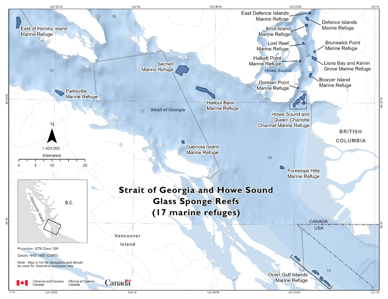
Additional Measures
The glass sponge reefs are very fragile, in order to protect and conserve these reefs and the species that rely on them, avoid anchoring wherever possible, and do not fish. Furthermore, if you observe fisheries violations, please reach out to the 24 hour hotline (1-800-465-4336) or email DFO.ORR-ONS.MPO@dfo-mpo.gc.ca.
2.5 - X̲aana K̲aahlii Marine Refuge
The X̲aana K̲aahlii Marine Refuge can be found within the Northern Shelf Bioregion in Haida Gwaii, British Columbia. The fishery area closure was established in 2025 as a variation order under the Fisheries Act. This fishery area closure was granted marine refuge status due to the additional benefits it provides to ecologically and culturally important species and habitats, including multiple species of salmon, seabirds and their habitat, to contribute to long-term conservation and species biodiversity. The fishery area closures prohibit commercial and recreational fishing activities within the areas indicated on the map below (with the exception of recreational shore-based angling, which is permitted).
Coordinates of the X̲aana K̲aahlii Marine Refuge
The X̲aana K̲aahlii Marine Refuge is approximately 7.16 km2 in size. The geographic boundary of this area is expressed in Latitude and Longitude, and these point references are based on the Geodetic System North American Datum 1983 (NAD83). Positions are expressed in degrees, minutes, and seconds. The X̲aana K̲aahlii Marine Refuge is comprised of three zones within the inlet – zones 422, 423, and 424. Each zone is bounded by a line connecting the points in the order listed in the tables below. Those portions of Subarea 2-1 that lie inside lines:
G̲andlaay Sɢ̲aagiidaay (Slatechuk Creek) (Zone 422):
|
Point |
Description |
Latitude (North) |
Longitude (West) |
|
1 |
Commencing at a point on land at |
53° 13.649’ |
132° 13.500' |
|
2 |
Then southerly to a point on land at |
53° 13.303' |
132° 13.595' |
|
3 |
Then southerly to a point on land |
53° 13.056’ |
132° 14.151' |
|
4 |
Then easterly to a point on land at |
53° 13.129' |
132° 14.603' |
|
5 |
Then northerly to the beginning point |
53° 13.649’ |
132° 13.500' |
Diina (Deena Creek) (Zone 423):
|
Point |
Description |
Latitude (North) |
Longitude (West) |
|
1 |
Commencing at a point in water at |
53° 09.415’ |
132° 06.870’ |
|
2 |
Then southeasterly to a point on land at |
53° 09.105’ |
132° 05.650’ |
|
3 |
Then westerly following a shoreline to a point on land |
53° 09.246’ |
132° 07.064' |
|
4 |
Then northerly to a point on land at |
53° 09.306' |
132° 07.036' |
|
5 |
Then northerly to a point on land |
53° 09.381' |
132° 06.947' |
|
6 |
Then northerly to the beginning point |
53° 09.415’ |
132° 06.870’ |
Hlɢ̲aagilda Llnagaay Sɢ̲aagiidaay (Skidegate) (Zone 424):
|
Point |
Description |
Latitude (North) |
Longitude (West) |
|
1 |
Commencing at a point on land at |
53° 17.933’ |
131° 57.984’ |
|
2 |
Then easterly to a point in water at |
53° 17.887’ |
131° 57.517’ |
|
3 |
Then southerly to a point in water at |
53° 15.335’ |
131° 58.180’ |
|
4 |
Then southerly to a point in water at |
53° 14.616’ |
131° 58.830’ |
|
5 |
Then northwesterly to a point on land at |
53° 14.856’ |
131° 59.749’ |
|
6 |
Then northerly following the shoreline to the beginning point |
53° 17.933’ |
131° 57.984’ |
The X̲aana K̲aahlii Marine Refuge in the map below:
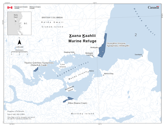
3 - Marine Refuges in the Canadian Arctic
The following section provides information on area-based measures that have been recognized as marine refuges in Arctic Canada.
3.1 - Davis Strait Marine Refuge
The Davis Strait Marine Refuge is found adjacent to Nunavut within the Eastern Arctic Bioregion. The fishery area closure was established in 2017 as a licence condition and variation order. This fishery area closure was granted marine refuge status due to the additional benefits it provides to conserve sensitive benthic areas. The fishery area closure prohibits all bottom-contact fishing activities.
Coordinates
The Davis Strait Marine Refuge is approximately 17, 298 km2 in size. The geographic boundary of this area is expressed in Latitude and Longitude and these point references are based on the Geodetic System North American Datum 1983 (NAD83). Positions are expressed in degrees, minutes and seconds. The area (in Divisions 0A and 0B) is bounded by a line joining the following points in the order in which they are listed:
|
Point |
Latitude (North) |
Longitude (West) |
|
1 |
66° 41' 06.100" |
57° 40' 12.300" |
|
2 |
66° 37' 52.600" |
57° 39' 27.100" |
|
3 |
66° 36' 01.000" |
57° 38' 59.200" |
|
4 |
66° 30' 16.300" |
57° 38' 02.100" |
|
5 |
66° 24' 30.000" |
57° 37' 33.600" |
|
6 |
66° 18' 40.900" |
57° 37' 33.200" |
|
7 |
66° 15' 00.000" |
57° 37' 50.400" |
|
8 |
66° 12' 50.400" |
57° 37' 00.500" |
|
9 |
66° 03' 29.800" |
57° 39' 27.300" |
|
10 |
65° 57' 37.000" |
57° 39' 55.600" |
|
11 |
65° 57' 30.000" |
57° 39' 55.600" |
|
12 |
65° 51' 44.900" |
57° 40' 26.400" |
|
13 |
65° 50' 48.600" |
57° 40' 27.400" |
|
14 |
65° 37' 35.300" |
57° 41' 44.700" |
|
15 |
65° 34' 44.700" |
57° 42' 10.600" |
|
16 |
65° 23' 19.500" |
57° 44' 49.900" |
|
17 |
65° 18' 05.000" |
57° 45' 41.800" |
|
18 |
65° 14' 31.300" |
57° 44' 59.500" |
|
19 |
65° 11' 29.700" |
57° 44' 13.200" |
|
20 |
65° 08' 47.400" |
57° 43' 41.200" |
|
21 |
65° 06' 02.500" |
57° 43' 57.100" |
|
22 |
64° 33' 22.400" |
57° 46' 29.200" |
|
23 |
64° 23' 30.400" |
58° 50' 16.200" |
|
24 |
64° 13' 36.400" |
58° 49' 23.000" |
|
25 |
64° 06' 00.500" |
59° 26' 00.200" |
|
26 |
65° 56' 00.000" |
59° 04' 00.200" |
|
27 |
66° 21' 00.000" |
59° 29' 00.000" |
|
28 |
66° 41' 06.100" |
57° 40' 12.300" |
The Davis Strait Marine Refuge is shown in the map below:
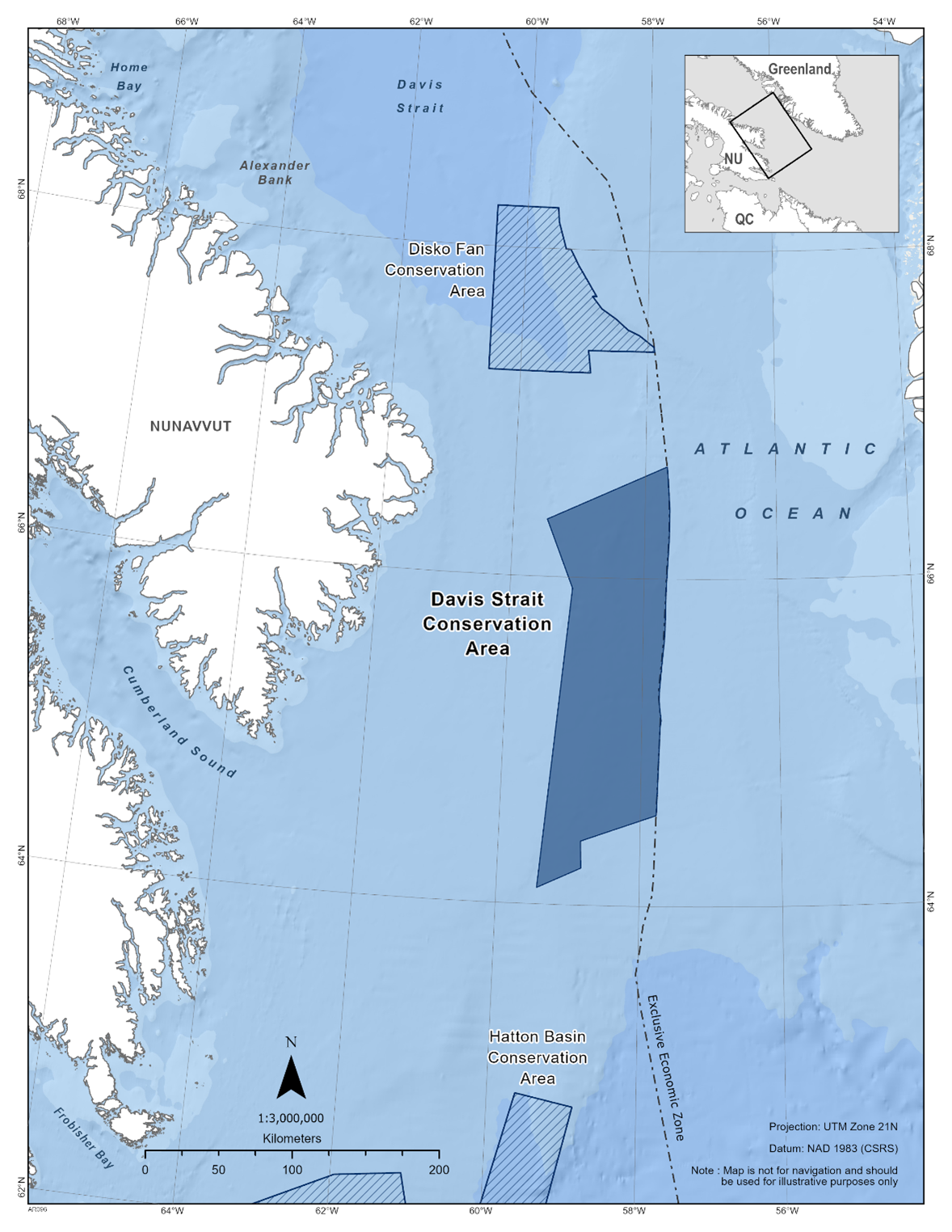
Additional Measures
All commercial fishing vessels operating in NAFO Subarea 0 are
required to carry a Vessel Monitoring System. This data is
monitored regularly to aid compliance monitoring of the fishery
closure. As well air surveillance is conducted. Other
complementary tools (e.g. At-sea Observers, fishing logbooks) are
also employed.
Voluntary Measures
1.Vessels should avoid passage through this area if possible. Avoidance is the most effective means to eliminate or reduce acoustic disturbances and vessel collisions to marine mammals.
2.Vessels should adhere to the following operating measures while maneuvering around marine mammals:
a.Avoid any sudden changes in speed or direction.
b.Avoid heading directly toward marine mammals.
c.Travel parallel to marine mammals.
d.If it is not possible to maneuver around a marine
mammal or group of marine mammals, slow down immediately,
maintain a minimum distance of 100 metres and wait until
animals are more than 400 metres away before slowly resuming
speed.
e.If operating a sailing vessel with an auxiliary motor, leave it in idle or use the echo sounder to signal presence.
3.Vessels must comply with all relevant provisions of
the Marine Mammal Regulations pursuant to
the Fisheries Act.
4.Marine mammal collisions, entanglements, distressed or
dead animals should be reported to the Marine Animal Response
Society’s emergency hotline (1-866-567-6277), or via VHF
channel 16. Sightings of healthy marine mammals should be
reported to XMARwhalesightings@dfo-mpo.gc.ca.
The following information about the sighting should be
included: date, time, location, and species. Photos and videos
should be submitted if available.
5.Please ensure that you are mitigating any risk of
bottom contact in these sensitive areas. Anchoring is
discouraged in the marine refuges if possible. Anchoring will
be accepted for any safety reasons.
6.Please ensure that you are mitigating any risk of
bottom contact in these sensitive areas. Anchoring is
discouraged in the marine refuges if possible, to avoid.
Anchoring will be accepted for any safety reasons.
3.2 - Disko Fan Marine Refuge
The Disko Fan Marine Refuge is found adjacent to Nunavut within the southern Baffin Bay in the Eastern Arctic Bioregion. Originally called the Narwhal Overwintering and Coldwater Coral Zone, it was closed to all Greenland Halibut fishing in 2008 via variation order and licence conditions, but allowed for shrimp fishing at shallower depths (<400m). In 2017, this fishery area closure was renamed to Disko Fan Marine Refuge and the area closed to all fishing activity; it was granted marine refuge status due to the additional benefits it provides to conserve coral concentrations and minimize impacts on winter food source and overwintering habitat for narwhal.
Coordinates
The Disko Fan Marine Refuge is approximately 7,485 km2 in size. The geographic boundary of this area is expressed in Latitude and Longitude and these point references are based on the Geodetic System North American Datum 1983 (NAD83). Positions are expressed in degrees, minutes and seconds. The Disko Fan Marine Refuge (in NAFO Divisions 0A) is bounded by a line joining the following points in the order in which they are listed:
|
Point |
Latitude (North) |
Longitude (West) |
|
1 |
68° 15' 00.000" |
59° 30' 00.000" |
|
2 |
68° 10' 00.000" |
59° 29' 00.000" |
|
3 |
68° 00' 00.000" |
59° 21' 00.000" |
|
4 |
68° 00' 00.000" |
59° 16' 30.000" |
|
5 |
67° 54' 00.000" |
59° 08' 00.000" |
|
6 |
67° 43' 00.000" |
58° 50' 00.000" |
|
7 |
67° 43' 00.000" |
58° 54' 00.000" |
|
8 |
67° 38' 30.000" |
58° 44' 30.000" |
|
9 |
67° 35' 00.000" |
58° 31' 00.000" |
|
10 |
67° 31' 00.000" |
58° 19' 00.000" |
|
11 |
67° 29' 00.000" |
58° 08' 00.000" |
|
12 |
67° 24' 50.000" |
57° 53' 37.700" |
|
13 |
67°23' 08.000" |
57°52' 58.200" |
|
14 |
67°23' 08.000" |
58°56' 14.600" |
|
15 |
67°15' 00.000" |
58°53' 37.400" |
|
16 |
67°15' 00.000" |
60°30' 00.000" |
|
17 |
68°15' 00.000" |
60°30' 00.000" |
|
18 |
68°15' 00.000" |
59°30' 00.000" |
The Disko Fan Marine Refuge is shown in the map below:
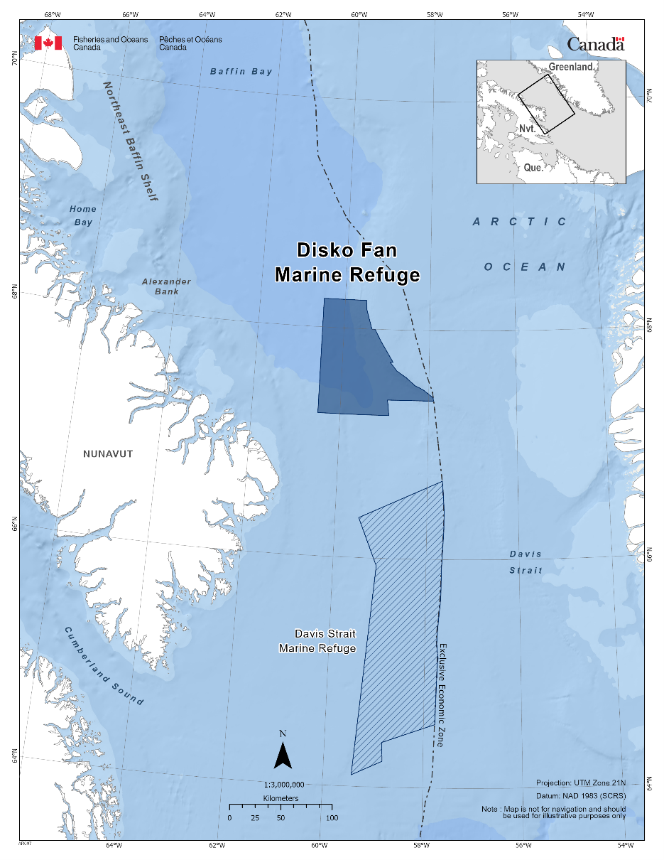
Additional Measures
All commercial fishing vessels operating in NAFO Subarea 0 are required to carry a Vessel Monitoring System. This data is monitored regularly to aid compliance monitoring of the fishery closure. As well air surveillance is conducted. Other complementary tools (e.g. At-sea Observers, fishing logbooks) are also employed.
Voluntary Measures
1.Vessels should avoid passage through this area if
possible. Avoidance is the most effective means to eliminate or
reduce acoustic disturbances and vessel collisions to marine
mammals.
2.If passage through this area is required, vessel speed
should decrease to 10 knots or less and post a look-out to
increase the likelihood of sighting and avoiding marine
mammals. Increased caution should be exercised in conditions of
reduced visibility, such as rain, fog, rough sea state, or at
night. Be aware that marine mammals often travel in small
groups dispersed over an area of several miles.
3.Vessels should adhere to the following operating
measures while maneuvering around marine mammals:
a.Avoid any sudden changes in speed or direction.
b.Avoid heading directly toward marine mammals.
c.Travel parallel to marine mammals.
d.If it is not possible to maneuver around a marine
mammal or group of marine mammals, slow down immediately,
maintain a minimum distance of 100 metres and wait until
animals are more than 400 metres away before slowly resuming
speed.
e.If operating a sailing vessel with an auxiliary motor, leave it in idle or use the echo sounder to signal presence.
4.Vessels must comply with all relevant provisions of
the Marine Mammal Regulations pursuant to
the Fisheries Act.
5.Marine mammal collisions, entanglements, distressed or
dead animals should be reported to the Marine Animal Response
Society’s emergency hotline (1-866-567-6277), or via VHF
channel 16. Sightings of healthy marine mammals should be
reported to XMARwhalesightings@dfo-mpo.gc.ca.
The following information about the sighting should be
included: date, time, location, and species. Photos and videos
should be submitted if available.
6.Please ensure that you are mitigating any risk of bottom contact in these sensitive areas. Anchoring is discouraged in the marine refuges if possible, to avoid. Anchoring will be accepted for any safety reasons.
3.3 - Hatton Basin Marine Refuge
The Hatton Basin Marine Refuge can be found in the Eastern Arctic and Newfoundland-Labrador Shelves Bioregions. The fishery area closure was established in 2017 as a variation order and licence of condition. This fishery area closure was granted marine refuge status due to the additional benefits it provides to conserve cold-water corals and sponges. The fishery area closure prohibits all bottom-contact fishing activities. This area is the only known overwintering area for northern Hudson Bay narwhal.
Coordinates
The Hatton Basin Marine Refuge is approximately 42,459 km2 in size. The geographic boundary of this area is expressed in Latitude and Longitude and these point references are based on the Geodetic System North American Datum 1983 (NAD83). Positions are expressed in degrees, minutes and seconds. The Hatton Basin Marine Refuge (in NAFO Divisions 0B and 2G) is bounded by a line connecting the points in the order they are listed:
|
Point |
Latitude (North) |
Longitude (West) |
|
1 |
62° 16' 49.758" |
61° 56' 38.046" |
|
2 |
62° 19' 06.918" |
61° 04' 22.448" |
|
3 |
61° 29' 59.958" |
60° 41' 55.329" |
|
4 |
61° 29' 59.958" |
60° 22' 07.689" |
|
5 |
62° 50' 31.518" |
59° 37' 08.050" |
|
6 |
62° 45' 58.278" |
58° 51' 02.172" |
|
7 |
60° 22' 28.159" |
60° 00' 24.490" |
|
8 |
60° 26' 32.959" |
61° 01' 12.728" |
|
9 |
59° 28' 37.519" |
60° 19' 03.010" |
|
10 |
59° 19' 14.839" |
60° 12' 22.690" |
|
11 |
59° 15' 45.679" |
60° 20' 53.530" |
|
12 |
60° 23' 43.399" |
61° 15' 03.968" |
|
13 |
60° 28' 06.199" |
61° 24' 18.368" |
|
14 |
60° 36' 37.399" |
61° 19' 33.968" |
|
15 |
60° 44' 01.279" |
61° 20' 14.288" |
|
16 |
60° 44' 00.559" |
61° 51' 41.767" |
|
17 |
60° 37' 00.799" |
61° 53' 53.527" |
|
18 |
60° 36' 22.639" |
63° 27' 37.804" |
|
19 |
60° 57' 04.639" |
63° 35' 00.244" |
|
20 |
61° 10' 15.199" |
63° 56' 15.003" |
|
21 |
61° 51' 01.038" |
63° 54' 12.963" |
|
22 |
62° 16' 49.758" |
61° 56' 38.046" |
The Hatton Basin Marine Refuge is shown in the map below:
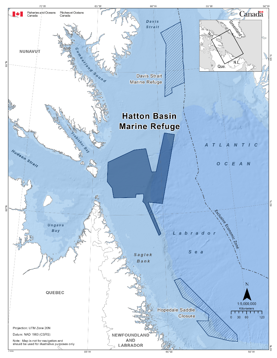
Additional Measures
Voluntary Measures
1.Vessels should avoid passage through this area if possible. Avoidance is the most effective means to eliminate or reduce acoustic disturbances and vessel collisions to marine mammals.
2.If passage through this area is required, vessel speed
should decrease to 10 knots or less and post a look-out to
increase the likelihood of sighting and avoiding marine
mammals. Increased caution should be exercised in conditions of
reduced visibility, such as rain, fog, rough sea state, or at
night. Be aware that marine mammals often travel in small
groups dispersed over an area of several miles.
3.Vessels should adhere to the following operating
measures while maneuvering around marine mammals:
a.Avoid any sudden changes in speed or direction.
b.Avoid heading directly toward marine mammals.
c.Travel parallel to marine mammals.
d.If it is not possible to maneuver around a marine
mammal or group of marine mammals, slow down immediately,
maintain a minimum distance of 100 metres and wait until
animals are more than 400 metres away before slowly resuming
speed.
e.If operating a sailing vessel with an auxiliary motor,
leave it in idle or use the echo sounder to signal presence.
4.Vessels must comply with all relevant provisions of
the Marine Mammal Regulations pursuant to
the Fisheries Act.
5.Marine mammal collisions, entanglements, distressed or
dead animals should be reported to the Marine Animal Response
Society’s emergency hotline (1-866-567-6277), or via VHF
channel 16. Sightings of healthy marine mammals should be
reported to XMARwhalesightings@dfo-mpo.gc.ca.
The following information about the sighting should be
included: date, time, location, and species. Photos and videos
should be submitted if available.
6.Please ensure that you are mitigating any risk of bottom contact in these sensitive areas. Anchoring is discouraged in the marine refuges if possible, to avoid. Anchoring will be accepted for any safety reasons.
Report a problem on this page
- Date modified: