
Archived information
The Standard on Web Usability replaces this content. This content is archived because Common Look and Feel 2.0 Standards have been rescinded.
Archived information is provided for reference, research or recordkeeping purposes. It is not subject to the Government of Canada Web Standards and has not been altered or updated since it was archived.
NOTICES TO MARINERS
PUBLICATION
WESTERN EDITION
October 25, 2019

Safety First, Service Always
Published Monthly by the
CANADIAN COAST GUARD
www.notmar.gc.ca/subscribe/
CONTENTS
| Section 1 | General and Safety Information |
| Section 2 | Chart Corrections |
| Section 3 | Radio Aids to Marine Navigation Corrections |
| Section 4 | Sailing Directions and Small Craft Guide Corrections |
| Section 5 | List of Lights, Buoys and Fog Signals Corrections |
Canadian Coast Guard Programs
Aids to Navigation and Waterways
Fisheries and Oceans Canada
Montreal, Quebec
H2Y 2E7
© Her Majesty the Queen in Right of Canada, 2019
DFO/2019-2026
Fs152-6E-PDF
ISSN 1719-7708
Disponible en français :
Publication des Avis aux navigateurs
Édition de l'Ouest
Édition mensuelle Nº10/2019
Fisheries and Oceans Canada
Official Publication of the Canadian Coast Guard
DFO/2019-2026
EXPLANATORY NOTES
Geographical positions refer directly to the graduations of the largest scale Canadian Hydrographic chart unless otherwise indicated.
Bearings refer to the true compass and are measured clockwise from 000° (North) clockwise to 359°; those relating to lights are from seaward.
Visibility of lights is that in clear weather.
Depths - The units used for soundings (metres, fathoms or feet) are stated in the title of each chart.
Elevations are normally given above Higher High Water, Large Tide unless otherwise indicated.
Distances may be calculated as follows:
1 nautical mile = 1,852 metres (6,076.1 feet)
1 statute mile = 1,609.3 metres (5,280 feet)
1 metre = 3.28 feet
Temporary & Preliminary Notices are indicated by a (T) or a (P) in Section 1, respectively. Please note that Nautical charts are not amended by the Canadian Hydrographic Service for Temporary (T) and Preliminary (P) Notices. It is recommended that mariners chart these corrections in pencil. The list of charts affected by Temporary and Preliminary Notices are revised and promulgated quarterly in Section 1 of the Monthly Edition.
Please note that, in addition to the temporary and preliminary changes normally advertised as (T) and (P) Notices, there are a few permanent changes to aids to navigation that have been advertised as Preliminary Notices to Mariners while charts are being updated for new editions.
Marine Information Report & Suggestion Sheet
Mariners are requested to notify the responsible authorities when new or suspected dangers to navigation are discovered, changes observed in aids to navigation or corrections to publications are seen
to be necessary. Such communications can be made using the Marine Information Report & Suggestion Sheet inserted on the last
page of each monthly edition of Notices to Mariners.
Canadian Hydrographic Service - Information Published in Section 2 of Notices to Mariners
Mariners are advised that only the most critical changes that directly affect safety to navigation are issued in Section 2 – Chart Corrections. This limitation
is required to ensure that charts remain as clear and easy to read as possible. As a result, mariners may see minor discrepancies of a
non-critical nature between information in official publications. For example, a small change in the nominal range or focal height of a light
may not result in the production of a chart correction in Notices to Mariners, but may result in a correction in the List of Lights, Buoys and
Fog Signals publication.
In case of discrepancy between information provided on CHS charts relating to aids to navigation, and the List of Lights, Buoys and Fog Signals publication, the latter shall be deemed as containing the most up-to-date information.
Canadian Nautical Charts & Publications
A source list of Canadian nautical charts and publications is published in Notice No. 14 of the Notices to Mariners Annual Edition 2019. The source supply and the prices
effective at the time of printing are listed. For current chart edition dates, please refer to the following website:
www.chs-shc.gc.ca/charts-cartes/paper-papier/index-eng.asp
CHART CORRECTIONS - SECTION 2
Corrections to nautical charts will be listed in numerical order by chart number. Each chart correction listed applies only to that particular chart. Related charts, if any, will have their own specific correction listed separately.
Users should also refer to CHS Chart 1: Symbols, Abbreviations and Terms for additional information pertaining to the correction of charts.
The illustration below describes the elements that will comprise a typical Section 2 chart correction:

The last correction number is identified with the LNM/D or Last Notice to Mariners Number / Date.
NOTICES TO MARINERS WEBSITE – MONTHLY EDITIONS, CHART CORRECTIONS, AND CHART PATCHES
The Notices to Mariners website allows users to access the monthly publications,
chart corrections, and chart patches.
Users can subscribe for free to the email notification service
to receive notifications when charts of interest are updated, including their patches, as well as when a new monthly edition becomes available online.
In addition, the monthly publication and related files to download, such as chart patches and Sailing Directions diagrams, can be obtained all together through the download of a single ZIP file.
ADVISORY NAVIGATIONAL WARNINGS / NOTICES TO SHIPPING
The Canadian Coast Guard is implementing a number of changes to the aids to navigation system in Canada.
These changes are advertised as Navigational Warnings, formerly called Notices to ShippingFootnote 1, that are broadcast by the Canadian Coast Guard, and are then followed up with Notices to Mariners, then charts are updated by hand correction, reprints or new editions.
Mariners are advised that all relevant Navigational Warnings (NAVWARNs) should be kept until superseded by Notices to Mariners or through revised charts issued by the Canadian Hydrographic Service (CHS).
Navigational Warnings are accessible on the applicable regional page on the Canadian Coast Guard e-Navigation Maritime Information Portal at http://www.marinfo.gc.ca/e-nav.
The Canadian Hydrographic Service is reviewing the impact of these changes with the Canadian Coast Guard and together are preparing an action plan on the issuing of chart revisions.
For further information, contact your regional Navigational Warning (NAVWARN) Issuing Desk.
Western Region
Prince Rupert MCTS Centre
Canadian Coast Guard
Bag 4444
Prince Rupert, BC V8J 4K2
Telephone: (250) 627-3070
Email: NAVWARN.MCTSPrinceRupert@innav.gc.ca
Website: http://www.marinfo.gc.ca/e-nav
Central & Arctic Region
* Iqaluit MCTS Centre
Operational from approximately mid-May until late December.
Canadian Coast Guard
P.O. Box 189
Iqaluit, NU X0A 0H0
“A” Series
Telephone: (867) 979-5269
“H” Series
Telephone: (867) 979-0310
Facsimile: (867) 979-4264
Email: NAVWARN.MCTSIqaluit@innav.gc.ca
Website: http://www.marinfo.gc.ca/e-nav
* Service available in English and French.
Index
NUMERICAL INDEX OF CANADIAN CHARTS AFFECTED
| 3313 | 3623 | 3681 | 3987 |
| 3443 | 3646 | 3683 | 6263 |
| 3456 | 3647 | 3809 | 7011 |
| 3458 | 3668 | 3853 | 7776 |
| 3493 | 3670 | 3937 | 7784 |
| 3496 | 3671 | 3938 | |
| 3526 | 3673 | 3958 | |
| 3602 | 3677 | 3986 |
SECTION 1 - GENERAL AND SAFETY INFORMATION
ANGUNIAQVIA NIQIQYUAM MARINE PROTECTED AREA (ANMPA) AND TARIUM NIRYUTAIT MARINE PROTECTED AREAS (TNMPA) – BELUGA AND BOWHEAD WHALE PROTECTION: VOLUNTARY AVOIDANCE AND SLOWDOWN AREAS
(Recurrent publication of notice *809/19, originally published in the Notices to Mariners Publication - Western Edition 08/2019.)
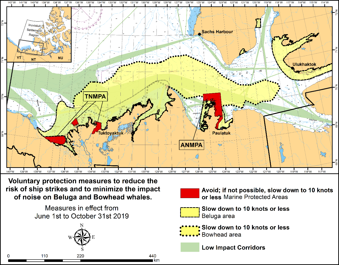
The two established Marine Protected Areas (MPAs) in Canada’s Western Arctic are located within the Inuvialuit Settlement Region, as such all activities must comply with the Inuvialuit Final Agreement. Protection and preservation of Arctic wildlife, the environment and biological productivity is one of the principles of the Inuvialuit Final Agreement and it is this principle that led the Inuvialuit Regional Corporation and the Inuvialuit Game Council to initiate establishment of the Western Arctic MPAs. The waters in and near the MPAs, and the offshore marine habitats of the Beaufort Sea and Amundsen Gulf, are important summer foraging habitats used seasonally (May-October) by the Eastern Beaufort Sea beluga stock, and the Bering-Chukchi-Beaufort bowhead population.
REGULATORY PROTECTION MEASURES
All whale species are protected under the Marine Mammal Regulations, pursuant to the Fisheries Act. Within the boundaries of the MPAs, a general prohibition is set out in the Regulations, pursuant to the Oceans Act. Any incident with a marine mammal within the MPAs must be reported within two hours after its occurrence, to the Canadian Coast Guard. For marine wildlife sightings and incidents such as collisions that occur outside the MPAs or for any situation involving a marine mammal that is dead or in trouble, contact Fisheries and Oceans Canada, Inuvik office at (867) 777-7500.
For more information on the ANMPA and TNMPA, including local
contacts and species specific minimum distances, see Section
A2 - Notices 5 and 5A.3 of the Notices to Mariners Annual
Edition 2019.
VOLUNTARY PROTECTION MEASURES
Voluntary measures are in effect from June 1st to October 31st, 2019. See map above.
These measures apply to merchant vessels, cruise ships, small vessels and adventure craft within the boundaries of the MPAs and the additional identified areas to prevent collisions with whales and to mitigate the underwater noise generated by the vessels. These measures should only be taken when they will not jeopardize navigational safety.
Avoid (red area): To reduce the risk of underwater noise disturbance and collisions with whales within the MPAs, vessels should avoid transiting through the MPAs if possible. If passage through this area is required, vessels should slow down to a maximum speed through the water of 10 knots and post a lookout such as a marine mammal observer in order to increase the chances of seeing the whales and thus taking necessary measures to avoid them. If bypassing the whales is not possible, slow down and wait for the animals to move away to a distance greater than 400 metres (0.215 nautical miles) before resuming original speed up to 10 knots. It is more difficult to see the animals in rain, fog, or in rough sea states, therefore increased caution is recommended.
Slow down to 10 knots or less (yellow area): To reduce the risk of underwater noise disturbance and collisions with whales within this area, it is recommended that vessels should slow down to a maximum speed through the water of 10 knots, remain in the navigation and marked community supply channels and post a lookout.
These voluntary measures are secondary to rights under the Inuvialuit Final Agreement.
MPA Coordinates
The Tarium Niryutait Marine Protected Areas consist of three areas of the Mackenzie Bay: Okeevik, Kittigaryuit and Niaqunnaq. The three areas are bounded by rhumb lines connecting the following geographical coordinates [North America Datum 1983 (NAD 83)/World Geodetic System (WGS 84)].
Okeevik Sub Area
|
Point |
Latitude (North) |
Longitude (West) |
|
1 |
69° 38’ 19” |
135° 25’ 09” |
|
2 |
69° 38’ 03” |
135° 25’ 11” |
|
3 |
69° 37’ 46” |
135° 24’ 52” |
|
4 |
69° 29’ 49” |
135° 12’ 49” |
|
5 |
69° 30’ 45” |
135° 16’ 56” |
|
6 |
69° 29’ 26” |
135° 18’ 53” |
|
7 |
69° 29’ 23” |
135° 19’ 06” |
|
8 |
69° 28’ 07” |
135° 20’ 25” |
|
9 |
69° 27’ 36” |
135° 24’ 25” |
|
10 |
69° 25' 51” |
135° 32’ 27” |
|
11 |
69° 26’ 32” |
135° 34’ 54” |
|
12 |
69° 28’ 21” |
135° 35’ 24” |
|
13 |
69° 28’ 35” |
135° 36’ 40” |
|
14 |
69° 28’ 39” |
135° 37’ 58” |
|
15 |
69° 30’ 34” |
135° 45’ 54” |
|
16 |
69° 35’ 18” |
135° 35’ 42” |
|
17 |
69° 36’ 00” |
135° 22’ 10” |
|
18 |
69° 34’ 40” |
135° 20’ 09” |
|
19 |
69° 34’ 00” |
135° 20’ 09” |
|
20 |
69° 34’ 00” |
135° 27’ 39” |
|
21 |
69° 36’ 00” |
135° 27’ 39” |
|
22 |
69° 27’ 00” |
135° 31’ 11” |
|
23 |
69° 27’ 00” |
135° 34’ 45” |
Kittigaryuit Sub Area
|
Point |
Latitude (North) |
Longitude (West) |
|
1 |
69° 35’ 10” |
133° 48’ 26” |
|
2 |
69° 34’ 00” |
133° 28’ 00” |
|
3 |
69° 23’ 37” |
133° 26’ 40” |
|
4 |
69° 20’ 34” |
133° 40’ 37” |
|
5 |
69° 19’ 05” |
133° 42’ 21” |
|
6 |
69° 19’ 01” |
133° 42’ 31” |
|
7 |
69° 20’ 39” |
133° 43’ 20” |
|
8 |
69° 16’ 42” |
133° 54’ 54” |
|
9 |
69° 15’ 20” |
134° 06’ 53” |
|
10 |
69° 16’ 33” |
134° 05’ 56” |
|
11 |
69° 20’ 42” |
134° 02’ 44” |
|
12 |
69° 24’ 00” |
133° 59’ 10” |
|
13 |
69° 24’ 34” |
133° 53’ 49” |
|
14 |
69° 28’ 21” |
133° 48’ 15” |
|
15 |
69° 28’ 02” |
133° 50’ 59” |
|
16 |
69° 33’ 20” |
133° 47’ 29” |
|
17 |
69° 34’ 33” |
133° 47’ 42” |
|
18 |
69° 32’ 55” |
133° 51’ 09” |
|
19 |
69° 32’ 56” |
133° 51’ 54” |
|
20 |
69° 33’ 46” |
133° 55’ 48” |
|
21 |
69° 33’ 46” |
133° 55’ 31” |
Niaqunnaq Sub Area
|
Point |
Latitude (North) |
Longitude (West) |
|
1 |
69° 08’ 00” |
136° 16’ 44” |
|
2 |
69° 04’ 25” |
136° 07’ 45” |
|
3 |
69° 03’ 43” |
136° 07’ 08” |
|
4 |
69° 01’ 19” |
136° 04’ 45” |
|
5 |
69° 01’ 14” |
136° 04’ 45” |
|
6 |
69° 00’ 57” |
136° 05’ 42” |
|
7 |
69° 00’ 12” |
136° 07’ 08” |
|
8 |
68° 57’ 00” |
136° 10’ 00” |
|
9 |
68° 55’ 00” |
136° 15’ 00” |
|
10 |
68° 54’ 22” |
136° 31’ 50” |
|
11 |
68° 55’ 00” |
136° 38’ 33” |
|
12 |
68° 56’ 15” |
137° 00’ 41” |
|
13 |
68° 56’ 29” |
137° 03’ 03” |
|
14 |
68° 55’ 48” |
137° 11’ 00” |
|
15 |
68° 57’ 50” |
137° 16’ 40” |
|
16 |
68° 59’ 20” |
137° 21’ 30” |
|
17 |
69° 03’ 09” |
137° 44’ 54” |
The Anguniaqvia
niqiqyuam Marine Protected Areas consist of two areas
in Darnley Bay and Amundsen Gulf in the Beaufort Sea: Zone 1
and Zone 2. The areas consist of the seabed, the subsoil to a
depth of five metres and the water column, including the sea
ice. The two areas are bounded by straight lines connecting
the following geographical coordinates [North America Datum
1983 (NAD 83)].
Zone 1
|
Point |
Latitude (North) |
Longitude (West) |
|
A |
69° 21’ 07.8” |
124° 21’ 32.0” approx |
|
B |
70° 12’ 00.0” approx |
124° 31’ 55.2” |
|
C |
70° 08’ 22.0” |
124° 41’ 45.0” approx |
|
D |
70° 09’ 09.9” |
124° 57’ 42.0” approx |
|
E |
70° 09’ 13.0” approx |
125° 05’ 28.6” |
|
F |
70° 09’ 13.2” |
125° 17’ 53.0” |
|
G |
70° 20’ 00.0” |
125° 17’ 53.0” |
|
H |
70° 20’ 00.0” |
123° 54’ 17.5” |
|
I |
69° 37’ 20.6” |
123° 54’ 17.5” |
|
J |
69° 30’ 00.0” |
124° 15’ 34.7” |
Zone 2
|
Point |
Latitude (North) |
Longitude (West) |
|
K |
70° 04’ 15.8” |
124° 41’ 51.0” approx |
|
L |
70° 04’ 48.6” |
124° 41’ 54.0” approx |
|
M |
70° 02’ 12.9” |
124° 35’ 23.0” approx |
|
N |
70° 02’ 12.9” |
124° 35’ 29.0” approx |
*815(P)HOWE SOUND – DAYBEACON TO BE DISCONTINUED
Reference Chart: 3526
The Canadian Coast Guard proposes to permanently discontinue the following aid to navigation:
| White Cliff Point port daybeacon | (LL 5276.5) | (49° 22’ 18.0”N 123° 17’ 37.5”W) |
Comments on this action are solicited from mariners and other interested parties by November 29, 2019, three months following the initial publication date of August 30, 2019. Following this date, this notice will be cancelled. Comments should be directed to the following:
A/Superintendent, Glenna Evans
Aids to Navigation & Waterways, Western Region
Canadian Coast Guard
25 Huron Street
Victoria, BC V8V 4V9
Telephone: (250) 480-2602
Fax: (250) 480-2702
Email: glenna.evans@dfo-mpo.gc.ca
Any objections raised must state the facts on which they are based and should include supporting information on safety, commerce and public benefit.
(P2019-099)
*1001CANADIAN COAST GUARD - LIST OF CHARTS AND REFERENCE CHARTS (SECTION 1) AFFECTED BY TEMPORARY AND PRELIMINARY NOTICES
IN EFFECT OCTOBER 25, 2019
(REVISED AND PROMULGATED QUARTERLY)
|
2017 |
909(T)/14 709(T)/18 |
4236 |
811(P)/19 |
|
2044 |
1005(T)/15 |
4379 |
812(P)/19 |
|
2058 |
809(T)/18 |
4426 |
716(T)/19 907(P)/19 908(P)/19 |
|
2060 |
814(T)/16 |
4523 |
1003(P)/19 |
|
2067 |
1218(T)/16 |
4592 |
813(P)/19 |
|
2077 |
1011(T)/16 |
4615 |
1004(P)/19 |
|
2085 |
1205(T)/17 417(T)/19 |
4619 |
1005(P)/19 |
|
2086 |
1219(T)/16 |
4825 |
910(P)/19 |
|
2123 |
309(T)/17 |
4841 |
814(P)/19 |
|
2181 |
108(T)/17 |
4848 |
911(P)/19 |
|
2235 |
818(T)/16 |
4855 |
912(P)/19 |
|
2291 |
816(T)/19 |
4886 |
1006(P)/19 |
|
2315 |
515(T)/16 |
6022 |
1206(T)/17 |
|
3526 |
815(P)/19 |
6287 |
113(T)/17 |
*1002PLAYGREEN LAKE TO/AU LITTLE PLAYGREEN LAKE – UNLIT BUOYS REPOSITIONED
Reference Chart: 6263
The following unlit buoys have been permanently repositioned:
|
Warrens Landing spar buoy - Playgreen P3 |
(LL 9682): |
53° 54’ 24.7”N 097° 57’ 31.1”W |
|
Warrens Landing spar buoy - Playgreen P5 |
(LL 9683): |
53° 54’ 19.9”N 097° 57’ 38.4”W |
|
Warrens Landing spar buoy - Playgreen P6 |
(LL 9684): |
53° 54’ 10.1”N 097° 57’ 55.6”W |
|
Playgreen Lake spar buoy PP1 |
(LL 9747): |
53° 55’ 22.6”N 097° 56’ 43.7”W |
|
Playgreen Lake spar buoy PP5 |
(LL 9750): |
53° 54’ 03.7”N 097° 58’ 18.7”W |
(A2019-013 to 017)
SECTION 2 - CHART CORRECTIONS
3313 - Approaches to/Approches à Nanaimo - Sheet/Feuille 20 - New Edition - 02-JAN-2009 - NAD 1983
(See Chart No. 1, Qf)
to 49°12′21.9″N 123°48′52.1″W
3443 - Thetis Island to/à Nanaimo - New Edition - 20-DEC-2002 - NAD 1983
(See Chart No. 1, Qf)
to 49°12′21.9″N 123°48′52.1″W
3456 - Halibut Bank to/à Ballenas Channel - New Chart - 01-JUL-2011 - NAD 1983
(See Chart No. 1, Qf)
to 49°12′21.9″N 123°48′52.1″W
3458 - Approaches to/Approches à Nanaimo Harbour - New Edition - 10-MAR-1995 - NAD 1983
(See Chart No. 1, Qf)
to 49°12′21.9″N 123°48′52.1″W
3493 - Vancouver Harbour Western Portion/Partie Ouest - New Edition - 11-JUN-2010 - NAD 1983
(See Chart No. 1, Qm)
3496 - Approaches to/Approches à Vancouver Harbour - New Chart - 29-MAR-2019 - World Geodetic System 1984
(See Chart No. 1, Qm)
3602 - Approaches to/Approches à Juan de Fuca Strait - New Edition - 29-NOV-2002 - NAD 1983
3623 - Kyuquot Sound to/à Cape Cook - New Edition - 26-AUG-1977 - NAD 1927
(See Chart No. 1, N1.1)
50°01′58.5″N 127°22′26.4″W
50°01′58.5″N 127°22′46.9″W
and 50°01′52.4″N 127°22′46.9″W
3646 - Uchucklesit Inlet - New Edition - 30-JUN-1995 - NAD 1983
(See Chart No. 1, N1.1)
49°01′44.2″N 125°01′46.9″W
49°01′44.3″N 125°03′05.1″W
49°01′11.5″N 125°03′05.1″W
and 49°01′11.4″N 125°02′40.1″W
3646 - Ucluelet Inlet - New Edition - 30-JUN-1995 - NAD 1983
(See Chart No. 1, N1.1)
48°58′50.2″N 125°34′25.1″W
48°58′50.2″N 125°34′35.0″W
and 48°58′43.5″N 125°34′35.0″W
(See Chart No. 1, N1.1)
and 48°56′16.8″N 125°31′20.0″W
(See Chart No. 1, N1.1)
and 48°56′40.3″N 125°31′43.8″W
3647 - Port San Juan - New Edition - 31-DEC-2004 - NAD 1983
(See Chart No. 1, I10)
(See Chart No. 1, I10)
(See Chart No. 1, K11)
(See Chart No. 1, I10)
(See Chart No. 1, I10)
(See Chart No. 1, K11)
(See Chart No. 1, I10)
(See Chart No. 1, I10)
(See Chart No. 1, K11)
3668 - Alberni Inlet - New Edition - 07-APR-2000 - NAD 1983
(See Chart No. 1, N1.1)
49°01′43.2″N 125°01′46.4″W
49°01′43.7″N 125°03′16.3″W
49°01′11.2″N 125°03′16.3″W
and 49°01′10.9″N 125°02′41.6″W
3670 - Broken Group - New Edition - 21-OCT-1994 - NAD 1983
3671 - Barkley Sound - New Edition - 04-NOV-2005 - NAD 1983
(See Chart No. 1, N1.1)
48°58′50.5″N 125°34′25.3″W
48°58′50.5″N 125°34′35.1″W
and 48°58′43.8″N 125°34′35.1″W
(See Chart No. 1, N1.1)
48°48′25.9″N 125°07′01.8″W
and 48°48′26.2″N 125°07′41.3″W
(See Chart No. 1, N1.1)
48°57′11.6″N 125°26′33.9″W
48°57′11.3″N 125°26′53.9″W
48°56′45.7″N 125°26′53.2″W
and 48°56′45.6″N 125°26′41.6″W
(See Chart No. 1, N1.1)
48°56′40.4″N 125°31′20.2″W
and 48°56′40.4″N 125°32′14.0″W
(See Chart No. 1, N1.1)
49°01′43.2″N 125°01′46.4″W
49°01′43.7″N 125°03′16.3″W
49°01′11.2″N 125°03′16.3″W
and 49°01′10.9″N 125°02′41.6″W
3673 - Clayoquot Sound, Tofino Inlet to/à Millar Channel - New Chart - 01-DEC-1995 - NAD 1983
(See Chart No. 1, I10)
(See Chart No. 1, I10)
(See Chart No. 1, K11)
(See Chart No. 1, I10)
(See Chart No. 1, I10)
(See Chart No. 1, K12)
(See Chart No. 1, I10)
3677 - Kyuquot - New Chart - 20-FEB-2009 - NAD 1983
(See Chart No. 1, N1.1)
and 50°01′56.0″N 127°22′29.3″W
(See Chart No. 1, N1.1)
and 50°01′50.8″N 127°22′50.5″W
3677 - Kyuquot Sound - New Chart - 20-FEB-2009 - NAD 1983
(See Chart No. 1, N1.1)
50°01′58.6″N 127°22′29.0″W
50°01′58.6″N 127°22′50.3″W
and 50°01′51.0″N 127°22′50.3″W
3681 - Coal Harbour - New Chart - 08-JUN-1990 - NAD 1983
Download Patch - ftp://ftp.dfo-mpo.gc.ca/patches/3681_Patch_NTM20191018.pdf
3683 - Checleset Bay - New Edition - 11-JUL-2003 - NAD 1983
(See Chart No. 1, N1.1)
50°01′58.5″N 127°22′32.8″W
50°01′58.3″N 127°22′49.8″W
and 50°01′51.3″N 127°22′50.2″W
3809 - Carpenter Bay to/à Burnaby Island - New Edition - 24-AUG-1979 - NAD 1927
(See Chart No. 1, I10)
(See Chart No. 1, I10)
(See Chart No. 1, I10)
(See Chart No. 1, I10)
(See Chart No. 1, I10)
3853 - Cape St. James to/à Cumshewa Inlet and/et Tasu Sound - New Edition - 02-MAR-1990 - NAD 1927
(See Chart No. 1, I10)
(See Chart No. 1, I10)
3937 - Queens Sound - New Chart - 07-JUL-2000 - NAD 1983
Download Patch - ftp://ftp.dfo-mpo.gc.ca/patches/3937_Patch_NTM20191004.pdf
3938 - Queens Sound to/à Seaforth Channel - New Edition - 15-APR-2016 - World Geodetic System 1984
Download Patch - ftp://ftp.dfo-mpo.gc.ca/patches/3938_Patch_NTM20191004.pdf
3958 - Prince Rupert Harbour - New Edition - 13-DEC-2013 - World Geodetic System 1984
(See Chart No. 1, P40.1)
3986 - Browning Entrance - New Chart - 25-DEC-2009 - NAD 1983
(See Chart No. 1, K11)
(See Chart No. 1, I10)
3987 - Kitkatla Channel and/et Porcher Inlet - New Chart - 25-DEC-2009 - NAD 1983
(See Chart No. 1, K11)
(See Chart No. 1, K11)
(See Chart No. 1, I10)
(See Chart No. 1, I10)
7011 - Hudson Strait/Détroit D'Hudson to/à Groenland - New Edition - 02-SEP-1983 - Unknown
(See Chart No. 1, K13)
7776 - Dolphin and Union Strait - New Edition - 30-MAY-1997 - NAD 1983
(See Chart No. 1, K41)
7784 - Victoria Strait - New Chart - 03-JUL-1998 - NAD 1983
(See Chart No. 1, I10)
(See Chart No. 1, I10)
SECTION 3 - RADIO AIDS TO MARINE NAVIGATION CORRECTIONS
NO CORRECTIONS FOR THIS SECTION.
SECTION 4 - SAILING DIRECTIONS AND SMALL CRAFT GUIDE CORRECTIONS
NO CORRECTIONS FOR THIS SECTION.
SECTION 5 - LIST OF LIGHTS, BUOYS AND FOG SIGNALS CORRECTIONS
The amendments are highlighted and deletions are crossed out. For general and region-specific
information on the List of Lights, click on the following links:
Newfoundland and Labrador Coast,
Atlantic Coast,
Inland Waters and
Pacific Coast.
PACIFIC COAST
| No. | Name |
Position ----- Latitude N. Longitude W. |
Light Characteristics |
Focal Height in m. above water |
Nominal Range |
Description ----- Height in meters above ground |
Remarks ----- Fog Signals |
|||
|---|---|---|---|---|---|---|---|---|---|---|
WEST COAST, VANCOUVER ISLAND (LL 66 – 179.1) |
||||||||||
|
141 G5251 |
Forbes Island |
On S. side of island. 48 56 56.0 125 24 37.8 |
Q | R | 1s | 12.9 | 4 |
White square
tower with
red band at top. 6.5 |
Radar reflector. Year round. Chart:3670 Edn 10/19 (P19-013) |
|
|
145 G5252 |
Hand Island Passage |
On rock, NW. point
of Brabant Islands. 48 56 40.8 125 19 38.9 |
Q | W | 1s | 10.3 | 4 |
White square
skeleton tower |
Radar reflector. Year round. Chart:3670 Edn 10/19 (P19-008, 051) |
|
|
149 G5254.1 |
Prideaux Island |
48 56 34.9 125 16 14.7 |
Fl | G | 4s | 8.0 | 4 | White square tower with green band at top. |
Radar reflector. Year round. Chart:3670 Edn 10/19 (P19-007) |
|
VANCOUVER HARBOUR (LL 385.5 – 416.5) |
||||||||||
| 391 | Burrard Inlet Cautionary light buoy QD |
N. boundary of
Traffic Lane. 49 19 22.1 123 09 31.9 |
Fl | Y | 4s | ….. | ….. | Yellow, marked “QD”. |
Year
round. Chart:3493 Edn 10/19 (P19-089) |
|
CANADIAN COAST GUARD - MARINE INFORMATION REPORT AND SUGGESTION SHEET
Name of Ship or Sender:..................................................................... Date:....................................
Address of Sender:..........................................................................................................................
Street # Street Name
Town / City:.............................. Prov / State:....................... Postal Code / Zip Code: ........................
Tel / Fax / E-mail address of sender (if appropriate):............................................................................
Observation Date:............................................. Time (UTC): ...........................................................
Geographical Position:......................................................................................................................
Coordinate Position: Lat: ............................................... Long:.........................................................
Position Method: DGPS GPS with WAAS GPS Radar Other
Horizontal Datum Used: WGS 84 NAD 27 Other
Estimated Position Accuracy:............................................................................................................
Chart #:............................................................ Datum: NAD 27 NAD 83
Chart Edition:.................................................... Last Correction applied:............................................
Publications affected: (Quote edition and page number):.....................................................................
*Full details (Attach additional sheets as necessary):...........................................................................
Mariners are requested to notify the responsible authorities when new or suspected dangers to navigation are discovered, changes are observed in aids to navigation, or corrections to publications are seen to be necessary.
In the case of new or suspected dangers to navigation, it is important that all details be given in order to aid with future investigations. Items of interest include heights, depths, physical description, type of bottom and equipment method used to position the item. It is helpful to mark details on the chart, which will be promptly replaced by the Canadian Hydrographic Service.
Reports should be made to the nearest Marine Communications and Traffic Services Centre (MCTS) and should be confirmed in writing to:
Leader, Notices to Mariners
Canadian Coast Guard
Department of Fisheries and Oceans
Montréal, QC H2Y 2E7
In the case of information concerning aids to navigation or the List of Lights, Buoys and Fog Signals book.
OR
Director General, Canadian Hydrographic Service & Oceanographic Services
Department of Fisheries and Oceans
Ottawa, ON K1A 0E6
In the case of new or suspected dangers to navigation or where corrections to "Sailing Directions" appear to be necessary.
For general questions on Canadian Coast Guard programs or services, please send an e-mail to:
info@dfo-mpo.gc.ca (Please include your postal code and e-mail address).
You can access the online form on the following page: https://www.notmar.gc.ca/incident-en.php or you can use the printable pdf version : https://www.notmar.gc.ca/publications/monthly-mensuel/images/monthly-form-en.pdf