
Archived information
The Standard on Web Usability replaces this content. This content is archived because Common Look and Feel 2.0 Standards have been rescinded.
Archived information is provided for reference, research or recordkeeping purposes. It is not subject to the Government of Canada Web Standards and has not been altered or updated since it was archived.
NOTICES TO MARINERS
PUBLICATION
EASTERN EDITION
June 28, 2019

Safety First, Service Always
Published Monthly by the
CANADIAN COAST GUARD
www.notmar.gc.ca/subscribe/
CONTENTS
| Section 1 | General and Safety Information |
| Section 2 | Chart Corrections |
| Section 3 | Radio Aids to Marine Navigation Corrections |
| Section 4 | Sailing Directions and Small Craft Guide Corrections |
| Section 5 | List of Lights, Buoys and Fog Signals Corrections |
Canadian Coast Guard Programs
Aids to Navigation and Waterways
Fisheries and Oceans Canada
Montreal, Quebec
H2Y 2E7
© Her Majesty the Queen in Right of Canada, 2019
DFO/2019-2028
Fs152-6E-PDF
ISSN 1719-7708
Disponible en français :
Publication des Avis aux navigateurs
Édition de l'Est
Édition mensuelle Nº06/2019
Fisheries and Oceans Canada
Official Publication of the Canadian Coast Guard
DFO/2019-2028
EXPLANATORY NOTES
Geographical positions refer directly to the graduations of the largest scale Canadian Hydrographic chart unless otherwise indicated.
Bearings refer to the true compass and are measured clockwise from 000° (North) clockwise to 359°; those relating to lights are from seaward.
Visibility of lights is that in clear weather.
Depths - The units used for soundings (metres, fathoms or feet) are stated in the title of each chart.
Elevations are normally given above Higher High Water, Large Tide unless otherwise indicated.
Distances may be calculated as follows:
1 nautical mile = 1,852 metres (6,076.1 feet)
1 statute mile = 1,609.3 metres (5,280 feet)
1 metre = 3.28 feet
Temporary & Preliminary Notices are indicated by a (T) or a (P) in Section 1, respectively. Please note that Nautical charts are not amended by the Canadian Hydrographic Service for Temporary (T) and Preliminary (P) Notices. It is recommended that mariners chart these corrections in pencil. The list of charts affected by Temporary and Preliminary Notices are revised and promulgated quarterly in Section 1 of the Monthly Edition.
Please note that, in addition to the temporary and preliminary changes normally advertised as (T) and (P) Notices, there are a few permanent changes to aids to navigation that have been advertised as Preliminary Notices to Mariners while charts are being updated for new editions.
Marine Information Report & Suggestion Sheet
Mariners are requested to notify the responsible authorities when new or suspected dangers to navigation are discovered, changes observed in aids to navigation or corrections to publications are seen
to be necessary. Such communications can be made using the Marine Information Report & Suggestion Sheet inserted on the last
page of each monthly edition of Notices to Mariners.
Canadian Hydrographic Service - Information Published in Section 2 of Notices to Mariners
Mariners are advised that only the most critical changes that directly affect safety to navigation are issued in Section 2 – Chart Corrections. This limitation
is required to ensure that charts remain as clear and easy to read as possible. As a result, mariners may see minor discrepancies of a
non-critical nature between information in official publications. For example, a small change in the nominal range or focal height of a light
may not result in the production of a chart correction in Notices to Mariners, but may result in a correction in the List of Lights, Buoys and
Fog Signals publication.
In case of discrepancy between information provided on CHS charts relating to aids to navigation, and the List of Lights, Buoys and Fog Signals publication, the latter shall be deemed as containing the most up-to-date information.
Canadian Nautical Charts & Publications
A source list of Canadian nautical charts and publications is published in Notice No. 14 of the Notices to Mariners Annual Edition 2019. The source supply and the prices
effective at the time of printing are listed. For current chart edition dates, please refer to the following website:
www.chs-shc.gc.ca/charts-cartes/paper-papier/index-eng.asp
CHART CORRECTIONS - SECTION 2
Corrections to nautical charts will be listed in numerical order by chart number. Each chart correction listed applies only to that particular chart. Related charts, if any, will have their own specific correction listed separately.
Users should also refer to CHS Chart 1: Symbols, Abbreviations and Terms for additional information pertaining to the correction of charts.
The illustration below describes the elements that will comprise a typical Section 2 chart correction:

The last correction number is identified with the LNM/D or Last Notice to Mariners Number / Date.
NOTICES TO MARINERS WEBSITE – MONTHLY EDITIONS, CHART CORRECTIONS, AND CHART PATCHES
The Notices to Mariners website allows users to access the monthly publications,
chart corrections, and chart patches.
Users can subscribe for free to the email notification service
to receive notifications when charts of interest are updated, including their patches, as well as when a new monthly edition becomes available online.
In addition, the monthly publication and related files to download, such as chart patches and Sailing Directions diagrams, can be obtained all together through the download of a single ZIP file.
ADVISORY NAVIGATIONAL WARNINGS / NOTICES TO SHIPPING
The Canadian Coast Guard is implementing a number of changes to the aids to navigation system in Canada.
These changes are advertised as Navigational Warnings, formerly called Notices to ShippingFootnote 1, that are broadcast by the Canadian Coast Guard, and are then followed up with Notices to Mariners, then charts are updated by hand correction, reprints or new editions.
Mariners are advised that all relevant Navigational Warnings (NAVWARNs) should be kept until superseded by Notices to Mariners or through revised charts issued by the Canadian Hydrographic Service (CHS).
Navigational Warnings are accessible on the applicable regional page on the Canadian Coast Guard e-Navigation Maritime Information Portal at http://www.marinfo.gc.ca/e-nav.
The Canadian Hydrographic Service is reviewing the impact of these changes with the Canadian Coast Guard and together are preparing an action plan on the issuing of chart revisions.
For further information, contact your regional Navigational Warning (NAVWARN) Issuing Desk.
Atlantic Region
* Port aux Basques MCTS Centre
Canadian Coast Guard
49 Stadium Rd.
P.O. Box 99
Port aux Basques, NL A0M 1C0
Telephone: (709) 695-2168 or 1-800-563-9089
Facsimile: (709) 695-7784
Email: NAVWARN.MCTSPortAuxBasques@innav.gc.ca
Website: http://www.marinfo.gc.ca/e-nav
Central & Arctic Region
* Prescott MCTS Centre
Canadian Coast Guard
401 King Street West
P.O. Box 1000
Prescott, ON K0E 1T0
“C” and “Q” Series
Telephone: (613) 925-0666
Facsimile: (613) 925-4519
Email: NAVWARN.MCTSPrescott@innav.gc.ca
Website: http://www.marinfo.gc.ca/e-nav
* Sydney MCTS Centre
Canadian Coast Guard
1190 Westmount Road
Sydney, NS B1R 2J6
Telephone: (902) 564-7751 or 1-800-686-8676
Facsimile: (902) 564-7662
Email: NAVWARN.MCTSSydney@innav.gc.ca
Website: http://www.marinfo.gc.ca/e-nav
* Iqaluit MCTS Centre
Operational from approximately mid-May until late December.
Canadian Coast Guard
P.O. Box 189
Iqaluit, NU X0A 0H0
“A” Series
Telephone: (867) 979-5269
“H” Series
Telephone: (867) 979-0310
Facsimile: (867) 979-4264
Email: NAVWARN.MCTSIqaluit@innav.gc.ca
Website: http://www.marinfo.gc.ca/e-nav
* Service available in English and French.
Index
NUMERICAL INDEX OF CANADIAN CHARTS AFFECTED
| 1201 | 2025 | 4367 | 4839 |
| 1220 | 2110 | 4386 | 4847 |
| 1221 | 3535 | 4405 | 4858 |
| 1236 | 3794 | 4455 | 4863 |
| 1310 | 4013 | 4460 | 4885 |
| 1311 | 4023 | 4466 | 4905 |
| 1314 | 4201 | 4474 | 4913 |
| 1315 | 4203 | 4483 | 4921 |
| 1350 | 4235 | 4485 | 4950 |
| 1430 | 4236 | 4497 | |
| 2023 | 4302 | 4622 |
SECTION 1 - GENERAL AND SAFETY INFORMATION
TRANSPORT CANADA – RESTRICTED SPEED AREA - ST. CLAIR AND DETROIT RIVERS
Since November 14, 2012, the restricted speed area currently in place as per the St. Clair and Detroit River Navigation Safety Regulations between the Detroit River light and Peche Island light is reduced in size by relocating the southern point of the restricted speed area from its current location at the Detroit River light to a new location at Bar Point light D33. (This notice refers to the previous one published in November 2012 with number *1103.)
GULF OF ST. LAWRENCE – PROTECTION OF THE NORTH ATLANTIC RIGHT WHALE
Due to the changing migratory habits of the North Atlantic Right whale and their increased presence in the Gulf of St. Lawrence, the Government of Canada has put in place seasonal speed restrictions in specified areas. These restrictions are a combination of static zone and dynamic speed reduction sectors. (See map below.)
Description of Measures
In response to consultations with industry and based on
scientific data on North Atlantic Right Whales presence, two
changes have been made to the restriction zone this
year:
oThe southeast corner of the speed restriction zone around Les Îles-de-la-Madeleine has been removed.
oTo help reduce impacts on the marine shipping industry, vessels will be allowed, in the absence of North Atlantic Right Whales sightings, to travel at safe operational speeds in a larger area north of Anticosti Island, extending to the mainland.
Static Zone Coordinates: 47°36'N
062°00'W; 47°10'N 062°30'W; 47°10'N 065°00'W; 50°20'N
065°00'W;
50°20’N 063°00’W;
49°43’N 063°00’W and 49°04’N 062°00’W.
Within the static zone, all
vessels 20 m or more in length over all (LOA) are
instructed to proceed at a speed not exceeding 10.0 knots
over the ground.
Dynamic Sector Coordinates:
Sector A)
49°41’N 065°00’W; 49°20’N
065°00’W; 49°11’N 064°00’W; 49°22’N 064°00’W;
Sector B)
49°22’N 064°00’W; 49°11’N
064°00’W; 48°48’N 063°00’W; 49°00’N 063°00’W;
Sector C)
49°00’N 063°00’W; 48°48’N
063°00’W; 48°24’N 062°00’W; 48°35’N 062°00’W; and
Sector D)
50°16’N 064°00’W; 50°00’N
064°00’W; 49°56’N 063°00’W; 50°16’N 063°00’W.
Within the static zone, there are four dynamic sectors: A, B, C and D. When the Government of Canada has determined that North Atlantic Right Whales do not appear to be present in these sectors, vessels may proceed at a safe operational speed when transiting within these sectors. When North Atlantic Right Whales presence has been determined inside a dynamic sector, vessels 20 m or more in length (LOA) will be notified through a Navigational Warning (NAVWARN) and are required to proceed at a speed not exceeding 10.0 knots over the ground within that sector.
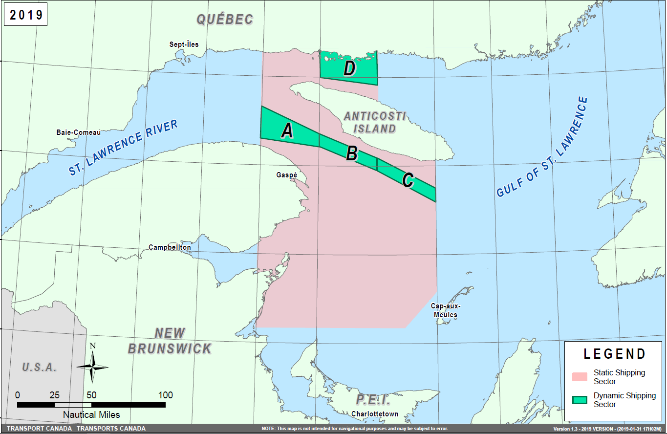
Speed restrictions within the dynamic sectors will be in effect for 15 days, from the date of issuance, and can be extended in the event of continued North Atlantic Right Whales presence. The establishment of speed restriction zones and sectors will be announced through Navigational Warnings.
These restrictions are in effect from April 28 to November 15, 2019. During this period, vessels 20 m or more in length (LOA) shall reduce speed to not exceeding 10.0 knots over the ground in the presence of North Atlantic Right Whales. These dates are subject to change dependent on their presence. Outside of the restriction period, once the mandatory speed restriction has been lifted, vessels are asked to voluntarily reduce their speed to not exceeding 10.0 knots over the ground in the presence of North Atlantic Right Whales, only if maritime conditions permit safe operation of their vessel at that speed.
Navigational Warnings (NAVWARNs) Broadcasts
The Canadian Coast Guard (CCG) continues to promulgate valid Navigational Warnings via radio broadcasts over various terrestrial systems and also online at http://www.marinfo.gc.ca/e-nav or http://nis.ccg-gcc.gc.ca. Mariners shall ensure that they have correct and up-to-date information concerning the protection of the North Atlantic Right Whales as contained in all applicable Notices to Mariners (NOTMARs) and Navigational Warnings.
Canada has replaced its Notice to Shipping (NOTSHIP) with Navigational Warnings (NAVWARNs). NOTSHIPs are no longer being issued. Mariners and other users will be able to search for NAVWARNs, or subscribe to receive NAVWARNs by email, by visiting the following web page: http://nis.ccg-gcc.gc.ca/public/rest/messages/en/search.
Until updates are completed to Canadian nautical charts and publications, Notice to Shipping or NOTSHIPs will continue to be referenced. All references to Notices to Shipping and to NOTSHIPs must be read as meaning Navigational Warnings or NAVWARNs.
Notices to Mariners (NOTMARs) will still be issued as usual and can be searched by visiting the following web page: https://www.notmar.gc.ca/monthly-mensuel-en.php.
Aids to Navigation
In addition, CCG continues to test the use of virtual Automatic Identification System aids to navigation (AIS AtoN), referred in NOTMAR 819(T)/2016. These aids will notify a mariner of a dynamic sector that is subject to a speed restriction. Each dynamic sector will be delimited by four virtual AIS AtoN which could be displayed on the ship’s navigation equipment such as: ECDIS, ECS, RADAR, Minimum Keyboard Display, and Electronic Nautical Charts. The virtual AIS AtoN will be broadcasted only when a speed restriction is in effect in one or more sectors. The mariner is required to select the virtual AIS AtoN symbol to view a message as such: “SectA1 Spd Lim 10 kt.” This message refers to a speed restriction in effect for a specific sector. As this system continues to be in the testing phase, it is not the primary means of communicating with the mariner.
Compliance and Enforcement
Navigational Warnings shall be construed as Notices to Shipping, which must be complied with under section 7 of the Collision Regulations. Failure to comply with any instructions and directions contained in Navigational Warnings could lead to either administrative monetary penalties ranging from Can$6,000 to Can$25,000, or penal sanctions under the Canada Shipping Act, 2001.
If vessels appear to have violated the speed restriction, Transport Canada Marine Safety Inspectors will review all information provided through AIS and seek information from the master. Exemptions to the speed restrictions will not be granted in advance; however, factors such as navigation to ensure vessel safety, weather conditions, force majeure (unforeseen circumstances) and responding to emergencies, will be reviewed and considered by Transport Canada.
Reporting of Whale Sightings
If you see a North Atlantic Right Whale that is entangled, dead, or injured, please report it to your nearest Canadian Coast Guard Marine Communications and Traffic Services Centre, or as follows:
•For the southern part of the Gulf of St. Lawrence:
–Marine Animal Response Society at 1-866-567-6277
•For Newfoundland and Labrador:
–Whale Release and Strandings at 1-709-895-3003
•For the Québec sector:
–Marine Mammal emergencies at 1-877-722-5346
Sightings of live, free-swimming whales should be reported by phone to 1-902-440-8611 (local) or 1-844-800-8568 (toll free) or by email at xmarwhalesightings@dfo-mpo.gc.ca.
SAGUENAY–ST. LAWRENCE MARINE PARK AND SURROUNDING WATERS – WHALE PROTECTION
The waters in and around the Saguenay–St. Lawrence Marine Park are well known for the resident endangered beluga population and the wide diversity of whales that migrate there to feed, particularly between April and November.
REGULATORY PROTECTION MEASURES
All whale species that are found in the St. Lawrence are protected under the Marine Mammal Regulations, pursuant to the Fisheries Act. Within the boundaries of the Marine Park, specific measures are set out in the Marine Activities in the Saguenay–St. Lawrence Marine Park Regulations, pursuant to the establishment of the Saguenay–St. Lawrence Marine Park Act. Any collision with a marine mammal within the Marine Park must immediately be reported to a park warden at 1-866-508-9888. For collisions that occur outside the Marine Park or for any situation involving a marine mammal that is dead or in trouble, contact the emergency network at 1-877-722-5346 or on VHF channel 16.
For more information on the Saguenay–St. Lawrence Marine Park, see notice 5C of the Notices to Mariners Annual Edition 2019.
VOLUNTARY PROTECTION MEASURES
Provisional measures in effect from May 1 to October 31, 2019. See map at the end of this notice.
These measures apply to merchant vessels and cruise ships between Pointe à Boisvert and Cap de la Tête au Chien to prevent collisions with whales. These measures should only be taken when they will not jeopardize navigational safety.
Caution area (yellow area): To reduce the risk of collisions with whales that can be present anywhere in this area, heightened vigilance of navigators is critical. Posting a lookout is recommended in order to increase the chances of seeing the whales and thus taking necessary measures to avoid them. If bypassing the whales is not possible, slow down and wait for the animals to move away to a distance greater than 400 metres (0.215 nautical miles) before resuming original speed. It is more difficult to see the animals at night therefore increased caution is recommended.
Slow down to 10 knots or less area (red area): To reduce the risk of collisions with whales in this feeding area, it is recommended that vessels slow down to a maximum speed through the water of 10 knots and post a lookout. It is further recommended to remain in the Laurentian Channel to the north of Île Rouge to minimize the impact of noise in a sensitive area south of this island, which is highly frequented by herds of beluga whales composed of females and young.
Area to be avoided (hatched red area): To reduce noise and the risk of collisions with whales, vessels should avoid transiting through this area which is highly frequented by blue whales, an endangered species. If the area cannot be avoided, slow down to a speed through the water of 10 knots or less.

SAGUENAY–ST. LAWRENCE MARINE PARK – BELUGA WHALE PROTECTION: SLOWDOWN AREA AT THE MOUTH OF THE SAGUENAY FJORD AND AREA CLOSURE AT BAIE SAINTE-MARGUERITE
The Saguenay–St. Lawrence Marine Park and its surrounding area are at the heart of endangered beluga whale critical summer habitat. Marine mammal protection measures have been put in place in accordance with the Marine Activities in the Saguenay–St. Lawrence Marine Park Regulations within the limits of the Marine Park.
However, important feeding, calving and rearing areas for beluga whales require greater protection to ensure the recovery of the species. The portion of the Saguenay situated between the mouth of the Fjord and Baie Sainte-Marguerite is one of the areas most used by females and their young from May to October. The mouth of the Saguenay is known as a feeding ground and Baie Sainte-Marguerite as a calving and rearing area.
In order to prevent collisions with beluga whales, a compulsory 15-knot slowdown area is in effect from May 1st to October 31st at the mouth of the Saguenay. To ensure tranquility for female belugas and their young during the critical calving period, access to Baie Sainte-Marguerite is prohibited to all vessels from June 21st to September 21st, except for special authorizations (see description below).
For safety reasons, these measures do not apply to cargo ships (see the monthly edition of Notice to Mariners from May to October for voluntary protection measures in the St. Lawrence Estuary). An enhanced vigilance is, however, recommended to all navigators between the mouth of the Saguenay Fjord and Baie Sainte-Marguerite for the protection of beluga whales.
For more information on the Saguenay–St. Lawrence Marine Park, see notice 5C of the Notices to Mariners Annual Edition 2019 or visit http://parcmarin.qc.ca/home/.
REGULATORY PROTECTION MEASURES — BELUGA WHALE
Entire Marine Park Territory:
•When beluga whales are less than half a nautical mile (926 metres) from a motorized vessel, the vessel must maintain a speed of between 5 and 10 knots.
•All vessels, including human-powered vessels (kayaks and canoes), must continue to move forward and maintain their heading.
•All vessels must maintain a minimum distance of 400 metres from beluga whales at all times.
For more information concerning the regulations, consult: http://marinepark.ca/protect/#regulations.
Mouth of the Saguenay Fjord (Figure 1) — Slowdown Area (area cross-hatched in red):
•Maximum
speed at the mouth of the Saguenay between buoys S7 and S8
and the ferry docks between
Baie-Sainte-Catherine and Tadoussac is 15 knots
from May 1st to October
31st.
Baie Sainte-Marguerite (Figure 2) — Area Closure (red area):
•From June 21st to September 21st, vessels must not enter the red area, which follows a line between Cap Nord-Ouest and Cap Sainte-Marguerite.
•Special authorizations are granted only for kayaks, canoes and recreational fishermen who must travel without stopping along a corridor within 10 metres of the shore or in shallow areas.
VOLUNTARY PROTECTION MEASURES
Baie Sainte-Marguerite sector (Figure 2) — Transit Area (area cross-hatched in yellow):
•From June 21st to September 21st, navigation in this area is recommended at a speed of between 5 and 10 knots without stopping.
The purpose of this transit area is to favour respect of the Marine Activities in the Saguenay–St. Lawrence Marine Park Regulations, since beluga whales are often present in the Baie Sainte-Marguerite sector.
INFORMATION
All incidents, including collisions with whales, must be reported without delay by dialling 1-866-508-9888. For any other situation concerning a marine mammal that is either dead or in trouble, contact the emergency network at 1-877-722-5346, or use VHF channel 16.
Figure 1

Figure 2

*601 CANADIAN HYDROGRAPHIC SERVICE – NAUTICAL CHARTS
|
CHARTS |
MAIN TITLE |
SCALE |
PUBLISHED |
CAT# |
PRICE |
|---|---|---|---|---|---|
|
New Editions |
|||||
|
1310 |
Port de Montréal |
1:15 000 |
07-JUN-2019 |
1, 3 |
20.00 |
|
1311 |
Sorel-Tracy à/to Varennes |
1:40 000 |
17-MAY-2019 |
1, 3 |
20.00 |
|
1315 |
Québec à/to Donnacona |
1:40 000 |
24-MAY-2019 |
1 |
20.00 |
|
3535 |
Plans - Malaspina Strait |
1:25 000 |
08-MAR-2019 |
2 |
20.00 |
|
3794 |
Stewart |
1:12 000 |
19-APR-2019 |
2 |
15.00 |
*602 CANADIAN HYDROGRAPHIC SERVICE – RASTER DIGITAL CHARTS (BSB V3)
|
CHARTS |
MAIN TITLE |
SCALE |
PUBLISHED |
|---|---|---|---|
|
New Editions |
|||
|
RM-1310 |
Port de Montréal |
1:15 000 |
07-JUN-2019 |
|
RM-1311 |
Sorel-Tracy à/to Varennes |
1:40 000 |
17-MAY-2019 |
|
RM-1315 |
Québec à/to Donnacona |
1:40 000 |
24-MAY-2019 |
|
RM-3535 |
Plans - Malaspina Strait |
1:25 000 |
08-MAR-2019 |
|
RM-3794 |
Stewart |
1:12 000 |
19-APR-2019 |
*603 TRANSPORT CANADA – SHIP SAFETY BULLETIN #10/2019
A new Ship Safety Bulletin has recently been posted to the Transport Canada website at www.tc.gc.ca/ssb-bsn/.
To view or download this bulletin, please click on the link below:
SSB#10/2019
– New Guidelines on Fatigue
RDIMS#15102600
Sign yourself up for e-Bulletin to receive an e-mail notice each time a new Ship Safety Bulletin is published on our website.
Contact us at marinesafety-securitemaritime@tc.gc.ca or 1-855-859-3123 (Toll Free).
*604 CANADIAN COAST GUARD PUBLICATION – AMENDMENTS TO NOTICES TO MARINERS ANNUAL EDITION 2019 - SECTION D, NOTICE 28: SEARCH AND RESCUE IN CANADIAN AND ADJACENT WATERS
Page 3:
AMEND AS FOLLOWS:
13Shore-based lifeboat stations:
(b)West Coast:
Victoria, Tofino, Bamfield, Port Hardy, Vancouver, Powell River, Campbell River, Bella Bella, Sandspit, Prince Rupert, Ganges and French Creek. Also one SAR Hovercraft is available at Sea Island, B.C.
*605 CANADIAN COAST GUARD PUBLICATION – MODIFICATIONS TO THE SECTIONS IN THE LIST OF LIGHTS, BUOYS AND FOG SIGNALS
Please note that some sections of the Inland Waters volume of the List of Lights, Buoys and Fog Signals have been modified. Please refer to the table below for a complete list of affected sections and actions taken.
|
Inland Waters Volume |
||
|---|---|---|
|
List of Lights # |
Affected Sections |
Actions Taken |
|
0.1 – 401 1193 – 1204.5 |
St. Lawrence River Seaway |
The content of multiple sections has been added to this section. |
|
78.8 - 83 |
Salaberry-de-Valleyfield |
Section deleted. Content transferred as a sub-section of section “St. Lawrence River Seaway.” |
|
142 |
Summerstown Small Craft Channel |
Section deleted. Content transferred as a sub-section of section “St. Lawrence River Seaway.” |
|
159 - 163.2 |
Cornwall Channel |
Section deleted. Content transferred as a sub-section of section “St. Lawrence River Seaway.” |
|
214.49 - 214.61 |
Long Sault Small Craft Channel |
Section deleted. Content transferred as a sub-section of section “St. Lawrence River Seaway.” |
|
353.8 - 371.6 |
St. Lawrence River – |
Section deleted. Content transferred as a sub-section of section “St. Lawrence River Seaway.” Renamed “Canadian Middle Channel.” |
|
393 - 394 395 - 401 |
Canadian Middle Channel |
Section deleted. Content transferred as a sub-section of section “St. Lawrence River Seaway.” |
|
394.2 - 394.8 |
Bateau Channel |
Section deleted. Content transferred as a sub-section of section “St. Lawrence River Seaway.” |
*606 CARAQUET HARBOUR, BAIE DE SHIPPEGAN AND / ET MISCOU HARBOUR – UNLIT BUOYS REPOSITIONED
Reference Chart: 4913
The following unlit buoys have been permanently repositioned:
Caraquet Harbour spar buoy EN7 (LL 6320.7): 47° 48’ 57.0”N 064° 54’ 21.0”W
Caraquet Harbour spar buoy EN10 (LL 6320.8): 47° 48’ 35.0”N 064° 54’ 11.6”W
(G2019-029, 030)
*607(P) BARREN ISLAND TO / À TAYLORS HEAD – FOG SIGNAL TO BE DISCONTINUED
Reference Chart: 4235
The Canadian Coast Guard proposes to permanently discontinue the fog signal on the following aid to navigation:
Beaver Island
(LL 602) (44° 49’
29.2”N 062°
20’ 16.0”W): The light and structure
to remain.
Comments on this action are solicited from mariners and other interested parties by September 27, 2019, three months following the initial publication date of June 28, 2019. Following this date, this notice will be cancelled. Comments should be directed to the following:
Superintendent, Renee
Pope
Aids to Navigation and
Waterways
Canadian Coast Guard
P.O. Box 5667
St. John’s, NL A1C 5X1
Telephone: (709)
772-2800
Email:
renee.pope@dfo-mpo.gc.ca
Any objections raised must state the facts on which they are based and should include supporting information on safety, commerce and public benefit.
(F2019-012)
*608(P) TAYLORS HEAD TO / À SHUT-IN ISLAND – NOTICE OF PROPOSED CHANGES
Reference Chart: 4236
The Canadian Coast Guard proposes to permanently change the following aids to navigation:
|
LL # |
Aid Name |
Position |
Proposed Changes |
|---|---|---|---|
|
5586.01 |
Ship Harbour buoy |
44° 46’
18.5”N |
Establish red lantern with flash
characteristics: |
|
5586.03 |
Ship Harbour buoy |
44° 46’
57.0”N |
Establish red lantern with flash
characteristics: |
|
5586.04 |
Ship Harbour buoy |
44° 47’
57.2”N |
Establish red lantern with flash
characteristics: |
|
5586.07 |
Ship Harbour buoy |
44° 48’
08.0”N |
Establish green lantern with flash
characteristics: Flash 0.3 s; eclipse 0.7 s.
|
|
5586.09 |
Ship Harbour buoy |
44° 48’
23.5”N |
Reposition to 44° 48’ 24.1”N 062° 51’ 36.0”W. |
Comments on this action are solicited from mariners and other interested parties by September 27, 2019, three months following the initial publication date of June 28, 2019. Following this date, this notice will be cancelled. Comments should be directed to the following:
Superintendent, Renee
Pope
Aids to Navigation and
Waterways
Canadian Coast Guard
P.O. Box 5667
St. John’s, NL A1C 5X1
Telephone: (709)
772-2800
Email:
renee.pope@dfo-mpo.gc.ca
Any objections raised must state the facts on which they are based and should include supporting information on safety, commerce and public benefit.
(F2019-013)
*609(P) ST. MARGARET'S BAY – NOTICE OF PROPOSED CHANGES
Reference Chart: 4386
The Canadian Coast Guard proposes to permanently change the following aid to navigation:
|
LL # |
Aid Name |
Position |
Proposed Changes |
|---|---|---|---|
|
488 |
Dover |
44° 29’
24.3”N |
Change the function of the aid to Port Bifurcation and the flash characteristics to Fl(2+1) 6s. The aid will maintain a port bifurcation daymark. |
Comments on this action are solicited from mariners and other interested parties by September 27, 2019, three months following the initial publication date of June 28, 2019. Following this date, this notice will be cancelled. Comments should be directed to the following:
Superintendent, Renee
Pope
Aids to Navigation and
Waterways
Canadian Coast Guard
P.O. Box 5667
St. John’s, NL A1C 5X1
Telephone: (709)
772-2800
Email:
renee.pope@dfo-mpo.gc.ca
Any objections raised must state the facts on which they are based and should include supporting information on safety, commerce and public benefit.
(F2019-011)
*610(P) BAIE WASHTAWOUKA À/TO BAIE PIASHTI – RANGE LIGHTS TO BE DISCONTINUED
Reference Chart: 4455
The Canadian Coast Guard proposes to permanently discontinue the following aids to navigation:
Aguanish range front (LL
1580) (50° 13’ 05.8”N
062° 05’
00.4”W)
Aguanish
range rear
(LL 1581)
(330°29’ 478.7 m from
front)
Comments on this action are solicited from mariners and other interested parties by September 27, 2019, three months following the initial publication date of June 28, 2019. Following this date, this notice will be cancelled. Comments should be directed to the following:
Superintendent,
Lise Richard
Aids to Navigation & Waterways,
Central & Arctic Region
Canadian Coast
Guard
101 boulevard
Champlain
Québec, QC G1K
7Y7
Telephone: (418)
648-7450
Email:
lise.richard@dfo-mpo.gc.ca
Any objections raised must state the facts on which they are based and should include supporting information on safety, commerce and public benefit.
(Q2019-086)
*611(P) CAPE ST MARY'S TO / À ARGENTIA HARBOUR AND / ET JUDE ISLAND – FOG SIGNAL TO BE DISCONTINUED
Reference Chart: 4622
The Canadian Coast Guard proposes to permanently discontinue the fog signal on the following aid to navigation:
Marticot Island
(LL 50) (47° 19’
36.8”N 054°
34’ 52.8”W): The light and structure
to remain.
Comments on this action are solicited from mariners and other interested parties by September 27, 2019, three months following the initial publication date of June 28, 2019. Following this date, this notice will be cancelled. Comments should be directed to the following:
Superintendent, Renee
Pope
Aids to Navigation and
Waterways
Canadian Coast Guard
P.O. Box 5667
St. John’s, NL A1C 5X1
Telephone: (709)
772-2800
Email:
renee.pope@dfo-mpo.gc.ca
Any objections raised must state the facts on which they are based and should include supporting information on safety, commerce and public benefit.
(N2019-039)
*612(P) HEAD OF / FOND DE PLACENTIA BAY – LIGHT TO BE DISCONTINUED
Reference Chart: 4839
The Canadian Coast Guard proposes to permanently discontinue the following aid to navigation:
Swift Current Wharf (LL 41)
(47° 52’ 42.8”N
054° 12’
03.0”W)
Comments on this action are solicited from mariners and other interested parties by September 27, 2019, three months following the initial publication date of June 28, 2019. Following this date, this notice will be cancelled. Comments should be directed to the following:
Superintendent, Renee
Pope
Aids to Navigation and
Waterways
Canadian Coast Guard
P.O. Box 5667
St. John’s, NL A1C 5X1
Telephone: (709)
772-2800
Email:
renee.pope@dfo-mpo.gc.ca
Any objections raised must state the facts on which they are based and should include supporting information on safety, commerce and public benefit.
(N2019-033)
*613(P) BACALHAO ISLAND TO / À BLACK ISLAND – LIGHT TO BE DISCONTINUED
Reference Chart: 4863
The Canadian Coast Guard proposes to permanently discontinue the following aid to navigation:
Comfort Cove Wharf (LL 353.9)
(49° 24’ 19.7”N
054° 51’
17.2”W)
Comments on this action are solicited from mariners and other interested parties by September 27, 2019, three months following the initial publication date of June 28, 2019. Following this date, this notice will be cancelled. Comments should be directed to the following:
Superintendent, Renee
Pope
Aids to Navigation and
Waterways
Canadian Coast Guard
P.O. Box 5667
St. John’s, NL A1C 5X1
Telephone: (709)
772-2800
Email:
renee.pope@dfo-mpo.gc.ca
Any objections raised must state the facts on which they are based and should include supporting information on safety, commerce and public benefit.
(N2019-035)
*614(P) PORT HARMON AND APPROACHES / ET LES APPROCHES – LIGHTS TO BE DISCONTINUED
Reference Chart: 4885
The Canadian Coast Guard proposes to permanently discontinue the following aids to navigation:
Port Harmon Southwest Breakwater (LL
180.12) (48° 30’ 29.3”N
058° 32’
17.0”W)
Port
Harmon Channel (LL 180.3) (48° 30’
38.5”N 058°
32’
21.9”W)
Comments on this action are solicited from mariners and other interested parties by September 27, 2019, three months following the initial publication date of June 28, 2019. Following this date, this notice will be cancelled. Comments should be directed to the following:
Superintendent, Renee
Pope
Aids to Navigation and
Waterways
Canadian Coast Guard
P.O. Box 5667
St. John’s, NL A1C 5X1
Telephone: (709)
772-2800
Email:
renee.pope@dfo-mpo.gc.ca
Any objections raised must state the facts on which they are based and should include supporting information on safety, commerce and public benefit.
(N2019-032)
SECTION 2 - CHART CORRECTIONS
1201 - Saint-Fulgence à/to Saguenay - New Chart - 07-FEB-2014 - NAD 1983
(See Chart No. 1, P16)
(See Chart No. 1, P16)
1220 - Baie des Sept-Îles - New Edition - 24-MAR-2017 - NAD 1983
(See Chart No. 1, I10)
(See Chart No. 1, I10)
(See Chart No. 1, I10)
(See Chart No. 1, I10)
(See Chart No. 1, I10)
(See Chart No. 1, I10)
(See Chart No. 1, I10)
(See Chart No. 1, I10)
(See Chart No. 1, I10)
(See Chart No. 1, I10)
(See Chart No. 1, I10)
(See Chart No. 1, I10)
(See Chart No. 1, I10)
(See Chart No. 1, I10)
(See Chart No. 1, I10)
(See Chart No. 1, I10)
(See Chart No. 1, I10)
(See Chart No. 1, I10)
(See Chart No. 1, I10)
(See Chart No. 1, I10)
(See Chart No. 1, I10)
(See Chart No. 1, I10)
(See Chart No. 1, I10)
(See Chart No. 1, I10)
(See Chart No. 1, I10)
(See Chart No. 1, I10)
Download Patch - ftp://ftp.dfo-mpo.gc.ca/patches/pa1220_3_20190509.pdf
1220 - Sept-Îles - New Edition - 24-MAR-2017 - NAD 1983
Download Patch - ftp://ftp.dfo-mpo.gc.ca/patches/pa1220_1_20190508.pdf
Download Patch - ftp://ftp.dfo-mpo.gc.ca/patches/pa1220_2_20190502.pdf
1221 - Pointe de Moisie à/to Île du Grand Caoui - New Edition - 27-FEB-2015 - NAD 1983
(See Chart No. 1, I10)
(See Chart No. 1, I10)
(See Chart No. 1, I10)
(See Chart No. 1, I10)
(See Chart No. 1, I10)
(See Chart No. 1, I10)
1236 - Forestville - New Edition - 26-OCT-2012 - NAD 1983
Download Patch - ftp://ftp.dfo-mpo.gc.ca/patches/pa1236-20190514.pdf
1236 - Pointe des Monts aux/to Escoumins - New Edition - 26-OCT-2012 - NAD 1983
(See Chart No. 1, Q58)
(See Chart No. 1, I10)
(See Chart No. 1, I10)
(See Chart No. 1, I10)
(See Chart No. 1, I10)
(See Chart No. 1, I10)
(See Chart No. 1, I10)
(See Chart No. 1, I10)
(See Chart No. 1, I10)
(See Chart No. 1, I10)
(See Chart No. 1, I10)
1236 - Port de Rimouski - New Edition - 26-OCT-2012 - NAD 1983
(See Chart No. 1, F33)
48°28′37.5″N 068°30′55.3″W
and 48°28′41.7″N 068°30′48.9″W
1236 - Rimouski - New Edition - 26-OCT-2012 - NAD 1983
(See Chart No. 1, F33)
48°28′37.5″N 068°30′55.3″W
and 48°28′41.7″N 068°30′48.9″W
1314 - Donnacona à/to Batiscan - New Edition - 15-MAR-2019 - NAD 1983
red starboard hand lighted spar buoy QR, marked Q50
(See Chart No. 1, Qf)
red starboard hand lighted spar buoy FlR, marked Q74
(See Chart No. 1, Qf)
green port hand lighted spar buoy QG, marked D31
(See Chart No. 1, Qg)
red starboard hand lighted spar buoy QR, marked D54
(See Chart No. 1, Qf)
1430 - Lac Saint-Louis - New Edition - 23-NOV-2018 - NAD 1983
Download Patch - ftp://ftp.dfo-mpo.gc.ca/patches/pa1430-20190508.pdf
2023 - Burleigh Falls to/à Buckhorn - Sheet/Feuille 2 - New Edition - 14-JUL-2006 - NAD 1983
(See Chart No. 1, Qg)
2025 - Balsam Lake to/à Bolsover (Lock/Écluse) - Sheet/Feuille 3 - New Edition - 09-MAR-2007 - NAD 1983
(See Chart No. 1, Qg)
2110 - Long Point Bay - New Edition - 23-FEB-2018 - World Geodetic System 1984
(See Chart No. 1, K41)
4013 - Halifax to / à Sydney - New Edition - 06-SEP-2002 - NAD 1983
(See Chart No. 1, I10)
(See Chart No. 1, I10)
4023 - Northumberland Strait / Détroit de Northumberland - New Edition - 27-DEC-2002 - NAD 1983
(See Chart No. 1, I10)
(See Chart No. 1, I10)
(See Chart No. 1, Qh)
to 46°33′23.1″N 064°06′38.5″W
4201 - Halifax Harbour: Bedford Basin - New Edition - 25-AUG-2017 - NAD 1983
(See Chart No. 1, Qg)
(See Chart No. 1, Qf)
4203 - Halifax Harbour: Black Point to / à Point Pleasant - New Edition - 28-DEC-2018 - NAD 1983
(See Chart No. 1, P1)
4302 - Canso Lock and Causeway / Écluse et Chaussée Surélevée de Canso - New Chart - 28-SEP-2012 - NAD 1983
(See Chart No. 1, D22, D27)
and 45°39′23.8″N 061°25′41.4″W
4302 - Strait of Canso - New Chart - 28-SEP-2012 - NAD 1983
(See Chart No. 1, D22, D27)
45°39′12.3″N 061°26′12.9″W
and 45°38′59.2″N 061°26′48.7″W
4405 - Pictou Island to / aux Tryon Shoals - New Edition - 21-FEB-2003 - NAD 1983
(See Chart No. 1, I10)
(See Chart No. 1, I10)
(See Chart No. 1, I10)
(See Chart No. 1, I10)
(See Chart No. 1, I10)
(See Chart No. 1, I10)
(See Chart No. 1, I10)
4460 - Charlottetown Harbour - New Edition - 09-DEC-2005 - NAD 1983
(See Chart No. 1, I10)
(See Chart No. 1, I10)
(See Chart No. 1, I10)
(See Chart No. 1, I10)
(See Chart No. 1, I10)
4466 - Hillsborough Bay - New Edition - 21-MAR-2003 - NAD 1983
(See Chart No. 1, I10)
(See Chart No. 1, I10)
(See Chart No. 1, I10)
(See Chart No. 1, I10)
(See Chart No. 1, I10)
(See Chart No. 1, I10)
(See Chart No. 1, I10)
4474 - Îles Bun à/to Baie des Moutons - New Edition - 28-MAY-1999 - NAD 1983
(See Chart No. 1, I10)
(See Chart No. 1, I10)
(See Chart No. 1, I10)
(See Chart No. 1, I10)
4483 - Caribou Harbour - New Edition - 10-JAN-2003 - NAD 1983
(See Chart No. 1, I10)
4485 - Cap des Rosiers à/to Chandler - New Edition - 17-JUN-2011 - NAD 1983
(See Chart No. 1, Q58)
4497 - Amet Sound - New Edition - 27-JUN-2003 - NAD 1983
(See Chart No. 1, I10)
(See Chart No. 1, I10)
4905 - Cape Tormentine - New Edition - 29-DEC-2000 - NAD 1983
(See Chart No. 1, Qg)
to 46°08′00.8″N 063°46′33.0″W
4905 - Cape Tormentine à / to West Point - New Edition - 29-DEC-2000 - NAD 1983
(See Chart No. 1, K28, I3.1)
(See Chart No. 1, Qf)
to 46°14′00.7″N 064°22′42.7″W
(See Chart No. 1, Qf)
(See Chart No. 1, Qh)
to 46°33′23.1″N 064°06′38.5″W
4913 - Caraquet Harbour, Baie de Shippegan and / et Miscou Harbour - New Chart - 07-AUG-1992 - NAD 1983
red starboard hand lighted spar buoy QR, marked EM28
(See Chart No. 1, Qf)
red starboard hand spar buoy, marked EN6
(See Chart No. 1, Qf)
4921 - Bonaventure - New Edition - 02-DEC-2016 - NAD 1983
Download Patch - ftp://ftp.dfo-mpo.gc.ca/patches/pa4921-20190513.pdf
4921 - Grande-Rivière - New Edition - 02-DEC-2016 - NAD 1983
(See Chart No. 1, Q58)
4950 - Îles de la Madeleine - New Edition - 19-JUL-2013 - NAD 1983
(See Chart No. 1, P1)
(See Chart No. 1, P1)
(See Chart No. 1, P1)
SECTION 3 - RADIO AIDS TO MARINE NAVIGATION CORRECTIONS
*616 RADIO AIDS TO MARINE NAVIGATION 2019 (ATLANTIC, ST. LAWRENCE, GREAT LAKES, LAKE WINNIPEG, ARCTIC AND PACIFIC)
PART 2 - Page 9
AMEND AS FOLLOWS:
Table 2-4 - Iqaluit MCTS/VFF – Broadcasts
|
Time UTC |
Site |
Frequency or Channel |
Contents |
|---|---|---|---|
|
01:15 |
Inuvik |
6218.6J3E |
Radiotelephony •Technical marine synopsis for Western Arctic waters (if applicable for Mackenzie River and Great Slave Lake area). •Marine forecast for Great Slave Lake (Area 180). •Marine forecast for Mackenzie River (Area 110) and Mackenzie Delta. •ODAS Weather Buoys 45141 and 45150. •Navigational Warnings (H-Series). |
|
Hay River |
4363J3E |
||
|
Parson’s Lake and Enterprise |
Ch26 |
||
|
Yellowknife |
Ch85 |
PART 2 - Page 10
AMEND AS FOLLOWS:
Table 2-4 - Iqaluit MCTS/VFF – Broadcasts
|
Time UTC |
Site |
Frequency or Channel |
Contents |
|---|---|---|---|
|
13:15 |
Inuvik |
6218.6J3E |
Radiotelephony •Technical marine synopsis for Western Arctic waters (if applicable for Mackenzie River and Great Slave Lake area). •Marine forecast for Great Slave Lake (Area 180). •Marine forecast for Mackenzie River (Area 110) and Mackenzie Delta. •ODAS Weather Buoys 45141 and 45150. •Navigational Warnings (H-Series). |
|
Hay River |
4363J3E |
||
|
Parson’s Lake and Enterprise |
Ch26 |
||
|
Yellowknife |
Ch85 |
SECTION 4 - SAILING DIRECTIONS AND SMALL CRAFT GUIDE CORRECTIONS
Chapter 1 — Paragraph 146
Delete: “Ruins of a
private … caution is
advised.”
Replace by:A concrete boat ramp lies adjacent to the east side of the inner end of the Public wharf. Another wharf face, 167 feet (51 m) long, extends east from the boat ramp. It has a depth of 11 feet (3.3 m) alongside its eastern 131-foot (40-m) length. A depth of 10 feet (3.2 m) is reported to lie about 66 feet (20 m) north of the east end of the previously mentioned wharf face.
(N2019-03.8)
Chapter 1 — Delete paragraph 168
Replace by:168 In Grevigneux Harbour there is a Public wharf with depths of 12 and 23 feet (3.8 and 6.9 m) alongside the SE and NW corners, respectively, of its outer end 26 feet (8 m) wide. Depths of less than 16 feet (5 m) lie close NE to ENE of the outer end of the wharf. A light (251) is shown from a mast on the outer end of the Public wharf. Two wharf faces extend south from the west side of the outer end of the wharf. The north face, 230 feet (70 m) long, has depths of 12 and 22 feet (3.6 and 6.8 m) alongside its SW and NE ends, respectively. The south face, 180 feet (55 m) long, has depths of 7 to 12 feet (2 to 3.6 m) alongside its northern 49-foot (15-m) section. The remainder of the south face has depths less than 7 feet (2 m) alongside. Several large buildings stand adjacent to the wharf. Fresh water and electricity are available at the Public wharf.
(N2019-03.9)
Chapter 2 — Paragraph 76
Delete: has a depth alongside of 4.9 m (16 ft).
Replace by: is protected by large stones, forming a breakwater.
(N2019-04.0)
Chapter 2 — Paragraph 118
Delete: “A 54-m (177 ft) … 2.1 m
(7 ft) alongside.”
Replace by:A 64-m (210-ft) long wharf extends south from the inner end of the pier. It has a depth of 3.5 m (11 ft) alongside.
(N2019-04.1)
Chapter 3 — Paragraph 85
Delete: 16 feet (4.8 m)
Replace by: 13 feet (3.9 m)
(N2019-04.2)
Chapter 3 — Paragraph 85
Delete: “In 2014, the Public … is
advised.”
(N2019-04.3)
Chapter 4 — Paragraph 136
Delete: 3.7 m (12 ft)
Replace by: 3.3 m (11 ft)
(N2019-04.4)
Chapter 5 — Paragraph 244, last line
Add:An 80-m (262-ft) long section has been added to the stone breakwater at Musgrave Harbour, near its inner end. The new stone section extends in an ENE direction and was constructed atop a shoal and islet 1 m (3 ft) in elevation. A light (396.75) is shown from a mast on the outer end of this new section of the breakwater.
(N2019-04.5)
Chapter 6 — Delete paragraph 59
Replace by:59 At the settlement of Valleyfield, situated on the NE side of the harbour, there is a Public wharf 220 m (722 ft) long. The NW 70-m (230-ft) section of the wharf has depths of 3.7 to 4 m (12 to 13 ft) alongside. The SE section, 150 m (492 ft) long has depths of 3.6 m (11 ft) alongside its NW end, 2.3 m (8 ft) near its centre and 4.6 m (15 ft) near its SE end. A stone breakwater extending about 60 m (197 ft) from the shore is located close NW of the NW end of the Public wharf. Fresh water, washrooms, electricity and waste oil collection are available. Submarine pipelines extend in a SW direction about 65 m (213 ft) SE of the NW corner of the wharf.
(N2019-04.6)
Chapter 6 — Paragraph 60
Delete: 142 m (466 ft)
Replace by: 155 m (509 ft)
(N2019-04.7)
Chapter 6 — Delete paragraph 294
Replace by:294 There is an L-shaped Public wharf with its main stem extending 108 m (354 ft) from the shore to an outer section 32 m (105 ft) long and 10 m (33 ft) wide. The outer 82 m (269 ft) section of the north side of the main wharf stem has depths of 2.5 to 3.9 m (8 to 13 ft) alongside. A pier extends 53 m (174 ft) from the south face of the main wharf stem; it has a depth of 2.9 m (10 ft) on its east face. A light (442.519) is shown from a mast on the outer end of the Public wharf. A fish plant is located adjacent to the inner end of the Public wharf. A slipway is located close south of the Public wharf. Fresh water, electricity and waste oil collection are available.
(N2019-04.8)
Chapter 1 — Paragraph 37
Delete: Atlantic Marine Products
Incorporated
Replace by: Barry Group Inc.
(N2019-04.9)
Chapter 1 — After paragraph 38
Insert:38.1 A wharf 50 m (164 ft) long extends south from the previously described Public wharf. At the south end of the 50 m (164 ft) long wharf, another wharf extends 88 m (289 ft) from the shore and parallel to the previously described Public wharf, 110 m (361 ft) long. It has depths of 3.4 to 3.6 m (11 to 12 ft) and 2.1 to 3.5 m (7 to 11 ft) alongside the outer 77 m (253 ft) length of its north and south faces, respectively.
(N2019-05.0)
Chapter 1 — Adjacent to paragraph 38.1, add a wharf pictograph.
(N2019-05.1)
Chapter 1 — Paragraph 188, after “seaward side of the wharf.”
Insert:The inner section of the seaward face has been encased with stones.
(N2019-05.2)
Chapter 1 — Paragraph 242
Delete: “52 m (171 ft)
long … structure’s north side.”
Replace by:extending 40 m (131 ft) from the shore with depths of 7 and 8 m (23 and 26 ft) alongside the NE and SW ends, respectively, of the outer face 86 m (282 ft) long. The inner face of the outer end 81 m (266 ft) long has depths of 6.8 and 7.8 m (22 and 26 ft) alongside its NE and SW ends, respectively.
(N2019-05.3)
Chapter 1 — Delete paragraph 305
Replace by:305 Close NE of the south breakwater there are two Public piers extending from the shore. The south pier, 130 m (427 ft) long has a depth of 4 m (13 ft) alongside. The north pier, 104 m (341 ft) long has a depth of 4.2 m (14 ft) alongside. Several floating wharves, a slipway and a boat ramp are located close south of the south pier.
(N2019-05.4)
Chapter 1 — Paragraph 306
Delete: “Depths of 3 m
(10 ft) … from east.”
Replace by:Depths of 2.8 m (9 ft) lie about 55 m (180 ft) SSE of the outer end of the wharf. Depths of 2.6 to 3 m (9 to 10 ft) lie about 90 m (295 ft) east through ESE of the outer end of the wharf.
(N2019-05.5)
Chapter 1 — Paragraph 306.1
Delete: “Another Public
wharf … previous
wharf.”
Replace by:Depths of 2.7 to 3.8 m (9 to 12 ft) lie about 80 m (262 ft) east through south of the outer end of the Public wharf.
(N2019-05.6)
Chapter 5 — Delete paragraph 15
Replace by:15 The NE breakwater-wharf 155 m (509 ft) long has an 80-m (262-ft) long section of its centre removed. Caution is advised as depths of less than 1 m (3 ft) exist in this area where the removal took place. The remaining outer end of the breakwater-wharf about 35 m (115 ft) long is in three sections. The north face of this structure is protected with stones and is foul. A light (14.81) is shown from a mast on the SW end of the remaining breakwater-wharf section. A slipway and a small boat storage area are located close SE of the remaining outer breakwater-wharf section.
(N2019-05.7)
Chapter 5 — Adjacent to paragraph 15, add a light pictograph.
(N2019-05.8)
Chapter 6 — Paragraph 42
Delete: Burin Public wharf.
Replace by:Canadian Coast Guard Inshore Search and Rescue Base located about 0.1 mile west of the south end of Simmons Island.
(N2019-05.9)
Chapter 6 — Delete paragraph 49 and adjacent pictographs
Replace by:49 The charted pier and crib close east of the fish plant have been removed. The Canadian Coast Guard Inshore Search and Rescue Base, previously described with a wharf, floating wharf and associated buildings have been constructed at the site of the charted pier and crib located close east of the fish plant.
(N2019-06.0)
Chapter 6 — After paragraph 146
Insert:146.1 A floating wharf and a boat ramp are located on the shoreline about 0.6 mile NNE of the previously described T-shaped wharf. A small islet charted close SE has been joined to the shore by a stone breakwater. Two floating wharves are moored on the NE side of the stone breakwater.
(N2019-06.1)
Chapter 1 — Paragraph 10
Delete: 5 to 7 feet (1.4 to 2 m)
Replace by: 5 to 10 feet (1.4 to 3 m)
(N2019-06.2)
Chapter 2 — Paragraph 106
Delete: 3.6 m (12 ft)
Replace by: 3.9 m (13 ft)
(N2019-06.3)
Chapter 2 — Paragraph 145
Delete: “A rock … 0.9 mile SW of Arnold
Rock.”
Replace by:A rock, at a depth of 4.7 m, lies 0.25 mile SSW of Arnold Rock; another rock, at a depth of 5.5 m, lies 0.9 mile SW of Arnold Rock.
(A2019-005.3)
Chapter 3 — Paragraph 9, after “2.5 miles south of Collies Head.”
Insert:A shoal patch, at a depth of 4.6 m, is located 0.6 mile SW of Collies Head.
(A2019-005.4)
Chapter 3 — Paragraph 85
Delete: 45 m
Replace by: 60 m
(A2019-005.5)
Chapter 3 — Paragraph 85, after “along both sides.”
Insert:A light (547.3) is shown from a mast at the north end of the wharf.
(A2019-005.6)
Chapter 3 — Adjacent to paragraph 85, add a light pictograph.
(A2019-005.7)
Chapter 2 — In the vicinity of paragraph
41
Replace the GRANDE-ENTRÉE
diagram with the new one provided in
Section 4 of this Monthly
Edition.
www.notmar.gc.ca/publications/monthly-mensuel/images/ed0619-sec4-atl108-grandeentreediagramme-20190523.pdf
(Q2019-035.1)
Chapter 2 — Paragraph 50, after “these two wharves.”
Insert:A light (1495.5) marks the outer end of the west breakwater.
(Q2019-032.1)
Chapter 2 — Adjacent to paragraph 50, add a light pictograph.
(Q2019-032.3)
Chapter 2 — In the vicinity of paragraph
50
Replace the POINTE-BASSE
diagram with the new one provided in
Section 4 of this Monthly
Edition.
www.notmar.gc.ca/publications/monthly-mensuel/images/ed0619-sec4-atl108-pointebassediagramme-20190527.pdf
(Q2019-032.2)
Chapter 2 — In the vicinity of paragraph
93
Replace the L’ANSE-À-LA-CABANE
diagram with the new one provided in
Section 4 of this Monthly
Edition.
www.notmar.gc.ca/publications/monthly-mensuel/images/ed0619-sec4-atl108-lansealacabanediagramme-20190524.pdf
(Q2019-033.1)
Chapter 2 — Paragraph 108, after “extending NW.”
Insert:A light (1491.5), shown from a mast, is on the north breakwater.
(Q2019-029.1)
Chapter 2 — Adjacent to paragraph 108, add a light pictograph.
(Q2019-029.3)
Chapter 2 — In the vicinity of paragraph
108
Replace the POINTE-AUX-LOUPS
diagram with the new one provided in
Section 4 of this Monthly
Edition.
www.notmar.gc.ca/publications/monthly-mensuel/images/ed0619-sec4-atl108-pointeauxloupsdiagramme-20190527.pdf
(Q2019-029.2)
Chapter 2 — Paragraph 112, after “south breakwater.”
Insert:A second light (1481.3) marks the outer end of the north breakwater.
(Q2019-031.1)
Chapter 2 — In the vicinity of paragraph
112
Replace the GROSSE-ÎLE-NORD
diagram with the new one provided in
Section 4 of this Monthly
Edition.
www.notmar.gc.ca/publications/monthly-mensuel/images/ed0619-sec4-atl108-grosseilenorddiagramme-20190527.pdf
(Q2019-031.2)
Chapter 3 — Paragraph 63, after “1 foot (0.3 m) between them.”
Add:A light (920.1) is shown from a skeleton tower, having a red and white daymark, on the outer end of the west breakwater.
(A2019-008.28)
Chapter 3 — Adjacent to paragraph 63, add a light pictograph.
(A2019-008.29)
Chapter 4 — Delete paragraph 235
Replace by:235 Ruisseau-Leblanc is a community situated 8 miles WNW of Pointe Bonaventure. There is a former fishing harbour which is protected by a breakwater in the east part of the harbour and by a breakwater-wharf in the south part. Silting occurs in the harbour. There is a damaged launching ramp. The breakwater-wharf is in ruins and access is prohibited.
(Q2019-040.1)
Chapter 4 — Adjacent to paragraph 235, delete the wharf pictograph.
(Q2019-040.2)
Chapter 4 — Delete paragraph 236
Replace by:236 Due to silting, mariners should contact the local users for depth information. Mariners are advised to exercise caution when navigating in the area.
(Q2019-040.3)
Chapter 2 — Paragraph 151, after “NNE of the public
wharf”
Delete: “and several floating … leading
light (1554).”
Replace by:. A second launching ramp utilizing the natural slope of the rock is in the bay NW of the public wharf. A small wharf in ruins is further west in the bay. On the other side of the bay several floating wharves are situated WNW of the rear leading light (1554).
(Q2019-024.1)
Chapter 2 — In the vicinity of paragraph
151
Replace the TÊTE-À-LA-BALEINE
diagram with the new one provided in
Section 4 of this Monthly
Edition.
www.notmar.gc.ca/publications/monthly-mensuel/images/ed0619-sec4-atl108-tetealabaleinediagramme-20190523.pdf
(Q2019-024.2)
Chapter 2 — Paragraph 153
Delete: oil tanks
Replace by: conspicuous white
tanks
(Q2019-024.3)
Chapter 3 — Paragraph 17, after “NW face.”
Insert:A concrete boat ramp is located close east of the outer end of the pier.
(N2019-06.4)
Chapter 3 — Paragraph 38
Delete: “An L-shaped … east shore of the
cove.”
Replace by:A stone breakwater extends 804 feet (245 m) from the east shore of the cove. On the south side of the breakwater near its outer end there is a Public wharf for small boats which is 75 feet (23 m) long with a depth of 3 feet (1 m) alongside. Caution is advised as depths of less than 3 feet (1 m) lie in the approach to and close south of the wharf.
(N2019-06.5)
Chapter 3 — After paragraph 71
Insert:71.1 A Public pier extends from a position about 98 feet (30 m) north of the south end of the main Public wharf. It is 302 feet (92 m) long and has depths of 14 to 16 feet (4.2 to 4.9 m) alongside.
(N2019-06.6)
Chapter 3 — Adjacent to paragraph 71.1, add a wharf pictograph.
(N2019-06.7)
Chapter 3 — Delete paragraph 72
Replace by:72 An L-shaped Public wharf at the SW end of the harbour, about 154 feet (47 m) SW of the main Public wharf, has its main stem extending 164 feet (50 m) from the shore to an outer end 98 feet (30 m) long. The north and south faces of the outer end have depths of 14 feet (4.2 and 4.4 m), respectively, alongside. A light (211.82) is shown from a mast on the outer end of the wharf.
(N2019-06.8)
Chapter 3 — Delete paragraph 118
Replace by:118 On the west shore two L-shaped breakwater-wharves form a small craft basin having an entrance about 100 feet (30 m) wide. The seaward face of both breakwater-wharves is protected by stones. Near the outer end of the north breakwater-wharf a stone breakwater extends 279 feet (85 m) in an easterly direction. A light (202.2) is shown from a mast on the outer end of the north stone breakwater. A fish plant is located adjacent to the wharf at the south end of the basin. Fresh water, gasoline and diesel fuel are available.
(N2019-06.9)
Chapter 3 — Paragraph 157
Delete: 17 to 20 feet (5.1 to
6 m)
Replace by: 13 to 15 feet (3.9 to
4.5 m)
(N2019-07.0)
Chapter 3 — Paragraph 170
Delete: 5 to 7 feet (1.5 to 2 m)
Replace by: 1 to 7 feet (0.2 to 2 m)
(N2019-07.1)
Chapter 1 — In the vicinity of paragraph 283, Table 1.3 Port of Sept-Îles Wharves
Make the following changes in the “Depth †” column.
| Berth | Depth † | |
|---|---|---|
| metres | ||
| 16 | 3.3 to 4.5 | |
| 17 | 1.1 to 2.3 | |
| 20 | 0.9 to 4.7 |
(Q2019-020.1)
Chapter 3 — In the vicinity of paragraph 197,
Table 3.5 Port of Rimouski Wharves
Make the following changes in the
“Remarks”
column.
| Berth | Remarks | |
|---|---|---|
| 1 | Wharf in ruins / Berthing is prohibited / Vessels are not to approach within 20 m of the wharf. | |
| 8 | Wharf in ruins / Berthing is prohibited / Vessels are not to approach within 20 m of the wharf. | |
| 2 | Wharf in ruins / Berthing is prohibited / Vessels are not to approach within 20 m of the wharf. |
(Q2019-037.1)
Chapter 1 — In the vicinity of paragraph
19
Replace the GRANDES-BERGERONNES
diagram with the new one provided in
Section 4 of this Monthly
Edition.
www.notmar.gc.ca/publications/monthly-mensuel/images/ed0619-sec4-atl108-grandesbergeronnesdiagramme-20190507.pdf
(Q2019-008.1)
Chapter 1 — Paragraph 108
Delete: “; there are depths of
5.3 m … 6.3 m on the east
face.”
Replace by: . Consult the chart for depth
information.
(Q2019-034.1)
Chapter 1 — Paragraph 21, last line
Add:There is also fishing gear situated at about 1.2 miles SW of Pointe à Basile.
(Q2019-036.1)
Chapter 2 — Delete paragraph 191
Replace by:191 There are two marinas in this area of the St. Lawrence River: Marina de Repentigny situated SW of Île Lebel and Marina P.A.T. situated at Montréal (Pointe-aux-Trembles), 0.7 mile SW of the overhead cables that span the river. For further information on facilities see the Appendix.
(Q2019-036.2)
Chapter 2 — Delete paragraph 198
Replace by:198 Several private ferries run between islands of Îles de Boucherville.
(Q2019-036.3)
Chapter 2 — Delete paragraph 246
Replace by:246 A seaplane landing area is located SSW of Haut-fond Longueuil, outside of the main shipping channel.
(Q2019-036.4)
Chapter 2 — Adjacent to paragraph 246, delete the anchorage pictograph.
(Q2019-036.5)
Chapter 2 — Paragraph 250
Delete: 8.1 m
Replace by: 8.3 m
(Q2019-036.6)
Chapter 3 — Paragraph 14
Delete: “Mariners may
also … lockkeepers.”
(Q2019-041.1)
INDEX — After “Pierre, Île à la, C2/P70”
Delete: Pinard, Île à, C2/P198
(Q2019-036.7)
INDEX — After “Sainte-Hélène, Port,
C2/P255”
Delete: Sainte-Marguerite, Île, C2/P198
(Q2019-036.8)
SECTION 5 - LIST OF LIGHTS, BUOYS AND FOG SIGNALS CORRECTIONS
The amendments are highlighted and deletions are crossed out. For general and region-specific
information on the List of Lights, click on the following links:
Newfoundland and Labrador Coast,
Atlantic Coast,
Inland Waters and
Pacific Coast.
NEWFOUNDLAND AND LABRADOR COAST
| No. | Name |
Position ----- Latitude N. Longitude W. |
Light Characteristics |
Focal Height in m. above water |
Nominal Range |
Description ----- Height in meters above ground |
Remarks ----- Fog Signals |
|||
|---|---|---|---|---|---|---|---|---|---|---|
BONAVISTA BAY (LL 396 – 449.5) |
||||||||||
| 419.52 | Walker’s Point light buoy JV8 |
49 07 02.8 053 36 23.1 |
Fl | R | 4s | ..... | ..... | Red spar, marked “JV8”. |
Seasonal. Chart:4858 Edn 06/19 (N18-025) |
|
CONCEPTION BAY (LL 471.7 – 498.5) |
||||||||||
| 486.65 | Mouse Rock light buoy CP2 |
47 26 54.2 053 11 35.6 |
Fl | R | 4s | ..... | ..... | Red spar, marked “CP2”. |
Seasonal. Chart:4847 Edn 06/19 (N19-018) |
|
ATLANTIC COAST
| No. | Name |
Position ----- Latitude N. Longitude W. |
Light Characteristics |
Focal Height in m. above water |
Nominal Range |
Description ----- Height in meters above ground |
Remarks ----- Fog Signals |
|||
|---|---|---|---|---|---|---|---|---|---|---|
NOVA SCOTIA, SOUTHEAST COAST (LL 327 – 684.02) |
||||||||||
| 547.3 | Eastern Passage Wharf Light |
44 36
41.3 063 29 50.1 |
Fl | Y | 4s | ….. | ….. | Pipe swing pole. |
Operates 24
h. Year round. Chart:4203 Edn 06/19 (F19-004) |
|
CAPE BRETON ISLAND, N.S. (LL 704.85 – 882.5) |
||||||||||
|
774.6 H0757.5 774.7 H0757.51 |
Lingan range |
| | | | | | | | | | |
46 13 44.6 060 02 43.5 269°49’ 30.6 m from front. |
F F |
G G |
..... ..... |
4.8 7.0 |
7 7 |
Pipe swing
pole, 3.8 Pipe swing pole, 5.6 |
Visible in line of range. Seasonal. Visible in line of range. Seasonal. Chart:4367 Edn 06/19 (G18-058, 059) |
GULF OF ST. LAWRENCE (LL 883.2 – 940.3, 1169.1 – 1426, 1477.5 – 1584) |
||||||||||
| 1308 | Caraquet Channel light buoy EM8 |
NW. side of channel. 47 49 57.8 064 48 07.0 |
Fl | R | 4s | ….. | ….. | Red spar, marked “EM8”. |
(Winter spar.) Buoy may be repositioned due to shifting channel. Seasonal (in place year round). Chart:4913 Edn 06/19 (G19-026) |
|
| 1318 | Caraquet Harbour light buoy EM28 |
SW. of Île de Caraquet. 47 48 22.0 064 54 16.7 |
Q | R | 1s | ….. | ….. | Red spar, marked “EM28”. |
(Winter spar.) Buoy may be repositioned due to shifting channel. Seasonal (in place year round). Chart:4913 Edn 06/19 (G19-027) |
|
| 1400.2 | Grande-Rivière ODAS light buoy IML-9 |
Delete from
list. Chart:4921 Edn 06/19 (Q19-081) |
||||||||
| 1481.1 | Grosse-Île-Nord light buoy YG2 |
47 37
46.8 061 30 37.1 |
Fl | R | 4s | ….. | ….. | Red, marked “YG2”. |
Seasonal. Chart:4950 Edn 06/19 (Q19-083) |
|
| 1481.2 | Grosse-Île-Nord light buoy YGR |
47 37
46.3 061 30 45.4 |
Fl | Y | 4s | ….. | ….. | Yellow, marked “YGR”. |
Seasonal. Chart:4950 Edn 06/19 (Q19-085) |
|
PRINCE EDWARD ISLAND (LL 942 – 1084.7) |
||||||||||
| 948.22 | Bay Fortune Entrance light buoy NC9 |
46 19
39.4 062 20 45.4 |
Q | G | 1s | ….. | ….. | Green, marked “NC9”. |
Seasonal. Chart:N/A Edn 06/19 (G18-051, 052) |
|
| 998.5 | Canceaux Spit light buoy C9 |
E. of spit. 46 12 37.2 063 08 06.3 |
Fl | G | 4s | ….. | ….. | Green, marked “C9”. |
Seasonal. Chart:4460 Edn 06/19 (G18-055) |
|
| 1027.45 | Egmont Bay light buoy DJ |
46 33 23.1 064 06 38.5 |
Mo(A) | W | 6s | ….. | ….. | Red and white vertical stripes, marked “DJ”. |
Seasonal. Chart:4905 Edn 06/19 (G19-039) |
|
NORTHUMBERLAND STRAIT (LL 1085 – 1165.9) |
||||||||||
| 1102.3 | Robichaud light buoy XK2 |
46 14
00.7 064 22 42.7 |
Fl | R | 4s | ….. | ….. | Red spar, marked “XK2”. |
Seasonal. Chart:4905 Edn 06/19 (G19-033) |
|
| 1102.5 | Robichaud light buoy XK6 |
N. of 46 13 37.7 064 23 01.1 |
Q | R | 1s | ….. | ….. | Red, marked “XK6”. |
Seasonal. Chart:4905 Edn 06/19 (G19-034) |
|
ST. LAWRENCE RIVER (LL 1584.5 – 1772, 1823.8 – 2185.7, 2273 – 2365.95) |
||||||||||
| 1707.1 | Mont-Joli ODAS light buoy IML-3 |
Delete from
list. Chart:1236 Edn 06/19 (Q19-076) |
||||||||
| 2005 | Barre à Boulard light buoy Q74 |
46 38 03.3 071 55 45.4 |
Fl | R | 4s | ..... | ..... | Red spar, marked “Q74”. |
Year round. Chart:1314 Edn 06/19 (Q19-071) |
|
SAGUENAY RIVER (LL 1773 – 1823.4) |
||||||||||
|
1805 H2143.3 1806 H2143.31 |
Rivière Valin range |
| | | | | | | | | | | | | |
E. of river mouth. 48 27 36.7 070 58 53.7 314°02' 1020.8 m from front. |
Iso Iso |
W W |
2s 2s |
27.4 47.9 |
11 11 |
Trapezoidal skeleton tower, fluorescent red slatwork
daymark with
black vertical stripe. Fluorescent red rectangular daymark
on W. side of structure. 26.2 Square skeleton tower, fluorescent red slatwork daymark with black vertical stripe. 9.5 |
Visible in line of range. Divergence angle of 7°. Operates 24 h. Seasonal. Visible in line of range. Operates 24 h. Seasonal. Chart:1201 Edn 06/19 (Q18-153, 154) |
RIVIÈRE RICHELIEU (LL 2190 – 2272.92) |
||||||||||
| 2245 |
Pont |
Upstream of railway bridge, S. end of approach wall. 45 32 50.7 073 12 42.1 |
Fl | G | 4s | 3.5 | 4 |
Cylindrical mast, green and white square daymark. 1.9 |
Visible 360°. Structure visible upstream only. Seasonal. Chart:1350 Edn 06/19 (Q18-004) |
|
CANADIAN COAST GUARD - MARINE INFORMATION REPORT AND SUGGESTION SHEET
Name of Ship or Sender:..................................................................... Date:....................................
Address of Sender:..........................................................................................................................
Street # Street Name
Town / City:.............................. Prov / State:....................... Postal Code / Zip Code: ........................
Tel / Fax / E-mail address of sender (if appropriate):............................................................................
Observation Date:............................................. Time (UTC): ...........................................................
Geographical Position:......................................................................................................................
Coordinate Position: Lat: ............................................... Long:.........................................................
Position Method: DGPS GPS with WAAS GPS Radar Other
Horizontal Datum Used: WGS 84 NAD 27 Other
Estimated Position Accuracy:............................................................................................................
Chart #:............................................................ Datum: NAD 27 NAD 83
Chart Edition:.................................................... Last Correction applied:............................................
Publications affected: (Quote edition and page number):.....................................................................
*Full details (Attach additional sheets as necessary):...........................................................................
Mariners are requested to notify the responsible authorities when new or suspected dangers to navigation are discovered, changes are observed in aids to navigation, or corrections to publications are seen to be necessary.
In the case of new or suspected dangers to navigation, it is important that all details be given in order to aid with future investigations. Items of interest include heights, depths, physical description, type of bottom and equipment method used to position the item. It is helpful to mark details on the chart, which will be promptly replaced by the Canadian Hydrographic Service.
Reports should be made to the nearest Marine Communications and Traffic Services Centre (MCTS) and should be confirmed in writing to:
Leader, Notices to Mariners
Canadian Coast Guard
Department of Fisheries and Oceans
Montréal, QC H2Y 2E7
In the case of information concerning aids to navigation or the List of Lights, Buoys and Fog Signals book.
OR
Director General, Canadian Hydrographic Service & Oceanographic Services
Department of Fisheries and Oceans
Ottawa, ON K1A 0E6
In the case of new or suspected dangers to navigation or where corrections to "Sailing Directions" appear to be necessary.
For general questions on Canadian Coast Guard programs or services, please send an e-mail to:
info@dfo-mpo.gc.ca (Please include your postal code and e-mail address).
You can access the online form on the following page: https://www.notmar.gc.ca/incident-en.php or you can use the printable pdf version : https://www.notmar.gc.ca/publications/monthly-mensuel/images/monthly-form-en.pdf