Archived information
The Standard on Web Usability replaces this content. This content is archived because Common Look and Feel 2.0 Standards have been rescinded.
Archived information is provided for reference, research or recordkeeping purposes. It is not subject to the Government of Canada Web Standards and has not been altered or updated since it was archived.
Notices To Mariners - Monthly Summary Of (T) And (P) Notices - March - 2018
NOTICES TO MARINERS
MONTHLY REPRINT OF TEMPORARY AND PRELIMINARY NOTICESS
IN EFFECT AS OF MARCH 23, 2018
Geographical positions refer directly to the graduations of the largest scale Canadian Hydrographic chart unless otherwise indicated.
Bearings refer to the true compass and are measured clockwise from 000°(North) clockwise to 360°; those relating to lights are from seaward.
Visibility of lights is that in clear weather.
Depths - The units used for soundings (metres, fathoms or feet) are stated in the title of each chart.
Elevations are normally given above Higher High Water, Large Tides unless otherwise indicated.
EXPLANATION OF TEMPORARY AND PRELIMINARY NOTICES
Certain Notices to Mariners appearing in the monthly editions have a (T) or (P) appended to the regular number. These letters indicate that the information contained in the notice is of a temporary or preliminary nature.
TEMPORARY NOTICES (T)
If a temporary change in conditions affecting navigation exists and if the change will be effective for a period of over three months, a (T) notice will be published. Temporary changes which are effective for periods of less than three months will not normally be published. Such information will be broadcast as Notices to Shipping by the Coast Guard base of the area concerned. (T) notices will be cancelled as necessary.
PRELIMINARY NOTICES (P)
(a) When important changes affecting navigation are to take place in the near future, a Notice to Mariners describing the change will be published so that the mariners will have advanced information on the change. Such notices will be designated (P).
(b) When a change in conditions affecting navigation has taken place but full information is not available, a (P) notice giving available information will be published. This notice will be followed by a regular notice when complete information becomes available. The regular notice will cancel the (P) notice.
(c) When a change has taken place which is too complex to describe in a written notice, a (P) notice giving general information will be published. This notice will explain that follow up action will be taken to update charts by publishing patch corrections, new editions or new charts.
ACTION REQUIRED ON RECEIPT TO (T) & (P) NOTICES
It is not customary to make permanent corrections to charts and publications from (T) and (P) notices. On receipt of such notices, the information they contain should be noted in pencil on the affected charts and/or publications.
CAUTION
Mariners are reminded that charts and publications are not corrected from (T) and (P) notices when purchased from suppliers. Reference should be made to the latest list of charts affected by Temporary and Preliminary Notices published.
INDEX OF (T) & (P) NOTICES
INDEX OF CHARTS AFFECTED BY (T) & (P)
| 1430 | 3479 | 4244 | 4591 |
| 1432 | 3624 | 4266 | 4642 |
| 2017 | 3646 | 4302 | 4644 |
| 2044 | 3671 | 4307 | 4909 |
| 2060 | 3675 | 4377 | 4911 |
| 2067 | 3676 | 4406 | 4913 |
| 2077 | 3679 | 4419 | 6022 |
| 2085 | 3681 | 4426 | 6218 |
| 2086 | 3686 | 4443 | 6242 |
| 2123 | 3890 | 4459 | 6267 |
| 2181 | 4010 | 4460 | 6287 |
| 2202 | 4116 | 4466 | 14853 (U.S.) |
| 2235 | 4117 | 4491 | |
| 2315 | 4236 | 4523 |
NOTICES SUMMARY OF (T) AND (P) NOTICES
FROM 2007 TO 2018
2007 |
|||||||||||||||||||||||||||||||||||||||||||||||||||||||||||||||||||||||
*616(T) DEMARCATION BAY TO/À PHILIPS BAY – MOBILE OFFSHORE DRILLING UNIT TEMPORARILY ESTABLISHED |
|||||||||||||||||||||||||||||||||||||||||||||||||||||||||||||||||||||||
|
The unmanned mobile
offshore drilling unit “SDC” has been temporarily
established at 69° 24’ 71’’N 138° 53’
76’’W. For information, contact Captain Connelly at 1-250-598-4513 or 1-250-744-9818 or e-mail doncon@islandnet.com |
|||||||||||||||||||||||||||||||||||||||||||||||||||||||||||||||||||||||
|
(NOTSHIP H0212/06, Sarnia, June 2007) |
|||||||||||||||||||||||||||||||||||||||||||||||||||||||||||||||||||||||
2012 |
|||||||||||||||||||||||||||||||||||||||||||||||||||||||||||||||||||||||
*613(P) DÉTROIT DE NORTHUMBERLAND / NORTHUMBERLAND STRAIT: PARTIE OUEST / WESTERN PORTION: PORTS / HARBOURS – DAYMARKS TO BE DISCONTINUED |
|||||||||||||||||||||||||||||||||||||||||||||||||||||||||||||||||||||||
|
Reference Chart: 4909 The Canadian Coast Guard intends to permanently discontinue the following aids to navigation:
Shediac Island rear daymark
(46°
15’
19.4”N
064°
32’
16.4”W) Comments on this action are solicited from mariners and other interested parties by September 29th, 2012, three months following the initial publication date of June 29th, 2012. Comments should be directed to the following:
Sandra Inglis,
A/Superintendent Any objections raised must state the facts on which they are based and should include supporting information on safety, commerce and public benefit. |
|||||||||||||||||||||||||||||||||||||||||||||||||||||||||||||||||||||||
|
(G2012-116) |
|||||||||||||||||||||||||||||||||||||||||||||||||||||||||||||||||||||||
*811(P) ENTRÉE À / ENTRANCE TO MIRAMICHI RIVER – RANGE LIGHTS TO BE DISCONTINUED |
|||||||||||||||||||||||||||||||||||||||||||||||||||||||||||||||||||||||
|
Reference: Notice 712(P)/2012 is now cancelled. Reference Chart: 4911 The Canadian Coast Guard intends to permanently discontinue the following aids to navigation:
Portage Island Channel front range light (LL
1176) (47°
07’ 47.1”N
065°
02’
17.1”W) Comments on this action are solicited from mariners and other interested parties by November 30th, 2012, three months following the initial publication date of August 31st, 2012. Comments should be directed to the following:
Sandra Inglis,
A/Superintendent Any objections raised must state the facts on which they are based and should include supporting information on safety, commerce and public benefit. |
|||||||||||||||||||||||||||||||||||||||||||||||||||||||||||||||||||||||
|
(G2012-141, 142) |
|||||||||||||||||||||||||||||||||||||||||||||||||||||||||||||||||||||||
2013 |
|||||||||||||||||||||||||||||||||||||||||||||||||||||||||||||||||||||||
*405(P) MAIN-À-DIEU PASSAGE – FOG SIGNAL TO BE DISCONTINUED |
|||||||||||||||||||||||||||||||||||||||||||||||||||||||||||||||||||||||
|
Reference Chart: 4377 The Canadian Coast Guard proposes to permanently discontinue the following aid to navigation: Moque Head Fog Signal (LL 765.4) (46° 00’ 25.4”N 059° 49’ 21.7”W) Comments on this action are solicited from mariners and other interested parties by July 26th, 2013, three months following the initial publication date of April 26th, 2013. Comments should be directed to the following:
Superintendent Any objections raised must state the facts on which they are based and should include supporting information on safety, commerce and public benefit. |
|||||||||||||||||||||||||||||||||||||||||||||||||||||||||||||||||||||||
|
(G2013-003) |
|||||||||||||||||||||||||||||||||||||||||||||||||||||||||||||||||||||||
2014 |
|||||||||||||||||||||||||||||||||||||||||||||||||||||||||||||||||||||||
*309(T) KINGSTON HARBOUR AND APPROACHES/ET LES APPROCHES – INFORMATION REGARDING MOORING AND ANCHORING |
|||||||||||||||||||||||||||||||||||||||||||||||||||||||||||||||||||||||
|
All mooring or anchoring within the public port of Kingston is prohibited outside of designated marina areas until further notice without authorization from the port official. Inquiries are to be directed to Transport Canada at (416) 952-1027. |
|||||||||||||||||||||||||||||||||||||||||||||||||||||||||||||||||||||||
*909(T) KINGSTON HARBOUR AND APPROACHES/ET LES APPROCHES – DOCK UNSERVICEABLE |
|||||||||||||||||||||||||||||||||||||||||||||||||||||||||||||||||||||||
|
Reference Chart: 2017 The Kingston psychiatric hospital dock is unserviceable and out of bounds for use as dockage until further notice. |
|||||||||||||||||||||||||||||||||||||||||||||||||||||||||||||||||||||||
|
(NOTSHIP C2409/10) |
|||||||||||||||||||||||||||||||||||||||||||||||||||||||||||||||||||||||
*1006(T) WEDGEPORT AND VICINITY / ET LES ABORDS – TEMPORARY LIGHT ESTABLISHED |
|||||||||||||||||||||||||||||||||||||||||||||||||||||||||||||||||||||||
|
Reference Chart: 4244 A temporary light has been installed at Whitehead Island (LL 295) (43° 39' 45.8”N 065° 52' 02.5”W) approx. Flash characteristics have changed to Fl 4s Ec 11s and the nominal range has been reduced from 13 to 7. This light is temporarily replacing the previous light, which however still serves as landfall. |
|||||||||||||||||||||||||||||||||||||||||||||||||||||||||||||||||||||||
|
(F2014-028) |
|||||||||||||||||||||||||||||||||||||||||||||||||||||||||||||||||||||||
2015 |
|||||||||||||||||||||||||||||||||||||||||||||||||||||||||||||||||||||||
*510(P) ENTRÉE À / ENTRANCE TO MIRAMICHI RIVER – RANGE LIGHTS TO BE DISCONTINUED |
|||||||||||||||||||||||||||||||||||||||||||||||||||||||||||||||||||||||
|
Reference Chart: 4911 The Canadian Coast Guard proposes to permanently discontinue the following Aids to navigation: Fox Island South Range lights (LL 1170.5, 1170.6) (47° 05' 14.5"N 064° 58' 42"W) approx. Comments on this action are solicited from mariners and other interested parties by August 29th, 2015, three months following the initial publication date of May 29th, 2015. Comments should be directed to the following:
Superintendent, Claire
MacLaren Any objections raised must state the facts on which they are based and should include supporting information on safety, commerce and public benefit. |
|||||||||||||||||||||||||||||||||||||||||||||||||||||||||||||||||||||||
|
(G2015-028, 029) |
|||||||||||||||||||||||||||||||||||||||||||||||||||||||||||||||||||||||
*610(P) TAYLORS HEAD TO / À SHUT-IN ISLAND – BELL TO BE REMOVED |
|||||||||||||||||||||||||||||||||||||||||||||||||||||||||||||||||||||||
|
Reference Chart: 4236 The Canadian Coast Guard proposes to permanently discontinue the following aid to navigation:
Musquodoboit Ledge light and bell buoy YV3 –
Sound to be removed (Bell) Comments on this action are solicited from mariners and other interested parties by September 26th, 2015, three months following the initial publication date of June 26th, 2015. Comments should be directed to the following:
Superintendent, Claire
MacLaren Any objections raised must state the facts on which they are based and should include supporting information on safety, commerce and public benefit. |
|||||||||||||||||||||||||||||||||||||||||||||||||||||||||||||||||||||||
|
(F2015-018) |
|||||||||||||||||||||||||||||||||||||||||||||||||||||||||||||||||||||||
*809(P) LAC SAINT-LOUIS – RANGE TO BE MODIFIED |
|||||||||||||||||||||||||||||||||||||||||||||||||||||||||||||||||||||||
|
Reference Chart: 1430 The Canadian Coast Guard proposes to permanently replace the following aids to navigation: To discontinue the Dixie range lights (LLIW 1201-1202), which operates at night only, and replace it by a sector light located at position 45° 25’ 16.04’’N 073° 44’ 45.02’’W. This new sector light would have a nominal range of 5 nautical miles.
The arcs of visibility (true bearing) would be
the following: This change would be effective in the spring of 2016. Comments on this action are solicited from mariners and other interested parties by November 28th, 2015, three months following the initial publication date of August 28th, 2015. Comments should be directed to the following:
Regional
Superintendent
Central & Arctic
Region Any objections raised must state the facts on which they are based and should include supporting information on safety, commerce and public benefit. |
|||||||||||||||||||||||||||||||||||||||||||||||||||||||||||||||||||||||
|
(Q2015-143) |
|||||||||||||||||||||||||||||||||||||||||||||||||||||||||||||||||||||||
*1005(T) PORT DALHOUSIE - EAST AND WEST PIERS – ACCESS FORBIDDEN |
|||||||||||||||||||||||||||||||||||||||||||||||||||||||||||||||||||||||
|
Reference Chart: 2044 A recent engineering investigation identified structural issues and safety concerns with both the East and West piers at Port Dalhousie. In light of the inspection findings, the Department of Fisheries and Oceans is taking action to protect the safety of the public by prohibiting vessel, vehicular, and pedestrian access to the piers. Vessels can still safely navigate the waters surrounding the piers, but will be unable to moor at the piers. The City of St. Catharines will accommodate boaters as possible at other local wharves.
Mark
Sandeman
3027 Harvester Road,
Unit 310 |
|||||||||||||||||||||||||||||||||||||||||||||||||||||||||||||||||||||||
|
(NOTSHIP C567/15) |
|||||||||||||||||||||||||||||||||||||||||||||||||||||||||||||||||||||||
*1105(T) CANADA – SAFETY OF OFFSHORE EXPLORATION AND EXPLOITATION VESSELS |
|||||||||||||||||||||||||||||||||||||||||||||||||||||||||||||||||||||||
|
Reference: Notice 410(T)/2007 is cancelled. 2015 Annual Edition of Notices to Mariners, Notice No. 20, pages A20-1 to A20-4. Mariners are advised that offshore exploration and exploitation vessels may be conducting drilling operations in the following areas:
Gulf of
St. Lawrence
Mainland
NWT
Mackenzie
Delta NWT/Beaufort Sea
Arctic
Islands of the NWT/Arctic Islands of
Nunavut
Eastern
Arctic Offshore
Davis
Strait NOTE: Mariners are advised to obtain up-to-date position reports on drilling vessels and production installations before entering an area of exploration and exploitation. This information is available by contacting, as appropriate, ECAREG CANADA, NORDREG CANADA or CVTS OFFSHORE via any Marine Communications and Traffic Services Centre (MCTS). |
|||||||||||||||||||||||||||||||||||||||||||||||||||||||||||||||||||||||
|
(NOTSHIP M2215/15) (NEB) |
|||||||||||||||||||||||||||||||||||||||||||||||||||||||||||||||||||||||
*1106(T) BAY D'ESPOIR AND/ET HERMITAGE BAY– BUOY TEMPORARILY DISCONTINUED |
|||||||||||||||||||||||||||||||||||||||||||||||||||||||||||||||||||||||
|
Reference Chart: 4644 The Blackfish Cove light buoy (LL 133.22) (47° 40' 10.0"N 055° 56' 00.2"W) is temporarily discontinued. |
|||||||||||||||||||||||||||||||||||||||||||||||||||||||||||||||||||||||
|
(N2015-044) |
|||||||||||||||||||||||||||||||||||||||||||||||||||||||||||||||||||||||
2016 |
|||||||||||||||||||||||||||||||||||||||||||||||||||||||||||||||||||||||
*204(T) KENORA, RAT PORTAGE BAY – STRUCTURE REPORTED DAMAGED |
|||||||||||||||||||||||||||||||||||||||||||||||||||||||||||||||||||||||
|
Reference Chart: 6218
The light Safety Bay (LL 1471)
(49° 45’ 34.7”N 094° 31’ 24.2”W):
401 King Street
West |
|||||||||||||||||||||||||||||||||||||||||||||||||||||||||||||||||||||||
|
(NOTSHIP C1007/14) |
|||||||||||||||||||||||||||||||||||||||||||||||||||||||||||||||||||||||
*515(T) HARBOURS ON THE EAST SHORE OF LAKE SUPERIOR/PORTS SUR LA RIVE EST DU LAC SUPÉRIEUR – BUOYS TEMPORARILY DISCONTINUED |
|||||||||||||||||||||||||||||||||||||||||||||||||||||||||||||||||||||||
|
Reference Chart: 2315
The Canadian Coast Guard has temporarily
discontinued the following aids to
navigation: |
|||||||||||||||||||||||||||||||||||||||||||||||||||||||||||||||||||||||
|
(NOTSHIP C1045) |
|||||||||||||||||||||||||||||||||||||||||||||||||||||||||||||||||||||||
*518(P) CARAQUET HARBOUR, BAIE DE SHIPPEGAN AND / ET MISCOU HARBOUR – LIGHT TO BE DISCONTINUED |
|||||||||||||||||||||||||||||||||||||||||||||||||||||||||||||||||||||||
|
Reference Chart: 4913 The Canadian Coast Guard proposes to permanently discontinue the following Aid to navigation: The light Fox Dens Gully (LL 1262.8) (47° 53’ 12.1’’N 064° 30’ 15.2W) Comments on this action are solicited from mariners and other interested parties by August 27th, 2016, three months following the initial publication date of May 27th, 2016. Comments should be directed to the following:
Superintendent Any objections raised must state the facts on which they are based and should include supporting information on safety, commerce and public benefit. |
|||||||||||||||||||||||||||||||||||||||||||||||||||||||||||||||||||||||
|
(G2016-038) |
|||||||||||||||||||||||||||||||||||||||||||||||||||||||||||||||||||||||
*814(T) MAIN DUCK ISLAND TO/À SCOTCH BONNET ISLAND – PARTIALLY SUBMERGED FIXED STEEL BARGES |
|||||||||||||||||||||||||||||||||||||||||||||||||||||||||||||||||||||||
|
Reference Chart: 2060 There are 3 partially submerged fixed steel barges in North end of West Lake (43° 57’ 02.3’’N 077° 20’ 12.8’’W), which have been reported just below the water line. Barges are marked with cautionary buoys. |
|||||||||||||||||||||||||||||||||||||||||||||||||||||||||||||||||||||||
|
(NOTSHIP C1641/14) |
|||||||||||||||||||||||||||||||||||||||||||||||||||||||||||||||||||||||
*818(T) CAPE HURD TO/À LONELY ISLAND – LIGHT CHARACTERISTICS TEMPORARILY CHANGED |
|||||||||||||||||||||||||||||||||||||||||||||||||||||||||||||||||||||||
|
Reference Chart: 2235 The light characteristics of Cove Island (LL 805) (U.S. LL 12675) have temporarily changed to flash 1 second, eclipse 9 seconds and night-time operation only. |
|||||||||||||||||||||||||||||||||||||||||||||||||||||||||||||||||||||||
*819(T) AUTOMATIC IDENTIFICATION SYSTEM (AIS) |
|||||||||||||||||||||||||||||||||||||||||||||||||||||||||||||||||||||||
AIS Application-Specific Messages (ASM) and AIS AtoNMariners are advised that the Canadian Coast Guard will perform a test of AIS Application-Specific Messages (AIS- ASM) on the Pacific Coast from the Sand Heads meteorological/hydrological station: 49°06’21’’N 123°18’12’’W, and may extend this testing to other stations in the coming months. The test will start at the end of August and consist of broadcasting meteorological/hydrological (MET/HYDRO) data through AIS binary “Message 8”. Although AIS was originally developed as a means for positive identification and tracking of ships, it includes functionalities to transmit binary messages such as MET/HYDRO information and other types of data. These additional functionalities of AIS may be useful to mariners to assist in onboard voyage planning. Ships need to be equipped with a proper Class “A” AIS device for the accurate onboard display of AIS message. The IMO mandatory carriage requirement for the Class “A” AIS displayFootnote 1is the Minimum Keyboard Display (MKD) which displays the binary data in an alphanumeric form. However, as there is no current requirement for the MKD to be capable of decoding all AIS binary messages, the display and use of the ASM information may require additional hardware and/or softwareFootnote 2 . AIS Aids to Navigation (AtoN) The International Association of Marine Aids to Navigation and Lighthouse Authorities (IALA) defines an AtoN as: ‘a device or system external to vessels that is designed and operated to enhance the safe and efficient navigation of vessels and/or vessel traffic’.Footnote 3 The primary purpose of an AIS AtoN Station is to promote and enhance safety and efficiency of navigation by one or more of the following:
The use of AIS within the marine aids to navigation service is accomplished by the broadcasting of the aids to navigation report message “Message 21”. An AIS AtoN can be implemented in three ways, Real, Synthetic, and Virtual.
As the AIS information available to mariners will be dependent on their display system, not all transmitted information may be displayed. Mariners are encouraged to install systems that provide AIS overlay on either ECDIS or Radar, or both. Of those vessels that are AIS equipped the various displays available can range from no display on some Class B units, through to the mandatory Class A MKD, and to a full ECDIS or Radar overlay. In the absence of an ECDIS or Radar overlay, mariners will not be able to fully utilize the AIS AtoN functionality. Also note that there is a variance in the information that can be displayed on ECDIS or Radar equipment by the different AIS manufacturers. The symbology that may be displayed on nautical charts, display systems and the MKD is summarised below. Nautical Charts On nautical charts AIS AtoN are indicated by a magenta circle surrounding the existing AtoN symbol and an adjacent legend stating AIS. The font will be straight for fixed AtoN and italic for floating AtoN.  A physical AIS AtoN
provided as an overlay on ECDIS, Radar or other display
systems are indicated by a diamond shape with crossed
lines at the reported position of the AtoN. A physical
AIS AtoN that is off position will use the same symbol
but in red. A virtual AIS AtoN is indicated by a dotted
line diamond shape with the crossed lines at the reported
position. A physical AIS AtoN
provided as an overlay on ECDIS, Radar or other display
systems are indicated by a diamond shape with crossed
lines at the reported position of the AtoN. A physical
AIS AtoN that is off position will use the same symbol
but in red. A virtual AIS AtoN is indicated by a dotted
line diamond shape with the crossed lines at the reported
position.
The mandatory MKD is only required to display data in alphanumeric form. Some MKD are units supplemented by a small graphical display. Exact presentation will vary but this layout below would be typical of MKD displays.
Feedback on AIS-ASM Mariners are requested to provide feedback on the AIS-ASM test bed to their applicable Regional MCTS Office. Contact information can be found in the publication Radio Aids to Marine Navigation, Part 1. |
|||||||||||||||||||||||||||||||||||||||||||||||||||||||||||||||||||||||
*1011(T) LAKE ONTARIO/LAC ONTARIO (WESTERN PORTION/PARTIE OUEST) – SILTING REPORTED |
|||||||||||||||||||||||||||||||||||||||||||||||||||||||||||||||||||||||
|
Reference Chart: 2077 Silting reported in main entrance channel to Fifty Point Marina. Centre of channel depth reported to be 1.9 metres with shallower depths on the sides. Mariners are requested to use caution in the area. |
|||||||||||||||||||||||||||||||||||||||||||||||||||||||||||||||||||||||
|
(NOTSHIP C2266/16) |
|||||||||||||||||||||||||||||||||||||||||||||||||||||||||||||||||||||||
*1116(P) CAPE COOK TO CAPE SCOTT – NOTICE OF PROPOSED CHANGES |
|||||||||||||||||||||||||||||||||||||||||||||||||||||||||||||||||||||||
|
Reference Chart: 3624 The Canadian Coast Guard proposes to permanently change the following aid to navigation:
Sea Otter Cove (LL 67) (50° 40’ 16.0’’N 128°
21’ 02.0’’W NAD27), (50° 40’ 15.3’’N 128° 21’ 07.5’’W
NAD83): Comments on this action are solicited from mariners and other interested parties by February 25th, 2017, three months following the initial publication date of November 25th, 2016. Comments should be directed to the following:
Superintendent, Kevin
Carrigan Any objections must state the facts on which they are based and should include supporting information on safety, commerce and public benefit. |
|||||||||||||||||||||||||||||||||||||||||||||||||||||||||||||||||||||||
|
(P2016-127) |
|||||||||||||||||||||||||||||||||||||||||||||||||||||||||||||||||||||||
*1118(P) NOOTKA SOUND – NOTICE OF PROPOSED CHANGES |
|||||||||||||||||||||||||||||||||||||||||||||||||||||||||||||||||||||||
|
Reference Chart: 3675 The Canadian Coast Guard proposes to permanently change the following aids to navigation:
Comments on this action are solicited from mariners and other interested parties by February 25th, 2017, three months following the initial publication date of November 25th, 2016. Comments should be directed to the following:
Superintendent, Kevin
Carrigan Any objections must state the facts on which they are based and should include supporting information on safety, commerce and public benefit. |
|||||||||||||||||||||||||||||||||||||||||||||||||||||||||||||||||||||||
|
(P2016-128) |
|||||||||||||||||||||||||||||||||||||||||||||||||||||||||||||||||||||||
*1119(P) ESPERANZA INLET – NOTICE OF PROPOSED CHANGES |
|||||||||||||||||||||||||||||||||||||||||||||||||||||||||||||||||||||||
|
Reference Chart: 3676 The Canadian Coast Guard proposes to permanently change the following aids to navigation:
Comments on this action are solicited from mariners and other interested parties by February 25th, 2017, three months following the initial publication date of November 25th, 2016. Comments should be directed to the following:
Superintendent, Kevin
Carrigan Any objections must state the facts on which they are based and should include supporting information on safety, commerce and public benefit. |
|||||||||||||||||||||||||||||||||||||||||||||||||||||||||||||||||||||||
|
(P2016-125) |
|||||||||||||||||||||||||||||||||||||||||||||||||||||||||||||||||||||||
*1121(P) QUATSINO SOUND – NOTICE OF PROPOSED CHANGES |
|||||||||||||||||||||||||||||||||||||||||||||||||||||||||||||||||||||||
|
Reference Chart: 3679 The Canadian Coast Guard proposes to permanently change the following aids to navigation:
Comments on this action are solicited from mariners and other interested parties by February 25th, 2017, three months following the initial publication date of November 25th, 2016. Comments should be directed to the following:
Superintendent, Kevin
Carrigan Any objections must state the facts on which they are based and should include supporting information on safety, commerce and public benefit. |
|||||||||||||||||||||||||||||||||||||||||||||||||||||||||||||||||||||||
|
(P2016-126) |
|||||||||||||||||||||||||||||||||||||||||||||||||||||||||||||||||||||||
*1122(P) PLANS - QUATSINO SOUND – NOTICE OF PROPOSED CHANGES |
|||||||||||||||||||||||||||||||||||||||||||||||||||||||||||||||||||||||
|
Reference Chart: 3681 The Canadian Coast Guard proposes to permanently change the following aids to navigation:
Comments on this action are solicited from mariners and other interested parties by February 25th, 2017, three months following the initial publication date of November 25th, 2016. Comments should be directed to the following:
Superintendent, Kevin
Carrigan Any objections must state the facts on which they are based and should include supporting information on safety, commerce and public benefit. |
|||||||||||||||||||||||||||||||||||||||||||||||||||||||||||||||||||||||
|
(P2016-129) |
|||||||||||||||||||||||||||||||||||||||||||||||||||||||||||||||||||||||
*1123(P) APPROACHES TO/APPROCHES À WINTER HARBOUR – LIGHT CHARACTERISTICS TO BE CHANGED |
|||||||||||||||||||||||||||||||||||||||||||||||||||||||||||||||||||||||
|
Reference Chart: 3686 The Canadian Coast Guard proposes to permanently change the following aid to navigation:
Cliffe Point (LL 68.3) (50° 27' 51.6"N 127° 56'
12.6"W NAD83): Comments on this action are solicited from mariners and other interested parties by February 25th, 2017, three months following the initial publication date of November 25th, 2016. Comments should be directed to the following:
Superintendent, Kevin
Carrigan Any objections must state the facts on which they are based and should include supporting information on safety, commerce and public benefit. |
|||||||||||||||||||||||||||||||||||||||||||||||||||||||||||||||||||||||
*1218(T) HAMILTON HARBOUR – SILTING REPORTED |
|||||||||||||||||||||||||||||||||||||||||||||||||||||||||||||||||||||||
|
Reference Chart: 2067 Silting reported along the North faces of Pier 11 and Pier 12:
Pier 11 North Face between positions
43° 16’ 31”N
079°
50’ 56”W and 43° 16’
29”N 079°
50’ 49”W,
Pier 12 North Face between positions 43° 16’ 27”N 079° 50’ 39”W and 43° 16’ 26”N 079° 50’ 33”W. Mariners are requested to use caution and reduce speed upon arrival and departure. Seaway draft will be affected when water level is less than 0.70 metres above chart datum in these areas. |
|||||||||||||||||||||||||||||||||||||||||||||||||||||||||||||||||||||||
|
(NOTSHIP C1831/13) |
|||||||||||||||||||||||||||||||||||||||||||||||||||||||||||||||||||||||
*1219(T) TORONTO TO/À HAMILTON – CONSTRUCTION OPERATIONS |
|||||||||||||||||||||||||||||||||||||||||||||||||||||||||||||||||||||||
|
Reference Chart: 2086 Construction operations taking place from November 14, 2016 until approximately 2026 at Lakeview Water Treatment Plant between Marie Curtis Park and Serson Creek. A variety of equipment will be used to expand the land mass along the shoreline. Landfill and 3 islands will be lit and marked. |
|||||||||||||||||||||||||||||||||||||||||||||||||||||||||||||||||||||||
|
(NOTSHIP C2533/16) |
|||||||||||||||||||||||||||||||||||||||||||||||||||||||||||||||||||||||
2017 |
|||||||||||||||||||||||||||||||||||||||||||||||||||||||||||||||||||||||
*107(P) LAC SAINT-FRANÇOIS/LAKE ST. FRANCIS – LIGHT BUOY TO BE DISCONTINUED |
|||||||||||||||||||||||||||||||||||||||||||||||||||||||||||||||||||||||
|
Reference Chart: 1432 The Canadian Coast Guard proposes to permanently discontinue the following aid to navigation: Highlander Shoal lighted spar buoy (LL 133.2) (45° 04’ 34.2’’N 074° 31’ 04.5’’W) Comments on this action are solicited from mariners and other interested parties by April 27th, 2017, three months following the initial publication date of January 27th, 2017. Comments should be directed to the following:
Supervisor, Gary
Greer Any objections must state the facts on which they are based and should include supporting information on safety, commerce and public benefit. |
|||||||||||||||||||||||||||||||||||||||||||||||||||||||||||||||||||||||
|
(B2016-008) |
|||||||||||||||||||||||||||||||||||||||||||||||||||||||||||||||||||||||
*108(T) HARBOURS IN LAKE ERIE/HAVRES DANS LE LAC ÉRIÉ – UNLIT BUOYS TEMPORARILY REPOSITIONED |
|||||||||||||||||||||||||||||||||||||||||||||||||||||||||||||||||||||||
|
Reference Chart: 2181 The following unlit spar buoys have been temporarily repositioned due to silting:
ES2 (LL 7169) to position 42° 39’ 10.0’’N 081°
12’ 32.0’’W The shallowest depth to 3.5M occurs between ES3 and ES4 with the deepest water off the red side of the channel. Mariners are requested to use caution in the area. |
|||||||||||||||||||||||||||||||||||||||||||||||||||||||||||||||||||||||
|
(B2017-003) |
|||||||||||||||||||||||||||||||||||||||||||||||||||||||||||||||||||||||
*109(P) PORT SEVERN TO/À PARRY SOUND – UNLIT BUOYS TO BE DISCONTINUED |
|||||||||||||||||||||||||||||||||||||||||||||||||||||||||||||||||||||||
|
Reference Chart: 2202 The Canadian Coast Guard proposes to permanently discontinue the following aids to navigation:
Comments on this action are solicited from mariners and other interested parties by April 27th, 2017, three months following the initial publication date of January 27th, 2017. Comments should be directed to the following:
Supervisor, Gary
Greer Any objections must state the facts on which they are based and should include supporting information on safety, commerce and public benefit. |
|||||||||||||||||||||||||||||||||||||||||||||||||||||||||||||||||||||||
|
(D2016-015) |
|||||||||||||||||||||||||||||||||||||||||||||||||||||||||||||||||||||||
*113(T) MINAKI TO/À KENORA – DAYBEACON REPORTED LEANING |
|||||||||||||||||||||||||||||||||||||||||||||||||||||||||||||||||||||||
|
Reference Chart: 6287 The daybeacon DB - Q64 (LL 5635) (49° 51’ 06.0’’N 094° 34’ 44.0’’W) has been reported leaning. |
|||||||||||||||||||||||||||||||||||||||||||||||||||||||||||||||||||||||
|
(D2016-016) |
|||||||||||||||||||||||||||||||||||||||||||||||||||||||||||||||||||||||
*309(T) PELEE PASSAGE TO/À LA DETROIT RIVER – LOW WATER LEVELS REPORTED |
|||||||||||||||||||||||||||||||||||||||||||||||||||||||||||||||||||||||
|
Reference Chart: 2123 Low water levels have been reported from the south end of the entrance to Sturgeon Creek Harbour northward.
Annette
Winter Canada Centre for Inland Waters (CCIW)
867 Lakeshore
Road |
|||||||||||||||||||||||||||||||||||||||||||||||||||||||||||||||||||||||
|
(NOTSHIP C58/13) |
|||||||||||||||||||||||||||||||||||||||||||||||||||||||||||||||||||||||
*608(P) BAY OF FUNDY / BAIE DE FUNDY: INNER PORTION / PARTIE INTÉRIEURE – FOG HORN TO BE DISCONTINUED |
|||||||||||||||||||||||||||||||||||||||||||||||||||||||||||||||||||||||
|
Reference Chart: 4010 The Canadian Coast Guard proposes to permanently discontinue the fog horn of the following aid to navigation: Cape d’Or (LL 167) (45° 17' 27.0"N 064° 46' 27.5"W): The light and structure will remain. Comments on this action are solicited from mariners and other interested parties by September 30th, 2017, three months following the initial publication date of June 30th, 2017. Comments should be directed to the following:
Superintendent, Renee
Pope Any objections must state the facts on which they are based and should include supporting information on safety, commerce and public benefit. |
|||||||||||||||||||||||||||||||||||||||||||||||||||||||||||||||||||||||
|
(F2017-013) |
|||||||||||||||||||||||||||||||||||||||||||||||||||||||||||||||||||||||
*617(P) APPROACHES TO/APPROCHES À SIDNEY – NOTICE OF PROPOSED CHANGES |
|||||||||||||||||||||||||||||||||||||||||||||||||||||||||||||||||||||||
|
Reference Chart: 3479 The Canadian Coast Guard proposes to permanently change the following aid to navigation:
Comments on this action are solicited from mariners and other interested parties by September 30th, 2017, three months following the initial publication date of June 30th, 2017. Comments should be directed to the following:
A/Superintendent,
Glenna Evans Any objections raised must state the facts on which they are based and should include supporting information on safety, commerce and public benefit. |
|||||||||||||||||||||||||||||||||||||||||||||||||||||||||||||||||||||||
|
(P2017-031) |
|||||||||||||||||||||||||||||||||||||||||||||||||||||||||||||||||||||||
*618(P) PLANS - BARKLEY SOUND – NOTICE OF PROPOSED CHANGES |
|||||||||||||||||||||||||||||||||||||||||||||||||||||||||||||||||||||||
|
Reference Chart: 3646 The Canadian Coast Guard proposes to permanently change the following aids to navigation:
Comments on this action are solicited from mariners and other interested parties by September 30th, 2017, three months following the initial publication date of June 30th, 2017. Comments should be directed to the following:
A/Superintendent,
Glenna Evans Any objections raised must state the facts on which they are based and should include supporting information on safety, commerce and public benefit. |
|||||||||||||||||||||||||||||||||||||||||||||||||||||||||||||||||||||||
|
(P2017-039) |
|||||||||||||||||||||||||||||||||||||||||||||||||||||||||||||||||||||||
*620(P) BARKLEY SOUND – NOTICE OF PROPOSED CHANGES |
|||||||||||||||||||||||||||||||||||||||||||||||||||||||||||||||||||||||
|
Reference Chart: 3671 The Canadian Coast Guard proposes to permanently change the following aids to navigation:
Comments on this action are solicited from mariners and other interested parties by September 30th, 2017, three months following the initial publication date of June 30th, 2017. Comments should be directed to the following:
A/Superintendent,
Glenna Evans Any objections raised must state the facts on which they are based and should include supporting information on safety, commerce and public benefit. |
|||||||||||||||||||||||||||||||||||||||||||||||||||||||||||||||||||||||
|
(P2017-037) |
|||||||||||||||||||||||||||||||||||||||||||||||||||||||||||||||||||||||
*808(P) DETROIT RIVER, LAKE ST. CLAIR AND ST. CLAIR RIVER – LIGHT TO BE DISCONTINUED |
|||||||||||||||||||||||||||||||||||||||||||||||||||||||||||||||||||||||
|
Reference Chart: 14853 (U.S.) The Canadian Coast Guard intends to permanently discontinue the following aid to navigation: The light Courtright (LL 753) (42° 48’ 23.1”N 082° 28’ 42.5”W) Comments on this action are solicited from mariners and other interested parties by November 25th, 2017, three months following the initial publication date of August 25th, 2017. Comments should be directed to the following:
Supervisor, Gary
Greer Any objections raised must state the facts on which they are based and should include supporting information on safety, commerce and public benefit. |
|||||||||||||||||||||||||||||||||||||||||||||||||||||||||||||||||||||||
|
(B2017-013) |
|||||||||||||||||||||||||||||||||||||||||||||||||||||||||||||||||||||||
*906(P) STRAIT OF CANSO – NOTICE OF PROPOSED CHANGES |
|||||||||||||||||||||||||||||||||||||||||||||||||||||||||||||||||||||||
|
Reference Chart: 4302 The Canadian Coast Guard proposes to permanently change the following aids to navigation:
Comments on this action are solicited from mariners and other interested parties by December 29th, 2017, three months following the initial publication date of September 29th, 2017. Comments should be directed to the following:
Superintendent, Renee
Pope Any objections raised must state the facts on which they are based and should include supporting information on safety, commerce and public benefit. |
|||||||||||||||||||||||||||||||||||||||||||||||||||||||||||||||||||||||
|
(G2017-095) |
|||||||||||||||||||||||||||||||||||||||||||||||||||||||||||||||||||||||
*907(P) STRAIT OF CANSO – LIGHT TO BE DISCONTINUED |
|||||||||||||||||||||||||||||||||||||||||||||||||||||||||||||||||||||||
|
Reference Chart: 4302 The Canadian Coast Guard proposes to permanently discontinue the following aid to navigation: Bear Head Direction (LL 690) (45° 32’ 53.8”N 061° 17’ 17.6”W) Comments on this action are solicited from mariners and other interested parties by December 29th, 2017, three months following the initial publication date of September 29th, 2017. Comments should be directed to the following:
Superintendent, Renee
Pope Any objections must state the facts on which they are based and should include supporting information on safety, commerce and public benefit. |
|||||||||||||||||||||||||||||||||||||||||||||||||||||||||||||||||||||||
|
(G2017-094P) |
|||||||||||||||||||||||||||||||||||||||||||||||||||||||||||||||||||||||
*908(P) CANSO HARBOUR TO / AU STRAIT OF CANSO – NOTICE OF PROPOSED CHANGES |
|||||||||||||||||||||||||||||||||||||||||||||||||||||||||||||||||||||||
|
Reference Chart: 4307 The Canadian Coast Guard proposes to permanently change the following aids to navigation:
Comments on this action are solicited from mariners and other interested parties by December 29th, 2017, three months following the initial publication date of September 29th, 2017. Comments should be directed to the following:
Superintendent, Renee
Pope Any objections raised must state the facts on which they are based and should include supporting information on safety, commerce and public benefit. |
|||||||||||||||||||||||||||||||||||||||||||||||||||||||||||||||||||||||
|
(G2017-095) |
|||||||||||||||||||||||||||||||||||||||||||||||||||||||||||||||||||||||
*1007(P) MALPEQUE BAY – NOTICE OF PROPOSED CHANGES |
|||||||||||||||||||||||||||||||||||||||||||||||||||||||||||||||||||||||
|
Reference Chart: 4491 The Canadian Coast Guard proposes to permanently change the following aids to navigation:
Comments on this action are solicited from mariners and other interested parties by January 27th, 2018, three months following the initial publication date of October 27th, 2017. Comments should be directed to the following:
Superintendent, Renee
Pope Any objections raised must state the facts on which they are based and should include supporting information on safety, commerce and public benefit. |
|||||||||||||||||||||||||||||||||||||||||||||||||||||||||||||||||||||||
|
(G2017-102) |
|||||||||||||||||||||||||||||||||||||||||||||||||||||||||||||||||||||||
*1010(P) PLANS - BARKLEY SOUND – NOTICE OF PROPOSED CHANGES |
|||||||||||||||||||||||||||||||||||||||||||||||||||||||||||||||||||||||
|
Reference Chart: 3646 The Canadian Coast Guard proposes to permanently change the following aid to navigation:
Comments on this action are solicited from mariners and other interested parties by January 27th, 2018, three months following the initial publication date of October 27th, 2017. Comments should be directed to the following:
A/Superintendent, Marc
Jourdenais Any objections raised must state the facts on which they are based and should include supporting information on safety, commerce and public benefit. |
|||||||||||||||||||||||||||||||||||||||||||||||||||||||||||||||||||||||
|
(P2017-066) |
|||||||||||||||||||||||||||||||||||||||||||||||||||||||||||||||||||||||
*1106(P) EAST RIVER OF PICTOU: INDIAN CROSS POINT TO / À TRENTON AND NEW GLASGOW – RANGE LIGHTS TO BE DISCONTINUED |
|||||||||||||||||||||||||||||||||||||||||||||||||||||||||||||||||||||||
|
Reference Chart: 4443 The Canadian Coast Guard proposes to permanently discontinue the following aids to navigation:
Trenton (East River)
range front (LL
910) (45° 37’
25.7”N
062°
38’ 51.2”W) Comments on this action are solicited from mariners and other interested parties by February 24th, 2018, three months following the initial publication date of November 24th, 2017. Comments should be directed to the following:
Superintendent, Renee
Pope Any objections raised must state the facts on which they are based and should include supporting information on safety, commerce and public benefit. |
|||||||||||||||||||||||||||||||||||||||||||||||||||||||||||||||||||||||
|
(G2017-109P, 110P) |
|||||||||||||||||||||||||||||||||||||||||||||||||||||||||||||||||||||||
*1107(P) EAST RIVER OF PICTOU: INDIAN CROSS POINT TO / À TRENTON AND NEW GLASGOW – UNLIT BUOY TO BE DISCONTINUED |
|||||||||||||||||||||||||||||||||||||||||||||||||||||||||||||||||||||||
|
Reference Chart: 4443 The Canadian Coast Guard proposes to permanently discontinue the following aid to navigation: East River Spar Buoy SJ48 (LL 5910.7) (45° 36’ 44.0”N 062° 38’ 41.0”W) Comments on this action are solicited from mariners and other interested parties by February 24th, 2018, three months following the initial publication date of November 24th, 2017. Comments should be directed to the following:
Superintendent, Renee
Pope Any objections raised must state the facts on which they are based and should include supporting information on safety, commerce and public benefit. |
|||||||||||||||||||||||||||||||||||||||||||||||||||||||||||||||||||||||
|
(G2017-111P) |
|||||||||||||||||||||||||||||||||||||||||||||||||||||||||||||||||||||||
*1108(P) APPROACHES TO/APPROCHES À SKIDEGATE INLET – AURAL SIGNALS TO BE DISCONTINUED |
|||||||||||||||||||||||||||||||||||||||||||||||||||||||||||||||||||||||
|
Reference Chart: 3890 The Canadian Coast Guard proposes the following permanent changes:
Comments on this action are solicited from mariners and other interested parties by February 24th, 2018, three months following the initial publication date of November 24th, 2017. Comments should be directed to the following:
A/Superintendent, Marc
Jourdenais Any objections must state the facts on which they are based and should include supporting information on safety, commerce and public benefit. |
|||||||||||||||||||||||||||||||||||||||||||||||||||||||||||||||||||||||
*1204(P) SOURIS HARBOUR AND APPROACHES / ET LES APPROCHES – UNLIT BUOY TO BE DISCONTINUED |
|||||||||||||||||||||||||||||||||||||||||||||||||||||||||||||||||||||||
|
Reference Chart: 4419 The Canadian Coast Guard proposes to permanently discontinue the following aid to navigation: Souris East Buoy NA5 (LL 5946.11) (46° 20’ 56.0”N 062° 15’ 04.3”W) Comments on this action are solicited from mariners and other interested parties by March 29th, 2018, three months following the initial publication date of December 29th, 2017. Comments should be directed to the following:
Superintendent, Renee
Pope Any objections raised must state the facts on which they are based and should include supporting information on safety, commerce and public benefit. |
|||||||||||||||||||||||||||||||||||||||||||||||||||||||||||||||||||||||
|
(G2017-117P) |
|||||||||||||||||||||||||||||||||||||||||||||||||||||||||||||||||||||||
*1205(T) TORONTO HARBOUR –BREAKWATER ENTRANCE TO MARINA CLOSED DUE TO THE COLLAPSE OF THE BREAKWATER |
|||||||||||||||||||||||||||||||||||||||||||||||||||||||||||||||||||||||
|
Reference Chart: 2085 The breakwater entrance to the west of Ontario Place Marina has been closed due to the collapse of the breakwater. Sub-surface hazards exist in the breakwater gap and on the inner and outer edge of the breakwater wall. Green spar buoy BW1 has been removed, and 3 white and orange keep out markers have been placed in the breakwater entrance. The outer edge of the breakwater wall is marked with 2 white and orange keep out markers. The inner edge of the breakwater wall is marked with 3 white and orange keep out markers. |
|||||||||||||||||||||||||||||||||||||||||||||||||||||||||||||||||||||||
|
(NOTSHIP C79/13) |
|||||||||||||||||||||||||||||||||||||||||||||||||||||||||||||||||||||||
*1206(T) LAKE ROSSEAU AND/ET LAKE JOSEPH – UNLIT BUOY TEMPORARY ESTABLISHED |
|||||||||||||||||||||||||||||||||||||||||||||||||||||||||||||||||||||||
|
Reference Chart: 6022 The following unlit buoy has been temporary established: P3/1 (LL 9089.1) (45° 08’ 09.0’’N 079° 40’ 36.0’’W) |
|||||||||||||||||||||||||||||||||||||||||||||||||||||||||||||||||||||||
|
(D2017-006) |
|||||||||||||||||||||||||||||||||||||||||||||||||||||||||||||||||||||||
2018 |
|||||||||||||||||||||||||||||||||||||||||||||||||||||||||||||||||||||||
*112(T) TORONTO HARBOUR –CONSTRUCTION ZONE INSTALLED |
|||||||||||||||||||||||||||||||||||||||||||||||||||||||||||||||||||||||
|
Reference Chart: 2085 15 temporary buoys with reflective tape marking a construction zone will be installed in the Toronto Inner Harbour after December 15, 2017 and remain in place until June 30, 2018. Buoys will be placed in the following positions:
43° 38’ 39.87”N 079° 21’ 27.61”W
All vessels are required to stay out of the construction zone and follow direction from the Toronto Police Service Marine Unit. |
|||||||||||||||||||||||||||||||||||||||||||||||||||||||||||||||||||||||
|
(NOTSHIP C3029/17) |
|||||||||||||||||||||||||||||||||||||||||||||||||||||||||||||||||||||||
*113(T) WINNIPEG TO/AU LAKE WINNIPEG/LAC WINNIPEG – BRIDGE LIGHTS REPORTED EXTINGUISHED |
|||||||||||||||||||||||||||||||||||||||||||||||||||||||||||||||||||||||
|
Reference Chart: 6242 Red River - Three navigational lights on the Harry Lazarenko bridge reported extinguished. |
|||||||||||||||||||||||||||||||||||||||||||||||||||||||||||||||||||||||
|
(NOTSHIP C2009/17) |
|||||||||||||||||||||||||||||||||||||||||||||||||||||||||||||||||||||||
*114(T) GRINDSTONE POINT TO/À BERENS RIVER – REAR RANGE LIGHT REPORTED EXTINGUISHED |
|||||||||||||||||||||||||||||||||||||||||||||||||||||||||||||||||||||||
|
Reference Chart: 6267 Catfish Creek range 2 rear light (LL 1597.7) reported extinguished. |
|||||||||||||||||||||||||||||||||||||||||||||||||||||||||||||||||||||||
|
(NOTSHIP C2670/17) |
|||||||||||||||||||||||||||||||||||||||||||||||||||||||||||||||||||||||
*205(P) APPROACHES TO / APPROCHES À SAINT JOHN – FOG HORN TO BE DISCONTINUED |
|||||||||||||||||||||||||||||||||||||||||||||||||||||||||||||||||||||||
|
Reference Chart: 4116 The Canadian Coast Guard proposes to permanently discontinue the fog horn of the following aid to navigation: Cape Spencer (LL 146) (45° 11’ 42.5’’N 065° 54’ 35.5’’W): The light and structure will remain. Comments on this action are solicited from mariners and other interested parties by May 23rd, 2018, three months following the initial publication date of February 23rd, 2018. Comments should be directed to the following:
Superintendent, Renee
Pope Any objections raised must state the facts on which they are based and should include supporting information on safety, commerce and public benefit. |
|||||||||||||||||||||||||||||||||||||||||||||||||||||||||||||||||||||||
|
(F2018-003P) |
|||||||||||||||||||||||||||||||||||||||||||||||||||||||||||||||||||||||
*206(P) SAINT JOHN HARBOUR AND APPROACHES / ET LES APPROCHES – BELL TO BE DISCONTINUED |
|||||||||||||||||||||||||||||||||||||||||||||||||||||||||||||||||||||||
|
Reference Chart: 4117 The Canadian Coast Guard proposes to permanently discontinue the bell on the following aid to navigation:
Black Point light and
bell spoil ground buoy JB (LL 145.4) (45° 12’
27.3’’N 066° 01’ 00.9’’W): Comments on this action are solicited from mariners and other interested parties by May 23rd, 2018, three months following the initial publication date of February 23rd, 2018. Comments should be directed to the following:
Superintendent, Renee
Pope Any objections raised must state the facts on which they are based and should include supporting information on safety, commerce and public benefit. |
|||||||||||||||||||||||||||||||||||||||||||||||||||||||||||||||||||||||
|
(F2018-001P) |
|||||||||||||||||||||||||||||||||||||||||||||||||||||||||||||||||||||||
*207(P) TRYON SHOALS TO / À CAPE EGMONT – LIGHT BUOYS TO BE DISCONTINUED |
|||||||||||||||||||||||||||||||||||||||||||||||||||||||||||||||||||||||
|
Reference Chart: 4406 The Canadian Coast Guard proposes to permanently discontinue the following aids to navigation:
Seacow Head Information
light buoy DC (LL 1017.8) (46° 18’
21.2’’N 063° 49’ 57.7’’W)
Comments on this action are solicited from mariners and other interested parties by May 23rd, 2018, three months following the initial publication date of February 23rd, 2018. Comments should be directed to the following:
Superintendent, Renee
Pope Any objections raised must state the facts on which they are based and should include supporting information on safety, commerce and public benefit. |
|||||||||||||||||||||||||||||||||||||||||||||||||||||||||||||||||||||||
|
(G2018-008) |
|||||||||||||||||||||||||||||||||||||||||||||||||||||||||||||||||||||||
*208 (P)SUMMERSIDE HARBOUR AND APPROACHES / ET LES APPROCHES – NOTICE OF PROPOSED CHANGES |
|||||||||||||||||||||||||||||||||||||||||||||||||||||||||||||||||||||||
|
Reference Chart: 4459 The Canadian Coast Guard proposes to permanently change the following aids to navigation:
Comments on this action are solicited from mariners and other interested parties by May 23rd, 2018, three months following the initial publication date of February 23rd, 2018. Comments should be directed to the following:
Superintendent, Renee
Pope Any objections raised must state the facts on which they are based and should include supporting information on safety, commerce and public benefit. |
|||||||||||||||||||||||||||||||||||||||||||||||||||||||||||||||||||||||
|
(G2018-008) |
|||||||||||||||||||||||||||||||||||||||||||||||||||||||||||||||||||||||
*209 (P)LITTLE BAY ARM AND APPROACHES / ET LES APPROCHES – NOTICE OF PROPOSED CHANGES |
|||||||||||||||||||||||||||||||||||||||||||||||||||||||||||||||||||||||
|
Reference Chart: 4523 The Canadian Coast Guard proposes to permanently change the following aids to navigation:
Comments on this action are solicited from mariners and other interested parties by May 23rd, 2018, three months following the initial publication date of February 23rd, 2018. Comments should be directed to the following:
Superintendent, Renee
Pope Any objections raised must state the facts on which they are based and should include supporting information on safety, commerce and public benefit. |
|||||||||||||||||||||||||||||||||||||||||||||||||||||||||||||||||||||||
|
(N2018-001) |
|||||||||||||||||||||||||||||||||||||||||||||||||||||||||||||||||||||||
*210(P) PILLEY'S ISLAND HARBOUR - HALLS BAY AND / ET SUNDAY COVE – LIGHT TO BE DISCONTINUED |
|||||||||||||||||||||||||||||||||||||||||||||||||||||||||||||||||||||||
|
Reference Chart: 4591 The Canadian Coast Guard proposes to permanently discontinue the following aid to navigation: Springdale Wharf (LL 338) (49° 29’ 58.7’’N 056° 03’ 48.6’’W) Comments on this action are solicited from mariners and other interested parties by May 23rd, 2018, three months following the initial publication date of February 23rd, 2018. Comments should be directed to the following:
Superintendent, Renee
Pope Any objections raised must state the facts on which they are based and should include supporting information on safety, commerce and public benefit. |
|||||||||||||||||||||||||||||||||||||||||||||||||||||||||||||||||||||||
|
(N2018-007) |
|||||||||||||||||||||||||||||||||||||||||||||||||||||||||||||||||||||||
*211(T) TORONTO HARBOUR – OFFLOADING IN A CONSTRUCTION ZONE |
|||||||||||||||||||||||||||||||||||||||||||||||||||||||||||||||||||||||
|
Reference Chart: 2085 Stone deliveries offloading by tug and barge taking place from January 10th to May 1st 2018 in the construction zone marked by buoys, and located between Pier 35 and Keating Channel. All vessels are required to stay out of the construction zone and follow directions from the Toronto Police Service Marine Unit. Please refer to notice *112(T)/18, published in the01/18 Eastern edition of Notices to Mariners,for the exact coordinates of the buoys marking the construction zone. (NOTSHIP C130/18) |
|||||||||||||||||||||||||||||||||||||||||||||||||||||||||||||||||||||||
*309(P) SYDNEY HARBOUR – NOTICE OF PROPOSED CHANGES |
|||||||||||||||||||||||||||||||||||||||||||||||||||||||||||||||||||||||
|
Reference Chart: 4266 The Canadian Coast Guard proposes to permanently change the following aids to navigation:
Comments on this action are solicited from mariners and other interested parties by June 30th, 2018, three months following the initial publication date of March 30th, 2018. Comments should be directed to the following:
Superintendent, Renee
Pope Any objections raised must state the facts on which they are based and should include supporting information on safety, commerce and public benefit. |
|||||||||||||||||||||||||||||||||||||||||||||||||||||||||||||||||||||||
|
(G2018-039) |
|||||||||||||||||||||||||||||||||||||||||||||||||||||||||||||||||||||||
*310(P) RIVIÈRE RISTIGOUCHE / RESTIGOUCHE RIVER – NOTICE OF PROPOSED CHANGES |
|||||||||||||||||||||||||||||||||||||||||||||||||||||||||||||||||||||||
|
Reference Chart: 4426 The Canadian Coast Guard proposes to permanently change the following aid to navigation:
Comments on this action are solicited from mariners and other interested parties by June 30th, 2018, three months following the initial publication date of March 30th, 2018. Comments should be directed to the following:
Superintendent, Renee
Pope Any objections raised must state the facts on which they are based and should include supporting information on safety, commerce and public benefit. |
|||||||||||||||||||||||||||||||||||||||||||||||||||||||||||||||||||||||
*311(P) CHARLOTTETOWN HARBOUR – NOTICE OF PROPOSED CHANGES |
|||||||||||||||||||||||||||||||||||||||||||||||||||||||||||||||||||||||
|
Reference Chart: 4460 The Canadian Coast Guard proposes to permanently change the following aids to navigation:
Comments on this action are solicited from mariners and other interested parties by June 30th, 2018, three months following the initial publication date of March 30th, 2018. Comments should be directed to the following:
Superintendent, Renee
Pope Any objections raised must state the facts on which they are based and should include supporting information on safety, commerce and public benefit. |
|||||||||||||||||||||||||||||||||||||||||||||||||||||||||||||||||||||||
|
(G2018-038) |
|||||||||||||||||||||||||||||||||||||||||||||||||||||||||||||||||||||||
*312(P) CHARLOTTETOWN HARBOUR – UNLIT BUOYS TO BE DISCONTINUED |
|||||||||||||||||||||||||||||||||||||||||||||||||||||||||||||||||||||||
|
Reference Chart: 4460 The Canadian Coast Guard proposes to permanently discontinue the following aids to navigation:
Comments on this action are solicited from mariners and other interested parties by June 30th, 2018, three months following the initial publication date of March 30th, 2018. Comments should be directed to the following:
Superintendent, Renee
Pope Any objections raised must state the facts on which they are based and should include supporting information on safety, commerce and public benefit. |
|||||||||||||||||||||||||||||||||||||||||||||||||||||||||||||||||||||||
|
(G2018-011P, 012P) |
|||||||||||||||||||||||||||||||||||||||||||||||||||||||||||||||||||||||
*313(P) HILLSBOROUGH BAY – NOTICE OF PROPOSED CHANGES |
|||||||||||||||||||||||||||||||||||||||||||||||||||||||||||||||||||||||
|
Reference Chart: 4466 The Canadian Coast Guard proposes to permanently change the following aids to navigation:
Comments on this action are solicited from mariners and other interested parties by June 30th, 2018, three months following the initial publication date of March 30th, 2018. Comments should be directed to the following:
Superintendent, Renee
Pope Any objections raised must state the facts on which they are based and should include supporting information on safety, commerce and public benefit. |
|||||||||||||||||||||||||||||||||||||||||||||||||||||||||||||||||||||||
|
(G2018-038) |
|||||||||||||||||||||||||||||||||||||||||||||||||||||||||||||||||||||||
*314(P) HILLSBOROUGH BAY– BUOYS TO BE ESTABLISHED |
|||||||||||||||||||||||||||||||||||||||||||||||||||||||||||||||||||||||
|
Reference Chart: 4466 The Canadian Coast Guard proposes to establish the following aids to navigation:
Comments on this action are solicited from mariners and other interested parties by June 30th, 2018, three months following the initial publication date of March 30th, 2018. Comments should be directed to the following:
Superintendent, Renee
Pope Any objections raised must state the facts on which they are based and should include supporting information on safety, commerce and public benefit. |
|||||||||||||||||||||||||||||||||||||||||||||||||||||||||||||||||||||||
|
(G2018-038) |
|||||||||||||||||||||||||||||||||||||||||||||||||||||||||||||||||||||||
*315(P) GREAT ST. LAWRENCE HARBOUR AND / ET LAMALINE HARBOUR – LIGHT BUOYS TO BE DISCONTINUED |
|||||||||||||||||||||||||||||||||||||||||||||||||||||||||||||||||||||||
|
Reference Chart: 4642 The Canadian Coast Guard proposes to permanently discontinue the following aids to navigation:
Comments on this action are solicited from mariners and other interested parties by June 30th, 2018, three months following the initial publication date of March 30th, 2018. Comments should be directed to the following:
Superintendent, Renee
Pope Any objections raised must state the facts on which they are based and should include supporting information on safety, commerce and public benefit. |
|||||||||||||||||||||||||||||||||||||||||||||||||||||||||||||||||||||||
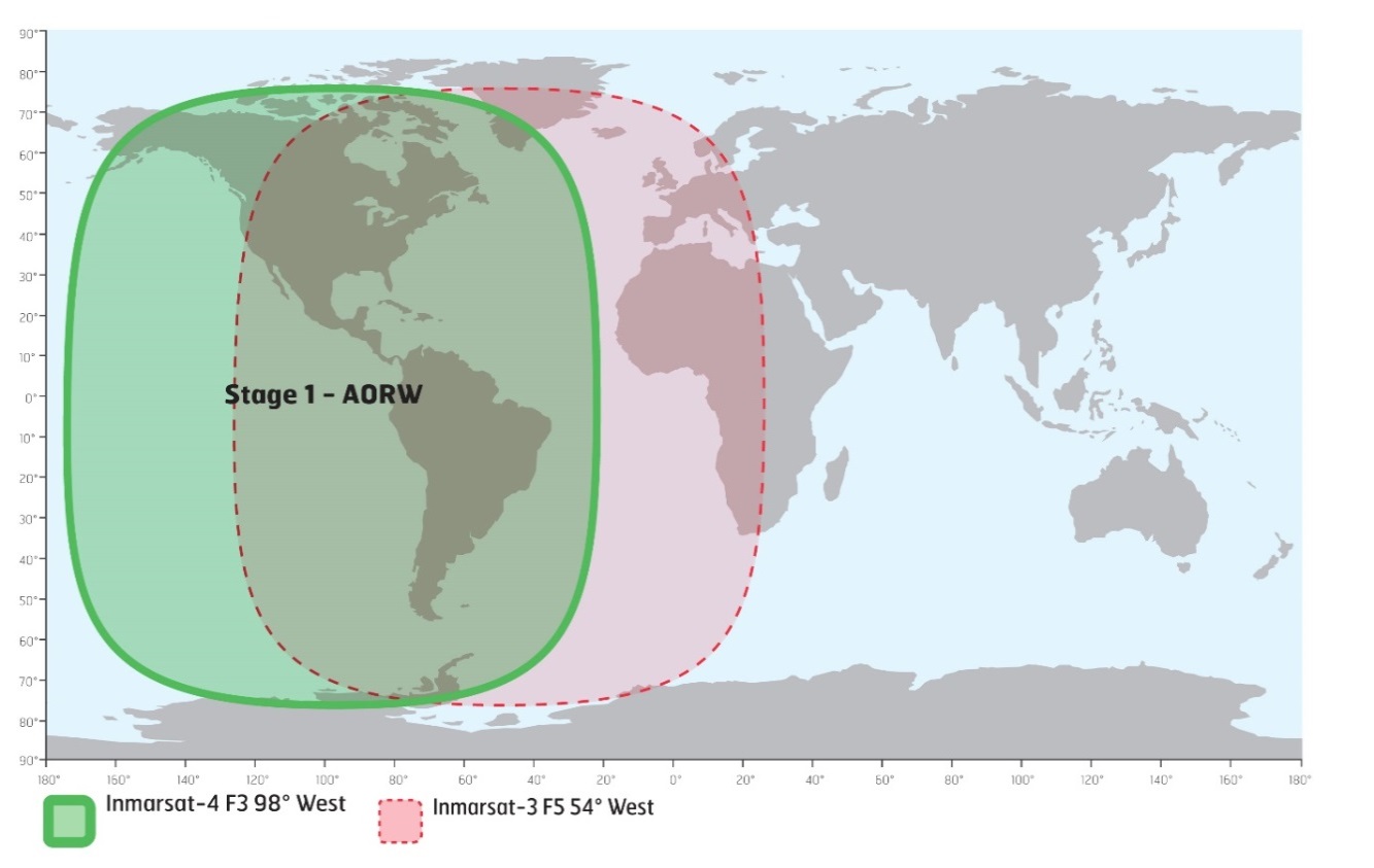
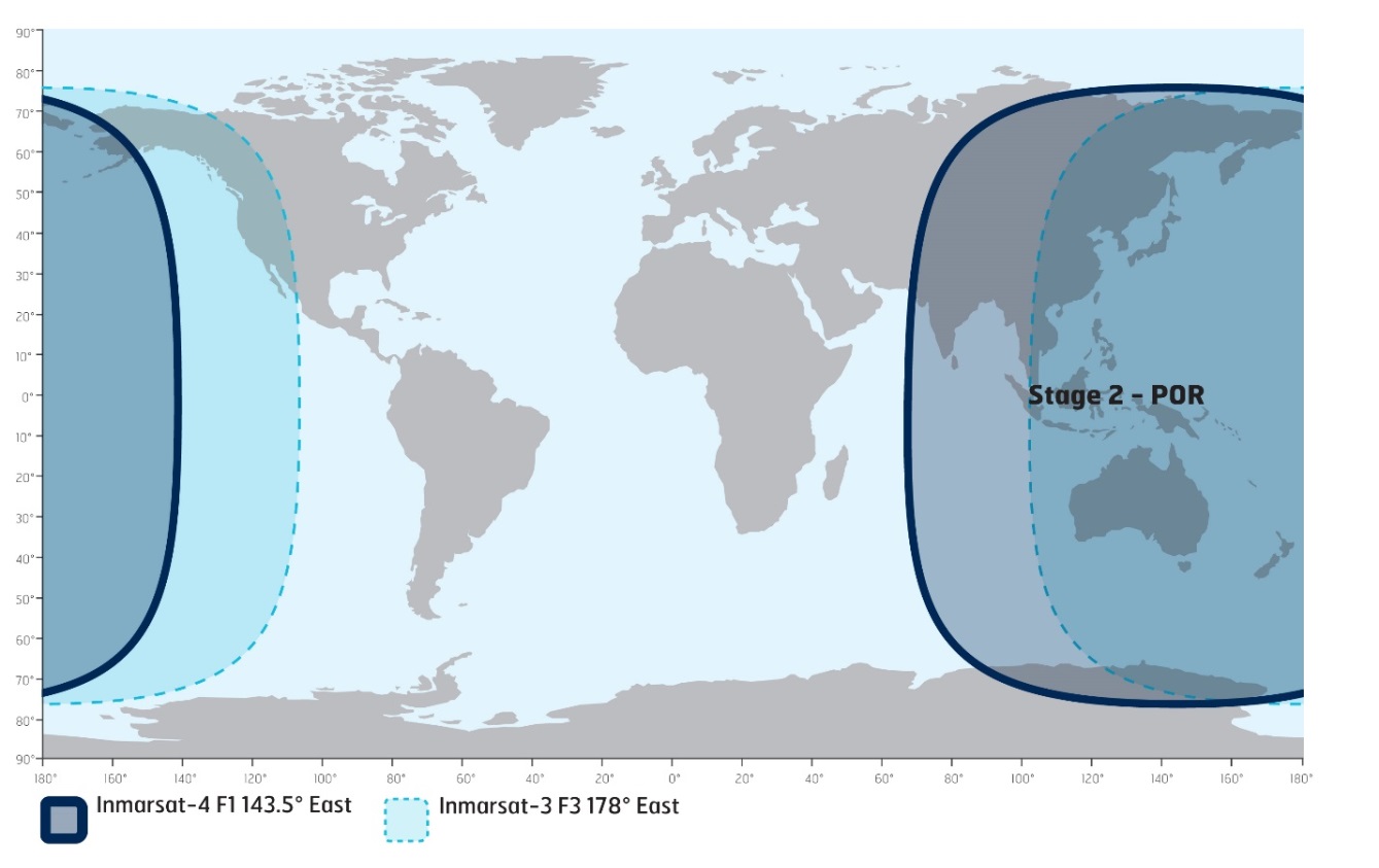
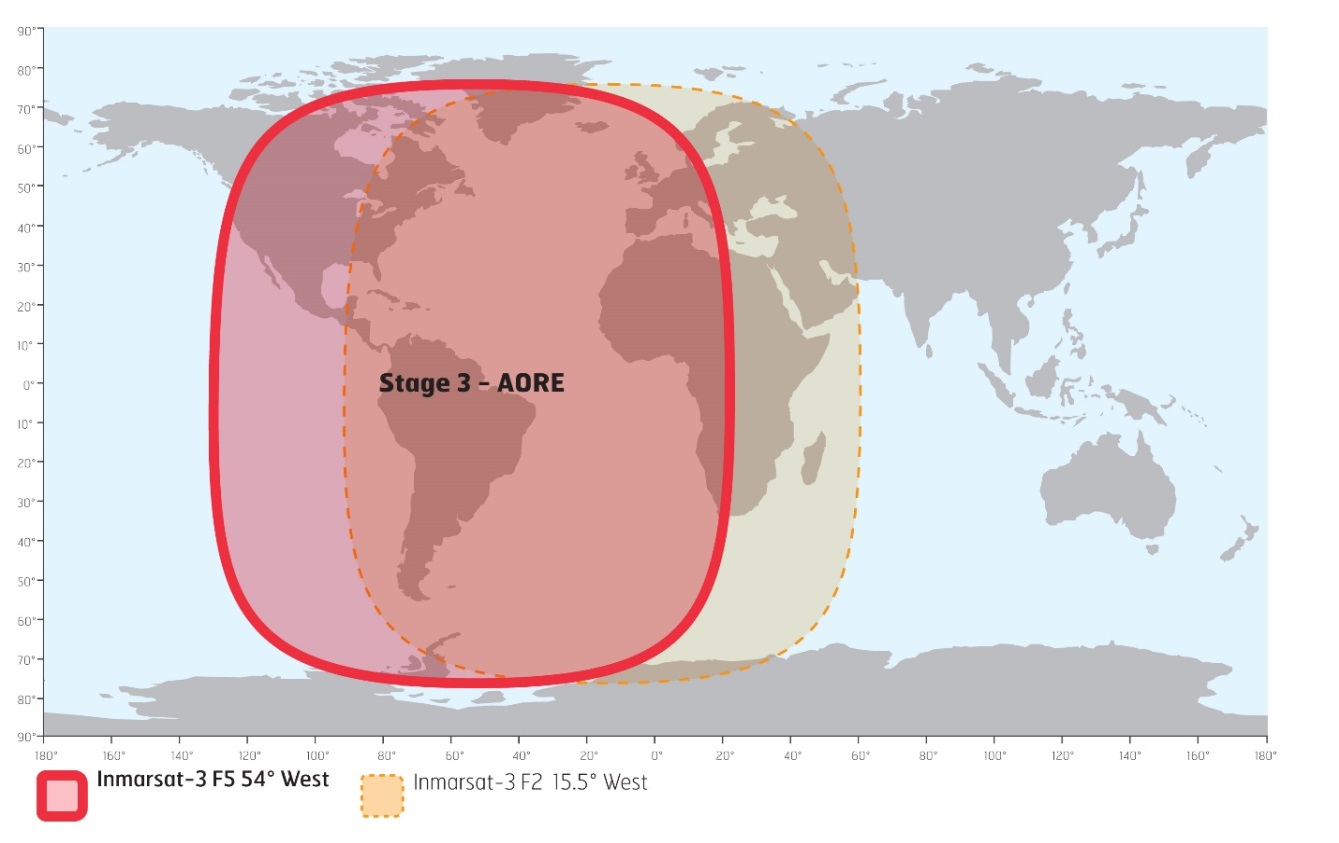
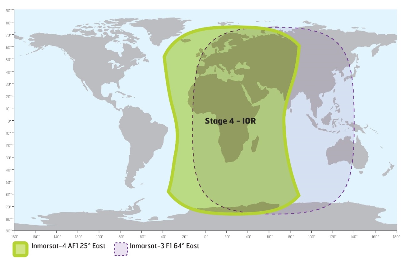
*316(T) MARINE COMMUNICATIONS AND TRAFFIC SERVICES – INMARSAT I-3 TO I-4 SATELLITE MIGRATION |
|||||||||||||||||||||||||||||||||||||||||||||||||||||||||||||||||||||||
|
The International Maritime Organization (IMO), the International Hydrographic Organization (IHO), and the World Meteorological Organization (WMO) inform the maritime community of the planned Inmarsat I-3 to I-4 satellite migration in 2018. The services specific to the maritime sector include Inmarsat-C, Mini C, and Fleet77. These services have operated successfully over the I-4 satellites previously and therefore minimal service impact is anticipated. Inmarsat worked closely with Land Earth Station operators (LESOs), terminal manufacturers, administrations that provide Maritime Safety Information (MSI) and other stakeholders during the extensive preparation of the migration plan. Safety services will be restored first with the highest priority. The migration will have minimal impact on seafarers. The migration will start in April 2018 and take approximately 9 months to complete. The approach of Inmarsat is to migrate these services satellite-by-satellite as illustrated below.
Stage 1: AORW to AMER, April 2018
Stage 2: POR to APAC, July 2018
Stage 3: AORE to I-3 F5, September 2018
Stage 4: IOR to Alphasat EMEA, October 2018
Inmarsat will be communicating with you throughout the migration planning and execution phases, providing additional details as and when they become available. Further information can be found at https://www.inmarsat.com/i3-i4-services-migration. If you have any immediate questions or concerns, please contact Inmarsat at: maritime.safety@inmarsat.com. |
|||||||||||||||||||||||||||||||||||||||||||||||||||||||||||||||||||||||