
Archived information
The Standard on Web Usability replaces this content. This content is archived because Common Look and Feel 2.0 Standards have been rescinded.
Archived information is provided for reference, research or recordkeeping purposes. It is not subject to the Government of Canada Web Standards and has not been altered or updated since it was archived.
Notices to Mariners
May 27, 2022

Safety First, Service Always
Monthly Western Edition
CONTENTS
| Section 1 | General and Safety Information |
| Section 1A | Temporary and Preliminary Notices |
| Section 2 | Chart Corrections |
| Section 3 | Radio Aids to Marine Navigation Corrections |
| Section 4 | Sailing Directions and Small Craft Guide Corrections |
| Section 5 | List of Lights, Buoys and Fog Signals Corrections |
Notices to Mariners – Monthly Western Edition
Edition No. 05/2022
Aussi disponible en français :
Avis aux navigateurs – Édition mensuelle de l’Ouest
Édition n° 05/2022
Published under the Authority of:
Canadian Coast Guard Programs
Aids to Navigation and Waterways
Fisheries and Oceans Canada
Montreal, QC H2Y 2E7
For more information, contact Notmar.XNCR@dfo-mpo.gc.ca.
© Her Majesty the Queen in Right of Canada,
as represented by the Minister of Fisheries, Oceans
and the Canadian Coast Guard, 2022.
Cat. No. Fs152-6E-PDF (Electronic PDF, English)
ISSN 1719-7708
Cat. No. Fs152-6F-PDF (Electronic PDF, French)
ISSN 1719-7716
Explanatory Notes – Notices to Mariners (NOTMAR)
Geographical positions refer directly to the graduations of the largest scale Canadian Hydrographic Service chart (unless otherwise indicated).
Bearings refer to the true compass and are measured clockwise from 000° (North) clockwise to 359°; those relating to lights are from seaward.
Visibility of lights is that in clear weather.
Depths - The units used for soundings (metres, fathoms or feet) are stated in the title of each chart.
Elevations are normally given above Higher High Water, Large Tide (unless otherwise indicated).
Distances may be calculated as follows:
1 nautical mile = 1,852 metres (6,076.1 feet)
1 statute mile = 1,609.3 metres (5,280 feet)
1 metre = 3.28 feet
Temporary and Preliminary Notices to Mariners – Section 1A of Notices to Mariners
These notices are indicated by a (T) or a (P), respectively. Please note that nautical charts are not amended by the Canadian Hydrographic Service for temporary (T) and preliminary (P) notices. It is recommended that mariners chart these corrections in pencil. For the list of charts affected by (T) & (P) notices, please refer to the current Notices to Mariners - Monthly Summary of Temporary and Preliminary Notices publication.
Suggestions and Corrections Form
This form is specifically for suggestions and corrections to Notices to Mariners publications. It is available online and also in fillable PDF format included with the monthly publication ZIP file.
To report chart discrepancies and/or corrections to the Sailing Directions booklets: Fill out the Marine Information Reporting Form and/or email chsinfo@dfo-mpo.gc.ca.
To report emergencies or navigational hazards: Contact your nearest MCTS centre
- VHF channel 16 (156.8 MHz)
- MF/HF frequency 2182 kHz/4125 kHz (where available)
- ∗16 on a cellphone (where available)
NOTMAR Website – Monthly Editions, Chart Corrections and Chart Patches
The NOTMAR website allows users to access the monthly publications,
chart corrections, and chart patches.
Users can subscribe for free to the email notification service
to receive notifications when charts of interest are updated, including their patches, as well as when a new Monthly Edition of Notices to Mariners is published.
In addition, the monthly publication and related
files to download, such as chart patches and Sailing
Directions diagrams, can be obtained all together
through the download of a single ZIP file.
Explanatory Notes – Canadian Hydrographic Service (CHS)
Chart Corrections – Section 2 of Notices to Mariners
Corrections to nautical charts will be listed in numerical order by chart number. Each chart correction listed applies only to that particular chart. Related charts, if any, will have their own specific correction listed separately.
Users should also refer to CHS Chart 1: Symbols, Abbreviations and Terms for additional information pertaining to the correction of charts.
The illustration below describes the elements that will comprise a typical Section 2 chart correction:

The last correction number is identified with the LNM/D or Last Notice to Mariners Number / Date.
Mariners are advised that only the most critical changes that directly affect safety to navigation are issued in “Section 2 – Chart Corrections.” This limitation is required to ensure that charts remain as clear and easy to read as possible. As a result, mariners may see minor discrepancies of a non-critical nature between information in official publications. For example, a small change in the nominal range or focal height of a light may not result in the production of a chart correction in Notices to Mariners, but may result in a correction in the List of Lights, Buoys and Fog Signals publication.
Note: In the case of a discrepancy between information provided on CHS charts relating to aids to navigation, and the List of Lights, Buoys and Fog Signals publication, the latter shall be deemed as containing the most up-to-date information.
Canadian Nautical Charts & Publications
A source list of Canadian nautical charts and publications is published in Notice No. 14 of the Notices to Mariners Annual Edition 2022. The source supply and the prices effective at the time of printing are listed. For current chart edition dates, please refer to the following website: www.chs-shc.gc.ca/charts-cartes/paper-papier/index-eng.asp
Explanatory Notes – Marine Communications and Traffic Services (MCTS)
Navigational Warnings / Notices to Shipping
The Canadian Coast Guard (CCG) is implementing a number of changes to the aids to navigation system in Canada.
These changes are advertised as Navigational Warnings, formerly called Notices to ShippingFootnote 1, that are broadcast by the CCG, and are then followed up with Notices to Mariners, then charts are updated by hand correction, reprints or new editions.
Mariners are advised that all relevant Navigational Warnings (NAVWARN) should be kept until superseded by Notices to Mariners or through revised charts issued by the Canadian Hydrographic Service (CHS).
NAVWARN are accessible on the applicable regional page on the CCG Navigational Warnings website at http://nis.ccg-gcc.gc.ca.
CHS is reviewing the impact of these changes with CCG and together are preparing an action plan on the issuing of chart revisions.
For further information, contact your regional NAVWARN Issuing Desk.
Western Region
Prince Rupert MCTS Centre
Canadian Coast Guard
Bag 4444
Prince Rupert, BC V8J 4K2
Telephone: 250-627-3070
Email: NAVWARN.MCTSPrinceRupert@innav.gc.ca
Website: http://www.marinfo.gc.ca/e-nav
Arctic Region
* Iqaluit MCTS Centre
Operational from approximately mid-May until late December.
Canadian Coast Guard
P.O. Box 189
Iqaluit, NU X0A 0H0
“A” Series
Telephone: 867-979-5269
“H” Series
Telephone: 867-979-0310
Facsimile: 867-979-4264
Email: NAVWARN.MCTSIqaluit@innav.gc.ca
Website: http://www.marinfo.gc.ca/e-nav
* Service available in English and French.
Index
Numerical Index of Canadian Charts Affected
This numerical index lists all nautical charts mentioned in this monthly edition of Notices to Mariners. Only charts appearing in Section 2 of this publication require a chart correction. The appearance of charts in all other sections, particularly those related to the correction of other nautical publications, is included here for reference.
| 1221 | 3604 | 3853 | 3963 |
| 3050 | 3605 | 3902 | 3977 |
| 3441 | 3623 | 3935 | 6112 |
| 3447 | 3624 | 3944 | 6206 |
| 3478 | 3646 | 3956 | 6207 |
| 3479 | 3680 | 3957 | 6212 |
| 3513 | 3727 | 3958 | 6218 |
| 3543 | 3808 | 3959 | 7486 |
SECTION 1 - GENERAL AND SAFETY INFORMATION
Canadian Coast Guard Publication – Comments and Suggestions on Notices to Mariners (NOTMAR) Publications
In an effort to continuously improve the Notices to Mariners publications and to provide the most efficient service possible, the Notices to Mariners team invites all mariners and other interested parties to submit comments and suggestions on possible improvements to its various publications and services at the following email address: Notmar.XNCR@dfo-mpo.gc.ca.
Transport Canada – COVID-19 Measures, Updates and Guidance
(Recurrent publication of notice *401/20, originally published in the Notices to Mariners – Monthly Western Edition 04/2020 publication.)
Please refer to the link below for the latest updates to
transportation related measures taken by Transport Canada in
response to the evolving novel Coronavirus disease
(COVID-19):
https://www.tc.gc.ca/en/initiatives/covid-19-measures-updates-guidance-tc.html.
For travel advice and all other updates, please visit: Canada.ca/coronavirus.
West Coast Haida Gwaii – Voluntary Protection Zone for Shipping
(Recurrent publication of notice *1105/21, originally published in the Notices to Mariners – Monthly Western Edition 11/2021 publication.)
Reference: Notice *903/21 is cancelled.

Voluntary Protection Zone for Shipping, West Coast Haida Gwaii (formerly Queen Charlotte Islands)
Haida Gwaii’s remote location, rugged coastline, variable sea
and weather conditions, and rich ecological and cultural
heritage make it vulnerable to the potential for pollution
from shipping breakdowns and accidents. Increasing the
distance vessels travel offshore can increase the amount of
time available to address propulsion, steering or other
issues, and the likelihood of a towing vessel being able to
respond to a vessel that is disabled or drifting. This in
turn reduces the risk of grounding and oil spills.
A Voluntary Protection Zone for Shipping on the West Coast of
Haida Gwaii is currently in effect. In the Voluntary
Protection Zone, commercial vessels of 500 gross tonnage or
greater shall observe a minimum distance of 50 nautical miles
offshore when transiting along the West Coast of Haida Gwaii
with the following exceptions:
–Cruise vessels, to observe a minimum 12 nm distance from shore;
–Vessels transiting between Pacific Northwest ports
(Washington, Alaska, BC), to observe a minimum 25 nm distance
from shore;
–Tugs and barges (including pushing and towing
alongside), no minimum distance; and
–Fishing vessels, no minimum distance.
The Voluntary Protection Zone for Shipping coordinates are:
|
54⁰ 15.436' N |
133⁰ 04.788' W |
|
54⁰ 17.572' N |
134⁰ 02.484' W |
|
54⁰ 13.614' N |
134⁰ 19.427' W |
|
54⁰ 11.786' N |
134⁰ 30.841' W |
|
53⁰ 44.036' N |
134⁰ 32.677' W |
|
53⁰ 11.118' N |
134⁰ 16.412' W |
|
52⁰ 18.483' N |
133⁰ 20.917' W |
|
51⁰ 24.590' N |
132⁰ 04.081' W |
|
51⁰ 56.158' N |
131⁰ 01.830' W |
Vessels are requested to adhere to these distances on a voluntary basis and only when it does not jeopardize the safety of navigation, the vessel, the persons aboard, and the cargo.
(NW-P-1085-20)
Transport Canada – Annual Edition of Notices to Mariners 2022 - Section A3, Notice 7A: Voyage Planning for Vessels Intending to Navigate in Canada's Northern Waters
(Recurrent publication of notice *206/22, originally published in the Notices to Mariners – Monthly Western Edition 02/2022 publication.)
Transport Canada has revised notice 7A, Voyage Planning for Vessels Intending to Navigate in Canada’s Northern Waters, of the Annual Edition of Notices to Mariners to reflect Arctic Shipping Safety and Pollution Prevention Regulations (ASSPPR) and to provide further guidance on voyage planning.
*501/22Canadian Hydrographic Service – Nautical Charts
|
Charts |
Main Title |
Scale |
Published |
Cat# |
Price |
|
New Editions |
|||||
|
1221 |
Pointe de Moisie à/to Île du Grand Caoui |
1:75 000 |
2022-05-13 |
1 |
$20.00 |
|
3447 |
Nanaimo Harbour and/et Departure Bay |
1:10 000 |
2022-05-13 |
2 |
$20.00 |
|
7486 |
Navy Channel to/à Fury and Hecla Strait |
1:150 000 |
2022-05-13 |
4 |
$20.00 |
*502/22Canadian Hydrographic Service – Electronic Navigational Charts
|
S-57 ENC Number |
Chart Title |
ENC Compilation Scale |
Published |
|
New Charts |
|||
|
CA571085 (Edn 1.000) |
Quottoon Narrows |
1:22 000 |
2022-05-06 |
|
CA670757 (Edn 1.000) |
Canexus |
1:2 000 |
2022-05-27 |
|
CA670761 (Edn 1.000) |
Pacific biological Station |
1:2 000 |
2022-05-20 |
|
New Editions |
|||
|
CA276322 (Edn 2.000) |
Cape Harrison to/à Nunaksaluk Island |
1:100 000 |
2022-05-20 |
|
CA376351 (Edn 3.000) |
Dog Islands to/à Cape Makkovik |
1:30 000 |
2022-05-13 |
|
CA376689 (Edn 2.000) |
North Head to/à Murphy Head |
1:50 000 |
2022-05-27 |
|
CA576005 (Edn 7.000) |
Saint John Harbour and Approaches / et les approches |
1:15 000 |
2022-05-13 |
|
Charts Permanently Withdrawn |
|||
|
CA570243 |
Quottoon Narrows |
|
|
*503/22Canadian Hydrographic Service – Raster Digital Charts (BSB V3)
|
Charts |
Main Title |
Scale |
Published |
|
New Editions |
|||
|
RM-3447 |
Nanaimo Harbour and/et Departure Bay |
1:10 000 |
2022-05-13 |
|
RM-7486 |
Navy Channel to/à Fury and Hecla Strait |
1:150 000 |
2022-05-13 |
*504/22Transport Canada – Ship Safety Bulletin #18/2021
An updated Ship Safety Bulletin has recently been posted on the Transport Canada website.
To view or download this bulletin, please click on the link below:
SSB#18/2021 – Measures to
Support Safe Cruise Travel in Canada (modified May 6,
2022)
RDIMS#
17917307
Sign up for e-Bulletin to receive an e-mail notice each time a new Ship Safety Bulletin is published on our website.
Contact us at marinesafety-securitemaritime@tc.gc.ca or 1-855-859-3123 (Toll Free).
*505/22Anguniaqvia niqiqyuam Marine Protected Area (ANMPA) and Tarium Niryutait Marine Protected Areas (TNMPA) – Beluga and Bowhead Whale Protection: Voluntary Avoidance and Slowdown Areas
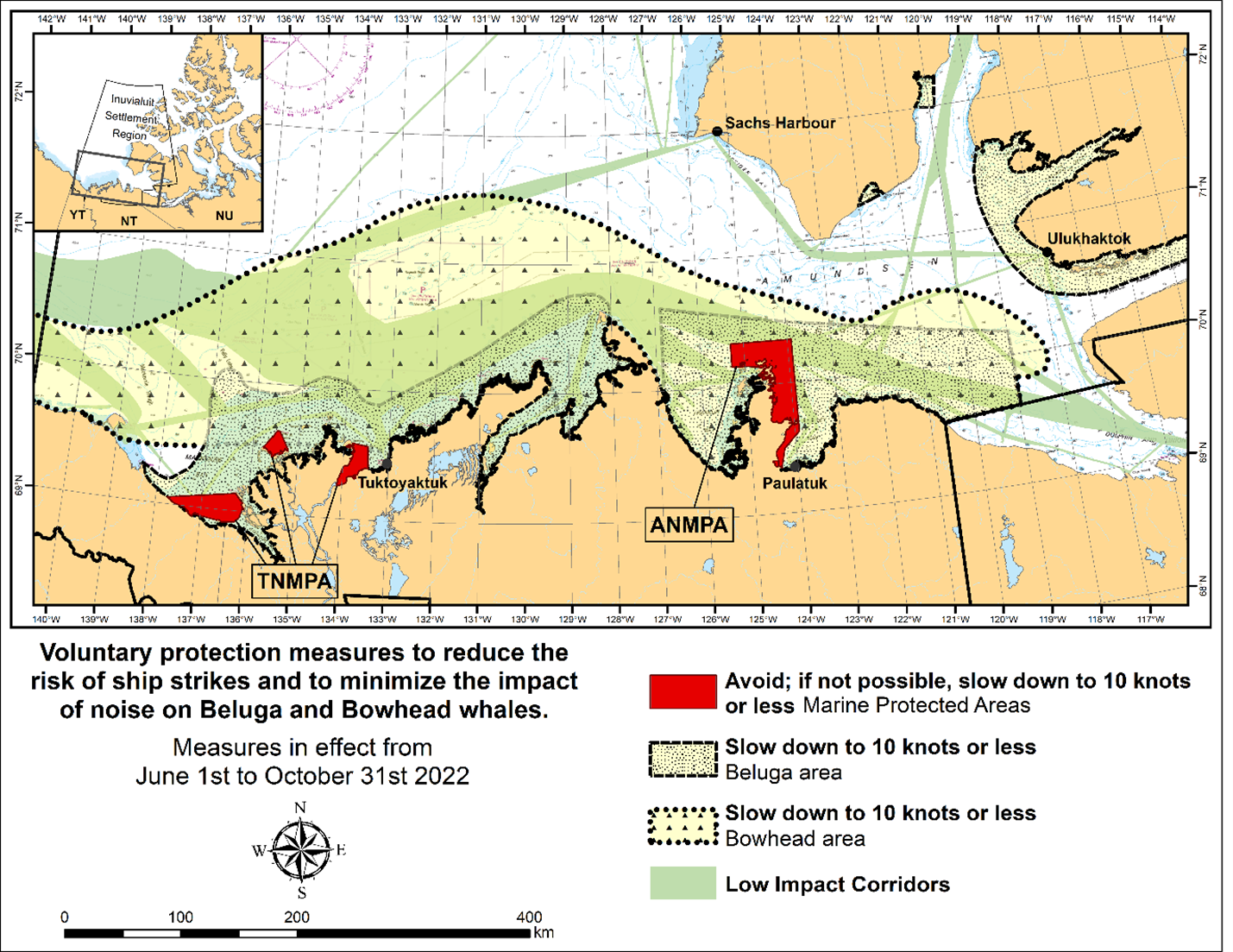
The two established Marine Protected Areas (MPAs) in Canada’s
Western Arctic are located within the Inuvialuit Settlement
Region, as such all activities must comply with the
Inuvialuit Final Agreement. Protection and preservation
of Arctic wildlife, the environment and biological
productivity is one of the principles of the Inuvialuit Final
Agreement and it is this principle that led the Inuvialuit
Regional Corporation and the Inuvialuit Game Council to
initiate establishment of the Western Arctic MPAs. The waters
in and near the MPAs, and the offshore marine habitats of the
Beaufort Sea and Amundsen Gulf, are important summer foraging
habitats used seasonally (May-October) by the Eastern
Beaufort Sea beluga stock, and the Bering-Chukchi-Beaufort
bowhead population.
REGULATORY PROTECTION MEASURES
All whale species are protected under the Marine Mammal Regulations, pursuant to the Fisheries Act. Within the boundaries of the MPAs, a general prohibition is set out in the Regulations, pursuant to the Oceans Act. Any incident with a marine mammal within the MPAs must be reported within two hours after its occurrence, to the Canadian Coast Guard. For marine wildlife sightings and incidents such as collisions that occur outside the MPAs or for any situation involving a marine mammal that is dead or in trouble, contact Fisheries and Oceans Canada, Inuvik office at (867) 777-7500.
For more information on the ANMPA and TNMPA, including local contacts and species specific minimum distances, see Section A2 - Notices 5 and 5A.3 of the Notices to Mariners Annual Edition 2022.
VOLUNTARY PROTECTION MEASURES
Voluntary measures are in effect from June 1st to October 31st, 2022. See map above.
These measures apply to merchant vessels, cruise ships, small
vessels and adventure craft within the boundaries of the MPAs
and the additional identified areas to prevent collisions
with whales and to mitigate the underwater noise generated by
the vessels. These measures should only be taken when they
will not jeopardize navigational safety.
Avoid (red area): To reduce the risk of
underwater noise disturbance and collisions with whales
within the MPAs, vessels should avoid transiting through the
MPAs if possible. If passage through this area is required,
vessels should slow down to a maximum speed through the water
of 10 knots and post a lookout such as a marine mammal
observer in order to increase the chances of seeing the
whales and thus taking necessary measures to avoid them. If
bypassing the whales is not possible, slow down and wait for
the animals to move away to a distance greater than 400
metres (0.215 nautical miles) before resuming original speed
up to 10 knots. It is more difficult to see the animals
in rain, fog, or in rough sea states, therefore increased
caution is recommended.
Slow down to 10 knots or less (yellow area):
To reduce the risk of underwater noise disturbance and
collisions with whales within this area, it is recommended
that vessels should slow down to a maximum speed through the
water of 10 knots, remain in the navigation and marked
community supply channels and post a lookout.
These voluntary measures are secondary to rights under the
Inuvialuit Final Agreement.
MPA Coordinates
The Tarium Niryutait Marine Protected Areas consist of three areas of the Mackenzie Bay: Okeevik, Kittigaryuit and Niaqunnaq. The three areas are bounded by rhumb lines connecting the following geographical coordinates [North America Datum 1983 (NAD 83)/World Geodetic System (WGS 84)].
|
Okeevik Sub Area |
|
Kittigaryuit Sub Area |
||||
|
Point |
Latitude (North) |
Longitude (West) |
|
Point |
Latitude (North) |
Longitude (West) |
|
1 |
69° 38’ 19” |
135° 25’ 09” |
|
1 |
69° 35’ 10” |
133° 48’ 26” |
|
2 |
69° 38’ 03” |
135° 25’ 11” |
|
2 |
69° 34’ 00” |
133° 28’ 00” |
|
3 |
69° 37’ 46” |
135° 24’ 52” |
|
3 |
69° 23’ 37” |
133° 26’ 40” |
|
4 |
69° 29’ 49” |
135° 12’ 49” |
|
4 |
69° 20’ 34” |
133° 40’ 37” |
|
5 |
69° 30’ 45” |
135° 16’ 56” |
|
5 |
69° 19’ 05” |
133° 42’ 21” |
|
6 |
69° 29’ 26” |
135° 18’ 53” |
|
6 |
69° 19’ 01” |
133° 42’ 31” |
|
7 |
69° 29’ 23” |
135° 19’ 06” |
|
7 |
69° 20’ 39” |
133° 43’ 20” |
|
8 |
69° 28’ 07” |
135° 20’ 25” |
|
8 |
69° 16’ 42” |
133° 54’ 54” |
|
9 |
69° 27’ 36” |
135° 24’ 25” |
|
9 |
69° 15’ 20” |
134° 06’ 53” |
|
10 |
69° 25' 51” |
135° 32’ 27” |
|
10 |
69° 16’ 33” |
134° 05’ 56” |
|
11 |
69° 26’ 32” |
135° 34’ 54” |
|
11 |
69° 20’ 42” |
134° 02’ 44” |
|
12 |
69° 28’ 21” |
135° 35’ 24” |
|
12 |
69° 24’ 00” |
133° 59’ 10” |
|
13 |
69° 28’ 35” |
135° 36’ 40” |
|
13 |
69° 24’ 34” |
133° 53’ 49” |
|
14 |
69° 28’ 39” |
135° 37’ 58” |
|
14 |
69° 28’ 21” |
133° 48’ 15” |
|
15 |
69° 30’ 34” |
135° 45’ 54” |
|
15 |
69° 28’ 02” |
133° 50’ 59” |
|
16 |
69° 35’ 18” |
135° 35’ 42” |
|
16 |
69° 33’ 20” |
133° 47’ 29” |
|
17 |
69° 36’ 00” |
135° 22’ 10” |
|
17 |
69° 34’ 33” |
133° 47’ 42” |
|
18 |
69° 34’ 40” |
135° 20’ 09” |
|
18 |
69° 32’ 55” |
133° 51’ 09” |
|
19 |
69° 34’ 00” |
135° 20’ 09” |
|
19 |
69° 32’ 56” |
133° 51’ 54” |
|
20 |
69° 34’ 00” |
135° 27’ 39” |
|
20 |
69° 33’ 46” |
133° 55’ 48” |
|
21 |
69° 36’ 00” |
135° 27’ 39” |
|
21 |
69° 33’ 46” |
133° 55’ 31” |
|
22 |
69° 27’ 00” |
135° 31’ 11” |
|
|
|
|
|
23 |
69° 27’ 00” |
135° 34’ 45” |
|
|
|
|
|
Niaqunnaq Sub Area |
||
|
Point |
Latitude (North) |
Longitude (West) |
|
1 |
69° 08’ 00” |
136° 16’ 44” |
|
2 |
69° 04’ 25” |
136° 07’ 45” |
|
3 |
69° 03’ 43” |
136° 07’ 08” |
|
4 |
69° 01’ 19” |
136° 04’ 45” |
|
5 |
69° 01’ 14” |
136° 04’ 45” |
|
6 |
69° 00’ 57” |
136° 05’ 42” |
|
7 |
69° 00’ 12” |
136° 07’ 08” |
|
8 |
68° 57’ 00” |
136° 10’ 00” |
|
9 |
68° 55’ 00” |
136° 15’ 00” |
|
10 |
68° 54’ 22” |
136° 31’ 50” |
|
11 |
68° 55’ 00” |
136° 38’ 33” |
|
12 |
68° 56’ 15” |
137° 00’ 41” |
|
13 |
68° 56’ 29” |
137° 03’ 03” |
|
14 |
68° 55’ 48” |
137° 11’ 00” |
|
15 |
68° 57’ 50” |
137° 16’ 40” |
|
16 |
68° 59’ 20” |
137° 21’ 30” |
|
17 |
69° 03’ 09” |
137° 44’ 54” |
The Anguniaqvia niqiqyuam Marine Protected Areas consist of two areas in Darnley Bay and Amundsen Gulf in the Beaufort Sea: Zone 1 and Zone 2. The areas consist of the seabed, the subsoil to a depth of five metres and the water column, including the sea ice. The two areas are bounded by straight lines connecting the following geographical coordinates [North America Datum 1983 (NAD 83)].
|
Zone 1 |
||
|
Point |
Latitude (North) |
Longitude (West) |
|
A |
69° 21’ 07.8” |
124° 21’ 32.0” approx |
|
B |
70° 12’ 00.0” approx |
124° 31’ 55.2” |
|
C |
70° 08’ 22.0” |
124° 41’ 45.0” approx |
|
D |
70° 09’ 09.9” |
124° 57’ 42.0” approx |
|
E |
70° 09’ 13.0” approx |
125° 05’ 28.6” |
|
F |
70° 09’ 13.2” |
125° 17’ 53.0” |
|
G |
70° 20’ 00.0” |
125° 17’ 53.0” |
|
H |
70° 20’ 00.0” |
123° 54’ 17.5” |
|
I |
69° 37’ 20.6” |
123° 54’ 17.5” |
|
J |
69° 30’ 00.0” |
124° 15’ 34.7” |
|
|
||
|
Zone 2 |
||
|
Point |
Latitude (North) |
Longitude (West) |
|
K |
70° 04’ 15.8” |
124° 41’ 51.0” approx |
|
L |
70° 04’ 48.6” |
124° 41’ 54.0” approx |
|
M |
70° 02’ 12.9” |
124° 35’ 23.0” approx |
|
N |
70° 02’ 12.9” |
124° 35’ 29.0” approx |
*506/22Canadian Coast Guard Publication – Amendments to the List of Lights, Buoys and Fog Signals Publication: Atlantic Coast
Please note that the following sections in the Atlantic Coast volume of the List of Lights, Buoys and Fog Signals publication are now separated into new distinct sections. Please see the table below for the complete list of changes.
|
Previous Sections |
New Sections |
|
Bay of Fundy, N.B. |
Bay of Fundy, N.B. – West |
|
Bay of Fundy, N.B. – East |
|
|
Gulf of St. Lawrence |
Northumberland
Strait – East |
|
Gulf of St. Lawrence |
|
|
Northumberland Strait |
Northumberland Strait – West |
*507/22Canadian Coast Guard Publication – List of Lights, Buoys and Fog Signals Publication: Pacific Coast – All Documents Now Available to Download as a Single PDF Document
The Notices to Mariners website has added a new download option for the List of Lights, Buoys and Fog Signals publication. The Front Cover and General Information Pages, all individual sections of the volume, and the Geographical and Designator Indexes can now be obtained together through the download of a single PDF document.
Currently, this option is only available for the Pacific Coast volume. Other volumes will be available at a later date.
Section 1A: Temporary and Preliminary Notices
Reminder – Comment Period for Active Preliminary Notices
No notices applicable for this edition.
Inland Waters
No notices applicable for this edition.
Pacific Coast
No notices applicable for this edition.
SECTION 2 - CHART CORRECTIONS
3050 - Kootenay River, Mile 0 to Mile 8.7 - Sheet/Feuille 1 - New Edition - 03-MAY-1996 - NAD 1927
(See Chart No. 1, M4)
and 48°59′54.9″N 116°30′11.0″W
3050 - Kootenay River, Mile 8.3 to Mile 16.5 - Sheet/Feuille 2 - New Edition - 03-MAY-1996 - NAD 1927
(See Chart No. 1, M4)
and 49°04′03.1″N 116°33′42.4″W
3050 - Kootenay River, Mile 15.8 to Mile 24.9 - Sheet/Feuille 3 - New Edition - 03-MAY-1996 - NAD 1927
(See Chart No. 1, M4)
and 49°08′28.7″N 116°35′37.9″W
3050 - Kootenay River, Mile 24.2 to Mile 29 - Sheet/Feuille 4 - New Edition - 03-MAY-1996 - NAD 1927
(See Chart No. 1, M4)
and 49°11′54.0″N 116°39′19.8″W
3050 - West Arm Kootenay Lake, Procter Light to Harrop Narrows - Sheet/Feuille 9 - New Edition - 03-MAY-1996 - NAD 1927
(See Chart No. 1, M4)
and 49°37′24.7″N 116°56′42.5″W
3050 - West Arm Kootenay Lake, Harrop Narrows to Nine Mile Narrows - Sheet/Feuille 10 - New Edition - 03-MAY-1996 - NAD 1927
(See Chart No. 1, M4)
and 49°36′38.1″N 117°02′32.3″W
3050 - West Arm Kootenay Lake, Nine Mile Narrows to Five Mile Point - Sheet/Feuille 11 - New Edition - 03-MAY-1996 - NAD 1927
(See Chart No. 1, M4)
and 49°36′00.2″N 117°09′11.0″W
3050 - West Arm Kootenay Lake, Five Mile Point to Nelson - Sheet/Feuille 12 - New Edition - 03-MAY-1996 - NAD 1927
(See Chart No. 1, M4)
and 49°33′29.8″N 117°14′13.2″W
3050 - West Arm Kootenay Lake, Nelson to Taghum - Sheet/Feuille 13 - New Edition - 03-MAY-1996 - NAD 1927
(See Chart No. 1, M4)
and 49°30′25.5″N 117°17′11.6″W
3050 - West Arm Kootenay Lake, Taghum to Corra Linn Dam - Sheet/Feuille 14 - New Edition - 03-MAY-1996 - NAD 1927
(See Chart No. 1, M4)
and 49°30′01.8″N 117°21′43.9″W
3441 - Haro Strait, Boundary Pass and/et Satellite Channel - New Edition - 01-JUL-2005 - NAD 1983
(See Chart No. 1, K48.2)
(See Chart No. 1, K11)
3478 - Fulford Harbour - New Edition - 12-JUL-2013 - NAD 1983
(See Chart No. 1, I10)
(See Chart No. 1, K11)
(See Chart No. 1, I10)
(See Chart No. 1, K11)
(See Chart No. 1, I10)
(See Chart No. 1, K11)
(See Chart No. 1, K11)
(See Chart No. 1, K11)
(See Chart No. 1, I10)
(See Chart No. 1, K11)
(See Chart No. 1, I10)
(See Chart No. 1, K11)
(See Chart No. 1, K11)
(See Chart No. 1, I10)
(See Chart No. 1, K11)
3479 - Approaches to/Approches à Sidney - New Chart - 18-MAY-2007 - NAD 1983
(See Chart No. 1, K48.1)
48°36′27.3″N 123°21′54.2″W
48°36′18.0″N 123°21′46.1″W
48°36′15.3″N 123°21′53.1″W
and 48°36′24.6″N 123°22′01.2″W
(See Chart No. 1, Qm)
(See Chart No. 1, Qm)
(See Chart No. 1, Qm)
(See Chart No. 1, Qm)
(See Chart No. 1, I10)
(See Chart No. 1, K11)
(See Chart No. 1, K11)
3479 - Iroquois Passage and/et John Passage - New Chart - 18-MAY-2007 - NAD 1983
(See Chart No. 1, I10)
(See Chart No. 1, I10)
(See Chart No. 1, K11)
(See Chart No. 1, K11)
3513 - Strait of Georgia, Northern Portion/Partie Nord - New Edition - 29-OCT-1999 - NAD 1983
(See Chart No. 1, K26)
3543 - Cordero Channel - New Edition - 27-NOV-1992 - NAD 1983
(See Chart No. 1, S4)
3604 - Nootka Sound to/à Quatsino Sound - New Edition - 06-NOV-1987 - NAD 1927
(See Chart No. 1, L25)
3605 - Quatsino Sound to/à Queen Charlotte Strait - New Edition - 06-MAR-1998 - NAD 1983
(See Chart No. 1, L25)
3623 - Kyuquot Sound to/à Cape Cook - New Edition - 26-AUG-1977 - NAD 1927
(See Chart No. 1, L25)
3624 - Cape Cook to Cape Scott - New Edition - 19-AUG-1988 - NAD 1927
(See Chart No. 1, L25)
3646 - Ucluelet Inlet - New Edition - 30-JUN-1995 - NAD 1983
(See Chart No. 1, K12)
(See Chart No. 1, I10)
(See Chart No. 1, I10)
(See Chart No. 1, I10)
(See Chart No. 1, I10)
(See Chart No. 1, I10)
(See Chart No. 1, I10)
Download Patch - https://www.notmar.gc.ca/chsftp/patches/3646_6204545_8_202204211437.pdf
3680 - Brooks Bay - New Edition - 07-APR-1978 - NAD 1927
(See Chart No. 1, L25)
3727 - Cape Calvert to Goose Island including Fitz Hugh Sound - New Edition - 23-SEP-2016 - World Geodetic System 1984
(See Chart No. 1, L25)
3808 - Juan Perez Sound - New Edition - 30-DEC-2005 - NAD 1983
(See Chart No. 1, L25)
3853 - Cape St. James to/à Cumshewa Inlet and/et Tasu Sound - New Edition - 02-MAR-1990 - NAD 1927
(See Chart No. 1, L25)
3902 - Hecate Strait - New Edition - 09-DEC-1988 - NAD 1927
(See Chart No. 1, L25)
3935 - Hakai Passage and Vicinity/et Environs - New Chart - 28-JAN-2000 - NAD 1983
(See Chart No. 1, L25)
3944 - Compartment B-C - New Chart - 21-SEP-2007 - NAD 1983
(See Chart No. 1, L25)
3956 - Malacca Passage to/à Bell Passage - New Edition - 13-JAN-2017 - World Geodetic System 1984
(See Chart No. 1, L25)
3957 - Approaches to/Approches à Prince Rupert Harbour - New Edition - 07-OCT-2016 - World Geodetic System 1984
(See Chart No. 1, L25)
(See Chart No. 1, Q58)
3958 - Butze Rapids - New Edition - 13-DEC-2013 - World Geodetic System 1984
(See Chart No. 1, K11)
(See Chart No. 1, K11)
(See Chart No. 1, K11)
3958 - Prince Rupert Harbour - New Edition - 13-DEC-2013 - World Geodetic System 1984
(See Chart No. 1, F33.1, F13)
54°18′25.7″N 130°20′35.5″W
54°18′19.3″N 130°20′48.9″W
54°18′18.9″N 130°20′48.5″W
54°18′19.1″N 130°20′47.8″W
54°18′19.4″N 130°20′48.1″W
and 54°18′25.2″N 130°20′35.8″W
(See Chart No. 1, I10)
3959 - Hudson Bay Passage - New Chart - 11-DEC-1987 - NAD 1983
(See Chart No. 1, L25)
3963 - Work Channel A-B - New Chart - 26-OCT-1990 - NAD 1983
(See Chart No. 1, L25)
3977 - Douglas Channel - New Chart - 27-DEC-2013 - World Geodetic System 1984
(See Chart No. 1, L25)
6112 - Rainy Lake/Lac à la pluie Southeast Portion/Partie sud-est Anchor Islands to/à Oakpoint Island - Sheet/Feuille 1 - New Edition - 27-MAY-2005 - NAD 1983
(See Chart No. 1, Q21)
(See Chart No. 1, Q20)
6206 - Seven Sisters Falls to/à Slave Falls - Sheet/Feuille 1 - New Edition - 15-SEP-2000 - NAD 1983
(See Chart No. 1, D27)
and 50°13′43.3″N 095°33′22.2″W
(See Chart No. 1, A14)
(See Chart No. 1, N61)
50°13′45.8″N 095°33′30.5″W
and 50°13′50.4″N 095°33′27.5″W
(See Chart No. 1, Qs)
(See Chart No. 1, Qs)
6207 - Continuation A - Sheet/Feuille 1 - New Edition - 24-MAR-2000 - NAD 1983
(See Chart No. 1, D27)
and 50°13′43.3″N 095°33′22.2″W
(See Chart No. 1, A14)
(See Chart No. 1, N61)
50°13′45.8″N 095°33′30.5″W
and 50°13′50.4″N 095°33′27.5″W
6212 - Kenora to/à Aulneau Peninsula - New Edition - 28-FEB-2020 - NAD 1983
(See Chart No. 1, Q58)
to 49°39′18.6″N 094°30′43.8″W
(See Chart No. 1, Qg)
6218 - Kenora, Rat Portage Bay - New Edition - 28-FEB-2020 - NAD 1983
(See Chart No. 1, Qg)
SECTION 3 - RADIO AIDS TO MARINE NAVIGATION CORRECTIONS
*520/22Radio Aids to Marine Navigation 2022 (Atlantic, St. Lawrence, Great Lakes, Lake Winnipeg, Arctic and Pacific)
Page 4-14
AMEND FOLLOWS:
4.2.1.3Maritime Safety Information (MSI)
Maritime Safety Information broadcasts, which comprise navigational and meteorological warnings, meteorological forecasts and other safety-related messages can be received in four different ways in GMDSS:
a)NAVTEX receivers are fully automatic and receive broadcasts in coastal regions up to 300 nautical miles offshore;
b)Inmarsat-C terminals Terminals to receive Enhanced
Group Calls (EGC)
– SafetyNET broadcasts for areas
outside NAVTEX coverage using
SafetyNET, SafetyNET II and SafetyCast;
c)High
Frequency Narrow-Band-Direct-Printing (HF NBDP) receivers may
be used where service is available to promulgate MSI in areas outside Inmarsat coverage; and
d)VHF marine radio (Sea Area A1) as a medium for obtaining nav/met MSI.
Page 4-21
AMEND:
4.2.1.8Canadian Coast Guard Marine Communications and Traffic Services Centres (MCTS)
…
To supplement the broadcasting of Maritime Safety Information
(MSI) on NAVTEX, Inmarsat, SafetyNET and HF NBDP, MCTS Centres
will continue MSI broadcasts using the existing VHF continuous
marine broadcast system and MF radiotelephony broadcast at
advertised times.
TO READ:
4.2.1.8Canadian Coast Guard Marine Communications and Traffic Services Centres (MCTS)
…
To supplement the broadcasting of Maritime Safety Information (MSI) on NAVTEX, Inmarsat SafetyNET/SafetyNET II, Iridium SafetyCast and HF NBDP, MCTS Centres will continue MSI broadcasts using the existing VHF continuous marine broadcast system and MF radiotelephony broadcast at advertised times.
Pages 4-66 to 4-67
DELETE THE FOLLOWING SECTION:
4.3.3.1NAVAREAS XVII and XVIII: Navigational Warnings
REPLACE AS FOLLOWS:
4.3.3.1NAVAREAS XVII and XVIII: Navigational Warnings
The Canadian Coast Guard has assumed responsibility of NAVAREA
coordination for NAVAREAs XVII and XVIII as part of the
World-Wide Navigational Warning Service (WWNWS).
Under the WWNWS, navigational warnings containing urgent
information relevant to safe navigation that are broadcast in
accordance with the Chapter IV of the International Convention
for the Safety of Life at Sea (SOLAS).
NAVAREA warnings, which contain information specific to ocean
going mariners, remain in force until cancelled or promulgated
by other means.
NAVAREA XVII and XVIII warnings that are less than 42 days old
are promulgated via SafetyNET II and SafetyCast.
The complete text of all In-Force NAVAREA warnings is available
from the Canadian Coast Guard website: Search
- Canadian Coast Guard (ccg-gcc.gc.ca)
Alternatively, these may be requested by forwarding an email to
the NAVAREA Operations desk at: navarea17.18@innav.gc.ca.
Figure 4-18 - Canadian NAVAREA Zones and Broadcast Areas
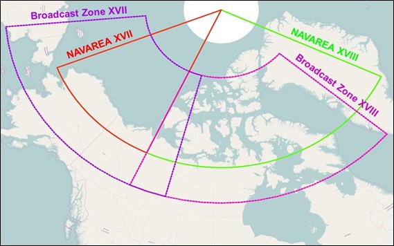
During the Arctic navigational season, NAVAREA XVII and XVIII warnings applicable to the Canadian Search and Rescue boundaries for waters North of 70 degrees latitude are broadcast (with limits to coverage area and reliability) using High Frequency Narrow Band Direct Printing (HF NBDP) on 8416.5 kHz at 03:30 UTC and 15:30 UTC. Refer to Iqaluit MCTS in Part 2 for details about the broadcast content.
Table 4-15 - Broadcast Schedule
|
Hour UTC |
Service |
Frequency, Satellite, or System |
|
0330 |
HF NBDP |
8416.5 kHz* |
|
1100 |
NAV XVIII |
AMER, SafetyCast |
|
1130 |
NAV XVII |
APAC, SafetyCast |
|
1530 |
HF NBDP |
8416.5 kHz* |
|
2300 |
NAV XVIII |
AMER, SafetyCast |
|
2330 |
NAV XVII |
APAC, SafetyCast |
*Available during Arctic navigational season
Comments concerning the reception of NAVAREA XVII and XVIII broadcasts, especially above 75°N, would be appreciated and should be sent to:
NAVAREA XVII and XVIII
Prescott MCTS Centre
Telephone:613-925-0666
Facsimile: 613-925-4519
E-mail: navarea17.18@innav.gc.ca
4.3.3.1.1SafetyNET
NAVAREAs XVII and XVIII warnings are broadcast in the English
language using the following rectangular areas until SafetyNET
Inmarsat-C or Mini-C maritime terminals operating in the arctic
waters have been updated:
NAVAREA
XVIINAVAREA
XVIII
82°00N 175°00E 82°00N
120°00W
82°00N 120°00W 82°00N 035°00W
62°00N 120°00W 62°00N 035°00W
62°00N 175°00E 62°00N 120°00W
To learn more about the
Inmarsat SafetyNET service, please consult their website or
the SafetyNET manual (MSC.1/Circ.1364/Rev.2).
Reception of rectangular addressed messages should be automatic
providing the ship’s position is inside the addressed area.
However, mariners should check their manufacturer’s operation
manuals to obtain information on the setting of their EGC
equipment to receive relevant SafetyNET messages.
4.3.3.1.2SafetyCast
NAVAREAs XVII and XVIII warnings are broadcast in the English language directly into the appropriate GMDSS NAVAREA zone, with a broadcast overlap of 300 NM.
To learn more about the Iridium SafetyCast service, please consult their website or the SafetyCast Manual (MSC.1/Circ.1613).
Page 4-67
ADD AS FOLLOWS:
4.3.3.2NAVAREAS IV and XII
The National Geospatial-Intelligence Agency (NGA) of the United
States of America is responsible for NAVAREAs IV and XII
coordination.
NAVAREA IV covers the North Atlantic Ocean West of 35°W and
north of 7°N. NAVAREA IV warnings are broadcasts over the
Iridium SafetyCast and
Inmarsat AMER satellites at 10:00 UTC and 22:00 UTC. Ice
reports for the North Atlantic are broadcast at 22:00 UTC.
NAVAREA IV warnings are broadcast over HF NBDP from: Boston
(NMF) at 01:40 UTC on 6314 kHz, 8416.5 kHz, and 12579 kHz
and at 16:30 UTC on 8416.5 kHz, 12579 kHz, and 16806.5
kHz.
NAVAREA XII covers the North Pacific Ocean east of 180° and
north of the equator, plus the area north of 3°25’S and east of
120°W. NAVAREA XII warnings are broadcasts over the
Iridium SafetyCast and
Inmarsat APAC satellites at 10:30 UTC and 22:30 UTC.
These messages are broadcast over HF NBDP by Honolulu (NMO) at
03:30 and 17:30 UTC daily, on 8416.5 kHz, 12579 kHz, and
22376 kHz.
…
Page 5-27
AMEND:
5.9.7METAREAs Forecast Transmission
During the navigation season, met MSI for sections of METAREA XVII and XVIII south of 75°N, and northwestern sections of METAREA IV, is broadcast via Inmarsat-C SafetyNET over Inmarsat’s Asia-Pacific (APAC) or Americas (AMER) or Atlantic Ocean Region-West (AOR-W) satellite network. Scheduled broadcast times are:
METAREA XVII (APAC & AMER) at 03:00 UTC and 15:00 UTC
daily.
METAREA XVIII (AMER & AOR-W) at 03:00 UTC and 15:00 UTC
daily.
Northwestern METAREA IV (AMER) at 03:00 UTC and 15:00 UTC
daily.
TO READ:
5.9.7METAREAs Forecast Transmission
During the navigation season, met MSI issued for METAREAs XVII and XVIII and northwestern sections of METAREA IV is broadcast via both Iridium SafetyCast and Inmarsat SafetyNET, noting the following:
1.SafetyCast met MSI is broadcast directly into the GMDSS METAREA zones; and
2.SafetyNET met MSI for sections of METAREA XVII and XVIII south of 75°N, and northwestern sections of METAREA IV, is broadcast over Inmarsat’s Asia-Pacific (APAC), Americas (AMER) or Atlantic Ocean Region-West (AOR-W) satellite network.
Scheduled broadcast times are:
|
Broadcast Hour (UTC) |
Met MSI Transmission Area |
Transmitting Satellite |
|
|
03:00 and 15:00 daily |
METAREA XVII |
Inmarsat (APAC & AMER) |
Iridium |
|
03:00 and 15:00 daily |
METAREA XVIII |
Inmarsat (AMER & AOR-W) |
Iridium |
|
03:00 and 15:00 daily |
Northwestern METAREA IV |
Inmarsat (AMER) |
Iridium |
SECTION 4 - SAILING DIRECTIONS AND SMALL CRAFT GUIDE CORRECTIONS
The following Canadian Sailing Directions volumes have recently been updated on the Canadian Hydrographic Service website.
|
No. |
Title |
|
Atlantic Coast |
|
|
ATL 110 |
St. Lawrence River, Cap Whittle / Cap Gaspé to Les Escoumins and Anticosti Island |
|
ATL 112 |
St. Lawrence River, Cap-Rouge to Montréal and Rivière Richelieu |
|
Pacific Coast |
|
|
PAC 201 |
Juan de Fuca Strait and Strait of Georgia |
|
PAC 202 |
Discovery Passage to Queen Charlotte Strait and West Coast of Vancouver Island |
Each volume includes a section entitled “Record of Changes” which lists all updates that are incorporated during the current calendar year.
SECTION 5 - LIST OF LIGHTS, BUOYS AND FOG SIGNALS CORRECTIONS
NO CORRECTIONS FOR THIS SECTION.
Report a problem on this page
- Date modified: