
Archived information
The Standard on Web Usability replaces this content. This content is archived because Common Look and Feel 2.0 Standards have been rescinded.
Archived information is provided for reference, research or recordkeeping purposes. It is not subject to the Government of Canada Web Standards and has not been altered or updated since it was archived.
Notices to Mariners
March 26, 2021

Safety First, Service Always
Monthly Western Edition
CONTENTS
| Section 1 | General and Safety Information |
| Section 1A | Temporary and Preliminary Notices |
| Section 2 | Chart Corrections |
| Section 3 | Radio Aids to Marine Navigation Corrections |
| Section 4 | Sailing Directions and Small Craft Guide Corrections |
| Section 5 | List of Lights, Buoys and Fog Signals Corrections |
Notices to Mariners – Monthly Western Edition
Edition No. 03/2021
Aussi disponible en français :
Avis aux navigateurs – Édition mensuelle de l’Ouest
Édition n° 03/2021
Published under the Authority of:
Canadian Coast Guard Programs
Aids to Navigation and Waterways
Fisheries and Oceans Canada
Montreal, QC H2Y 2E7
For more information, contact Notmar.XNCR@dfo-mpo.gc.ca.
© Her Majesty the Queen in Right of Canada,
as represented by the Minister of Fisheries, Oceans
and the Canadian Coast Guard, 2021.
Cat. No. Fs152-6E-PDF (Electronic PDF, English)
ISSN 1719-7708
Cat. No. Fs152-6F-PDF (Electronic PDF, French)
ISSN 1719-7716
Explanatory Notes – Notices to Mariners (NOTMAR)
Geographical positions refer directly to the graduations of the largest scale Canadian Hydrographic Service chart (unless otherwise indicated).
Bearings refer to the true compass and are measured clockwise from 000° (North) clockwise to 359°; those relating to lights are from seaward.
Visibility of lights is that in clear weather.
Depths - The units used for soundings (metres, fathoms or feet) are stated in the title of each chart.
Elevations are normally given above Higher High Water, Large Tide (unless otherwise indicated).
Distances may be calculated as follows:
1 nautical mile = 1,852 metres (6,076.1 feet)
1 statute mile = 1,609.3 metres (5,280 feet)
1 metre = 3.28 feet
Temporary and Preliminary Notices to Mariners – Section 1A of Notices to Mariners
These notices are indicated by a (T) or a (P), respectively.
Please note that nautical charts are not amended by the Canadian Hydrographic Service for temporary (T) and preliminary (P) notices. It
is recommended that mariners chart these corrections in pencil. For the list of charts affected by (T) & (P) notices,
please refer to the current Notices to Mariners - Monthly Summary of Temporary and Preliminary Notices
publication.
Please note: In addition to the temporary and preliminary changes normally advertised as (T) & (P) notices, there are a few permanent changes to aids to navigation that have been advertised as preliminary Notices to Mariners while charts are being updated for new editions.
Marine Information Report and Suggestion Sheet
Mariners are requested to notify the responsible authorities when new or suspected dangers to navigation are discovered, changes observed in aids to navigation or corrections to publications are seen
to be necessary. Such communications can be made using the "Marine Information Report and Suggestion Sheet" (fillable PDF form) and is inserted on the last
page of each monthly edition of Notices to Mariners.
NOTMAR Website – Monthly Editions, Chart Corrections and Chart Patches
The NOTMAR website allows users to access the monthly publications,
chart corrections, and chart patches.
Users can subscribe for free to the email notification service
to receive notifications when charts of interest are updated, including their patches, as well as when a new monthly edition becomes available online.
In addition, the monthly publication and related
files to download, such as chart patches and Sailing
Directions diagrams, can be obtained all together
through the download of a single ZIP file.
Explanatory Notes – Canadian Hydrographic Service (CHS)
Chart Corrections – Section 2 of Notices to Mariners
Corrections to nautical charts will be listed in numerical order by chart number. Each chart correction listed applies only
to that particular chart. Related charts, if any, will have their own specific correction listed separately.
Users should also refer to CHS Chart 1: Symbols, Abbreviations and Terms for additional information pertaining to the correction of charts.
The illustration below describes the elements that will comprise a typical Section 2 chart correction:

The last correction number is identified with the LNM/D or Last Notice to Mariners Number / Date.
Mariners are advised that only the most critical changes that directly affect safety to navigation are issued in “Section 2 – Chart Corrections.” This limitation is required to ensure that charts remain as clear and easy to read as possible. As a result, mariners may see minor discrepancies of a non-critical nature between information in official publications. For example, a small change in the nominal range or focal height of a light may not result in the production of a chart correction in Notices to Mariners, but may result in a correction in the List of Lights, Buoys and Fog Signals publication.
Note: In the case of a discrepancy between information provided on CHS charts relating to aids to navigation, and the List of Lights, Buoys and Fog Signals publication, the latter shall be deemed as containing the most up-to-date information.
Canadian Nautical Charts & Publications
A source list of Canadian nautical charts and publications is published in Notice No. 14 of the Notices to Mariners Annual Edition 2021. The source supply and the prices
effective at the time of printing are listed. For current chart edition dates, please refer to the following website:
www.chs-shc.gc.ca/charts-cartes/paper-papier/index-eng.asp
Explanatory Notes – Marine Communications and Traffic Services (MCTS)
Navigational Warnings / Notices to Shipping
The Canadian Coast Guard (CCG) is implementing a number of changes to the aids to navigation system in Canada.
These changes are advertised as Navigational Warnings, formerly called Notices to ShippingFootnote 1, that are broadcast by the CCG, and are then followed up with Notices to Mariners, then charts are updated by hand correction, reprints or new editions.
Mariners are advised that all relevant Navigational Warnings (NAVWARNs) should be kept until superseded by Notices to Mariners or through revised charts issued by the Canadian Hydrographic Service (CHS).
NAVWARNs are accessible on the applicable regional page on the CCG Navigational Warnings website at http://nis.ccg-gcc.gc.ca.
CHS is reviewing the impact of these changes with CCG and together are preparing an action plan on the issuing of chart revisions.
For further information, contact your regional NAVWARN Issuing Desk.
Western Region
Prince Rupert MCTS Centre
Canadian Coast Guard
Bag 4444
Prince Rupert, BC V8J 4K2
Telephone: 250-627-3070
Email: NAVWARN.MCTSPrinceRupert@innav.gc.ca
Website: http://www.marinfo.gc.ca/e-nav
Arctic Region
* Iqaluit MCTS Centre
Operational from approximately mid-May until late December.
Canadian Coast Guard
P.O. Box 189
Iqaluit, NU X0A 0H0
“A” Series
Telephone: 867-979-5269
“H” Series
Telephone: 867-979-0310
Facsimile: 867-979-4264
Email: NAVWARN.MCTSIqaluit@innav.gc.ca
Website: http://www.marinfo.gc.ca/e-nav
* Service available in English and French.
Index
Numerical Index of Canadian Charts Affected
This numerical index lists all nautical charts mentioned in this monthly edition of Notices to Mariners. Only charts appearing in Section 2 of this publication require a chart correction. The appearance of charts in all other sections, particularly those related to the correction of other nautical publications, is included here for reference.
| 3410 | 3475 | 3493 | 3895 |
| 3411 | 3477 | 3606 | 4473 |
| 3441 | 3478 | 3670 | 4968 |
| 3442 | 3490 | 3671 | |
| 3443 | 3491 | 3893 |
SECTION 1 - GENERAL AND SAFETY INFORMATION
Canadian Coast Guard Publication – Comments and Suggestions on Notices To Mariners (NOTMAR) Publications
In an effort to continuously improve the Notices to Mariners publications and to provide the most efficient service possible, the Notices to Mariners team invites all mariners and other interested parties to submit comments and suggestions on possible improvements to its various publications and services at the following email address: Notmar.XNCR@dfo-mpo.gc.ca.
Transport Canada – COVID-19 Measures, Updates and Guidance
(Recurrent publication of notice *401/20, originally published in the Notices to Mariners – Monthly Western Edition 04/2020 publication.)
Please refer to the link below for the latest updates to
transportation related measures taken by Transport Canada in
response to the evolving novel Coronavirus disease
(COVID-19):
https://www.tc.gc.ca/en/initiatives/covid-19-measures-updates-guidance-tc.html.
For travel advice and all other updates, please visit: Canada.ca/coronavirus.
Canadian Hydrographic Service – Canadian Tide and Current Tables – Printing to be Discontinued
(Recurrent publication of notice *904/20, originally published in the Notices to Mariners – Monthly Western Edition 09/2020 publication.)
Due to the availability of the Canadian Tide and Current Tables as viewable and printable PDF files on charts.gc.ca for each complete volume and additional information in different formats (predictions, observations in tables, and graphics) on tides.gc.ca, the Canadian Hydrographic Service is permanently discontinuing the printing of all volumes of Canadian Tide and Current Tables starting January 2021.
Advances in technology bring a new era of marine navigation with a focus on digital and electronic products. The Canadian Hydrographic Service is transforming the way it delivers quality data and services to clients, in a timely manner, to support decision-making.
For more information, visit www.charts.gc.ca.
Canadian Hydrographic Service – Chart 1 – Printing to be Discontinued
(Recurrent publication of notice *905/20, originally published in the Notices to Mariners – Monthly Western Edition 09/2020 publication.)
Due to the availability of Chart 1: Symbols, Abbreviations and Terms as both viewable and printable PDF files and HTML format on charts.gc.ca, the Canadian Hydrographic Service is permanently discontinuing the printing of Chart 1: Symbols, Abbreviations and Terms starting January 2021.
Advances in technology bring a new era of marine navigation with a focus on digital and electronic products. The Canadian Hydrographic Service is transforming the way it delivers quality data and services to clients, in a timely manner, to support decision-making.
For more information, visit www.charts.gc.ca.
Canadian Hydrographic Service – Notices to Mariners for Changes in Buoy Shape
(Recurrent publication of notice *906/20, originally published in the Notices to Mariners – Monthly Western Edition 09/2020 publication.)
As part of the CHS Digital Transformation and for the sake of economy, CHS will no longer systematically issue Notices to Mariners (NTM) for buoy shape changes only. These changes will, however, be applied to electronic navigation charts (ENCs) where applicable. The paper and raster versions will be updated during the New Edition process.
West Coast Haida Gwaii – Trial Voluntary Protection Zone for Shipping
(Recurrent publication of notice *107/21, originally published in the Notices to Mariners – Monthly Western Edition 01/2021 publication.)
Reference: Notice *1005/20 is cancelled.
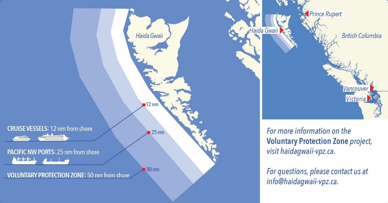
Trial Voluntary Protection Zone for Shipping, West Coast Haida Gwaii (formerly Queen Charlotte Islands)
Haida Gwaii’s remote location, rugged coastline, variable sea
and weather conditions, and rich ecological and cultural
heritage make it vulnerable to the potential for pollution from
shipping breakdowns and accidents. Increasing the distance
vessels travel offshore can increase the amount of time
available to address propulsion, steering or other issues, and
the likelihood of a towing vessel being able to respond to a
vessel that is disabled or drifting. This in turn reduces the
risk of grounding and oil spills.
A trial Voluntary Protection Zone for Shipping on the West
Coast of Haida Gwaii will be in effect from September 1, 2020
through October 31, 2021. In the Voluntary Protection Zone,
commercial vessels of 500 gross tonnage or greater shall
observe a minimum distance of 50 nautical miles offshore when
transiting along the West Coast of Haida Gwaii with the
following exceptions:
–Cruise vessels, to observe a minimum 12 nm distance from shore;
–Vessels
transiting between Pacific Northwest ports (Washington,
Alaska, BC), to observe a minimum 25 nm distance from
shore;
–Tugs and
barges (including pushing and towing alongside), no minimum
distance; and
–Fishing vessels, no minimum distance.
The Voluntary Protection Zone for Shipping coordinates are:
|
54⁰ 18.108’N |
134⁰ 30.432’W |
|
53⁰ 44.036’N |
134⁰ 32.677’W |
|
53⁰ 11.118’N |
134⁰ 16.412’W |
|
52⁰ 18.483’N |
133⁰ 20.917’W |
|
51⁰ 24.590’N |
132⁰ 04.081’W |
|
51⁰ 56.158’N |
131⁰ 01.830’W |
|
54⁰ 15.436’N |
133⁰ 04.788’W |
Vessels are requested to adhere to these distances on a voluntary basis and only when it does not jeopardize the safety of navigation, the vessel, the persons aboard, and the cargo.
(NW-P-1085-20)
Erratum: Section 2 – Chart Corrections - Chart 3671 - Correction Date: 26-FEB-2021
AMEND AS FOLLOWS
|
3671 - Barkley Sound - New Edition - 04-NOV-2005 - NAD 1983 |
|
||
|
12-FEB-2021 |
|
|
LNM/D. 22-MAY-2020 |
|
Add |
wreck WK with known depth of 25 metres |
|
48°57′17.7″N 125°35′59.2″W |
|
(See Chart No. 1, K26) |
|||
|
|
This notice affects Electronic Navigational Chart: CA470337 |
||
|
DFO(6204412-01) |
|||
*301/21 Canadian Hydrographic Service – Nautical Charts
|
Charts |
Main Title |
Scale |
Published |
Cat# |
Price |
|
New Charts |
|||||
|
4968 |
Îles Mack à/to La Tabatière |
1:40 000 |
2021-03-26 |
1 |
$20.00 |
|
Charts Permanently Withdrawn |
|||||
|
4473 |
Île de la Grande Passe aux/to Îles Bun |
Cancelled by 4968 |
|||
*302/21Canadian Hydrographic Service – Electronic Navigational Charts
|
S-57 ENC Number |
Chart Title |
ENC Compilation Scale |
Published |
|
New Charts |
|||
|
CA273529 (Edn 1.000) |
Viscount Melville Sound and/et M'clure Strait |
1:150 000 |
2021-03-26 |
|
CA571037 (Edn 1.000) |
Shields Bay (Part 1 of 3) |
1:11 000 |
2021-03-26 |
|
CA571038 (Edn 1.000) |
Shields Bay (Part 2 of 3) |
1:11 000 |
2021-03-26 |
|
CA571039 (Edn 1.000) |
Shields Bay (Part 3 of 3) |
1:11 000 |
2021-03-26 |
|
CA576591 (Edn 1.000) |
Lark Harbour and/et York Harbour |
1:10 000 |
2021-03-26 |
|
CA576706 (Edn 1.000) |
Wolf Cove |
1:1 250 |
2021-03-12 |
|
|
|
|
|
|
New Editions |
|||
|
CA270390 (Edn 5.000) |
Queen Charlotte Sound to/à Dixon Entrance |
1:262 500 |
2021-03-12 |
|
CA379151 (Edn 7.000) |
Pointe de l'Est - Île d'Anticosti |
1:36 000 |
2021-03-12 |
|
CA473475 (Edn 2.000) |
Culbertson Island to/à Frobisher's Farthest |
1:12 500 |
2021-03-26 |
|
CA473499 (Edn 2.000) |
Rivière Koksoak |
1:15 000 |
2021-03-05 |
|
CA479148 (Edn 6.000) |
Port-Menier - Île d'Anticosti |
1:24 000 |
2021-03-12 |
|
CA479152 (Edn 8.000) |
Pointe de l'Ouest - Île d'Anticosti |
1:24 000 |
2021-03-12 |
|
CA576372 (Edn 5.000) |
Lumsden Harbour |
1:10 000 |
2021-03-12 |
|
CA579219 (Edn 3.000) |
Rivière-au-Tonnerre |
1:2 500 |
2021-03-26 |
|
Charts Permanently Withdrawn |
|||
|
CA570179 |
Wiah Point |
Cancelled by |
|
|
CA570404 |
Masset Harbour and Approaches/et les Approches |
Cancelled by |
|
|
CA576696 |
Lark Harbour and/et York Harbour (Bay of Islands) |
Cancelled by |
|
*303/21Canadian Hydrographic Service – Raster Digital Charts (BSB V3)
|
Charts |
Main Title |
Scale |
Published |
|
Charts Permanently Withdrawn |
|||
|
RM-4473 |
Île de la Grande Passe aux/to Îles Bun |
Cancelled by 4968 |
|
*304/21Transport Canada – Ship Safety Bulletin #03/2021
A new Ship Safety Bulletin has recently been posted on the Transport Canada website at www.tc.gc.ca/ssb-bsn/.
To view or download this bulletin, please click on the links below:
SSB#03/2021 – Updated guidance
to vessel crew members and non-crew marine sector workers
respecting entry into
Canada
RDIMS#17324363
Sign up for e-Bulletin to receive an e-mail notice each time a new Ship Safety Bulletin is published on our website.
Contact us at marinesafety-securitemaritime@tc.gc.ca or 1-855-859-3123 (Toll Free).
*305/21Canadian Coast Guard Publication - Amendments to the Notices to Mariners Annual Edition 2021 - Section A6, Notice 13: Navigation Safety Regulations, 2020, and Provisional List of Charts
Page 1:
AMEND AS
FOLLOWS:
As the publications required by the CNPR NSR 2020 must be on board,
simply being able to access the publications through the
internet would not be considered on board and therefore not
acceptable. However, publications downloaded and saved on
board or hard copies printed from official internet sources
would be acceptable.
Page 2:
AMEND AS FOLLOWS:
PROVISIONAL LIST OF CHARTS
1This list is issued for reference in conjunction with the Charts and Nautical Publications Regulations, 1995 Navigation Safety Regulations (2020) to assist mariners navigating Canadian waters or Fishing Zones when proceeding to or from the ports indicated. It is also used by Transport Canada, Marine Safety and Security Inspectors in enforcing primarily by spot checks the Navigation Safety Regulations (2020) and when conducting Port State control inspections.
Page 6:
ADD AS FOLLOWS :
4.Arriving Corner Brook, Nfld., by Routes in Lists 1, 2 or 3
Charts in List 3, or List 1 up to 4002, or List 2 up to 4023 plus 4022, and then:
|
CANADIAN CATALOGUE |
U.K. CATALOGUE |
|||
|
Chart |
ENC |
Title |
Scale 1: |
Chart |
|
… |
… |
… |
… |
… |
|
4652 |
CA576185 |
Humber Arm, Meadows Point to/à Humber River |
14,600 |
4741 |
|
CA576185 |
Corner Brook |
7,200 |
||
Page 17:
ADD AS FOLLOWS :
25.Arriving Vancouver, British Columbia (continued)
|
CANADIAN CATALOGUE |
U.S.A CATALOGUE |
U.K. CATALOGUE |
|||
|
Chart |
ENC |
Title |
Scale 1: |
Chart |
Chart |
|
… |
… |
… |
… |
… |
… |
|
3496 |
CA570747 |
Approaches to/Approches à Vancouver Harbour |
12,000 |
|
4966 |
Page 20:
ADD AS FOLLOWS :
33.Inner Passages, British Columbia, Vancouver to Portland Canal
|
CANADIAN CATALOGUE |
U.K. CATALOGUE |
|||
|
Chart |
ENC |
Title |
Scale 1: |
Chart |
|
… |
… |
… |
… |
… |
|
3496 |
CA570747 |
Approaches to/Approches à Vancouver Harbour |
12,000 |
4966 |
*306/21Canadian Coast Guard Publication - Amendments to the Notices to Mariners Annual Edition 2021 - Section F, Notice 35: Firing Practices and Exercise Areas
Page 35:
AMEND AS FOLLOWS:
Additional information on active range hours or for safe transit through the area may be obtained from:
a.Winchelsea
Island Control at 1-888-221-1011 (next day's activity
only);
b.CFMETR Range
Officer at 250-468-5002 (long range planning);
c.Winchelsea
Island Control VHF CH 10 or 16 (for safe transit area
information when approaching Area "WG"). or
d.CMB
VHF 21B or Weather 3 (listen only, for active
times).
e.Notice to Shipping, Victoria MCTS Centre,
at 250-363-8904; email: mcts@pac.dfo-mpo.gc.ca
Navigational Warning.
Prince Rupert MCTS Centre at 250-627-3070.
NAVWARN.MCTSPrinceRupert@innav.gc.ca
f.Victoria MCTS Centre at 250-363-6333.
Section 1A: Temporary and Preliminary Notices
Reminder – Comment Period for Active Preliminary Notices
No notices applicable for this edition.
Inland Waters
No notices applicable for this edition.
Pacific Coast
No notices applicable for this edition.
SECTION 2 - CHART CORRECTIONS
3410 - Sooke Inlet to/à Parry Bay - New Edition - 17-MAY-2013 - World Geodetic System 1984
(See Chart No. 1, Q58)
(See Chart No. 1, Q58)
(See Chart No. 1, Q58)
3411 - Sooke - New Edition - 15-MAR-2013 - World Geodetic System 1984
(See Chart No. 1, Q58)
(See Chart No. 1, Q58)
(See Chart No. 1, Q58)
3441 - Haro Strait, Boundary Pass and/et Satellite Channel - New Edition - 01-JUL-2005 - NAD 1983
(See Chart No. 1, N11.1)
and 48°44′57.6″N 123°35′51.6″W
(See Chart No. 1, N11.1)
and 48°44′01.2″N 123°34′21.0″W
(See Chart No. 1, N11.1)
and 48°43′48.0″N 123°33′24.0″W
(See Chart No. 1, N11.1)
and 48°43′16.2″N 123°32′36.0″W
(See Chart No. 1, N11.1)
and 48°42′48.0″N 123°31′46.8″W
(See Chart No. 1, N11.1)
and 48°42′04.8″N 123°31′56.4″W
(See Chart No. 1, N11.1)
(See Chart No. 1, N11.1)
(See Chart No. 1, N11.1)
and 48°47′01.2″N 123°13′28.2″W
(See Chart No. 1, N11.1)
and 48°46′21.0″N 123°13′16.2″W
(See Chart No. 1, N11.1)
and 48°45′48.6″N 123°12′33.6″W
3442 - North Pender Island to/à Thetis Island - New Edition - 01-JUL-2005 - NAD 1983
(See Chart No. 1, N11.1)
and 48°58′24.0″N 123°45′20.4″W
(See Chart No. 1, N11.1)
and 48°57′54.0″N 123°44′28.8″W
(See Chart No. 1, N11.1)
and 48°57′16.8″N 123°43′48.0″W
(See Chart No. 1, N11.1)
and 48°56′39.0″N 123°43′07.8″W
(See Chart No. 1, N11.1)
and 48°48′03.0″N 123°14′07.2″W
(See Chart No. 1, N11.1)
and 48°47′33.6″N 123°13′43.8″W
(See Chart No. 1, N11.1)
and 48°47′01.2″N 123°13′28.2″W
(See Chart No. 1, N11.1)
and 48°46′21.0″N 123°13′16.2″W
(See Chart No. 1, N11.1)
and 48°45′48.6″N 123°12′33.6″W
3443 - Thetis Island to/à Nanaimo - New Edition - 20-DEC-2002 - NAD 1983
(See Chart No. 1, N11.1)
and 48°58′48.0″N 123°47′12.0″W
(See Chart No. 1, N11.1)
and 48°58′30.0″N 123°46′24.0″W
(See Chart No. 1, N11.1)
and 48°58′24.0″N 123°45′20.4″W
(See Chart No. 1, N11.1)
and 48°57′54.0″N 123°44′28.8″W
(See Chart No. 1, N11.1)
and 48°57′16.8″N 123°43′48.0″W
3475 - Ladysmith Harbour - New Edition - 30-DEC-2005 - NAD 1983
(See Chart No. 1, N11.1)
and 48°58′48.0″N 123°47′12.0″W
(See Chart No. 1, N11.1)
and 48°58′30.0″N 123°46′24.0″W
(See Chart No. 1, N11.1)
and 48°58′24.0″N 123°45′20.4″W
3477 - Bedwell Harbour to/à Georgeson Passage - New Edition - 31-JUL-2020 - World Geodetic System 1984
(See Chart No. 1, N11.1)
and 48°48′03.0″N 123°14′07.2″W
(See Chart No. 1, N11.1)
and 48°47′33.6″N 123°13′43.8″W
(See Chart No. 1, N11.1)
and 48°47′01.2″N 123°13′28.2″W
(See Chart No. 1, N11.1)
and 48°46′21.0″N 123°13′16.2″W
(See Chart No. 1, N11.1)
and 48°45′48.6″N 123°12′33.6″W
3478 - Ganges Harbour and/et Long Harbour - New Edition - 12-JUL-2013 - NAD 1983
(See Chart No. 1, Qg)
3478 - Sansum Narrows - New Edition - 12-JUL-2013 - NAD 1983
(See Chart No. 1, N11.1)
and 48°44′57.6″N 123°35′51.6″W
(See Chart No. 1, N11.1)
and 48°44′01.2″N 123°34′21.0″W
(See Chart No. 1, N11.1)
and 48°43′48.0″N 123°33′24.0″W
(See Chart No. 1, N11.1)
3490 - Fraser River/Fleuve Fraser, Sand Heads to/à Douglas Island, Compartment B-C - New Edition - 02-NOV-2012 - World Geodetic System 1984
ZONE DE CONTROLE DU TRAFIC 4 La zone de contrôle du trafic 4 couvre la zone comprise entre l’embouchure du fleuve Fraser et l’extrémité nord de l’île Annacis. Pour prendre connaissance des règlements concernant cette zone, consulter le Guide d′information du Port à www.portvancouver.com.
3491 - Compartment B-C - New Edition - 19-OCT-2012 - World Geodetic System 1984
ZONE DE CONTROLE DU TRAFIC 4 La zone de contrôle du trafic 4 couvre la zone comprise entre l’embouchure du fleuve Fraser et l’extrémité nord de l’île Annacis. Pour prendre connaissance des règlements concernant cette zone, consulter le Guide d′information du Port à www.portvancouver.com.
3493 - Vancouver Harbour Western Portion/Partie Ouest - New Edition - 15-NOV-2019 - World Geodetic System 1984
(See Chart No. 1, L30.1)
49°18′00.7″N 123°06′56.9″W 49°18′00.7″N 123°06′54.8″W
49°18′03.2″N 123°06′38.0″W
49°18′03.7″N 123°06′35.6″W
and 49°18′03.8″N 123°06′32.0″W
3606 - Juan de Fuca Strait - New Edition - 29-NOV-2002 - NAD 1983
(See Chart No. 1, Q58)
(See Chart No. 1, Q58)
(See Chart No. 1, Q58)
3670 - Broken Group - New Edition - 21-OCT-1994 - NAD 1983
(See Chart No. 1, K11)
3671 - Barkley Sound - New Edition - 04-NOV-2005 - NAD 1983
(See Chart No. 1, K11)
(See Chart No. 1, K11)
(See Chart No. 1, K11)
(See Chart No. 1, I10)
(See Chart No. 1, I10)
(See Chart No. 1, I10)
(See Chart No. 1, I10)
(See Chart No. 1, I10)
(See Chart No. 1, I10)
(See Chart No. 1, I10)
3893 - Masset Inlet - New Chart - 13-JAN-1984 - NAD 1927
(See Chart No. 1, P1)
(See Chart No. 1, P1)
3895 - Masset Harbour and Approaches/et les Approches - New Edition - 27-DEC-2002 - NAD 1983
(See Chart No. 1, K12)
(See Chart No. 1, K11)
(See Chart No. 1, K11)
(See Chart No. 1, K11)
(See Chart No. 1, K11)
(See Chart No. 1, I10)
(See Chart No. 1, I10)
(See Chart No. 1, I10)
(See Chart No. 1, I10)
(See Chart No. 1, I10)
(See Chart No. 1, I10)
(See Chart No. 1, I10)
(See Chart No. 1, I10)
(See Chart No. 1, I10)
SECTION 3 - RADIO AIDS TO MARINE NAVIGATION CORRECTIONS
*321/21Radio Aids to Marine Navigation 2021 (Atlantic, St. Lawrence, Great Lakes, Lake Winnipeg, Arctic and Pacific)
Page
2-2
ADD AS FOLLOWS:
Table 2-1 - Halifax MCTS/VCS - Ship/Shore Communications
|
Sites located at |
Channels |
Frequencies |
Remarks |
|
|
Transmit |
Receive |
|||
|
… |
… |
… |
… |
… |
|
Lockeport, N.S.
43°39'49"N |
Ch16 |
- |
- |
VHF Direction Finding service is available. |
|
- |
- |
2182 |
||
|
… |
… |
… |
… |
… |
Pages 2-18 to 2-20
ADD AS FOLLOWS:
Table 2-8 - Les Escoumins MCTS/VCF - Broadcasts
|
Time UTC |
Site |
Frequency or Channel |
Contents |
|
… |
… |
… |
… |
|
04:37 |
Natashquan |
2598J3E |
Radiotelephony (French followed by English) … |
|
… |
… |
… |
… |
|
08:47 |
Natashquan |
2598J3E |
Radiotelephony (French followed by English) … |
|
09:37 |
Natashquan |
2598J3E |
Radiotelephony (French followed by English) … |
|
… |
… |
… |
… |
|
14:07 |
Natashquan |
2598J3E |
Radiotelephony (French followed by English) … |
|
… |
… |
… |
… |
|
17:37 |
Natashquan |
2598J3E |
Radiotelephony (French followed by English) … |
|
… |
… |
… |
… |
|
23:17 |
Natashquan |
2598J3E |
Radiotelephony (French followed by English) … |
|
Continuous |
Forillon |
Ch21B |
Radiotelephony (French followed by English) … |
|
Pointe Heath |
Ch25B |
||
|
Newport |
Ch83B |
||
|
Continuous |
Lac Daigle |
Ch21B |
Radiotelephony (French followed by English) … |
|
Mont-Louis |
Ch83B |
Pages 2-47 to
2-48
ADD AS FOLLOWS:
Table 2-24 - Sydney MCTS/VCO - Broadcasts
|
Time UTC |
Site |
Frequency or Channel |
Contents |
|
00:40 |
Port Caledonia |
2749J3E |
Radiotelephony (English followed by French) … |
|
… |
… |
… |
… |
|
07:40 |
Port Caledonia |
2749J3E |
Radiotelephony (English followed by French) … |
|
… |
… |
… |
… |
|
14:40 |
Port Caledonia |
2749J3E |
Radiotelephony (English followed by French) … |
|
… |
… |
… |
… |
|
20:10 |
Port Caledonia |
2749J3E |
Radiotelephony (English followed by French) … |
|
… |
… |
… |
… |
|
Continuous |
Port Caledonia |
Ch21B |
Radiotelephony (English followed by French) … |
|
Cape North |
Ch83B |
Page 5-15
AMEND AS FOLLOWS FOR SECTION 5.8:
|
Officer / Officier : |
|
Return to / Envoyer à :
Marine & Transport Weather Services / Fax / Télécopieur : 709-256-6627
Email /
Courriel :Tom.King@canada.ca
|
|
Ship / Navire : |
|
|
|
Position Latitude: |
|
|
|
Position Longitude: |
|
|
|
Date: |
|
|
|
|
|
Page
5-28
AMEND AS FOLLOWS FOR SECTION
5.9.7:
Internet link to the FBDN651 EKMI warnings for Greenlandic
waters within METAREA XVIII:
http://dd.weather.gc.ca/cgi-bin/bulletin_search.pl?product=FB&issuer=EKMI&location=DN51
SECTION 4 - SAILING DIRECTIONS AND SMALL CRAFT GUIDE CORRECTIONS
Chapter 2 — After paragraph 29
Insert:29.1 A rock which covers and uncovers lies 60 m SSE of the northern range light on Inskip Islands.
(P2021-05.01)
Chapter 2 — After paragraph 35
Insert:35.1 Two remediation work areas of sand covering wood debris with a thickness of 0.30 m to 0.60 m are displayed as obstructions on charts. One work area (110 m x 190 m) is 0.1 mile NE of Paterson Point. The other area (110 m x 200 m) is 0.1 mile NW of Inskip Islands, and contains a rock mound with a height of 1.5 m.
(P2021-01.01)
Chapter 2 — Adjacent to paragraph 35.1, add a caution pictograph.
(P2021-01.02)
Chapter 6 — After paragraph 685
Insert:685.1 The wreck (depth unknown) of the tug Chugaway II sank 0.5 mile NW of Dock Point in January 2021 and may be hazardous to nets and towed underwater equipment.
(P2021-06.01)
Chapter 6 — Adjacent to paragraph 685.1, add a caution pictograph.
(P2021-06.02)
Chapter 8 — Delete paragraph 96.1
Replace by:96.1 A wreck with 34 m of water over it lies 0.6 mile SSE of Chrome Island.
(P2021-03.01)
Chapter 8 — Paragraph 108.1
Delete: “A submarine cable … to the platform.”
Replace by: A submarine cable runs from Deep Bay to the platform.
(P2021-02.01)
Chapter 10 — After paragraph 173
Insert:173.1 Caution. — A drying rock with 0.2 m over it, is located in Waddington Harbour approximately 0.8 mile ESE of Potato Point. Several other shoals are in the vicinity.
(P2021-08.01)
Chapter 10 — Adjacent to paragraph 173.1, add a caution pictograph.
(P2021-08.02)
Chapter 3 — Paragraph 126, after “small craft and seaplanes.”
Delete: “Minstrel Island Resort … state of disrepair.”
(P2021-04.01)
Chapter 4 — After paragraph 4
Insert:4.1 A trial Voluntary Protection Zone for Shipping on the West Coast of Haida Gwaii will be in effect from September 1, 2020 through October 31, 2021. In the Voluntary Protection Zone, commercial vessels of 500 gross tonnage or greater shall observe a minimum distance of 50 nautical miles offshore when transiting along the West Coast of Haida Gwaii with the following exceptions:
•Cruise
vessels, to observe a minimum 12 nm distance from shore;
•Vessels
transiting between Pacific Northwest ports (Washington, Alaska, BC), to
observe a minimum 25 nm distance from shore;
•Tugs and
barges (including pushing and towing alongside), no minimum distance;
and
•Fishing
vessels, no minimum distance.
Vessels are requested to adhere to these distances on a voluntary basis and only when it does not jeopardize the safety of navigation, the vessel, the persons aboard, and the cargo. For more information on the Voluntary Protection Zone project, visit haidagwaii-vpz.ca or see monthly Notice to Mariners.
(P2021-07.01)
Chapter 4 — Adjacent to paragraph 4.1, add a caution pictograph.
(P2021-07.02)
INDEX — After “Viscount Point, C1/P276”
Insert: Voluntary Protection Zone, C4/P4.1
(P2021-07.03)
SECTION 5 - LIST OF LIGHTS, BUOYS AND FOG SIGNALS CORRECTIONS
NO CORRECTIONS FOR THIS SECTION.
CANADIAN COAST GUARD - MARINE INFORMATION REPORT AND SUGGESTION SHEET
Name of Ship or Sender:..................................................................... Date:....................................
Address of Sender:..........................................................................................................................
Street # Street Name
Town / City:.............................. Prov / State:....................... Postal Code / Zip Code: ........................
Tel / Fax / E-mail address of sender (if appropriate):............................................................................
Observation Date:............................................. Time (UTC): ...........................................................
Geographical Position:......................................................................................................................
Coordinate Position: Lat: ............................................... Long:.........................................................
Position Method: DGPS GPS with WAAS GPS Radar Other
Horizontal Datum Used: WGS 84 NAD 27 Other
Estimated Position Accuracy:............................................................................................................
Chart #:............................................................ Datum: NAD 27 NAD 83
Chart Edition:.................................................... Last Correction applied:............................................
Publications affected: (Quote edition and page number):.....................................................................
*Full details (Attach additional sheets as necessary):...........................................................................
Mariners are requested to notify the responsible authorities when new or suspected dangers to navigation are discovered, changes are observed in aids to navigation, or corrections to publications are seen to be necessary.
In the case of new or suspected dangers to navigation, it is important that all details be given in order to aid with future investigations. Items of interest include heights, depths, physical description, type of bottom and equipment method used to position the item. It is helpful to mark details on the chart, which will be promptly replaced by the Canadian Hydrographic Service.
Reports should be made to the nearest Marine Communications and Traffic Services Centre (MCTS) and should be confirmed in writing to:
Leader, Notices to Mariners
Canadian Coast Guard
Department of Fisheries and Oceans
Montréal, QC H2Y 2E7
In the case of information concerning aids to navigation or the List of Lights, Buoys and Fog Signals book.
OR
Director General, Canadian Hydrographic Service & Oceanographic Services
Department of Fisheries and Oceans
Ottawa, ON K1A 0E6
In the case of new or suspected dangers to navigation or where corrections to "Sailing Directions" appear to be necessary.
For general questions on Canadian Coast Guard programs or services, please send an e-mail to:
info@dfo-mpo.gc.ca (Please include your postal code and e-mail address).
You can access the online form on the following page: https://www.notmar.gc.ca/incident-en.php or you can use the printable pdf version : https://www.notmar.gc.ca/publications/monthly-mensuel/images/monthly-form-en.pdf
Report a problem on this page
- Date modified: