
Archived information
The Standard on Web Usability replaces this content. This content is archived because Common Look and Feel 2.0 Standards have been rescinded.
Archived information is provided for reference, research or recordkeeping purposes. It is not subject to the Government of Canada Web Standards and has not been altered or updated since it was archived.
NOTICES TO MARINERS
PUBLICATION
EASTERN EDITION
February 28, 2020

Safety First, Service Always
Published Monthly by the
CANADIAN COAST GUARD
www.notmar.gc.ca/subscribe/
CONTENTS
| Section 1 | General and Safety Information |
| Section 2 | Chart Corrections |
| Section 3 | Radio Aids to Marine Navigation Corrections |
| Section 4 | Sailing Directions and Small Craft Guide Corrections |
| Section 5 | List of Lights, Buoys and Fog Signals Corrections |
Canadian Coast Guard Programs
Aids to Navigation and Waterways
Fisheries and Oceans Canada
Montreal, Quebec
H2Y 2E7
© Her Majesty the Queen in Right of Canada, 2020
Fs152-6E-PDF
ISSN 1719-7708
Disponible en français :
Publication des Avis aux navigateurs
Édition de l'Est
Édition mensuelle Nº02/2020
Fisheries and Oceans Canada
Official Publication of the Canadian Coast Guard
EXPLANATORY NOTES
Geographical positions refer directly to the graduations of the largest scale Canadian Hydrographic chart unless otherwise indicated.
Bearings refer to the true compass and are measured clockwise from 000° (North) clockwise to 359°; those relating to lights are from seaward.
Visibility of lights is that in clear weather.
Depths - The units used for soundings (metres, fathoms or feet) are stated in the title of each chart.
Elevations are normally given above Higher High Water, Large Tide unless otherwise indicated.
Distances may be calculated as follows:
1 nautical mile = 1,852 metres (6,076.1 feet)
1 statute mile = 1,609.3 metres (5,280 feet)
1 metre = 3.28 feet
Temporary & Preliminary Notices are indicated by a (T) or a (P) in Section 1, respectively. Please note that Nautical charts are not amended by the Canadian Hydrographic Service for Temporary (T) and Preliminary (P) Notices. It is recommended that mariners chart these corrections in pencil. The list of charts affected by Temporary and Preliminary Notices are revised and promulgated quarterly in Section 1 of the Monthly Edition.
Please note that, in addition to the temporary and preliminary changes normally advertised as (T) and (P) Notices, there are a few permanent changes to aids to navigation that have been advertised as Preliminary Notices to Mariners while charts are being updated for new editions.
Marine Information Report & Suggestion Sheet
Mariners are requested to notify the responsible authorities when new or suspected dangers to navigation are discovered, changes observed in aids to navigation or corrections to publications are seen
to be necessary. Such communications can be made using the Marine Information Report & Suggestion Sheet inserted on the last
page of each monthly edition of Notices to Mariners.
Canadian Hydrographic Service - Information Published in Section 2 of Notices to Mariners
Mariners are advised that only the most critical changes that directly affect safety to navigation are issued in Section 2 – Chart Corrections. This limitation
is required to ensure that charts remain as clear and easy to read as possible. As a result, mariners may see minor discrepancies of a
non-critical nature between information in official publications. For example, a small change in the nominal range or focal height of a light
may not result in the production of a chart correction in Notices to Mariners, but may result in a correction in the List of Lights, Buoys and
Fog Signals publication.
In case of discrepancy between information provided on CHS charts relating to aids to navigation, and the List of Lights, Buoys and Fog Signals publication, the latter shall be deemed as containing the most up-to-date information.
Canadian Nautical Charts & Publications
A source list of Canadian nautical charts and publications is published in Notice No. 14 of the Notices to Mariners Annual Edition 2020. The source supply and the prices
effective at the time of printing are listed. For current chart edition dates, please refer to the following website:
www.chs-shc.gc.ca/charts-cartes/paper-papier/index-eng.asp
CHART CORRECTIONS - SECTION 2
Corrections to nautical charts will be listed in numerical order by chart number. Each chart correction listed applies only to that particular chart. Related charts, if any, will have their own specific correction listed separately.
Users should also refer to CHS Chart 1: Symbols, Abbreviations and Terms for additional information pertaining to the correction of charts.
The illustration below describes the elements that will comprise a typical Section 2 chart correction:

The last correction number is identified with the LNM/D or Last Notice to Mariners Number / Date.
NOTICES TO MARINERS WEBSITE – MONTHLY EDITIONS, CHART CORRECTIONS, AND CHART PATCHES
The Notices to Mariners website allows users to access the monthly publications,
chart corrections, and chart patches.
Users can subscribe for free to the email notification service
to receive notifications when charts of interest are updated, including their patches, as well as when a new monthly edition becomes available online.
In addition, the monthly publication and related files to download, such as chart patches and Sailing Directions diagrams, can be obtained all together through the download of a single ZIP file.
ADVISORY NAVIGATIONAL WARNINGS / NOTICES TO SHIPPING
The Canadian Coast Guard is implementing a number of changes to the aids to navigation system in Canada.
These changes are advertised as Navigational Warnings, formerly called Notices to ShippingFootnote 1, that are broadcast by the Canadian Coast Guard, and are then followed up with Notices to Mariners, then charts are updated by hand correction, reprints or new editions.
Mariners are advised that all relevant Navigational Warnings (NAVWARNs) should be kept until superseded by Notices to Mariners or through revised charts issued by the Canadian Hydrographic Service (CHS).
Navigational Warnings are accessible on the applicable regional page on the Canadian Coast Guard e-Navigation Maritime Information Portal at http://www.marinfo.gc.ca/e-nav.
The Canadian Hydrographic Service is reviewing the impact of these changes with the Canadian Coast Guard and together are preparing an action plan on the issuing of chart revisions.
For further information, contact your regional Navigational Warning (NAVWARN) Issuing Desk.
Atlantic Region
* Port aux Basques MCTS Centre
Canadian Coast Guard
49 Stadium Rd.
P.O. Box 99
Port aux Basques, NL A0M 1C0
Telephone: (709) 695-2168 or 1-800-563-9089
Facsimile: (709) 695-7784
Email: NAVWARN.MCTSPortAuxBasques@innav.gc.ca
Website: http://www.marinfo.gc.ca/e-nav
Central & Arctic Region
* Prescott MCTS Centre
Canadian Coast Guard
401 King Street West
P.O. Box 1000
Prescott, ON K0E 1T0
“C” and “Q” Series
Telephone: (613) 925-0666
Facsimile: (613) 925-4519
Email: NAVWARN.MCTSPrescott@innav.gc.ca
Website: http://www.marinfo.gc.ca/e-nav
* Sydney MCTS Centre
Canadian Coast Guard
1190 Westmount Road
Sydney, NS B1R 2J6
Telephone: (902) 564-7751 or 1-800-686-8676
Facsimile: (902) 564-7662
Email: NAVWARN.MCTSSydney@innav.gc.ca
Website: http://www.marinfo.gc.ca/e-nav
* Iqaluit MCTS Centre
Operational from approximately mid-May until late December.
Canadian Coast Guard
P.O. Box 189
Iqaluit, NU X0A 0H0
“A” Series
Telephone: (867) 979-5269
“H” Series
Telephone: (867) 979-0310
Facsimile: (867) 979-4264
Email: NAVWARN.MCTSIqaluit@innav.gc.ca
Website: http://www.marinfo.gc.ca/e-nav
* Service available in English and French.
Index
NUMERICAL INDEX OF CANADIAN CHARTS AFFECTED
| 1310 | 4023 | 4406 | 4680 |
| 1320 | 4025 | 4426 | 4854 |
| 2085 | 4230 | 4452 | 4855 |
| 4002 | 4236 | 4466 | 4905 |
| 4003 | 4244 | 4485 | 4921 |
| 4010 | 4302 | 4486 | 6287 |
| 4020 | 4399 | 4644 | 6419 |
| 4021 | 4404 | 4663 | 7011 |
| 4022 | 4405 | 4679 |
SECTION 1 - GENERAL AND SAFETY INFORMATION
TRANSPORT CANADA – RESTRICTED SPEED AREA - ST. CLAIR AND DETROIT RIVERS
(Recurrent publication of notice *1103/12, originally published in the Notices to Mariners Publication - Eastern Edition 11/2012.)
Since November 14, 2012, the restricted speed area currently in place as per the St. Clair and Detroit River Navigation Safety Regulations between the Detroit River light and Peche Island light is reduced in size by relocating the southern point of the restricted speed area from its current location at the Detroit River light to a new location at Bar Point light D33.
CANADIAN COAST GUARD PUBLICATION – COMMENTS AND SUGGESTIONS ON NOTICES TO MARINERS (NOTMAR) PUBLICATIONS
In an effort to continuously improve the Notices to Mariners publications and to provide the most efficient service possible, the Notices to Mariners team invites all mariners and other interested parties to submit comments and suggestions on possible improvements to its various publications and services at the following email address: Notmar.XNCR@dfo-mpo.gc.ca
*201CANADIAN HYDROGRAPHIC SERVICE – RASTER DIGITAL CHARTS (BSB V3)
|
CHARTS |
MAIN TITLE |
SCALE |
PUBLISHED |
|
New Editions |
|
|
|
|
RM-3493 |
Vancouver Harbour Western Portion/Partie Ouest |
1:10 000 |
15-NOV-2019 |
|
RM-4622 |
Cape St Mary's to / à Argentia Harbour and / et Jude Island |
1:80 000 |
20-DEC-2019 |
*202CANADIAN COAST GUARD PUBLICATION – ANNUAL EDITION OF NOTICES TO MARINERS 2020
The Annual Edition of Notices to Mariners 2020 is now available for free download, on the NOTMAR website at https://www.notmar.gc.ca/annual-annuel-en.php
Paper copies of this publication are no longer sold. This printable online version is kept up-to-date.
Amendments to this publication are advertised in Section 1 of the monthly editions of Notices to Mariners (https://www.notmar.gc.ca/monthly-mensuel-en.php).
The 2020 edition has been revised up to February 28, 2020 and supersedes the 2019 edition.
Two new notices have been added in the 2020 edition:
-Section
A3: 7C – Vessels Intending to Navigate in Kitikmeot Region in
Canada’s Nothern Waters
-Section
A5: 10B – Danger Message Reporting
*203CANADIAN HYDROGRAPHIC SERVICE – MODIFICATIONS TO THE 2020 CANADIAN TIDE AND CURRENT TABLES VOLUME 1 – ATLANTIC COAST AND BAY OF FUNDY
The Canadian Hydrographic Service of the Atlantic Region has identified an error in the 2020 Canadian Tide and Current Tables Volume 1 - Atlantic Coast and Bay of Fundy, Tide tables for Holyrood, Newfoundland (station #925)
Mariners must refer to the following link for updated information on Holyrood's Tide Tables:
*205PORT DE MONTRÉAL – DAYBEACONS PERMANENTLY ESTABLISHED
Reference Chart: 1310
The following daybeacons have been permanently established:
|
Île Sainte-Marguerite starboard daybeacon |
(LL 12854): |
(45° 36’ 14.5”N 073° 27’ 53.8”W) |
|
Île Sainte-Marguerite port daybeacon |
(LL 12855): |
(45° 36’ 13.5”N 073° 27’ 52.9”W) |
|
Île Sainte-Marguerite port daybeacon |
(LL 12856): |
(45° 36’ 13.6”N 073° 27’ 52.7”W) |
|
Île Sainte-Marguerite starboard daybeacon |
(LL 12857): |
(45° 36’ 14.6”N 073° 27’ 53.7”W) |
(Q2019-179 to 182)
*206TAYLORS HEAD TO / À SHUT-IN ISLAND – UNLIT BUOY REPOSITIONED
Reference Chart: 4236
The following unlit buoy has been permanently repositioned:
|
Tangier buoy YJ8 |
(LL 5587.03): |
44° 46’ 56.6”N 062° 40’ 34.9”W |
(F2019-041)
*207(P)HAVRES ET MOUILLAGES - HARBOURS AND ANCHORAGES - CÔTE-NORD/NORTH SHORE – LIGHT BUOY TO BE DISCONTINUED
Reference Chart: 4452
The Canadian Coast Guard proposes to permanently discontinue the following aid to navigation:
|
Baie Johan-Beetz light buoy C81 |
(LL 1582.1) |
(50° 16’ 48.3”N 062° 48’ 21.9”W) |
Comments on this action are solicited from mariners and other interested parties by May 29, 2020, three months following the initial publication date of February 28, 2020. Following this date, this notice will be cancelled. Comments should be directed to the following:
Superintendent, Aids to Navigation
Canadian Coast Guard
1550 D’Estimauville Avenue
Québec, QC G1J 5E9
Telephone: (418) 648-7450
Email: Aides-Nav-Quebec.XLAU@dfo-mpo.gc.ca
Any objections raised must state the facts on which they are based and should include supporting information on safety, commerce and public benefit.
(Q2020-021)
*208(P)BAY D'ESPOIR AND / ET HERMITAGE BAY – LIGHT BUOYS TO BE DISCONTINUED
Reference Chart: 4644
The Canadian Coast Guard proposes to permanently discontinue the following aids to navigation:
|
Blackfish Cove Shoal light buoy VG2 |
(LL 5517) |
(47° 40’ 10.0”N 055° 56’ 00.2”W) |
|
Gimlet Point light buoy VG3 |
(LL 133.3) |
(47° 37’ 55.1”N 055° 54’ 05.3”W) |
|
Deer Cove Shoal light buoy VG4 |
(LL 133.44) |
(47° 40’ 37.1”N 055° 55’ 50.2”W) |
|
Cold Harbour Shoal light buoy VG5 |
(LL 133.5) |
(47° 40’ 19.6”N 055° 55’ 56.6”W) |
Comments on this action are solicited from mariners and other interested parties by May 29, 2020, three months following the initial publication date of February 28, 2020. Following this date, this notice will be cancelled. Comments should be directed to the following:
Superintendent, Aids to Navigation
Canadian Coast Guard
P.O. Box 5667
250 Southside Road
St. John’s, NL A1C 5X1
Telephone: (902) 566-7936
Email: claire.maclaren@dfo-mpo.gc.ca
Any objections raised must state the facts on which they are based and should include supporting information on safety, commerce and public benefit.
(N2020-008)
*209(T)TORONTO HARBOUR – CONSTRUCTION OPERATIONS
Reference Chart: 2085
Construction is to take place at Ashbridge's Bay and will consist of the construction of two breakwaters. A variety of equipment will be used, including tug boats and barges. Temporary aids to navigation will be placed prior to and during construction. The operations are scheduled to take place in three phases at the following position:
43° 39’ 20.7”N 079° 18’ 48.1”W
Phase 1: 2020-04-01 through 2020-12-31
Phase 2: 2021-04-01 through 2021-12-31
Phase 3: 2022-04-01 through 2022-12-31
Mariners are requested to keep out of the construction zone.

*210MINAKI TO/À KENORA – DAYBEACON NO LONGER REPORTED LEANING
Reference: Notice 113(T)/17 is cancelled (Chart 6287).
(D2020-006)
SECTION 2 - CHART CORRECTIONS
1320 - Port de Gros-Cacouna - New Chart - 26-AUG-2011 - NAD 1983
(See Chart No. 1, I10)
(See Chart No. 1, I10)
(See Chart No. 1, I10)
(See Chart No. 1, I10)
(See Chart No. 1, I10)
(See Chart No. 1, I10)
(See Chart No. 1, I10)
(See Chart No. 1, I10)
(See Chart No. 1, I10)
(See Chart No. 1, I10)
1320 - Île du Bic au/to Cap de la Tête au Chien - New Chart - 26-AUG-2011 - NAD 1983
(See Chart No. 1, F14, F33)
and 47°59′57.6″N 069°27′50.0″W
(See Chart No. 1, Ud)
4002 - Golfe du Saint-Laurent / Gulf of St. Lawrence - New Edition - 30-OCT-2015 - NAD 1983
(See Chart No. 1, L25)
(See Chart No. 1, L25)
4003 - Cape Breton to / à Cape Cod - New Edition - 21-MAR-2003 - NAD 1983
(See Chart No. 1, Qm)
4010 - Bay of Fundy / Baie de Fundy: Inner portion / partie intérieure - New Edition - 14-FEB-2003 - NAD 1983
(See Chart No. 1, P16)
(See Chart No. 1, W man)
4021 - Pointe Amour à / to Cape Whittle et / and Cape George - New Edition - 01-NOV-2002 - NAD 1983
(See Chart No. 1, I10)
(See Chart No. 1, I10)
(See Chart No. 1, I10)
(See Chart No. 1, L25)
4022 - Cabot Strait and approaches / Détroit de Cabot et les approches - New Edition - 17-JAN-2003 - NAD 1983
(See Chart No. 1, L25)
4023 - Northumberland Strait / Détroit de Northumberland - New Edition - 27-DEC-2002 - NAD 1983
(See Chart No. 1, P16)
4025 - Cap Whittle à/to Havre-Saint-Pierre et/and Île d'Anticosti - New Edition - 28-MAR-2014 - NAD 1983
(See Chart No. 1, L25)
4230 - Little Hope Island to / à Cape St Marys - New Chart - 15-JUN-1990 - NAD 1983
(See Chart No. 1, P16)
4244 - Wedgeport and Vicinity / et les abords - New Edition - 26-DEC-2003 - NAD 1983
(See Chart No. 1, P16)
4302 - Canso Lock and Causeway / Écluse et Chaussée Surélevée de Canso - New Chart - 28-SEP-2012 - NAD 1983
(See Chart No. 1, P16)
(See Chart No. 1, P16)
4302 - Strait of Canso - New Chart - 28-SEP-2012 - NAD 1983
(See Chart No. 1, P16)
(See Chart No. 1, P16)
4399 - Parrsboro Harbour and Approaches / et les approches - New Edition - 23-AUG-2002 - NAD 1983
(See Chart No. 1, P16)
(See Chart No. 1, W man)
4405 - Pictou Island to / aux Tryon Shoals - New Edition - 21-FEB-2003 - NAD 1983
(See Chart No. 1, I10)
(See Chart No. 1, I10)
(See Chart No. 1, I10)
(See Chart No. 1, I10)
(See Chart No. 1, I10)
(See Chart No. 1, I10)
(See Chart No. 1, I10)
(See Chart No. 1, I10)
(See Chart No. 1, I10)
(See Chart No. 1, I10)
(See Chart No. 1, I10)
(See Chart No. 1, I10)
(See Chart No. 1, I10)
(See Chart No. 1, K12)
(See Chart No. 1, I10)
(See Chart No. 1, I15)
(See Chart No. 1, I10)
(See Chart No. 1, I10)
(See Chart No. 1, I10)
(See Chart No. 1, I10)
(See Chart No. 1, I10)
Download Patch - ftp://ftp.dfo-mpo.gc.ca/patches/4405v7PA2_HillsboroughBayPatch.pdf
(See Chart No. 1, P1)
(See Chart No. 1, P1)
4405 - Victoria Harbour - New Edition - 21-FEB-2003 - NAD 1983
(See Chart No. 1, P1)
(See Chart No. 1, P1)
4405 - Victoria Wharf / Quai - New Edition - 21-FEB-2003 - NAD 1983
(See Chart No. 1, P1)
(See Chart No. 1, P1)
4406 - Tryon Shoals to / à Cape Egmont - New Edition - 27-FEB-1998 - NAD 1983
(See Chart No. 1, P16)
(See Chart No. 1, P1)
(See Chart No. 1, F14)
and 46°12′44.7″N 063°29′20.3″W
(See Chart No. 1, P1)
4426 - Dalhousie Harbour - New Edition - 02-AUG-2002 - NAD 1983
(See Chart No. 1, I10)
(See Chart No. 1, I10)
(See Chart No. 1, I10)
(See Chart No. 1, I10)
(See Chart No. 1, I10)
4466 - Hillsborough Bay - New Edition - 21-MAR-2003 - NAD 1983
(See Chart No. 1, I10)
(See Chart No. 1, I10)
(See Chart No. 1, I10)
(See Chart No. 1, I10)
(See Chart No. 1, I10)
(See Chart No. 1, I10)
(See Chart No. 1, I10)
(See Chart No. 1, I10)
(See Chart No. 1, I10)
(See Chart No. 1, I10)
(See Chart No. 1, I10)
(See Chart No. 1, I15)
(See Chart No. 1, I10)
(See Chart No. 1, I10)
(See Chart No. 1, I10)
(See Chart No. 1, I10)
(See Chart No. 1, I10)
(See Chart No. 1, I10)
(See Chart No. 1, I10)
(See Chart No. 1, K12)
(See Chart No. 1, I15)
(See Chart No. 1, I10)
(See Chart No. 1, I10)
(See Chart No. 1, I10)
(See Chart No. 1, I10)
(See Chart No. 1, I10)
Download Patch - ftp://ftp.dfo-mpo.gc.ca/patches/4466v8PA1_PrimPointPatch.pdf
Download Patch - ftp://ftp.dfo-mpo.gc.ca/patches/4466v8PA2_PinetteHarbourPatch.pdf
4485 - Cap des Rosiers à/to Chandler - New Edition - 17-JUN-2011 - NAD 1983
(See Chart No. 1, L25)
4486 - Baie des Chaleurs / Chaleur Bay - New Edition - 19-FEB-1999 - NAD 1983
(See Chart No. 1, I10)
(See Chart No. 1, K46.2)
(See Chart No. 1, L25)
4663 - Cow Head to / à Pointe Riche - New Edition - 01-AUG-2003 - NAD 1983
(See Chart No. 1, I10)
(See Chart No. 1, I10)
(See Chart No. 1, I10)
(See Chart No. 1, I10)
(See Chart No. 1, I10)
(See Chart No. 1, I10)
(See Chart No. 1, I10)
(See Chart No. 1, I10)
(See Chart No. 1, I10)
4679 - Hawkes Bay, Port Saunders, Back Arm - New Edition - 29-NOV-2002 - NAD 1983
(See Chart No. 1, I10)
(See Chart No. 1, I10)
(See Chart No. 1, I10)
(See Chart No. 1, I10)
(See Chart No. 1, I10)
(See Chart No. 1, I10)
(See Chart No. 1, I10)
(See Chart No. 1, I10)
4680 - Hawkes Bay to / à Ste Geneviève Bay including / y compris St. John Bay - New Edition - 07-NOV-2003 - NAD 1983
(See Chart No. 1, I10)
(See Chart No. 1, I10)
(See Chart No. 1, I10)
(See Chart No. 1, I10)
(See Chart No. 1, I10)
(See Chart No. 1, I10)
(See Chart No. 1, I10)
4854 - Catalina Harbour to / à Inner Gooseberry Islands - New Chart - 25-APR-1997 - NAD 1983
(See Chart No. 1, K13, I3.2)
4855 - Bonavista Bay: Southern Portion / Partie sud - New Chart - 06-JUN-1997 - NAD 1983
(See Chart No. 1, F11.1)
(See Chart No. 1, K13, I3.2)
4905 - Cape Tormentine à / to West Point - New Edition - 29-DEC-2000 - NAD 1983
(See Chart No. 1, P16)
4921 - Bonaventure - New Edition - 02-DEC-2016 - NAD 1983
(See Chart No. 1, I10)
4921 - Grande-Rivière - New Edition - 02-DEC-2016 - NAD 1983
(See Chart No. 1, L25)
6419 - Norman Wells to/à Carcajou Ridge Kilometre 910 / Kilomètre 980 - New Edition - 27-APR-2018 - World Geodetic System 1984
(See Chart No. 1, Qf)
to 65°30′45.2″N 127°40′10.6″W
(See Chart No. 1, Qg)
to 65°30′54.3″N 127°40′24.4″W
7011 - Hudson Strait/Détroit D'Hudson to/à Groenland - New Edition - 02-SEP-1983 - Unknown
SECTION 3 - RADIO AIDS TO MARINE NAVIGATION CORRECTIONS
NO CORRECTIONS FOR THIS SECTION.
SECTION 4 - SAILING DIRECTIONS AND SMALL CRAFT GUIDE CORRECTIONS
Chapter 2 — Paragraph 137
Delete: “A fog signal…horn points 250°.”
Replace by:A manually activated fog signal of one blast every minute is sounded close to the light; the horn points 250°. To activate: depress radio microphone switch 5 times within 10 seconds, on VHF channel 65A (156.275 MHz). The fog signal will sound for 15 minutes, and if additional signal time is required, this procedure can be repeated. The fog signal can be activated within a 1 NM distance.
(A2020-006.1)
Chapter 3 — Paragraph 27 after “The harbour includes all”
Delete: “the waters of…(chart 4404).”
Replace by:navigable waters west of a line joining Roaring Bull Point (45°40'48"N, 62°34'30"W) to Logans Point (45°42'54"N, 62°38'20"W); (chart 4404).
(A2020-008.1)
Chapter 1 — Paragraph 56
Delete: “Water and power outlets … west of the commercial wharf.”
Replace by:A marine railway with water and power outlets is available west of the wharf.
(Q2020-001.1)
Chapter 1 — After paragraph 56.1
Add: 56.2 On the shore of Île de Kegaska, just past the commercial wharf, is an L-shaped breakwater reaching NW to protect the floating wharves. On the peninsula side is an imposing barge, which is permanently attached to the shore in the direction of the breakwater. A private warning light is fixed to one end of the barge. The navigable channel between the two structures is less than 30 m wide. Caution is required to prevent damage to vessels when passing through the channel.
(Q2020-001.2)
Chapter 1 — Adjacent to paragraph 56.2, add a caution pictograph.
(Q2020-001.3)
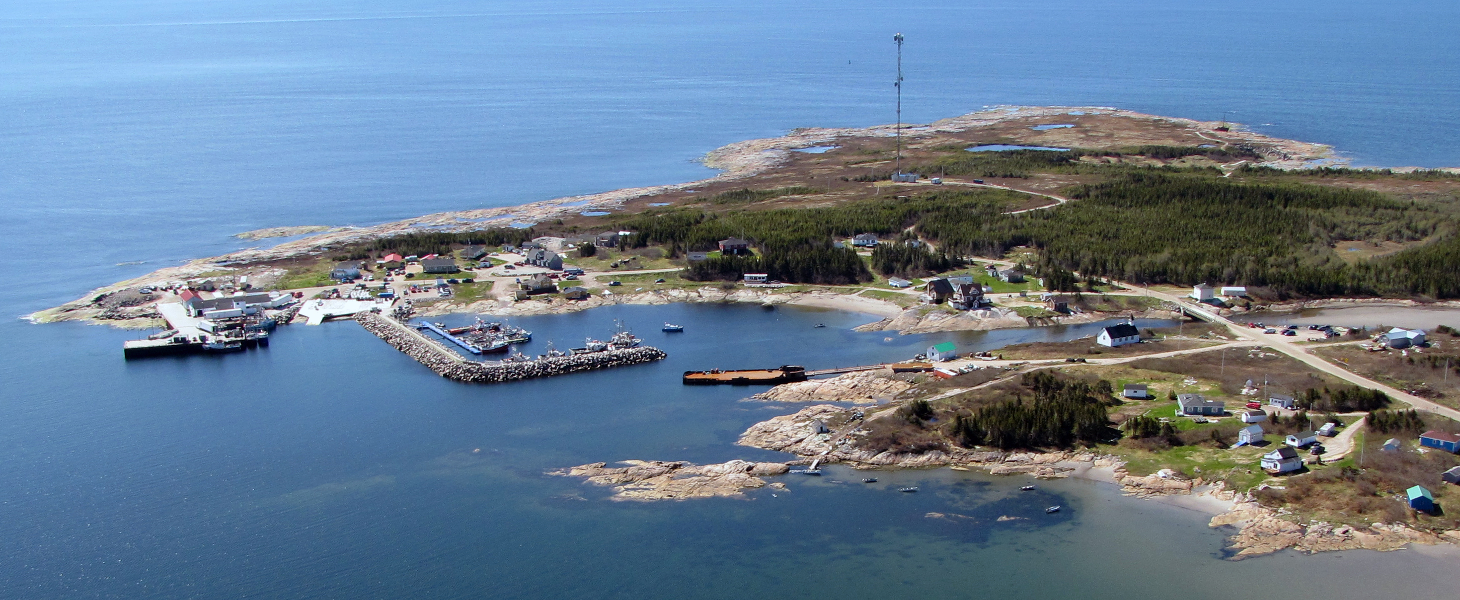
Chapter 1 — In the vicinity of paragraphs 48 and 56
Replace the KEGASKA (2009) photograph with the
photograph KEGASKA (2018).
https://www.notmar.gc.ca/publications/monthly-mensuel/images/ed0220-sec4-atl110-KEGASKA_2018.jpg
(Q2020-001.4)
Chapter 4 — Paragraph 64
Delete: “There is a landing pier and floating docks.”
(Q2020-002.1)
Chapter 3 — Paragraph 33, after “on the ferry and the river banks.”
Add:There is a wreck at the bottom of the river, on the west side, approximately 0.6 miles north of the Coderre Stream.
(Q2019-073.1)
Chapter 1 — Paragraph 204
Delete: 132 feet (40 m)
Replace by: 58 m
(C2020-002.01)
Chapter 1 — Paragraph 204, after ‘…(40 m) high…’
Delete: (not shown on the chart)
(C2020-001.02)
Chapter 1 — Paragraph 204, after ‘…prominent flagpole…’
Delete: (not shown on the chart)
(C2020-001.03)
Chapter 1 — Paragraph 248, after ‘…(0.3 to 1.5 m) (1995)’
Insert: was in ruins in 2019.
(C2020-001.04)
Chapter 1 — Paragraph 282
Delete: Woman
Replace by: Woman’s
(C2020-001.05)
Chapter 1 — Paragraph 283
Delete: Woman
Replace by: Woman’s
(C2020-001.06)
INDEX — After Old Woman Bay, C4/P152
Delete: Old Woman River, C1/P282
Replace by: Old Woman’s River, C1/P282
(C2020-001.07)
Chapter 9 — Paragraph 134, after “clearance of”
Delete: 6.2 m
Replace by: 6.0 m
(Q2019-025.1)
Chapter 9 — Paragraph 136, after “clearance of”
Delete: 6.7 m
Replace by: 6.0 m
(Q2019-025.2)
Chapter 9 — Delete paragraph 141.
(Q2019-025.3)
Chapter 9 — Paragraph 142, after “a clearance of 8.5 m..”
Delete: “An area for water-skiing … in Saraguay.”
(Q2019-025.4)
APPENDIX — Table of marine facilities* — CHAPTER 9
Delete all information pertaining to Marina de Pierrefonds.
(Q2019-025.5)
SECTION 5 - LIST OF LIGHTS, BUOYS AND FOG SIGNALS CORRECTIONS
The amendments are highlighted and deletions are crossed out. For general and region-specific
information on the List of Lights, click on the following links:
Newfoundland and Labrador Coast,
Atlantic Coast,
Inland Waters and
Pacific Coast.
NEWFOUNDLAND AND LABRADOR COAST
| No. | Name |
Position ----- Latitude N. Longitude W. |
Light Characteristics |
Focal Height in m. above water |
Nominal Range |
Description ----- Height in meters above ground |
Remarks ----- Fog Signals |
|||
|---|---|---|---|---|---|---|---|---|---|---|
STRAIT OF BELLE ISLE (LL 211 – 234) |
||||||||||
|
228.3 |
L’Anse-au-Diable light buoy ND2 |
At
entrance. 51 33 25.2 056 45 35.5 |
Fl | R | 4s | ..... | ..... | Red spar, marked “ND2”. |
Seasonal. Chart:4020 Edn 02/20 (N20-003) |
|
|
228.4 |
L’Anse-au-Diable light buoy ND1 |
At
entrance. 51 33 25.1 056 45 39.9 |
Fl | G | 4s | ….. | ….. | Green spar, marked “ND1”. |
Seasonal. Chart:N/A Edn 02/20 (N20-002) |
|
ATLANTIC COAST
| No. | Name |
Position ----- Latitude N. Longitude W. |
Light Characteristics |
Focal Height in m. above water |
Nominal Range |
Description ----- Height in meters above ground |
Remarks ----- Fog Signals |
|||
|---|---|---|---|---|---|---|---|---|---|---|
BAY OF FUNDY, N.S. (LL 163 – 268) |
||||||||||
|
171 H3950 |
Cape Sharp |
On S. extremity of cape. 45 21 52.2 064 23 31.5 |
LFl | W | 6s | 17.4 | 11 |
White pyramid tower
with red
top. 11.7 |
Flash 2 s;
eclipse 4
s. Operates 24 h. Year round. Horn - Blast 4 s; sil. 56 s. Horn points 250°. Mariners requiring the operation of the fog signal will have to select VHF channel 65 and key their microphones five (5) times within 10 seconds. The fog signal will be in operation for 15 minutes. The fog signal can be activated within a 1 NM distance. The fog signal can be activated for another 15 minutes by repeating the above procedure. Chart:4399 Edn 02/20 (F19-044) |
|
NOVA SCOTIA, SOUTHWEST COAST (LL 271 – 300.5) |
||||||||||
|
295 H3800 |
Whitehead Island |
On S. point of island. 43 39 45.8 065 52 02.6 |
Fl | G | 15s | 30.0 | 10 |
Red and
white rectangular tower with red top. 11.9 |
Flash 1 s; eclipse 14 s. Year round. Horn - Blast 3 s; sil. 27 s. Omnidirectional. Chart:4244 Edn 02/20 (F19-042) |
|
NOVA SCOTIA AND CAPE BRETON ISLAND (LL 686.5 – 704.1) |
||||||||||
|
701 H3436 702 H3436.1 |
Balache Point range |
| | | | | | | | | | | | |
N. end of Canso Lock. 45 38 57.7 061 24 59.4 131°30' 219.84 m from front. |
Oc Oc |
R R |
11s 11s |
6.0 13.0 |
….. ….. |
Square skeleton tower, white 3.5 White square tower 7.5 |
Flash 10 s; eclipse 1 s. Visible in line of range. Operates 24 h. Seasonal. Flash 10 s; eclipse 1 s. Visible in line of range. Operates 24 h. Seasonal. Chart:4302 Edn 02/20 (G19-139, 140, 141) |
GULF OF ST. LAWRENCE (LL 883.2 – 940.3, 1169.1 – 1426, 1477.5 – 1584) |
||||||||||
|
1373.3 H1665 |
Paspébiac Breakwater |
On outer end of breakwater. 48 01 06.1 065 15 34.3 |
Fl | G | 6s | 10.7 | 7 |
Square skeleton tower. 8.1 |
Flash 1 s; eclipse 5 s. Year round. Chart:4921 Edn 02/20 (Q20-002) |
|
|
1374 H1666 |
Paspébiac Wharf |
On W. end of wharf. 48 01 08.0 065 15 29.1 |
Fl | R | 6s | 9.6 | 6 |
Pipe swing pole. 6.5 |
Flash 1 s; eclipse 5 s. Year round. Chart:4921 Edn 02/20 (Q20-003) |
|
PRINCE EDWARD ISLAND (LL 942 – 1084.7) |
||||||||||
|
1008.1 H1036 |
Victoria Harbour |
Delete from
list. Chart:4405 Edn 02/20 (G19-116) |
||||||||
| 1008.2 | Victoria Harbour Wharf light |
46 12
44.7 063 29 20.3 |
Fl | G | 4s | ….. | 6 | Pipe swing pole, green-white-black square daymark. |
Flash 1 s; eclipse
3 s. Seasonal. Chart:4405 Edn 02/20 (G19-119) |
|
|
1025.5 H1057.5 |
Fishing Cove West Breakwater |
On S. end of W. breakwater. 46 24 26.1 064 08 06.7 |
Fl | G | 4s | 3.2 | 4 |
Cylindrical mast. 2.8 |
Flash 1 s; eclipse
3 s. Seasonal. Chart:4406 Edn 02/20 (G19-146) |
|
| 1046.06 | St. Peters Harbour light buoy JD12 |
46 26 44.4 062 44 16.0 |
Fl | R | 4s | ….. | ….. | Red, marked “JD12”. |
Buoy may be repositioned due to shifting channel. Seasonal. Chart:N/A Edn 02/20 (G19-135) |
|
CANADIAN COAST GUARD - MARINE INFORMATION REPORT AND SUGGESTION SHEET
Name of Ship or Sender:..................................................................... Date:....................................
Address of Sender:..........................................................................................................................
Street # Street Name
Town / City:.............................. Prov / State:....................... Postal Code / Zip Code: ........................
Tel / Fax / E-mail address of sender (if appropriate):............................................................................
Observation Date:............................................. Time (UTC): ...........................................................
Geographical Position:......................................................................................................................
Coordinate Position: Lat: ............................................... Long:.........................................................
Position Method: DGPS GPS with WAAS GPS Radar Other
Horizontal Datum Used: WGS 84 NAD 27 Other
Estimated Position Accuracy:............................................................................................................
Chart #:............................................................ Datum: NAD 27 NAD 83
Chart Edition:.................................................... Last Correction applied:............................................
Publications affected: (Quote edition and page number):.....................................................................
*Full details (Attach additional sheets as necessary):...........................................................................
Mariners are requested to notify the responsible authorities when new or suspected dangers to navigation are discovered, changes are observed in aids to navigation, or corrections to publications are seen to be necessary.
In the case of new or suspected dangers to navigation, it is important that all details be given in order to aid with future investigations. Items of interest include heights, depths, physical description, type of bottom and equipment method used to position the item. It is helpful to mark details on the chart, which will be promptly replaced by the Canadian Hydrographic Service.
Reports should be made to the nearest Marine Communications and Traffic Services Centre (MCTS) and should be confirmed in writing to:
Leader, Notices to Mariners
Canadian Coast Guard
Department of Fisheries and Oceans
Montréal, QC H2Y 2E7
In the case of information concerning aids to navigation or the List of Lights, Buoys and Fog Signals book.
OR
Director General, Canadian Hydrographic Service & Oceanographic Services
Department of Fisheries and Oceans
Ottawa, ON K1A 0E6
In the case of new or suspected dangers to navigation or where corrections to "Sailing Directions" appear to be necessary.
For general questions on Canadian Coast Guard programs or services, please send an e-mail to:
info@dfo-mpo.gc.ca (Please include your postal code and e-mail address).
You can access the online form on the following page: https://www.notmar.gc.ca/incident-en.php or you can use the printable pdf version : https://www.notmar.gc.ca/publications/monthly-mensuel/images/monthly-form-en.pdf