
Archived information
The Standard on Web Usability replaces this content. This content is archived because Common Look and Feel 2.0 Standards have been rescinded.
Archived information is provided for reference, research or recordkeeping purposes. It is not subject to the Government of Canada Web Standards and has not been altered or updated since it was archived.
NOTICES TO MARINERS
PUBLICATION
WESTERN EDITION
May 29, 2020

Safety First, Service Always
Published Monthly by the
CANADIAN COAST GUARD
www.notmar.gc.ca/subscribe/
CONTENTS
| Section 1 | General and Safety Information |
| Section 2 | Chart Corrections |
| Section 3 | Radio Aids to Marine Navigation Corrections |
| Section 4 | Sailing Directions and Small Craft Guide Corrections |
| Section 5 | List of Lights, Buoys and Fog Signals Corrections |
Canadian Coast Guard Programs
Aids to Navigation and Waterways
Fisheries and Oceans Canada
Montreal, Quebec
H2Y 2E7
© Her Majesty the Queen in Right of Canada, 2020
Fs152-6E-PDF
ISSN 1719-7708
Disponible en français :
Publication des Avis aux navigateurs
Édition de l'Ouest
Édition mensuelle Nº05/2020
Fisheries and Oceans Canada
Official Publication of the Canadian Coast Guard
EXPLANATORY NOTES
Geographical positions refer directly to the graduations of the largest scale Canadian Hydrographic chart unless otherwise indicated.
Bearings refer to the true compass and are measured clockwise from 000° (North) clockwise to 359°; those relating to lights are from seaward.
Visibility of lights is that in clear weather.
Depths - The units used for soundings (metres, fathoms or feet) are stated in the title of each chart.
Elevations are normally given above Higher High Water, Large Tide unless otherwise indicated.
Distances may be calculated as follows:
1 nautical mile = 1,852 metres (6,076.1 feet)
1 statute mile = 1,609.3 metres (5,280 feet)
1 metre = 3.28 feet
Temporary & Preliminary Notices are indicated by a (T) or a (P) in Section 1, respectively. Please note that Nautical charts are not amended by the Canadian Hydrographic Service for Temporary (T) and Preliminary (P) Notices. It is recommended that mariners chart these corrections in pencil. The list of charts affected by Temporary and Preliminary Notices are revised and promulgated quarterly in Section 1 of the Monthly Edition.
Please note that, in addition to the temporary and preliminary changes normally advertised as (T) and (P) Notices, there are a few permanent changes to aids to navigation that have been advertised as Preliminary Notices to Mariners while charts are being updated for new editions.
Marine Information Report & Suggestion Sheet
Mariners are requested to notify the responsible authorities when new or suspected dangers to navigation are discovered, changes observed in aids to navigation or corrections to publications are seen
to be necessary. Such communications can be made using the Marine Information Report & Suggestion Sheet inserted on the last
page of each monthly edition of Notices to Mariners.
Canadian Hydrographic Service - Information Published in Section 2 of Notices to Mariners
Mariners are advised that only the most critical changes that directly affect safety to navigation are issued in Section 2 – Chart Corrections. This limitation
is required to ensure that charts remain as clear and easy to read as possible. As a result, mariners may see minor discrepancies of a
non-critical nature between information in official publications. For example, a small change in the nominal range or focal height of a light
may not result in the production of a chart correction in Notices to Mariners, but may result in a correction in the List of Lights, Buoys and
Fog Signals publication.
In case of discrepancy between information provided on CHS charts relating to aids to navigation, and the List of Lights, Buoys and Fog Signals publication, the latter shall be deemed as containing the most up-to-date information.
Canadian Nautical Charts & Publications
A source list of Canadian nautical charts and publications is published in Notice No. 14 of the Notices to Mariners Annual Edition 2020. The source supply and the prices
effective at the time of printing are listed. For current chart edition dates, please refer to the following website:
www.chs-shc.gc.ca/charts-cartes/paper-papier/index-eng.asp
CHART CORRECTIONS - SECTION 2
Corrections to nautical charts will be listed in numerical order by chart number. Each chart correction listed applies only to that particular chart. Related charts, if any, will have their own specific correction listed separately.
Users should also refer to CHS Chart 1: Symbols, Abbreviations and Terms for additional information pertaining to the correction of charts.
The illustration below describes the elements that will comprise a typical Section 2 chart correction:

The last correction number is identified with the LNM/D or Last Notice to Mariners Number / Date.
NOTICES TO MARINERS WEBSITE – MONTHLY EDITIONS, CHART CORRECTIONS, AND CHART PATCHES
The Notices to Mariners website allows users to access the monthly publications,
chart corrections, and chart patches.
Users can subscribe for free to the email notification service
to receive notifications when charts of interest are updated, including their patches, as well as when a new monthly edition becomes available online.
In addition, the monthly publication and related files to download, such as chart patches and Sailing Directions diagrams, can be obtained all together through the download of a single ZIP file.
ADVISORY NAVIGATIONAL WARNINGS / NOTICES TO SHIPPING
The Canadian Coast Guard is implementing a number of changes to the aids to navigation system in Canada.
These changes are advertised as Navigational Warnings, formerly called Notices to ShippingFootnote 1, that are broadcast by the Canadian Coast Guard, and are then followed up with Notices to Mariners, then charts are updated by hand correction, reprints or new editions.
Mariners are advised that all relevant Navigational Warnings (NAVWARNs) should be kept until superseded by Notices to Mariners or through revised charts issued by the Canadian Hydrographic Service (CHS).
Navigational Warnings are accessible on the applicable regional page on the Canadian Coast Guard e-Navigation Maritime Information Portal at http://www.marinfo.gc.ca/e-nav.
The Canadian Hydrographic Service is reviewing the impact of these changes with the Canadian Coast Guard and together are preparing an action plan on the issuing of chart revisions.
For further information, contact your regional Navigational Warning (NAVWARN) Issuing Desk.
Western Region
Prince Rupert MCTS Centre
Canadian Coast Guard
Bag 4444
Prince Rupert, BC V8J 4K2
Telephone: (250) 627-3070
Email: NAVWARN.MCTSPrinceRupert@innav.gc.ca
Website: http://www.marinfo.gc.ca/e-nav
Central & Arctic Region
* Iqaluit MCTS Centre
Operational from approximately mid-May until late December.
Canadian Coast Guard
P.O. Box 189
Iqaluit, NU X0A 0H0
“A” Series
Telephone: (867) 979-5269
“H” Series
Telephone: (867) 979-0310
Facsimile: (867) 979-4264
Email: NAVWARN.MCTSIqaluit@innav.gc.ca
Website: http://www.marinfo.gc.ca/e-nav
* Service available in English and French.
Index
NUMERICAL INDEX OF CANADIAN CHARTS AFFECTED
| 1316 | 3495 | 3671 | 6213 |
| 1317 | 3515 | 3910 | 6215 |
| 3313 | 3564 | 3912 | 6216 |
| 3441 | 3602 | 3938 | 6218 |
| 3462 | 3606 | 3939 | 6286 |
| 3477 | 3646 | 3940 | 6424 |
| 3492 | 3668 | 6109 |
SECTION 1 - GENERAL AND SAFETY INFORMATION
CANADIAN COAST GUARD PUBLICATION – COMMENTS AND SUGGESTIONS ON NOTICES TO MARINERS (NOTMAR) PUBLICATIONS
In an effort to continuously improve the Notices to Mariners publications and to provide the most efficient service possible, the Notices to Mariners team invites all mariners and other interested parties to submit comments and suggestions on possible improvements to its various publications and services at the following email address: Notmar.XNCR@dfo-mpo.gc.ca
CANADIAN HYDROGRAPHIC SERVICE – MODIFICATIONS TO THE 2020 CANADIAN TIDE AND CURRENT TABLES VOLUME 5 – JUAN DE FUCA STRAIT AND STRAIT OF GEORGIA
(Recurrent publication of notice *204/20, originally published in the Notices to Mariners Publication - Western Edition 02/2020.)
The Canadian Hydrographic Service of the Pacific Region has recently been informed of an error in the 2020 Canadian Tide and Current Tables, Volume 5 - Juan de Fuca Strait and Strait of Georgia, page 123, Table 2, Index no. 7120 – VICTORIA.
Mariners should replace the values for Victoria, Index no. 7120 using the attached Table 2 for page 123:
https://www.notmar.gc.ca/publications/monthly-mensuel/images/ed022020-part1-vol5-p123.pdf
TRANSPORT CANADA – COVID-19 MEASURES, UPDATES AND GUIDANCE
(Recurrent publication of notice *401/20, originally published in the Notices to Mariners Publication - Western Edition 04/2020.)
Please refer to the link below for the latest updates to transportation related measures taken by Transport Canada in response to the evolving novel Coronavirus disease (COVID-19):
https://www.tc.gc.ca/en/initiatives/covid-19-measures-updates-guidance-tc.html
For travel advice and all other updates, please visit: Canada.ca/coronavirus
*501CANADIAN HYDROGRAPHIC SERVICE – NAUTICAL CHARTS
|
CHARTS |
MAIN TITLE |
SCALE |
PUBLISHED |
CAT# |
PRICE |
|
New Editions |
|
|
|
|
|
|
1316 |
Port de Québec |
1:15 000 |
03-APR-2020 |
1 |
20.00 |
|
1317 |
Sault-au-Cochon à/to Québec |
1:50 000 |
03-APR-2020 |
1 |
20.00 |
|
6213 |
Whitefish Bay |
1:40 000 |
28-FEB-2020 |
3 |
19.95 |
|
6215 |
Basil Channel to/à Sturgeon Channel |
1:40 000 |
28-FEB-2020 |
3 |
19.95 |
|
6216 |
Sturgeon Channel to/à Big Narrows Island |
1:40 000 |
28-FEB-2020 |
3 |
19.95 |
|
6218 |
Kenora, Rat Portage Bay |
1:15 000 |
28-FEB-2020 |
3 |
19.95 |
|
6286 |
Whitedog Dam to/à Minaki |
1:25 000 |
17-APR-2020 |
3 |
19.95 |
*502CANADIAN HYDROGRAPHIC SERVICE – RASTER DIGITAL CHARTS (BSB V3)
|
CHARTS |
MAIN TITLE |
SCALE |
PUBLISHED |
|
New Editions |
|
|
|
|
RM-1316 |
Port de Québec |
1:15 000 |
03-APR-2020 |
|
RM-1317 |
Sault-au-Cochon à/to Québec |
1:50 000 |
03-APR-2020 |
|
RM-6213 |
Whitefish Bay |
1:40 000 |
28-FEB-2020 |
|
RM-6215 |
Basil Channel to/à Sturgeon Channel |
1:40 000 |
28-FEB-2020 |
|
RM-6216 |
Sturgeon Channel to/à Big Narrows Island |
1:40 000 |
28-FEB-2020 |
|
RM-6218 |
Kenora, Rat Portage Bay |
1:15 000 |
28-FEB-2020 |
|
RM-6286 |
Whitedog Dam to/à Minaki |
1:25 000 |
17-APR-2020 |
*503TRANSPORT CANADA – SHIP SAFETY BULLETIN #13/2020
A new Ship Safety Bulletin has recently been posted to the Transport Canada website at www.tc.gc.ca/ssb-bsn/.
To view or download this bulletin, please click on the link below:
SSB#13/2020 – Temporary Measures
Regarding Marine Personnel Certificates, Discharge Books and
Marine Counter Services
RDIMS#16427138
Sign yourself up for e-Bulletin to receive an e-mail notice each time a new Ship Safety Bulletin is published on our website.
Contact us at marinesafety-securitemaritime@tc.gc.ca or 1-855-859-3123 (Toll Free).
*505ANGUNIAQVIA NIQIQYUAM MARINE PROTECTED AREA (ANMPA) AND TARIUM NIRYUTAIT MARINE PROTECTED AREAS (TNMPA) – BELUGA AND BOWHEAD WHALE PROTECTION: VOLUNTARY AVOIDANCE AND SLOWDOWN AREAS
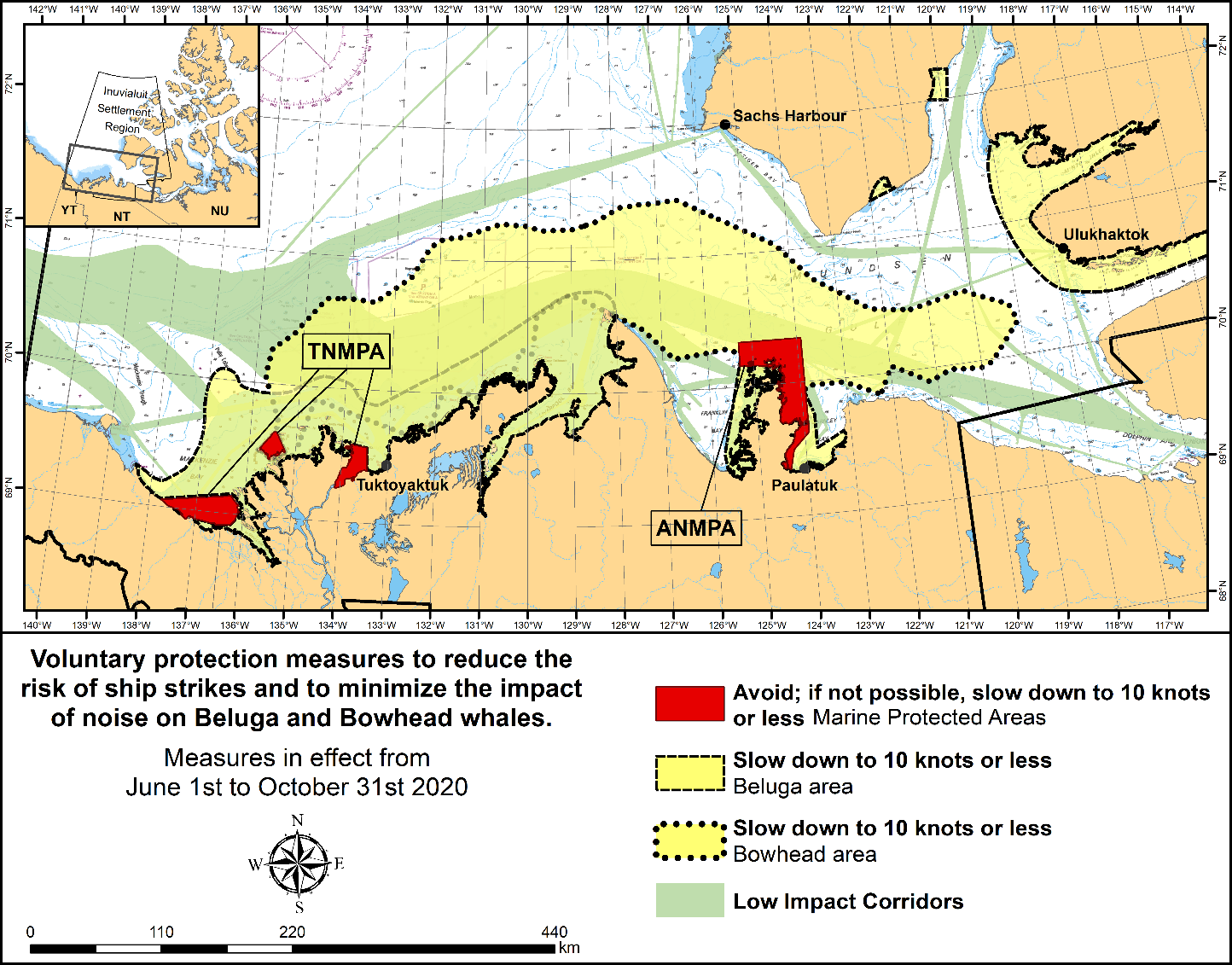
The two established Marine Protected Areas (MPAs) in Canada’s Western Arctic are located within the Inuvialuit Settlement Region, as such all activities must comply with the Inuvialuit Final Agreement. Protection and preservation of Arctic wildlife, the environment and biological productivity is one of the principles of the Inuvialuit Final Agreement and it is this principle that led the Inuvialuit Regional Corporation and the Inuvialuit Game Council to initiate establishment of the Western Arctic MPAs. The waters in and near the MPAs, and the offshore marine habitats of the Beaufort Sea and Amundsen Gulf, are important summer foraging habitats used seasonally (May-October) by the Eastern Beaufort Sea beluga stock, and the Bering-Chukchi-Beaufort bowhead population.
REGULATORY PROTECTION MEASURES
All whale species are protected under the Marine Mammal Regulations, pursuant to the Fisheries Act. Within the boundaries of the MPAs, a general prohibition is set out in the Regulations, pursuant to the Oceans Act. Any incident with a marine mammal within the MPAs must be reported within two hours after its occurrence, to the Canadian Coast Guard. For marine wildlife sightings and incidents such as collisions that occur outside the MPAs or for any situation involving a marine mammal that is dead or in trouble, contact Fisheries and Oceans Canada, Inuvik office at (867) 777-7500.
For more information on the ANMPA and TNMPA, including local contacts and species specific minimum distances, see Section A2 - Notices 5 and 5A.3 of the Notices to Mariners Annual Edition 2020.
VOLUNTARY PROTECTION MEASURES
Voluntary measures are in effect from June 1st to October 31st, 2020. See map above.
These measures apply to merchant vessels, cruise ships, small vessels and adventure craft within the boundaries of the MPAs and the additional identified areas to prevent collisions with whales and to mitigate the underwater noise generated by the vessels. These measures should only be taken when they will not jeopardize navigational safety.
Avoid (red area): To reduce the risk of underwater noise disturbance and collisions with whales within the MPAs, vessels should avoid transiting through the MPAs if possible. If passage through this area is required, vessels should slow down to a maximum speed through the water of 10 knots and post a lookout such as a marine mammal observer in order to increase the chances of seeing the whales and thus taking necessary measures to avoid them. If bypassing the whales is not possible, slow down and wait for the animals to move away to a distance greater than 400 metres (0.215 nautical miles) before resuming original speed up to 10 knots. It is more difficult to see the animals in rain, fog, or in rough sea states, therefore increased caution is recommended.
Slow down to 10 knots or less (yellow area): To reduce the risk of underwater noise disturbance and collisions with whales within this area, it is recommended that vessels should slow down to a maximum speed through the water of 10 knots, remain in the navigation and marked community supply channels and post a lookout.
These voluntary measures are secondary to rights under the Inuvialuit Final Agreement.
MPA Coordinates
The Tarium Niryutait Marine Protected Areas consist of three areas of the Mackenzie Bay: Okeevik, Kittigaryuit and Niaqunnaq. The three areas are bounded by rhumb lines connecting the following geographical coordinates [North America Datum 1983 (NAD 83)/World Geodetic System (WGS 84)].
Okeevik Sub Area
|
Point |
Latitude (North) |
Longitude (West) |
|
1 |
69° 38’ 19” |
135° 25’ 09” |
|
2 |
69° 38’ 03” |
135° 25’ 11” |
|
3 |
69° 37’ 46” |
135° 24’ 52” |
|
4 |
69° 29’ 49” |
135° 12’ 49” |
|
5 |
69° 30’ 45” |
135° 16’ 56” |
|
6 |
69° 29’ 26” |
135° 18’ 53” |
|
7 |
69° 29’ 23” |
135° 19’ 06” |
|
8 |
69° 28’ 07” |
135° 20’ 25” |
|
9 |
69° 27’ 36” |
135° 24’ 25” |
|
10 |
69° 25' 51” |
135° 32’ 27” |
|
11 |
69° 26’ 32” |
135° 34’ 54” |
|
12 |
69° 28’ 21” |
135° 35’ 24” |
|
13 |
69° 28’ 35” |
135° 36’ 40” |
|
14 |
69° 28’ 39” |
135° 37’ 58” |
|
15 |
69° 30’ 34” |
135° 45’ 54” |
|
16 |
69° 35’ 18” |
135° 35’ 42” |
|
17 |
69° 36’ 00” |
135° 22’ 10” |
|
18 |
69° 34’ 40” |
135° 20’ 09” |
|
19 |
69° 34’ 00” |
135° 20’ 09” |
|
20 |
69° 34’ 00” |
135° 27’ 39” |
|
21 |
69° 36’ 00” |
135° 27’ 39” |
|
22 |
69° 27’ 00” |
135° 31’ 11” |
|
23 |
69° 27’ 00” |
135° 34’ 45” |
Kittigaryuit Sub Area
|
Point |
Latitude (North) |
Longitude (West) |
|
1 |
69° 35’ 10” |
133° 48’ 26” |
|
2 |
69° 34’ 00” |
133° 28’ 00” |
|
3 |
69° 23’ 37” |
133° 26’ 40” |
|
4 |
69° 20’ 34” |
133° 40’ 37” |
|
5 |
69° 19’ 05” |
133° 42’ 21” |
|
6 |
69° 19’ 01” |
133° 42’ 31” |
|
7 |
69° 20’ 39” |
133° 43’ 20” |
|
8 |
69° 16’ 42” |
133° 54’ 54” |
|
9 |
69° 15’ 20” |
134° 06’ 53” |
|
10 |
69° 16’ 33” |
134° 05’ 56” |
|
11 |
69° 20’ 42” |
134° 02’ 44” |
|
12 |
69° 24’ 00” |
133° 59’ 10” |
|
13 |
69° 24’ 34” |
133° 53’ 49” |
|
14 |
69° 28’ 21” |
133° 48’ 15” |
|
15 |
69° 28’ 02” |
133° 50’ 59” |
|
16 |
69° 33’ 20” |
133° 47’ 29” |
|
17 |
69° 34’ 33” |
133° 47’ 42” |
|
18 |
69° 32’ 55” |
133° 51’ 09” |
|
19 |
69° 32’ 56” |
133° 51’ 54” |
|
20 |
69° 33’ 46” |
133° 55’ 48” |
|
21 |
69° 33’ 46” |
133° 55’ 31” |
Niaqunnaq Sub Area
|
Point |
Latitude (North) |
Longitude (West) |
|
1 |
69° 08’ 00” |
136° 16’ 44” |
|
2 |
69° 04’ 25” |
136° 07’ 45” |
|
3 |
69° 03’ 43” |
136° 07’ 08” |
|
4 |
69° 01’ 19” |
136° 04’ 45” |
|
5 |
69° 01’ 14” |
136° 04’ 45” |
|
6 |
69° 00’ 57” |
136° 05’ 42” |
|
7 |
69° 00’ 12” |
136° 07’ 08” |
|
8 |
68° 57’ 00” |
136° 10’ 00” |
|
9 |
68° 55’ 00” |
136° 15’ 00” |
|
10 |
68° 54’ 22” |
136° 31’ 50” |
|
11 |
68° 55’ 00” |
136° 38’ 33” |
|
12 |
68° 56’ 15” |
137° 00’ 41” |
|
13 |
68° 56’ 29” |
137° 03’ 03” |
|
14 |
68° 55’ 48” |
137° 11’ 00” |
|
15 |
68° 57’ 50” |
137° 16’ 40” |
|
16 |
68° 59’ 20” |
137° 21’ 30” |
|
17 |
69° 03’ 09” |
137° 44’ 54” |
The Anguniaqvia niqiqyuam Marine Protected Areas consist of two areas in Darnley Bay and Amundsen Gulf in the Beaufort Sea: Zone 1 and Zone 2. The areas consist of the seabed, the subsoil to a depth of five metres and the water column, including the sea ice. The two areas are bounded by straight lines connecting the following geographical coordinates [North America Datum 1983 (NAD 83)].
Zone 1
|
Point |
Latitude (North) |
Longitude (West) |
|
A |
69° 21’ 07.8” |
124° 21’ 32.0” approx |
|
B |
70° 12’ 00.0” approx |
124° 31’ 55.2” |
|
C |
70° 08’ 22.0” |
124° 41’ 45.0” approx |
|
D |
70° 09’ 09.9” |
124° 57’ 42.0” approx |
|
E |
70° 09’ 13.0” approx |
125° 05’ 28.6” |
|
F |
70° 09’ 13.2” |
125° 17’ 53.0” |
|
G |
70° 20’ 00.0” |
125° 17’ 53.0” |
|
H |
70° 20’ 00.0” |
123° 54’ 17.5” |
|
I |
69° 37’ 20.6” |
123° 54’ 17.5” |
|
J |
69° 30’ 00.0” |
124° 15’ 34.7” |
Zone 2
|
Point |
Latitude (North) |
Longitude (West) |
|
K |
70° 04’ 15.8” |
124° 41’ 51.0” approx |
|
L |
70° 04’ 48.6” |
124° 41’ 54.0” approx |
|
M |
70° 02’ 12.9” |
124° 35’ 23.0” approx |
|
N |
70° 02’ 12.9” |
124° 35’ 29.0” approx |
*507CANADIAN COAST GUARD PUBLICATION – AMENDMENTS TO NOTICES TO MARINERS ANNUAL EDITION 2020 - SECTION A2, NOTICE 5: GENERAL GUIDELINES FOR AQUATIC SPECIES AT RISK AND IMPORTANT MARINE MAMMAL AREAS
Several amendments have been made throughout this notice. The latest version of this notice can be found at the following link:
https://www.notmar.gc.ca/publications/annual-annuel/section-a/a5-en.pdf
*508CANADIAN COAST GUARD PUBLICATION – AMENDMENTS TO NOTICES TO MARINERS ANNUAL EDITION 2020 - SECTION A3, NOTICE 6: ICE NAVIGATION, ROUTEING AND REQUESTS FOR ICEBREAKER ASSISTANCE
Page 3:
AMEND
(b)For general information on ice conditions and icebreaker assistance in Chaleur Bay, New Brunswick, Prince Edward Island, Nova Scotia and Newfoundland and Labrador waters:
|
Telephone: |
709-772-2078 |
|
Toll-Free: |
1-800-565-1633 |
|
Facsimile: |
709-772-6640 (Business hours only) |
|
Email (24 hour assistance): |
|
|
Email (general inquiries): |
TO READ
(b)For general information on ice conditions and icebreaker assistance in Chaleur Bay, New Brunswick, Prince Edward Island, Nova Scotia and Newfoundland and Labrador waters:
|
Telephone: |
709-772-2078 |
|
Toll-Free: |
1-800-565-1633 |
|
Facsimile: |
709-772-6640 (Business hours only) |
|
Email (24 hour assistance): |
|
|
Email (general inquiries): |
*510(P)KNIGHT INLET – DAYBEACON TO BE DISCONTINUED
Reference Chart: 3515
The Canadian Coast Guard proposes to permanently discontinue the following aid to navigation:
|
Irvine Point port daybeacon |
(LL 5348) |
(50° 49’ 20.8”N 126° 13’ 46.4”W) |
Comments on this action are solicited from mariners and other interested parties by August 28, 2020, three months following the initial publication date of May 29, 2020. Following this date, this notice will be cancelled. Comments should be directed to the following:
A/Superintendent, Glenna Evans
Aids to Navigation & Waterways, Western Region
Canadian Coast Guard
25 Huron Street
Victoria, BC V8V 4V9
Telephone: (250) 480-2602
Fax: (250) 480-2702
Email: glenna.evans@dfo-mpo.gc.ca
Any objections raised must state the facts on which they are based and should include supporting information on safety, commerce and public benefit.
(P2020-036)
*511(P)PLANS - JOHNSTONE STRAIT – DAYBEACON TO BE DISCONTINUED
Reference Chart: 3564
The Canadian Coast Guard proposes to permanently discontinue the following aid to navigation:
|
Lily Islet starboard daybeacon |
(LL 5343) |
(50° 31’ 53.8”N 126° 15’ 24.6”W) |
Comments on this action are solicited from mariners and other interested parties by August 28, 2020, three months following the initial publication date of May 29, 2020. Following this date, this notice will be cancelled. Comments should be directed to the following:
A/Superintendent, Glenna Evans
Aids to Navigation & Waterways, Western Region
Canadian Coast Guard
25 Huron Street
Victoria, BC V8V 4V9
Telephone: (250) 480-2602
Fax: (250) 480-2702
Email: glenna.evans@dfo-mpo.gc.ca
Any objections raised must state the facts on which they are based and should include supporting information on safety, commerce and public benefit.
(P2020-035)
*512ROBERTS BANK – FLASH CHARACTERISTICS UNCHANGED
Reference: Notice 1115(P)/19 is cancelled (Chart 3492)
The Canadian Coast Guard’s proposal to change the flash
characteristics of the Roberts Bank Entrance range
(LL 307.91 / LL 307.92) from Q1s Yellow to Fixed Yellow has
been cancelled.
The flash characteristics will remain Q1s Yellow.
(P2020-037)
SECTION 2 - CHART CORRECTIONS
3313 - Plumper Sound - Sheet/Feuille 11 - New Edition - 02-JAN-2009 - NAD 1983
Zone de Restriction des Épaulards En vigueur du 1er juin au 30 novembre. Pour plus de renseignements voir Avis Annuel Aux Navigateurs A2 Section 5.
3313 - Saanich Inlet - Sheet/Feuille 13 - New Edition - 02-JAN-2009 - NAD 1983
(See Chart No. 1, L30.1)
48°39′04.0″N 123°27′07.0″W
48°39′07.0″N 123°27′17.0″W
48°39′04.0″N 123°28′20.0″W
48°39′03.0″N 123°29′12.0″W
48°37′47.0″N 123°29′17.0″W
and 48°37′20.0″N 123°29′56.0″W
(See Chart No. 1, L30.1)
48°39′04.4″N 123°27′07.2″W
48°39′07.2″N 123°27′25.8″W
48°39′04.2″N 123°28′14.3″W
48°39′03.2″N 123°29′12.1″W
48°37′47.7″N 123°29′20.6″W
48°37′30.7″N 123°30′10.1″W
and 48°37′20.2″N 123°29′56.0″W
(See Chart No. 1, L30.1)
48°38′57.1″N 123°28′51.9″W
and 48°38′58.2″N 123°28′32.8″W
(See Chart No. 1, K40)
3313 - Boundary Pass - Sheet/Feuille 24 - New Edition - 02-JAN-2009 - NAD 1983
Zone de Restriction des Épaulards En vigueur du 1er juin au 30 novembre. Pour plus de renseignements voir Avis Annuel Aux Navigateurs A2 Section 5.
3441 - Haro Strait, Boundary Pass and/et Satellite Channel - New Edition - 01-JUL-2005 - NAD 1983
(See Chart No. 1, L30.1)
48°39′14.4″N 123°27′19.0″W
48°39′04.5″N 123°28′53.2″W
48°39′04.6″N 123°29′10.9″W
48°37′47.0″N 123°29′17.0″W
and 48°37′20.2″N 123°29′56.0″W
(See Chart No. 1, L30.1)
48°39′04.4″N 123°27′07.2″W
48°39′07.2″N 123°27′25.8″W
48°39′04.2″N 123°28′14.3″W
48°39′03.2″N 123°29′12.1″W
48°37′47.7″N 123°29′20.6″W
48°37′30.7″N 123°30′10.1″W
and 48°37′20.2″N 123°29′56.0″W
(See Chart No. 1, L30.1)
and 48°38′57.0″N 123°28′32.7″W
(See Chart No. 1, L30.1)
48°38′57.1″N 123°28′51.9″W
and 48°38′58.2″N 123°28′32.8″W
Zone de Restriction des Épaulards En vigueur du 1er juin au 30 novembre. Pour plus de renseignements voir Avis Annuel Aux Navigateurs A2 Section 5.
Zone de Restriction des Épaulards En vigueur du 1er juin au 30 novembre. Pour plus de renseignements voir Avis Annuel Aux Navigateurs A2 Section 5.
3462 - Juan de Fuca Strait to/à Strait of Georgia - New Edition - 01-JUL-2005 - NAD 1983
(See Chart No. 1, L30.1)
48°39′14.4″N 123°27′19.0″W
48°39′04.5″N 123°28′53.2″W
48°39′04.6″N 123°29′10.9″W
48°37′47.0″N 123°29′17.0″W
and 48°37′20.2″N 123°29′56.0″W
(See Chart No. 1, L30.1)
48°39′07.2″N 123°27′25.8″W
48°39′03.2″N 123°29′12.1″W
48°37′47.7″N 123°29′20.6″W
48°37′30.7″N 123°30′10.1″W
and 48°37′20.2″N 123°29′56.0″W
3477 - Bedwell Harbour to/à Georgeson Passage - New Edition - 03-MAY-1985 - NAD 1927
Zone de Restriction des Épaulards En vigueur du 1er juin au 30 novembre. Pour plus de renseignements voir Avis Annuel Aux Navigateurs A2 Section 5.
3495 - Vancouver Harbour Eastern Portion/Partie Est - New Edition - 14-DEC-2012 - World Geodetic System 1984
Download Patch - ftp://ftp.dfo-mpo.gc.ca/patches/3495_Patch_NTM20200522.pdf
3602 - Approaches to/Approches à Juan de Fuca Strait - New Edition - 29-NOV-2002 - NAD 1983
Zone de Restriction des Épaulards En vigueur du 1er juin au 30 novembre. Pour plus de renseignements voir Avis Annuel Aux Navigateurs A2 Section 5.
3606 - Juan de Fuca Strait - New Edition - 29-NOV-2002 - NAD 1983
Zone de Restriction des Épaulards En vigueur du 1er juin au 30 novembre. Pour plus de renseignements voir Avis Annuel Aux Navigateurs A2 Section 5.
3646 - Fatty Basin - New Edition - 30-JUN-1995 - NAD 1983
(See Chart No. 1, K11)
(See Chart No. 1, K11)
Recent surveys indicate that horizontal position discrepancies in the order of 25 metres may exist on this chart. Mariners should use caution when navigating in these areas.
DISCORDANCES HORIZONTALES
Des levés récents indiquent que des discordances horizontales de position d′environ 25 mètres existent sur cette carte. Les navigateurs doivent être prudents en naviguant dans ces régions.
3646 - Uchucklesit Inlet - New Edition - 30-JUN-1995 - NAD 1983
(See Chart No. 1, K11)
(See Chart No. 1, K11)
(See Chart No. 1, K11)
(See Chart No. 1, K11)
(See Chart No. 1, N62.2)
3668 - Alberni Inlet - New Edition - 07-APR-2000 - NAD 1983
(See Chart No. 1, I10)
(See Chart No. 1, I10)
(See Chart No. 1, I10)
(See Chart No. 1, I10)
(See Chart No. 1, N62.2)
3668 - Entrance to/Entrée à Useless Inlet - New Edition - 07-APR-2000 - NAD 1983
(See Chart No. 1, I10)
(See Chart No. 1, I10)
(See Chart No. 1, K12)
(See Chart No. 1, I10)
(See Chart No. 1, K11)
3671 - Barkley Sound - New Edition - 04-NOV-2005 - NAD 1983
(See Chart No. 1, I10)
(See Chart No. 1, I10)
(See Chart No. 1, I10)
3910 - Weeteeam Bay - New Chart - 01-APR-2011 - NAD 1983
(See Chart No. 1, K11)
Mariners should exercise caution when navigating these waters as uncharted shoals may exist.
ATTENTION
Les marins doivent être prudents en naviguant dans ces eaux puisque des hauts-fonds non cartographiés peuvent exister.
3912 - Kingkown Inlet - New Edition - 14-AUG-2015 - World Geodetic System 1984
Download Patch - ftp://ftp.dfo-mpo.gc.ca/patches/3912_Patch_NTM20200529.pdf
3938 - Queens Sound to/à Seaforth Channel - New Edition - 15-APR-2016 - World Geodetic System 1984
(See Chart No. 1, Qf, Q130.3)
(See Chart No. 1, I10)
(See Chart No. 1, I10)
(See Chart No. 1, I10)
(See Chart No. 1, I10)
3939 - Fisher Channel to/à Seaforth Channel and/et Dean Channel - New Edition - 01-AUG-2014 - World Geodetic System 1984
(See Chart No. 1, Qf, Q130.3)
(See Chart No. 1, I10)
(See Chart No. 1, I10)
3939 - Shearwater - New Edition - 01-AUG-2014 - World Geodetic System 1984
(See Chart No. 1, I10)
(See Chart No. 1, I10)
6424 - Bryan Island to/à Travaillant River Kilometre 1240 / Kilomètre 1325 - New Edition - 30-JAN-2015 - World Geodetic System 1984
(See Chart No. 1, Qg)
to 67°28′14.2″N 130°55′37.7″W
(See Chart No. 1, Qg)
to 67°27′51.5″N 130°54′17.0″W
(See Chart No. 1, Q120)
(See Chart No. 1, Q120)
(See Chart No. 1, Q120)
(See Chart No. 1, Q120)
(See Chart No. 1, Qt)
(See Chart No. 1, Qg)
(See Chart No. 1, Qf)
(See Chart No. 1, Qg)
(See Chart No. 1, Qf)
(See Chart No. 1, Qf)
(See Chart No. 1, Qf)
(See Chart No. 1, Qf)
(See Chart No. 1, Qg)
to 67°12′06.2″N 130°16′19.5″W
SECTION 3 - RADIO AIDS TO MARINE NAVIGATION CORRECTIONS
*513RADIO AIDS TO MARINE NAVIGATION 2020 (ATLANTIC, ST. LAWRENCE, GREAT LAKES, LAKE WINNIPEG, ARCTIC AND PACIFIC)
Page 1-12
ADD AS FOLLOWS:
1.6ICEBREAKING SERVICES
Ice Atlantic
Telephone:709-772-2078
Email: iceatl@dfo-mpo.gc.ca
Page 4-84
AMEND AS FOLLOWS:
Yarmouth, Nova Scotia
Senior
Technologist
Fisheries and Oceans
Canada
Canadian Coast
Guard
P.O. Box
37
Yarmouth, NS B5A
4B1
Telephone:902-407-7521
Facsimile: 902-407-7435
Email: xmartsc@dfo-mpo.gc.ca
CCG Central and Arctic Region (Ontario)
Telephone: 613-925-4842
Email:
TSCCNA@dfo-mpo.gc.ca
•In the subject of the email, please state: SRI – "Ship's Name"
•In the body of the email, please include any contact information for the vessel.
CCG Central and Arctic Region (Québec and Ontario)
Fisheries and Oceans Canada
Telephone: 514-283-5684
Email: spvr.email@stericycle.com
SECTION 4 - SAILING DIRECTIONS AND SMALL CRAFT GUIDE CORRECTIONS
Chapter 11 — Paragraph 80
Delete:“ The crossing is marked by reciprocal beacon ranges with RAMs at Kilometres 1280.1 and 1278.5. ”
(C2020-007.1)
Chapter 11 — Paragraph 80
Insert:A starboardhand daybeacon with a RAM is located near Kilometre 1285 on the west side of the river.
(C2020-007.2)
Chapter 2 — After paragraph 107
Insert:107. 1 Southern Resident Killer Whale Critical Habitat Areas and Interim Sanctuary Zones. — Southern Resident Killer Whales are an endangered species and are protected under the Species at Risk Act. Stressors on the whales include limited availability of Chinook salmon, physical and acoustical disturbances, oil spills, and contaminants. The areas and zones protecting the whales are in the waters off southwestern Vancouver Island and the transboundary areas of southern British Columbia and northern Washington. A lateral displacement area is within the outbound shipping lane in Juan de Fuca Strait. A voluntary speed limit of 7 knots is recommended and a minimum distance of 400 metres/yards (0.215 nautical miles) should be kept from the whales or any other marine mammal. For more information see Notices to Mariners Annual Edition 1 to 46 Section A2, Notice 5.
107.2 Northern Resident Killer Whale Critical Habitat Areas and Interim Sanctuary Zones. — Northern Resident Killer Whales are an endangered species and are protected under the Species at Risk Act. Stressors on the whales include limited availability of Chinook salmon, physical and acoustical disturbances, oil spills, and contaminants. The areas and zones affecting marine traffic are the continental shelf waters off southwestern Vancouver Island including Swiftsure Bank and La Pérouse Bank; southeastern Queen Charlotte Strait, and the waters of Dixon Entrance along the north coast of Graham Island from Langara to Rose Spit. A voluntary speed limit of 7 knots is recommended and a minimum distance of 400 metres/yards (0.215 nautical miles) should be kept from the whales or any other marine mammal. For more information see Notices to Mariners Annual Edition 1 to 46 Section A2, Notice 5.
(P2020-24.1)
INDEX
After: North Fraser
Harbour, C1/P199
Insert: Northern
Resident Killer Whales, C2/P107.2
(P2020-24.2)
After: Slow sweep
Racons, C3/P81
Insert: Southern
Resident Killer Whales, C2/P107.1
(P2020-24.3)
Chapter 1 — After paragraph 126
Insert: 126.1 A Killer Whale Restriction Area is in effect from June 1 to November 30. For additional information see Notices to Mariners Annual Edition 1 to 46 Section A2, Notice 5.
(P2020-23.1)
Chapter 3 — After paragraph 73
Insert: 73.1 A Killer Whale Restriction Area is in effect from June 1 to November 30. For additional information see Notices to Mariners Annual Edition 1 to 46 Section A2, Notice 5.
(P2020-23.2)
Chapter 6 — After paragraph 323
Insert: 323.1 A Killer Whale Restriction Area is in effect from June 1 to November 30. For additional information see Notices to Mariners Annual Edition 1 to 46 Section A2, Notice 5.
(P2020-23.3)
SECTION 5 - LIST OF LIGHTS, BUOYS AND FOG SIGNALS CORRECTIONS
The amendments are highlighted and deletions are crossed out. For general and region-specific
information on the List of Lights, click on the following links:
Newfoundland and Labrador Coast,
Atlantic Coast,
Inland Waters and
Pacific Coast.
PACIFIC COAST
| No. | Name |
Position ----- Latitude N. Longitude W. |
Light Characteristics |
Focal Height in m. above water |
Nominal Range |
Description ----- Height in meters above ground |
Remarks ----- Fog Signals |
|||
|---|---|---|---|---|---|---|---|---|---|---|
NORTHERN INSIDE CHANNELS (LL 587 – 718.5) |
||||||||||
| 604.5 | Sisters Point |
On Coldwell Point. 52 19 09.1 128 01 31.3 |
Fl | W | 6s | 7.0 | 3 |
White square skeleton tower. 7.0 |
Flash 0.5 s; eclipse 5.5 s. Year round. Chart:3940 Edn 05/20 (P20-024) |
|
INLAND WATERS
| No. | Name |
Position ----- Latitude N. Longitude W. |
Light Characteristics |
Focal Height in m. above water |
Nominal Range |
Description ----- Height in meters above ground |
Remarks ----- Fog Signals |
|||
|---|---|---|---|---|---|---|---|---|---|---|
RAINY LAKE (LL 1445 – 1468) |
||||||||||
| 1450 | Capstan Reef |
On reef, E. of Sand Point. 48 38 05.7 093 02 58.9 |
Fl | W | 4s | ….. | 5 |
Mast, white
cylindrical
daymark. 5.4 |
Seasonal. Chart:6109 Edn 05/20 (D20-018) |
|
CANADIAN COAST GUARD - MARINE INFORMATION REPORT AND SUGGESTION SHEET
Name of Ship or Sender:..................................................................... Date:....................................
Address of Sender:..........................................................................................................................
Street # Street Name
Town / City:.............................. Prov / State:....................... Postal Code / Zip Code: ........................
Tel / Fax / E-mail address of sender (if appropriate):............................................................................
Observation Date:............................................. Time (UTC): ...........................................................
Geographical Position:......................................................................................................................
Coordinate Position: Lat: ............................................... Long:.........................................................
Position Method: DGPS GPS with WAAS GPS Radar Other
Horizontal Datum Used: WGS 84 NAD 27 Other
Estimated Position Accuracy:............................................................................................................
Chart #:............................................................ Datum: NAD 27 NAD 83
Chart Edition:.................................................... Last Correction applied:............................................
Publications affected: (Quote edition and page number):.....................................................................
*Full details (Attach additional sheets as necessary):...........................................................................
Mariners are requested to notify the responsible authorities when new or suspected dangers to navigation are discovered, changes are observed in aids to navigation, or corrections to publications are seen to be necessary.
In the case of new or suspected dangers to navigation, it is important that all details be given in order to aid with future investigations. Items of interest include heights, depths, physical description, type of bottom and equipment method used to position the item. It is helpful to mark details on the chart, which will be promptly replaced by the Canadian Hydrographic Service.
Reports should be made to the nearest Marine Communications and Traffic Services Centre (MCTS) and should be confirmed in writing to:
Leader, Notices to Mariners
Canadian Coast Guard
Department of Fisheries and Oceans
Montréal, QC H2Y 2E7
In the case of information concerning aids to navigation or the List of Lights, Buoys and Fog Signals book.
OR
Director General, Canadian Hydrographic Service & Oceanographic Services
Department of Fisheries and Oceans
Ottawa, ON K1A 0E6
In the case of new or suspected dangers to navigation or where corrections to "Sailing Directions" appear to be necessary.
For general questions on Canadian Coast Guard programs or services, please send an e-mail to:
info@dfo-mpo.gc.ca (Please include your postal code and e-mail address).
You can access the online form on the following page: https://www.notmar.gc.ca/incident-en.php or you can use the printable pdf version : https://www.notmar.gc.ca/publications/monthly-mensuel/images/monthly-form-en.pdf