
Archived information
The Standard on Web Usability replaces this content. This content is archived because Common Look and Feel 2.0 Standards have been rescinded.
Archived information is provided for reference, research or recordkeeping purposes. It is not subject to the Government of Canada Web Standards and has not been altered or updated since it was archived.
NOTICES TO MARINERS
PUBLICATION
WESTERN EDITION

Safety First, Service Always
Published Monthly by the
CANADIAN COAST GUARD
www.notmar.gc.ca/subscribe/
CONTENTS
| Section 1 | General and Safety Information |
| Section 2 | Chart Corrections |
| Section 3 | Radio Aids to Marine Navigation Corrections |
| Section 4 | Sailing Directions and Small Craft Guide Corrections |
| Section 5 | List of Lights, Buoys and Fog Signals Corrections |
Canadian Coast Guard Programs
Aids to Navigation and Waterways
Fisheries and Oceans Canada
Montreal, Quebec
H2Y 2E7
© Her Majesty the Queen in Right of Canada, 2018
DFO/2018-2003
Fs152-6E-PDF
ISSN 1719-7708
Disponible en français :
Publication des Avis aux navigateurs
Édition de l'Ouest
Édition mensuelle Nº03/2018
Fisheries and Oceans Canada
Official Publication of the Canadian Coast Guard
DFO/2018-2003
EXPLANATORY NOTES
Geographical positions refer directly to the graduations of the largest scale Canadian Hydrographic chart unless otherwise indicated.
Bearings refer to the true compass and are measured clockwise from 000° (North) clockwise to 359°; those relating to lights are from seaward.
Visibility of lights is that in clear weather.
Depths - The units used for soundings (metres, fathoms or feet) are stated in the title of each chart.
Elevations are normally given above Higher High Water, Large Tide unless otherwise indicated.
Distances may be calculated as follows:
1 nautical mile = 1,852 metres (6,076.1 feet)
1 statute mile = 1,609.3 metres (5,280 feet)
1 metre = 3.28 feet
Temporary & Preliminary Notices are indicated by a (T) or a (P) in Section 1, respectively. Please note that Nautical charts are not amended by the Canadian Hydrographic Service for Temporary (T) and Preliminary (P) Notices. It is recommended that mariners chart these corrections in pencil. The list of charts affected by Temporary and Preliminary Notices are revised and promulgated quarterly in Section 1 of the Monthly Edition.
Please note that, in addition to the temporary and preliminary changes normally advertised as (T) and (P) Notices, there are a few permanent changes to aids to navigation that have been advertised as Preliminary Notices to Mariners while charts are being updated for new editions.
Marine Information Report & Suggestion Sheet
Mariners are requested to notify the responsible authorities when new or suspected dangers to navigation are discovered, changes observed in aids to navigation or corrections to publications are seen
to be necessary. Such communications can be made using the Marine Information Report & Suggestion Sheet inserted on the last
page of each monthly edition of Notices to Mariners.
Canadian Hydrographic Service - Information Published in Section 2 of Notices to Mariners
Mariners are advised that only the most critical changes that directly affect safety to navigation are issued in Section 2 – Chart Corrections. This limitation
is required to ensure that charts remain as clear and easy to read as possible. As a result, mariners may see minor discrepancies of a
non-critical nature between information in official publications. For example, a small change in the nominal range or focal height of a light
may not result in the production of a chart correction in Notices to Mariners, but may result in a correction in the List of Lights, Buoys and
Fog Signals publication.
In case of discrepancy between information provided on CHS charts relating to aids to navigation, and the List of Lights, Buoys and Fog Signals publication, the latter shall be deemed as containing the most up-to-date information.
Canadian Nautical Charts & Publications
A source list of Canadian nautical charts and publications is published in Notice No. 14 of the Notices to Mariners Annual Edition 2018. The source supply and the prices
effective at the time of printing are listed. For current chart edition dates, please refer to the following website:
www.chs-shc.gc.ca/charts-cartes/paper-papier/index-eng.asp
CHART CORRECTIONS - SECTION 2
Corrections to nautical charts will be listed in numerical order by chart number. Each chart correction listed applies only to that particular chart. Related charts, if any, will have their own specific correction listed separately.
Users should also refer to CHS Chart 1: Symbols, Abbreviations and Terms for additional information pertaining to the correction of charts.
The illustration below describes the elements that will comprise a typical Section 2 chart correction:

The last correction number is identified with the LNM/D or Last Notice to Mariners Number / Date.
NOTICES TO MARINERS WEBSITE – MONTHLY EDITIONS, CHART CORRECTIONS, AND CHART PATCHES
The Notices to Mariners website allows users to access the monthly publications,
chart corrections, and chart patches.
Users can subscribe for free to the email notification service
to receive notifications when charts of interest are updated, including their patches, as well as when a new monthly edition becomes available online.
ADVISORY NOTICES TO SHIPPING (BROADCAST AND WRITTEN)
The Canadian Coast Guard is implementing a number of changes to the aids to navigation system in Canada.
These changes are advertised as Notices to Shipping (Broadcast and Written) by the Canadian Coast Guard, and are then followed up with Notices to Mariners, then charts are updated by hand correction, reprints or new editions.
Mariners are advised that all relevant Written Notices to Shipping should be kept until superseded by Notices to Mariners or through revised charts issued by the Canadian Hydrographic Service (CHS).
Written Notices to Shipping are available on the Canadian Coast Guard website at: www.ccg-gcc.gc.ca/eng/CCG/NOTSHIP.
The Canadian Hydrographic Service is reviewing the impact of these changes with the Canadian Coast Guard and together are preparing an action plan on the issuing of chart revisions.
For further information, contact your local Regional Notices to Shipping (NOTSHIP) issuing authorities.
Western
MCTS Western Regional Office
Canadian Coast Guard
Institute of Ocean Sciences
P.O. Box 6000
9860 West Saanich Rd.
Sidney, BC V8L 4B2
Telephone: (250) 363-8904 (Regional Administrative Assistant)
Email: NOTSHIP.Western@innav.gc.ca
* Iqaluit MCTS Centre
Operational from approximately mid-May until late December.
Canadian Coast Guard
P.O. Box 189
Iqaluit, NU X0A 0H0
“A” Series NOTSHIPs
Telephone: (867) 979-5269
Facsimile: (867) 979-4264
Email: IqaNordreg@innav.gc.ca
Website:
http://www.ccg-gcc.gc.ca/eng/CCG/Notship-Home
“H” Series NOTSHIPs
Telephone: (867) 979-0310
Facsimile: (867) 979-4264
Email: Iqamck01@innav.gc.ca
Website:
http://www.ccg-gcc.gc.ca/eng/CCG/Notship-Home
* Service available in English and French.
Index
NUMERICAL INDEX OF CANADIAN CHARTS AFFECTED
| 1313 | 3536 | 3742 | 3994 |
| 1314 | 3605 | 3744 | 4470 |
| 3001 | 3606 | 3808 | 4471 |
| 3080 | 3624 | 3902 | 4970 |
| 3313 | 3646 | 3910 | 4971 |
| 3419 | 3668 | 3912 | 4980 |
| 3440 | 3670 | 3941 | 6270 |
| 3442 | 3671 | 3943 | 6272 |
| 3443 | 3675 | 3977 | 6425 |
| 3461 | 3676 | 3978 | 7083 |
| 3462 | 3726 | 3981 | 7783 |
| 3473 | 3728 | 3985 | |
| 3493 | 3733 | 3986 | |
| 3527 | 3737 | 3987 |
SECTION 1 - GENERAL AND SAFETY INFORMATION
CANADIAN HYDROGRAPHIC SERVICE – ANNOUNCEMENT REGARDING CHS CHART PATCHES
Colour Web Patches are free to the mariner, and given the quality of many printers, should reproduce well. They will be available in real time all around the world.
CHS welcomes your feedback on this service at chsinfo@dfo-mpo.gc.ca
CANADIAN HYDROGRAPHIC SERVICE – CUMULATIVE CHART CORRECTIONS
The cumulative chart corrections published in
Notices to Mariners can now be accessed
at
https://www.notmar.gc.ca/corrections-en.php
CANADIAN HYDROGRAPHIC SERVICE – CURRENT CHART EDITION DATES
CHART
EDITIONS
The three terms
described below are used to indicate the publication status
of Canadian charts.
NEW CHART -
"NEWCHT"
The first
publication of a Canadian chart embracing an area not
previously charted to the scale shown, or embracing an area
different from any existing Canadian chart.
NEW EDITION -
"NEWEDT"
A new issue of
an existing chart containing amendments essential to
navigation in addition to those issued in Notices
to Mariners and making existing editions
obsolete.
REPRINTS
A new
issue of the current edition of a chart incorporating no
amendments of navigational significance other than those
previously promulgated in Notices to
Mariners. It may also contain amendments from
other sources provided they are not essential to navigation.
Previous printings of the current edition remain in
force.
The current chart edition dates can be accessed at www.chs-shc.gc.ca/charts-cartes/paper-papier/index-eng.asp
CANADIAN HYDROGRAPHIC SERVICE – PRINT ON DEMAND CHARTS - CARE AND USE
Background
By providing nautical charts to the public, the goal of the Canadian Hydrographic Service (CHS) is to provide services for safe navigation in a fiscally responsible manner. As a result, CHS continues to expand its portfolio of nautical paper charts that are printed using Print On Demand (POD) technology. These charts are easily recognized by their whiter paper and the coloured logo of the Canadian Hydrographic Service. This new technology enables CHS to print charts in a more efficient manner, while enhancing chart content through being able to quickly add new and important information. POD technology provides customers with up-to-date charts without the historical hand-drawn corrections or glued-on patches. Additionally, this technology eliminates out-of-stock situations which arise with the traditional printing and warehousing methods. In the event of a national emergency, CHS can respond to the appropriate authorities with the best available information very quickly.
Care of Your POD Chart
CHS encourages its customers to handle the POD charts more carefully than the traditional lithographic charts. When plotting information on POD charts, use HB pencils and apply limited pressure. Testing has suggested that an Indian gum eraser is more effective than alternatives when used on the product. This eraser is also suitable for charts printed using lithographic processes.
CANADIAN HYDROGRAPHIC SERVICE, TRANSPORT CANADA – NAVIGATION SAFETY - ECDIS
Mariners are advised that ECDIS may not display some isolated shoal depths when operating in "base or standard display" mode. Route planning and monitoring alarms for these shoal depths may not always be activated. To ensure safe navigation and to confirm that a planned route is clear of such dangers, mariners should visually inspect the planned route and any deviations from it using ECDIS configured to display "all data". The automated voyage planning check function should not be solely relied upon.
CANADIAN HYDROGRAPHIC SERVICE – MODIFICATION TO CATALOGUE 2: PACIFIC COAST/CÔTE PACIFIQUE
The Canadian Hydrographic Service has been recently
informed that there is an error in the following chart
catalogue:
Catalogue 2:
Pacific Coast/Côte pacifique
Affix patch to Catalogue 2: Pacific Coast/Côte
pacifique provided in Section 1 of this monthly
edition.
https://www.notmar.gc.ca/publications/monthly-mensuel/images/ed072017-part1-catalogue2-patch.pdf
CANADIAN HYDROGRAPHIC SERVICE – CORRECTION TO CHART NO. 1 PUBLICATION DATE
The Canadian Hydrographic Service would like to inform you that there is an error in the edition date of some versions of Chart No. 1, 2016. The correct edition date is March 2016. For all other updates to Chart No. 1, please refer to the following web pages:
English -
http://www.charts.gc.ca/publications/chart1-carte1/updates-eng.asp
French -
http://www.charts.gc.ca/publications/chart1-carte1/updates-fra.asp
CANADIAN HYDROGRAPHIC SERVICE – MODIFICATIONS TO THE 2018 CANADIAN TIDE AND CURRENT TABLES VOLUME 6 – DISCOVERY PASSAGE & WEST COAST OF VANCOUVER ISLAND
The Canadian Hydrographic Service of the Pacific Region has recently been informed that there is an error in the 2018 Canadian Tide and Current Tables Volume 6 - Discovery Passage & West Coast of Vancouver Island, page 120, Index no. 8512 – NEAH BAY.
Mariners should replace the values for Neah Bay,
Index no. 8512 using the attached Table 3 for page
120 provided in
Section 1 of this monthly edition.
https://www.notmar.gc.ca/publications/monthly-mensuel/images/ed012018-part1-tidal-information-vol6-p120.pdf
CANADIAN HYDROGRAPHIC SERVICE – NEW LOCATION TO DOWNLOAD PATCHES
The Canadian Hydrographic Service has moved patch downloads from http://www.chs-shc.gc.ca/patches/ to ftp://ftp.dfo-mpo.gc.ca/patches/. The PDF versions of the monthly editions of Notices to Mariners prior to July 2017 are published with the previous location to download patches, while the HTML versions have the updated hyperlinks to the new location. These changes have also been applied to the “Search Chart Corrections” service on the Notices to Mariners website (https://www.notmar.gc.ca/corrections-en.php).
*301 CANADIAN HYDROGRAPHIC SERVICE – NAUTICAL CHARTS
|
CHARTS |
MAIN TITLE |
SCALE |
PUBLISHED |
CAT# |
PRICE |
|---|---|---|---|---|---|
|
New Charts |
|||||
|
4970 |
Baie de Bonne-Espérance à/to Île Mistanoque |
1:40 000 |
04-AUG-2017 |
1 |
20.00 |
|
4971 |
Blanc Sablon à/to Baie de Bonne-Espérance |
1:40 000 |
10-NOV-2017 |
1 |
20.00 |
|
New Editions |
|||||
|
1313 |
Batiscan au/to Lac Saint-Pierre |
1:40 000 |
03-NOV-2017 |
1 |
20.00 |
|
1314 |
Donnacona à/to Batiscan |
1:40 000 |
06-OCT-2017 |
1 |
20.00 |
|
Charts Permanently Withdrawn |
|||||
|
4470 |
Blanc Sablon à/to Middle Bay |
||||
|
4471 |
Baie au Saumon à/to Baie des Homards |
||||
|
4980 |
Blanc Sablon |
||||
*302 CANADIAN HYDROGRAPHIC SERVICE – ELECTRONIC NAVIGATIONAL CHARTS
|
S-57 ENC NUMBER |
CHART TITLE |
|---|---|
|
NEW PRODUCTS |
|
|
CA573471 |
Daniel Island Harbour |
*303 CANADIAN HYDROGRAPHIC SERVICE – RASTER DIGITAL CHARTS (BSB V3)
|
CHARTS |
MAIN TITLE |
SCALE |
PUBLISHED |
|---|---|---|---|
|
New Charts |
|||
|
RM-4970 |
Baie de Bonne-Espérance à/to Île Mistanoque |
1:40 000 |
04-AUG-2017 |
|
RM-4971 |
Blanc Sablon à/to Baie de Bonne-Espérance |
1:40 000 |
10-NOV-2017 |
|
New Editions |
|||
|
RM-1313 |
Batiscan au/to Lac Saint-Pierre |
1:40 000 |
03-NOV-2017 |
|
RM-1314 |
Donnacona à/to Batiscan |
1:40 000 |
06-OCT-2017 |
|
RM-3727 |
Cape Calvert to/à Goose Island including / y compris Fitz Hugh Sound |
1:73 584 |
23-SEP-2016 |
|
RM-4277 |
Great Bras D'Or, St. Andrews Channel and/et St. Anns Bay |
1:40 000 |
29-DEC-2017 |
|
RM-5505 |
Bélanger Island à/to Cotter Island |
1:250 000 |
04-AUG-2017 |
|
Charts Permanently Withdrawn |
|||
|
RM-4980 |
Blanc Sablon |
||
*304 TRANSPORT CANADA – SHIP SAFETY BULLETIN #01/2018
This is to notify you that a new Ship Safety Bulletin has recently been posted to the Transport Canada website at www.tc.gc.ca/ssb-bsn/.
To go online to view or download this bulletin, please click on the link below:
SSB#01/2018
– How to Meet STCW Requirements for Masters, Deck
Officers and Other Crew Members of Certain Canadian Ships
Operating in Polar Waters
RDIMS#13405647
Sign yourself up for e-Bulletin to receive an e-mail notice each time a new Ship Safety Bulletin is published on our Website.
Contact us at: marinesafety-securitemaritime@tc.gc.ca or 1-855-859-3123 (Toll Free).
*305 TRANSPORT CANADA – SHIP SAFETY BULLETIN #02/2018
This is to notify you that a new Ship Safety Bulletin has recently been posted to the Transport Canada website at www.tc.gc.ca/ssb-bsn/.
To go online to view or download this bulletin, please click on the link below:
SSB#02/2018
– Guidelines for Over-Wintering of vessels carrying
oil or NLS in waters under Canadian Jurisdiction - TP
15295
RDIMS#13429378
Sign yourself up for e-Bulletin to receive an e-mail notice each time a new Ship Safety Bulletin is published on our Website.
Contact us at: marinesafety-securitemaritime@tc.gc.ca or 1-855-859-3123 (Toll Free).
*306 TRANSPORT CANADA – SHIP SAFETY BULLETIN #03/2018
This is to notify you that a new Ship Safety Bulletin has recently been posted to the Transport Canada website at www.tc.gc.ca/ssb-bsn/.
To go online to view or download this bulletin, please click on the link below:
SSB#03/2018
– Standards for the Construction, Inspection, and
Operation of Barges Carrying Oil or Dangerous Chemicals in
Bulk
RDIMS#13383471
Sign yourself up for e-Bulletin to receive an e-mail notice each time a new Ship Safety Bulletin is published on our Website.
Contact us at: marinesafety-securitemaritime@tc.gc.ca or 1-855-859-3123 (Toll Free).
*307 CANADIAN COAST GUARD PUBLICATION – AMENDMENTS TO NOTICES TO MARINERS 1 TO 46 ANNUAL EDITION 2018 - SECTION A2, NOTICE 5B: GENERAL GUIDELINES FOR NATIONAL PARKS
|
Page # |
AMEND |
TO READ |
|---|---|---|
|
Page 13 |
2. National Parks in Central Canada |
3. National Parks in Central Canada |
|
Page 14 |
*308 ESPERANZA INLET – CHANGES TO DAYBEACON
Reference Chart: 3676
The following daybeacon has been rebuilt with a radar reflector and has been repositioned:
Channel Reef starboard bifurcation daybeacon (LL 5031) (49° 52’ 09.0’’N 126° 59’ 19.9’’W)
(P2018-010)
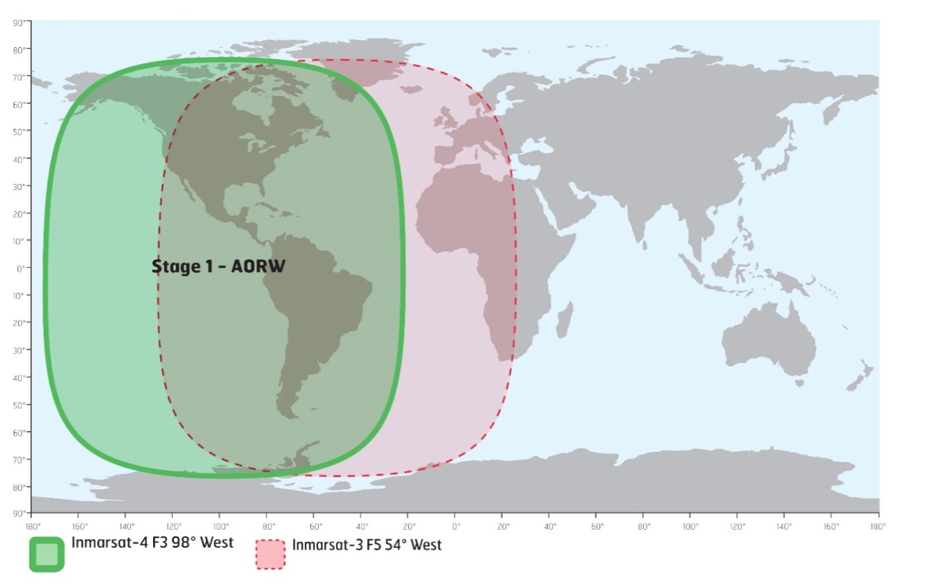
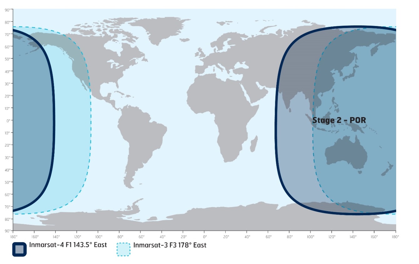
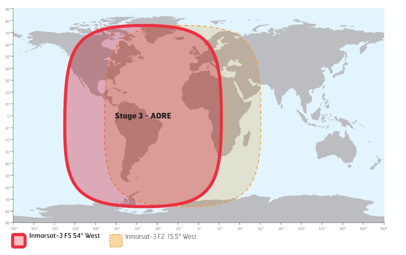
*316(T) MARINE COMMUNICATIONS AND TRAFFIC SERVICES – INMARSAT I-3 TO I-4 SATELLITE MIGRATION
The International Maritime Organization (IMO), the International Hydrographic Organization (IHO), and the World Meteorological Organization (WMO) inform the maritime community of the planned Inmarsat I-3 to I-4 satellite migration in 2018.
The services specific to the maritime sector include Inmarsat-C, Mini C, and Fleet77. These services have operated successfully over the I-4 satellites previously and therefore minimal service impact is anticipated. Inmarsat worked closely with Land Earth Station operators (LESOs), terminal manufacturers, administrations that provide Maritime Safety Information (MSI) and other stakeholders during the extensive preparation of the migration plan. Safety services will be restored first with the highest priority. The migration will have minimal impact on seafarers.
The migration will start in April 2018 and take approximately 9 months to complete. The approach of Inmarsat is to migrate these services satellite-by-satellite as illustrated below.
|
I-3 TO I-4 MIGRATION |
TIMELINES |
|---|---|
|
Atlantic Ocean Region West (AORW) I-3 to I-4 Americas (AMER) |
April 2018 |
|
Pacific Ocean Region (POR) I-3 to I-4 Asia/Pacific (APAC) |
July 2018 |
|
Atlantic Ocean Region East (AORE) I-3 moved to I-3 F5 |
September 2018 |
|
Indian Ocean Region (IOR) I-3 to I-4 Alphasat EMEA |
October 2018 |
Stage 1: AORW to AMER, April 2018
Stage 2: POR to APAC, July 2018
Stage 3: AORE to I-3 F5, September 2018
Stage 4: IOR to Alphasat EMEA, October 2018

Inmarsat will be communicating with you throughout the migration planning and execution phases, providing additional details as and when they become available. Further information can be found at https://www.inmarsat.com/i3-i4-services-migration. If you have any immediate questions or concerns, please contact Inmarsat at: maritime.safety@inmarsat.com.
*318 ALBERNI INLET – AIDS TO NAVIGATION PERMANENTLY CHANGED
Reference: Notice 619(P)/17 is cancelled (Chart 3668).
(P2017-133, 149, 150)
*319 RED DEER POINT TO/À NORTH MANITOU ISLAND – LIGHT PERMANENTLY DISCONTINUED
Reference: Notice 1008(P)/17 is cancelled (Chart 6272).
(A2018-006)
*320 PLANS, VICINITY OF/PROXIMITÉ DE BANKS ISLAND – FIELD TRIAL COMPLETED: AID TO NAVIGATION PERMANENTLY CHANGED
Reference: Notice 1011(P)/17 is cancelled (Chart 3912).
(P2017-154)
SECTION 2 - CHART CORRECTIONS
3001 - Vancouver Island / Île de Vancouver, Juan de Fuca Strait to/à Queen Charlotte Sound - New Edition - 23-FEB-2001 - NAD 1927
| 02-MAR-2018 | LNM/D. 23-FEB-2018 | ||
| Amend |
Fl to read Fl R against light (See Chart No. 1, P1) This notice affects Electronic Navigational Chart: CA370165 |
50°40′15.2″N 128°21′07.8″W | |
| (P2017101) LL(67) DFO(6203616-01) |
3080 - Stuart Lake - Sheet/Feuille 1 - New Edition - 03-APR-1992 - NAD 1983
| 23-MAR-2018 | LNM/D. 27-MAR-2015 | ||
| Add |
red starboard hand conical buoy, marked T11 (See Chart No. 1, Qf) |
54°33′34.6″N 124°36′05.2″W | |
| (P2018001) DFO(6203681-01) | |||
| Add |
yellow cautionary can buoy, marked TC (See Chart No. 1, Qm) |
54°33′44.9″N 124°36′08.1″W | |
| (P2018002) DFO(6203682-01) | |||
| Add |
light Fl (See Chart No. 1, P1) |
54°36′20.5″N 124°42′33.0″W | |
| (P2018004) LL(818.5) DFO(6203683-01) | |||
| Amend |
red starboard hand conical buoy, marked T10/2 to
read red starboard hand conical buoy, marked T6 (See Chart No. 1, Qf) |
54°38′31.0″N 124°58′48.0″W | |
| (P2018005) DFO(6203684-01) |
3313 - Approaches to/Approches à Victoria - Sheet/Feuille 4 - New Edition - 02-JAN-2009 - NAD 1983
| 02-MAR-2018 | LNM/D. 23-FEB-2018 | ||
| Delete |
anchoring prohibited area (See Chart No. 1, N20) This notice affects Electronic Navigational Chart: CA470075, CA570138 |
between 48°25′58.1″N 123°26′18.8″W and 48°26′27.9″N 123°26′11.7″W |
|
| DFO(6203638-01) | |||
| Delete |
anchoring prohibited area (See Chart No. 1, N20) This notice affects Electronic Navigational Chart: CA470075, CA570138 |
between 48°25′57.9″N 123°26′20.0″W and 48°26′13.5″N 123°26′50.0″W |
|
| DFO(6203638-02) | |||
| Add |
anchoring prohibited area (See Chart No. 1, N20) This notice affects Electronic Navigational Chart: CA470075, CA570138 |
between 48°26′53.5″N 123°27′01.8″W and 48°26′52.1″N 123°25′58.0″W |
|
| DFO(6203638-03) | |||
| Amend |
Spoil ground area to abandoned Spoil ground area (See Chart No. 1, N62.2) This notice affects Electronic Navigational Chart: CA470075 |
48°22′18.0″N 123°21′54.0″W | |
| DFO(6203641-01) |
3313 - Stuart Channel South/Sud - Sheet/Feuille 15 - New Edition - 02-JAN-2009 - NAD 1983
| 09-MAR-2018 | LNM/D. 02-MAR-2018 | ||
| Delete |
depth of 0.2 metres (See Chart No. 1, I10) This notice affects Electronic Navigational Chart: CA470070 |
49°00′30.9″N 123°35′18.2″W | |
| DFO(6203643-08) | |||
| Add |
rock awash at chart datum (See Chart No. 1, K12) This notice affects Electronic Navigational Chart: CA470070, CA570007 |
49°00′30.2″N 123°35′18.9″W | |
| DFO(6203643-09) |
3313 - Porlier Pass - Sheet/Feuille 16 - New Edition - 02-JAN-2009 - NAD 1983
| 09-MAR-2018 | LNM/D. 02-MAR-2018 | ||
| Add |
depth of 0.4 metres (See Chart No. 1, I10) This notice affects Electronic Navigational Chart: CA570007 |
49°00′44.2″N 123°36′12.8″W | |
| DFO(6203643-02) | |||
| Add |
depth of 3.8 metres (See Chart No. 1, I10) This notice affects Electronic Navigational Chart: CA570007 |
49°00′39.3″N 123°36′10.0″W | |
| DFO(6203643-03) | |||
| Delete |
depth of 1.4 metres (See Chart No. 1, I10) This notice affects Electronic Navigational Chart: CA570007 |
49°00′46.4″N 123°35′58.4″W | |
| DFO(6203643-04) | |||
| Add |
depth of 0.4 metres (See Chart No. 1, I10) This notice affects Electronic Navigational Chart: CA570007 |
49°00′46.3″N 123°35′58.4″W | |
| DFO(6203643-05) | |||
| Add |
depth of 0.8 metres (See Chart No. 1, I10) This notice affects Electronic Navigational Chart: CA570007 |
49°00′07.8″N 123°35′22.8″W | |
| DFO(6203643-06) | |||
| Add |
depth of 9.8 metres (See Chart No. 1, I10) This notice affects Electronic Navigational Chart: CA570007 |
49°00′12.8″N 123°35′25.1″W | |
| DFO(6203643-07) | |||
| Add |
rock awash at chart datum (See Chart No. 1, K12) This notice affects Electronic Navigational Chart: CA470070, CA570007 |
49°00′30.2″N 123°35′18.9″W | |
| DFO(6203643-09) | |||
| Delete |
depth of 0.9 metres (See Chart No. 1, I10) This notice affects Electronic Navigational Chart: CA570007 |
49°00′43.7″N 123°35′12.2″W | |
| DFO(6203643-10) | |||
| Add |
rock which covers and uncovers with drying height of 0.4
metres (See Chart No. 1, K11) This notice affects Electronic Navigational Chart: CA570007 |
49°00′44.0″N 123°35′12.3″W | |
| DFO(6203643-11) | |||
| Add |
depth of 0.9 metres (See Chart No. 1, I10) This notice affects Electronic Navigational Chart: CA570007 |
49°00′52.5″N 123°34′25.0″W | |
| DFO(6203643-13) | |||
| Add |
rock which covers and uncovers with drying height of 0.4
metres (See Chart No. 1, K11) This notice affects Electronic Navigational Chart: CA570007 |
49°00′52.0″N 123°34′22.2″W | |
| DFO(6203643-14) | |||
| Add |
rock awash at chart datum (See Chart No. 1, K12) This notice affects Electronic Navigational Chart: CA570007 |
49°01′10.3″N 123°35′27.1″W | |
| DFO(6203643-15) | |||
| Add |
rock which covers and uncovers with drying height of 1.4
metres (See Chart No. 1, K11) This notice affects Electronic Navigational Chart: CA570007 |
49°01′27.4″N 123°35′34.5″W | |
| DFO(6203643-17) |
3313 - Trincomali Channel - Sheet/Feuille 17 - New Edition - 02-JAN-2009 - NAD 1983
| 09-MAR-2018 | LNM/D. 02-MAR-2018 | ||
| Delete |
depth of 0.2 metres (See Chart No. 1, I10) This notice affects Electronic Navigational Chart: CA470070 |
49°00′30.9″N 123°35′18.2″W | |
| DFO(6203643-08) | |||
| Add |
rock awash at chart datum (See Chart No. 1, K12) This notice affects Electronic Navigational Chart: CA470070, CA570007 |
49°00′30.2″N 123°35′18.9″W | |
| DFO(6203643-09) |
3419 - Esquimalt Harbour - New Edition - 13-DEC-2013 - World Geodetic System 1984
| 02-MAR-2018 | LNM/D. 23-FEB-2018 | ||
| Delete |
anchoring prohibited area (See Chart No. 1, N20) This notice affects Electronic Navigational Chart: CA470075, CA570138 |
between 48°25′58.1″N 123°26′18.8″W and 48°26′27.9″N 123°26′11.7″W |
|
| DFO(6203638-01) | |||
| Delete |
anchoring prohibited area (See Chart No. 1, N20) This notice affects Electronic Navigational Chart: CA470075, CA570138 |
between 48°25′57.9″N 123°26′19.0″W and 48°26′14.0″N 123°26′48.0″W |
|
| DFO(6203638-02) | |||
| Add |
anchoring prohibited area (See Chart No. 1, N20) This notice affects Electronic Navigational Chart: CA470075, CA570138 |
between 48°26′53.9″N 123°27′00.7″W and 48°26′52.3″N 123°25′56.9″W |
|
| DFO(6203638-03) | |||
| Amend |
Anchoring and fishing prohibited area to fishing
prohibited area (See Chart No. 1, N20, N21) This notice affects Electronic Navigational Chart: CA570138 |
joining 48°26′47.7″N 123°26′54.5″W 48°26′47.2″N 123°26′54.4″W 48°26′44.0″N 123°26′42.1″W 48°26′49.3″N 123°26′39.0″W 48°26′52.5″N 123°26′51.0″W and 48°26′49.0″N 123°26′53.1″W |
|
| DFO(6203638-04) |
3440 - Race Rocks to/à D'Arcy Island - New Edition - 01-JUL-2005 - NAD 1983
| 02-MAR-2018 | LNM/D. 31-MAR-2017 | ||
| Delete |
anchoring prohibited area (See Chart No. 1, N20) This notice affects Electronic Navigational Chart: CA470075, CA570138 |
between 48°25′58.1″N 123°26′18.8″W and 48°26′27.9″N 123°26′11.7″W |
|
| DFO(6203638-01) | |||
| Delete |
anchoring prohibited area (See Chart No. 1, N20) This notice affects Electronic Navigational Chart: CA470075, CA570138 |
between 48°25′57.9″N 123°26′20.0″W and 48°26′13.5″N 123°26′50.0″W |
|
| DFO(6203638-02) | |||
| Add |
anchoring prohibited area (See Chart No. 1, N20) This notice affects Electronic Navigational Chart: CA470075, CA570138 |
between 48°26′53.5″N 123°27′01.8″W and 48°26′52.1″N 123°25′58.0″W |
|
| DFO(6203638-03) | |||
| Amend |
Spoil Ground symbol to abandoned Spoil ground
symbol (See Chart No. 1, N62.2) This notice affects Electronic Navigational Chart: CA470075 |
48°22′17.0″N 123°21′52.0″W | |
| DFO(6203641-01) | |||
| 30-MAR-2018 | LNM/D. 02-MAR-2018 | ||
| Reposition |
yellow ODAS/SADO lighted super-buoy Fl Y, marked
46088 (See Chart No. 1, Q58) |
from 48°20′01.5″N 123°09′52.6″W to 48°19′53.1″N 123°10′22.6″W |
|
| DFO(6203692-01) | |||
| Amend |
yellow ODAS/SADO lighted super-buoy Fl Y, marked 46088 to
read yellow ODAS/SADO lighted super-buoy Fl (4) Y 20s, marked 46088 (See Chart No. 1, Q58) |
48°19′53.1″N 123°10′22.6″W | |
| DFO(6203692-02) |
3442 - North Pender Island to/à Thetis Island - New Edition - 01-JUL-2005 - NAD 1983
| 09-MAR-2018 | LNM/D. 20-OCT-2017 | ||
| Delete |
depth of 0.2 metres (See Chart No. 1, I10) This notice affects Electronic Navigational Chart: CA470070 |
49°00′30.9″N 123°35′18.2″W | |
| DFO(6203643-08) | |||
| Add |
rock awash at chart datum (See Chart No. 1, K12) This notice affects Electronic Navigational Chart: CA470070, CA570007 |
49°00′30.2″N 123°35′18.9″W | |
| DFO(6203643-09) |
3443 - Thetis Island to/à Nanaimo - New Edition - 20-DEC-2002 - NAD 1983
| 09-MAR-2018 | LNM/D. 14-JUL-2017 | ||
| Delete |
depth of 0.2 metres (See Chart No. 1, I10) This notice affects Electronic Navigational Chart: CA470070 |
49°00′30.9″N 123°35′18.2″W | |
| DFO(6203643-08) | |||
| Add |
rock awash at chart datum (See Chart No. 1, K12) This notice affects Electronic Navigational Chart: CA470070, CA570007 |
49°00′30.2″N 123°35′18.9″W | |
| DFO(6203643-09) |
3461 - Juan de Fuca Strait, Eastern Portion/Partie Est - New Edition - 01-JUL-2005 - NAD 1983
| 02-MAR-2018 | LNM/D. 23-FEB-2018 | ||
| Amend |
Spoil Ground symbol to abandoned Spoil ground
symbol (See Chart No. 1, N62.2) This notice affects Electronic Navigational Chart: CA470075 |
48°22′21.5″N 123°21′46.0″W | |
| DFO(6203641-01) | |||
| 30-MAR-2018 | LNM/D. 02-MAR-2018 | ||
| Reposition |
yellow ODAS/SADO lighted super-buoy Fl Y, marked
46088 (See Chart No. 1, Q58) |
from 48°19′20.0″N 123°09′59.3″W to 48°19′53.1″N 123°10′22.6″W |
|
| DFO(6203692-01) | |||
| Amend |
yellow ODAS/SADO lighted super-buoy Fl Y, marked 46088 to
read yellow ODAS/SADO lighted super-buoy Fl(4) Y 20s, marked 46088 (See Chart No. 1, Q58) |
48°19′53.1″N 123°10′22.6″W | |
| DFO(6203692-02) |
3462 - Juan de Fuca Strait to/à Strait of Georgia - New Edition - 01-JUL-2005 - NAD 1983
| 02-MAR-2018 | LNM/D. 23-FEB-2018 | ||
| Amend |
Spoil Ground symbol to abandoned Spoil ground
symbol (See Chart No. 1, N62.2) This notice affects Electronic Navigational Chart: CA470075 |
48°22′37.0″N 123°21′54.0″W | |
| DFO(6203641-01) |
3473 - Porlier Pass - New Edition - 02-MAY-2003 - NAD 1983
| 09-MAR-2018 | LNM/D. 13-MAY-2016 | ||
| Delete |
depth of 3 metres (See Chart No. 1, I10) This notice affects Electronic Navigational Chart: CA570007 |
49°00′44.3″N 123°36′12.8″W | |
| DFO(6203643-01) | |||
| Add |
depth of 0.4 metres (See Chart No. 1, I10) This notice affects Electronic Navigational Chart: CA570007 |
49°00′44.2″N 123°36′12.8″W | |
| DFO(6203643-02) | |||
| Add |
depth of 3.8 metres (See Chart No. 1, I10) This notice affects Electronic Navigational Chart: CA570007 |
49°00′39.3″N 123°36′10.0″W | |
| DFO(6203643-03) | |||
| Delete |
depth of 1.4 metres (See Chart No. 1, I10) This notice affects Electronic Navigational Chart: CA570007 |
49°00′46.4″N 123°35′58.4″W | |
| DFO(6203643-04) | |||
| Add |
depth of 0.4 metres (See Chart No. 1, I10) This notice affects Electronic Navigational Chart: CA570007 |
49°00′46.3″N 123°35′58.4″W | |
| DFO(6203643-05) | |||
| Add |
depth of 0.8 metres (See Chart No. 1, I10) This notice affects Electronic Navigational Chart: CA570007 |
49°00′07.8″N 123°35′22.8″W | |
| DFO(6203643-06) | |||
| Add |
depth of 9.8 metres (See Chart No. 1, I10) This notice affects Electronic Navigational Chart: CA570007 |
49°00′12.8″N 123°35′25.1″W | |
| DFO(6203643-07) | |||
| Add |
rock awash at chart datum (See Chart No. 1, K12) This notice affects Electronic Navigational Chart: CA470070, CA570007 |
49°00′30.2″N 123°35′18.9″W | |
| DFO(6203643-09) | |||
| Delete |
depth of 0.9 metres (See Chart No. 1, I10) This notice affects Electronic Navigational Chart: CA570007 |
49°00′43.7″N 123°35′12.2″W | |
| DFO(6203643-10) | |||
| Add |
rock which covers and uncovers with drying height of 0.4
metres (See Chart No. 1, K11) This notice affects Electronic Navigational Chart: CA570007 |
49°00′44.0″N 123°35′12.3″W | |
| DFO(6203643-11) | |||
| Delete |
depth of 1.9 metres (See Chart No. 1, I10) This notice affects Electronic Navigational Chart: CA570007 |
49°00′52.5″N 123°34′25.4″W | |
| DFO(6203643-12) | |||
| Add |
depth of 0.9 metres (See Chart No. 1, I10) This notice affects Electronic Navigational Chart: CA570007 |
49°00′52.5″N 123°34′25.0″W | |
| DFO(6203643-13) | |||
| Add |
rock which covers and uncovers with drying height of 0.4
metres (See Chart No. 1, K11) This notice affects Electronic Navigational Chart: CA570007 |
49°00′52.0″N 123°34′22.2″W | |
| DFO(6203643-14) | |||
| Add |
rock awash at chart datum (See Chart No. 1, K12) This notice affects Electronic Navigational Chart: CA570007 |
49°01′10.3″N 123°35′27.1″W | |
| DFO(6203643-15) | |||
| Delete |
depth of 0.6 metres (See Chart No. 1, I10) This notice affects Electronic Navigational Chart: CA570007 |
49°01′27.2″N 123°35′33.7″W | |
| DFO(6203643-16) | |||
| Add |
rock which covers and uncovers with drying height of 1.4
metres (See Chart No. 1, K11) This notice affects Electronic Navigational Chart: CA570007 |
49°01′27.4″N 123°35′34.5″W | |
| DFO(6203643-17) |
3493 - Vancouver Harbour Western Portion/Partie Ouest - New Edition - 11-JUN-2010 - NAD 1983
| 30-MAR-2018 | LNM/D. 08-DEC-2017 | ||
| Amend |
orange spherical control buoy to read orange spherical
control buoy, marked Priv (See Chart No. 1, Qo, Q22) This notice affects Electronic Navigational Chart: CA570073 |
49°17′30.2″N 123°06′55.7″W | |
| DFO(6203693-01) |
3527 - Baynes Sound - New Edition - 06-APR-2001 - NAD 1983
| 30-MAR-2018 | LNM/D. 23-FEB-2018 | ||
| Delete |
green port hand spar buoy, marked P37 (See Chart No. 1, Qg) This notice affects Electronic Navigational Chart: CA470218 |
49°29′49.3″N 124°40′47.7″W | |
| DFO(6203694-01) | |||
| Add |
green port hand pillar buoy, marked P37 (See Chart No. 1, Qg) This notice affects Electronic Navigational Chart: CA470218 |
49°29′48.9″N 124°40′44.9″W | |
| DFO(6203694-02) |
3536 - Sturt Bay and/et Vananda Cove - New Chart - 21-APR-1978 - NAD 1927
| 23-MAR-2018 | LNM/D. 01-DEC-2017 | ||
| Delete |
pier (See Chart No. 1, F14) This notice affects Electronic Navigational Chart: CA570158 |
joining 49°45′36.1″N 124°33′52.2″W 49°45′36.3″N 124°33′51.9″W 49°45′36.0″N 124°33′51.4″W 49°45′36.0″N 124°33′51.3″W 49°45′36.6″N 124°33′51.9″W 49°45′37.0″N 124°33′51.6″W 49°45′37.0″N 124°33′51.7″W 49°45′36.6″N 124°33′52.2″W 49°45′37.2″N 124°33′52.9″W 49°45′37.1″N 124°33′52.9″W 49°45′36.9″N 124°33′52.7″W and 49°45′36.6″N 124°33′52.9″W |
|
| DFO(6203690-01) | |||
| Add |
wharf in ruins with legend Ru (See Chart No. 1, F33) This notice affects Electronic Navigational Chart: CA570158 |
joining 49°45′36.3″N 124°33′52.5″W 49°45′36.6″N 124°33′52.0″W 49°45′37.0″N 124°33′52.5″W and 49°45′36.8″N 124°33′52.9″W |
|
| DFO(6203690-02) |
3605 - Quatsino Sound to/à Queen Charlotte Strait - New Edition - 06-MAR-1998 - NAD 1983
| 02-MAR-2018 | LNM/D. 24-NOV-2017 | ||
| Amend |
Fl to read Fl R against light (See Chart No. 1, P1) This notice affects Electronic Navigational Chart: CA370165 |
50°40′15.2″N 128°21′07.8″W | |
| (P2017101) LL(67) DFO(6203616-01) |
3606 - Juan de Fuca Strait - New Edition - 29-NOV-2002 - NAD 1983
| 02-MAR-2018 | LNM/D. 23-FEB-2018 | ||
| Amend |
Spoil Ground symbol to abandoned Spoil ground
symbol (See Chart No. 1, N62.2) This notice affects Electronic Navigational Chart: CA470075 |
48°22′17.0″N 123°22′01.0″W | |
| DFO(6203641-01) |
3624 - Cape Cook to Cape Scott - New Edition - 19-AUG-1988 - NAD 1927
| 02-MAR-2018 | LNM/D. 16-JAN-2015 | ||
| Amend |
Fl to read Fl R against light (See Chart No. 1, P1) This notice affects Electronic Navigational Chart: CA370165 |
50°40′15.9″N 128°21′01.9″W | |
| (P2017101) LL(67) DFO(6203616-01) |
3624 - Sea Otter Cove - New Edition - 19-AUG-1988 - NAD 1927
| 02-MAR-2018 | LNM/D. 16-JAN-2015 | ||
| Amend |
Fl to read Fl R against light (See Chart No. 1, P1) This notice affects Electronic Navigational Chart: CA370165 |
50°40′15.9″N 128°21′01.9″W | |
| (P2017101) LL(67) DFO(6203616-01) |
3646 - Uchucklesit Inlet - New Edition - 30-JUN-1995 - NAD 1983
| 09-MAR-2018 | LNM/D. 12-OCT-2012 | ||
| Amend |
Q to read Fl(2) G 5s against light (See Chart No. 1, P1) This notice affects Electronic Navigational Chart: CA470167, CA570228 |
48°58′56.0″N 124°58′22.6″W | |
| (P2017136) LL(154.8) DFO(6203660-02) |
3668 - Alberni Inlet - New Edition - 07-APR-2000 - NAD 1983
| 09-MAR-2018 | LNM/D. 10-NOV-2017 | ||
| Amend |
Fl with radar reflector to read Q R without radar
reflector against light (See Chart No. 1, P1) This notice affects Electronic Navigational Chart: CA470167 |
48°58′37.4″N 124°56′49.8″W | |
| (P2017133 & P2018018) LL(155) DFO(6203657-01) | |||
| Delete |
radar reflector (See Chart No. 1, S4) This notice affects Electronic Navigational Chart: CA470167 |
48°58′56.0″N 124°58′22.6″W | |
| (P2017136) LL(154.8) DFO(6203660-01) | |||
| Amend |
Q to read Fl(2) G 5s against light (See Chart No. 1, P1) This notice affects Electronic Navigational Chart: CA470167, CA570228 |
48°58′56.0″N 124°58′22.6″W | |
| (P2017136) LL(154.8) DFO(6203660-02) | |||
| Delete |
radar reflector (See Chart No. 1, S4) This notice affects Electronic Navigational Chart: CA470167, CA570170 |
48°57′55.9″N 125°04′54.8″W | |
| (P2017137) LL(152) DFO(6203661-01) | |||
| Delete |
radar reflector (See Chart No. 1, S4) This notice affects Electronic Navigational Chart: CA470167 |
48°56′58.7″N 125°09′18.2″W | |
| LL(151) DFO(6203662-01) | |||
| Amend |
Fl to read Fl R against light (See Chart No. 1, P1) This notice affects Electronic Navigational Chart: CA470167 |
48°54′05.2″N 125°03′28.2″W | |
| (P2017141) LL(170) DFO(6203665-01) | |||
| 23-MAR-2018 | LNM/D. 09-MAR-2018 | ||
| Delete |
radar reflector (See Chart No. 1, S4) This notice affects Electronic Navigational Chart: CA470167, CA570168 |
49°13′39.8″N 124°49′32.6″W | |
| (P2017142) LL(166) DFO(6203666-01) | |||
| Delete |
radar reflector (See Chart No. 1, S4) This notice affects Electronic Navigational Chart: CA470167 |
49°11′02.9″N 124°48′59.1″W | |
| (P2017143) LL(164) DFO(6203667-01) | |||
| Delete |
radar reflector (See Chart No. 1, S4) This notice affects Electronic Navigational Chart: CA470167, CA570168 |
49°12′57.6″N 124°49′01.4″W | |
| (P2017148) LL(165) DFO(6203672-01) | |||
| Amend |
Fl with radar reflector to read FlG with no radar
reflector against light (See Chart No. 1, P1, S4) This notice affects Electronic Navigational Chart: CA470167 |
49°09′14.6″N 124°48′29.9″W | |
| (P2017149) LL(162) DFO(6203673-01) | |||
| Amend |
Fl with radar reflector to read FlG with no radar
reflector against light (See Chart No. 1, P1, S4) This notice affects Electronic Navigational Chart: CA470167 |
49°00′44.6″N 124°52′20.4″W | |
| (P2017150) LL(157) DFO(6203674-01) | |||
| Delete |
radar reflector (See Chart No. 1, S4) This notice affects Electronic Navigational Chart: CA470167 |
49°03′33.1″N 124°50′27.0″W | |
| (P2017151) LL(158) DFO(6203675-01) | |||
| Delete |
radar reflector (See Chart No. 1, S4) This notice affects Electronic Navigational Chart: CA470167 |
49°05′16.5″N 124°49′53.0″W | |
| (P2017152) LL(159) DFO(6203676-01) |
3668 - Entrance to/Entrée à Useless Inlet - New Edition - 07-APR-2000 - NAD 1983
| 09-MAR-2018 | LNM/D. 10-NOV-2017 | ||
| Delete |
radar reflector (See Chart No. 1, S4) This notice affects Electronic Navigational Chart: CA470167, CA570170 |
48°57′55.9″N 125°04′54.8″W | |
| (P2017137) LL(152) DFO(6203661-01) |
3668 - Port Alberni - New Edition - 07-APR-2000 - NAD 1983
| 23-MAR-2018 | LNM/D. 09-MAR-2018 | ||
| Delete |
radar reflector (See Chart No. 1, S4) This notice affects Electronic Navigational Chart: CA470167, CA570168 |
49°13′39.8″N 124°49′32.6″W | |
| (P2017142) LL(166) DFO(6203666-01) | |||
| Delete |
radar reflector (See Chart No. 1, S4) This notice affects Electronic Navigational Chart: CA470167, CA570168 |
49°12′57.6″N 124°49′01.4″W | |
| (P2017148) LL(165) DFO(6203672-01) |
3670 - Broken Group - New Edition - 21-OCT-1994 - NAD 1983
| 09-MAR-2018 | LNM/D. 09-DEC-2016 | ||
| Amend |
Fl(3) to read Fl(3) 12s against light (See Chart No. 1, P1) This notice affects Electronic Navigational Chart: CA470338, CA570336 |
48°55′32.6″N 125°13′19.6″W | |
| (P2017139) LL(150) DFO(6203663-01) | |||
| Add |
radar reflector (See Chart No. 1, S4) This notice affects Electronic Navigational Chart: CA470338, CA570336 |
48°55′32.6″N 125°13′19.6″W | |
| LL(150) DFO(6203663-02) |
3671 - Barkley Sound - New Edition - 04-NOV-2005 - NAD 1983
| 09-MAR-2018 | LNM/D. 31-MAR-2017 | ||
| Delete |
radar reflector (See Chart No. 1, S4) This notice affects Electronic Navigational Chart: CA470167, CA570170 |
48°57′55.9″N 125°04′54.8″W | |
| (P2017137) LL(152) DFO(6203661-01) | |||
| Amend |
Fl R 4s11m4M to read Fl R 13m4M against light (See Chart No. 1, P1) |
48°57′55.9″N 125°04′54.8″W | |
| (P2017137) LL(152) DFO(6203661-02) | |||
| Amend |
Fl 4s12m5M to read Fl 10m5M against light (See Chart No. 1, P1) This notice affects Electronic Navigational Chart: CA470167 |
48°56′58.7″N 125°09′18.2″W | |
| (P2017138) LL(151) DFO(6203662-02) | |||
| Amend |
Fl(3) 12s9m5M to read Fl(3) 12s11m5M against light (See Chart No. 1, P1) This notice affects Electronic Navigational Chart: CA470338, CA570336 |
48°55′32.6″N 125°13′19.6″W | |
| (P2017139) LL(150) DFO(6203663-01) | |||
| Add |
radar reflector (See Chart No. 1, S4) This notice affects Electronic Navigational Chart: CA470338, CA570336 |
48°55′32.6″N 125°13′19.6″W | |
| LL(150) DFO(6203663-02) | |||
| Amend |
Fl (2) to read Fl(2) 6s against light (See Chart No. 1, P1) This notice affects Electronic Navigational Chart: CA470338 |
48°51′28.8″N 125°09′36.8″W | |
| (P2017140) LL(171) DFO(6203664-01) | |||
| Amend |
Fl to read Fl R against light (See Chart No. 1, P1) This notice affects Electronic Navigational Chart: CA470167 |
48°54′05.2″N 125°03′28.2″W | |
| (P2017141) LL(170) DFO(6203665-01) |
3675 - Nootka Sound - New Chart - 20-NOV-1998 - NAD 1983
| 09-MAR-2018 | LNM/D. 02-MAR-2018 | ||
| Amend |
Q R to read Fl(3) R 12s against light (See Chart No. 1, P1) This notice affects Electronic Navigational Chart: CA470352 |
49°38′46.0″N 126°28′17.5″W | |
| (P2017124) LL(109.8) DFO(6203648-01) |
3675 - Continuation A - New Chart - 20-NOV-1998 - NAD 1983
| 02-MAR-2018 | LNM/D. 15-JUL-2016 | ||
| Amend |
Fl to read Fl R against light (See Chart No. 1, P1) This notice affects Electronic Navigational Chart: CA470279 |
49°39′47.3″N 126°09′31.8″W | |
| (P2017113) LL(112.4) DFO(6203633-01) |
3726 - Laredo Sound and Approaches - New Edition - 07-OCT-2016 - World Geodetic System 1984
| 16-MAR-2018 | |||
| Add |
rock which covers and uncovers with drying height of 4
feet (See Chart No. 1, K11) This notice affects Electronic Navigational Chart: CA570437 |
52°30′30.3″N 129°02′48.7″W | |
| DFO(6203679-01) | |||
| 30-MAR-2018 | LNM/D. 16-MAR-2018 | ||
| Add |
note Chart/Carte 3980 (See Chart No. 1, A18) |
52°16′54.0″N 128°50′00.0″W | |
| DFO(6203703-13) | |||
| Add |
note Chart/Carte 3980 (See Chart No. 1, A18) |
52°32′16.0″N 128°53′09.0″W | |
| DFO(6203703-16) |
3728 - Milbanke Sound and Approaches/et les approches - New Edition - 05-FEB-1982 - NAD 1927
| 30-MAR-2018 | LNM/D. 12-AUG-2011 | ||
| Add |
note Chart/Carte 3980 (See Chart No. 1, A18) |
52°13′42.0″N 128°48′20.0″W | |
| DFO(6203703-12) |
3733 - Catala Passage - New Chart - 30-AUG-2002 - NAD 1983
| 30-MAR-2018 | LNM/D. 25-JUN-2004 | ||
| Amend |
note Adjoining Chart/Carte adjacente 3728 to read Adjoining Chart/Carte adjacente 3980 (See Chart No. 1, A20) |
outside west border at 52-16-15 | |
| DFO(6203703-04) | |||
| Amend |
note Adjoining Chart/Carte adjacente 3728 to read Adjoining Chart/Carte adjacente 3980 (See Chart No. 1, A20) |
outside north border at 128-43-30 | |
| DFO(6203703-05) | |||
| Amend |
note Adjoining Chart/Carte adjacente 3728 to read Adjoining Chart/Carte adjacente 3941 (See Chart No. 1, A20) |
outside east border at 52-15-45 | |
| DFO(6203703-06) |
3737 - Laredo Channel including/y compris Laredo Inlet and/et Surf Inlet - New Edition - 14-AUG-1987 - Unknown
| 16-MAR-2018 | LNM/D. 02-FEB-2018 | ||
| Add |
rock which covers and uncovers with drying height of 4
feet (See Chart No. 1, K11) This notice affects Electronic Navigational Chart: CA570437 |
52°30′32.1″N 129°02′44.5″W | |
| DFO(6203679-01) |
3742 - Otter Passage to/à McKay Reach - New Edition - 16-JUL-1982 - NAD 1927
| 30-MAR-2018 | LNM/D. 05-JAN-2018 | ||
| Add |
obstruction with known depth of 21 fathoms (See Chart No. 1, K41) This notice affects Electronic Navigational Chart: CA370721 |
53°29′03.1″N 129°10′32.1″W | |
| DFO(6203691-02) | |||
| Add |
obstruction with known depth of 77 fathoms (See Chart No. 1, K41) This notice affects Electronic Navigational Chart: CA370721 |
53°29′11.4″N 129°10′53.8″W | |
| DFO(6203691-03) |
3744 - Queen Charlotte Sound - New Edition - 20-MAY-1988 - NAD 1927
| 02-MAR-2018 | LNM/D. 02-FEB-2018 | ||
| Add |
light Fl R (See Chart No. 1, P1) This notice affects Electronic Navigational Chart: CA270084 |
50°40′15.9″N 128°21′01.8″W | |
| (P2017101) LL(67) DFO(6203616-02) | |||
| 30-MAR-2018 | LNM/D. 02-MAR-2018 | ||
| Add |
note Chart/Carte 3980 (See Chart No. 1, A18) |
52°14′00.0″N 128°50′00.0″W | |
| DFO(6203703-15) |
3808 - Juan Perez Sound - New Edition - 30-DEC-2005 - NAD 1983
| 09-MAR-2018 | LNM/D. 22-DEC-2017 | ||
| Add |
depth of 0.8 metres (See Chart No. 1, I10) This notice affects Electronic Navigational Chart: CA470330 |
52°32′02.7″N 131°40′17.4″W | |
| DFO(6203646-01) | |||
| Delete |
out of position depth of 5.5 metres (See Chart No. 1, I11) This notice affects Electronic Navigational Chart: CA470330 |
52°32′15.7″N 131°40′14.7″W | |
| DFO(6203646-02) | |||
| Add |
out of position depth of 1.2 metres (See Chart No. 1, I11) This notice affects Electronic Navigational Chart: CA470330 |
52°32′16.1″N 131°40′14.4″W | |
| DFO(6203646-03) | |||
| Add |
depth of 1 metre (See Chart No. 1, I10) This notice affects Electronic Navigational Chart: CA470330 |
52°32′52.2″N 131°40′55.3″W | |
| DFO(6203646-04) | |||
| Delete |
depth of 3.7 metres (See Chart No. 1, I10) This notice affects Electronic Navigational Chart: CA470330 |
52°32′56.7″N 131°41′06.3″W | |
| DFO(6203646-05) | |||
| Add |
depth of 1.5 metres (See Chart No. 1, I10) This notice affects Electronic Navigational Chart: CA470330 |
52°32′56.5″N 131°41′06.4″W | |
| DFO(6203646-06) | |||
| Delete |
depth of 4.3 metres (See Chart No. 1, I10) This notice affects Electronic Navigational Chart: CA470330 |
52°32′59.3″N 131°41′02.5″W | |
| DFO(6203646-07) | |||
| Add |
depth of 1.4 metres (See Chart No. 1, I10) This notice affects Electronic Navigational Chart: CA470330 |
52°33′00.7″N 131°41′02.6″W | |
| DFO(6203646-08) |
3902 - Hecate Strait - New Edition - 09-DEC-1988 - NAD 1927
| 30-MAR-2018 | LNM/D. 02-FEB-2018 | ||
| Add |
note Chart/Carte 3980 (See Chart No. 1, A18) |
52°17′30.0″N 128°54′00.0″W | |
| DFO(6203703-14) |
3910 - Borrowman Bay - New Chart - 01-APR-2011 - NAD 1983
| 16-MAR-2018 | LNM/D. 05-AUG-2011 | ||
| Delete |
depth of 2.3 metres (See Chart No. 1, I10) This notice affects Electronic Navigational Chart: CA570436 |
52°45′16.5″N 129°18′03.1″W | |
| DFO(6203679-02) | |||
| Add |
rock awash at chart datum (See Chart No. 1, K12) This notice affects Electronic Navigational Chart: CA570436 |
52°45′16.9″N 129°18′02.0″W | |
| DFO(6203679-03) |
3910 - Higgins Passage - New Chart - 01-APR-2011 - NAD 1983
| 30-MAR-2018 | LNM/D. 16-MAR-2018 | ||
| Amend |
note Adjoining Chart/Carte adjacente 3737 to read Adjoining Chart/Carte adjacente 3980 (See Chart No. 1, A20) |
outside west border at 52-28-45 | |
| DFO(6203703-10) |
3910 - Weeteeam Bay - New Chart - 01-APR-2011 - NAD 1983
| 16-MAR-2018 | LNM/D. 05-AUG-2011 | ||
| Add |
rock which covers and uncovers with drying height of 1.2
metres (See Chart No. 1, K11) This notice affects Electronic Navigational Chart: CA570437 |
52°30′30.3″N 129°02′48.7″W | |
| DFO(6203679-01) |
3912 - Port Canaveral - New Edition - 14-AUG-2015 - World Geodetic System 1984
| 23-MAR-2018 | LNM/D. 27-MAY-2016 | ||
| Amend |
Fl to read Q R against light (See Chart No. 1, P1) This notice affects Electronic Navigational Chart: CA470618 |
53°32′58.5″N 130°08′40.8″W | |
| (P2017154) LL(738) DFO(6203678-01) |
3941 - Channels/Chenaux Vicinity of/Proximité de Milbanke Sound - New Edition - 01-AUG-2014 - NAD 1983
| 30-MAR-2018 | LNM/D. 15-SEP-2017 | ||
| Amend |
note Adjoining Chart/Carte adjacente 3728 to read Adjoining Chart/Carte adjacente 3980 (See Chart No. 1, A20) |
outside west border at 52-16-30 | |
| DFO(6203703-01) | |||
| Amend |
note Adjoining Chart/Carte adjacente 3737 to read Adjoining Chart/Carte adjacente 3980 (See Chart No. 1, A20) |
outside west border at 52-28-18 | |
| DFO(6203703-02) |
3941 - Jackson Narrows - New Edition - 01-AUG-2014 - NAD 1983
| 30-MAR-2018 | LNM/D. 15-SEP-2017 | ||
| Add |
sounding of 3.3 metres, Rep (2018) (See Chart No. 1, I10) This notice affects Electronic Navigational Chart: CA570580 |
52°31′26.3″N 128°18′02.7″W | |
| DFO(6203702-01) |
3943 - Finlayson Channel and/et Tolmie Channel - New Chart - 25-APR-2008 - NAD 1983
| 30-MAR-2018 | LNM/D. 04-NOV-2016 | ||
| Amend |
note Adjoining Chart/Carte adjacente 3737 to read Adjoining Chart/Carte adjacente 3980 (See Chart No. 1, A20) |
outside south border at 128-46-18 | |
| DFO(6203703-07) | |||
| Amend |
note Adjoining Chart/Carte adjacente 3737 to read Adjoining Chart/Carte adjacente 3981 (See Chart No. 1, A20) |
52°41′09.0″N 128°45′30.0″W | |
| DFO(6203703-08) | |||
| Amend |
note Adjoining Chart/Carte adjacente 3981 to read Adjoining Chart/Carte adjacente 3980 (See Chart No. 1, A20) |
outside west border at 52-37-30 | |
| DFO(6203703-09) |
3977 - Douglas Channel - New Chart - 27-DEC-2013 - World Geodetic System 1984
| 30-MAR-2018 | LNM/D. 09-FEB-2018 | ||
| Delete |
depth of 36 metres (See Chart No. 1, I10) This notice affects Electronic Navigational Chart: CA370721 |
53°28′59.0″N 129°10′33.0″W | |
| DFO(6203691-01) | |||
| Add |
obstruction with known depth of 38 metres (See Chart No. 1, K41) This notice affects Electronic Navigational Chart: CA370721 |
53°29′02.3″N 129°10′38.2″W | |
| DFO(6203691-02) | |||
| Add |
obstruction with known depth of 140 metres (See Chart No. 1, K41) This notice affects Electronic Navigational Chart: CA370721 |
53°29′10.6″N 129°10′59.9″W | |
| DFO(6203691-03) |
3978 - Bonilla Island to/à Edye Passage - New Chart - 01-JUL-2016 - World Geodetic System 1984
| 30-MAR-2018 | LNM/D. 16-FEB-2018 | ||
| Add |
radar reflector against light Q (See Chart No. 1, S4) |
53°47′20.8″N 130°20′50.3″W | |
| LL(745.1) DFO(6203704-01) |
3981 - Laredo Channel and/et Laredo Inlet - New Chart - 19-APR-2013 - NAD 1983
| 30-MAR-2018 | LNM/D. 27-MAY-2016 | ||
| Amend |
note Adjoining Chart/Carte adjacente 3737 to read Adjoining Chart/Carte adjacente 3980 (See Chart No. 1, A20) |
outside south border at 128-50-00 | |
| DFO(6203703-03) |
3985 - Principe Channel Central Portion/Partie Centrale and/et Petrel Channel - New Chart - 25-DEC-2009 - NAD 1983
| 23-MAR-2018 | LNM/D. 09-FEB-2018 | ||
| Amend |
Fl 9m7M to read Q R 6m5M against light (See Chart No. 1, P1) This notice affects Electronic Navigational Chart: CA470618 |
53°32′58.5″N 130°08′40.8″W | |
| (P2017154) LL(738) DFO(6203678-01) | |||
| 30-MAR-2018 | LNM/D. 23-MAR-2018 | ||
| Add |
radar reflector against light Q 7m2M (See Chart No. 1, S4) |
53°47′20.8″N 130°20′50.3″W | |
| LL(745.1) DFO(6203704-01) |
3986 - Browning Entrance - New Chart - 25-DEC-2009 - NAD 1983
| 30-MAR-2018 | LNM/D. 16-FEB-2018 | ||
| Add |
radar reflector against light Q 7m2M (See Chart No. 1, S4) |
53°47′20.8″N 130°20′50.3″W | |
| LL(745.1) DFO(6203704-01) |
3987 - Kitkatla Channel and/et Porcher Inlet - New Chart - 25-DEC-2009 - NAD 1983
| 30-MAR-2018 | LNM/D. 16-FEB-2018 | ||
| Add |
radar reflector against light Q 7m2M (See Chart No. 1, S4) |
53°47′20.8″N 130°20′50.3″W | |
| LL(745.1) DFO(6203704-01) |
3994 - Portland Inlet, Khutzeymateen Inlet and Pearse Canal - New Edition - 20-JAN-1989 - NAD 1927
| 30-MAR-2018 | LNM/D. 22-SEP-1995 | ||
| Amend |
Fl to read Fl 6s against light (See Chart No. 1, P1) |
54°50′01.5″N 130°16′28.3″W | |
| LL(754) DFO(6203701-01) |
6270 - Lake Winnipegosis/Lac Winnipegosis - Sheet/Feuille 1 - New Edition - 27-MAY-2005 - Unknown
| 16-MAR-2018 | LNM/D. 14-FEB-2014 | ||
| Delete |
light, Fl (See Chart No. 1, P1) |
52°25′19.9″N 100°01′27.5″W | |
| (A2018006) LL(1638.1) DFO(6604386-01) |
6272 - Red Deer Point to/à North Manitou Island - Sheet/Feuille 1 - New Edition - 27-MAY-2005 - Unknown
| 16-MAR-2018 | LNM/D. 24-MAR-2017 | ||
| Delete |
light, Fl (See Chart No. 1, P1) |
52°25′19.4″N 100°01′30.0″W | |
| (A2018006) LL(1638.1) DFO(6604386-01) |
6425 - Travaillant River to/à Adam Cabin Creek Kilometre 1325 / Kilomètre 1400 - New Edition - 15-JAN-2016 - World Geodetic System 1984
| 23-MAR-2018 | LNM/D. 14-JUL-2017 | ||
| Reposition |
red starboard hand conical buoy (See Chart No. 1, Qf) |
from 67°16′38.1″N 132°33′31.6″W to 67°16′30.0″N 132°34′40.0″W |
|
| DFO(6604390-01) | |||
| Reposition |
port hand daybeacon, marked RAM (See Chart No. 1, Qt) |
from 67°17′17.5″N 132°33′13.9″W to 67°17′07.0″N 132°34′09.0″W |
|
| DFO(6604390-02) |
7083 - Cambridge Bay to/à Shepherd Bay - New Edition - 25-MAR-2016 - Unknown
| 16-MAR-2018 | LNM/D. 27-OCT-2017 | ||
| Delete |
red beacon, ″Bn R″ and radar reflector (See Chart No. 1, Q81, S4) This notice affects Electronic Navigational Chart: CA373267 |
67°57′13.5″N 102°40′53.0″W | |
| (A2018007) DFO(6604387-01) |
7783 - Queen Maud Gulf Eastern Portion/Partie est - New Edition - 13-JUN-1997 - NAD 1983
| 16-MAR-2018 | LNM/D. 02-DEC-2011 | ||
| Delete |
red beacon, ″Bn R″ and radar reflector, ″Ra
Conspic″ (See Chart No. 1, Q81, S4) This notice affects Electronic Navigational Chart: CA373267 |
67°57′18.0″N 102°40′00.0″W | |
| (A2018007) DFO(6604387-01) |
SECTION 3 - RADIO AIDS TO MARINE NAVIGATION CORRECTIONS
NO CORRECTIONS FOR THIS SECTION.
SECTION 4 - SAILING DIRECTIONS AND SMALL CRAFT GUIDE CORRECTIONS
NO CORRECTIONS FOR THIS SECTION.
SECTION 5 - LIST OF LIGHTS, BUOYS AND FOG SIGNALS CORRECTIONS
The amendments are highlighted and deletions are crossed out. For general and region-specific
information on the List of Lights, click on the links below:
Newfoundland and Labrador Coast,
Atlantic Coast,
Inland Waters and
Pacific Coast.
PACIFIC COAST
| No. | Name | Position ----- Latitude N. Longitude W. |
Light Characteristics |
Focal Height in m. above water |
Nominal Range |
Description ----- Height in meters above ground |
Remarks ----- Fog Signals |
|||
|---|---|---|---|---|---|---|---|---|---|---|
WEST COAST, VANCOUVER ISLAND (LL 66 – 179.1) | ||||||||||
|
66 G5172 |
Cape Scott |
On NW. tip of Vancouver Island. 50 46 56.5 128 25 39.0 |
Fl | W | 10s | 69.9 | 19 |
Square skeleton tower, red top.
9.0 |
Flash 0.2 s; eclipse. 9.8 s. Visible from 344° through N., E. and S. to 246°. Operates 24 h. Year round. Chart:3625 Edn 03/18 (P18-045) |
|
|
67 G5174 |
Sea Otter Cove |
E. side of cove. 50 40 15.9 128 21 01.9 |
Fl | R | 4s | 6.5 | 5 | White square tower, red band at top. |
Year round. Chart:3624 Edn 03/18 (P17-101) |
|
|
81 G5200 |
Gayward Rock |
W. entrance to Nicolaye Channel. 50 01 15.3 127 23 27.5 |
Q | W | 1s | 8.4 | 6 | White square tower. |
Radar reflector. Year round. Chart:3677 Edn 03/18 (P18-031) |
|
|
81.5 G5201 |
Rolston Island |
Nicolaye Channel, Kyuquot Sound. 50 01 16.5 127 21 57.9 |
Fl | R | 4s | 6.3 | 3 | White square tower, red band at top. |
Year round. Chart:3677 Edn 03/18 (P18-032) |
|
|
82 G5202 |
Amos Island | Nicolaye Channel, Kyuquot Sound. 50 00 45.8 127 21 10.4 |
Fl | W | 4s | 7.5 | 3 | White square tower. |
Year round. Chart:3677 Edn 03/18 (P18-033) |
|
|
85 G5203 |
Karouk Island | At entrance to Fair Harbour, Tahsish Inlet. 50 04 36.9 127 09 40.2 |
Fl | W | 4s | 7.5 | 5 | White cylindrical tower. |
Year round. Chart:3677 Edn 03/18 (P18-034) |
|
|
87 G5203.4 |
Fair Harbour | On E. shore at the harbour entrance. 50 04 07.3 127 08 38.0 |
Fl | W | 4s | 10.5 | 5 | White cylindrical tower. |
Year round. Chart:3677 Edn 03/18 (P18-040) |
|
|
92 G5206.4 |
Centre Island | NW. shore of island. 49 50 56.7 126 56 08.0 |
Fl | R | 4s | 7.8 | 5 | White cylindrical tower, red band at top. |
Radar reflector. Year round. Chart:3676 Edn 03/18 (P18-035) |
|
|
93 G5206.6 |
Ehatisaht |
On point, E. of Ehatisaht. 49 52 51.1 126 49 31.5 |
Fl | W | 4s | 10.6 | 5 |
White square tower.
|
Year round. Chart:3676 Edn 03/18 (P18-017) |
|
|
97.8 G5209.5 |
McBride Bay |
49 51 39.4 126 43 47.3 |
Q | R | 1s | 6.8 | 5 |
White square tower, red band at top.
4.6 |
Radar reflector. Year round. Chart:3676 Edn 03/18 (P18-012) |
|
|
98.3 G5210.4 |
Tahsis Narrows South | South side of narrows. 49 51 36.0 126 41 30.4 |
Fl(2) | W | 6s | 7.2 | 5 | White square tower |
Flash 0.5 s; eclipse 1 s; flash 0.5 s; eclipse 4 s. Radar reflector. Year round. Chart:3676 Edn 03/18 (P18-011) |
|
|
104 G5217 |
Boston Point | On point. 49 39 41.1 126 36 45.9 |
Fl | G | 4s | 9.4 | 4 | White square tower, green band at top. |
Year round. Chart:3675 Edn 03/18 (P18-038) |
|
|
108.5 G5219.6 |
Zuciarte Channel South | S. entrance to channel. 49 35 43.0 126 31 18.4 |
Fl | R | 4s | 9.0 | 4 | White cylindrical tower, red band at top. |
Radar reflector. Year round. Chart:3675 Edn 03/18 (P18-036) |
|
|
109.8 G5220.1 |
Anderson Point |
49 38 46.0 126 28 17.5 |
Fl(3) | R | 12s | 7.4 | 4 | White cylindrical tower, red band at top. | Flash 1 s; eclipse 2 s; flash 1 s; eclipse 2 s; flash 1 s; eclipse 5 s. Radar reflector. Year round. Chart:3675 Edn 03/18 (P17-124) |
|
|
112.4 G5221.6 |
Victor Island |
North side of island. 49 39 47.3 126 09 32.1 |
Fl | R | 4s | 7.9 | 5 | White square tower, red band at top. |
Year round. Chart:3675 Edn 03/18 (P17-113) |
|
|
150 G5254 |
Swale Rock |
48 55 32.6 125 13 19.6 |
Fl(3) | W | 12s | 10.5 | 5 | White square tower. | Flash 0.5 s; eclipse 2 s; flash 0.5 s; eclipse 2 s; flash 0.5 s; eclipse 6.5 s. Radar reflector. Year round. Chart:3670 Edn 03/18 (P17-139) |
|
|
151 G5254.5 |
Baeria Rocks |
48 56 58.7 125 09 18.2 |
Fl | W | 4s | 10.4 | 5 |
|
Year round. Chart:3671 Edn 03/18 (P17-138) |
|
|
152 G5255 |
Pill Point |
48 57 55.9 125 04 54.8 |
Fl | R | 4s | 13.3 | 4 | White square tower, red band at top. |
Year round. Chart:3668 Edn 03/18 (P17-137) |
|
|
154.8 G5262.6 |
Limestone Islet |
On islet. 48 58 56.0 124 58 22.6 |
Fl(2) | G | 5s | 8.1 | 6 | White square tower, green band at top. |
Year round. Chart:3646 Edn 03/18 (P17-136) |
|
|
155 G5263 |
Star Point |
On point, S. shore. 48 58 37.4 124 56 49.8 |
Q | R | 1s | 6.9 | 5 | White square tower, red band at top. |
Year round. Chart:3668 Edn 03/18 (P17-133, P18-018) |
|
|
157 G5265 |
Bilton Point |
On point. 49 00 44.6 124 52 20.4 |
Fl | G | 4s | 8.6 | 5 | White square tower, green band at top. |
Year round. Chart:3668 Edn 03/18 (P17-150) |
|
|
158 G5266 |
Ten Mile Point |
On point opposite Nahmint Bay. 49 03 33.1 124 50 27.0 |
Fl | R | 4s | 8.9 | 5 | White square tower, red band at top. |
Year round. Chart:3668 Edn 03/18 (P17-151) |
|
|
159 G5267 |
Hocking Point |
On extremity of point, W. side of Alberni Inlet. 49 05 16.6 124 49 53.0 |
Fl | G | 4s | 9.8 | 4 | White square tower, green band at top. |
Year round. Chart:3668 Edn 03/18 (P17-152) |
|
|
162 G5270 |
Dunsmuir Point |
On W. side of Alberni Inlet, opposite mouth of China Creek. 49 09 14.6 124 48 29.9 |
Fl | G | 4s | 7.2 | 5 | White square tower, green band at top. |
Year round. Chart:3668 Edn 03/18 (P17-149) |
|
|
164 G5272 |
Lone Tree Point |
On point, E. side of Stamp Narrows. 49 11 02.9 124 48 59.1 |
Q | R | 1s | 8.2 | 4 | White square tower, red band at top. |
Year round. Chart:3668 Edn 03/18 (P17-143) |
|
|
165 G5273 |
Polly Point |
On point. 49 12 57.6 124 49 01.3 |
Fl | R | 4s | 6.5 | 4 | White square tower, red band at top. |
Year round. Chart:3668 Edn 03/18 (P17-148) |
|
|
166 G5274 |
Hohm Island |
On island. 49 13 40.1 124 49 32.2 |
Fl | W | 4s | 8.3 | 5 | White square tower. |
Year round. Chart:3668 Edn 03/18 (P17-142) |
|
|
170 G5260 |
San Jose Islets |
On W. extremity of westerly islet. 48 54 05.2 125 03 28.2 |
Fl | R | 4s | 7.1 | 7 | White square tower, red band at top. |
Radar reflector. Year round. Chart:3671 Edn 03/18 (P17-141) |
|
|
171 G5259 |
Wizard Islet |
On the islet. 48 51 28.8 125 09 36.7 |
Fl(2) | W | 6s | 9.0 | 5 | White square tower. |
Flash 0.5 s; eclipse 1 s; flash 0.5 s; eclipse 4 s. Year round. Chart:3671 Edn 03/18 (P17-140) |
|
PACIFIC COAST (LL 719 – 768.2) | ||||||||||
|
738 G5747.6 |
Wheeler Island |
SW. corner of island. 53 32 58.4 130 08 40.8 |
Q | R | 1s | 5.8 | 5 |
White square |
Year round. Chart:3912 Edn 03/18 (P17-154) |
|
|
743 G5751 |
Hankin Rock |
On rock, SW. entrance to Beaver Passage. 53 42 27.3 130 24 42.9 |
Fl | R | 4s | 10.8 | 5 |
White square |
Chart:3986 Edn 03/18 (P18-020) |
|
|
744 G5752 |
Connis Islet |
On islet, Beaver Passage. 53 45 26.6 130 19 04.5 |
Q | G | 1s | 6.6 | 4 | White square tower, green band at top. |
Year round. Chart:3985 Edn 03/18 (P18-021) |
|
|
745 G5753 |
Bully Island |
On W. side of island. 53 47 53.2 130 19 33.9 |
Fl | W | 6s | 7.4 | 5 | White square tower. |
Flash 0.5 s; eclipse 5.5 s. Year round. Chart:3985 Edn 03/18 (P18-022) |
|
STUART LAKE (LL 817.5 – 821.5) | ||||||||||
|
818.5 |
Smith Island Reef |
On reef. 54 36 20.5 124 42 33.0 |
Fl | W | 4s | 4.3 | 3 | Mast. |
Visible 360°. Seasonal (in place year round). Chart:3080 Edn 03/18 (P18-004) |
|
CANADIAN COAST GUARD - MARINE INFORMATION REPORT AND SUGGESTION SHEET
Name of Ship or Sender:..................................................................... Date:....................................
Address of Sender:..........................................................................................................................
Street # Street Name
Town / City:.............................. Prov / State:....................... Postal Code / Zip Code: ........................
Tel / Fax / E-mail address of sender (if appropriate):............................................................................
Observation Date:............................................. Time (UTC): ...........................................................
Geographical Position:......................................................................................................................
Coordinate Position: Lat: ............................................... Long:.........................................................
Position Method: DGPS GPS with WAAS GPS Radar Other
Horizontal Datum Used: WGS 84 NAD 27 Other
Estimated Position Accuracy:............................................................................................................
Chart #:............................................................ Datum: NAD 27 NAD 83
Chart Edition:.................................................... Last Correction applied:............................................
Publications affected: (Quote edition and page number):.....................................................................
*Full details (Attach additional sheets as necessary):...........................................................................
Mariners are requested to notify the responsible authorities when new or suspected dangers to navigation are discovered, changes are observed in aids to navigation, or corrections to publications are seen to be necessary.
In the case of new or suspected dangers to navigation, it is important that all details be given in order to aid with future investigations. Items of interest include heights, depths, physical description, type of bottom and equipment method used to position the item. It is helpful to mark details on the chart, which will be promptly replaced by the Canadian Hydrographic Service.
Reports should be made to the nearest Marine Communications and Traffic Services Centre (MCTS) and should be confirmed in writing to:
Leader, Notices to Mariners
Canadian Coast Guard
Department of Fisheries and Oceans
Montréal, QC H2Y 2E7
In the case of information concerning aids to navigation or the List of Lights, Buoys and Fog Signals book.
OR
Director General, Canadian Hydrographic Service & Oceanographic Services
Department of Fisheries and Oceans
Ottawa, ON K1A 0E6
In the case of new or suspected dangers to navigation or where corrections to "Sailing Directions" appear to be necessary.
For general questions on Canadian Coast Guard programs or services, please send an e-mail to:
info@dfo-mpo.gc.ca (Please include your postal code and e-mail address).
You can access the online form on the following page: https://www.notmar.gc.ca/incident-en.php or you can use the printable pdf version : https://www.notmar.gc.ca/publications/monthly-mensuel/images/monthly-form-en.pdf