
Archived information
The Standard on Web Usability replaces this content. This content is archived because Common Look and Feel 2.0 Standards have been rescinded.
Archived information is provided for reference, research or recordkeeping purposes. It is not subject to the Government of Canada Web Standards and has not been altered or updated since it was archived.
NOTICES TO MARINERS
PUBLICATION
EASTERN EDITION
May 29, 2020

Safety First, Service Always
Published Monthly by the
CANADIAN COAST GUARD
www.notmar.gc.ca/subscribe/
CONTENTS
| Section 1 | General and Safety Information |
| Section 2 | Chart Corrections |
| Section 3 | Radio Aids to Marine Navigation Corrections |
| Section 4 | Sailing Directions and Small Craft Guide Corrections |
| Section 5 | List of Lights, Buoys and Fog Signals Corrections |
Canadian Coast Guard Programs
Aids to Navigation and Waterways
Fisheries and Oceans Canada
Montreal, Quebec
H2Y 2E7
© Her Majesty the Queen in Right of Canada, 2020
Fs152-6E-PDF
ISSN 1719-7708
Disponible en français :
Publication des Avis aux navigateurs
Édition de l'Est
Édition mensuelle Nº05/2020
Fisheries and Oceans Canada
Official Publication of the Canadian Coast Guard
EXPLANATORY NOTES
Geographical positions refer directly to the graduations of the largest scale Canadian Hydrographic chart unless otherwise indicated.
Bearings refer to the true compass and are measured clockwise from 000° (North) clockwise to 359°; those relating to lights are from seaward.
Visibility of lights is that in clear weather.
Depths - The units used for soundings (metres, fathoms or feet) are stated in the title of each chart.
Elevations are normally given above Higher High Water, Large Tide unless otherwise indicated.
Distances may be calculated as follows:
1 nautical mile = 1,852 metres (6,076.1 feet)
1 statute mile = 1,609.3 metres (5,280 feet)
1 metre = 3.28 feet
Temporary & Preliminary Notices are indicated by a (T) or a (P) in Section 1, respectively. Please note that Nautical charts are not amended by the Canadian Hydrographic Service for Temporary (T) and Preliminary (P) Notices. It is recommended that mariners chart these corrections in pencil. The list of charts affected by Temporary and Preliminary Notices are revised and promulgated quarterly in Section 1 of the Monthly Edition.
Please note that, in addition to the temporary and preliminary changes normally advertised as (T) and (P) Notices, there are a few permanent changes to aids to navigation that have been advertised as Preliminary Notices to Mariners while charts are being updated for new editions.
Marine Information Report & Suggestion Sheet
Mariners are requested to notify the responsible authorities when new or suspected dangers to navigation are discovered, changes observed in aids to navigation or corrections to publications are seen
to be necessary. Such communications can be made using the Marine Information Report & Suggestion Sheet inserted on the last
page of each monthly edition of Notices to Mariners.
Canadian Hydrographic Service - Information Published in Section 2 of Notices to Mariners
Mariners are advised that only the most critical changes that directly affect safety to navigation are issued in Section 2 – Chart Corrections. This limitation
is required to ensure that charts remain as clear and easy to read as possible. As a result, mariners may see minor discrepancies of a
non-critical nature between information in official publications. For example, a small change in the nominal range or focal height of a light
may not result in the production of a chart correction in Notices to Mariners, but may result in a correction in the List of Lights, Buoys and
Fog Signals publication.
In case of discrepancy between information provided on CHS charts relating to aids to navigation, and the List of Lights, Buoys and Fog Signals publication, the latter shall be deemed as containing the most up-to-date information.
Canadian Nautical Charts & Publications
A source list of Canadian nautical charts and publications is published in Notice No. 14 of the Notices to Mariners Annual Edition 2020. The source supply and the prices
effective at the time of printing are listed. For current chart edition dates, please refer to the following website:
www.chs-shc.gc.ca/charts-cartes/paper-papier/index-eng.asp
CHART CORRECTIONS - SECTION 2
Corrections to nautical charts will be listed in numerical order by chart number. Each chart correction listed applies only to that particular chart. Related charts, if any, will have their own specific correction listed separately.
Users should also refer to CHS Chart 1: Symbols, Abbreviations and Terms for additional information pertaining to the correction of charts.
The illustration below describes the elements that will comprise a typical Section 2 chart correction:

The last correction number is identified with the LNM/D or Last Notice to Mariners Number / Date.
NOTICES TO MARINERS WEBSITE – MONTHLY EDITIONS, CHART CORRECTIONS, AND CHART PATCHES
The Notices to Mariners website allows users to access the monthly publications,
chart corrections, and chart patches.
Users can subscribe for free to the email notification service
to receive notifications when charts of interest are updated, including their patches, as well as when a new monthly edition becomes available online.
In addition, the monthly publication and related files to download, such as chart patches and Sailing Directions diagrams, can be obtained all together through the download of a single ZIP file.
ADVISORY NAVIGATIONAL WARNINGS / NOTICES TO SHIPPING
The Canadian Coast Guard is implementing a number of changes to the aids to navigation system in Canada.
These changes are advertised as Navigational Warnings, formerly called Notices to ShippingFootnote 1, that are broadcast by the Canadian Coast Guard, and are then followed up with Notices to Mariners, then charts are updated by hand correction, reprints or new editions.
Mariners are advised that all relevant Navigational Warnings (NAVWARNs) should be kept until superseded by Notices to Mariners or through revised charts issued by the Canadian Hydrographic Service (CHS).
Navigational Warnings are accessible on the applicable regional page on the Canadian Coast Guard e-Navigation Maritime Information Portal at http://www.marinfo.gc.ca/e-nav.
The Canadian Hydrographic Service is reviewing the impact of these changes with the Canadian Coast Guard and together are preparing an action plan on the issuing of chart revisions.
For further information, contact your regional Navigational Warning (NAVWARN) Issuing Desk.
Atlantic Region
* Port aux Basques MCTS Centre
Canadian Coast Guard
49 Stadium Rd.
P.O. Box 99
Port aux Basques, NL A0M 1C0
Telephone: (709) 695-2168 or 1-800-563-9089
Facsimile: (709) 695-7784
Email: NAVWARN.MCTSPortAuxBasques@innav.gc.ca
Website: http://www.marinfo.gc.ca/e-nav
Central & Arctic Region
* Prescott MCTS Centre
Canadian Coast Guard
401 King Street West
P.O. Box 1000
Prescott, ON K0E 1T0
“C” and “Q” Series
Telephone: (613) 925-0666
Facsimile: (613) 925-4519
Email: NAVWARN.MCTSPrescott@innav.gc.ca
Website: http://www.marinfo.gc.ca/e-nav
* Sydney MCTS Centre
Canadian Coast Guard
1190 Westmount Road
Sydney, NS B1R 2J6
Telephone: (902) 564-7751 or 1-800-686-8676
Facsimile: (902) 564-7662
Email: NAVWARN.MCTSSydney@innav.gc.ca
Website: http://www.marinfo.gc.ca/e-nav
* Iqaluit MCTS Centre
Operational from approximately mid-May until late December.
Canadian Coast Guard
P.O. Box 189
Iqaluit, NU X0A 0H0
“A” Series
Telephone: (867) 979-5269
“H” Series
Telephone: (867) 979-0310
Facsimile: (867) 979-4264
Email: NAVWARN.MCTSIqaluit@innav.gc.ca
Website: http://www.marinfo.gc.ca/e-nav
* Service available in English and French.
Index
NUMERICAL INDEX OF CANADIAN CHARTS AFFECTED
| 1203 | 2303 | 4026 | 4823 |
| 1221 | 2304 | 4099 | 4824 |
| 1233 | 2307 | 4202 | 4842 |
| 1234 | 2308 | 4230 | 4858 |
| 1236 | 2309 | 4234 | 4885 |
| 1312 | 2312 | 4243 | 4905 |
| 1315 | 2313 | 4245 | 6109 |
| 1316 | 2315 | 4301 | 6213 |
| 1317 | 4002 | 4379 | 6215 |
| 1320 | 4013 | 4386 | 6216 |
| 1429 | 4015 | 4405 | 6218 |
| 1430 | 4022 | 4419 | 6286 |
| 2301 | 4023 | 4466 | 6424 |
| 2302 | 4024 | 4639 | 8007 |
SECTION 1 - GENERAL AND SAFETY INFORMATION
TRANSPORT CANADA – RESTRICTED SPEED AREA - ST. CLAIR AND DETROIT RIVERS
(Recurrent publication of notice *1103/12, originally published in the Notices to Mariners Publication - Eastern Edition 11/2012.)
Since November 14, 2012, the restricted speed area currently in place as per the St. Clair and Detroit River Navigation Safety Regulations between the Detroit River light and Peche Island light is reduced in size by relocating the southern point of the restricted speed area from its current location at the Detroit River light to a new location at Bar Point light D33.
CANADIAN COAST GUARD PUBLICATION – COMMENTS AND SUGGESTIONS ON NOTICES TO MARINERS (NOTMAR) PUBLICATIONS
In an effort to continuously improve the Notices to Mariners publications and to provide the most efficient service possible, the Notices to Mariners team invites all mariners and other interested parties to submit comments and suggestions on possible improvements to its various publications and services at the following email address: Notmar.XNCR@dfo-mpo.gc.ca
CANADIAN HYDROGRAPHIC SERVICE – MODIFICATIONS TO THE 2020 CANADIAN TIDE AND CURRENT TABLES VOLUME 1 – ATLANTIC COAST AND BAY OF FUNDY
(Recurrent publication of notice *203/20, originally published in the Notices to Mariners Publication - Eastern Edition 02/2020.)
The Canadian Hydrographic Service of the Atlantic Region has identified an error in the 2020 Canadian Tide and Current Tables Volume 1 - Atlantic Coast and Bay of Fundy, Tide tables for Holyrood, Newfoundland (station #925)
Mariners must refer to the following link for updated information on Holyrood's Tide Tables:
SAGUENAY-ST. LAWRENCE MARINE PARK AND SURROUNDING WATERS – WHALE PROTECTION
The waters in and around the Saguenay–St. Lawrence Marine Park are well known for the resident endangered beluga population and the wide diversity of whales that migrate there to feed, particularly between April and November.
REGULATORY PROTECTION MEASURES
All whale species that are found in the St. Lawrence are protected under the Marine Mammal Regulations, pursuant to the Fisheries Act. Within the boundaries of the Marine Park, specific measures are set out in the Marine Activities in the Saguenay–St. Lawrence Marine Park Regulations, pursuant to the establishment of the Saguenay–St. Lawrence Marine Park Act. Any collision with a marine mammal within the Marine Park must immediately be reported to a park warden at 1-866-508-9888. For collisions that occur outside the Marine Park or for any situation involving a marine mammal that is dead or in trouble, contact the emergency network at 1-877-722-5346 or on VHF channel 16.
For more information on the Saguenay–St. Lawrence Marine Park, see notice 5C of the Notices to Mariners Annual Edition 2020.
VOLUNTARY PROTECTION MEASURES
Provisional measures in effect from May 1 to October 31, 2020. See map at the end of this notice.
These measures apply to merchant vessels and cruise ships between Pointe à Boisvert and Cap de la Tête au Chien to prevent collisions with whales. These measures should only be taken when they will not jeopardize navigational safety.
Caution area (yellow area): To reduce the risk of collisions with whales that can be present anywhere in this area, heightened vigilance of navigators is critical. Posting a lookout is recommended in order to increase the chances of seeing the whales and thus taking necessary measures to avoid them. If bypassing the whales is not possible, slow down and wait for the animals to move away to a distance greater than 400 metres (0.215 nautical miles) before resuming original speed. It is more difficult to see the animals at night therefore increased caution is recommended.
Slow down to 10 knots or less area (red area): To reduce the risk of collisions with whales in this feeding area, it is recommended that vessels slow down to a maximum speed through the water of 10 knots and post a lookout. It is further recommended to remain in the Laurentian Channel to the north of Île Rouge to minimize the impact of noise in a sensitive area south of this island, which is highly frequented by herds of beluga whales composed of females and young.
Area to be avoided (hatched red area): To reduce noise and the risk of collisions with whales, vessels should avoid transiting through this area which is highly frequented by blue whales, an endangered species. If the area cannot be avoided, slow down to a speed through the water of 10 knots or less.

TRANSPORT CANADA – COVID-19 MEASURES, UPDATES AND GUIDANCE
(Recurrent publication of notice *401/20, originally published in the Notices to Mariners Publication - Eastern Edition 04/2020.)
Please refer to the link below for the latest updates to transportation related measures taken by Transport Canada in response to the evolving novel Coronavirus disease (COVID-19):
https://www.tc.gc.ca/en/initiatives/covid-19-measures-updates-guidance-tc.html
For travel advice and all other updates, please visit: Canada.ca/coronavirus
*501CANADIAN HYDROGRAPHIC SERVICE – NAUTICAL CHARTS
|
CHARTS |
MAIN TITLE |
SCALE |
PUBLISHED |
CAT# |
PRICE |
|
New Editions |
|
|
|
|
|
|
1316 |
Port de Québec |
1:15 000 |
03-APR-2020 |
1 |
20.00 |
|
1317 |
Sault-au-Cochon à/to Québec |
1:50 000 |
03-APR-2020 |
1 |
20.00 |
|
6213 |
Whitefish Bay |
1:40 000 |
28-FEB-2020 |
3 |
19.95 |
|
6215 |
Basil Channel to/à Sturgeon Channel |
1:40 000 |
28-FEB-2020 |
3 |
19.95 |
|
6216 |
Sturgeon Channel to/à Big Narrows Island |
1:40 000 |
28-FEB-2020 |
3 |
19.95 |
|
6218 |
Kenora, Rat Portage Bay |
1:15 000 |
28-FEB-2020 |
3 |
19.95 |
|
6286 |
Whitedog Dam to/à Minaki |
1:25 000 |
17-APR-2020 |
3 |
19.95 |
*502CANADIAN HYDROGRAPHIC SERVICE – RASTER DIGITAL CHARTS (BSB V3)
|
CHARTS |
MAIN TITLE |
SCALE |
PUBLISHED |
|
New Editions |
|
|
|
|
RM-1316 |
Port de Québec |
1:15 000 |
03-APR-2020 |
|
RM-1317 |
Sault-au-Cochon à/to Québec |
1:50 000 |
03-APR-2020 |
|
RM-6213 |
Whitefish Bay |
1:40 000 |
28-FEB-2020 |
|
RM-6215 |
Basil Channel to/à Sturgeon Channel |
1:40 000 |
28-FEB-2020 |
|
RM-6216 |
Sturgeon Channel to/à Big Narrows Island |
1:40 000 |
28-FEB-2020 |
|
RM-6218 |
Kenora, Rat Portage Bay |
1:15 000 |
28-FEB-2020 |
|
RM-6286 |
Whitedog Dam to/à Minaki |
1:25 000 |
17-APR-2020 |
*503TRANSPORT CANADA – SHIP SAFETY BULLETIN #13/2020
A new Ship Safety Bulletin has recently been posted to the Transport Canada website at www.tc.gc.ca/ssb-bsn/.
To view or download this bulletin, please click on the link below:
SSB#13/2020 – Temporary Measures
Regarding Marine Personnel Certificates, Discharge Books and
Marine Counter Services
RDIMS#16427138
Sign yourself up for e-Bulletin to receive an e-mail notice each time a new Ship Safety Bulletin is published on our website.
Contact us at marinesafety-securitemaritime@tc.gc.ca or 1-855-859-3123 (Toll Free).
*504GULF OF ST. LAWRENCE – PROTECTION OF THE NORTH ATLANTIC RIGHT WHALE
Reference: Notice *403/20 is cancelled.
Please note that amendments made to original notice *403/20 have been identified by yellow highlight.
Due to changing migration patterns of North Atlantic right whales and their increased presence in the Gulf of St. Lawrence, the Government of Canada has established seasonal speed restrictions in specific zones. These speed restrictions are defined as “static zones”, “dynamic shipping zones”, “seasonal management areas”, a trial “voluntary speed restriction zone’’ and a “restricted area”. See the map below for details.
Note: Navigational Warnings with these speed restrictions are considered to be Notices to Shipping, which vessels must follow as per the Interim Order Protecting North Atlantic Right Whales (Eubalaena Glacialis) in the Gulf of St Lawrence.
Speed restriction zones are described in monthly Notices to Mariners (NOTMARs), which are published by the Canadian Coast Guard (CCG). The status of these zones is broadcasted through Navigational Warnings (NAVWARNs), which are published by the CCG’s Marine Communications and Traffic Services (MCTS) Centres.
Changes to speed restriction zones
Based on consultations with industry and on scientific data, changes to the speed restriction zones will be effective from April 28th, 2020, while the restricted area will be implemented at a later date:
•Portions
of the static zones located north and south of dynamic
shipping zone E are now changed to seasonal management area 1
(north of dynamic shipping zone E) and seasonal management
area 2 (south of dynamic shipping zone E).
•A
trial voluntary speed restriction of 10.0 knots over the
ground spanning from Cabot Strait (a line running from Cape
North NS to Cape Ray NL) to the eastern edge of dynamic
shipping zone E, at the beginning and end of the
season.
•A
restricted area in or near Shediac Valley (the effective date
and exact location of the area is to be determined and will
be based on the observed distribution of the whales. This
information will be communicated to mariners via navigational
warning and notice to fish harvesters).
Please refer to the latest NAVWARN issued by the CCG-MCTS for all speed restrictions currently in effect.
Speed Restriction Measures for 2020
These restrictions will be in effect from April 28 to November 15, 2020.
Static zones
In the static zones, all vessels above 13 m in length overall (LOA) must proceed at a speed of not more than 10.0 knots over the ground.
|
Coordinates for the northern static zone: •50° 20’ N 065° 00’ W •49° 13’ N 065° 00’ W •48° 40’ N 064° 13’ W •48° 40’ N 062° 40’ W •48° 03’ N 061° 07.5’ W •47° 58.1’ N 061° 03.5’W •48° 00’ N 061° 00’ W •49° 04’ N 061° 00’ W •49° 04’ N 062° 00’ W •49° 43’ N 063° 00’ W •50° 20’ N 063° 00’ W |
Coordinates for the southern static zone: •48° 40’ N 065° 00’ W •48° 40’ N 062° 40’ W •48° 03’ N 061° 07,5’ W •47° 58.1’ N 061° 03,5’ W •47° 10’ N 062° 30’ W •47° 10’ N 065° 00’ W |
Mariners will be notified ahead via a NAVWARN should the speed restriction status change, due to inclement weather.
Within any static zone that is not subject to a speed restriction, mariners may proceed at a safe operational speed. Mariners are however encouraged to take into consideration the potential for their vessel striking North Atlantic right whales when considering a “safe operational speed” during navigation.
Dynamic shipping zones
There are five dynamic shipping zones (DSZ) located in the routeing systems north and south of Anticosti Island: A, B, C, D and E
Coordinates for the dynamic shipping zones:
|
Zone A •49° 41’ N 065° 00’ W •49° 20’ N 065° 00’ W •49° 11’ N 064° 00’ W •49° 22’ N 064° 00’ W |
Zone B •49° 22’ N 064° 00’ W •49° 11’ N 064° 00’ W •48° 48’ N 063° 00’ W •49° 00’ N 063° 00’ W |
Zone C •49° 00’ N 063° 00’ W •48° 48’ N 063° 00’ W •48° 24’ N 062° 00’ W •48° 35’ N 062° 00’ W |
|
Zone D •50° 16’ N 064° 00’ W •50° 00’ N 064° 00’ W •49° 56’ N 063° 00’ W •50° 16’ N 063° 00’ W |
Zone E •48° 35’ N 062° 00’ W •48° 24’ N 062° 00’ W •48° 03’ N 061° 07.5’ W •47° 58.1’ N 061° 03.5’ W •48° 00’ N 061° 00’ W •48° 10.5’ N 061° 00’ W |
|
If the Government of Canada does not detect North Atlantic right whales in these zones, vessels may transit through them at a safe operational speed.
When the Government of Canada detects a North Atlantic right whale in a dynamic shipping zone, vessels above 13 m in length overall (LOA):
•will
be notified through a NAVWARN; and
•must
proceed at a speed of not more than 10.0 knots over the
ground within that zone.
Speed restrictions in the dynamic shipping zones
The detection of North Atlantic right whales in one or more dynamic shipping zone(s), will trigger a speed restriction in the concerned zone(s). The speed restriction in the dynamic shipping zone(s) will be in effect for 15 days from the date of issuance of the NAVWARN. We may extend a speed restriction past the 15 days if North Atlantic right whales continue to be detected.
When a NAVWARN is issued implementing a speed restriction in one or more dynamic shipping zone(s), vessels above 13 m in length (LOA) must not exceed a speed of 10.0 knots over the ground.
Within any zone that is not subject to a speed restriction, mariners may proceed at a safe operational speed. Mariners are however encouraged to take into consideration the potential for their vessel striking North Atlantic right whales when considering a “safe operational speed” during navigation.
Seasonal management areas
Seasonal management area 1 (SMA-1) and seasonal management area 2 (SMA-2) are speed restriction areas located north and south of dynamic shipping zone E, respectively.
Within seasonal management areas, vessels above 13 m in length (LOA):
•must
restrict their speed so as not to exceed 10.0 knots over the
ground from April 28th to June 30th, 2020; and
•are
allowed to proceed at safe operational speed from July 1st to
November 15th, 2020, unless a North Atlantic right whale is
detected. If a whale is detected, a speed restriction of 10.0
knots over the ground will be triggered for 15 days from the
date of issuance of the NAVWARN. The speed restriction may be
extended past the 15 days if North Atlantic right whales
continue to be detected.
|
Coordinates for the SMA-1: •49° 04’ N 062° 00’ W •49° 04’ N 061° 00’ W •48° 10.5’ N 061° 00’ W •48° 35’ N 062° 00’ W |
Coordinates for the SMA-2:
•48° 24’ N 062° 00’ W |
Restricted area
In the summer months, an important proportion of the total North Atlantic right whale population gathers for feeding and surface activity near the Shediac Valley. Since this makes the North Atlantic right whale more susceptible to vessel collisions, a mandatory restricted area will be put in place in or near Shediac Valley. The effective date and exact location of the area is to be determined and will be based on the observed distribution of the whales. An Interim Order will come into force in early summer and will provide the necessary details. This information will also be communicated to mariners through navigational warnings and notices to fish harvesters.
Vessels above 13 m in length (LOA) will be required to:
•avoid
the area; or
•if
required to navigate through this area, reduce their speed as
to not exceed 8.0 knots over the ground.
The restricted area will be determined in collaboration with the Department of Fisheries and Oceans. Once established, the location and dimension of the restricted area will not be modified.
Trial voluntary speed restriction in Cabot Strait
To coincide with the North Atlantic right whales entering and exiting the Gulf of St. Lawrence, we are putting in place a trial voluntary speed restriction in Cabot Strait from April 28th to June 15th, 2020, and from October 1st to November 15th, 2020.
•During
this period, vessels above 13 m in length (LOA) will be asked
to voluntarily reduce their speed so as to not exceed 10.0
knots over the ground.
•Outside
of the restriction period, vessels will be able to proceed at
safe operational speeds.
Voluntary speed restriction zone coordinates:
•48°
10.5’ N 061° 00’ W
•47°
37.2’ N 059° 18.5’ W
•47°
02’ N 060° 23.7’ W
•47°
58.1’ N 061° 03.5’ W
•48°
00’ N 061° 00’ W
Map of the Gulf of St. Lawrence
The following map shows
•the
speed restriction zone, in pink (static zones);
•the
dynamic shipping zones, in green;
•the
seasonal management areas, in dark pink; and
•the
trial voluntary speed restriction zone, in grey; and
•the
focus of the restricted area, noted with a star.
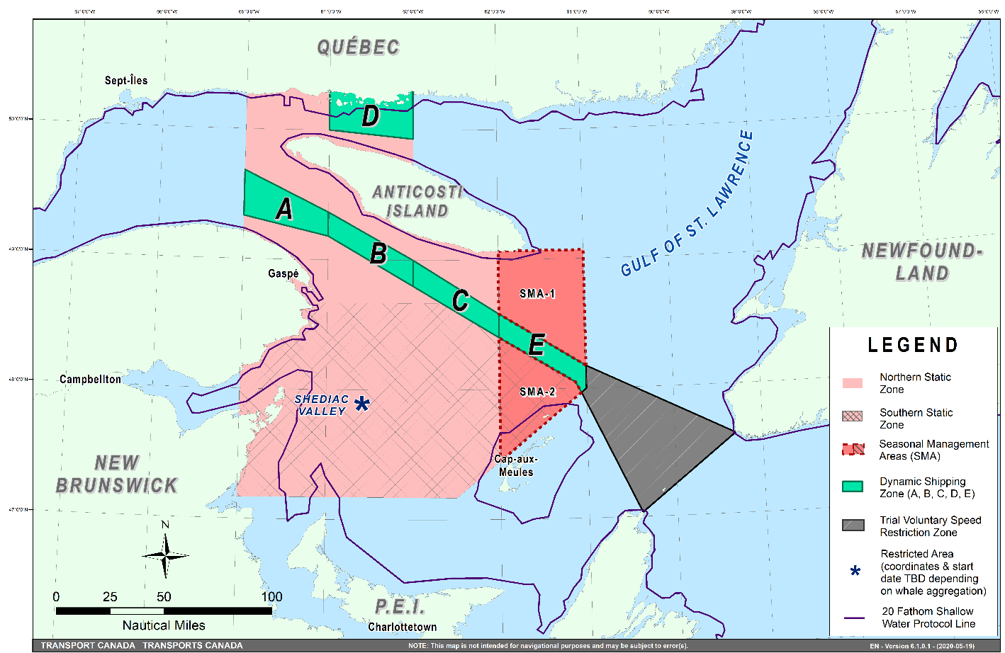
Map showing the two static zones (north and south), the five dynamic shipping zones (A, B, C, D and E), the seasonal management areas, the trial voluntary speed restriction zone and the 20 fathom shallow water protocol line.
This map is for visual representation only and is not to be used for navigation or enforcement.
NAVWARN broadcasts
The CCG-MCTS issues and publishes NAVWARNs:
•by
radio broadcast; and
•online
at Canada’s
Maritime Information Portal and its Navigational Warnings site.
Mariners must ensure they have accurate and up-to-date information about the protection of the North Atlantic right whale, as in all applicable NOTMARs and NAVWARNs.
For the North Atlantic right whale speed restriction, the NAVWARN that is currently in effect will be provided to vessels subject to the Vessel Traffic Services Zone Regulations or the Eastern Canada Vessel Traffic Services Zone Regulations:
Outbound vessels
•at
Calling-in-Point 10 (St-Laurent); or
•upon
a departure downstream from the Quebec pilot station
(including the Saguenay River, Chaleur Bay, Miramichi Bay,
etc.)
Inbound vessels
•when a clearance to enter Canadian waters is granted
Vessels in transit
•at
the last reporting point prior to entering the speed
restriction area; and/or
•at
10 nautical miles prior to entering the speed restriction
zone
For those vessels not subject to the above-mentioned regulations, vessel operators are required to monitor broadcasts by the Canadian Coast Guard’s Marine Communications and Traffic Services (MCTS) network for the most up to date information. For marine radio frequencies and broadcast times, information may be found in the Radio Aids to Marine Navigation publication.
Aids to navigation
The Canadian Coast Guard is currently testing virtual Automatic Identification System (AIS) aids to navigation (AIS AtoN) in specific areas. These aids notify mariners of a dynamic shipping zone subject to a speed restriction, per NOTMAR 819(T)/2016.
Each dynamic shipping zone is delimited by four virtual AIS AtoN, which can be displayed on a ship’s navigation equipment, such as
•Electronic
Chart Display and Information System (ECDIS);
•Electronic
Chart System (ECS);
•RADAR;
•Minimum
Keyboard Display (MKD); and
•Electronic
Nautical Chart (ENC).
The Canadian Coast Guard broadcasts the virtual AIS AtoN only when a speed restriction is in effect in one or more testing zones.
Mariners must select the virtual AIS AtoN symbol to view a message such as “SectA1 Spd Lim 10 kt.” This message refers to a speed restriction in effect for a specific zone.
Note: This system is not the primary way we communicate this information.
Compliance and enforcement
You must comply with the NAVWARNs broadcasted and published by the Canadian Coast Guard related to any Interim Order made pursuant to the Canada Shipping Act, 2001, aimed at regulating the navigation for the purposes of protecting the North Atlantic right whales.
If you do not comply with instructions in the NAVWARNs or in the Interim Orders, you could face:
•administrative
monetary penalties up to a maximum of CAN $250,000;
and/or
•penal
sanctions under the Canada Shipping Act, 2001.
If your vessel appears to have violated the speed restriction, Transport Canada Marine Safety inspectors will review all information provided through AIS and seek an explanation from the master.
No exemptions to the speed restriction will be granted in advance. However, if a deviation from the speed restrictions is necessary for safety reasons, the following information must be entered into the bridge logbook:
•Reasons
for deviation
•Speed
at which vessel is operated
•Latitude
and longitude at time of deviation
•Time
and duration of deviation
•Master
of the vessel shall sign and date the bridge logbook entry
For any deviation, Transport Canada will review and consider reasons such as
•Navigating
to ensure vessel safety;
•Weather
conditions;
•Force
majeure (unforeseeable circumstances); and
•Responding
to emergencies.
Report a North Atlantic right whale sighting
If you see a North Atlantic right whale that is entangled, injured or dead, please report it to your nearest Canadian Coast Guard Marine Communications and Traffic Services Centre, or as follows:
Southern part of the Gulf of St. Lawrence
Marine Animal Response Society
Telephone: 1-866-567-6277
Newfoundland and Labrador
Whale Release and Strandings
Telephone: 1-888-895-3003
For the Québec Sector
Marine Mammal Emergencies
Telephone: 1-877-722-5346
If you see live, free-swimming whales
•Call
1-902-440-8611 (local) or 1-844-800-8568 (toll free)
•Email:
XMARWhalesightings@dfo-mpo.gc.ca
Please consult WhaleMap for the latest right whale observations:
*506CANADIAN HYDROGRAPHIC SERVICE – MODIFICATIONS TO THE 2020 CANADIAN TIDE AND CURRENT TABLES, VOLUME 2 – GULF OF ST. LAWRENCE
The Canadian Hydrographic Service of the Quebec Region has identified a correction in the 2020 Canadian Tide and Current Tables, Volume 2, Gulf of St. Lawrence, on page 79.
Mariners should replace a section of Table 3 with the corresponding section annexed below:
https://www.notmar.gc.ca/publications/monthly-mensuel/images/ed052020-part1-vol2-p79.pdf
*507CANADIAN COAST GUARD PUBLICATION – AMENDMENTS TO NOTICES TO MARINERS ANNUAL EDITION 2020 - SECTION A2, NOTICE 5: GENERAL GUIDELINES FOR AQUATIC SPECIES AT RISK AND IMPORTANT MARINE MAMMAL AREAS
Several amendments have been made throughout this notice. The latest version of this notice can be found at the following link:
https://www.notmar.gc.ca/publications/annual-annuel/section-a/a5-en.pdf
*508CANADIAN COAST GUARD PUBLICATION – AMENDMENTS TO NOTICES TO MARINERS ANNUAL EDITION 2020 - SECTION A3, NOTICE 6: ICE NAVIGATION, ROUTEING AND REQUESTS FOR ICEBREAKER ASSISTANCE
Page 3:
AMEND
(b)For general information on ice conditions and icebreaker assistance in Chaleur Bay, New Brunswick, Prince Edward Island, Nova Scotia and Newfoundland and Labrador waters:
|
Telephone: |
709-772-2078 |
|
Toll-Free: |
1-800-565-1633 |
|
Facsimile: |
709-772-6640 (Business hours only) |
|
Email (24 hour assistance): |
|
|
Email (general inquiries): |
TO READ
(b)For general information on ice conditions and icebreaker assistance in Chaleur Bay, New Brunswick, Prince Edward Island, Nova Scotia and Newfoundland and Labrador waters:
|
Telephone: |
709-772-2078 |
|
Toll-Free: |
1-800-565-1633 |
|
Facsimile: |
709-772-6640 (Business hours only) |
|
Email (24 hour assistance): |
|
|
Email (general inquiries): |
*509(P)TADOUSSAC À/TO CAP ÉTERNITÉ – LIGHT BUOY TO BE DISCONTINUED
Reference Chart: 1203
The Canadian Coast Guard proposes to permanently discontinue the following aid to navigation:
|
Haut-fond Prince light and bell buoy SAGUE |
(LL 1774) |
(48° 07’ 08.8”N 069° 36’ 05.5”W) |
Comments on this action are solicited from mariners and other interested parties by August 28, 2020, three months following the initial publication date of May 29, 2020. Following this date, this notice will be cancelled. Comments should be directed to the following:
Superintendent, Mathieu Roy
Aids to Navigation & Waterways
Canadian Coast Guard
1550 D’Estimauville Avenue
Québec, QC G1J 5E9
Telephone: (418) 648-7450
Email: mathieu.roy@dfo-mpo.gc.ca
Any objections raised must state the facts on which they are based and should include supporting information on safety, commerce and public benefit.
(Q2020-070)
SECTION 2 - CHART CORRECTIONS
1203 - Tadoussac à/to Cap Éternité - New Edition - 17-JUN-2011 - NAD 1983
(See Chart No. 1, L25)
(See Chart No. 1, R14, R21)
1221 - Pointe de Moisie à/to Île du Grand Caoui - New Edition - 27-FEB-2015 - NAD 1983
(See Chart No. 1, L25)
1233 - Cap aux Oies à/to Sault-au-Cochon - New Edition - 11-MAY-2012 - NAD 1983
Download Patch - ftp://ftp.dfo-mpo.gc.ca/patches/pa1233_1_20200414.pdf
Download Patch - ftp://ftp.dfo-mpo.gc.ca/patches/pa1233_2_20200414.pdf
Download Patch - ftp://ftp.dfo-mpo.gc.ca/patches/pa1233_3_20200414.pdf
1234 - Cap de la Tête au Chien au/to Cap aux Oies - New Edition - 04-NOV-2011 - NAD 1983
(See Chart No. 1, L25)
1236 - Pointe des Monts aux/to Escoumins - New Edition - 26-OCT-2012 - NAD 1983
(See Chart No. 1, L25)
(See Chart No. 1, L25)
1312 - Lac Saint-Pierre - New Edition - 10-MAY-2019 - NAD 1983
(See Chart No. 1, Q81)
1315 - Québec à/to Donnacona - New Edition - 24-MAY-2019 - NAD 1983
Download Patch - ftp://ftp.dfo-mpo.gc.ca/patches/pa1315_20200420.pdf
(See Chart No. 1, K26)
(See Chart No. 1, K26)
(See Chart No. 1, I10)
(See Chart No. 1, I10)
(See Chart No. 1, I10)
1320 - Île du Bic au/to Cap de la Tête au Chien - New Chart - 26-AUG-2011 - NAD 1983
(See Chart No. 1, L25)
(See Chart No. 1, L25)
(See Chart No. 1, R14, R21)
2301 - Passage Island to/à Thunder Bay - New Edition - 22-FEB-1991 - US Standard Datum
(See Chart No. 1, K41)
2302 - St. Ignace Island to/à Passage Island - New Edition - 02-AUG-1985 - US Standard Datum
(See Chart No. 1, K41)
2303 - Jackfish Bay to St. Ignace Island - New Edition - 29-MAY-2015 - US Standard Datum
(See Chart No. 1, K41)
(See Chart No. 1, K41)
(See Chart No. 1, K41)
(See Chart No. 1, K41)
2304 - Oiseau Bay to/à Jackfish Bay - New Edition - 20-FEB-2004 - NAD 1983
(See Chart No. 1, K41)
2307 - Coppermine Point to/à Cape Gargantua - New Edition - 09-JUN-2006 - NAD 1983
(See Chart No. 1, K41)
(See Chart No. 1, K41)
2308 - Michipicoten Island to/à Oiseau Bay - New Edition - 22-SEP-2006 - NAD 1983
(See Chart No. 1, I10)
(See Chart No. 1, K41)
(See Chart No. 1, I10)
(See Chart No. 1, K41)
(See Chart No. 1, K41)
(See Chart No. 1, I10)
(See Chart No. 1, K41)
2309 - Cape Gargantua to/à Otter Head - New Edition - 23-JUL-1999 - NAD 1983
(See Chart No. 1, K41)
(See Chart No. 1, K41)
(See Chart No. 1, K41)
(See Chart No. 1, K41)
(See Chart No. 1, K41)
(See Chart No. 1, K41)
(See Chart No. 1, K41)
(See Chart No. 1, K41)
(See Chart No. 1, K41)
(See Chart No. 1, K41)
(See Chart No. 1, I10)
(See Chart No. 1, I10)
(See Chart No. 1, I10)
2312 - Nipigon Bay and Approaches/et les approches - New Edition - 31-MAY-2002 - NAD 1983
(See Chart No. 1, K41)
(See Chart No. 1, K41)
2313 - Black Bay - New Edition - 29-OCT-2004 - NAD 1983
(See Chart No. 1, K41)
2315 - Michipicoten Harbour - New Edition - 07-JUL-2006 - NAD 1983
(See Chart No. 1, K41)
4002 - Golfe du Saint-Laurent / Gulf of St. Lawrence - New Edition - 30-OCT-2015 - NAD 1983
(See Chart No. 1, L25)
(See Chart No. 1, L25)
(See Chart No. 1, L25)
4013 - Halifax to / à Sydney - New Edition - 06-SEP-2002 - NAD 1983
(See Chart No. 1, Qf)
4015 - Sydney to / à Saint-Pierre - New Edition - 28-MAR-2003 - NAD 1983
(See Chart No. 1, Qd)
(See Chart No. 1, Qc, Qd)
4022 - Cabot Strait and approaches / Détroit de Cabot et les approches - New Edition - 17-JAN-2003 - NAD 1983
(See Chart No. 1, Qd)
(See Chart No. 1, P16)
(See Chart No. 1, Qc, Qd)
4023 - Northumberland Strait / Détroit de Northumberland - New Edition - 27-DEC-2002 - NAD 1983
(See Chart No. 1, Qf)
4024 - Baie des Chaleurs/Chaleur Bay aux/to Îles de la Madeleine - New Edition - 06-MAR-2015 - NAD 1983
(See Chart No. 1, L25)
4026 - Havre Saint-Pierre et/and Cap des Rosiers à/to Pointe des Monts - New Edition - 23-MAY-2014 - NAD 1983
(See Chart No. 1, L25)
(See Chart No. 1, L25)
4099 - Sable Island / Île de Sable: Western Portion / Partie Ouest - New Edition - 28-DEC-2001 - NAD 1983
(See Chart No. 1, Q58)
to 43°48′06.8″N 060°39′06.8″W
4202 - Halifax Harbour: Point Pleasant to / à Bedford Basin - New Edition - 26-FEB-2016 - NAD 1983
(See Chart No. 1, I10)
(See Chart No. 1, I10)
(See Chart No. 1, Q25)
(See Chart No. 1, Q25)
(See Chart No. 1, I10)
(See Chart No. 1, I10)
(See Chart No. 1, I10)
(See Chart No. 1, I10)
(See Chart No. 1, I10)
4230 - Little Hope Island to / à Cape St Marys - New Chart - 15-JUN-1990 - NAD 1983
(See Chart No. 1, P1)
4243 - Tusket Islands to / à Cape St Marys - New Edition - 11-OCT-2002 - NAD 1983
(See Chart No. 1, P1)
4245 - Yarmouth Harbour and Approaches / et les approches - New Edition - 19-NOV-1999 - NAD 1983
(See Chart No. 1, P1)
4386 - St. Margaret's Bay - New Edition - 16-JUL-2004 - NAD 1983
(See Chart No. 1, P16)
4405 - Pictou Island to / aux Tryon Shoals - New Edition - 21-FEB-2003 - NAD 1983
(See Chart No. 1, Qf)
(See Chart No. 1, Qc)
4419 - Souris Harbour and Approaches / et les approches - New Edition - 22-NOV-2002 - NAD 1983
(See Chart No. 1, Qf)
4466 - Hillsborough Bay - New Edition - 21-MAR-2003 - NAD 1983
(See Chart No. 1, Qf)
(See Chart No. 1, Qc)
4639 - Garia Bay and / et Le Moine Bay - New Edition - 10-MAY-2002 - NAD 1983
(See Chart No. 1, Qd)
4639 - Rose Blanche - New Edition - 10-MAY-2002 - NAD 1983
(See Chart No. 1, Qd)
4823 - Cape Ray to / à Garia Bay - New Chart - 16-JAN-2004 - NAD 1983
(See Chart No. 1, Qd)
4824 - Garia Bay to / à Burgeo - New Chart - 25-OCT-2002 - NAD 1983
(See Chart No. 1, Qc, Qd)
4858 - Valleyfield - New Chart - 25-DEC-1998 - NAD 1983
(See Chart No. 1, I10, I3.2)
4885 - Port Harmon and Approaches / et les approches - New Edition - 08-MAR-2002 - NAD 1983
(See Chart No. 1, F4.1)
and 48°25′53.9″N 058°29′08.1″W
(See Chart No. 1, P1)
(See Chart No. 1, P1)
4885 - St. George's Public Wharf / Quai public - New Edition - 08-MAR-2002 - NAD 1983
(See Chart No. 1, F4.1)
48°25′52.6″N 058°29′10.1″W
and 48°25′53.9″N 058°29′08.1″W
(See Chart No. 1, P1)
(See Chart No. 1, P1)
6424 - Bryan Island to/à Travaillant River Kilometre 1240 / Kilomètre 1325 - New Edition - 30-JAN-2015 - World Geodetic System 1984
(See Chart No. 1, Qg)
to 67°28′14.2″N 130°55′37.7″W
(See Chart No. 1, Qg)
to 67°27′51.5″N 130°54′17.0″W
(See Chart No. 1, Q120)
(See Chart No. 1, Q120)
(See Chart No. 1, Q120)
(See Chart No. 1, Q120)
(See Chart No. 1, Qt)
(See Chart No. 1, Qg)
(See Chart No. 1, Qf)
(See Chart No. 1, Qg)
(See Chart No. 1, Qf)
(See Chart No. 1, Qf)
(See Chart No. 1, Qf)
(See Chart No. 1, Qf)
(See Chart No. 1, Qg)
to 67°12′06.2″N 130°16′19.5″W
8007 - Halifax to / à Sable Island / Île de Sable, Including / y compris Emerald Bank / Banc d'Émeraude and / et Sable Island Bank / Banc de l'Île de Sable - New Edition - 30-AUG-2002 - NAD 1983
(See Chart No. 1, Q58)
(See Chart No. 1, Q58)
to 43°48′06.8″N 060°39′06.8″W
SECTION 3 - RADIO AIDS TO MARINE NAVIGATION CORRECTIONS
*513RADIO AIDS TO MARINE NAVIGATION 2020 (ATLANTIC, ST. LAWRENCE, GREAT LAKES, LAKE WINNIPEG, ARCTIC AND PACIFIC)
Page 1-12
ADD AS FOLLOWS:
1.6ICEBREAKING SERVICES
Ice Atlantic
Telephone:709-772-2078
Email: iceatl@dfo-mpo.gc.ca
Page 4-84
AMEND AS FOLLOWS:
Yarmouth, Nova Scotia
Senior
Technologist
Fisheries and Oceans
Canada
Canadian Coast
Guard
P.O. Box
37
Yarmouth, NS B5A
4B1
Telephone:902-407-7521
Facsimile: 902-407-7435
Email: xmartsc@dfo-mpo.gc.ca
CCG Central and Arctic Region (Ontario)
Telephone: 613-925-4842
Email:
TSCCNA@dfo-mpo.gc.ca
•In the subject of the email, please state: SRI – "Ship's Name"
•In the body of the email, please include any contact information for the vessel.
CCG Central and Arctic Region (Québec and Ontario)
Fisheries and Oceans Canada
Telephone: 514-283-5684
Email: spvr.email@stericycle.com
SECTION 4 - SAILING DIRECTIONS AND SMALL CRAFT GUIDE CORRECTIONS
Chapter 11 — Paragraph 80
Delete:“ The crossing is marked by reciprocal beacon ranges with RAMs at Kilometres 1280.1 and 1278.5. ”
(C2020-007.1)
Chapter 11 — Paragraph 80
Insert:A starboardhand daybeacon with a RAM is located near Kilometre 1285 on the west side of the river.
(C2020-007.2)
Chapter 1 — Paragraph 117, after “…clearance of 2.3 m.”
Delete: “
A light (257)…on the bridge. ”
(A2020-006.2)
Chapter 3 —Paragraph 138, after “Starboard hand light…”
Delete: “ and bell ”
(A2020-008.2)
Chapter 3 —Paragraph 157, after “…along the west face.”
Insert:A light (1008.2) is shown from a mast, having a green, white and black daymark, on the outer end of the wharf.
(A2020-008.3)
Chapter 3 — Adjacent to paragraph 157, add a light pictograph.
(A2020-008.4)
Chapter 3 —Paragraph 160
Delete:“ A
light is shown…village of Victoria. ”
Replace by:A
tower, resembling a light structure is situated in the village of
Victoria.
(A2020-008.5)
Chapter 3 — Adjacent to paragraph 160, delete the light pictograph.
(A2020-008.6)
Chapter 1 — Paragraph 136
Delete: “ is shown from a red and white mast with two fluorescent-orange
daymarks ”
Replace by: is placed on a tower with three fluorescent-orange daymarks with a black stripe,
(Q2020-016.1)
Chapter 1 — Paragraph 138
Delete: “ longitude 70°52'W ”
Replace by: latitude 47°05'N
(Q2020-016.2)
Chapter 1 — Paragraph 139
Delete: “ 7.1 m ”
Replace by: 5.9 m
(Q2020-016.3)
Chapter 1 — Paragraph 140, after “a fluorescent-orange daymark”
Insert: with a black stripe
(Q2020-016.4)
Chapter 1 — At the end of paragraph 141
Add: with a black stripe
(Q2020-016.5)
Chapter 1 — Delete paragraph 143
Replace by: 143 The lower leading lights of Banc du Cap Brûlé, in line bearing 213½°, lead into the Chenal du Nord off Cap Maillard (see Chart 1233). The front light (1898) is shown from a white and red tower on a wide pillar and also has a fluorescent-orange daymark with a black stripe located on a shoal (47°06'N, 70°42'W). The rear light (1899) is located on a white tower with a red upper portion on a wide pillar and has a racon (— • —) and a fluorescent-orange daymark with a black stripe. The lights are visible only when in alignment.
(Q2020-016.6)
Chapter 2 — Paragraph 5
Delete: “ longitude 70°52'W ”
Replace by: latitude 47°05'N
(Q2020-016.7)
Chapter 2 — Paragraph 17
Delete: “ 9.4 m ”
Replace by: 9.7 m
(Q2020-016.8)
Chapter 2 — Paragraph 20
Delete: “ 590 m ”
Replace by: 563 m
(Q2020-016.9)
Chapter 2 — Paragraph 28, after “The light has fluorescent-orange
daymarks on three sides”
Insert: with a black stripe
(Q2020-016.10)
Chapter 2 — Paragraph 33
Delete: “ 9.9 to 12.5 m ”
Replace by: 10.4 to 12.3 m
(Q2020-016.11)
Chapter 2 — Delete paragraph 45
Replace by: 45 The village of Sainte-Pétronille, population 1,033, is located near the SW end of Île d’Orléans. The village is bordered by a long breakwater along the coast all the way to a large, white inn to the south. The Sainte-Pétronille light (1927) is located on a tower on the south end of the breakwater near the inn. (46°51'N, 71°08'W).
(Q2020-016.12)
Chapter 2 — Paragraph 47
Delete: “ 3.6 m ”
Replace by: 3.9 m
(Q2020-016.12)
Chapter 2 — Paragraph 48
Delete: “ private wharf ”
Replace by: wharf in ruins
(Q2020-016.14)
Chapter 2 — Paragraph 52
Delete: “ a private wharf, 375 m long,… exclusively by
local tour boats. ”
Replace by: a wharf in ruins.
(Q2020-016.15)
Chapter 2 — Paragraph 53
Delete: “ Sainte-Famille ”
Replace by: Sainte-Famille-de-l’Île-d’Orléans
(Q2020-016.16)
Chapter 2 — Paragraph 56
Delete: “ Sainte-Famille ”
Replace by: Sainte-Famille-de-l’Île-d’Orléans
(Q2020-016.17)
Chapter 2 — Paragraph 104
Delete: “ There is a dolphin and two circular cribs ”
Replace by: There are two dolphins
(Q2020-016.18)
Chapter 2 — Paragraph 104
Delete: “ 8.2 m ”
Replace by: 8.1 m
(Q2020-016.19)
Chapter 2 — Delete paragraph 110.1
Replace by: 110.1 White lights in line (private) (12696, 12697) with yellow daymarks mark the limit of the dredged area 12.4 m alongside Berth 86. Two other orange daymarks with red lights (12698, 12699) still exist, but there is no longer a dredged area at this location.
(Q2020-016.20)
Chapter 2 — Delete paragraph 115
(Q2020-016.21)
Chapter 2 — Paragraph 126
Delete: “ 15.1 m ”
Replace by: 15.5 m
(Q2020-016.22)
Chapter 3 — Paragraph 5
Delete: “ longitude 70°52'W ”
Replace by: latitude 47°05'N
(Q2020-016.23)
Chapter 3 — Paragraph 108
Delete: “ longitude 70°52'W ”
Replace by: latitude 47°05'N
(Q2020-016.24)
Chapter 3 — Delete paragraph 113
(Q2020-016.25)
Chapter 3 — Paragraph 132
Delete: “ 1.7 m ”
Replace by: 1.8 m
(Q2020-016.26)
Chapter 3 — Paragraph 137
Delete: “ 46°56'N ”
Replace by: 46°57'N
(Q2020-016.27)
SECTION 5 - LIST OF LIGHTS, BUOYS AND FOG SIGNALS CORRECTIONS
The amendments are highlighted and deletions are crossed out. For general and region-specific
information on the List of Lights, click on the following links:
Newfoundland and Labrador Coast,
Atlantic Coast,
Inland Waters and
Pacific Coast.
NEWFOUNDLAND AND LABRADOR COAST
| No. | Name |
Position ----- Latitude N. Longitude W. |
Light Characteristics |
Focal Height in m. above water |
Nominal Range |
Description ----- Height in meters above ground |
Remarks ----- Fog Signals |
|||
|---|---|---|---|---|---|---|---|---|---|---|
ST. MARY'S BAY (LL 7.5 – 14) |
||||||||||
| 11 | Branch Cove light buoy MB3 |
46 52 39.3 053 56 50.9 |
Fl | G | 4s | ..... | ..... |
Green |
Year round. Chart:4842 Edn 05/20 (N20-022) |
|
SOUTHWEST COAST (LL 121 – 172) |
||||||||||
| 145.8 | La Poile Approach light and bell buoy QE2 |
47 37 37.3 058 23 11.4 |
Fl | R | 4s | ..... | ..... | Red, marked “QE2”. |
Year round. Chart:4824 Edn 05/20 (N20-030) |
|
| 148.9 |
Rose Blanche light |
47 35 28.1 058 41 42.8 |
Mo(A) | W | 6s | ….. | ….. | Red and white vertical stripes, marked “QRB”. |
Operates 24
h. Year round. Chart:4639 Edn 05/20 (N20-012) |
|
WEST COAST (LL 173 – 208.2) |
||||||||||
|
183 H0214 |
St. George's Cautionary Light |
48 25 53.9 058 29 08.1 |
Fl | Y | 4s | 3.0 | ….. |
Mast. 2.6 |
Flash 1 s; eclipse 3 s. Seasonal. Chart:4885 Edn 05/20 (N20-006) |
|
ATLANTIC COAST
| No. | Name |
Position ----- Latitude N. Longitude W. |
Light Characteristics |
Focal Height in m. above water |
Nominal Range |
Description ----- Height in meters above ground |
Remarks ----- Fog Signals |
|||
|---|---|---|---|---|---|---|---|---|---|---|
BAY OF FUNDY, N.S. (LL 163 – 268) |
||||||||||
|
257 H3834 |
Yarmouth Bar Breakwater |
Delete from
list. Chart:4245 Edn 05/20 (F20-010) |
||||||||
NOVA SCOTIA, SOUTHEAST COAST (LL 327 – 684.02) |
||||||||||
|
407 H3735 |
Coffin Island |
44 02 03.5 064 37 42.5 |
Fl | W | 4s | 14.9 | 6 | White cylindrical tower with red top. |
Flash 1 s; eclipse
3 s. Year round. Chart:4379 Edn 05/20 (F20-012) |
|
|
488 H3658 |
West Dover Light |
On S. end of Callahan Island. 44 29 24.3 063 51 40.7 |
Fl (2+1) | G | 6s | 15.2 | 4 |
Pipe swing
pole, red and white rectangular daymark with red diamond and green
square in the centre. 6.1 |
Year round. Chart:4386 Edn 05/20 (F20-011) |
|
|
629.9 H3516.4 |
Mouton Harbour Wharf Light |
45 05 41.8 061 43 35.1 |
Fl | G | 4s | 4.3 | 4 |
Cylindrical mast, green and white square
daymark.
3.5 |
Flash 1 s; eclipse
3 s. Year round. Chart:4234 Edn 05/20 (G20-018) |
|
CAPE BRETON ISLAND, N.S. (LL 704.85 – 882.5) |
||||||||||
|
722 H3376 |
Green Island Light |
Summit of island. 45 28 41.3 060 53 57.6 |
Fl(2) | W | 20s | 34.1 | 10 |
White cylindrical tower with red upper
portion. 11.5 |
Flash 1 s;
eclipse 3
s; flash 1 s; eclipse 15 s. Year round. Chart:4301 Edn 05/20 (G20-016) |
|
PRINCE EDWARD ISLAND (LL 942 – 1084.7) |
||||||||||
| 984 |
Prim Reefs light |
Off W. extremity of reefs. 46 02 40.3 063 06 47.6 |
Q | R | 1s | ….. | ….. |
Red spar, marked “ |
Seasonal. Chart:4466 Edn 05/20 (G20-029) |
|
| 989 |
Fitzroy Rock light |
SW. of rock. 46 07 05.8 063 06 39.5 |
Fl | R | 4s | ….. | ….. |
Red, marked “ |
(Winter spar.) Seasonal. Chart:4466 Edn 05/20 (G20-030) |
|
| 1027.42 | Higgins Wharf light buoy DJ16 |
46 33 25.1 064 05 38.0 |
Q | R | 1s | ….. | ….. | Red, marked “DJ16”. |
Seasonal. Chart:N/A Edn 05/20 (G20-022) |
|
| 1027.425 | Higgins Wharf light buoy DJ15 |
46 33 26.8 064 05 39.7 |
Fl | G | 4s | ….. | ….. | Green, marked “DJ15”. |
Seasonal. Chart:N/A Edn 05/20 (G20-021) |
|
| 1027.43 | Higgins Wharf light buoy DJ30 |
46 33 19.3 064 05 11.0 |
Fl | R | 4s | ….. | ….. | Red, marked “DJ30”. |
Seasonal. Chart:N/A Edn 05/20 (G20-020) |
|
| 1027.45 | Higgins Wharf light buoy DJ |
46 33 23.1 064 06 38.5 |
Mo(A) | W | 6s | ….. | ….. | Red and white vertical stripes, marked “DJ”. |
Seasonal. Chart:4905 Edn 05/20 (G20-019) |
|
ST. LAWRENCE RIVER (LL 1584.5 – 1772, 1823.8 – 2185.7, 2273 – 2365.95) |
||||||||||
| 1731 | Port de Rimouski light and bell buoy H41 |
Channel
entrance. 48 30 28.1 068 31 04.1 |
Fl | G | 4s | ..... | ..... | Green, marked “H41”. |
Seasonal. Chart:1236 Edn 05/20 (Q20-069) |
|
| 1732.2 | Port de Rimouski light buoy HT3 |
Quai de
Rimouski 48 29 25.3 068 31 07.4 |
Fl | G | 4s | ..... | ..... | Green, marked “HT3”. |
Seasonal. Chart:1236 Edn 05/20 (Q20-068) |
|
| 1732.4 | Port de Rimouski light buoy HT10 |
Quai de
Rimouski approach. 48 28 49.6 068 31 10.5 |
Q | R | 1s | ..... | ..... | Red, marked “HT10”. |
Seasonal. Chart:1236 Edn 05/20 (Q20-047) |
|
| 1771 |
Batture aux Alouettes light |
Saguenay River
Entrance. 48 03 30.1 069 38 36.2 |
Q | R | 1s | ..... | ..... | Red, marked “K58”. |
(Winter spar.) Year round. Chart:1203 Edn 05/20 (Q20-033) |
|
INLAND WATERS
| No. | Name |
Position ----- Latitude N. Longitude W. |
Light Characteristics |
Focal Height in m. above water |
Nominal Range |
Description ----- Height in meters above ground |
Remarks ----- Fog Signals |
|||
|---|---|---|---|---|---|---|---|---|---|---|
ST. LAWRENCE RIVER SEAWAY (LL 0.05 - 401, 1193 – 1204.5) |
||||||||||
| 5.3 | Pointe Bell light buoy A2 |
45 24 27.7 073 43 24.2 |
Q | R | 1s | ..... | ..... | Red spar, marked “A2”. |
Seasonal (in
place year round). Chart:1429 Edn 05/20 (Q20-024) |
|
| 6 | Pointe Johnson light buoy A3 |
45 24 17.1 073 43 44.1 |
Q | G | 1s | ..... | ..... | Green spar, marked “A3”. |
Seasonal (in place year round). Chart:1429 Edn 05/20 (Q20-027) |
|
| 7 | Pointe Johnson light buoy A4 |
45 24 22.7 073 43 51.9 |
Q | R | 1s | ..... | ..... | Red spar, marked “A4”. |
Seasonal (in place year round). Chart:1429 Edn 05/20 (Q20-028) |
|
| 11 | Île Saint-Bernard light buoy A9 |
45 24 13.2 073 45 21.2 |
Fl | G | 4s | ..... | ..... | Green spar, marked “A9”. |
Seasonal (in place year round). Chart:1430 Edn 05/20 (Q20-031) |
|
| 13 | Île Saint-Bernard light buoy A13 |
45 24 10.7 073 46 22.1 |
Q | G | 1s | ..... | ..... | Green spar, marked “A13”. |
Seasonal (in place year round). Chart:1430 Edn 05/20 (Q20-043) |
|
| 15 | Île Saint-Bernard light buoy A17 |
45 24 04.7 073 46 48.2 |
Q | G | 1s | ..... | ..... | Green spar, marked “A17”. |
Seasonal (in place year round). Chart:1430 Edn 05/20 (Q20-044) |
|
| 17 | Île Saint-Bernard light buoy A21 |
45 23 54.8 073 47 10.6 |
Q | G | 1s | ..... | ..... | Green spar, marked “A21”. |
Seasonal (in place year round). Chart:1430 Edn 05/20 (Q20-049) |
|
| 18 | Île Saint-Bernard light buoy A20 |
45 23 54.1 073 47 23.2 |
Fl | R | 4s | ..... | ..... | Red spar, marked “A20”. |
Seasonal (in place year round). Chart:1430 Edn 05/20 (Q20-045) |
|
RAINY LAKE (LL 1445 – 1468) |
||||||||||
| 1450 | Capstan Reef |
On reef, E. of Sand Point. 48 38 05.7 093 02 58.9 |
Fl | W | 4s | ….. | 5 |
Mast, white
cylindrical
daymark. 5.4 |
Seasonal. Chart:6109 Edn 05/20 (D20-018) |
|
CANADIAN COAST GUARD - MARINE INFORMATION REPORT AND SUGGESTION SHEET
Name of Ship or Sender:..................................................................... Date:....................................
Address of Sender:..........................................................................................................................
Street # Street Name
Town / City:.............................. Prov / State:....................... Postal Code / Zip Code: ........................
Tel / Fax / E-mail address of sender (if appropriate):............................................................................
Observation Date:............................................. Time (UTC): ...........................................................
Geographical Position:......................................................................................................................
Coordinate Position: Lat: ............................................... Long:.........................................................
Position Method: DGPS GPS with WAAS GPS Radar Other
Horizontal Datum Used: WGS 84 NAD 27 Other
Estimated Position Accuracy:............................................................................................................
Chart #:............................................................ Datum: NAD 27 NAD 83
Chart Edition:.................................................... Last Correction applied:............................................
Publications affected: (Quote edition and page number):.....................................................................
*Full details (Attach additional sheets as necessary):...........................................................................
Mariners are requested to notify the responsible authorities when new or suspected dangers to navigation are discovered, changes are observed in aids to navigation, or corrections to publications are seen to be necessary.
In the case of new or suspected dangers to navigation, it is important that all details be given in order to aid with future investigations. Items of interest include heights, depths, physical description, type of bottom and equipment method used to position the item. It is helpful to mark details on the chart, which will be promptly replaced by the Canadian Hydrographic Service.
Reports should be made to the nearest Marine Communications and Traffic Services Centre (MCTS) and should be confirmed in writing to:
Leader, Notices to Mariners
Canadian Coast Guard
Department of Fisheries and Oceans
Montréal, QC H2Y 2E7
In the case of information concerning aids to navigation or the List of Lights, Buoys and Fog Signals book.
OR
Director General, Canadian Hydrographic Service & Oceanographic Services
Department of Fisheries and Oceans
Ottawa, ON K1A 0E6
In the case of new or suspected dangers to navigation or where corrections to "Sailing Directions" appear to be necessary.
For general questions on Canadian Coast Guard programs or services, please send an e-mail to:
info@dfo-mpo.gc.ca (Please include your postal code and e-mail address).
You can access the online form on the following page: https://www.notmar.gc.ca/incident-en.php or you can use the printable pdf version : https://www.notmar.gc.ca/publications/monthly-mensuel/images/monthly-form-en.pdf