
40Contamination Prediction System for Merchant Ships at Sea and the MERWARN System
Ref: NATO ATP-45
1Introduction
Radioactive fallout from nuclear explosions and chemical and biological contamination (hereafter collectively referred to as contamination) on sea and land targets, particularly from the latter, may affect large areas of adjacent waters. The areas affected will depend upon the prevailing wind conditions, and any ship close to or approaching these areas will be in grave danger. It is therefore essential that shipping should be warned of the fallout hazards and contamination in order that:
(a)Passive defence measures, such as switching on
washdown systems, may be taken.
(b)Course may be altered, if necessary, to avoid the
dangerous zones.
2Danger zones
All shipping in waters out to 200 nautical miles from any coast at the outset of nuclear release must be regarded as being in an area of possible fallout danger from that release on shore.
3Ground zero (GZ)
The point on the surface of the earth at, or vertically below or above, the centre of a planned or actual nuclear detonation (GZ).
4The MERWARN System - Warnings to Merchant Ships at Sea.
A simplified contamination warning system has been established throughout NATO for broadcasting, via MERCOMMS and coastal radio stations, warnings of contamination dangerous to merchant shipping. This system calls for the origination, by NATO naval authorities, of five types of messages:
(a)MERWARN NBC
Effective Downwind Message (MERWARN NBC EDM). The
MERWARN NBC EDM is a prediction, for a specified sea area and
time interval, of the fallout, which will result from a
one megaton (1 MT) nuclear surface explosion. It will
give the master of a ship, observing a nuclear explosion, an
immediate indication of the area likely to be affected by
fallout.
(b)MERWARN
NBC 3 NUC. The MERWARN NBC 3 NUC will be
issued after a nuclear attack and gives fallout data for a
specific nuclear explosion or series of explosions, which will
be identified in the message.
(c)MERWARN NBC
Chemical Downwind Message, (MERWARN NBC CDM). This
contains a forecast of the meteorological data needed for the
chemical hazard area prediction procedure.
(d)MERWARN
NBC 3 CHEM. This message is issued to pass
immediate warning of a predicted chemical contamination and
hazard area.
(e)MERWARN
DIVERSION ORDER. This is a general diversion order,
based upon the fallout threat, whereby merchant ships
proceeding independently are passed evasive routing
instructions of a general nature.
Note: In some cases it may be better to provide warning of contamination by means of general plain language messages rather than by the formats above. The messages in a., b. and c. above are explained in more detail in the following paragraphs. Biological procedures for shipping are the same as for land and are described in Chapter 9 to the NATO ATP-45.
5MERWARN Originating and Diversion Authorities.
MERWARN Originating and Diversion authorities will be designated
by national or NATO commanders before commencement of
operations.
6Precedence of NBC Messages.
All MERWARN NBC messages should be given the precedence FLASH (Z) to ensure rapid handling on any military circuit between the originating authority and the MERCOMMS and/or coastal radio stations. This precedence should not be used where the rules for the use of the International Safety Signal (TTT for CW and Security for voice circuits) apply. (See para 7).
7Method of Promulgation.
All MERWARN NBC EDM, MERWARN NBC CDM, MERWARN NBC 3 CHEM and NBC 3 NUC messages will be transmitted in plain language, using GMT, preceded by the International Safety Signal (TTT for CW and Security for voice circuits) from the appropriate MERCOMMS station and from all the coastal radio stations of the area concerned. Thus masters need not concern themselves with the identity of the MERWARN originators, but only with the sea areas covered by each message.
8Relay Responsibilities.
Originating authorities are responsible for relaying to:
(a)The appropriate Coast Earth Station (INMARSAT) (CES),
Coast Radio Station (CRS) under their control and/or other CRS
in their geographic area.
(b)Their own national authorities (for transmission to
merchant ships not yet copying MERCOMMS).
(c)Adjacent MERWARN originators and shipping diverting
authorities within the geographical area affected by each
MERWARN NBC 3 NUC message.
Note: Adjacent MERWARN originators are responsible for relaying to CES/CRS under their control as necessary.
9MERWARN EDM
MERWARN NBC EDM is a prediction, for a specified sea area and time interval, of the fallout, which will result from a one megaton (1 MT) nuclear surface explosion. It will give the master of a ship, observing a nuclear explosion, an immediate indication of the area likely to be affected by fallout. MERWARN NBC EDM will be issued at 12 hour intervals from the time of activation of the MERCOMMS system, and will be valid 12 hours ahead from the date and time given in the first line of the message (A). In the event of changing meteorological conditions it may be necessary for the originating authorities to issue MERWARN NBC EDM more frequently. The original MERWARN NBC EDM will automatically be overruled by the latest MERWARN EDM issued. The following standard format will be used:
(a)Message identifier (MERWARN NBC EDM) and
date-time-group (GMT) from which valid for 12 hours
ahead.
(b)Specified sea area for which valid.
(c)Effective downwind direction (degrees, 3 digits)
and effective downwind speed (knots, 3 digits).
(d)Downwind distance of Zone I (nautical miles,
3 digits).
(e)Additional information.
Example:
(a)MERWARN NBC EDM 180600ZSEP1999
(b)Baltic Sea west of 15° 00'E
(c)045 - 020
(d)078
(e)NIL.
Note: Sets (b)., (c). and (d). may be repeated
for different sea areas should this be considered
necessary.
10MERWARN NBC 3 NUC, Standard Format
MERWARN NBC 3 NUC will be issued after a nuclear attack producing fallout, and gives fallout data for a specific explosion or series of explosions, which will be identified in the message. MERWARN NBC 3 NUC messages are issued as soon as possible after the attack, and at six hour intervals (to the nearest hour) thereafter, for as long as the fallout danger exists. They contain information, which enables the master of a ship to plot the danger area. The standard format of MERWARN NBC 3 NUC contains the sets ALFA, DELTA, FOXTROT and PAPAB of the military NBC 3 NUC message (see ATP-45, Chapter 2). The MERWARN NBC 3 NUC has the following structure:
MERWARN NBC 3 NUC (Message identifier)
ALFA: Strike Serial Number (as defined by the naval
authority)
DELTA: Date-time Group of detonation (GMT)
FOXTROT: Location of attack (latitude and longitude, or
geographical place name) and qualifier (2 digits as to
refer in ATP-45, Annex C, para C.17).
PAPAB:Effective wind speed (3 digits and unit of
measurement), downwind distance of Zone I (3 digits
and unit of measurement), cloud radius (2 digits and unit
of measurement), left and right radial line of the predicted
fallout hazard area (3 digits and unit of measurement
each).
Example:
MERWARN NBC 3 NUC
ALFA/UK/NBCC/02-001/N//
DELTA/021405ZSEP1999//
FOXTROT/451230N014312E/AA//
PAPAB/012KTS/028NM/02NM/272DGT/312DGT//
11MERWARN NBC 3 NUC, Plain Language Format.
The MERWARN NBC 3 NUC standard format may not be suitable after a multiple nuclear attack, which produces fallout from several bursts in a large or complex target area. In such cases warnings will be plain language statements of a more general nature, indicating area affected and expected movement of the fallout.
Example 1:
MERWARN NBC 3 NUC
ALFA/UK/02-001/N//
DELTA/021405ZSEP1999//
Fallout extends from Glasgow area to eastern Ireland at 021405Z
and is spreading westwards with 12 Knots. Irish Sea is
likely to be affected within an area of 60 nautical miles
of the British coast.
Example 2:
MERWARN NBC 3 NUC
ALFA/IT/15-001/N//
DELTA/150630ZFEB1999//
Fallout is estimated to be occurring at 150830Z over Adriatic Sea east of the coast line Bari/Brindisi up to a distance of 30 nautical miles. Fallout is moving south-eastwards with 016 Knots, getting weaker. It is not expected to be dangerous after 151000Z.
12MERWARN NBC CDM.
The MERWARN NBC CDM message contains information needed for CHEM/BIO hazard prediction by the master of a merchant ship. The MERWARN NBC CDM will be issued as required via the MERCOMMS and will be valid as specified. In the event of changes in the meteorological conditions, the MERWARN NBC CDM will be updated as required.
(a)The following standard format will be used:
ALFA:Message identifier (MERWARN NBC CDM), date/time
group (GMT) from which valid 6 hours ahead.
BRAVO:Specified sea area for which valid.
CHARLIE: Representative downwind direction (degrees,
3 digits) and representative downwind speed (knots,
3 digits).
DELTA:Maximum downwind hazard distance (nautical miles,
3 digits).
ECHO:Additional information.
Example:
ALFAMERWARN NBC CDM 180600ZSEP1999//
BRAVOBALTIC SEA WEST OF 15°00'E//
CHARLIE045/020//
DELTA010//
ECHONIL//
13MERWARN NBC 3 CHEM.
MERWARN NBC 3 CHEM. This message is issued to pass immediate warning of a predicted chemical contamination and hazard area. MERWARN NBC 3 CHEM reports are issued as soon as possible after each attack. They contain sufficient information to enable the master of a ship to plot the downwind hazard area.
(a)The following standard format will be used for MERWARN NBC 3 CHEM:
MERWARN NBC 3 CHEM(Message identifier)
ALFA:Strike serial number (as defined by naval authority).
DELTA:Date/time group (Z) of start and end of
attack.
FOXTROT:Location of event.
GOLF:Delivery Means.
INDIA:Release Information.
PAPAA:Predicted attack and hazard area.
Note: If representative downwind speed is 5 knots or less, or variable, this letter item will consist of three (3) digits instead of coordinates, representing the radius of a circle in nautical miles centred on the location of the attack contained in set FOXTROT.
YANKEE:The representative downwind direction and speed.
ZULU:Information on actual weather conditions.
GENTEXT: Remarks
Note: Some of the letter items above may not be completed in the report that is received, but there will be sufficient information for a Downwind Hazard plot to be carried out.
(b)The MERWARN NBC 3 CHEM standard format may not be suitable after a multiple chemical attack, which produces a hazard from several attacks or depositions in a large or complex target area. In such cases warnings will be plain language statements of a more general nature, indicating areas affected and expected movement of the hazard.
Example 1:
MERWARN NBC 3 CHEM
ALFA/DA/NBCCC-4/003/C//
DELTA/020300ZSEP1999//
GENTEXT/PERSISTENT NERVE AGENT VAPOUR HAZARD EXISTS FROM
NORFOLK TO HATTERAS AT 020300Z SEP 1999 AND IS SPREADING
SOUTH-EASTWARDS AT 017 KNOTS. SEA AREA OUT TO
100 NAUTICAL MILES FROM COAST LIKELY TO BE AFFECTED BY
020600ZSEP1999//
Example 2:
MERWARN NBC 3 CHEM
ALFA/DA/NBCC-3/003/C//
DELTA/020300ZSEP1999//
GENTEXT/PERSISTENT NERVE AGENT VAPOUR HAZARD AT 020600 SEP 99
IS ESTIMATED TO BE OCCURRING OVER MOST OF THE SEA AREAS OUT TO
40 MILES EAST OF THE COAST LINE FROM NORFOLK TO HATTERAS.
HAZARD IS EXPECTED TO HAVE DISPERSED BY 021000Z SEP1999//
14MERWARN DIVERSION ORDER.
In addition to the origination of MERWARN NBC EDM and MERWARN NBC 3 NUC messages, naval authorities may, if circumstances dictate, broadcast general diversion orders, based upon the fallout threat, whereby merchant ships proceeding independently will be passed evasive routing instructions of a more general nature, using the standard Naval Control of Shipping (NCS) identifier MERWARN DIVERSION ORDER.
(a)MERWARN DIVERSION ORDER
(b)English Channel closed. All shipping in North Sea
remain north of 052 degrees N until 031500ZSEP1999.
15Other Warnings.
ATP-2, VOL II, gives instructions for the display of signals by ships, which have received a MERWARN NBC 3 NUC message, which affects their area. Ships arriving from sea but remaining beyond visual/aural range of shore stations should continue to keep radio watch in order to receive MERWARN Messages.
APPENDIX "A"
MERWARN Fall-out Plotting - Action by Masters
1Effective Downwind Direction and Downwind Speed.
Winds in the atmosphere vary considerably with height, both in direction and speed, and have a major influence on the distribution of radioactive fallout from a nuclear cloud. The worst contamination will fall to the surface along a path represented by the average wind between the surface and the middle of the nuclear cloud. Based upon meteorological information on the wind conditions in the air space between the surface and the height of the nuclear cloud, NBC Collection Centres will compute the average direction and speed of the radioactive particles' path from the nuclear cloud to the surface. The results of this computation make the fallout prediction, expressed in the terms of effective downwind direction and wind speed. It should be noted that the direction of the effective downwind is the direction towards which the wind blows. This direction is also known as the fallout axis. The surface wind will usually be considerably different from the effective downwind, both in direction and speed, and the surface wind should never be used to estimate the drift of fallout.
2The fall-out pattern criteria
The predicted fallout area consists of two zones, Zone I and II, the criteria of which are:
(a)Zone I is the zone of immediate concern. Within
this zone there will be areas where exposed, unprotected
personnel may receive doses of 150 cGy or greater, within
4 hours. Casualties among personnel may occur within
portions of this zone.
(b)Zone II is the zone of secondary hazard. Within
this zone the total dose received by exposed, unprotected
personnel is not expected to reach 150 cGy within a period
of 4 hours after the actual arrival of fallout, not even
when the radioactive fallout remains on the deck of the
ship.
(c)Outside the two zones the risk will be less.
This radiation risk considers the total dose received by
exposed, unprotected personnel, not to exceed 75 cGy.
WARNING
At all time consideration must be given to both external and internal radiation doses. Potential residence times in specified contaminated areas could allow exposure to equal the maximum dose allowed by any of the zones mentioned above. In addition, this is a maximum permissible dose approach that requires diligent application of ALARA.
3Ship's fall-out template
To simplify the plotting and presentation of fallout information in ships, while preserving a reasonable accuracy, a "Fallout Template" is required. A "Ship's Fallout Template" is shown in Figure G40-I, designed for use in naval ships as well as in merchant ships. The table containing cloud radii and safety distances at the bottom of the template is for use in naval ships only, and should not be used by merchant ships. For the purpose of further simplification, merchant ships are to use cloud radii and safety distance as follows:
(a)Plotting from MERWARN NBC EDM: Use cloud radius
10 nautical miles and safety distance 15 nautical
miles in all cases.
(b)Plotting from MERWARN NBC 3 NUC: Use the cloud
radius given in the MERWARN NBC 3 NUC and, in all cases, a
safety distance of 15 nautical miles.
4Fall-out plotting in merchant ships
When a nuclear explosion is reported in a MERWARN NBC 3 NUC message, the master of a merchant ship should immediately plot the fallout area, using the information contained in the message. When a MERWARN NBC 3 NUC is not available, e.g. when a nuclear detonation is observed from the ship, the data contained in the current MERWARN NBC EDM should be used. The plotting procedures are almost identical in the two cases. The transparent Ship's Fallout Template is used, and the plotting should be made in the following order:
(a)Look up fourth and fifth field of set PAPAB (left and
right radial line of the fallout area) and calculate the
bisector. This line is the equivalent to the downwind
direction. Draw the grid north (GN) line from the centre of the
inverted compass rose (GZ) through the number of degrees on the
compass rose equal to the above calculated downwind
direction.
(b)Using the scale of the chart on which the plot is to
be used and with GZ as centre and the downwind distance of
Zone I (set PAPAB, field two) as radius, draw an arc
between the two radial lines printed on the template on
each side of the downwind axis. Using double the distance of
Zone I as radius, draw another arc, representing the
Zone II downwind distance.
(c)Using the chart scale, with GZ as centre draw a
semicircle upwind of GZ, the radius of the circle being the
radius given in the MERWARN NBC 3 NUC, (set PAPAB,
field three). The pre-printed semi circles may be
helpful.
(d)From the intersections of the Zone I arc with
the two radial lines, draw lines to the ends of the cloud
radius semi circle.
(e)Determine the area in which fallout deposition is
predicted to occur at any given time after the detonation:
(1)Multiply the effective downwind speed (from MERWARN
NBC 3 NUC, set PAPAB, first field) by the time after
burst (in hours), the result being a distance in nautical
miles.
(2)To and from this distance add and subtract a safety
distance of 15 nautical miles (see para 4.b.) to
allow for finite cloud size, diffusion and wind fluctuations.
The result is two distances.
(3)With GZ as centre and the two distances obtained
in (2) as radii, draw arcs across the plotted fallout
area.
(4)The area enclosed between the two arcs will
contain, in most cases, the area of deposition of fallout at
this particular time after the burst. (See the worked example
in para 5).
5Plotting from MERWARN NBC 3 NUC
Example:
(a)Given:
MERWARN NBC 3 NUC
ALFA/UK/NBCC/09-001/N//
DELTA/091715ZSEP1999//
FOXTROT/PLYMOUTH/AA//
PAPAB/018KTS/040NM/05NM/275DGT/315DGT//
(b)Problem:
Determine the predicted fallout area and the area within which fallout is predicted to deposit at the surface at 091845ZSEP1999.
(c)Solution:
See Figure 11-II.
(1)Calculate the downwind direction 295 degrees as
bisector from left and right radial line from set PAPAB, fourth
and fifth field. Draw the GN line from GZ through
295 degrees of the inverted compass rose on the
template.
(2)From set PAPAB, the downwind distance of Zone I
is 040 nautical miles. Therefore the Zone II downwind
distance is 2 x 40 = 80 nautical miles. Using the
appropriate chart scale, with GZ as centre and 40 and
80 nautical miles as radii, draw arcs between the
two radial lines.
(3)From set PAPAB, third field, the cloud radius is
05 nautical miles. With GZ as centre and 5 nautical
miles as radius draw the cloud radius semicircle upwind of GZ.
The pre-printed semi circles may be helpful.
(4)Connect the ends of the cloud radius semi circles
with the intersection of the left and right radial lines and
the Zone I arc.
(5)091845Z is 1½ hours after the burst. From set PAPAB,
first field, obtain the speed of the effective downwind,
i.e. 018 knots.
018 knots * 1½ h = 27 nautical miles.
The safety distance is always 15 nautical miles.
27 + 15 = 42 nautical miles, and
27 - 15 = 12 nautical miles.
(6)With GZ as centre and 42 and 12 nautical miles as radii draw arcs across the fallout pattern. The area enclosed by the two arcs and the contour of the pattern is the area within which fallout is predicted to deposit at the surface at 091845ZSEP 1999.
6Contamination Plotting in Merchant Ships.
When a chemical attack is reported in a MERWARN NBC 3 CHEM message, the following procedure should be followed:
(a)Plot the location of the attack from the details in
set FOXTROT.
(b)Plot the coordinates or radius of the circle
contained in set PAPAA.
7Observations without MERWARN NBC 3 CHEM.
If a MERWARN NBC 3 CHEM is not received but either observations of an attack, or a local report of an attack is received, then the following procedure should be carried out:
(a)Mark the actual or suspected location of the attack
on the chart.
(b)Draw a circle, radius 0.5 NM, centred on the
attack location. From the centre of the attack area draw the
representative downwind direction, which is contained in set
CHARLIE of the MERWARN NBC CDM.
(c)Place the centre of the ship's chemical template on
the centre of the attack area. Position the centre line of the
template on the representative downwind direction line.
(d)Keeping the centre line of the template on the
representative downwind direction, move the template upwind
until the 20° lines of the template make tangents with the
circle around the attack area.
(e)Mark the tangent lines using the holes in the
template. Join these marks with the attack area circle.
(f)If the chemical agent is identified as nerve agent,
take the downwind hazard distance for the miosis level from
ATP-45, Annex E for the agent. Measure this distance from
the centre of the attack area on the downwind direction line
and mark it. Through this point draw a line perpendicular to
the representative direction line until it meets the
2 tangents.
(g)If the agent is unknown then use the downwind hazard
distance of 44 NM as this will be the worst case.
(h)The hazard area is now defined as the area bounded
by:
(1)The upwind radius of the attack area.
(2)The 20° tangents.
(3)The downwind hazard distance line.
(i)Adjustments to the downwind hazard distance can be made as and when the agent is identified.
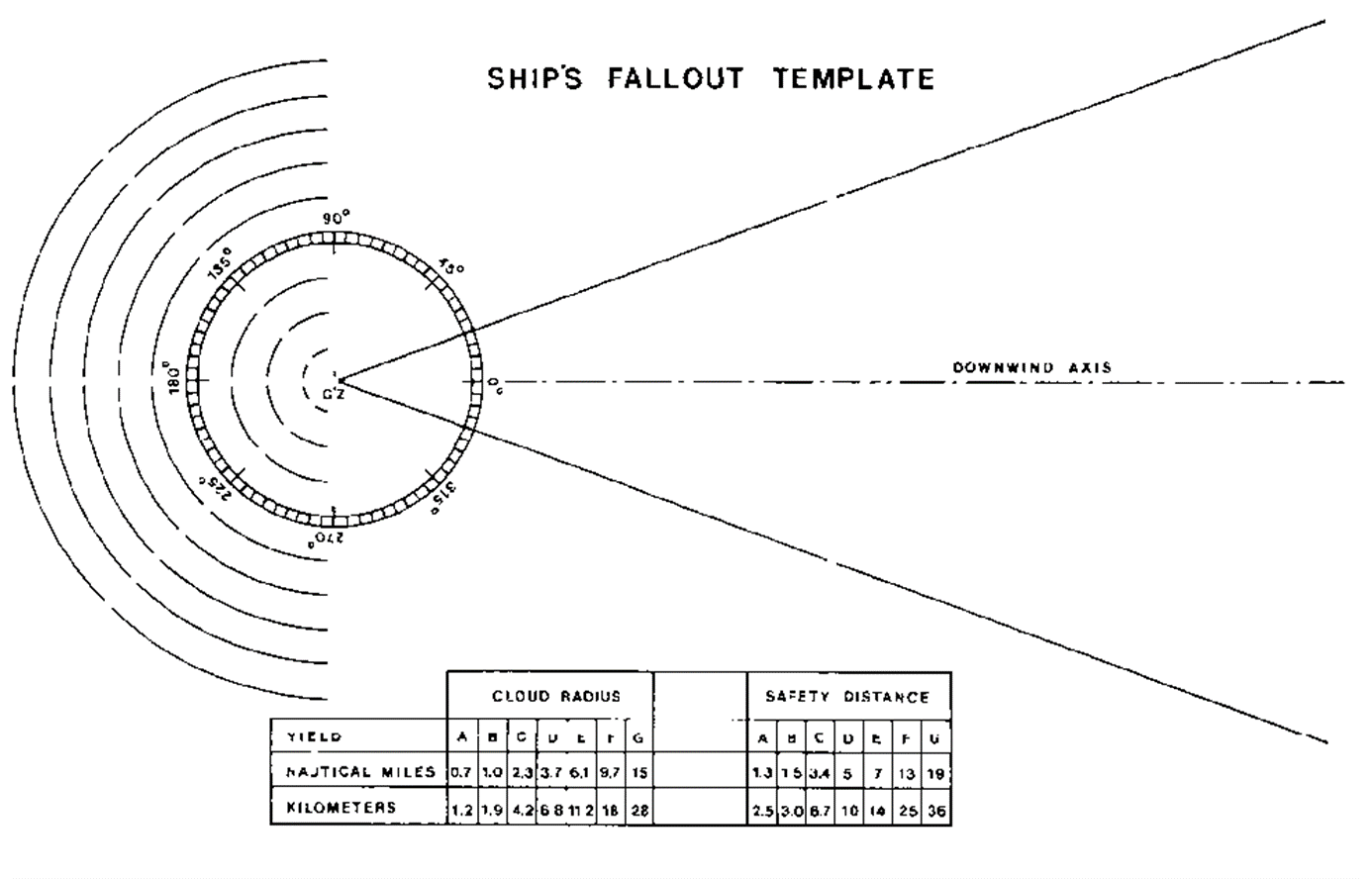
Figure G40-I, Ship’s Fallout Template.
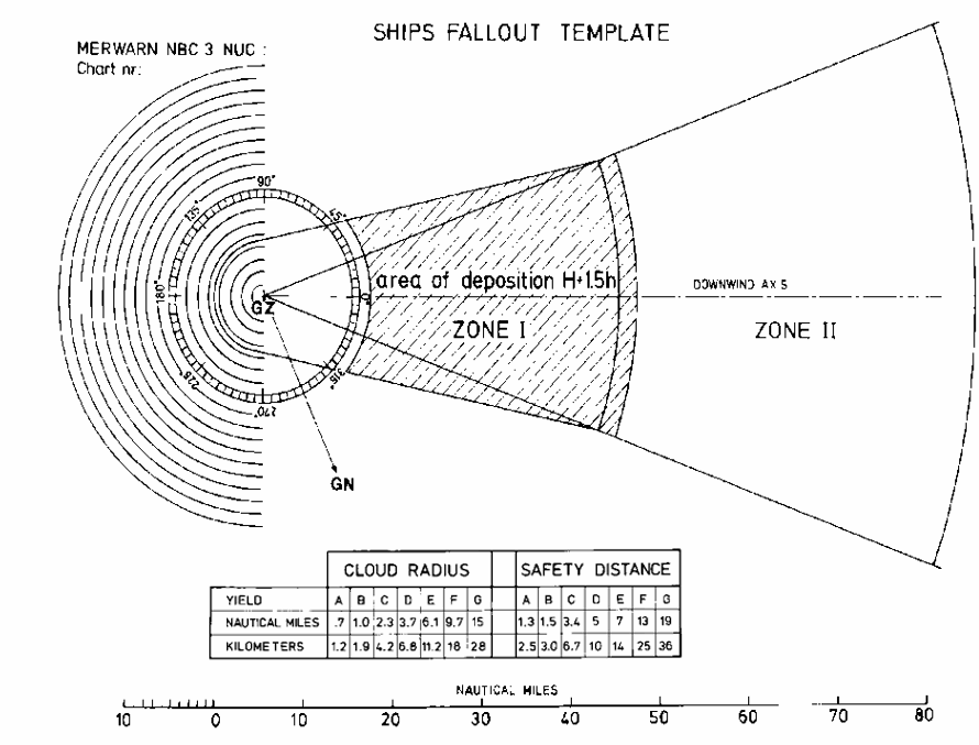
Figure 40-II, Fallout Plotting, using Ship’s Template.
APPENDIX "B"
Instructions to Masters in an EMERGENCY on defence against Nuclear fall-out
1Attacks with nuclear weapons may be expected on land targets adjacent to your route. Such attacks are likely to result in radioactive fall-out being deposited over large sea areas, through which you may have to pass. It may be possible to issue a general warning to indicate which areas are likely to be dangerous at any particular time.
2As fall-out will probably be in the form of fine dust, which may well be invisible, you should observe the following precautions during nuclear fall-out.
3If your ship is equipped with the necessary instruments to detect fall-out, these precautions may be relaxed accordingly.
Precautions to be taken
4If your ship has a pre-arranged radioactive counter-measure plan prepared, ensure that all the measures laid down in that plan are carried out. If no such plan is in existence, improvise measures as indicated below:
(a)Select a group, or groups, of compartments as low
down in the ship and as far removed from the ship's sides as
possible within which the crew can take shelter. These spaces
should be equipped with washing and lavatory facilities, and
sufficient food should be stowed there to last for the passage
through the dangerous area. Spaces selected should be capable
of being completely shut down with all ventilation and other
openings secured.
(b)Strike below, or cover, as much weather deck gear as
possible, particularly absorbent materials such as rope,
awnings, etc. Ensure that food stores and galleys are closed
down with all openings closed. Stop all ventilation fans and
close or cover all ventilation and other openings, which are
not essential for running machinery and continued steaming. In
the absence of suitable closures, the use of canvas covers,
adhesive tape, etc., is recommended.
(c)Rig all available fire-fighting/wash-deck hoses and
nozzles to spray water continuously over as much of the weather
decks and superstructure as possible, to prevent contamination
settling. If complete coverage is impossible, concentrate
effort on the navigating position, over the top of the shelter
position(s) and above the machinery spaces.
(d)If a continued spraying of the upper-works is
impracticable, organize working parties at frequent intervals
to wash down the weather decks and superstructure to reduce the
build-up of contamination.
(e)Reduce the number of your crew who must remain on the
weather decks or in positions near the weather decks, or in
machinery spaces, to the bare minimum required for safe
steaming, and keep the remainder in the selected shelter
position(s).
(f)Ensure that all men who must remain in exposed
positions (including machinery spaces, unless ventilation can
be stopped) are fully clothed, preferably in "foul weather"
clothing, with all the skin covered so far as
practicable.
(g)During your passage, so far as the numbers of
appropriately skilled personnel allow, change round those
manning exposed or relatively unsheltered positions (including
the machinery spaces) as often as possible, in order to spread
the radiation dosage. Remember that this advice also applies to
YOU; take as much shelter as the safe navigation of your ship
will permit.
(h)Ensure that all men who have been exposed remove at
least their outer clothing on returning to shelter, wash
thoroughly their exposed skin, especially the hands, face and
neck, as soon as possible, and in any case before drinking or
eating.
(i)Restrict unnecessary movement throughout the ship, to
minimize the possible spread of contamination.
(j)Unless essential, do not distil water for drinking
while in the dangerous areas.
(k)As soon as possible after clearing the dangerous
area, carry out a thorough hosing down of the entire weather
decks and superstructure.
Authority: Department of National Defence (DND)
Report a problem on this page
- Date modified: