
35Firing Practice and Exercise Areas
Explanatory Notes
1Firing and
bombing practices, and defence exercises, take place in a number
of areas off the coasts of Canada.
2The principal
types of practices carried out are:
(a)Bombing
practice from aircraft.
(b)Air
to air, and air to sea or ground firing. The former is carried
out by aircraft at a large white or red sleeve, a winged
target, or flag towed by another aircraft moving on a steady
course. The latter are carried out from aircraft at towed or
stationary targets on sea or land, the firing taking place to
seaward in the case of those on land. All marine craft
operating as range safety craft, target towers or control
launches for radio controlled targets will display, for
identification purposes, while in or in the vicinity of the
danger area, the following markings:
(i)A
large red flag at the masthead;
(ii)A
painted canvas strip, 1.8 m (6 ft.) by .9 m
(3 ft.) with red and white chequers in .3 m
(1 ft.) squares, on the fore deck or cabin roof.
(c)Anti-aircraft firing.
This may be from guns, missiles or machine guns at a target towed by aircraft as in (b) above, a pilotless target aircraft, or at balloons or kites. Practice may take place from shore batteries or ships. Warning signals as a rule are shown from shore batteries; ships fly a red flag.
(d)Firing
from shore batteries or ships at sea at fixed or floating
targets. Warning signals usually shown as in (c).
(e)Firing
at remote-controlled craft.
These craft are approximately 20.7 m (68 ft.) in length and carry not under command shapes and lights, as well as normal navigation lights. Exercises consisting of surface firing by ships, practice bombing, air to sea firing and rocket firing will be carried out against these craft or targets towed by them. A control craft will keep visual and radar watch up to approximately 8 nautical miles and there will be cover from the air over a much greater range to ensure that other shipping will not be endangered.
3Warning
signals, when given, usually consist of red flags by day and red
fixed or red flashing lights at night. The absence of any such
signal cannot, however, be accepted as evidence that a practice
area does not exist. Warning signals are shown from shortly
before practice commences until it ceases. Ships and aircraft
carrying out night exercises may illuminate with bright red or
orange flares.
4CAUTION. A
vessel may be aware of the existence of a practice area from
Local Notices to Mariners or similar method of promulgation and
by observing the warning signals of the practice. The Range
Authorities are responsible for ensuring that there should be
no risk of damage from falling shell-splinters, bullets, etc.,
to any vessel which may be in a practice area.
Except where stated under Employment, areas are only in use intermittently or over limited periods, and when it is intended that a firing practice and exercise area be used, this information will be promulgated by local Canadian Coast Guard Marine Radio Broadcasts and may also be advertised in local newspapers. Maritime Command vessels are informed by Navigational Warning Messages CANHYDROLANT or CANHYDROPAC.
5 (a)The DND Sea area alphabetical identification designators in this Notice are used for marine purposes and are quoted in marine warning messages advertising the reservation of sea space for armed forces exercises. They are also shown in areas displayed on marine charts, however, not all areas are so displayed. Designators for marine areas on the West Coast are prefixed W; those for areas in the Great Lakes are prefixed L; those for the East Coast are not prefixed.
(b)Area descriptions
All bearings are true and those relating to arcs are from seaward. Miles are in nautical miles. Unless otherwise specified coordinates are based on North American Datum 1983 (NAD 83) which is equivalent to WGS 84.
(c)Employment abbreviations
The following abbreviations are used to indicate the employment of DND Exercise Areas:
|
A/A |
Anti-Aircraft Firing |
|
Missile |
Surface to Air Missile Firing |
|
S |
Surface Firing |
|
S.ht |
Surface Firing High Trajectory |
|
T |
Torpedo Firing |
|
NF |
Non-Firing area for general purpose type exercise |
|
A to A |
Air to Air Firing |
|
A to S |
Air to Sea Firing |
|
B |
Bombing |
|
R |
Rocket Firing |
|
A |
Non-Firing area for general purpose type air exercises |
|
A/S.he |
Anti-Submarine Exercise including high explosive projectiles |
|
A/S |
Anti-Submarine Exercise excluding high explosive projectiles |
|
SS |
Subsurface Exercises |
6The airspace identification numbers used in this Notice conform to the International Civil Aviation Organization (ICAO) Standards for airspace designations.
The identification system consists of a three-part code as follows:
(a)The
assigned national identification letters - Canada is CY;
and
(b)The
letter R for a restricted area or the letter
D for a danger area; and
(c)A three-digit number which will identify the airspace. This number will also indicate the region of Canada within which the area is located according to the following criteria:
|
101 to 199 |
British Columbia |
|
201 to 299 |
Alberta |
|
301 to 399 |
Saskatchewan |
|
401 to 499 |
Manitoba |
|
501 to 599 |
Ontario |
|
601 to 699 |
Québec |
|
701 to 799 |
New Brunswick; Nova Scotia; Prince Edward Island; Newfoundland |
|
801 to 899 |
Yukon Territory |
|
901 to 999 |
Northwest Territories; Arctic Islands |
EXAMPLE: CYD401
|
CY |
CY indicates Canada, |
|
D |
Indicates Danger Area, |
|
401 |
Indicates the assigned number of the area in Manitoba |
7WARNING
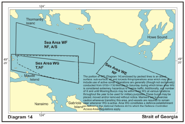
The portion of WG (Diagram 14) enclosed by pecked lines is an active surface, sub-surface, air and torpedo firing/operations area which may also include use of active sonar. Operations are generally (though not exclusively) conducted from 0700-1730 Monday to Saturday during which times area WG is considered extremely hazardous to marine traffic. Additionally, any number of lit and unlit Mooring Buoys may be within Area WG at various locations throughout the year to be used for military purposes. These buoys may be placed, moved and/or removed without notice. Mariners are to exercise caution whenever transiting this area, and vessels are required to remain clear whenever WG is active. Area WG constitutes a defence establishment as defined in the National Defence Act to which the Defence Controlled Access Area Regulations apply.
EAST COAST
|
|
|||||
|
Sea Areas |
Air Space |
Location |
Coordinates |
Employment |
Diagram |
|
*ALPHA |
|
Charts |
44°42′N 63°00′W |
Sub surface operations area. |
1 |
|
Chart |
44°42′N 63°00′W |
||||
|
BRAVO |
|
Charts |
44°28′N 63°40′W |
Sub surface operations area. |
1 |
|
CHARLIE |
|
Charts |
44°28′N 64°05′W |
Sub surface operations area. |
|
|
Chart |
44°28′N 64°05′W |
||||
|
CHARLIE |
|
Charts |
44°00′N 64°40′W |
Sub surface operations area. |
1 |
|
Chart |
44°00′N 64°00′W |
||||
|
Chart |
43°30.0′N 65°24.5′W |
||||
|
CHARLIE |
|
Charts |
43°30′N 65°00′W |
Sub surface operations area. |
1 |
|
DELTA |
To |
Charts |
44°19′N 64°00′W |
Sub surface operations area. |
1 |
|
DELTA |
To |
Charts |
44°19′N 63°45′W |
Sub surface operations area. |
1 |
|
Charts |
44°19′N 63°40′W |
||||
|
DELTA |
To |
Charts |
44°10′N 63°45′W |
Sub surface operations area. |
1 |
|
Charts |
44°10′N 63°40′W |
||||
|
DELTA |
To |
Charts |
44°10′N 64°00′W |
Sub surface operations area. |
1 |
|
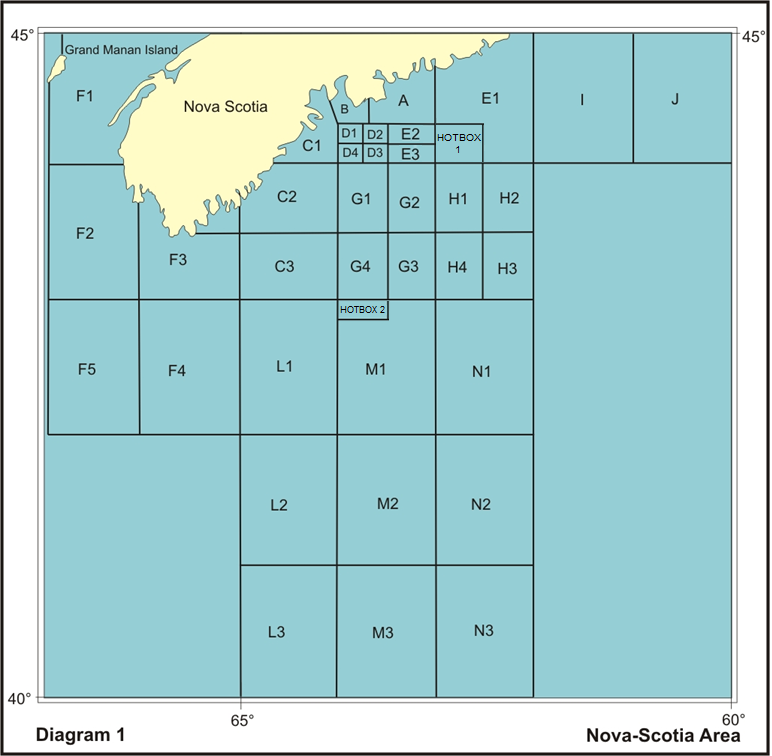
ECHO |
|
Charts |
44°59′N 62°00′W |
Sub surface operations area. |
1 |
|
Chart |
44°42′N 63°00′W |
||||
|
Chart |
44°42′N 63°00′W |
||||
|
Chart |
44°42′N 63°00′W |
||||
|
HOTBOX |
To |
Charts |
44°00’N 063°00’W |
Sub surface operations area. |
1 |
|
ECHO |
To |
Charts |
44°19′N 063°30′W |
Sub surface operations area. |
1 |
|
ECHO |
To |
Charts |
44°10’N 063°30’W |
Sub surface operations area. |
1 |
|
FOXTROT |
|
Charts |
45°03′N 66°46′W |
Sub surface operations area. |
1 |
|
Chart |
Southern limit at |
||||
|
|
|
Charts |
43°43′N 66°00′W |
Sub surface operations area. |
1 |
|
Chart |
44°00′N 66°40′W |
||||
|
Chart |
43°33′N 66°00′W |
||||
|
FOXTROT |
|
Charts |
43°30′N 65°24′W |
Sub surface operations area. |
1 |
|
Chart |
43°00′N 65°30′W |
||||
|
|
Chart |
43°33.0′N 66°00.0′W |
|
|
|
|
FOXTROT |
|
Charts |
43°00′N 66°00′W |
Sub surface operations area. |
1 |
|
Chart |
43°00′N 66°00′W |
||||
|
Chart |
43°00′N 66°00′W |
||||
|
FOXTROT |
|
Charts |
43°00′N 66°54′W |
Sub surface operations area. |
1 |
|
Chart |
43°00′N 66°54′W |
||||
|
Chart |
43°00′N 66°40′W |
||||
|
Chart |
43°00′N 66°36′W |
||||
|
GOLF |
To |
Charts |
44°00′N 64°00′W |
Sub surface operations area. |
1 |
|
Charts |
44°00′N 63°40′W |
||||
|
Chart |
44°00′N 64°00′W |
||||
|
Chart |
43°33′N 64°00′W |
||||
|
GOLF |
To |
Charts |
44°00′N 63°30′W |
Sub surface operations area. |
1 |
|
Chart |
44°00′N 63°30′W |
||||
|
Chart |
44°00′N 63°30′W |
||||
|
Chart |
43°33′N 63°30′W |
||||
|
GOLF |
To |
Charts |
43°30′N 63°30′W |
Sub surface operations area. |
1 |
|
GOLF |
To |
Charts |
43°30′N 64°00′W |
Sub surface operations area. |
1 |
|
Chart |
43°30′N 63°40′W |
||||
|
HOTEL |
To |
Charts |
44°00′N 63°00′W |
Sub surface operations area. |
1 |
|
Chart |
44°00′N 63°00′W |
||||
|
Chart |
44°00′N 63°00′W |
||||
|
Chart |
44°00′N 63°00′W |
||||
|
Chart |
43°33′N 63°00′W |
||||
|
HOTEL |
To |
Charts |
44°00′N 62°30′W |
Sub surface operations area. |
1 |
|
Chart |
44°00′N 62°30′W |
||||
|
HOTEL |
To |
Charts |
43°30′N 62°30′W |
Sub surface operations area. |
1 |
|
HOTEL |
To |
Charts |
43°30′N 63°00′W |
Sub surface operations area. |
1 |
|
Chart |
43°30′N 63°00′W |
||||
|
Chart |
43°00′N 62°34′W |
||||
|
INDIA |
|
Charts |
45°16′N 61°00′W |
Sub surface operations area. |
1 |
|
Chart |
44°52′N 62°00′W |
||||
|
JULIET |
|
Charts |
45°53′N 60°00′W |
Sub surface operations area. |
1 |
|
Chart |
44°52′N 61°00′W |
||||
|
LIMA |
|
Charts |
43°00′N 65°00′W |
Sub surface operations area. |
1 |
|
Chart |
43°00′N 65°00′W |
||||
|
LIMA |
|
Charts |
42°00′N 65°00′W |
Sub surface operations area. |
1 |
|
Chart |
41°24′N 65°00′W |
||||
|
LIMA |
|
Charts |
41°00′N 65°00′W |
Sub surface operations area. |
1 |
|
MIKE |
|
Charts |
43°00′N 64°00′W |
Sub surface operations area. |
1 |
|
Chart |
43°00′N 64°00′W |
||||
|
Chart |
43°00′N 63°40′W |
||||
|
HOTBOX |
To |
Chart |
42°50’N 064°00’W |
Sub surface operations area. |
1 |
|
MIKE |
|
Charts |
42°00′N 64°00′W |
Sub surface operations area. |
1 |
|
Chart |
41°24′N 64°00′W |
||||
|
MIKE |
|
Charts |
41°00′N 64°00′W |
Sub surface operations area. |
1 |
|
NOVEMBER |
|
Charts |
43°00′N 63°00′W |
Sub surface operations area. |
1 |
|
Chart |
43°00′N 63°00′W |
||||
|
Chart |
42°00′N 62°34′W |
||||
|
Chart |
42°44′N 63°00′W |
||||
|
NOVEMBER |
|
Charts |
42°00′N 63°00′W |
Sub surface operations area. |
1 |
|
Chart |
41°24′N 63°00′W |
||||
|
NOVEMBER |
|
Charts |
41°00′N 63°00′W |
Sub surface operations area. |
1 |
|
Gulf of St. Lawrence Area |
|||||
|
|
Airspace |
Location |
Coordinates |
Employment |
Diagram |
|
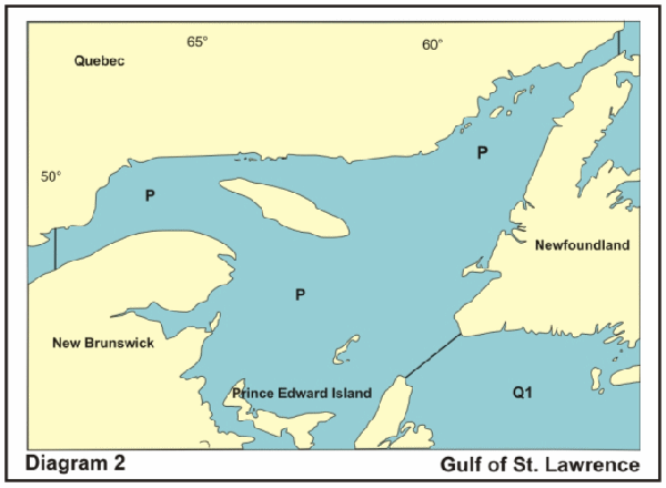
PAPA |
|
Chart |
Gulf of St Lawrence |
Sub surface operations area. |
2 |
|
QUÉBEC |
|
Chart |
46°56′N 55°30′W |
Sub surface operations area. |
2 & 3 |
|
Chart |
45°53′N 60°00′W |
||||
|
Chart |
45°53′N 60°00′W |
||||
|
QUÉBEC |
|
Chart |
45°17′N 60°00′W |
Sub surface operations area. |
3 |
|
Chart |
45°17′N 60°00′W |
||||
|
Chart |
45°17′N 60°00′W |
||||
|
Chart |
44°52.0′N 60°00.0′W |
||||
|
QUÉBEC |
|
Chart |
44°45′N 60°00′W |
Sub surface operations area. |
3 |
|
Chart |
44°45′N 60°00′W |
||||
|
Chart |
44°45′N 60°00′W |
||||
|
Chart |
44°00.0′N 59°45.0′W |
||||
|
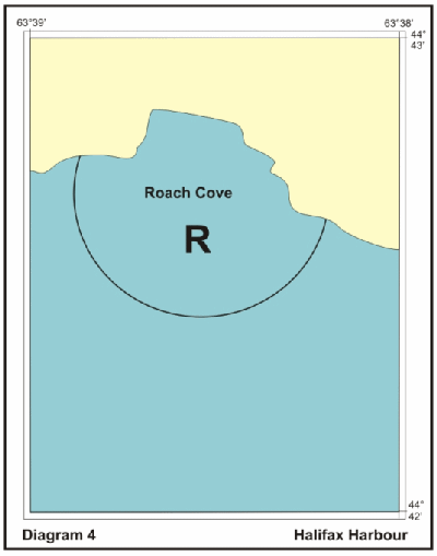
ROMEO |
|
Chart |
An arc from shoreline to shoreline centred on 44°42′43″N 63°38′40″W with radius of 365 metres |
Underwater demolition training |
4 |
|
SIERRA |
|
Chart |
48°40′N 53°05′W |
Sub surface operations area. |
3 |
|
SIERRA |
|
Chart |
46°00′N 55°30′W |
Sub surface operations area. |
3 |
|
SIERRA |
|
Chart |
45°20′N 55°30′W |
Sub surface operations area. |
3 |
|
Alexandra Point (PEI) & Georgian Bay Firing Area |
|||||
|
Designators |
Location |
Coordinates |
Employment |
Diagram |
|
|
DND |
DOT |
||||
|
|
|
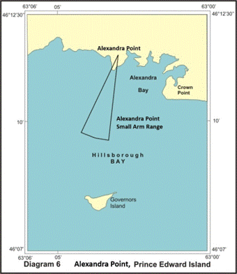
Alexandra Point, Prince Edward Island, |
From Alexandra Point (46°11′25"N 63°02′58″W) extending 1.9 nautical mile limited by an arc of 029°, from 184° to 213°. |
|
6 |
|
|
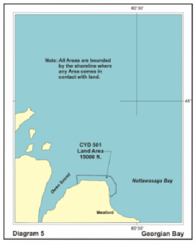
CYD501 |
CYD501 |
44°42′48"N 80°46′11″W |
1S |
5 |
|
|
|
|
Lake Ontario & Erie Area Firing Area |
|||||
|
Designators |
Location |
Coordinates |
Employment |
Diagram |
|
|
DND |
DOT |
||||
|
|
|
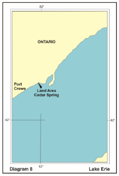
Erie Lake (Cedar Springs, Ontario) |
Offshore, from |
|
8 |
|
|
|
Ontario Lake, Grimsby, |
43°13′21"N 79°36′59″W |
|
7 |
|
|
|
Ontario Lake, Niagara-on-the-Lake |
43°15′31"N 79°06′13″W |
|
8 |
|
DND Inspection Services - Lake St. Pierre (Québec) Area |
|||||
|
Designators |
Location |
Coordinates |
Employment |
Diagram |
|
|
DND |
DOT |
||||
|
|
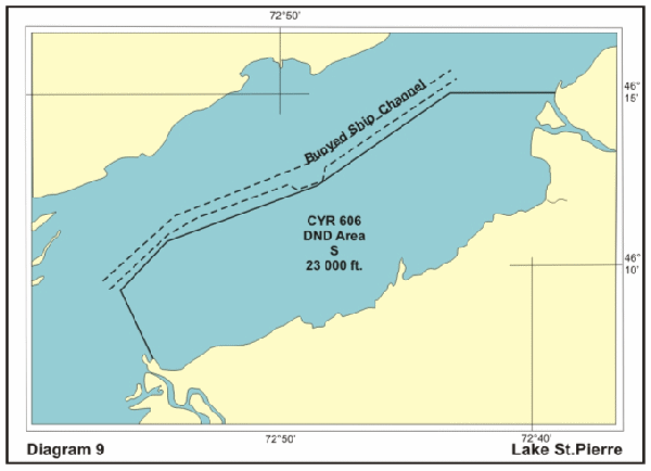
CYR606 |
Lac St. Pierre, Quebec |
Marine portion bounded by south shore of |
1In
continuous use |
9 |
|
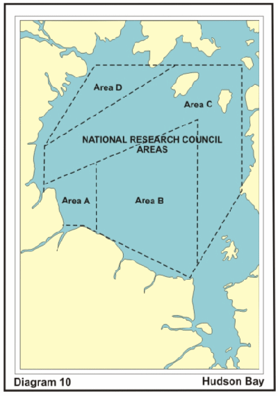
National Research Council Areas - Hudson Bay |
|||||
|
Rocket Area |
Location |
Coordinates |
Employment |
Diagram |
|
|
DND |
DOT |
||||
|
|
|
Hudson Bay and Strait Churchill, Manitoba |
AREA A
58°56′00″N 94°00′00″W AREA B
59°46′30″N 90°00′′00″W AREA C
55°28′00″N 82°00′00″W
AREA D |
1R Information about a launch will be published through a Navigational Warning issued by Iqaluit MCTS. Further details can be obtained by
Telephone: |
10 |
Authority: Department of National Defence (NDHQ)
|
West Coast Area |
||||||
|
Sea Area |
Airspace |
Location |
Coordinates |
Employment |
Diagram |
|
|
CHARLIE |
|
Chart |
51°30′00″N 129°20′00″W |
Sub surface operations area. |
11 |
|
|
CHARLIE |
|
Chart |
51°30′00″N 129°00′00″W |
Sub surface operations area. |
11 |
|
|
CHARLIE |
|
Chart |
51°30′00″N 128°40′00″W |
Sub surface operations area. |
11 |
|
|
CHARLIE |
|
Chart |
51°30′00″N 128°20′00″W |
Sub surface operations area. |
11 |
|
|
CHARLIE |
|
Chart |
51°30′00″N 128°00′00″W |
Sub surface operations area. |
11 |
|
|
Areas CHARLIE ALPHA 6 to CHARLIE ALPHA 14 inclusive not allocated |
||||||
|
CHARLIE |
|
Chart |
51°15′00″N 129°20′00″W |
Sub surface operations area. |
11 |
|
|
CHARLIE |
|
Chart |
51°15′00″N 129°00′00″W |
Sub surface operations area. |
11 |
|
|
CHARLIE |
|
Chart |
51°15′00″N 128°40′00″W |
Sub surface operations area. |
11 |
|
|
CHARLIE |
|
Chart |
51°15′00″N 128°20′00″W |
Sub surface operations area. |
11 |
|
|
CHARLIE |
|
Chart |
51°15′00″N 128°00′00″W |
Sub surface operations area. |
11 |
|
|
Areas CHARLIE BRAVO 6 to CHARLIE BRAVO 14 inclusive not allocated |
||||||
|
CHARLIE |
|
Chart |
51°00′00″N 129°20′00″W |
Sub surface operations area. |
11 |
|
|
CHARLIE |
|
Chart |
51°00′00″N 129°00′00″W |
Sub surface operations area. |
11 |
|
|
CHARLIE |
|
Chart |
51°00′00″N 128°40′00″W |
Sub surface operations area. |
11 |
|
|
CHARLIE |
|
Chart |
51°00′00″N 128°20′00″W |
Sub surface operations area. |
11 |
|
|
CHARLIE |
|
Chart |
51°00′00″N 128°00′00″W |
Sub surface operations area. |
11 |
|
|
Areas CHARLIE CHARLIE 6 to CHARLIE CHARLIE 14 inclusive not allocated |
||||||
|
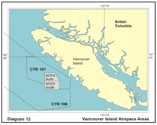
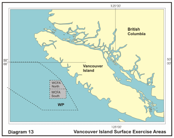
CHARLIE DELTA 1 |
CYR 106 to |
Chart |
50°45′00″N 129°20′00″W |
Sub surface operations area. |
11 & 12 |
|
|
CHARLIE DELTA 2 |
|
Chart |
50°45′00″N 129°00′00″W |
Sub surface operations area. |
11 |
|
|
CHARLIE DELTA 3 |
|
Chart |
50°45′00″N 128°40′00″W |
Sub surface operations area. |
11 |
|
|
CHARLIE DELTA 4 |
|
Chart |
50°45′00″N 128°20′00″W |
Sub surface operations area. |
11 |
|
|
CHARLIE DELTA 5 |
|
Chart |
50°45′00″N 128°00′00″W |
Sub surface operations area. |
11 |
|
|
CHARLIE DELTA 6 |
|
Chart |
50°45′00″N 127°40′00″W |
Sub surface operations area. |
11 |
|
|
|
||||||
|
CHARLIE |
CYR 106 to |
Chart |
50°30′00″N 129°20′00″W |
Sub surface operations area. |
11 & 12 |
|
|
CHARLIE |
CYR 106 to |
Chart |
50°30′00″N 129°00′00″W |
Sub surface operations area. |
11 & 12 |
|
|
CHARLIE |
|
Chart |
50°30′00″N 128°40′00″W |
Sub surface operations area. |
11 |
|
|
CHARLIE |
|
Chart |
50°30′00″N 128°20′00″W |
Sub surface operations area. |
11 |
|
|
CHARLIE |
|
Chart |
50°30′00″N 128°00′00″W |
Sub surface operations area. |
11 |
|
|
CHARLIE |
|
Chart |
50°30′00″N 127°40′00″W |
Sub surface operations area. |
11 |
|
|
Areas CHARLIE ECHO 7 to CHARLIE ECHO 14 inclusive not allocated |
||||||
|
CHARLIE |
CYR 106 to |
Chart |
50°15′00″N 129°20′00″W |
Sub surface operations area. |
11 |
|
|
CHARLIE |
CYR 106 to |
Chart |
50°15′00″N 129°00′00″W |
Sub surface operations area. |
11 |
|
|
CHARLIE |
CYR 106 to |
Chart |
50°15′00″N 128°40′00″W |
Sub surface operations area. |
11 & 12 |
|
|
CHARLIE |
CYR 106 to |
Chart |
50°15′00″N 128°20′00″W |
Sub surface operations area. |
11 |
|
|
CHARLIE |
|
Chart |
50°15′00″N 128°00′00″W |
Sub surface operations area. |
11 |
|
|
CHARLIE |
|
Chart |
50°15′00″N 127°40′00″W |
Sub surface operations area. |
11 |
|
|
CHARLIE |
|
Chart |
50°15′00″N 127°20′00″W |
Sub surface operations area. |
11 |
|
|
Areas CHARLIE FOXTROT 8 to CHARLIE FOXTROT 14 inclusive not allocated |
||||||
|
CHARLIE |
CYR 106 to |
Chart |
50°00′00″N 129°20′00″W |
Sub surface operations area. |
11 & 12 |
|
|
CHARLIE |
CYR 106 to |
Chart |
50°00′00″N 129°00′00″W |
Sub surface operations area. |
11 & 12 |
|
|
CHARLIE |
CYR 106 to |
Chart |
50°00′00″N 128°40′00″W |
Sub surface operations area. |
11 & 12 |
|
|
CHARLIE |
CYR 106 to |
Chart |
50°00′00″N 128°20′00″W |
Sub surface operations area. |
11 & 12 |
|
|
CHARLIE |
CYR 106 to |
Chart |
50°00′00″N 128°00′00″W |
Sub surface operations area. |
11 & 12 |
|
|
CHARLIE |
CYR 106 to |
Chart |
50°00′00″N 127°40′00″W |
Sub surface operations area. |
11 |
|
|
CHARLIE |
|
Chart |
50°00′00″N 127°20′00″W |
Sub surface operations area. |
11 |
|
|
CHARLIE |
|
Chart |
50°00′00″N 127°00′00″W |
Sub surface operations area. |
11 |
|
|
CHARLIE |
|
Chart |
50°00′00″N 126°40′00″W |
Sub surface operations area. |
11 |
|
|
♣ = Only that portion of the area that is within Area WP (Defined at Diagram 11) |
||||||
|
Areas CHARLIE GOLF 10 to CHARLIE GOLF 14 inclusive not allocated |
||||||
|
CHARLIE |
CYR 106 to 23,000 feet |
Chart |
49°45′00″N 129°20′00″W |
Sub surface operations area. |
11 |
|
|
CHARLIE |
CYR 106 to 23,000 feet |
Chart |
49°45′00″N 129°00′00″W |
Sub surface operations area. |
11 & 12 |
|
|
CHARLIE |
CYR 106 to 23,000 feet |
Chart |
49°45′00″N 128°40′00″W |
Sub surface operations area. |
11 & 12 |
|
|
CHARLIE |
CYR 106 to 23,000 feet |
Chart |
49°45′00″N 128°20′00″W |
Sub surface operations area. |
11 & 12 |
|
|
CHARLIE |
CYR 106 to 23,000 feet |
Chart |
49°45′00″N 128°00′00″W |
Sub surface operations area. |
11 & 12 |
|
|
CHARLIE |
CYR 106 to 23,000 feet |
Chart |
49°45′00″N 127°40′00″W |
Sub surface operations area. |
11 & 12 |
|
|
CHARLIE |
CYR 106 to 23,000 feet |
Chart |
49°45′00″N 127°20′00″W |
Sub surface operations area. |
11 & 12 |
|
|
CHARLIE |
CYR 106 to 23,000 feet |
Chart |
49°45′00″N 127°00′00″W |
Sub surface operations area. |
11 |
|
|
CHARLIE |
|
Chart |
49°45′00″N 126°40′00″W |
Sub surface operations area. |
11 |
|
|
CHARLIE |
|
Chart |
49°45′00″N 126°20′00″W |
Sub surface operations area. |
11 |
|
|
♣ = Only that portion of the area that is within Area WP (Defined at Diagram 11) |
||||||
|
Areas CHARLIE HOTEL 11 to CHARLIE HOTEL 14 inclusive not allocated |
||||||
|
CHARLIE |
CYR 106 to 23,000 feet |
Chart |
49°30′00″N 129°20′00″W |
Sub surface operations area. |
11 |
|
|
CHARLIE |
CYR 106 to 23,000 feet |
Chart |
49°30′00″N 129°00′00″W |
Sub surface operations area. |
11 &12 |
|
|
CHARLIE |
CYR 106 to 23,000 feet |
Chart |
49°30′00″N 128°40′00″W |
Sub surface operations area. |
11 & 12 |
|
|
CHARLIE |
CYR 106 to 23,000 feet |
Chart |
49°30′00″N 128°20′00″W |
Sub surface operations area. |
11 & 12 |
|
|
CHARLIE |
CYR 106 to 23,000 feet |
Chart |
49°30′00″N 128°00′00″W |
Sub surface operations area. |
11 & 12 |
|
|
CHARLIE |
CYR 106 to 23,000 feet |
Chart |
49°30′00″N 127°40′00″W |
Sub surface operations area. |
11 & 12 |
|
|
CHARLIE |
CYR 106 to 23,000 feet |
Chart |
49°30′00″N 127°20′00″W |
Sub surface operations area. |
11 & 12 |
|
|
CHARLIE |
CYR 106 to 23,000 feet |
Chart |
49°30′00″N 127°00′00″W |
Sub surface operations area. |
11 |
|
|
CHARLIE |
CYR 106 to 23,000 feet |
Chart |
49°30′00″N 126°40′00″W |
Sub surface operations area. |
11 |
|
|
CHARLIE |
|
Chart |
49°30′00″N 126°20′00″W |
Sub surface operations area. |
11 |
|
|
CHARLIE INDIA 11 |
|
Chart |
49°30′00″N 126°00′00″W |
Sub surface operations area. |
11 |
|
|
♣ = Only that portion of the area that is within Area WP (Defined at Diagram 11) |
||||||
|
Areas CHARLIE INDIA 12 to CHARLIE INDIA 14 inclusive not allocated |
||||||
|
CHARLIE JULIET 1 |
CYR 106 to 23,000 feet |
Chart |
49°15′00″N 129°20′00″W |
Sub surface operations area. |
11 |
|
|
CHARLIE JULIET 2 |
CYR 106 to 23,000 feet |
Chart |
49°15′00″N 129°00′00″W |
Sub surface operations area. |
11 & 12 |
|
|
CHARLIE JULIET 3 |
CYR 106 to 23,000 feet |
Chart |
49°15′00″N 128°40′00″W |
Sub surface operations area. |
11 & 12 |
|
|
CHARLIE JULIET 4 |
CYR 106 to 23,000 feet |
Chart |
49°15′00″N 128°20′00″W |
Sub surface operations area. |
11 & 12 |
|
|
CHARLIE JULIET 5 |
CYR 106 to 23,000 feet |
Chart |
49°15′00″N 128°00′00″W |
Sub surface operations area. |
11 & 12 |
|
|
CHARLIE JULIET 6 |
CYR 106 to 23,000 feet |
Chart |
49°15′00″N 127°40′00″W |
Sub surface operations area. |
11 & 12 |
|
|
CHARLIE JULIET 7 |
CYR 106 to 23,000 feet |
Chart |
49°15′00″N 127°20′00″W |
Sub surface operations area. |
11 & 12 |
|
|
CHARLIE JULIET 8 |
CYR 106 to 23,000 feet |
Chart |
49°15′00″N 127°00′00″W |
Sub surface operations area. |
11 & 12 |
|
|
CHARLIE JULIET 9 |
CYR 106 to 23,000 feet |
Chart |
49°15′00″N 126°40′00″W |
Sub surface operations area. |
11 |
|
|
CHARLIE JULIET 10 |
|
Chart |
49°15′00″N 126°20′00″W |
Sub surface operations area. |
11 |
|
|
CHARLIE JULIET 11 |
|
Chart |
49°15′00″N 126°00′00″W |
Sub surface operations area. |
11 |
|
|
CHARLIE JULIET 12 |
|
Chart |
49°15′00″N 125°40′00″W |
Sub surface operations area. |
11 |
|
|
CHARLIE JULIET 13 |
|
Chart |
49°15′00″N 125°20′00″W |
Sub surface operations area. |
11 |
|
|
♣ = Only that portion of the area that is within Area WP (Defined at Diagram 11) |
||||||
|
Area CHARLIE JULIET 14 not allocated |
||||||
|
CHARLIE KILO 1 |
CYR 106 to 23,000 feet |
Chart |
49°00′00″N 129°20′00″W |
Sub surface operations area. |
11 |
|
|
CHARLIE KILO 2 |
CYR 106 to 23,000 feet |
Chart |
49°00′00″N 129°00′00″W |
Sub surface operations area. |
11 |
|
|
CHARLIE KILO 3 |
CYR 106 to 23,000 feet |
Chart |
49°00′00″N 128°40′00″W |
Sub surface operations area. |
11 & 12 |
|
|
CHARLIE KILO 4 |
CYR 106 to 23,000 feet |
Chart |
49°00′00″N 128°20′00″W |
Sub surface operations area. |
11 & 12 |
|
|
CHARLIE KILO 5 |
CYR 106 to 23,000 feet |
Chart |
49°00′00″N 128°00′00″W |
Sub surface operations area. |
11 & 12 |
|
|
CHARLIE KILO 6 |
CYR 106 to 23,000 feet |
Chart |
49°00′00″N 127°40′00″W |
Sub surface operations area. |
11 & 12 |
|
|
CHARLIE KILO 7 |
CYR 106 to 23,000 feet |
Chart |
49°00′00″N 127°20′00″W |
Sub surface operations area. |
11 & 12 |
|
|
CHARLIE KILO 8 |
CYR 106 to 23,000 feet |
Chart |
49°00′00″N 127°00′00″W |
Sub surface operations area. |
11 & 12 |
|
|
CHARLIE KILO 9 |
CYR 106 to 23,000 feet |
Chart |
49°00′00″N 126°40′00″W |
Sub surface operations area. |
11 |
|
|
CHARLIE KILO 10 |
|
Chart |
49°00′00″N 126°20′00″W |
Sub surface operations area. |
11 |
|
|
CHARLIE KILO 11 |
|
Chart |
49°00′00″N 126°00′00″W |
Sub surface operations area. |
11 |
|
|
CHARLIE KILO 12 |
|
Chart |
49°00′00″N 125°40′00″W |
Sub surface operations area. |
11 |
|
|
CHARLIE KILO 13 |
|
Chart |
49°00′00″N 125°20′00″W |
Sub surface operations area. |
11 |
|
|
♣ = Only that portion of the area that is within Area WP (Defined at Diagram 11) |
||||||
|
Area CHARLIE KILO 14 not allocated |
||||||
|
CHARLIE LIMA 1 |
|
Chart |
48°45′00″N 129°20′00″W |
Sub surface operations area. |
11 |
|
|
CHARLIE LIMA 2 |
CYR 106 to 23,000 feet |
Chart |
48°45′00″N 129°00′00″W |
Sub surface operations area. |
11 |
|
|
CHARLIE LIMA 3 |
CYR 106 to 23,000 feet |
Chart |
48°45′00″N 128°40′00″W |
Sub surface operations area. |
11 |
|
|
CHARLIE LIMA 4 |
CYR 106 to 23,000 feet |
Chart |
48°45′00″N 128°20′00″W |
Sub surface operations area. |
11 & 12 |
|
|
CHARLIE LIMA 5 |
CYR 106 to 23,000 feet |
Chart |
48°45′00″N 128°00′00″W |
Sub surface operations area. |
11 & 12 |
|
|
CHARLIE LIMA 6 |
CYR 106 to 23,000 feet |
Chart |
48°45′00″N 127°40′00″W |
Sub surface operations area. |
11 & 12 |
|
|
CHARLIE LIMA 7 |
CYR 106 to 23,000 feet |
Chart |
48°45′00″N 127°20′00″W |
Sub surface operations area. |
11 & 12 |
|
|
CHARLIE LIMA 8 |
CYR 106 to 23,000 feet |
Chart |
48°45′00″N 127°00′00″W |
Sub surface operations area. |
11 & 12 |
|
|
CHARLIE LIMA 9 |
CYR 106 to 23,000 feet |
Chart |
48°45′00″N 126°40′00″W |
Sub surface operations area. |
11 & 12 |
|
|
CHARLIE LIMA 10 |
|
Chart |
48°45′00″N 126°20′00″W |
Sub surface operations area. |
11 |
|
|
CHARLIE LIMA 11 |
|
Chart |
48°45′00″N 126°00′00″W |
Sub surface operations area. |
11 |
|
|
CHARLIE LIMA 12 |
|
Chart |
48°45′00″N 125°40′00″W |
Sub surface operations area. |
11 |
|
|
CHARLIE LIMA 13 |
|
Chart |
48°45′00″N 125°20′00″W |
Sub surface operations area. |
11 |
|
|
♣ = Only that portion of the area that is within Area WP (Defined at Diagram 11) |
||||||
|
Note:All
Vancouver Island (VI) Areas are bounded by the shoreline
where any area comes in contact |
||||||
|
Strait of Georgia (Area SOG) |
|||||
|
Sea Area |
Airspace |
Location |
Coordinates |
Employment |
Diagram |
|
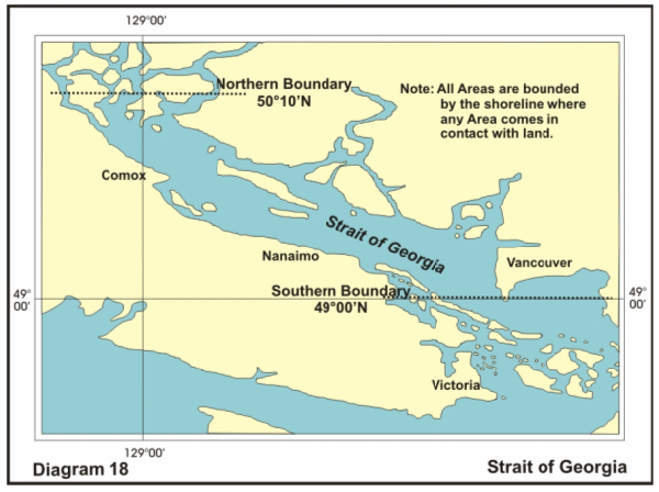
Strait of Georgia |
|
Charts |
Area bounded to the West by Vancouver Island East by
British Columbia mainland North by |
Sub surface operations area. |
18 |
|
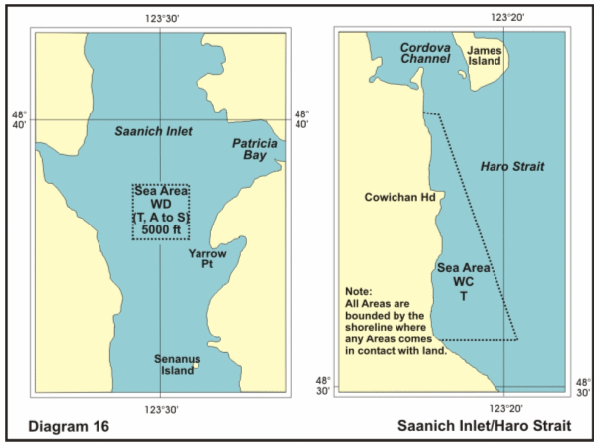
WC |
|
Chart |
48°35′25″N 123°22′18″W |
Firing Exercise (Torpedo) (TORPEX) |
16 |
|
WD |
To |
Chart |
48°38′48″N 123°30′45″W |
Surface and |
16 |
|
WE |
|
Chart |
49°11′00″N 123°24′00″W |
Non-firing exercises. |
14 |
|
WF |
|
Chart |
49°19′18″N 123°43′30″W |
Air, Sub surface and surface operations area. |
14 |
|
WG |
To |
Chart |
49°21′28″N 124°09′30″W |
Air, Sub surface and surface operations area. |
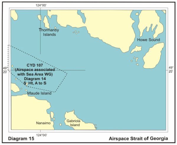
14 & 15 |
|
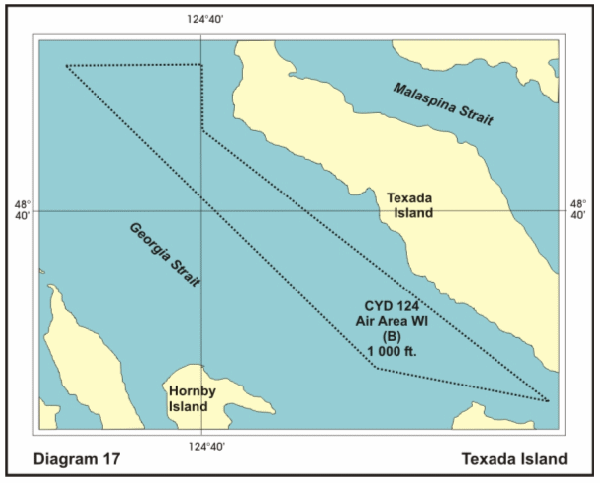
WI |
To |
Chart |
49°46′30″N 124°50′00″W |
Air and Sub surface exercise area. |
17 |
|
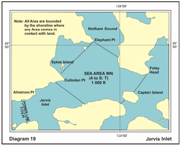
WN |
To |
Chart |
49°50′06″N 124°02′12″W |
Surface and Sub surface general operations area. |
19 |
|
Note: All of SOG Area is bounded by the shoreline where the area comes in contact with land |
|||||
Canadian Forces Maritime Experimental and Test Ranges (CFMETR) - Nanoose Bay, BC
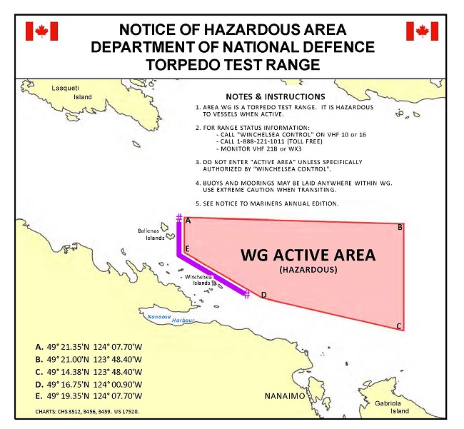
The Canadian Forces Maritime Experimental and Test Ranges
tests ship and aircraft systems and torpedoes launched by surface
vessels, submarines, or aircraft. No explosives are
used; however, a hazard exists due to the possibility of the
torpedo homing on vessels and then the vessel being struck by the
torpedo on its way to the surface.
Testing is usually carried out during daylight hours Monday to
Saturday. During testing, area "WG" is "Active". Any vessel
within the area will be required to clear or stop on demand
from the "Winchelsea Island Control" or any of the range
vessels or range helicopter. The positions of these coordinates
are clearly marked on the diagram above.
A transit area 1,000 yards north of Winchelsea Island and
1,000 yards east of South Ballenas Island is recommended
to enable mariners to transit safely around the active area. It
also facilitates unimpeded access to marina facilities in
Schooner Cove and Nanoose Bay. The active range area is clearly
depicted on CHS charts 3512, 3456 and 3459 by means of
pecked lines.
Additional information on active range hours or for safe
transit through the area may be obtained from:
a.Winchelsea Island Control at 1-888-221-1011 (next day's activity only);
b.CFMETR Range
Officer at 250-468-5002 (long range planning);
c.Winchelsea
Island Control VHF CH 10 or 16 (for safe transit area
information when approaching Area "WG"). or
d.CMB
VHF 21B or Weather 3 (listen only, for active times).
e.Navigational
Warning. Prince Rupert MCTS Centre at 250-627-3070.
NAVWARN.MCTSPrinceRupert@innav.gc.ca
f.Victoria MCTS Centre at 250-363-6333.
Area "WG" constitutes a "Defence Establishment" as defined in the National Defence Act to which the Defence Controlled Access Area Regulations apply. Vessels which do not comply with direction from either Winchelsea control or Range Patrol Vessels may be charged for trespassing.
Range vessels exhibit a flashing red light in addition to the prescribed lights and shapes. These vessels may operate outside of scheduled hours and should not be approached within 3,000 yards because they may be in a three-point moor with mooring lines extending to buoys 1,500 yards away. Additionally, lighted and unlighted mooring buoys are randomly located within the area. Mariners are advised to use caution when transiting this area during non-active range periods to avoid mooring buoys and lines.
|
Esquimalt Harbour Approaches Areas |
||||
|
Sea Area |
Airspace |
Location |
Coordinates |
Employment |
|
BANKS 1 |
|
Charts |
48°24’28” N 123° 18’30” W (INTERSECTION OF LAND) |
Sub surface operations area. |
|
BANKS 2 |
|
Charts |
48°27’00” N 123°17’22” W (INTERSECTION OF LAND) |
Sub surface operations area. |
|
BANKS 3 |
|
Charts |
48°14’30” N 123°18’30” W |
Sub surface operations area. |
|
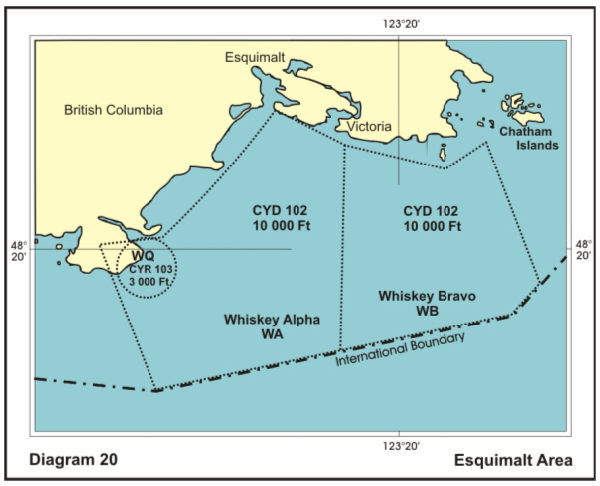
WA |
To |
Chart |
48°20’36” N 123°31’34” W |
General surface and air operations area. |
|
WB |
To |
Chart |
48°24’25” N 123°23’15” W |
General surface and air operations area. |
|
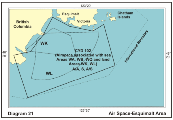
WK |
To |
Chart |
|
General surface and air operations
area. |
|
WL |
To |
Chart |
|
General surface and air operations
area. |
|
WQ |
To |
Chart |
Bentinck Island demolition Range |
Demolition exercise |
|
Note:All
of JDF Strait Area is bounded by the shoreline where the
area comes in contact |
||||
|
Strait of Juan de Fuca (Area SJDF) |
|||||
|
|
Airspace |
Location |
Coordinates |
Employment |
Diagram |
|
Juan De |
|
Chart |
48°27’14” N 124°35’00” W |
Sub surface operations area. |
|
|
Juan De |
|
Chart |
NORTHERN BOUNDARY ALONG A LINE FOLLOWING THE
US/CANADIAN |
Sub surface operations area. |
|
|
Juan De |
|
Chart |
NORTHERN BOUNDARY ALONG A LINE FOLLOWING THE
US/CANADIAN |
Sub surface operations area. |
|
|
Juan De |
|
Chart |
48°06’48” N 123°18’30” W (INTERSECTION OF LAND) |
Sub surface operations area. |
|
|
Juan De |
|
Chart |
COAST OF VANCOUVER ISLAND TO THE NORTH |
Sub surface operations area. |
|
|
Juan De |
|
Chart |
COAST OF VANCOUVER ISLAND TO THE NORTH |
Sub surface operations area. |
|
|
Juan De |
|
Chart |
COAST OF VANCOUVER ISLAND TO THE NORTH |
Sub surface operations area. Surface to Bottom. |
|
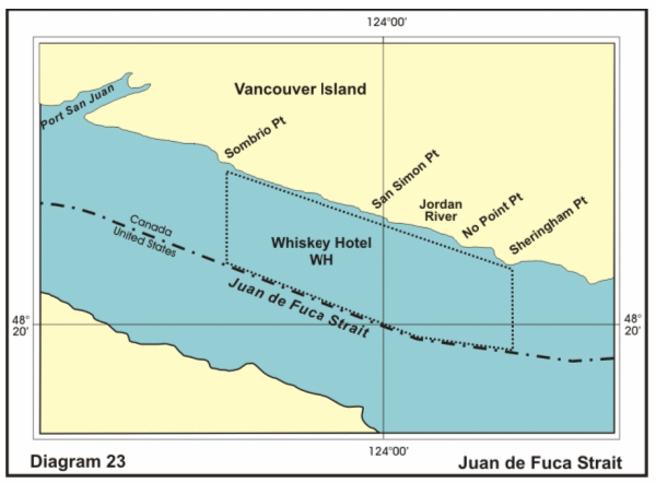
|
WH |
To |
Chart |
48°22’00” N 123°55’05” W |
Firing Exercise (Surface) (FIREX) |
|
|
Note: All of JDF Area is bounded by the shoreline where the area comes in contact with land. |
|||||
|
Queen Charlotte Island (QCI) Areas |
|||||
|
Sea Area |
Airspace |
Location |
Coordinates |
Employment |
Diagram |
|
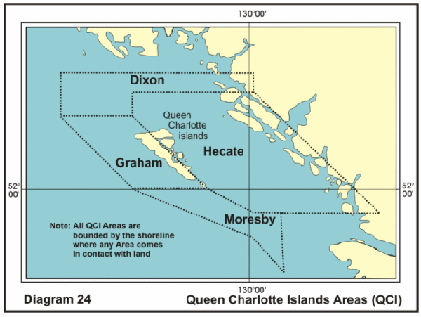
DIXON |
|
Chart |
54°25′00″N 134°00′00″W |
Sub surface operations area. |
24 |
|
HECATE |
|
Chart |
54°00′00″N 130°00′00″W |
Sub surface operations area. |
24 |
|
MORESBY |
|
Chart |
52°00′00″N 132°30′00″W |
Sub surface operations area. |
24 |
|
GRAHAM |
|
Chart |
53°30′00″N 134°00′00″W |
Sub surface operations area. |
24 |
|
Note:All
Queen Charlotte Island (QCI) Areas are bounded by the
shoreline where any area comes in |
|||||
Report a problem on this page
- Date modified: