
Archived information
The Standard on Web Usability replaces this content. This content is archived because Common Look and Feel 2.0 Standards have been rescinded.
Archived information is provided for reference, research or recordkeeping purposes. It is not subject to the Government of Canada Web Standards and has not been altered or updated since it was archived.
NOTICES TO MARINERS
PUBLICATION
WESTERN EDITION

Safety First, Service Always
Published Monthly by the
CANADIAN COAST GUARD
www.notmar.gc.ca/subscribe/
CONTENTS
| Section 1 | General and Safety Information |
| Section 2 | Chart Corrections |
| Section 3 | Radio Aids to Marine Navigation Corrections |
| Section 4 | Sailing Directions and Small Craft Guide Corrections |
| Section 5 | List of Lights, Buoys and Fog Signals Corrections |
Canadian Coast Guard Programs
Aids to Navigation and Waterways
Fisheries and Oceans Canada
Montreal, Quebec
H2Y 2E7
© Her Majesty the Queen in Right of Canada, 2016
DFO/2016-2003
Fs152-6E-PDF
ISSN 1719-7708
Disponible en français :
Publication des Avis aux navigateurs
Édition de l'Ouest
Édition mensuelle Nº07/2016
Fisheries and Oceans Canada
Official Publication of the Canadian Coast Guard
DFO/2018-2003
EXPLANATORY NOTES
Geographical positions refer directly to the graduations of the largest scale Canadian Hydrographic chart unless otherwise indicated.
Bearings refer to the true compass and are measured clockwise from 000° (North) clockwise to 359°; those relating to lights are from seaward.
Visibility of lights is that in clear weather.
Depths - The units used for soundings (metres, fathoms or feet) are stated in the title of each chart.
Elevations are normally given above Higher High Water, Large Tide unless otherwise indicated.
Distances may be calculated as follows:
1 nautical mile = 1,852 metres (6,076.1 feet)
1 statute mile = 1,609.3 metres (5,280 feet)
1 metre = 3.28 feet
Temporary & Preliminary Notices are indicated by a (T) or a (P) in Section 1, respectively. Please note that Nautical charts are not amended by the Canadian Hydrographic Service for Temporary (T) and Preliminary (P) Notices. It is recommended that mariners chart these corrections in pencil. The list of charts affected by Temporary and Preliminary Notices are revised and promulgated quarterly in Section 1 of the Monthly Edition.
Please note that, in addition to the temporary and preliminary changes normally advertised as (T) and (P) Notices, there are a few permanent changes to aids to navigation that have been advertised as Preliminary Notices to Mariners while charts are being updated for new editions.
Marine Information Report & Suggestion Sheet
Mariners are requested to notify the responsible authorities when new or suspected dangers to navigation are discovered, changes observed in aids to navigation or corrections to publications are seen
to be necessary. Such communications can be made using the Marine Information Report & Suggestion Sheet inserted on the last
page of each monthly edition of Notices to Mariners.
Canadian Hydrographic Service - Information Published in Section 2 of Notices to Mariners
Mariners are advised that only the most critical changes that directly affect safety to navigation are issued in Section 2 – Chart Corrections. This limitation
is required to ensure that charts remain as clear and easy to read as possible. As a result, mariners may see minor discrepancies of a
non-critical nature between information in official publications. For example, a small change in the nominal range or focal height of a light
may not result in the production of a chart correction in Notices to Mariners, but may result in a correction in the List of Lights, Buoys and
Fog Signals publication.
In case of discrepancy between information provided on CHS charts relating to aids to navigation, and the List of Lights, Buoys and Fog Signals publication, the latter shall be deemed as containing the most up-to-date information.
Canadian Nautical Charts & Publications
A source list of Canadian nautical charts and publications is published in Notice No. 14 of the Notices to Mariners Annual Edition 2018. The source supply and the prices
effective at the time of printing are listed. For current chart edition dates, please refer to the following website:
www.chs-shc.gc.ca/charts-cartes/paper-papier/index-eng.asp
CHART CORRECTIONS - SECTION 2
Corrections to nautical charts will be listed in numerical order by chart number. Each chart correction listed applies only to that particular chart. Related charts, if any, will have their own specific correction listed separately.
Users should also refer to CHS Chart 1: Symbols, Abbreviations and Terms for additional information pertaining to the correction of charts.
The illustration below describes the elements that will comprise a typical Section 2 chart correction:

The last correction number is identified with the LNM/D or Last Notice to Mariners Number / Date.
NOTICES TO MARINERS WEBSITE – MONTHLY EDITIONS, CHART CORRECTIONS, AND CHART PATCHES
The Notices to Mariners website allows users to access the monthly publications,
chart corrections, and chart patches.
Users can subscribe for free to the email notification service
to receive notifications when charts of interest are updated, including their patches, as well as when a new monthly edition becomes available online.
ADVISORY NOTICES TO SHIPPING (BROADCAST AND WRITTEN)
The Canadian Coast Guard is implementing a number of changes to the aids to navigation system in Canada.
These changes are advertised as Notices to Shipping (Broadcast and Written) by the Canadian Coast Guard, and are then followed up with Notices to Mariners, then charts are updated by hand correction, reprints or new editions.
Mariners are advised that all relevant Written Notices to Shipping should be kept until superseded by Notices to Mariners or through revised charts issued by the Canadian Hydrographic Service (CHS).
Written Notices to Shipping are available on the Canadian Coast Guard website at: www.ccg-gcc.gc.ca/eng/CCG/NOTSHIP.
The Canadian Hydrographic Service is reviewing the impact of these changes with the Canadian Coast Guard and together are preparing an action plan on the issuing of chart revisions.
For further information, contact your local Regional Notices to Shipping (NOTSHIP) issuing authorities.
Western
MCTS Western Regional Office
Canadian Coast Guard
Institute of Ocean Sciences
P.O. Box 6000
9860 West Saanich Rd.
Sidney, BC V8L 4B2
Telephone: (250) 363-8904 (Regional Administrative Assistant)
Email: NOTSHIP.Western@innav.gc.ca
* Iqaluit MCTS Centre
Operational from approximately mid-May until late December.
Canadian Coast Guard
P.O. Box 189
Iqaluit, NU X0A 0H0
“A” Series NOTSHIPs
Telephone: (867) 979-5269
Facsimile: (867) 979-4264
Email: IqaNordreg@innav.gc.ca
Website:
http://www.ccg-gcc.gc.ca/eng/CCG/Notship-Home
“H” Series NOTSHIPs
Telephone: (867) 979-0310
Facsimile: (867) 979-4264
Email: Iqamck01@innav.gc.ca
Website:
http://www.ccg-gcc.gc.ca/eng/CCG/Notship-Home
* Service available in English and French.
Index
NUMERICAL INDEX OF CANADIAN CHARTS AFFECTED
| 2260 | 3458 | 3603 | 3958 |
| 2261 | 3459 | 3668 | 3964 |
| 3000 | 3475 | 3675 | 3987 |
| 3001 | 3477 | 3724 | 6100 |
| 3311 | 3478 | 3726 | 6251 |
| 3313 | 3490 | 3795 | 6423 |
| 3441 | 3512 | 3808 | 6425 |
| 3442 | 3527 | 3909 | 6427 |
| 3443 | 3535 | 3956 | 7739 |
| 3447 | 3540 | 3957 | 7750 |
| 3456 |
SECTION 1 - GENERAL AND SAFETY INFORMATION
CANADIAN HYDROGRAPHIC SERVICE - ANNOUNCEMENT REGARDING CANADIAN HYDROGRAPHIC SERVICE CHART PATCHES
Colour Web Patches are free to the mariner, and given the quality of many printers, should reproduce well. They will be available in real time all around the world.
CHS welcomes your feedback on this service at chsinfo@dfo-mpo.gc.ca.
CANADIAN HYDROGRAPHIC SERVICE - CUMULATIVE CHART CORRECTIONS
The cumulative Notices to Mariners corrections for charts can now be accessed at
http://www.notmar.com/corrections-en.php.
CANADIAN HYDROGRAPHIC SERVICE - Current chart edition dates
CHART EDITIONS
The three terms described below are used to indicate the publication status of Canadian charts.
NEW CHART - "NEWCHT"
The first publication of a Canadian chart embracing an area not previously charted to the scale shown, or embracing an area different from any existing Canadian chart.
NEW EDITION - "NEWEDT"
A new issue of an existing chart containing amendments essential to navigation in addition to those issued in Notices to Mariners and making existing editions obsolete.
REPRINTS
A new issue of the current edition of a chart incorporating no amendments of navigational significance other than those previously promulgated in Notices to Mariners. It may also contain amendments from other sources provided they are not essential to navigation. Previous printings of the current edition remain in force.
The current chart edition dates can be accessed at www.chs-shc.gc.ca/charts-cartes/paper-papier/index-eng.asp
CANADIAN HYDROGRAPHIC SERVICE - PRINT ON DEMAND CHARTS - CARE AND USE
Background
By providing nautical charts to the public, the goal of the Canadian Hydrographic Service (CHS) is to provide services for safe navigation in a fiscally responsible manner. As a result, CHS continues to expand its portfolio of nautical paper charts that are printed using Print On Demand (POD) technology. These charts are easily recognized by their whiter paper and the coloured logo of the Canadian Hydrographic Service. This new technology enables CHS to print charts in a more efficient manner while enhancing chart content through being able to quickly add new and important information. POD technology provides customers with up-to-date charts without the historical hand-drawn corrections or glued-on patches. Additionally, this technology eliminates out-of-stock situations which arise with the traditional printing and warehousing methods. In the event of a national emergency, CHS can respond to the appropriate authorities with best available information very quickly.
Care of Your POD Chart
CHS encourages its customers to handle the POD charts more carefully than the traditional lithographic charts. When plotting information on POD charts, use HB pencils and apply limited pressure. Testing has suggested that an Indian gum eraser is more effective than alternatives when used on the product. This eraser is also suitable for charts printed using lithographic processes.
CANADIAN HYDROGRAPHIC SERVICE - TRANSPORT CANADA NAVIGATION SAFETY - ECDIS
Mariners are advised that ECDIS may not display some isolated shoal depths when operating in "base or standard display" mode. Route planning and monitoring alarms for these shoal depths may not always be activated. To ensure safe navigation and to confirm that a planned route is clear of such dangers, mariners should visually inspect the planned route and any deviations from it using ECDIS configured to display "all data". The automated voyage planning check function should not be solely relied upon.
UPDATE TO CONSOLIDATION OF MARINE COMMUNICATIONS AND TRAFFIC SERVICES (MCTS) CENTRES.
The Canadian Coast Guard is modernizing and consolidating its Marine Communications and Traffic Services Centres. Clients will continue to receive the high-quality service they have come to expect.
Once complete, there will be a total of 12 MCTS Centres strategically located across the country. Additional information pertaining to this project will be advertised to clients by all available means.
Western Region
Comox MCTS will consolidate to Victoria MCTS in Winter/Spring 2016
The new technology will increase efficiency permitting employees to have a greater ability to focus on the safety services they provide to mariners. Mariners are encouraged to visit the Radio Aids to Marine Navigation (RAMN), www.ccg-gcc.gc.ca/Marine-Communications/Home and Notices to Mariners (NOTMAR), www.notmar.gc.ca PART 3 on a monthly basis for updated information and potential changes to contact information and marine broadcast schedules.
CANADIAN HYDROGRAPHIC SERVICE – ANNOUNCEMENT REGARDING TIDAL INFORMATION TABLES ON CHARTS.
Mariners are advised that the tidal levels listed in the 2016 edition of canadian tide and current tables, volumes 2 and 3 have been updated. This revision is aimed to get more precise tidal predictions in time and height. this will result in corrections to the tidal information table shown on charts. These corrections will be published in 2016, through notices to mariners.
ERRATUM:
Take note that notices to mariners regarding the chart 3313 (sheet 11 and 12) on June 24th 2016 should have been published in the Monthly Notices to Mariners, No. 6, 2016, Part 2. The information about this chart is published in the current edition.
*701 CANADIAN HYDROGRAPHIC SERVICE – NAUTICAL CHARTS
| CARTES | MAIN TITLE | SCALE | PUBLISHED | CAT # | PRICE |
|---|---|---|---|---|---|
| New Charts | |||||
| 7739 | James Ross Strait | 1:80000 | 26-FEB-2016 | ||
| New Editions | |||||
| 2260 | Sarnia to/à Bayfield | 1:80000 | 15-APR-2016 | 3 | 12.00 |
| 2261 | Bayfield to/à Douglas Point | 1:80000 | 30-JUN-2016 | 3 | 12.00 |
| 3540 | Approaches to/Approches à Campbell River | 1:10000 | 01-FEB-2016 | 2 | 20.00 |
| 6100 | Lac Saint-Jean | 1:120000 | 15-APR-2016 | 1 | 28.00 |
| 6423 | Askew Islands to/à Bryan Island Kilometre 1180 / Kilometre 1240 | 1:50000 | 15-JAN-2016 | 4 | 12.00 |
| 6425 | Travaillant River to/à Adam Cabin Creek Kilometre 1325 / Kilomètre 1400 | 1:50000 | 15-JAN-2016 | 4 | 12.00 |
| 6427 | Point Separation to/au Aklavik Channel Kilometre 1480 / Kilomètre 1540 | 1:50000 | 15-JAN-2016 | 4 | 12.00 |
*702 CANADIAN HYDROGRAPHIC SERVICE - ELECTRONIC NAVIGATIONAL CHARTS.
| NEW PRODUCTS | |
|---|---|
| S-57 ENC NUMBER | CHART TITLE |
| CA579157 | Carillon à/to L'Orignal |
| CA579158 | L'Orignal à/to Papineauville |
| CA579159 | Papineauville à/to Becketts Creek |
| CA579160 | Becketts Creek à/to Ottawa |
| WITHDRAWN PRODUCTS | |
| CA576342 | Botwood Harbour |
| CA576343 | Botwood Wharves |
| CA579204 | Carillon |
*703 SHIP SAFETY BULLETINS (TP 3231) – 2016
Ship Safety Bulletins address safety-related matters pertaining to vessels. Bulletins are available from
Transport Canada’s Marine Safety Directorate free of charge and are issued on an "as needed" basis. A complete
list of Ship Safety Bulletins is available on Transport Canada’s Web site at:
http://www.tc.gc.ca/eng/marinesafety/bulletins-menu.htm
If you do not have access to our Web site and wish to be included in the Ship Safety Bulletins mailing list, please send your request to the Marine Safety location provided below. We ask your cooperation in distributing copies of this listing to your colleagues, to ship owners and/or maritime companies to let them know of the existence of these Bulletins.
If this is the first time you are receiving the Bulletin, your name is probably not on Transport Canada’s mailing list. Should you wish to be included, please send your request to the Marine Safety location provided below.
How to stay up-to-date on newly published bulletins.
To receive Ship Safety Bulletins electronically, select the following Internet address and follow the instructions
on how to sign up for e-Bulletin or RSS feed services.
E-Bulletin sends a notice to your e-mail address inbox, whereas RSS feed sends a notice to your Internet
browser when a new SSB becomes available on our Internet at:
http://www.tc.gc.ca/eng/marinesafety/bulletins-menu.htm.
As of June 30, 2016, the following Ship Safety Bulletins have been issued:
| Bulletin No. | Bulletin Title | Date |
|---|---|---|
| 01/2016 | Large Fishing Vessels – Efficient Bilge Drainage Systems in all Watertight and Refrigerated Spaces | 2016-01-20 |
| 02/2016 | Streamlined Application Process for a Candidate Document Number (CDN) | 2016-04-08 |
| 03/2016 | 2016/17 Concentrated Inspection Campaign | 2016-05-05 |
| 04/2016 | Canadian Procedures for Verification of the Gross Mass of Packed Containers | 2016-05-12 |
Transport Publications (TPs) New and/or Updated – 2016
| Publication No | Title | Date |
|---|---|---|
| TP 15330 | Canadian Procedure for obtaining the verified Gross mass of packed containers as required by SOLAS VI/2 New | 2016 |
| TP 15287 | TERMPOL Review Process on the LNG Canada Project New | 2015 |
Copies of these publications may be obtained from:
Transports Canada
Marine Safety Directorate (AMSIA)
Place de Ville, Tower “C”
330 Sparks Street, 9th floor
Ottawa, Ontario, K1A 0N5
Website: Ship Safety Bulletins: :
Site web:
http://www.tc.gc.ca/eng/marinesafety/menu.htm
Publication de transports:
http://www.tc.gc.ca/eng/marinesafety/tp-menu-515.htm
Email : marinesafety-securitemaritime@tc.gc.ca
Telephone : 613-991-3135
Toll Free (Marine) : 1-866-995-9737
Teletypewrier (TTY) : 1-888-675-6863
Fax : 613-990-1879
*704 ANNUAL EDITION NOTICES TO MARINERS 1 TO 46 – NEW NOTICE 5D HAS BEEN ADDED IN SECTION A.2 PAGE 61 OF 67
GENERAL GUIDELINES FOR NATIONAL WILDLIFE AREAS.
National Wildlife Areas of Canada
National Wildlife Areas (NWAs) are protected and managed according to the
Wildlife Area Regulationsunder the Canada Wildlife Act.
The primary purpose of most NWAs is the protection and conservation of wildlife and their habitat. For this purpose,
and according to the legislation, activities that could interfere with the conservation of wildlife are prohibited in an
NWA. Consequently, a few NWAs are not accessible to the public and there are prohibited activities in all of them.
Nonetheless, the Minister of the Environment has the ability to authorize most of the activities, whether through
public notice or the issuance of permits. Those activities benefiting wildlife and their habitat, or are not inconsistent
with the purpose for which the NWA was established and are consistent with the management plan goals for the NWA may be permitted.
For general information regarding Canada’s National Wildlife Areas, please contact Environment and Climate Change
Canada at 1-800-668-6767 (in Canada only) or ec.enviroinfo.ec@canada.ca,
or visit our website: www.ec.gc.ca.
General Guidelines for National Wildlife Areas in Nunavut
Canadian and foreign ships are not allowed to enter these protected areas without a permit. Any foreign ship captain who is planning to enter in any of these protected areas without a permit, claiming a right of innocent passage, is strongly advised to communicate with Environment and Climate Change Canada (Canadian Wildlife Service) at least two weeks in advance.
In the Nunavut territory, Inuit have certain rights as per the Nunavut Land Claims Agreement (NLCA) and the Inuit Impact and Benefit Agreement (IIBA).
Akpait National Wildlife Area
Coordinates
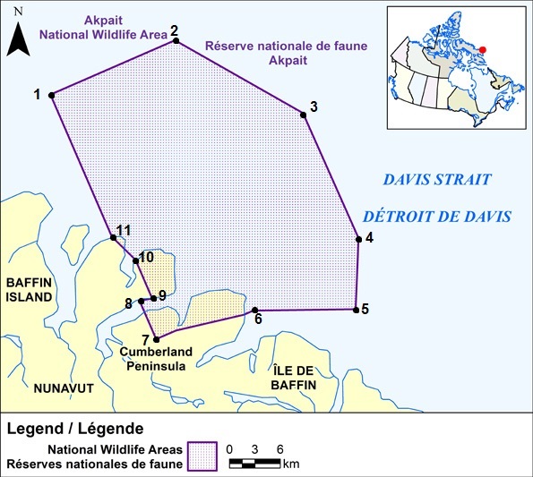
All geographic coordinates (latitude and longitude) are expressed in the North American Datum 1983 (NAD 83) geodetic reference system.
| Point | Latitude | Longitude |
|---|---|---|
| 1 | 67°08′00″ N | 61°51′00″ W |
| 2 | 67°08′00″ N | 61°29′06″ W |
| 3 | 67°00′35″ N | 61°15′00″ W |
| 4 | 66°52′00″ N | 61°15′00″ W |
| 5 | 66°48′00″ N | 61°20′00″ W |
| 6 | 66°50′30″ N | 61°35′00″ W |
| 7 | 66°51′17″ N | 61°51′00″ W |
| 8 | 66°53′55″ N | 61°51′00″ W |
| 9 | 66°53′43″ N | 61°49′00″ W |
| 10 | 66°56′21″ N | 61°49′00″ W |
| 11 | 66°58′17″ N | 61°51′00″ W |
Prohibitions
Navigating within Akpait National Wildlife Area without a permit is prohibited except for Inuit exercising their rights as per the Nunavut Land Claims Agreement or the Inuit Impact and Benefit Agreement.
Permitting Requirements
A permit must be obtained to either navigate within or conduct any type of activity in the National Wildlife Area.
Activities that may be permitted will be in accordance with the conservation objectives of the National Wildlife
Area management plan. A permit is not required for Inuit exercising their rights as per the Nunavut Land Claims
Agreement or the Inuit Impact and Benefit Agreement within the National Wildlife Area.
More information on access and permitting for Akpait National Wildlife Area can be obtained by contacting the
Environment and Climate Change Canada regional office.
Contact Information
Environment and Climate Change Canada – Prairie Northern Region
Canadian Wildlife Service
Protected Areas and Stewardship
P. O. Box 1714
Iqaluit, Nunavut,X0A 0H0
Toll Free: 1-800-668-6767 (in Canada only)
Email : ec.enviroinfo.ec@canada.ca
Ninginganiq National Wildlife Area
Coordinates

All latitudes and longitudes hereinafter are referred to the North American Datum of 1983, Canadian Spatial Reference System (NAD83(CSRS)
| Point | Latitude | Longitude |
|---|---|---|
| 1 | 69°50′00″ N | 67°13′16.87″ W |
| 2 | 69°50′00″ N | 66°36′03″ W |
| 3 | 69°17′00″ N | 66°07′13″ W |
| 4 | 69°17′00″ N | 66°44′03.04″ W |
| 5 | 69°34′43.78″ N | 68°40′00″ W |
| 6 | 69°39′27.57″ N | 68°40′00″ W |
Prohibitions
Navigating within Ninginganiq National Wildlife Area without a permit is prohibited except for Inuit exercising their rights as per the Nunavut Land Claims Agreement or the Inuit Impact and Benefit Agreement.
Permitting Requirements
A permit must be obtained to either navigate within or conduct any type of activity in the National Wildlife Area.
Activities that may be permitted will be in accordance with the conservation objectives of the National Wildlife
Area management plan. A permit is not required for Inuit exercising their rights as per the Nunavut Land Claims
Agreement or the Inuit Impact and Benefit Agreement within the National Wildlife Area.
More information on access and permitting for Ninginganiq National Wildlife Area can be obtained by contacting
the Environment and Climate Change Canada regional office.
https://ec.gc.ca/ap-pa/default.asp?lang=En&n=47D87A04-1#_005
Contact Information
Environment and Climate Change Canada – Prairie Northern Region
Canadian Wildlife Service
Protected Areas and Stewardship
P. O. Box 1714
Iqaluit, Nunavut,X0A 0H0
Toll Free: 1-800-668-6767 (in Canada only)
Email : ec.enviroinfo.ec@canada.ca
Nirjutiqavvik National Wildlife Area
Coordinates
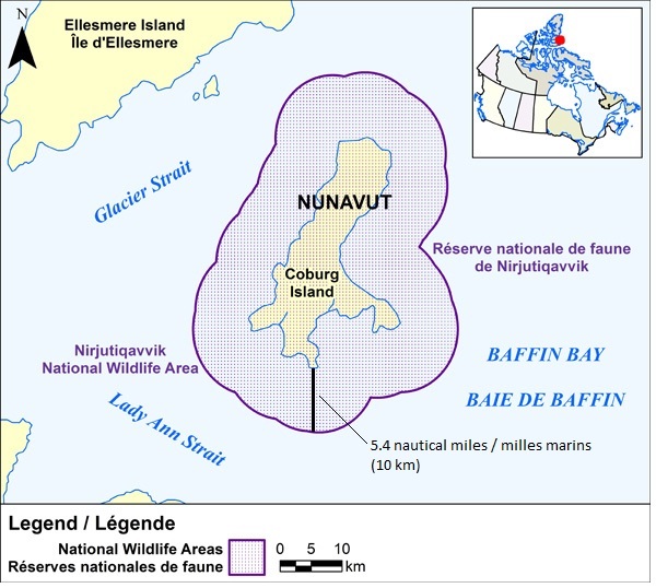
All latitudes and longitudes hereinafter described refer to the 1927 North American Datum.
All of the island known as Coburg Island, the centre of which having approximate latitude 75°57′50″ and approximate longitude 79°19′30″; and also all that land covered by water immediately adjacent to said Coburg Island and extending 10 km (5.4 Nautical Miles) from the ordinary high-water mark thereof.
Prohibitions
Navigating within Nirjutiqavvik National Wildlife Area without a permit is prohibited except for Inuit exercising their rights as per the Nunavut Land Claims Agreement or the Inuit Impact and Benefit Agreement.
Permitting Requirements
A permit must be obtained to either navigate within or conduct any type of activity in the National Wildlife Area.
Activities that may be permitted will be in accordance with the conservation objectives of the National Wildlife Area management plan.
A permit is not required for Inuit exercising their rights as per the Nunavut Land Claims Agreement or the Inuit
Impact and Benefit Agreement within the National Wildlife Area.
More information on access and permitting for Nirjutiqavvik National Wildlife Area can be obtained by contacting the
Environment and Climate Change Canada regional office.
Contact Information
Environment and Climate Change Canada – Prairie Northern Region
Canadian Wildlife Service
Protected Areas and Stewardship
P. O. Box 1714
Iqaluit, Nunavut,X0A 0H0
Toll Free: 1-800-668-6767 (in Canada only)
Email : ec.enviroinfo.ec@canada.ca
Qaqulluit National Wildlife Area
Coordinates

All latitudes and longitudes hereinafter are referred to the North American Datum of 1983, Canadian Spatial Reference System (NAD83(CSRS));
| Point | Latitude | Longitude |
|---|---|---|
| 1 | 67°17′13.53″ N | 62°47′28.04″ W |
| 2 | 67°21′05.00″ N | 62°37′07.13″ W |
| 3 | 67°21′40.56″ N | 62°22′47.50″ W |
| 4 | 67°18′24.40″ N | 62°11′09.29″ W |
| 5 | 67°13′05.16″ N | 62°07′02.76″ W |
| 6 | 67°08′01.14″ N | 62°12′15.74″ W |
| 7 | 67°10′31.73″ N | 62°21′46.00″ W |
| 8 | 67°11′35.41″ N | 62°21′58.76″ W |
| 9 | 67°12′15.21″ N | 62°23′25.39″ W |
| 10 | 67°12′38.43″ N | 62°25′04.87″ W |
| 11 | 67°11′38.90″ N | 62°26′01.70″ W |
Prohibitions
Navigating within Qaqulluit National Wildlife Area without a permit is prohibited except for Inuit exercising their rights as per the Nunavut Land Claims Agreement or the Inuit Impact and Benefit Agreement.
Permitting Requirements
A permit must be obtained to either navigate within or conduct any type of activity in the National Wildlife Area. Activities that may be permitted will be in accordance with the conservation objectives of the National Wildlife Area management plan. A permit is not required for Inuit exercising their rights as per the Nunavut Land Claims Agreement or the Inuit Impact and Benefit Agreement within the National Wildlife Area.
More information on access and permitting for Qaqulluit National Wildlife Area can be obtained by contacting the
Environment and Climate Change Canada regional office.
Contact Information
Environment and Climate Change Canada – Prairie Northern Region
Canadian Wildlife Service
Protected Areas and Stewardship
P. O. Box 1714
Iqaluit, Nunavut,X0A 0H0
Toll Free: 1-800-668-6767 (in Canada only)
Email : ec.enviroinfo.ec@canada.ca
Polar Bear Pass National Wildlife Area
Coordinates
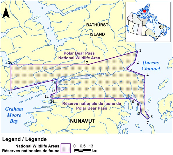
All coordinates quoted herein being Universal Transverse Mercator coordinates in Zone 14;
| Point | Northing | Easting |
|---|---|---|
| 1 | 8 421 000 | 540 000 |
| 2 | 8 412 000 | 537 600 |
| 3 | 8 406 700 | 531 300 |
| 4 | 8 401 500 | 545 500 |
| 5 | 8 373 800 | 545 700 |
| 6 | 8 368 700 | 549 200 |
| 7 | 8 367 000 | 548 000 |
| 8 | 8 372 000 | 542 500 |
| 9 | 8 380 000 | 541 600 |
| 10 | 8 383 300 | 536 200 |
| 11 | 8 383 300 | 472 600 |
| 12 | 8 384 900 | 470 900 |
| 13 | 8 386 100 | 470 800 |
| 14 | 8 388 100 | 475 600 |
| 15 | 8 398 600 | 476 400 |
| 16 | 8 390 000 | 440 000 |
| 17 | 8 410 000 | 500 000 |
All latitudes and longitudes hereinafter are referred to the North American Datum of 1983, Canadian Spatial Reference System (NAD83(CSRS));
Prohibitions
Navigating within Polar Bear Pass National Wildlife Area without a permit is prohibited except for Inuit exercising their rights as per the Nunavut Land Claims Agreement or the Inuit Impact and Benefit Agreement.
Permitting Requirements
A permit must be obtained to either navigate within or conduct any type of activity in the National Wildlife Area. Activities that may be permitted will be in accordance with the conservation objectives of the National Wildlife Area management plan. A permit is not required for Inuit exercising their rights as per the Nunavut Land Claims Agreement or the Inuit Impact and Benefit Agreement within the National Wildlife Area.
More information on access and permitting for Polar Bear Pass National Wildlife Area can be obtained by contacting the
Environment and Climate Change Canada regional office.
Contact Information
Environment and Climate Change Canada – Prairie Northern Region
Canadian Wildlife Service
Protected Areas and Stewardship
P. O. Box 1714
Iqaluit, Nunavut,X0A 0H0
Toll Free: 1-800-668-6767 (in Canada only)
Email : ec.enviroinfo.ec@canada.ca
*705 CANADIAN COAST GUARD - LIST OF CHARTS AND REFERENCE CHARTS (SECTION I) AFFECTED BY TEMPORARY AND PRELIMINARY NOTICES
IN EFFECT JULY 29th, 2016
(REVISED AND PROMULGATED QUARTERLY)
| 1430 | 809(P)/15 |
| 2017 | 909(T)/14 |
| 2044 | 1005(T)/15 |
| 2315 | 1006(T)/15 515(T)/16 |
| 3057 | 209(P)/16 |
| 3478 | 1013(P)/15 |
| 3490 | 1112(P)/14 |
| 3538 | 712(P)/15 |
| 3546 | 714(P)/14 |
| 3668 | 1213(P)/14 718(P)/16 |
| 3800 | 115(P)/16 |
| 4010 | 605(P)/14 1108(P)/15 |
| 4170 | 1109(P)/15 |
| 4201 | 509(P)/13 |
| 4211 | 1205(P)/15 |
| 4236 | 609(P)/15 610(P)/15 |
| 4241 | 810(P)/14 808(P)/15 |
| 4237 | 516 (P)/16 |
| 4244 | 1006(T)/14 904(P)/15 |
| 4302 | 303(T)/16 |
| 4340 | 418(P)/14 |
| 4367 | 1008(P)/15 |
| 4374 | 508(P)/15 |
| 4375 | 411(P)/15 1004(P)/15 113(P)/16 |
| 4376 | 302(P)/16 |
| 4377 | 405(P)/13 |
| 4385 | 202(P)/15 |
| 4386 | 1108(P)/13 507(P)/14 |
| 4396 | 709(P)/14 |
| 4404 | 611(P)/16 |
| 4422 | 1005(P)/14 |
| 4425 | 517(P)/16 |
| 4507 | 715(P)/16 |
| 4512 | 1007(P)/15 |
| 4597 | 1003(P)/09 |
| 4644 | 1106(T)/15 |
| 4825 | 110(T)/16 717(P)/16 |
| 4830 | 1104(T)/13 716(P)/16 |
| 4863 | 109(T)/16 |
| 4909 | 613(P)/12 810(P)/12 714(P)/16 |
| 4911 | 510(P)/15 811(P)/12 515(P)/15 |
| 4912 | 516(P)/15 |
| 4913 | 518(P)/16 519(P)/16 |
| 4920 | 520(P)/16 |
| 5051 | 1208(T)/13 |
| 6218 | 204(T)/16 |
| 6267 | 1114(P)/14 |
| 8010 | 610(T)/16 |
| US 14832 | 712(T)/14 |
| US 14884 | 715(T)/13 |
| US 14853 | 1211(T)/14 |
| US 14865 | 807(T)/15 |
*706 CANADIAN HYDROGRAPHIC SERVICE – SAILING DIRECTIONS – CEN 308 — RIDEAU CANAL AND OTTAWA RIVER, FIRST EDITION, 2003 IS NOW AVAILABLE AS A PRINT-ON-DEMAND (POD) PRODUCT.
The Sailing Directions booklet CEN 308 — Rideau Canal and Ottawa River, First Edition, 2003 is now available as Print-on-Demand (POD) product. POD booklets are updated through Notices to Mariners to the date of printing. For instance, the POD version of CEN 308 now incorporates some 202 Notices to Mariners issued since 2003, which previously had to be manually added to the book. The Canadian Hydrographic Service (CHS) is converting all of its Sailing Directions to the POD format in response to requests received through our Level of Service initiative. Contact an authorized CHS dealer to purchase a new copy.
Please note that despite the new look, the content remains the same except that the Notices to Mariners have been incorporated up to the date of printing.
*713 FRASER RIVER/FLEUVE FRASER, SAND HEADS TO/À DOUGLAS ISLAND – ADVERTISMENT OF PROPOSED CHANGES.
Reference Chart: 3490
The Canadian Coast Guard advises that the following aid to navigation which was proposed for permanent discontinuance will remain in service:
Annieville Rock Wall #5 (LL 5235) (49° 11’ 59.5’’N 122° 54’ 04.1’’W
Previous notice 213(P)/15 is cancelled.
(P2016-048)
*718(P) ALBERNI INLET – DAYBEACONS TO BE DISCONTINUED.
Reference Chart: 3668
The Canadian Coast Guard proposes to discontinue the following aids to navigation:
Somass River Norske Daybeacon #4 (LL 5079) (49° 14’ 29.8’’N 124° 49’ 20.3’’W)
Somass River Norske Daybeacon #6 (LL 5079.4) (49° 14’ 39.8’’N 124° 49’ 18.8’’W)
Somass River Norske Daybeacon #7 (LL 5079.6) (49° 14’ 44.8’’N 124° 49’ 11.6’’W)
Comments on this action are solicited from mariners and other interested parties.
Comments should be directed to the following within three months from the date of this notice:
Superintendent, Kevin Carrigan
Aids & Waterways, Western Region
Canadian Coast Guard
Victoria, BC V8V 4V9
Telephone: 250-480-2602
Fax : 250-480-2702
Email : kevin.carrigan@dfo-mpo.gc.ca
Any objections must state the facts on which they are based and should include supporting information on safety, commerce and public benefit.
(P2016-046)
SECTION 2 - CHART CORRECTIONS
3000 - Juan de Fuca Strait to/à Dixon Entrance - New Edition - 20-JAN-1989 - NAD 1927
| 22-JUL-2016 | LNM/D. 01-JAN-2016 | ||
| Replace |
EXERCISE AREA WP ZONE D′EXERCICES WP With EXERCISE AREA WP Surface and air firings may be conducted in any part of WP if appropriate clearances have been obtained. However, the majority of firings are carried out in two areas designated West Coast Firing Area North (WCFA North), and West Coast Firing Area South (WCFA South) Pecked lines enclose these areas. For information concerning firing operations call Prince Rupert Traffic on VHF, Channel 74. ZONE D′EXERCICES WP Les tirs de surface et aériens peuvent être exécutés dans n'′importe quelle partie de la zone WP à condition d'′avoir obtenu l’autorisation appropriée. Toutefois, la plupart des tirs sont exécutés à l′intérieur de deux zones désignées West Coast Firing Area North (WCFA North) et West Coast Firing Area South (WCFA South) où des tiretés délimitent ces zones. Pour obtenir des renseignements concernant les exercices de tir, communiquer avec Prince Rupert Traffic par radio VHF, voie 74. |
53°41′00.0″N 126°00′00.0″W | |
| DFO(6203306-05) | |||
3001 - Vancouver Island / Île de Vancouver, Juan de Fuca Strait to/à Queen Charlotte Sound - New Edition - 23-FEB-2001 - NAD 1927
| 22-JUL-2016 | LNM/D. 01-JAN-2016 | ||
| Replace |
EXERCISE AREA WP ZONE D′EXERCICES WP With EXERCISE AREA WP Surface and air firings may be conducted in any part of WP if appropriate clearances have been obtained. However, the majority of firings are carried out in two areas designated West Coast Firing Area North (WCFA North), and West Coast Firing Area South. (WCFA South). Pecked lines enclose these areas. For information concerning firing operations call Prince Rupert Traffic on VHF, Channel 74. ZONE D′EXERCICES WP Les tirs de surface et aériens peuvent être exécutés dans n’′importe quelle partie de la zone WP à condition d'′avoir obtenu l’autorisation appropriée. Toutefois, la plupart des tirs sont exécutés à l′intérieur de deux zones désignées West Coast Firing Area North (WCFA North) et West Coast Firing Area South (WCFA South) où des tiretés délimitent ces zones. Pour obtenir des renseignements concernant les exercices de tir, communiquer avec Prince Rupert Traffic par radio VHF, voie 74. |
49°52′30.0″N 122°54′00.0″W | |
| This notice affects Electronic Navigational Chart: CA270389 | |||
| DFO(6203306-06) | |||
3311 - Pender Harbour - Sheet/Feuille 4 - New Edition - 31-DEC-1993 - NAD 1983
| 08-JUL-2016 | LNM/D. 03-JUN-2016 | ||
| Add |
depth of 1.3 metres
(See Chart No. 1, I10) |
49°37′29.5″N 124°01′48.0″W | |
| This notice affects Electronic Navigational Chart: CA570544 | |||
| DFO(6203295-01) | |||
3313 - Swanson Channel - Sheet/Feuille 8 - New Edition - 02-JAN-2009 - NAD 1983
| 15-JUL-2016 | LNM/D. 08-JUL-2016 | ||
| Delete |
depth of 0.3 metres
(See Chart No. 1, I10) |
48°50′49.8″N 123°29′31.8″W | |
| This notice affects Electronic Navigational Chart: CA470005, CA570239 | |||
| DFO(6203308-01) | |||
| Add |
wreck showing a portion of superstructure at chart datum
(See Chart No. 1, K24) |
48°50′49.9″N 123°29′34.1″W | |
| This notice affects Electronic Navigational Chart: CA470005, CA570239 | |||
| DFO(6203308-02) | |||
3313 - Captain Passage - Sheet/Feuille 10 - New Edition - 02-JAN-2009 - NAD 1983
| 15-JUL-2016 | LNM/D. 08-JUL-2016 | ||
| Delete |
depth of 0.3 metres
(See Chart No. 1, I10) |
48°50′49.8″N 123°29′31.8″W | |
| This notice affects Electronic Navigational Chart: CA470005, CA570239 | |||
| DFO(6203308-01) | |||
| Add |
wreck showing a portion of superstructure at chart datum
(See Chart No. 1, K24) |
48°50′49.9″N 123°29′34.1″W | |
| This notice affects Electronic Navigational Chart: CA470005, CA570239 | |||
| DFO(6203308-02) | |||
3313 - Plumper Sound - Sheet/Feuille 11 - New Edition - 02-JAN-2009 - NAD 1983
| 24-JUN-2016 |
LNM/D. 17-JUIN-2016 |
||||
| Add |
depth of 9.1 metres
(See Chart No. 1, I10) |
48°47′47.3″N 123°12′28.1″W |
|||
| This notice affects Electronic Navigational Chart: CA570186 | |||||
|
DFO(6203287-01) |
|||||
3313 - Plumper Sound - Sheet/Feuille 11 - New Edition - 02-JAN-2009 - NAD 1983
| 15-JUL-2016 |
LNM/D. 08-JUL-2016 |
||||
| Add |
wreck with known depth of 5.1 metres
(See Chart No. 1, K26) |
48°46′23.6″N 123°16′26.6″W |
|||
| This notice affects Electronic Navigational Chart: CA570186 | |||||
|
DFO(6203307-01) |
|||||
| 08-JUL-2016 |
LNM/D. 01-JUL-2016 |
||||
| Add |
wreck with known depth of 4.5 metres
(See Chart No. 1, K26) |
48°49′45.0″N 123°14′52.9″W |
|||
| This notice affects Electronic Navigational Chart: CA470005, CA570186 | |||||
|
DFO(6203292-01) |
|||||
| Reposition |
reported anchorage
(See Chart No. 1, N10) |
from 48°49′47.0″N 123°12′53.5″W
|
|||
|
DFO(6203292-03) |
|||||
| Add |
wreck with known depth of 5.2 metres
(See Chart No. 1, K26) |
48°46′20.4″N 123°16′19.7″W |
|||
| This notice affects Electronic Navigational Chart: CA570186 | |||||
|
DFO(6203297-01) |
|||||
| Add |
wreck with known depth of 5.2 metres
(See Chart No. 1, K26) |
48°46′33.1″N 123°16′05.3″W | |||
| This notice affects Electronic Navigational Chart: CA570186 | |||||
|
DFO(6203297-04) |
|||||
| Delete |
underwater rock of unknown depth, dangerous to surface navigation
(See Chart No. 1, K13) |
48°49′30.3″N 123°14′01.7″W | |
| This notice affects Electronic Navigational Chart: CA470005, CA570186 | |||
| DFO(6203299-01) | |||
| Add |
depth of 0.8 metres
(See Chart No. 1, I10) |
48°49′30.2″N 123°14′02.9″W | |
| This notice affects Electronic Navigational Chart: CA470005, CA570186 | |||
| DFO(6203299-02) | |||
| 01-JUL-2016 | LNM/D. 24-JUN-2016 | ||
| Add |
wreck with known depth of 2.0 metres
(See Chart No. 1, K26) |
48°48′32.3″N 123°11′44.1″W | |
| This notice affects Electronic Navigational Chart: CA470005, CA570186 | |||
| DFO(6203290-01) | |||
| Delete |
depth of 4.0 metres
(See Chart No. 1, I10) |
48°48′31.0″N 123°11′42.0″W | |
| DFO(6203290-02) | |||
| Add |
rock awash at chart datum
(See Chart No. 1, K12) |
48°48′47.8″N 123°11′39.9″W | |
| This notice affects Electronic Navigational Chart: CA470005, CA570186 | |||
| DFO(6203290-04) | |||
3313 - Georgeson Passage - Sheet/Feuille 12 - New Edition - 02-JAN-2009 - NAD 1983
| 24-JUN-2016 | LNM/D. 17-JUIN-2016 | ||||
| Add |
depth of 1.9 metres
(See Chart No. 1, I10) |
48°47′47.3″N 123°12′28.1″W | |||
| This notice affects Electronic Navigational Chart: CA570186 | |||||
|
DFO(6203287-01) |
|||||
3313 - Georgeson Passage - Sheet/Feuille 12 - New Edition - 02-JAN-2009 - NAD 1983
| 08-JUL-2016 | LNM/D. 01-JUL-2016 | ||||
| Add |
wreck with known depth of 4.5 metres
(See Chart No. 1, K26) |
48°49′45.0″N 123°14′52.9″W | |||
| This notice affects Electronic Navigational Chart: CA470005, CA570186 | |||||
|
DFO(6203292-01) |
|||||
| Reposition |
reported anchorage
(See Chart No. 1, N10) |
from 48°49′44.0″N 123°14′52.5″W
|
|||
|
DFO(6203292-03) |
|||||
| Delete |
underwater rock of unknown depth, dangerous to surface navigation
(See Chart No. 1, K13) |
48°49′30.3″N 123°14′01.7″W | |||
| This notice affects Electronic Navigational Chart: CA470005, CA570186 | |||||
|
DFO(6203299-01) |
|||||
| Add |
depth of 0.8 metres
(See Chart No. 1, I10) |
48°49′30.2″N 123°14′02.9″W |
|||
| This notice affects Electronic Navigational Chart: CA470005, CA570186 | |||||
|
DFO(6203299-02) |
|||||
| 01-JUL-2016 | LNM/D. 24-JUN-2016 | ||||
| Add |
wreck with known depth of 2.0 metres
(See Chart No. 1, K26) |
48°48′32.3″N 123°11′44.1″W | |||
| This notice affects Electronic Navigational Chart: CA470005, CA570186 | |||||
|
DFO(6203290-01) |
|||||
| Delete |
depth of 4.0 metres
(See Chart No. 1, I10) |
48°48′31.0″N 123°11′42.0″W | |||
|
DFO(6203290-02) |
|||||
| Delete |
depth of 2.4 metres
(See Chart No. 1, I10) |
48°48′47.6″N 123°11′39.2″W | |
| This notice affects Electronic Navigational Chart: CA470005, CA570186 | |||
| DFO(6203290-03) | |||
| Add |
rock awash at chart datum
(See Chart No. 1, K12) |
48°48′47.8″N 123°11′39.9″W | |
| This notice affects Electronic Navigational Chart: CA470005, CA570186 | |||
| DFO(6203290-04) | |||
3313 - Approaches to/Approches à Nanaimo - Sheet/Feuille 20 - New Edition - 02-JAN-2009 - NAD 1983
| 29-JUL-2016 |
LNM/D. 15-JUL-2016 |
|||||
| Add |
wreck with known depth of 105 metres
(See Chart No. 1, K26) |
49°09′17.5″N 123°51′37.6″W |
||||
| This notice affects Electronic Navigational Chart: CA470070, CA570156 | ||||||
|
DFO(6203311-01) |
||||||
| Replace |
light Fl G and radar reflector with port hand daybeacon
(See Chart No. 1 P1, S4, Qt) |
49°09′48.4″N 123°55′15.7″W |
||||
|
DFO(6203312-01) |
||||||
| 08-JUL-2016 |
LNM/D. 01-JUL-2016 |
|||||
| Add |
wreck with known depth of 67 metres
(See Chart No. 1, K26) |
49°08′55.1″N 123°50′47.0″W |
||||
| This notice affects Electronic Navigational Chart: CA470070, CA570156 | ||||||
|
DFO(6203300-01) |
||||||
3313 - Nanaimo Harbour and/et Departure Bay - Sheet/Feuille 21 - New Edition - 02-JAN-2009 - NAD 1983
| 01-JUL-2016 | LNM/D. 24-JUN-2016 | ||
| Delete |
depth of 0.9 metres
(See Chart No. 1, I10) |
49°09′50.2″N 123°55′12.5″W | |
| This notice affects Electronic Navigational Chart: CA570383 | |||
| DFO(6203291-01) | |||
| Add |
depth of 0.6 metres
(See Chart No. 1, I10) |
49°09′50.5″N 123°55′12.1″W | |
| This notice affects Electronic Navigational Chart: CA470070, CA570383 | |||
| DFO(6203291-02) | |||
3441 - Haro Strait, Boundary Pass and/et Satellite Channel - New Edition - 01-JUL-2005 - NAD 1983
| 15-JUL-2016 | LNM/D. 08-JUL-2016 | ||
| Add |
wreck with known depth of 5.1 metres
(See Chart No. 1, K26) |
48°46′23.6″N 123°16′26.6″W | |
| This notice affects Electronic Navigational Chart: CA570186 | |||
| DFO(6203307-01) | |||
| 08-JUL-2016 | LNM/D. 24-JUN-2016 | ||
| Add |
wreck with known depth of 5.2 metres
(See Chart No. 1, K26) |
48°46′20.4″N 123°16′19.7″W | |
| This notice affects Electronic Navigational Chart: CA570186 | |||
| DFO(6203297-01) | |||
| Add |
wreck with known depth of 5.2 metres
(See Chart No. 1, K26) |
48°46′33.1″N 123°16′05.3″W | |
| This notice affects Electronic Navigational Chart: CA570186 | |||
| DFO(6203297-04) | |||
3442 - North Pender Island to/à Thetis Island - New Edition - 01-JUL-2005 - NAD 1983
| 15-JUL-2016 |
LNM/D. 08-JUL-2016 |
||||||||||
| Add |
rock which covers and uncovers with drying height of 0.6 metres
(See Chart No. 1, K11) |
48°53′39.7″N 123°25′42.4″W |
|||||||||
| This notice affects Electronic Navigational Chart: CA470005 | |||||||||||
|
DFO(6203304-01) |
|||||||||||
| Add |
depth of 1.2 metres
(See Chart No. 1, I10) |
48°52′31.8″N 123°24′01.6″W |
|||||||||
| This notice affects Electronic Navigational Chart: CA470005 | |||||||||||
|
DFO(6203304-02) |
|||||||||||
| Add |
depth of 1.0 metres
(See Chart No. 1, I10) |
48°53′41.1″N 123°25′46.8″W |
|||||||||
| This notice affects Electronic Navigational Chart: CA470005 | |||||||||||
|
DFO(6203304-03) |
|||||||||||
| Add |
wreck with known depth of 5.1 metres
(See Chart No. 1, K26) |
48°46′23.6″N 123°16′26.6″W |
|||||||||
| This notice affects Electronic Navigational Chart: CA570186 | |||||||||||
|
DFO(6203307-01) |
|||||||||||
| Delete |
depth of 0.3 metres
(See Chart No. 1, I10) |
48°50′49.8″N 123°29′31.8″W |
|||||||||
| This notice affects Electronic Navigational Chart: CA470005, CA570239 | |||||||||||
|
DFO(6203308-01) |
|||||||||||
| Add |
wreck showing a portion of superstructure at chart datum
(See Chart No. 1, K24) |
48°50′49.9″N 123°29′34.1″W | |||||||||
| This notice affects Electronic Navigational Chart: CA470005, CA570239 | |||||||||||
|
DFO(6203308-02) |
|||||||||||
| 08-JUL-2016 | LNM/D. 01-JUL-2016 | ||||||||||
| Add | wreck with known depth of 4.5 metres
(See Chart No. 1, K26) |
48°49′45.0″N 123°14′52.9″W | |||||||||
| This notice affects Electronic Navigational Chart: CA470005, CA570186 | |||||||||||
|
DFO(6203292-01) |
|||||||||||
| Add |
wreck with known depth of 5.2 metres
(See Chart No. 1, K26) |
48°46′20.4″N 123°16′19.7″W | |||||||||
| This notice affects Electronic Navigational Chart: CA570186 | |||||||||||
|
DFO(6203297-01) |
|||||||||||
| Add |
wreck with known depth of 5.2 metres
(See Chart No. 1, K26) |
48°46′33.1″N 123°16′05.3″W | |||||||||
| This notice affects Electronic Navigational Chart: CA570186 | |||||||||||
|
DFO(6203297-04) |
|||||||||||
| Delete |
underwater rock of unknown depth, dangerous to surface navigation
(See Chart No. 1, K13) |
48°49′30.3″N 123°14′01.7″W | |||||||||
| This notice affects Electronic Navigational Chart: CA470005, CA570186 | |||||||||||
|
DFO(6203299-01) |
|||||||||||
| Add |
depth of 0.8 metres
(See Chart No. 1, I10) |
48°49′30.2″N 123°14′02.9″W | |||||||||
| This notice affects Electronic Navigational Chart: CA470005, CA570186 | |||||||||||
|
DFO(6203299-02) |
|||||||||||
| 01-JUL-2016 | LNM/D. 24-JUN-2016 | ||
| Add |
wreck with known depth of 2.0 metres
(See Chart No. 1, K26) |
48°48′32.3″N 123°11′44.1″W | |
| This notice affects Electronic Navigational Chart: CA470005, CA570186 | |||
| DFO(6203290-01) | |||
| Delete |
depth of 2.4 metres
(See Chart No. 1, I10) |
48°48′47.6″N 123°11′39.2″W | |
| This notice affects Electronic Navigational Chart: CA470005, CA570186 | |||
| DFO(6203290-03) | |||
| Add |
rock awash at chart datum
(See Chart No. 1, K12) |
48°48′47.8″N 123°11′39.9″W | |
| This notice affects Electronic Navigational Chart: CA470005, CA570186 | |||
| DFO(6203290-04) | |||
3443 - Thetis Island to/à Nanaimo - New Edition - 20-DEC-2002 - NAD 1983
| 29-JUL-2016 | LNM/D. 08-JUL-2016 | ||
| Add |
wreck with known depth of 105 metres
(See Chart No. 1, K26) |
49°09′17.5″N 123°51′37.6″W | |
| This notice affects Electronic Navigational Chart: CA470070, CA570156 | |||
| DFO(6203311-01) | |||
| 08-JUL-2016 | LNM/D. 01-JUL-2016 | ||
| Add |
wreck with known depth of 67 metres
(See Chart No. 1, K26) |
49°08′55.1″N 123°50′47.0″W | |
| This notice affects Electronic Navigational Chart: CA470070, CA570156 | |||
| DFO(6203300-01) | |||
| 01-JUL-2016 | LNM/D. 05-FEB-2016 | ||
| Add |
depth of 0.6 metres
(See Chart No. 1, I10) |
49°09′50.5″N 123°55′12.1″W | |
| This notice affects Electronic Navigational Chart: CA470070, CA570383 | |||
| DFO(6203291-02) | |||
3447 - Nanaimo Harbour and/et Departure Bay - New Edition - 21-DEC-2012 - WGS84
| 01-JUL-2016 | LNM/D. 01-JAN-2016 | ||
| Delete |
depth of 0.9 metres
(See Chart No. 1, I10) |
49°09′50.2″N 123°55′12.5″W | |
| This notice affects Electronic Navigational Chart: CA570383 | |||
| DFO(6203291-01) | |||
| Add |
depth of 0.6 metres
(See Chart No. 1, I10) |
49°09′50.5″N 123°55′12.1″W | |
| This notice affects Electronic Navigational Chart: CA470070, CA570383 | |||
| DFO(6203291-02) | |||
3456 - Halibut Bank to/à Ballenas Channel - New Chart - 01-JUL-2011 - NAD 1983
| 22-JUL-2016 | LNM/D. 06-FEB-2015 | ||
| Replace |
COMOX TRAFFIC
SECTOR / SECTUER 4 Channel / Voie 71 With VICTORIA TRAFFIC SECTOR / SECTUER 4 Channel / Voie 71 |
49°21′50.0″N 124°08′40.0″W | |
| This notice affects Electronic Navigational Chart: CA470756 | |||
| DFO(6203306-10) | |||
3458 - Approaches to/Approches à Nanaimo Harbour - New Edition - 10-MAR-1995 - NAD 1983
| 29-JUL-2016 | LNM/D. 22-JUL-2016 | ||
| Add |
wreck with known depth of 105 metres
(See Chart No. 1, K26) |
49°09′17.5″N 123°51′37.6″W | |
| This notice affects Electronic Navigational Chart: CA470070, CA570156 | |||
| DFO(6203311-01) | |||
| 22-JUL-2016 | LNM/D. 08-JUL-2016 | ||
| Replace |
EXERCISE AREA WG ZONE D’EXERCICES WG
4th paragraph note with Additional information affecting area WG may be obtained from Victoria Radio Station VAK by radio- telephone. Des renseignements supplémentaires affectant la zone WG peuvent être obtenus par radiotélé- phone de la station radio Victoria VAK. |
49°08′34.0″N 124°02′00.0″W | |
| DFO(6203306-08) | |||
| Replace |
EXERCISE AREA WG ZONE D’EXERCICES WG
6th paragraph note with (a) VHF Channel 21B (listen only) (b) Winchelsea Island Control on VHF Channel 10 or Victoria Traffic on VHF Channel 11. (a) Voie VHF 21B (écoute seulement) (b) Winchelsea Island Control Voie VHF 10 ou Victoria Traffic Voie VHF 11 |
49°08′12.0″N 124°02′00.0″W | |
| DFO(6203306-09) | |||
| 08-JUL-2016 | LNM/D. 01-JUL-2016 | ||
| Add |
wreck with known depth of 67 metres
(See Chart No. 1, K26) |
49°08′55.1″N 123°50′47.0″W | |
| This notice affects Electronic Navigational Chart: CA470070, CA570156 | |||
| DFO(6203300-01) | |||
| 01-JUL-2016 | LNM/D. 18-DEC-2015 | ||
| Add |
depth of 0.6 metres
(See Chart No. 1, I10) |
49°09′50.5″N 123°55′12.1″W | |
| This notice affects Electronic Navigational Chart: CA470070, CA570383 | |||
| DFO(6203291-02) | |||
3459 - Approaches to/Approches à Nanoose Harbour - New Edition - 24-OCT-1997 - NAD 1983
| 22-JUL-2016 | LNM/D. 06-FEB-2015 | ||
| Replace |
EXERCISE AREA WG ZONE D’EXERCICES WG
4th paragraph note with Additional information affecting area WG may be obtained from Victoria Radio Station VAK by radio- telephone. Pour obtenir plus de détails sur la zone WG, com- muniquer avec la station radio VAK Victoria. |
49°14′39.0″N 124°14′55.0″W | |
| This notice affects Electronic Navigational Chart: CA570193 | |||
| DFO(6203306-02) | |||
| Replace |
EXERCISE AREA WG ZONE D’EXERCICES WG
6th paragraph note with (a) VHF Channel 21B (listen only) (b) Winchelsea Island Control on VHF Channel 10 or Victoria Traffic on VHF Channel 11. (a) Voie VHF 21B (écoute seulement) (b) Winchelsea Island Control Voie VHF 10 ou Victoria Traffic Voie VHF 11 |
49°14′22.0″N 124°14′55.0″W | |
| This notice affects Electronic Navigational Chart: CA570193 | |||
| DFO(6203306-04) | |||
3475 - Dodd Narrows to/à Flat Top Islands - New Edition - 30-DEC-2005 - NAD 1983
| 29-JUL-2016 | LNM/D. 08-JUL-2016 | ||
| Add |
wreck with known depth of 105 metres
(See Chart No. 1, K26) |
49°09′17.5″N 123°51′37.6″W | |
| This notice affects Electronic Navigational Chart: CA470070, CA570156 | |||
| DFO(6203311-01) | |||
| 08-JUL-2016 | LNM/D. 20-MAY-2016 | ||
| Add |
wreck with known depth of 67 metres
(See Chart No. 1, K26) |
49°08′55.1″N 123°50′47.0″W | |
| This notice affects Electronic Navigational Chart: CA470070, CA570156 | |||
| DFO(6203300-01) | |||
3477 - Bedwell Harbour to/à Georgeson Passage - New Edition - 03-MAY-1985 - NAD 1927
| 22-JUL-2016 | LNM/D. 15-JUL-2016 | ||
| Delete |
depth of 1.9 metres
(See Chart No. 1, I10) |
48°47′47.3″N 123°12′28.1″W | |
| This notice affects Electronic Navigational Chart: CA570186 | |||
| DFO(6203309-01) | |||
| Add |
depth of 1.9 metres
(See Chart No. 1, I10) |
48°47′47.9″N 123°12′23.4″W | |
| This notice affects Electronic Navigational Chart: CA570186 | |||
| DFO(6203309-02) | |||
| 15-JUL-2016 | LNM/D. 08-JUL-2016 | ||
| Add |
wreck with known depth of 5.1 metres
(See Chart No. 1, K26) |
48°46′24.2″N 123°16′21.9″W | |
| This notice affects Electronic Navigational Chart: CA570186 | |||
| DFO(6203307-01) | |||
| 08-JUL-2016 | LNM/D. 01-JUL-2016 | ||
| Add |
wreck with known depth of 4.5 metres
(See Chart No. 1, K26) |
48°49′45.6″N 123°14′48.2″W | |
| This notice affects Electronic Navigational Chart: CA470005, CA570186 | |||
| DFO(6203292-01) | |||
| Add |
reported anchorage
(See Chart No. 1, N10) |
48°49′39.0″N 123°14′33.0″W | |
| This notice affects Electronic Navigational Chart: CA570186 | |||
| DFO(6203292-02) | |||
| Add |
wreck with known depth of 5.2 metres
(See Chart No. 1, K26) |
48°46′21.0″N 123°16′15.0″W | |
| This notice affects Electronic Navigational Chart: CA570186 | |||
| DFO(6203297-01) | |||
| Add |
wreck with known depth of 0.2 metres
(See Chart No. 1, K26) |
48°46′33.5″N 123°15′52.2″W | |
| This notice affects Electronic Navigational Chart: CA570186 | |||
| DFO(6203297-02) | |||
| Add |
depth of 3.5 metres
(See Chart No. 1, I10) |
48°46′34.7″N 123°16′00.0″W | |
| This notice affects Electronic Navigational Chart: CA570186 | |||
| DFO(6203297-03) | |||
| Add |
out of position wreck least depth known of 5.2 metres
(See Chart No. 1, K26) |
48°46′33.8″N 123°16′00.6″W | |
| This notice affects Electronic Navigational Chart: CA570186 | |||
| DFO(6203297-04) | |||
| Delete |
underwater rock of unknown depth, dangerous to surface navigation
(See Chart No. 1, K13) |
48°49′30.9″N 123°13′57.0″W | |
| This notice affects Electronic Navigational Chart: CA470005, CA570186 | |||
| DFO(6203299-01) | |||
| Add |
depth of 0.8 metres
(See Chart No. 1, I10) |
48°49′30.8″N 123°13′58.2″W | |
| This notice affects Electronic Navigational Chart: CA470005, CA570186 | |||
| DFO(6203299-02) | |||
| 01-JUL-2016 | LNM/D. 24-JUN-2016 | ||
| Add |
wreck with known depth of 2.0 metres
(See Chart No. 1, K26) |
48°48′32.9″N 123°11′39.4″W | |
| This notice affects Electronic Navigational Chart: CA470005, CA570186 | |||
| DFO(6203290-01) | |||
| Delete |
depth of 2.4 metres
(See Chart No. 1, I10) |
48°48′50.2″N 123°11′34.5″W | |
| This notice affects Electronic Navigational Chart: CA470005, CA570186 | |||
| DFO(6203290-03) | |||
| Add |
rock awash at chart datum
(See Chart No. 1, K12) |
48°48′48.4″N 123°11′35.2″W | |
| This notice affects Electronic Navigational Chart: CA470005, CA570186 | |||
| DFO(6203290-04) | |||
3478 - Ganges Harbour and/et Long Harbour - New Edition - 12-JUL-2013 - NAD 1983
| 15-JUL-2016 | LNM/D. 29-APR-2016 | ||
| Delete |
depth of 0.3 metres
(See Chart No. 1, I10) |
48°50′49.8″N 123°29′31.8″W | |
| This notice affects Electronic Navigational Chart: CA470005, CA570239 | |||
| DFO(6203308-01) | |||
| Add |
wreck showing a portion of superstructure at chart datum
(See Chart No. 1, K24) |
48°50′49.9″N 123°29′34.1″W | |
| This notice affects Electronic Navigational Chart: CA470005, CA570239 | |||
| DFO(6203308-02) | |||
3512 - Strait of Georgia, Central Portion/Partie Centrale - New Edition - 25-DEC-1998 - NAD 1983
| 22-JUL-2016 | LNM/D. 18-SEP-2015 | ||
| Replace |
EXERCISE AREA WG ZONE D’EXERCICES WG
4th paragraph note with Additional information affecting area WG may be obtained from Victoria Radio Station VAK by radio- telephone. Pour obtenir plus de détails sur la zone WG, com- muniquer avec la station radio VAK Victoria. |
49°30′50.0″N 123°35′09.0″W | |
| This notice affects Electronic Navigational Chart: CA370382 | |||
| DFO(6203306-01) | |||
| Replace |
EXERCISE AREA WG ZONE D’EXERCICES WG
6th paragraph note with (a) VHF Channel 21B (listen only) (b) Winchelsea Island Control on VHF Channel 10 or Victoria Traffic on VHF Channel 11. (a) Voie VHF 21B (écoute seulement) (b) Winchelsea Island Control Voie VHF 10 ou Victoria Traffic Voie VHF 11 |
49°29′20.0″N 123°35′09.0″W | |
| This notice affects Electronic Navigational Chart: CA370382 | |||
| DFO(6203306-03) | |||
3527 - Baynes Sound - New Edition - 06-APR-2001 - NAD 1983
| 29-JUL-2016 | LNM/D. 27-MAY-2016 | ||
| Add |
yellow cautionary pillar buoy, and legend 2 buoys/bouées
(See Chart No. 1, 23,Qm) |
49°31′40.3″N 124°50′40.6″W | |
| This notice affects Electronic Navigational Chart: CA470218 | |||
| DFO(6203310-01) | |||
| Add |
yellow cautionary pillar buoy, and legend 2 buoys/bouées
(See Chart No. 1, Q23,Qm) |
49°31′36.2″N 124°50′37.1″W | |
| This notice affects Electronic Navigational Chart: CA470218 | |||
| DFO(6203310-02) | |||
| Add |
yellow cautionary pillar buoy, and legend 2 buoys/bouées
(See Chart No. 1, Q23,Qm) |
49°31′58.6″N 124°49′32.3″W | |
| This notice affects Electronic Navigational Chart: CA470218 | |||
| DFO(6203310-03) | |||
| Add |
yellow cautionary pillar buoy, and legend 2 buoys/bouées
(See Chart No. 1, Q23,Qm) |
49°32′02.9″N 124°49′35.9″W | |
| This notice affects Electronic Navigational Chart: CA470218 | |||
| DFO(6203310-04) | |||
3535 - Pender Harbour - New Edition - 16-AUG-1985 - NAD 1927
| 08-JUL-2016 | LNM/D. 17-JUN-2016 | ||
| Add |
depth of 1.3 metres
(See Chart No. 1, I10) |
49°37′30.1″N 124°01′43.0″W | |
| This notice affects Electronic Navigational Chart: CA570544 | |||
| DFO(6203295-01) | |||
3603 - Ucluelet Inlet to/à Nootka Sound - New Edition - 23-OCT-1981 - NAD 1927
| 22-JUL-2016 | LNM/D. 07-FEB-2014 | ||
| Replace |
EXERCISE AREA WP ZONE D′EXERCICES WP With EXERCISE AREA WP Surface and air firings may be conducted in any part of WP if appropriate clearances have been obtained. However, the majority of firings are carried out in two areas designated West Coast Firing Area North (WCFA North), and West Coast Firing Area South. (WCFA South). Pecked lines enclose these areas. For information concerning firing operations call Prince Rupert Traffic on VHF, Channel 74. ZONE D′EXERCICES WP Les tirs de surface et aériens peuvent être exécutés dans n’′importe quelle partie de la zone WP à condition d'′avoir obtenu l’autorisation appropriée. Toutefois, la plupart des tirs sont exécutés à l′intérieur de deux zones désignées West Coast Firing Area North (WCFA North) et West Coast Firing Area South (WCFA South) où des tiretés délimitent ces zones. Pour obtenir des renseignements concernant les exercices de tir, communiquer avec Prince Rupert Traffic par radio VHF, voie 74. |
49°32′20.0″N 125°56′30.0″W | |
| This notice affects Electronic Navigational Chart: CA370208 | |||
| DFO(6203306-07) | |||
3675 - Nootka Sound - New Chart - 20-NOV-1998 - NAD 1983
| 15-JUL-2016 | LNM/D. 05-FEB-2016 | ||
| Add |
submarine pipeline
(See Chart No. 1, L41.1) |
joining 49°42′41.0″N 126°30′18.3″W
49°42′36.4″N 126°30′16.5″W and 49°42′27.1″N 126°30′02.0″W |
|
| This notice affects Electronic Navigational Chart: CA470352 | |||
| DFO(6203301-01) | |||
3724 - Caamaño Sound and Approaches/et les approches - New Edition - 23-MAY-1980 - Inconnu
| 29-JUL-2016 | LNM/D. 03-JUN-2016 | ||
| Add |
depth of 3¼ fathoms
(See Chart No. 1, I10) |
52°41′04.8″N 129°26′33.6″W | |
| DFO(6203313-01) | |||
| Add |
depth of 4¼ fathoms
(See Chart No. 1, I10) |
52°41′22.0″N 129°26′14.8″W | |
| DFO(6203313-02) | |||
3726 - Laredo Sound and Approaches - New Edition - 23-MAY-1980 - Inconnu
| 29-JUL-2016 | LNM/D. 27-MAY-2016 | ||
| Add |
depth of 6 fathoms
(See Chart No. 1, I10) |
52°38′30.6″N 129°27′56.6″W | |
| DFO(6203313-03) | |||
| Add |
depth of 1¾ fathoms
(See Chart No. 1, I10) |
52°37′12.2″N 129°28′55.4″W | |
| DFO(6203313-04) | |||
3795 - Langley Passage, Estevan Group - New Edition - 27-MAR-2015 - WGS84
| 15-JUL-2016 | LNM/D. 11-MAR-2016 | ||
| Add |
rock which covers and uncovers with drying height of 2.7 metres
(See Chart No. 1, K11) |
53°04′39.3″N 129°44′15.2″W | |
| This notice affects Electronic Navigational Chart: CA570722 | |||
| DFO(6203303-01) | |||
3808 - Juan Perez Sound - New Edition - 30-DEC-2005 - NAD 1983
| 29-JUL-2016 | LNM/D. 02-OCT-2015 | ||
| Delete |
depth of 5.8 metres
(See Chart No. 1, I10) |
52°38′01.1″N 131°25′30.0″W | |
| This notice affects Electronic Navigational Chart: CA470330 | |||
| DFO(6203314-01) | |||
| Add |
depth of 1.3 metres
(See Chart No. 1, I10) |
52°38′00.5″N 131°25′32.9″W | |
| This notice affects Electronic Navigational Chart: CA470330 | |||
| DFO(6203314-02) | |||
3909 - Welcome Harbour - New Chart - 11-DEC-1987 - NAD 1983
| 08-JUL-2016 | LNM/D. 25-DEC-2015 | ||
| Delete |
depth of 7.0 metres
(See Chart No. 1, I10) |
54°01′25.3″N 130°38′47.8″W | |
| This notice affects Electronic Navigational Chart: CA470624, CA570232 | |||
| DFO(6203294-01) | |||
| Add |
depth of 1.3 metres
(See Chart No. 1, I10) |
54°01′25.2″N 130°38′46.7″W | |
| This notice affects Electronic Navigational Chart: CA470624, CA570232 | |||
| DFO(6203294-02) | |||
| Delete |
depth of 13.7 metres
(See Chart No. 1, I10) |
54°00′14.6″N 130°39′08.8″W | |
| This notice affects Electronic Navigational Chart: CA570232 | |||
| DFO(6203294-03) | |||
| Add |
depth of 2.7 metres
(See Chart No. 1, I10) |
54°00′14.5″N 130°39′09.8″W | |
| This notice affects Electronic Navigational Chart: CA470624, CA570232 | |||
| DFO(6203294-04) | |||
| Delete |
depth of 3.7 metres
(See Chart No. 1, I10) |
53°59′35.0″N 130°38′16.5″W | |
| This notice affects Electronic Navigational Chart: CA470624, CA570232 | |||
| DFO(6203294-05) | |||
| Add |
depth of 1.6 metres
(See Chart No. 1, I10) |
53°59′34.6″N 130°38′16.4″W | |
| This notice affects Electronic Navigational Chart: CA470624, CA570232 | |||
| DFO(6203294-06) | |||
| Delete |
depth of 4.6 metres
(See Chart No. 1, I10) |
53°59′33.8″N 130°38′50.7″W | |
| This notice affects Electronic Navigational Chart: CA470624, CA570232 | |||
| DFO(6203294-07) | |||
| Add |
depth of 3.9 metres
(See Chart No. 1, I10) |
53°59′33.9″N 130°38′49.2″W | |
| This notice affects Electronic Navigational Chart: CA570232 | |||
| DFO(6203294-08) | |||
| Add |
depth of 2.8 metres
(See Chart No. 1, I10) |
53°59′35.3″N 130°38′50.8″W | |
| This notice affects Electronic Navigational Chart: CA470624, CA570232 | |||
| DFO(6203294-09) | |||
| Add |
depth of 2.1 metres
(See Chart No. 1, I10) |
53°59′39.5″N 130°38′53.8″W | |
| This notice affects Electronic Navigational Chart: CA570232 | |||
| DFO(6203294-10) | |||
3956 - Malacca Passage to/à Bell Passage - New Edition - 01-MAR-1996 - NAD 1983
| 15-JUL-2016 | LNM/D. 08-JUL-2016 | ||
| Add |
depth of 1.4 metres
(See Chart No. 1, I10) |
54°05′33.3″N 130°26′23.1″W | |
| This notice affects Electronic Navigational Chart: CA470315 | |||
| DFO(6203305-01) | |||
| 08-JUL-2016 | LNM/D. 24-JUN-2016 | ||
| Add |
out of position depth of 1.3 metres
(See Chart No. 1, I11) |
54°01′25.2″N 130°38′46.7″W | |
| This notice affects Electronic Navigational Chart: CA470624, CA570232 | |||
| DFO(6203294-02) | |||
| Add |
depth of 2.7 metres
(See Chart No. 1, I10) |
54°00′14.5″N 130°39′09.8″W | |
| This notice affects Electronic Navigational Chart: CA470624, CA570232 | |||
| DFO(6203294-04) | |||
| Add |
out of position depth of 1.6 metres
(See Chart No. 1, I11) |
53°59′34.6″N 130°38′16.4″W | |
| This notice affects Electronic Navigational Chart: CA470624, CA570232 | |||
| DFO(6203294-06) | |||
| Delete |
depth of 4.6 metres
(See Chart No. 1, I10) |
53°59′33.1″N 130°38′50.3″W | |
| This notice affects Electronic Navigational Chart: CA470624, CA570232 | |||
| DFO(6203294-07) | |||
| Add |
depth of 2.8 metres
(See Chart No. 1, I10) |
53°59′35.3″N 130°38′50.8″W | |
| This notice affects Electronic Navigational Chart: CA470624, CA570232 | |||
| DFO(6203294-09) | |||
| Delete |
depth of 4.3 metres
(See Chart No. 1, I10) |
54°06′37.7″N 130°26′35.4″W | |
| This notice affects Electronic Navigational Chart: CA470315 | |||
| DFO(6203298-01) | |||
| Add |
rock which covers and uncovers with drying height of 4.3 metres
(See Chart No. 1, K11) |
54°06′37.8″N 130°26′35.7″W | |
| This notice affects Electronic Navigational Chart: CA470315 | |||
| DFO(6203298-02) | |||
3957 - Approaches to/Approches à Prince Rupert Harbour - New Edition - 05-JUN-1998 - NAD 1983
| 15-JUL-2016 | LNM/D. 08-JUL-2016 | ||
| Add |
rock which covers and uncovers with drying height of 0.2 metres
(See Chart No. 1, K11) |
54°15′04.2″N 130°22′10.5″W | |
| This notice affects Electronic Navigational Chart: CA470074, CA570125 | |||
| DFO(6203302-01) | |||
| 08-JUL-2016 | LNM/D. 24-JUN-2016 | ||
| Delete |
depth of 4.3 metres
(See Chart No. 1, I10) |
54°06′37.7″N 130°26′35.4″W | |
| This notice affects Electronic Navigational Chart: CA470315 | |||
| DFO(6203298-01) | |||
| Add |
rock which covers and uncovers with drying height of 4.3 metres
(See Chart No. 1, K11) |
54°06′37.8″N 130°26′35.7″W | |
| This notice affects Electronic Navigational Chart: CA470315 | |||
| DFO(6203298-02) | |||
3958 - Prince Rupert Harbour - New Edition - 13-DEC-2013 - WGS84
| 15-JUL-2016 | LNM/D. 08-JUL-2016 | ||||||||
| Add | rock which covers and uncovers with drying height of 0.2 metres
(See Chart No. 1, K11) |
54°15′04.2″N 130°22′10.5″W | |||||||
| This notice affects Electronic Navigational Chart: CA470074, CA570125 | |||||||||
|
DFO(6203302-01) |
|||||||||
| 08-JUL-2016 | LNM/D. 24-JUN-2016 | ||||||||
| Modifier | printing error on light F RWG by extending sector limits out to 7 kilometres from light on certain copies | 54°15′13.2″N 130°20′45.6″W | |||||||
| LL(703.3) DFO(6203293-01) | |||||||||
| Add |
breakwater
(See Chart No. 1, F4.1) |
joining 54°19′07.2″N 130°19′16.2″W
|
|||||||
| This notice affects Electronic Navigational Chart: CA570715 | |||||||||
|
DFO(6203296-01) |
|||||||||
| Add |
light marked, Fl (Priv)
(See Chart No. 1, P1) |
54°19′12.4″N 130°19′16.6″W | |||||||
| This notice affects Electronic Navigational Chart: CA570715 | |||||||||
|
DFO(6203296-02) |
|||||||||
| Add |
pontoon
(See Chart No. 1, F16) |
between 54°19′09.2″N 130°19′12.6″W
|
|||||||
| This notice affects Electronic Navigational Chart: CA570715 | |||||||||
|
DFO(6203296-03) |
|||||||||
| Add |
pontoon
(See Chart No. 1, F16) |
joining 54°19′09.6″N 130°19′13.3″W
54°19′10.7″N 130°19′11.6″W et 54°19′12.1″N 130°19′14.2″W |
|||||||
| This notice affects Electronic Navigational Chart: CA570715 | |||||||||
| DFO(6203296-04) | |||||||||
3964 - Tuck Inlet - New Edition - 30-APR-1999 - NAD 1983
| 08-JUL-2016 | LNM/D. 24-JUN-2016 | ||
| Add |
breakwater
(la Carte n° 1, F4.1) |
joining 54°19′07.2″N 130°19′16.2″W
54°19′08.5″N 130°19′17.9″W et 54°19′12.4″N 130°19′16.6″W |
|
| This notice affects Electronic Navigational Chart: CA570715 | |||
| DFO(6203296-01) | |||
| Add |
light marked, Fl (Priv)
(See Chart No. 1, P1) |
54°19′12.4″N 130°19′16.6″W | |
| This notice affects Electronic Navigational Chart: CA570715 | |||
| DFO(6203296-02) | |||
| Add |
pontoon
(See Chart No. 1, F16) |
entre 54°19′09.2″N 130°19′12.6″W
et 54°19′10.8″N 130°19′15.6″W |
|
| This notice affects Electronic Navigational Chart: CA570715 | |||
| DFO(6203296-03) | |||
| Add |
pontoon
(See Chart No. 1, F16) |
joining 54°19′09.6″N 130°19′13.3″W
54°19′10.7″N 130°19′11.6″W and 54°19′12.1″N 130°19′14.2″W |
|
| This notice affects Electronic Navigational Chart: CA570715 | |||
| DFO(6203296-04) | |||
3987 - Kitkatla Channel and/et Porcher Inlet - New Chart - 25-DEC-2009 - NAD 1983
| 08-JUL-2016 | LNM/D. 11-MAR-2016 | ||
| Delete |
depth of 7.0 metres
(See Chart No. 1, I10) |
54°01′25.3″N 130°38′47.8″W | |
| This notice affects Electronic Navigational Chart: CA470624, CA570232 | |||
| DFO(6203294-01) | |||
| Add |
depth of 1.3 metres
(See Chart No. 1, I10) |
54°01′25.2″N 130°38′46.7″W | |
| This notice affects Electronic Navigational Chart: CA470624, CA570232 | |||
| DFO(6203294-02) | |||
| Add |
depth of 2.7 metres
(See Chart No. 1, I10) |
54°00′14.5″N 130°39′09.8″W | |
| This notice affects Electronic Navigational Chart: CA470624, CA570232 | |||
| DFO(6203294-04) | |||
| Delete |
out of position depth of 3.7 metres
(See Chart No. 1, I11) |
53°59′35.0″N 130°38′16.5″W | |
| This notice affects Electronic Navigational Chart: CA470624, CA570232 | |||
| DFO(6203294-05) | |||
| Add |
out of position depth of 1.6 metres
(See Chart No. 1, I11) |
53°59′34.6″N 130°38′16.4″W | |
| This notice affects Electronic Navigational Chart: CA470624, CA570232 | |||
| DFO(6203294-06) | |||
| Delete |
depth of 4.6 metres
(See Chart No. 1, I10) |
53°59′33.8″N 130°38′50.7″W | |
| This notice affects Electronic Navigational Chart: CA470624, CA570232 | |||
| DFO(6203294-07) | |||
| Add |
depth of 2.8 metres
(See Chart No. 1, I10) |
53°59′35.3″N 130°38′50.8″W | |
| This notice affects Electronic Navigational Chart: CA470624, CA570232 | |||
| DFO(6203294-09) | |||
6251 - Red River / Rivière Rouge to/à Gull Harbour - Sheet/Feuille 1 - New Edition - 26-MAY-2000 - NAD 1927
| 29-JUL-2016 | LNM/D. 31-AUG-2007 | ||
| Add |
obstruction, depth unknown Rep (2016)
(See Chart No. 1, K40) |
50°28′30.4″N 096°35′03.2″W | |
| DFO(6604223-01) | |||
7750 - Cambridge Bay - New Edition - 19-JAN-2007 - NAD 1983
| 08-JUL-2016 | LNM/D. 03-OCT-2014 | ||
| Delete | crib with depth of 6.1 metres | 69°06′48.1″N 105°03′38.1″W | |
| This notice affects Electronic Navigational Chart: CA473332, CA573333 | |||
| DFO(6604215-01) | |||
7750 - Cambridge Bay Harbour - New Edition - 19-JAN-2007 - NAD 1983
| 08-JUL-2016 | LNM/D. 03-OCT-2014 | ||
| Delete | crib with depth of 6.1 metres | 69°06′48.1″N 105°03′38.1″W | |
| This notice affects Electronic Navigational Chart: CA473332, CA573333 | |||
| DFO(6604215-01) | |||
| Delete |
submarine power cable
(See Chart No. 1, L31.1) |
joining 69°06′50.1″N 105°03′36.6″W
69°06′49.5″N 105°03′38.8″W and 69°06′48.1″N 105°03′38.1″W |
|
| This notice affects Electronic Navigational Chart: CA573333 | |||
| DFO(6604215-02) | |||
| Add |
crib with depth of 11.5 metres
(See Chart No. 1, Fb,Ka) |
69°06′45.7″N 105°03′53.6″W | |
| This notice affects Electronic Navigational Chart: CA573333 | |||
| DFO(6604215-04) | |||
| Add |
submarine power cable
(See Chart No. 1, L31.1) |
joining 69°06′50.1″N 105°03′36.6″W
69°06′47.0″N 105°03′51.0″W and 69°06′45.7″N 105°03′53.6″W |
|
| This notice affects Electronic Navigational Chart: CA573333 | |||
| DFO(6604215-05) | |||
SECTION 3 - RADIO AIDS TO MARINE NAVIGATION CORRECTIONS
SECTION 4 - SAILING DIRECTIONS AND SMALL CRAFT GUIDE CORRECTIONS
British Columbia, Volume 1, Seventeenth Edition, 2004 —
Chapter 10 — After paragraph 395
Insert: 395.1 A submarine pipeline extends 0.5 mile SE from the marina.
(P2016-15.1)
Chapter 10 — Adjacent to paragraph 395.1, add a caution pictograph.
(P2016-15.2)
PAC 200 — General Information, Pacific Coast, Second Edition, 2006 —
Chapter 1 — Delete paragraph 52
Replace by: 52 The Vancouver Traffic Zone includes waters from the northern tip of Vancouver Island down the Queen Charlotte Strait and the Strait of Georgia to Victoria. The Vancouver Zone is divided up into four sectors, all the responsibility of Victoria MCTS Centre.
(P2016-19.1)
Chapter 1 — Paragraph 53
Delete: “The northern Sector … on Vancouver Island.”
(P2016-19.2)
Chapter 1 — Paragraph 56
Delete: “Permission to hold a regatta, … or Prince Rupert Traffic.”
Replace by: Permission to hold a regatta, marine parade or race should be requested from Victoria Traffic or Prince Rupert Traffic.
(P2016-19.3)
Chapter 1 — Paragraph 59
Delete: • Comox (49°45'00"N, 124°56'39"W) ComoxTraffic;
(P2016-19.4)
Chapter 1 — Paragraph 69
Delete: “This sector … Channel 71 (156.575 MHz).”
Replace by: This sector is administered by Victoria Traffic call sign VAK, assigned frequency is Channel 71 (156.575 MHz).
(P2016-19.5)
Chapter 3 — Table in the vicinity of paragraph 33
Make the following changes in the “Purpose” column.
| Channel | Purpose |
|---|---|
| 71 | VTS Prince Rupert Sector 2 |
| 83A | Ship and Canadian Coast Guard working frequency (Victoria) |
(P2016-19.6)
Chapter 3 — Delete paragraph 41
Replace by: 41 The Canadian Coast Guard maintains a system of communications between shore Marine
Communications and Traffic Services (MCTS) Centres and vessels navigating in Canadian coastal and
inland waterways. MCTS Centres in British Columbia having ship-shore communications facilities are:
- Prince Rupert call sign VAJ
- Sector 1 North Channel 11
- Sector 1 South Channel 74
- Sector 2 Channel 71
- (54°17'51"N, 130°25'26"W);
- Victoria call sign VAK
- Sector 1 Channel 11
- Sector 2 Channel 74
- Sector 3 Channel 12
- Sector 4 Channel 71
- (49°19'32"N, 123°07'56"W).
(P2016-19.7)
Chapter 3 — Delete paragraph 76
Replace by: 76 In Canada MCTS Centres use AIS to monitor vessel traffic movement.
(P2016-19.8)
PAC 201 — Juan de Fuca Strait and Strait of Georgia, First Edition, 2012 —
Chapter 6 — Paragraph 365, last line
Add: Two wrecks with 5.2 m and 5.1 m over them lie south of the boat ramp close to shore.
(P2016-12.3)
Chapter 6 — Paragraph 370, last line
Add: A wreck with 5.2 m over it lies south of the wharf on the west side of the charted underwater rock and another wreck with 0.2 m over it lies on the east side of the same rock.
(P2016-12.1)
Chapter 6 — Adjacent to paragraph 370, add a caution pictograph.
(P2016-12.2)
Chapter 6 — Paragraph 411, after “below-water rocks in it.”
Insert: A wreck with 2 m over it lies east of
(P2016-13.1)
Chapter 6 — Adjacent to paragraph 411, add a caution pictograph.
(P2016-13.2)
Chapter 6 — Paragraph 416
Delete: with less than 2 m over it
Replace by: with 0.8 m over it
(P2016-10.1)
Chapter 6 — Paragraph 417, after “the piles extending from it.”
Insert: A wreck with 4.5 m over it lies SW of the piles.
(P2016-11.1)
Chapter 6 — Paragraph 512, last line
Add: A wreck that covers and uncovers lies close to shore, NW of the breakwater.
(P2016-16.1)
Chapter 6 — Adjacent to paragraph 512, add a caution pictograph.
(P2016-16.2)
Chapter 7 — After paragraph 44
Insert: 44.1 Designated deep sea ship anchorage NA-1 lies in the centre of Northumberland Channel across from Harmac. Two wrecks lie in the vicinity of the anchorage; one, with 67 m over it, lies just north and the other, 1 mile NW, has 105 m over it.
(P2016-09.1)
Chapter 7 — Adjacent to paragraph 44.1, add caution and anchorage pictographs.
(P2016-09.2)
Chapter 8 — Paragraph 9
Delete: Comox Traffic
Replace by: Victoria Traffic
(P2016-18.1)
Chapter 8 — Delete paragraph 10
Replace by: 10 Special operating procedures when changing from Sector One to Sector Four require:
- Northbound vessels to call Victoria Traffic Channel 11 and check out of Sector One then call Victoria Traffic Channel 71 for Sector Four
- Southbound vessels to call Victoria Traffic Channel 71 and check out of Sector Four then call Victoria Traffic Channel 11 for Sector One.
(P2016-18.2)
Chapter 8 — Paragraph 12
Delete: (Comox Traffic)
Replace by: (Victoria Traffic)
(P2016-18.3)
Chapter 8 — Delete paragraph 244.
(P2016-18.4)
Chapter 9 — Paragraph 101
Delete: 2.2 m
Replace by: 1.3 m
(P2016-14.1)
INDEX — After “Chum Point, C9/P282”
Insert: Church Cove, C6/P411
(P2016-13.3)
INDEX — After “Comox Harbour, C8/P161”
Delete: Comox Marine Communications and Traffic Services Centre, C8/P244
(P2016-18.5)
PAC 205 — Inner Passage, Queen Charlotte Sound to Chatham Sound, First Edition, 2002 —
APPENDICES — Marina Facilities Table
Delete the Marina Facilities Table and replace with the new one provided in Section 4 of this Monthly Edition.
http://www.notmar.gc.ca/publications/monthly-mensuel/images/072016-west-sec4-marina-facilities-table-pac205.pdf
(P2016-17.1)
SECTION 5 - LIST OF LIGHTS, BUOYS AND FOG SIGNALS CORRECTIONS
PACIFIC
| No. | Name | Position ----- Latitude N. Longitude W. |
Light Characteristics |
Focal Height in m. above water |
Nominal Range |
Description ----- Height in meters above ground |
Remarks ----- Fog Signals |
|||
|---|---|---|---|---|---|---|---|---|---|---|
| 433 G5485 |
Thrasher Rock Racon -..- (X) X & S Bands |
Extrémité NE. des récifs Gabriola. 49 09 00 123 38 30 |
Fl(3) | W | 12s | 11.0 | 7 | White cylindrical tower, green band at top. | Flash0.5 s; eclipse2 s; flash0.5 s; eclipse 2 s; flash0.5 s; eclipse6.5 s. Radar reflector. Year round. Chart: 3475 Edn 07/16 |
|
CANADIAN COAST GUARD - MARINE INFORMATION REPORT AND SUGGESTION SHEET
Name of Ship or Sender:..................................................................... Date:....................................
Address of Sender:..........................................................................................................................
Street # Street Name
Town / City:.............................. Prov / State:....................... Postal Code / Zip Code: ........................
Tel / Fax / E-mail address of sender (if appropriate):............................................................................
Observation Date:............................................. Time (UTC): ...........................................................
Geographical Position:......................................................................................................................
Coordinate Position: Lat: ............................................... Long:.........................................................
Position Method: DGPS GPS with WAAS GPS Radar Other
Horizontal Datum Used: WGS 84 NAD 27 Other
Estimated Position Accuracy:............................................................................................................
Chart #:............................................................ Datum: NAD 27 NAD 83
Chart Edition:.................................................... Last Correction applied:............................................
Publications affected: (Quote edition and page number):.....................................................................
*Full details (Attach additional sheets as necessary):...........................................................................
Mariners are requested to notify the responsible authorities when new or suspected dangers to navigation are discovered, changes are observed in aids to navigation, or corrections to publications are seen to be necessary.
In the case of new or suspected dangers to navigation, it is important that all details be given in order to aid with future investigations. Items of interest include heights, depths, physical description, type of bottom and equipment method used to position the item. It is helpful to mark details on the chart, which will be promptly replaced by the Canadian Hydrographic Service.
Reports should be made to the nearest Marine Communications and Traffic Services Centre (MCTS) and should be confirmed in writing to:
Leader, Notices to Mariners
Canadian Coast Guard
Department of Fisheries and Oceans
Montréal, QC H2Y 2E7
In the case of information concerning aids to navigation or the List of Lights, Buoys and Fog Signals book.
OR
Director General, Canadian Hydrographic Service & Oceanographic Services
Department of Fisheries and Oceans
Ottawa, ON K1A 0E6
In the case of new or suspected dangers to navigation or where corrections to "Sailing Directions" appear to be necessary.
For general questions on Canadian Coast Guard programs or services, please send an e-mail to:
info@dfo-mpo.gc.ca (Please include your postal code and e-mail address).
You can access the online form on the following page: https://www.notmar.gc.ca/incident-en.php or you can use the printable pdf version : https://www.notmar.gc.ca/publications/monthly-mensuel/images/monthly-form-en.pdf