
Archived information
The Standard on Web Usability replaces this content. This content is archived because Common Look and Feel 2.0 Standards have been rescinded.
Archived information is provided for reference, research or recordkeeping purposes. It is not subject to the Government of Canada Web Standards and has not been altered or updated since it was archived.
NOTICES TO MARINERS
PUBLICATION
WESTERN EDITION

Safety First, Service Always
Published Monthly by the
CANADIAN COAST GUARD
www.notmar.gc.ca/subscribe/
CONTENTS
| Section 1 | General and Safety Information |
| Section 2 | Chart Corrections |
| Section 3 | Radio Aids to Marine Navigation Corrections |
| Section 4 | Sailing Directions and Small Craft Guide Corrections |
| Section 5 | List of Lights, Buoys and Fog Signals Corrections |
Canadian Coast Guard Programs
Aids to Navigation and Waterways
Fisheries and Oceans Canada
Montreal, Quebec
H2Y 2E7
© Her Majesty the Queen in Right of Canada, 2016
DFO/2016-2003
Fs152-6E-PDF
ISSN 1719-7708
Disponible en français :
Publication des Avis aux navigateurs
Édition de l'Ouest
Édition mensuelle Nº05/2016
Fisheries and Oceans Canada
Official Publication of the Canadian Coast Guard
DFO/2018-2003
EXPLANATORY NOTES
Geographical positions refer directly to the graduations of the largest scale Canadian Hydrographic chart unless otherwise indicated.
Bearings refer to the true compass and are measured clockwise from 000° (North) clockwise to 359°; those relating to lights are from seaward.
Visibility of lights is that in clear weather.
Depths - The units used for soundings (metres, fathoms or feet) are stated in the title of each chart.
Elevations are normally given above Higher High Water, Large Tide unless otherwise indicated.
Distances may be calculated as follows:
1 nautical mile = 1,852 metres (6,076.1 feet)
1 statute mile = 1,609.3 metres (5,280 feet)
1 metre = 3.28 feet
Temporary & Preliminary Notices are indicated by a (T) or a (P) in Section 1, respectively. Please note that Nautical charts are not amended by the Canadian Hydrographic Service for Temporary (T) and Preliminary (P) Notices. It is recommended that mariners chart these corrections in pencil. The list of charts affected by Temporary and Preliminary Notices are revised and promulgated quarterly in Section 1 of the Monthly Edition.
Please note that, in addition to the temporary and preliminary changes normally advertised as (T) and (P) Notices, there are a few permanent changes to aids to navigation that have been advertised as Preliminary Notices to Mariners while charts are being updated for new editions.
Marine Information Report & Suggestion Sheet
Mariners are requested to notify the responsible authorities when new or suspected dangers to navigation are discovered, changes observed in aids to navigation or corrections to publications are seen
to be necessary. Such communications can be made using the Marine Information Report & Suggestion Sheet inserted on the last
page of each monthly edition of Notices to Mariners.
Canadian Hydrographic Service - Information Published in Section 2 of Notices to Mariners
Mariners are advised that only the most critical changes that directly affect safety to navigation are issued in Section 2 – Chart Corrections. This limitation
is required to ensure that charts remain as clear and easy to read as possible. As a result, mariners may see minor discrepancies of a
non-critical nature between information in official publications. For example, a small change in the nominal range or focal height of a light
may not result in the production of a chart correction in Notices to Mariners, but may result in a correction in the List of Lights, Buoys and
Fog Signals publication.
In case of discrepancy between information provided on CHS charts relating to aids to navigation, and the List of Lights, Buoys and Fog Signals publication, the latter shall be deemed as containing the most up-to-date information.
Canadian Nautical Charts & Publications
A source list of Canadian nautical charts and publications is published in Notice No. 14 of the Notices to Mariners Annual Edition 2018. The source supply and the prices
effective at the time of printing are listed. For current chart edition dates, please refer to the following website:
www.chs-shc.gc.ca/charts-cartes/paper-papier/index-eng.asp
CHART CORRECTIONS - SECTION 2
Corrections to nautical charts will be listed in numerical order by chart number. Each chart correction listed applies only to that particular chart. Related charts, if any, will have their own specific correction listed separately.
Users should also refer to CHS Chart 1: Symbols, Abbreviations and Terms for additional information pertaining to the correction of charts.
The illustration below describes the elements that will comprise a typical Section 2 chart correction:

The last correction number is identified with the LNM/D or Last Notice to Mariners Number / Date.
NOTICES TO MARINERS WEBSITE – MONTHLY EDITIONS, CHART CORRECTIONS, AND CHART PATCHES
The Notices to Mariners website allows users to access the monthly publications,
chart corrections, and chart patches.
Users can subscribe for free to the email notification service
to receive notifications when charts of interest are updated, including their patches, as well as when a new monthly edition becomes available online.
ADVISORY NOTICES TO SHIPPING (BROADCAST AND WRITTEN)
The Canadian Coast Guard is implementing a number of changes to the aids to navigation system in Canada.
These changes are advertised as Notices to Shipping (Broadcast and Written) by the Canadian Coast Guard, and are then followed up with Notices to Mariners, then charts are updated by hand correction, reprints or new editions.
Mariners are advised that all relevant Written Notices to Shipping should be kept until superseded by Notices to Mariners or through revised charts issued by the Canadian Hydrographic Service (CHS).
Written Notices to Shipping are available on the Canadian Coast Guard website at: www.ccg-gcc.gc.ca/eng/CCG/NOTSHIP.
The Canadian Hydrographic Service is reviewing the impact of these changes with the Canadian Coast Guard and together are preparing an action plan on the issuing of chart revisions.
For further information, contact your local Regional Notices to Shipping (NOTSHIP) issuing authorities.
Western
MCTS Western Regional Office
Canadian Coast Guard
Institute of Ocean Sciences
P.O. Box 6000
9860 West Saanich Rd.
Sidney, BC V8L 4B2
Telephone: (250) 363-8904 (Regional Administrative Assistant)
Email: NOTSHIP.Western@innav.gc.ca
* Iqaluit MCTS Centre
Operational from approximately mid-May until late December.
Canadian Coast Guard
P.O. Box 189
Iqaluit, NU X0A 0H0
“A” Series NOTSHIPs
Telephone: (867) 979-5269
Facsimile: (867) 979-4264
Email: IqaNordreg@innav.gc.ca
Website:
http://www.ccg-gcc.gc.ca/eng/CCG/Notship-Home
“H” Series NOTSHIPs
Telephone: (867) 979-0310
Facsimile: (867) 979-4264
Email: Iqamck01@innav.gc.ca
Website:
http://www.ccg-gcc.gc.ca/eng/CCG/Notship-Home
* Service available in English and French.
Index
NUMERICAL INDEX OF CANADIAN CHARTS AFFECTED
| 3313 | 3724 | 3945 |
| 3442 | 3726 | 3955 |
| 3461 | 3737 | 3956 |
| 3473 | 3742 | 3957 |
| 3475 | 3869 | 3958 |
| 3479 | 3908 | 3981 |
| 3527 | 3911 | 3982 |
| 3538 | 3912 | 3984 |
| 3601 | 3943 | 6022 |
| 3721 | 3944 | 6242 |
SECTION 1 - GENERAL AND SAFETY INFORMATION
CANADIAN HYDROGRAPHIC SERVICE - ANNOUNCEMENT REGARDING CANADIAN HYDROGRAPHIC SERVICE CHART PATCHES
Colour Web Patches are free to the mariner, and given the quality of many printers, should reproduce well. They will be available in real time all around the world.
CHS welcomes your feedback on this service at chsinfo@dfo-mpo.gc.ca.
CANADIAN HYDROGRAPHIC SERVICE - CUMULATIVE CHART CORRECTIONS
The cumulative Notices to Mariners corrections for charts can now be accessed at
http://www.notmar.com/corrections-en.php.
CANADIAN HYDROGRAPHIC SERVICE - Current chart edition dates
CHART EDITIONS
The three terms described below are used to indicate the publication status of Canadian charts.
NEW CHART - "NEWCHT"
The first publication of a Canadian chart embracing an area not previously charted to the scale shown, or embracing an area different from any existing Canadian chart.
NEW EDITION - "NEWEDT"
A new issue of an existing chart containing amendments essential to navigation in addition to those issued in Notices to Mariners and making existing editions obsolete.
REPRINTS
A new issue of the current edition of a chart incorporating no amendments of navigational significance other than those previously promulgated in Notices to Mariners. It may also contain amendments from other sources provided they are not essential to navigation. Previous printings of the current edition remain in force.
The current chart edition dates can be accessed at www.chs-shc.gc.ca/charts-cartes/paper-papier/index-eng.asp
CANADIAN HYDROGRAPHIC SERVICE - PRINT ON DEMAND CHARTS - CARE AND USE
Background
By providing nautical charts to the public, the goal of the Canadian Hydrographic Service (CHS) is to provide services for safe navigation in a fiscally responsible manner. As a result, CHS continues to expand its portfolio of nautical paper charts that are printed using Print On Demand (POD) technology. These charts are easily recognized by their whiter paper and the coloured logo of the Canadian Hydrographic Service. This new technology enables CHS to print charts in a more efficient manner while enhancing chart content through being able to quickly add new and important information. POD technology provides customers with up-to-date charts without the historical hand-drawn corrections or glued-on patches. Additionally, this technology eliminates out-of-stock situations which arise with the traditional printing and warehousing methods. In the event of a national emergency, CHS can respond to the appropriate authorities with best available information very quickly.
Care of Your POD Chart
CHS encourages its customers to handle the POD charts more carefully than the traditional lithographic charts. When plotting information on POD charts, use HB pencils and apply limited pressure. Testing has suggested that an Indian gum eraser is more effective than alternatives when used on the product. This eraser is also suitable for charts printed using lithographic processes.
CANADIAN HYDROGRAPHIC SERVICE - TRANSPORT CANADA NAVIGATION SAFETY - ECDIS
Mariners are advised that ECDIS may not display some isolated shoal depths when operating in "base or standard display" mode. Route planning and monitoring alarms for these shoal depths may not always be activated. To ensure safe navigation and to confirm that a planned route is clear of such dangers, mariners should visually inspect the planned route and any deviations from it using ECDIS configured to display "all data". The automated voyage planning check function should not be solely relied upon.
UPDATE TO CONSOLIDATION OF MARINE COMMUNICATIONS AND TRAFFIC SERVICES (MCTS) CENTRES.
The Canadian Coast Guard is modernizing and consolidating its Marine Communications and Traffic Services Centres. Clients will continue to receive the high-quality service they have come to expect.
Once complete, there will be a total of 12 MCTS Centres strategically located across the country. Additional information pertaining to this project will be advertised to clients by all available means.
Western Region
Comox MCTS will consolidate to Victoria MCTS in Winter/Spring 2016
The new technology will increase efficiency permitting employees to have a greater ability to focus on the safety services they provide to mariners. Mariners are encouraged to visit the Radio Aids to Marine Navigation (RAMN), www.ccg-gcc.gc.ca/Marine-Communications/Home and Notices to Mariners (NOTMAR), www.notmar.gc.ca PART 3 on a monthly basis for updated information and potential changes to contact information and marine broadcast schedules.
*501 CANADIAN HYDROGRAPHIC SERVICE - NAUTICAL CHARTS
| CHARTS | MAIN TITLE | SCALE | PUBLISHED | CAT# | PRICE |
|---|---|---|---|---|---|
| New Charts | |||||
| 3982 | Caamaño Sound to/à Whale Channel | 1:40000 | 30-OCT-2015 | 2 | 20.00 |
*502 CANADIAN HYDROGRAPHIC SERVICE - ELECTRONIC NAVIGATIONAL CHARTS
| NEW PRODUCTS | |
|---|---|
| S-57 ENC NUMBER |
CHART TITLE |
| CA379182 | Lac Saint-Jean |
| CA470611 | Caamaño to/à Whale Channel (part 1 of 2) |
| CA470730 | Caamaño to/à Whale Channel (part 2 of 2) |
| CA479189 | Rivière Mistassini |
| CA479190 | Rivière Mistassini (Continuation A) |
| CA579183 | Roberval |
| CA579184 | Métabetchouan |
| CA579185 | Desbiens |
| CA579186 | Chambord |
| CA579187 | Saint-Gédéon |
| WITHDRAWN PRODUCTS |
|
| CA470446 | Barnard Harbour |
*503 CANADIAN HYDROGRAPHIC SERVICE - RASTER DIGITAL CHARTS (BSB V4)
| CHARTS | MAIN TITLE | SCALE | PUBLISHED |
|---|---|---|---|
| New Editions | |||
| RM-1435 | Cardinal to/à Whaleback Shoal | 1:25000 | 26-JUN-2015 |
*506 TRANSPORT CANADA – SHIP SAFETY BULLETIN.
This is to notify you that a new Ship Safety Bulletin has recently been posted to the Transport Canada website at: www.tc.gc.ca/ssb-bsn/
To go online to view or download this bulletin, please click on the link below:
Subject: Streamlined Application Process for Candidate Document Number (CDN)
Issue: Bulletin No.: 02/2016
Date: 2016-04-08
Link: http://www.tc.gc.ca/eng/marinesafety/bulletins-2016-02-eng.htm
Sign yourself up for e-Bulletin to receive an e-mail notice each time a new Ship Safety Bulletin is published on our Website.
Contact us at: marinesafety-securitemaritime@tc.gc.ca or 1-855-859-3123 (Toll Free).
*507 TRANSPORT CANADA – SHIP SAFETY BULLETIN.
This is to notify you that a new Ship Safety Bulletin has recently been posted to the Transport Canada website at: www.tc.gc.ca/ssb-bsn/
To go online to view or download this bulletin, please click on the link below:
Subject: 2016/17 Concentrated Inspection Campaign
Issue: Bulletin No.: 03/2016
Date: 2016-05-06
Link: http://www.tc.gc.ca/eng/marinesafety/bulletins-2016-03-eng.htm
Sign yourself up for e-Bulletin to receive an e-mail notice each time a new Ship Safety Bulletin is published on our Website.
Contact us at: marinesafety-securitemaritime@tc.gc.ca or 1-855-859-3123 (Toll Free).
*521 CANADIAN COAST GUARD - SEARCH AND RESCUE - KITSILANO STATION - VANCOUVER HARBOUR
The Canadian Coast Guard will be resuming year-round maritime Search and Rescue, safety and pollution response operations from CCG Station Kitsilano in Vancouver Harbour effective May 1st, 2016. The station and its vessels will standby on VHF channel 16. Persons wishing to report SAR emergencies can contact the Joint Rescue Co-ordination Centre in Victoria by telephone at 1-800-567-5111.
*523 CANADIAN HYDROGRAPHIC SERVICE – ANNOUNCEMENT REGARDING TIDAL INFORMATION TABLES ON CHARTS.
Mariners are advised that the tidal levels listed in the 2016 edition of Canadian Tide and Current Tables, volumes 2 and 3 have been updated. This revision is aimed to get more precise tidal predictions in time and height. This will result in corrections to the Tidal Information Table shown on charts. These corrections will be published in 2016, through Notices to Mariners.
SECTION 2 - CHART CORRECTIONS
3313 - Sidney and/et Tsehum Harbour - Sheet/Feuille 7 - New Edition - 02-JAN-2009 - NAD 1983
| 27-MAY-2016 | LNM/D. 13-MAY-2016 | ||
| Affix |
patch Download Patch - http://www.chs-shc.gc.ca/patches/3313Patch_20160421.pdf |
48°40′06.0″N 123°24′20.0″W | |
| DFO(6203268-01) | |||
3313 - Montague Harbour - Sheet/Feuille 9 - New Edition - 02-JAN-2009 - NAD 1983
| 13-MAY-2016 | LNM/D. 29-APR-2016 | ||
| Add |
depth of 4.7 metres
(See Chart No. 1, I10) |
48°53′41.3″N 123°24′42.3″W | |
| This notice affects Electronic Navigational Chart: CA470005 | |||
| DFO(6203260-06) | |||
| Add |
rock which covers and uncovers with drying height of 0.2 metres
(See Chart No. 1, K11) |
48°53′34.5″N 123°24′24.4″W | |
| This notice affects Electronic Navigational Chart: CA470005, CA570008 | |||
| DFO(6203260-07) | |||
| Delete |
depth of 1.5 metres
(See Chart No. 1, I10) |
48°53′32.9″N 123°24′19.1″W | |
| This notice affects Electronic Navigational Chart: CA470005, CA570008 | |||
| DFO(6203260-08) | |||
| Add |
depth of 0.3 metres
(See Chart No. 1, I10) |
48°53′32.6″N 123°24′20.7″W | |
| This notice affects Electronic Navigational Chart: CA470005, CA570008 | |||
| DFO(6203260-09) | |||
| Add |
rock which covers and uncovers with drying height of 0.3 metres
(See Chart No. 1, K11) |
48°53′35.8″N 123°24′15.6″W | |
| This notice affects Electronic Navigational Chart: CA470005, CA570008 | |||
| DFO(6203260-10) | |||
| Add |
depth of 2.1 metres
(See Chart No. 1, I10) |
48°53′34.5″N 123°23′38.8″W | |
| This notice affects Electronic Navigational Chart: CA470005, CA570008 | |||
| DFO(6203260-11) | |||
| Delete |
depth of 3.7 metres
(See Chart No. 1, I10) |
48°53′15.6″N 123°23′56.4″W | |
| This notice affects Electronic Navigational Chart: CA470005, CA570008 | |||
| DFO(6203260-12) | |||
| Add |
depth of 0.9 metres
(See Chart No. 1, I10) |
48°53′15.3″N 123°23′56.7″W | |
| This notice affects Electronic Navigational Chart: CA470005, CA570008 | |||
| DFO(6203260-13) | |||
| Delete |
depth of 1.2 metres
(See Chart No. 1, I10) |
48°53′27.0″N 123°24′47.2″W | |
| This notice affects Electronic Navigational Chart: CA570008 | |||
| DFO(6203260-14) | |||
| Add |
depth of 0.5 metres
(See Chart No. 1, I10) |
48°53′27.1″N 123°24′46.5″W | |
| This notice affects Electronic Navigational Chart: CA570008 | |||
| DFO(6203260-15) | |||
| Add |
depth of 1.2 metres
(See Chart No. 1, I10) |
48°52′31.8″N 123°24′01.6″W | |
| This notice affects Electronic Navigational Chart: CA570008 | |||
| DFO(6203260-16) | |||
| Add |
depth of 1.0 metres
(See Chart No. 1, I10) |
48°53′41.1″N 123°25′46.8″W | |
| This notice affects Electronic Navigational Chart: CA570008 | |||
| DFO(6203260-17) | |||
| Add |
rock which covers and uncovers with drying height of 0.6 metres
(See Chart No. 1, K11) |
48°53′39.7″N 123°25′42.4″W | |
| This notice affects Electronic Navigational Chart: CA570008 | |||
| DFO(6203260-18) | |||
| Delete |
depth of 6.4 metres
(See Chart No. 1, I10) |
48°53′50.0″N 123°25′18.5″W | |
| This notice affects Electronic Navigational Chart: CA470005, CA570008 | |||
| DFO(6203260-19) | |||
| Add |
depth of 2.9 metres
(See Chart No. 1, I10) |
48°53′50.2″N 123°25′16.5″W | |
| This notice affects Electronic Navigational Chart: CA470005, CA570008 | |||
| DFO(6203260-20) | |||
| Delete |
depth of 6.4 metres
(See Chart No. 1, I10) |
48°53′59.8″N 123°25′52.3″W | |
| This notice affects Electronic Navigational Chart: CA470005, CA570008 | |||
| DFO(6203260-21) | |||
| Add |
depth of 4.2 metres
(See Chart No. 1, I10) |
48°53′59.7″N 123°25′51.6″W | |
| This notice affects Electronic Navigational Chart: CA470005, CA570008 | |||
| DFO(6203260-22) | |||
3313 - Trincomali Channel - Sheet/Feuille 17 - New Edition - 02-JAN-2009 - NAD 1983
| 13-MAY-2016 | LNM/D. 29-APR-2016 | ||
| Delete |
depth of 0.3 metres
(See Chart No. 1, I10) |
48°54′36.5″N 123°25′38.3″W | |
| This notice affects Electronic Navigational Chart: CA470005, CA570008 | |||
| DFO(6203260-01) | |||
| Add |
rock which covers and uncovers with drying height of 0.2 metres
(See Chart No. 1, K11) |
48°54′37.3″N 123°25′39.5″W | |
| This notice affects Electronic Navigational Chart: CA470005, CA570008 | |||
| DFO(6203260-02) | |||
| Delete |
depth of 6.1 metres
(See Chart No. 1, I10) |
48°54′30.8″N 123°25′28.5″W | |
| This notice affects Electronic Navigational Chart: CA470005 | |||
| DFO(6203260-04) | |||
| Add |
depth of 2.2 metres
(See Chart No. 1, I10) |
48°54′30.0″N 123°25′27.6″W | |
| This notice affects Electronic Navigational Chart: CA470005, CA570008 | |||
| DFO(6203260-05) | |||
| Add |
depth of 4.7 metres
(See Chart No. 1, I10) |
48°53′41.3″N 123°24′42.3″W | |
| This notice affects Electronic Navigational Chart: CA470005 | |||
| DFO(6203260-06) | |||
| Add |
rock which covers and uncovers with drying height of 0.2 metres
(See Chart No. 1, K11) |
48°53′34.5″N 123°24′24.4″W | |
| This notice affects Electronic Navigational Chart: CA470005, CA570008 | |||
| DFO(6203260-07) | |||
| Delete |
depth of 1.5 metres
(See Chart No. 1, I10) |
48°53′32.9″N 123°24′19.1″W | |
| This notice affects Electronic Navigational Chart: CA470005, CA570008 | |||
| DFO(6203260-08) | |||
| Add |
depth of 0.3 metres
(See Chart No. 1, I10) |
48°53′32.6″N 123°24′20.7″W | |
| This notice affects Electronic Navigational Chart: CA470005, CA570008 | |||
| DFO(6203260-09) | |||
| Add |
rock which covers and uncovers with drying height of 0.3 metres
(See Chart No. 1, K11) |
48°53′35.8″N 123°24′15.6″W | |
| This notice affects Electronic Navigational Chart: CA470005, CA570008 | |||
| DFO(6203260-10) | |||
| Add |
depth of 2.1 metres
(See Chart No. 1, I10) |
48°53′34.5″N 123°23′38.8″W | |
| This notice affects Electronic Navigational Chart: CA470005, CA570008 | |||
| DFO(6203260-11) | |||
| Delete |
depth of 3.7 metres
(See Chart No. 1, I10) |
48°53′15.6″N 123°23′56.4″W | |
| This notice affects Electronic Navigational Chart: CA470005, CA570008 | |||
| DFO(6203260-12) | |||
| Add |
depth of 0.9 metres
(See Chart No. 1, I10) |
48°53′15.3″N 123°23′56.7″W | |
| This notice affects Electronic Navigational Chart: CA470005, CA570008 | |||
| DFO(6203260-13) | |||
| Delete |
depth of 6.4 metres
(See Chart No. 1, I10) |
48°53′50.0″N 123°25′18.5″W | |
| This notice affects Electronic Navigational Chart: CA470005, CA570008 | |||
| DFO(6203260-19) | |||
| Add |
depth of 2.9 metres
(See Chart No. 1, I10) |
48°53′50.2″N 123°25′16.5″W | |
| This notice affects Electronic Navigational Chart: CA470005, CA570008 | |||
| DFO(6203260-20) | |||
| Delete |
depth of 6.4 metres
(See Chart No. 1, I10) |
48°53′59.8″N 123°25′52.3″W | |
| This notice affects Electronic Navigational Chart: CA470005, CA570008 | |||
| DFO(6203260-21) | |||
| Add |
depth of 4.2 metres
(See Chart No. 1, I10) |
48°53′59.7″N 123°25′51.6″W | |
| This notice affects Electronic Navigational Chart: CA470005, CA570008 | |||
| DFO(6203260-22) | |||
3442 - North Pender Island to/à Thetis Island - New Edition - 01-JUL-2005 - NAD 1983
| 13-MAY-2016 | LNM/D. 05-FEB-2016 | ||
| Delete |
depth of 0.3 metres
(See Chart No. 1, I10) |
48°54′36.5″N 123°25′38.3″W | |
| This notice affects Electronic Navigational Chart: CA470005, CA570008 | |||
| DFO(6203260-01) | |||
| Add |
rock which covers and uncovers with drying height of 0.2 metres
(See Chart No. 1, K11) |
48°54′37.3″N 123°25′39.5″W | |
| This notice affects Electronic Navigational Chart: CA470005, CA570008 | |||
| DFO(6203260-02) | |||
| Delete |
depth of 6.1 metres
(See Chart No. 1, I10) |
48°54′30.8″N 123°25′28.5″W | |
| This notice affects Electronic Navigational Chart: CA470005 | |||
| DFO(6203260-04) | |||
| Add |
depth of 2.2 metres
(See Chart No. 1, I10) |
48°54′30.0″N 123°25′27.6″W | |
| This notice affects Electronic Navigational Chart: CA470005, CA570008 | |||
| DFO(6203260-05) | |||
| Add |
depth of 4.7 metres
(See Chart No. 1, I10) |
48°53′41.3″N 123°24′42.3″W | |
| This notice affects Electronic Navigational Chart: CA470005 | |||
| DFO(6203260-06) | |||
| Add |
rock which covers and uncovers with drying height of 0.2 metres
(See Chart No. 1, K11) |
48°53′34.5″N 123°24′24.4″W | |
| This notice affects Electronic Navigational Chart: CA470005, CA570008 | |||
| DFO(6203260-07) | |||
| Delete |
depth of 1.5 metres
(See Chart No. 1, I10) |
48°53′32.9″N 123°24′19.1″W | |
| This notice affects Electronic Navigational Chart: CA470005, CA570008 | |||
| DFO(6203260-08) | |||
| Add |
depth of 0.3 metres
(See Chart No. 1, I10) |
48°53′32.6″N 123°24′20.7″W | |
| This notice affects Electronic Navigational Chart: CA470005, CA570008 | |||
| DFO(6203260-09) | |||
| Add |
rock which covers and uncovers with drying height of 0.3 metres
(See Chart No. 1, K11) |
48°53′35.8″N 123°24′15.6″W | |
| This notice affects Electronic Navigational Chart: CA470005, CA570008 | |||
| DFO(6203260-10) | |||
| Add |
depth of 2.1 metres
(See Chart No. 1, I10) |
48°53′34.5″N 123°23′38.8″W | |
| This notice affects Electronic Navigational Chart: CA470005, CA570008 | |||
| DFO(6203260-11) | |||
| Delete |
depth of 3.7 metres
(See Chart No. 1, I10) |
48°53′15.6″N 123°23′56.4″W | |
| This notice affects Electronic Navigational Chart: CA470005, CA570008 | |||
| DFO(6203260-12) | |||
| Add |
depth of 0.9 metres
(See Chart No. 1, I10) |
48°53′15.3″N 123°23′56.7″W | |
| This notice affects Electronic Navigational Chart: CA470005, CA570008 | |||
| DFO(6203260-13) | |||
| Delete |
depth of 6.4 metres
(See Chart No. 1, I10) |
48°53′50.0″N 123°25′18.5″W | |
| This notice affects Electronic Navigational Chart: CA470005, CA570008 | |||
| DFO(6203260-19) | |||
| Add |
depth of 2.9 metres
(See Chart No. 1, I10) |
48°53′50.2″N 123°25′16.5″W | |
| This notice affects Electronic Navigational Chart: CA470005, CA570008 | |||
| DFO(6203260-20) | |||
| Delete |
depth of 6.4 metres
(See Chart No. 1, I10) |
48°53′59.8″N 123°25′52.3″W | |
| This notice affects Electronic Navigational Chart: CA470005, CA570008 | |||
| DFO(6203260-21) | |||
| Add |
depth of 4.2 metres
(See Chart No. 1, I10) |
48°53′59.7″N 123°25′51.6″W | |
| This notice affects Electronic Navigational Chart: CA470005, CA570008 | |||
| DFO(6203260-22) | |||
3461 - Juan de Fuca Strait, Eastern Portion/Partie Est - New Edition - 01-JUL-2005 - NAD 1983
| 06-MAY-2016 | LNM/D. 08-APR-2016 | ||
| Add |
light Fl R, marked 5m4M
(See Chart No. 1, P1) |
48°05′03.7″N 123°01′48.6″W | |
| DFO(6203259-01) | |||
3473 - Montague Harbour - New Edition - 02-MAY-2003 - NAD 1983
| 13-MAY-2016 | LNM/D. 24-JUL-2015 | ||
| Delete |
depth of 0.3 metres
(See Chart No. 1, I10) |
48°54′37.0″N 123°25′40.2″W | |
| This notice affects Electronic Navigational Chart: CA470005, CA570008 | |||
| DFO(6203260-01) | |||
| Add |
rock which covers and uncovers with drying height of 0.2 metres
(See Chart No. 1, K11) |
48°54′37.3″N 123°25′39.5″W | |
| This notice affects Electronic Navigational Chart: CA470005, CA570008 | |||
| DFO(6203260-02) | |||
| Add |
depth of 2.5 metres
(See Chart No. 1, I10) |
48°54′33.1″N 123°25′38.6″W | |
| This notice affects Electronic Navigational Chart: CA570008 | |||
| DFO(6203260-03) | |||
| Add |
depth of 2.2 metres
(See Chart No. 1, I10) |
48°54′30.0″N 123°25′27.6″W | |
| This notice affects Electronic Navigational Chart: CA470005, CA570008 | |||
| DFO(6203260-05) | |||
| Add |
depth of 4.7 metres
(See Chart No. 1, I10) |
48°53′41.3″N 123°24′42.3″W | |
| This notice affects Electronic Navigational Chart: CA470005 | |||
| DFO(6203260-06) | |||
| Add |
rock which covers and uncovers with drying height of 0.2 metres
(See Chart No. 1, K11) |
48°53′34.5″N 123°24′24.4″W | |
| This notice affects Electronic Navigational Chart: CA470005, CA570008 | |||
| DFO(6203260-07) | |||
| Delete |
depth of 1.5 metres
(See Chart No. 1, I10) |
48°53′32.9″N 123°24′19.1″W | |
| This notice affects Electronic Navigational Chart: CA470005, CA570008 | |||
| DFO(6203260-08) | |||
| Add |
depth of 0.3 metres
(See Chart No. 1, I10) |
48°53′32.6″N 123°24′20.7″W | |
| This notice affects Electronic Navigational Chart: CA470005, CA570008 | |||
| DFO(6203260-09) | |||
| Add |
rock which covers and uncovers with drying height of 0.3 metres
(See Chart No. 1, K11) |
48°53′35.8″N 123°24′15.6″W | |
| This notice affects Electronic Navigational Chart: CA470005, CA570008 | |||
| DFO(6203260-10) | |||
| Add |
depth of 2.1 metres
(See Chart No. 1, I10) |
48°53′34.5″N 123°23′38.8″W | |
| This notice affects Electronic Navigational Chart: CA470005, CA570008 | |||
| DFO(6203260-11) | |||
| Delete |
depth of 3.7 metres
(See Chart No. 1, I10) |
48°53′15.6″N 123°23′56.4″W | |
| This notice affects Electronic Navigational Chart: CA470005, CA570008 | |||
| DFO(6203260-12) | |||
| Add |
depth of 0.9 metres
(See Chart No. 1, I10) |
48°53′15.3″N 123°23′56.7″W | |
| This notice affects Electronic Navigational Chart: CA470005, CA570008 | |||
| DFO(6203260-13) | |||
| Delete |
depth of 1.2 metres
(See Chart No. 1, I10) |
48°53′27.0″N 123°24′47.2″W | |
| This notice affects Electronic Navigational Chart: CA570008 | |||
| DFO(6203260-14) | |||
| Add |
depth of 0.5 metres
(See Chart No. 1, I10) |
48°53′27.1″N 123°24′46.5″W | |
| This notice affects Electronic Navigational Chart: CA570008 | |||
| DFO(6203260-15) | |||
| Add |
depth of 1.2 metres
(See Chart No. 1, I10) |
48°52′31.8″N 123°24′01.6″W | |
| This notice affects Electronic Navigational Chart: CA570008 | |||
| DFO(6203260-16) | |||
| Add |
depth of 1.0 metres
(See Chart No. 1, I10) |
48°53′41.1″N 123°25′46.8″W | |
| This notice affects Electronic Navigational Chart: CA570008 | |||
| DFO(6203260-17) | |||
| Add |
rock which covers and uncovers with drying height of 0.6 metres
(See Chart No. 1, K11) |
48°53′39.7″N 123°25′42.4″W | |
| This notice affects Electronic Navigational Chart: CA570008 | |||
| DFO(6203260-18) | |||
| Delete |
depth of 6.4 metres
(See Chart No. 1, I10) |
48°53′50.0″N 123°25′18.5″W | |
| This notice affects Electronic Navigational Chart: CA470005, CA570008 | |||
| DFO(6203260-19) | |||
| Add |
depth of 2.9 metres
(See Chart No. 1, I10) |
48°53′50.2″N 123°25′16.5″W | |
| This notice affects Electronic Navigational Chart: CA470005, CA570008 | |||
| DFO(6203260-20) | |||
| Delete |
depth of 6.4 metres
(See Chart No. 1, I10) |
48°53′59.8″N 123°25′52.3″W | |
| This notice affects Electronic Navigational Chart: CA470005, CA570008 | |||
| DFO(6203260-21) | |||
| Add |
depth of 4.2 metres
(See Chart No. 1, I10) |
48°53′59.7″N 123°25′51.6″W | |
| This notice affects Electronic Navigational Chart: CA470005, CA570008 | |||
| DFO(6203260-22) | |||
3475 - Chemainus Bay - New Edition - 30-DEC-2005 - NAD 1983
| 20-MAY-2016 | LNM/D. 04-DEC-2015 | ||
| Affix |
patch Download Patch - http://www.chs-shc.gc.ca/patches/3475Patch_Chemainus_Final_layered.pdf |
48°56′00.0″N 123°43′00.0″W | |
| This notice affects Electronic Navigational Chart: CA570153 | |||
| DFO(6203265-01) | |||
3479 - Tsehum Harbour - New Chart - 18-MAY-2007 - NAD 1983
| 27-MAY-2016 | LNM/D. 07-AUG-2015 | ||
| Affix |
patch Download Patch - http://www.chs-shc.gc.ca/patches/3479Patch_20160421.pdf |
48°40′06.0″N 123°24′20.0″W | |
| This notice affects Electronic Navigational Chart: CA570567 | |||
| DFO(6203267-01) | |||
3527 - Comox Harbour - New Edition - 06-APR-2001 - NAD 1983
| 27-MAY-2016 | LNM/D. 25-MAR-2016 | ||
| Add |
maritime limit in general
(See Chart No. 1, N2.1) |
joining 49°39′50.7″N 124°55′06.1″W 49°39′48.3″N 124°55′08.3″W |
|
|
49°39′52.1″N 124°55′31.4″W
49°39′42.8″N 124°55′35.2″W |
|||
|
49°40′09.4″N 124°55′58.6″W
49°40′10.2″N 124°55′54.0″W |
|||
|
49°40′06.7″N 124°55′38.8″W
49°40′02.2″N 124°55′26.8″W |
|||
| This notice affects Electronic Navigational Chart: CA570219 |
49°39′54.9″N 124°55′30.1″W
and 49°39′50.7″N 124°55′06.1″W |
||
| DFO(6203266-01) | |||
| Add |
note
See/Voir note MOORING/AMARRAGE |
49°39′59.0″N 124°55′39.0″W | |
| This notice affects Electronic Navigational Chart: CA570219 | |||
| DFO(6203266-02) | |||
| Add |
note
MOORING No permanent anchoring or mooring buoys permitted. AMARRAGE Aucun ancrage ou bouées d’amarrage permanentes autorisés. |
49°40′54.0″N 124°56′08.0″W | |
| This notice affects Electronic Navigational Chart: CA570219 | |||
| DFO(6203266-03) | |||
3538 - Desolation Sound and/et Sutil Channel - New Edition - 30-DEC-2005 - NAD 1983
| 13-MAY-2016 | LNM/D. 08-APR-2016 | ||
| Delete |
depth of 6.2 metres
(See Chart No. 1, I10) |
50°07′45.9″N 124°43′20.2″W | |
| This notice affects Electronic Navigational Chart: CA470103 | |||
| DFO(6203261-01) | |||
| Add |
depth of 5.4 metres
(See Chart No. 1, I10) |
50°07′46.2″N 124°43′21.1″W | |
| This notice affects Electronic Navigational Chart: CA470103 | |||
| DFO(6203261-02) | |||
3601 - Juan de Fuca Strait to/à Vancouver Harbour - New Edition - 01-JUL-2005 - NAD 1983
| 06-MAY-2016 | LNM/D. 08-APR-2016 | ||
| Add |
light Fl R
(See Chart No. 1, P1) |
48°05′03.7″N 123°01′48.6″W | |
| DFO(6203259-01) | |||
3721 - Buchan Inlet - New Edition - 26-AUG-1994 - NAD 1927
| 20-MAY-2016 | LNM/D. 16-OCT-2015 | ||
| Delete |
depth of ½ fathom
(See Chart No. 1, I10) |
53°22′47.0″N 129°46′46.7″W | |
| DFO(6203263-03) | |||
| Add |
rock awash at chart datum
(See Chart No. 1, K12) |
53°22′45.1″N 129°46′46.8″W | |
| This notice affects Electronic Navigational Chart: CA470615 | |||
| DFO(6203263-04) | |||
| Delete |
depth of 4¼ fathoms
(See Chart No. 1, I10) |
53°22′47.2″N 129°45′41.0″W | |
| DFO(6203263-06) | |||
| Add |
depth of 2 fathoms
(See Chart No. 1, I10) |
53°22′47.6″N 129°45′42.9″W | |
| DFO(6203263-07) | |||
| Add |
depth of 5 fathoms
(See Chart No. 1, I10) |
53°22′49.0″N 129°46′14.7″W | |
| DFO(6203263-09) | |||
3724 - Caamaño Sound and Approaches/et les approches - New Edition - 23-MAY-1980 - Unknown
| 27-MAY-2016 | LNM/D. 20-MAY-2016 | ||
| Amend |
Adjoining Chart/Carte adjacente 3742
to read Adjoining Chart/Carte adjacente 3982 (See Chart No. 1, A20) |
outside north border at 129-22-00.0W | |
| DFO(6203271-01) | |||
| Amend |
Adjoining Chart/Carte adjacente 3737
to read Adjoining Chart/Carte adjacente 3982 (See Chart No. 1, A20) |
outside east border at 52-53-30.0N | |
| DFO(6203271-02) | |||
| Amend |
Adjoining Chart/Carte adjacente 3737
to read Adjoining Chart/Carte adjacente 3981 (See Chart No. 1, A20) |
outside east border at 52-45-30.0N | |
| DFO(6203273-01) | |||
| 20-MAY-2016 | LNM/D. 04-MAR-2016 | ||
| Add |
rock awash at chart datum
(See Chart No. 1, K12) |
52°40′26.9″N 129°26′11.5″W | |
| DFO(6203264-01) | |||
| Add |
depth of 4½ fathoms
(See Chart No. 1, I10) |
52°39′14.9″N 129°26′34.1″W | |
| DFO(6203264-02) | |||
| Add |
depth of 3½ fathoms
(See Chart No. 1, I10) |
52°41′28.1″N 129°25′49.4″W | |
| DFO(6203264-03) | |||
| Delete |
depth of 14 fathoms
(See Chart No. 1, I10) |
52°39′15.0″N 129°26′36.0″W | |
| DFO(6203264-04) | |||
3726 - Laredo Sound and Approaches - New Edition - 23-MAY-1980 - Unknown
| 27-MAY-2016 | LNM/D. 20-MAY-2016 | ||
| Amend |
Adjoining Chart 3737
to read Adjoining Chart 3981 (See Chart No. 1, A20) |
outside north border at 128-47-30.0W | |
| DFO(6203273-02) | |||
| 20-MAY-2016 | LNM/D. 19-FEB-2016 | ||
| Add |
rock awash at chart datum
(See Chart No. 1, K12) |
52°40′26.9″N 129°26′11.5″W | |
| DFO(6203264-01) | |||
| Add |
depth of 4½ fathoms
(See Chart No. 1, I10) |
52°39′14.9″N 129°26′34.1″W | |
| DFO(6203264-02) | |||
| Delete |
depth of 14 fathoms
(See Chart No. 1, I10) |
52°39′15.0″N 129°26′36.0″W | |
| DFO(6203264-04) | |||
3737 - Laredo Channel including/y compris Laredo Inlet and/et Surf Inlet - New Edition - 14-AUG-1987 - Unknown
| 27-MAY-2016 | LNM/D. 19-FEB-2016 | ||
| Amend |
Adjoining Chart/Carte adjacente 3742
to read Adjoining Chart/Carte adjacente 3982 (See Chart No. 1, A20) |
outside north border at 129-13-00.0W | |
| DFO(6203271-03) | |||
| Delete |
Adjoining Chart/Carte adjacente 3724
(See Chart No. 1, A20) |
outside west border at 52-47-30.0N | |
| DFO(6203271-04) | |||
| Add |
Adjoining Chart/Carte adjacente 3724
(See Chart No. 1, A20) |
outside west border at 52-43-00.0N | |
| DFO(6203271-05) | |||
| Add |
Adjoining Chart/Carte adjacente 3982
(See Chart No. 1, A20) |
outside west border at 52-52-00.0N | |
| DFO(6203271-06) | |||
| Add |
Chart/Carte 3981
(See Chart No. 1, A18) |
52°48′30.0″N 129°09′00.0″W | |
| DFO(6203273-03) | |||
| Add |
Chart/Carte 3981
(See Chart No. 1, A18) |
52°37′17.0″N 128°52′30.0″W | |
| DFO(6203273-04) | |||
3742 - Otter Passage to/à McKay Reach - New Edition - 16-JUL-1982 - NAD 1927
| 27-MAY-2016 | LNM/D. 08-APR-2016 | ||
| Amend |
Adjoining Chart Carte adjacente 3724
to read Adjoining Chart Carte adjacente 3982 (See Chart No. 1, A20) |
outside south border at 129-17-30.0W | |
| DFO(6203271-07) | |||
3869 - Skidegate Channel to/à Tian Rock - New Edition - 28-NOV-1986 - Unknown
| 27-MAY-2016 | LNM/D. 16-JUL-2010 | ||
| Delete |
note
HORIZONTAL DATUM: Positions plotted from navigation systems such as GPS, Loran-C and Omega, may be in error by 0.2 miles because the horizontal reference datum for this chart is unknown. Positoning methods, such as range and bearing, Should therefore be used. SYSTÈME GÉODÉSIQUE: Les positions pointées à partir de systèmes de navigation tels que SPG, Satnav, Loran-C et Omega peuvent comporter une erreur de 0.2 mille parce que le syetème géodésique de cette carte est inconnu. Des méthodes de positionnement, telles que par distance et relèvement doivent alors être utilisées. |
53°47′20.0″N 132°55′00.0″W | |
| DFO(6203272-01) | |||
| Add |
note
HORIZONTAL DATUM This chart is drawn on North American Datum 1927 (NAD27). Positions on NAD83 must be moved 1.00 seconds northward and 6.31 seconds eastward to agree with this chart. SYSTÈME GÉODÉSIQUE Cette carte est dessinée sur le Système de référence géodésique de l’Amérique du Nord 1927 (NAD27). Les positions basées sur NAD83 doivent être corrigées de 1.00 seconde vers le nord et de 6.31 secondes vers l′est pour être en accord avec cette carte. |
53°47′20.0″N 132°55′00.0″W | |
| DFO(6203272-02) | |||
3908 - Kitimat Harbour - New Chart - 15-MAR-2013 - NAD 1983
| 27-MAY-2016 | LNM/D. 19-FEB-2016 | ||
| Amend |
Adjoining Chart/Carte adjacente 3743 to read Adjoining Chart/Carte adjacente 3977
(See Chart No. 1, A20) |
outside south border at 128-44-30.0W | |
| DFO(6203270-01) | |||
3911 - Barnard Harbour - New Chart - 01-OCT-2010 - NAD 1983
| 27-MAY-2016 | |||
| Amend |
Adjoining Chart Carte adjacente 3742 to read Adjoining Chart Carte adjacente 3982
(See Chart No. 1, A20) |
outside north border at 129-07-30.0W | |
| DFO(6203271-09) | |||
| Amend |
Adjoining Chart Carte adjacente 3742 to read Adjoining Chart Carte adjacente 3982
(See Chart No. 1, A20) |
outside west border at 53-04-45.0N | |
| DFO(6203271-10) | |||
3911 - Chapple Inlet - New Chart - 01-OCT-2010 - NAD 1983
| 27-MAY-2016 | |||
| Amend |
Adjoining Chart Carte adjacente 3724
to read Adjoining Chart Carte adjacente 3982 (See Chart No. 1, A20) |
outside south border at 129-08-30.0W | |
| DFO(6203271-08) | |||
3911 - Inlets in/Entrée en Laredo Channel - New Chart - 01-OCT-2010 - NAD 1983
| 27-MAY-2016 | |||
| Amend |
Adjoining Chart Carte adjacente 3737 to read Adjoining Chart Carte adjacente 3981
(See Chart No. 1, A20) |
outside south border at 129-05-30.0W | |
| DFO(6203273-05) | |||
| Amend |
Adjoining Chart Carte adjacente 3737 to read Adjoining Chart Carte adjacente 3981
(See Chart No. 1, A20) |
outside west border at 52-46-45.0N | |
| DFO(6203273-06) | |||
3911 - Kent Inlet - New Chart - 01-OCT-2010 - NAD 1983
| 27-MAY-2016 | |||
| Amend |
Adjoining Chart Carte adjacente 3737
to read Adjoining Chart Carte adjacente 3981 (See Chart No. 1, A20) |
outside south border at 129-00-42.0W | |
| DFO(6203273-07) | |||
3912 - Inlets in/Entrée en Campania Island - New Edition - 14-AUG-2015 - World Geodetic System 1984
| 27-MAY-2016 | |||
| Delete |
Adjoining Chart Carte adjacente 3724
(See Chart No. 1, A20) |
outside south border at 129-30-30.0W | |
| DFO(6203271-11) | |||
| Add |
Adjoining Chart Carte adjacente 3724
(See Chart No. 1, A20) |
outside south border at 129-32-30.0W | |
| DFO(6203271-12) | |||
| Add |
Adjoining Chart Carte adjacente 3982
(See Chart No. 1, A20) |
outside south border at 129-27-30.0W | |
| DFO(6203271-13) | |||
3943 - Finlayson Channel and/et Tolmie Channel - New Chart - 25-APR-2008 - NAD 1983
| 27-MAY-2016 | LNM/D. 31-AUG-2012 | ||
| Amend |
Adjoining Chart Carte adjacente 3737 to read Adjoining Chart Carte adjacente 3981
(See Chart No. 1, A20) |
outside west border at 52-37-30.0N | |
| DFO(6203273-08) | |||
3944 - Compartment B-C - New Chart - 21-SEP-2007 - NAD 1983
| 27-MAY-2016 | LNM/D. 23-APR-2010 | ||
| Amend |
Adjoining Chart Carte adjacente 3742 to read Adjoining Chart Carte adjacente 3977
(See Chart No. 1, A20) |
outside north border at 128-54-12.0W | |
| DFO(6203270-02) | |||
3945 - Approaches to/Approches à Douglas Channel - New Chart - 25-DEC-2009 - NAD 1983
| 27-MAY-2016 | LNM/D. 25-MAR-2016 | ||
| Amend |
Adjoining Chart Carte adjacente 3742 to read Adjoining Chart Carte adjacente 3982
(See Chart No. 1, A20) |
outside south border at 129-24-45.0W | |
| DFO(6203271-14) | |||
| Amend |
Adjoining Chart Carte adjacente 3742 to read Adjoining Chart Carte adjacente 3982
(See Chart No. 1, A20) |
outside south border at 129-07-30.0W | |
| DFO(6203271-15) | |||
3955 - Porpoise Harbour, Ridley Island and Approaches/et les Approches - New Edition - 21-FEB-2014 - World Geodetic System 1984
| 13-MAY-2016 | LNM/D. 29-APR-2016 | ||
| Add |
dolphin
(See Chart No. 1, F20) |
54°14′07.9″N 130°20′10.7″W | |
| This notice affects Electronic Navigational Chart: CA470315, CA570125 | |||
| DFO(6203262-01) | |||
| Add |
pile
(See Chart No. 1, F22) |
54°14′06.9″N 130°20′08.9″W | |
| This notice affects Electronic Navigational Chart: CA470315, CA570125 | |||
| DFO(6203262-02) | |||
| Add |
pile
(See Chart No. 1, F22) |
54°14′06.2″N 130°20′07.6″W | |
| This notice affects Electronic Navigational Chart: CA570125 | |||
| DFO(6203262-03) | |||
| Add |
pier
(See Chart No. 1, F15) |
between 54°14′04.8″N 130°20′05.1″W
and 54°14′05.7″N 130°20′07.1″W |
|
| This notice affects Electronic Navigational Chart: CA570125 | |||
| DFO(6203262-04) | |||
3956 - Malacca Passage to/à Bell Passage - New Edition - 01-MAR-1996 - NAD 1983
| 13-MAY-2016 | LNM/D. 22-APR-2016 | ||
| Add |
dolphin
(See Chart No. 1, F20) |
54°14′07.9″N 130°20′10.7″W | |
| This notice affects Electronic Navigational Chart: CA470315, CA570125 | |||
| DFO(6203262-01) | |||
| Add |
pile
(See Chart No. 1, F22) |
54°14′06.9″N 130°20′08.9″W | |
| This notice affects Electronic Navigational Chart: CA470315, CA570125 | |||
| DFO(6203262-02) | |||
3957 - Approaches to/Approches à Prince Rupert Harbour - New Edition - 05-JUN-1998 - NAD 1983
| 27-MAY-2016 | LNM/D. 13-MAY-2016 | ||
| Add |
direction light F RWG with narrow fairway sector flanked by sectors of different character
red from 356.5° to 0°, alternating red and white from 0° to 3°, white from 3° to 5°, alternating green and white from 5° to 8 °, green from 8 ° to 11° (See Chart No. 1, P30.3) |
54°15′13.2″N 130°20′45.6″W | |
| This notice affects Electronic Navigational Chart: CA470074, CA570715 | |||
| (P2016042) LL(703.3) DFO(6203269-01) | |||
| 13-MAY-2016 | LNM/D. 22-APR-2016 | ||
| Add |
dolphin
(See Chart No. 1, F20) |
54°14′07.9″N 130°20′10.7″W | |
| This notice affects Electronic Navigational Chart: CA470315, CA570125 | |||
| DFO(6203262-01) | |||
| Add |
pile
(See Chart No. 1, F22) |
54°14′06.9″N 130°20′08.9″W | |
| This notice affects Electronic Navigational Chart: CA470315, CA570125 | |||
| DFO(6203262-02) | |||
3958 - Prince Rupert Harbour - New Edition - 13-DEC-2013 - World Geodetic System 1984
| 27-MAY-2016 | LNM/D. 13-MAY-2016 | ||
| Add |
direction light F RWG with narrow fairway sector flanked by sectors of different character
red from 356.5° to 0°, alternating red and white from 0° to 3°, white from 3° to 5°, alternating green and white from 5° to 8 °, green from 8 ° to 11° (See Chart No. 1, P30.3) |
54°15′13.2″N 130°20′45.6″W | |
| This notice affects Electronic Navigational Chart: CA470074, CA570715 | |||
| (P2016042) LL(703.3) DFO(6203269-01) | |||
| 13-MAY-2016 | LNM/D. 22-APR-2016 | ||
| Add |
dolphin
(See Chart No. 1, F20) |
54°14′07.9″N 130°20′10.7″W | |
| This notice affects Electronic Navigational Chart: CA470315, CA570125 | |||
| DFO(6203262-01) | |||
| Add |
pile
(See Chart No. 1, F22) |
54°14′06.9″N 130°20′08.9″W | |
| This notice affects Electronic Navigational Chart: CA470315, CA570125 | |||
| DFO(6203262-02) | |||
| Add |
pile
(See Chart No. 1, F22) |
54°14′06.2″N 130°20′07.6″W | |
| This notice affects Electronic Navigational Chart: CA570125 | |||
| DFO(6203262-03) | |||
| Add |
pier
(See Chart No. 1, F15) |
between 54°14′04.8″N 130°20′05.1″W
and 54°14′05.7″N 130°20′07.1″W |
|
| This notice affects Electronic Navigational Chart: CA570125 | |||
| DFO(6203262-04) | |||
3981 - Laredo Channel and/et Laredo Inlet - New Chart - 19-APR-2013 - NAD 1983
| 27-MAY-2016 | |||
| Amend |
Adjoining Chart Carte adjacente 3737 to read Adjoining Chart Carte adjacente 3982
(See Chart No. 1, A20) |
outside west border at 52-51-30.0N | |
| DFO(6203271-18) | |||
3984 - Principe Channel Southern Portion/Partie Sud - New Chart - 25-DEC-2009 - NAD 1983
| 20-MAY-2016 | LNM/D. 25-MAR-2016 | ||
| Delete |
depth of 9.1 metres
(See Chart No. 1, I10) |
53°22′43.5″N 129°46′49.9″W | |
| This notice affects Electronic Navigational Chart: CA470615 | |||
| DFO(6203263-01) | |||
| Delete |
depth of 1.0 metre
(See Chart No. 1, I10) |
53°22′46.2″N 129°46′52.8″W | |
| This notice affects Electronic Navigational Chart: CA470615 | |||
| DFO(6203263-02) | |||
| Add |
rock awash at chart datum
(See Chart No. 1, K12) |
53°22′44.3″N 129°46′52.9″W | |
| This notice affects Electronic Navigational Chart: CA470615 | |||
| DFO(6203263-04) | |||
| Delete |
depth of 7.8 metres
(See Chart No. 1, I10) |
53°22′47.2″N 129°45′46.6″W | |
| This notice affects Electronic Navigational Chart: CA470615 | |||
| DFO(6203263-05) | |||
| Add |
depth of 3.5 metres
(See Chart No. 1, I10) |
53°22′46.8″N 129°45′49.0″W | |
| This notice affects Electronic Navigational Chart: CA470615 | |||
| DFO(6203263-08) | |||
| Add |
depth of 9.2 metres
(See Chart No. 1, I10) |
53°22′48.2″N 129°46′20.8″W | |
| This notice affects Electronic Navigational Chart: CA470615 | |||
| DFO(6203263-10) | |||
6022 - Lake Rosseau and/et Lake Joseph - Sheet/Feuille 1 - New Edition - 04-MAR-2005 - NAD 1983
| 13-MAY-2016 | LNM/D. 19-JUL-2013 | ||
| Reposition | red starboard hand spar buoy, marked M2 (See Chart No. 1, Qf) |
from 45°08′12.0″N 079°33′56.3″W
to 45°08′11.0″N 079°33′59.5″W |
|
| (D2016001) DFO(6604211-01) | |||
| Reposition |
red starboard hand lighted spar buoy Fl R, marked M2/2
(See Chart No. 1, Qf & P10.4) |
from 45°08′11.0″N 079°33′58.0″W
to 45°08′13.8″N 079°33′54.0″W |
|
| (D2016002) LL(1397.1) DFO(6604212-01) | |||
6242 - Winnipeg to Selkirk - Sheet/Feuille 1 - New Edition - 01-JUN-2007 - NAD 1983
| 13-MAY-2016 | LNM/D. 19-FEB-2016 | ||
| Add |
pile with text ″Piles/Pieux″
(See Chart No. 1, F22) |
49°53′24.4″N 097°07′38.4″W | |
| DFO(6604208-01) | |||
SECTION 3 - RADIO AIDS TO MARINE NAVIGATION CORRECTIONS
*522 RADIO AIDS TO MARINE NAVIGATION 2016 (PACIFIC AND ARCTIC)
PART 1, Page 5
AMEND the following rows:
Table 1-2 - Maritime Mobile Safety and Communication Frequencies VHF
| Frequencies | Channel | Class of Emission |
Areas Used | Remarks | |
|---|---|---|---|---|---|
| Ship MHz | Coast MHz | ||||
| 156.575 | 156.575 | 71 | F3E | a | Vessel Traffic Services. Continuously monitored – Comox, Prince Rupert MCTS only. |
| 157.175 | 157.175 | 83A | F3E | a | Ship and Canadian Coast Guard liaison. Continuously monitored –Comox, Prince Rupert, Victoria MCTS (except Gabriola Island) only. |
| 157.225 | 161.825 | 84 | F3E | a | Public correspondence. Continuously monitored – Comox, Prince Rupert, Victoria MCTS only. |
| 157.300 | 161.900 | 26 | F3E | a, b, c | Public correspondence; MSI broadcasts. Continuously monitored –Comox, Iqaluit, Prince Rupert, Victoria MCTS only. |
TO READ:
Table 1-2 - Maritime Mobile Safety and Communication Frequencies VHF
| Frequencies | Channel | Class of Emission |
Areas Used | Remarks | |
|---|---|---|---|---|---|
| Ship MHz | Coast MHz | ||||
| 156.575 | 156.575 | 71 | F3E | a | Vessel Traffic Services. Continuously monitored – Victoria, Prince Rupert MCTS only. |
| 157.175 | 157.175 | 83A | F3E | a | Ship and Canadian Coast Guard liaison. Continuously monitored Prince Rupert, Victoria MCTS (except Gabriola Island) only. |
| 157.225 | 161.825 | 84 | F3E | a | Public correspondence. Continuously monitored Prince Rupert, Victoria MCTS only. |
| 157.300 | 161.900 | 26 | F3E | a, b, c | Public correspondence; MSI broadcasts. Continuously monitored Iqaluit, Prince Rupert, Victoria MCTS only. |
PART 1, Page 7
AMEND the following row:
1.4 Telephone/Facsimile/Telex Directory
Table 1-4 - Telephone / Facsimile / Telex Directory
| Service | Telephone Number | Facsimile Number | Telex Number | Answer Back Code | MMSI |
|---|---|---|---|---|---|
| MCTS (call sign) | |||||
| Comox, BC (VAC) | 250-339-3613 250-339-5483 866-823-1110 |
250-339-2372 | 003160014 | ||
PART 1, Page 9
Amend the following:
1.7 Regional Notices to Shipping (NOTSHIP) Issuing Authorities
Fisheries and Oceans Canada
Canadian Coast Guard
Victoria MCTS Centre
Institute of Ocean Sciences
9860 West Saanich Road
PO Box 6000
Sidney BC V8L 4B2
Telephone: 250-363-6333
Facsimile: 250-363-6556
Email: supervisor.Victoria@innav.gc.ca
TO READ:
1.7 Regional Notices to Shipping (NOTSHIP) Issuing Authorities
Canadian Coast Guard
MCTS Regional Office
Victoria Coast Guard Base
25 Huron St.
Victoria BC V8V 4V9
Telephone: 250-363-8904
Email: mcts@dfo-mpo.gc.ca
PART 2
COMPLETELY REMOVE 2.1.1, Comox, British Columbia (Pages 1 to 3) and
COMPLETELY REMOVE 2.1.4, Victoria, British Columbia (Page 21 to 23)
REPLACE WITH:
2.1.3 Victoria, British Columbia
MMSI: 003160011 Call Sign: VAK
Hours: H24
Services in English only
All communications with Canadian Coast Guard Marine Communications and Traffic Services Centres are recorded.
For Radio Services, call Victoria Coast Guard Radio.
For Vessel Traffic Services, call Victoria Traffic – refer to Part 3.
Coordinates
Mailing Address:
Fisheries and Oceans Canada
Canadian Coast Guard
Officer-in-Charge – MCTS Operations
Victoria MCTS Centre
Institute of Ocean Sciences
9860 West Saanich Road
P.O. Box 6000
Sidney BC V8L 4B2
- Telephone:
- 250-363-6611 MCTS Operations
1-800-661-9202 Toll Free MCTS Operations (within B.C. only)
250-363-6818 Officer-in-Charge
250-363-6836 Administration
250-363-6333 Shift Supervisor
250-363-6880 Continuous Marine Broadcast (CMB) – Mount Helmcken
250-363-6492 Continuous Broadcast (CMB) – Bowen Island/Mount Parke
604-666-3655 Continuous Broadcast (CMB) – Bowen Island/Mount Parke
250-339-0748 Continuous Marine Broadcast (CMB) - Mid-Island Area
250-974-5305 Continuous Marine Broadcast (CMB) – North Island Area - Facsimile:
- 250-363-6556
- Email:
- mctsvictoria@dfo-mpo.gc.ca
- Website:
- http://www.ccg-gcc.gc.ca/Marine-Communications/Home
VHF Direction Finding Advisory Service:
A VHF/DF advisory service is available to vessels within range of the Bowen Island, Mount Parke, Mount Newton, Mount Helmcken receiver sites. Information concerning position, bearing and distance information may be provided for use at the discretion of the user.
Table 2-7 – Victoria MCTS / VAK - Ship/Shore Communications
| Sites located at | Channel | Frequencies | Remarks | |
|---|---|---|---|---|
| Transmit | Receive | |||
| Annacis Island 49°11'35"N 122°55'09"W |
Ch16 Ch26 Ch70 Ch74 Ch83A |
|||
| Bowen Island 49°20'41"N 123°23'13"W |
Ch11 Ch16 Ch70 Ch74 Ch83A Ch84 |
VHF Direction Finding service is available. | ||
| Gabriola Island 49°09'11"N 123°50'35"W |
Ch11 Ch16 Ch83A |
|||
| Mount Parke 48°50'23"N 123°17'41"W |
Ch11 Ch16 Ch26 Ch70 Ch74 Ch83A |
VHF Direction Finding service is available. | ||
| Mount Newton 48°36'48"N 123°26'35"W |
Ch11 Ch16 Ch70 Ch83A Ch84 |
VHF Direction Finding service is available. | ||
| Mount Helmcken 48°24'07"N 123°34'17"W |
Ch11 Ch16 Ch70 Ch83A Ch84 |
VHF Direction Finding service is available. | ||
| Watts Point (Howe Sound) 49°38'54"N 123°12'36"W |
Ch12 Ch16 Ch26 Ch70 Ch83A |
|||
| Vancouver 49°17'05"N 123°06'44"W |
Ch12 Ch16 Ch26 Ch83A |
|||
| Cape Lazo 49°42’24”N 124°51’41”W |
Ch16 Ch26 Ch71 Ch83A |
|||
| Discovery Mountain 50°19’25”N 125°22’16”W |
Ch16 Ch70 Ch71 Ch83A Ch84 |
|||
| Alert Bay 50°35’12”N 126°55’28”W |
Ch16 Ch26 Ch71 Ch83A |
|||
| Port Hardy 50°41’35”N 127°41’53”W |
Ch16 Ch70 Ch71 Ch83A Ch84 |
|||
| Texada Island 49°41’47”N 124°26’07”W |
Ch16 Ch70 Ch71 Ch83A Ch84 |
|||
Table 2-8 - Victoria MCTS / VAK - Broadcasts
| Time PST | Site | Frequency or Channel | Contents |
| 07:10 | Mount Parke | Ch21B | Radiotelephony
|
| Watts Point | WX1 | ||
| Bowen Island Mount Helmcken |
WX3 | ||
| 07:20 | Texada Island Alert Bay |
WX1 | Radiotelephony
|
| Port Hardy | WX3 | ||
| Discovery Mountain Cape Lazo |
Ch21B | ||
| 13:10 | Mount Parke | Ch21B | Radiotelephony
|
| Watts Point | WX1 | ||
| Bowen Island Mount Helmcken |
WX3 | ||
| 13:20 | Texada Island Alert Bay |
WX1 | Radiotelephony
|
| Port Hardy | WX3 | ||
| Discovery Mountain Cape Lazo |
Ch21B | ||
| 20:20 | Texada Island Alert Bay |
WX1 | Radiotelephony
|
| Port Hardy | WX3 | ||
| Discovery Mountain Cape Lazo |
Ch21B | ||
| 21:10 | Mount Parke | Ch21B | Radiotelephony
|
| Watts Point | WX1 | ||
| Bowen Island Mount Helmcken |
WX3 | ||
| Continuous Interrupted during live broadcasts |
Mount Parke | Ch21B | Radiotelephony
Ocean Buoy Report:Halibut Bank. Lighthouse Weather Reports: Chrome Island, Merry Island, Entrance Island, Trial Island. Local Weather Reports:Tsawwassen.
|
| Watts Point | WX1 | ||
| Bowen Island | WX3 | ||
| Continuous Interrupted during live broadcasts |
Mount Helmcken | WX3 | Radiotelephony
Ocean Buoy Report: La Perouse Bank. Local Lighthouse Weather Reports: Estevan Point, Lennard Island, Amphitrite Point, Cape Beale, Pachena Point, Carmanah Point, Trial Island. Automated Weather Reports for Juan de Fuca Strait: Cape Flattery, “JA” Buoy, Hein Bank, Smith Island, Ogden Point. |
| Continuous North Island Interrupted during live broadcasts |
Alert Bay | WX1 | Radiotelephony
Ocean Buoy Reports: South Hecate Strait, South Moresby, East Dellwood, West Sea Otter, South Brooks. Lighthouse Weather Reports: McInnes Island, Addenbroke Island, Egg Island, Pine Island, Scarlett Point, Pulteney Point, Chatham Point, Cape Scott, Quatsino. |
| Port Hardy | WX3 | ||
| Continuous Mid-Island Interrupted during live broadcasts |
Texada Island | WX1 | Radiotelephony
Ocean Buoy Reports: Sentry Shoal, Halibut Bank. Local and Lighthouse Weather Reports: Chatham Point, Cape Mudge, Cape Lazo, Chrome Island, Merry Island, Entrance Island. |
| Discovery Mountain Cape Lazo |
Ch21B |
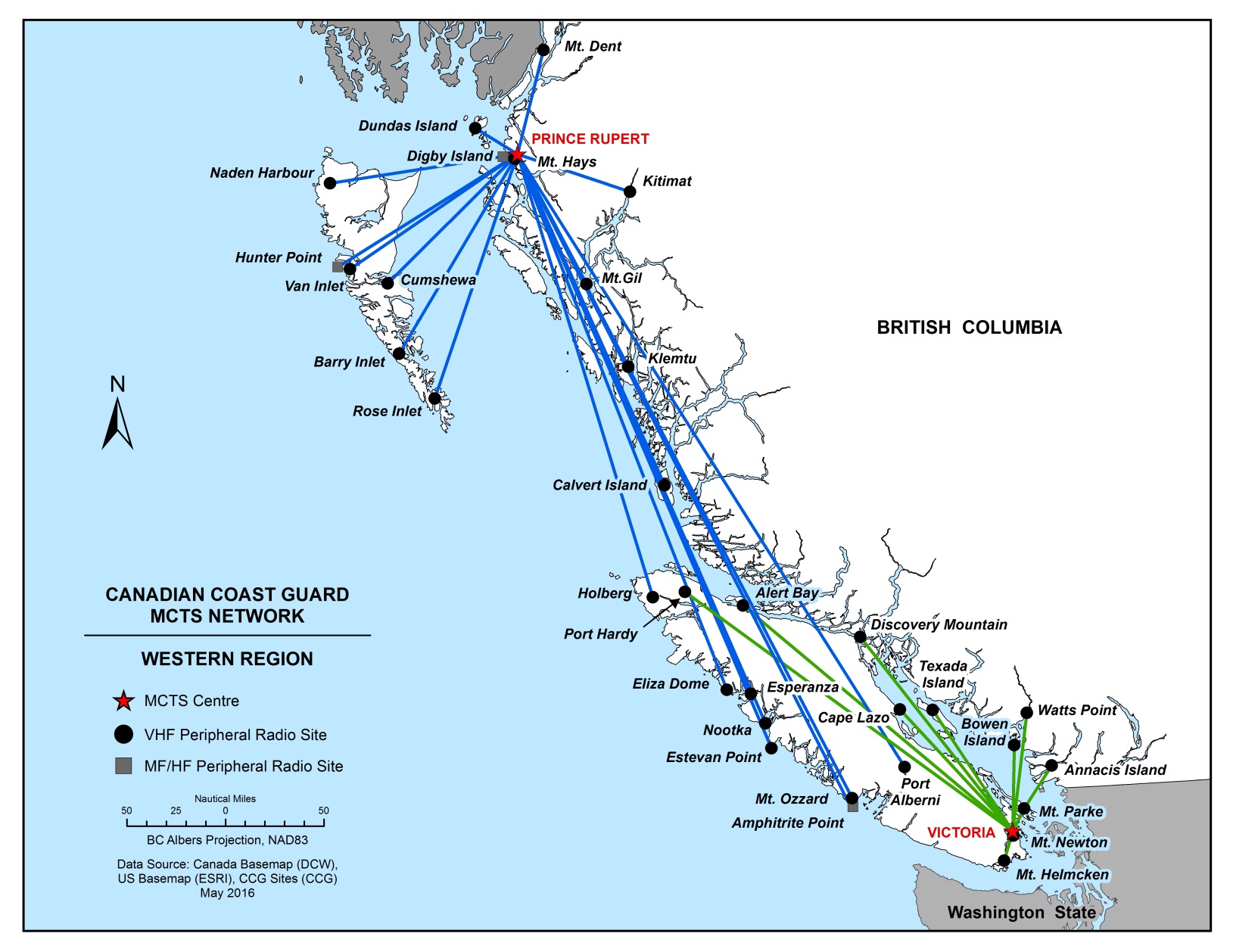
PART 2, Page 26
REMOVE Figure 2-1 – MCTS Pacific Region and replace with the following:
PART 3, Page 3
REMOVE “COMOX” from the following paragraph:
3.3.3 English Language
All communications with Seattle, Prince Rupert, Comox or Victoria Traffic must be made in clear, unbroken English. At least one person capable of conducting two-way radio communications using the English language must be present on the bridge at all times within the Co-operative VTS area. When language problems do arise, communications may be preceded by using message markers as found in the International Maritime Organisation Standard Marine Communication Phrases (SMCP).
PART 3, Page 33
AMEND the following:
3.11.2 Victoria
Table 3-8 - Sectors and Boundaries for Victoria
| Sector | Boundaries |
|---|---|
| 1 | All Canadian waters north of and included within a line from the shoreline of Vancouver Island at 48°34’58”N 124°40’00”W; southward along the meridian of longitude 124°40’00”W, to a point which intersects the International Boundary; thence following the International Boundary eastward and northward through the waters known as the Strait of Juan de Fuca, Haro Strait, Boundary Passage, and the Strait of Georgia to a point which intersects the Canadian shoreline at 49°00’00”N 123°05’20”W; thence to Roberts Bank light 49°05’16”N 123°18’31.5”W; thence to Sandheads light 49°06’23”N 123°18’04”W; thence to the Iona breakwater light 49°12’18”N 123°15’50”W; thence 270° (T) 6.6 nautical miles to 49°12’18”N 123°25 53”W; thence 000° (T) 8.15 nautical miles to Cape Roger Curtis light 49°20’24”N 123°25’53”W; thence 303° (T) 4.8 nautical miles to Gower Point 49°23’01”N 123°32’06”W; thence following the shoreline to a line joining Reception Point light 49°28’15.9”N 123°53’12”W; to Merry Island light 49°28’03.5”N 123°54’40”W; to Ballenas Island light 49°21’02”N 124°09’32”W; to Cottam Point 49°18’57”N 124°12’45”W. |
| 2 | All Canadian waters of the south or main arm of the Fraser River east of the Sandheads light 49°06’23”N 123°18’04”W; to a line running 090° (T) from Shoal Point 49°11’45”N 122°54’51”W, to the opposite south shore. |
| 3 | All Canadian waters contained north and east of a line from the Iona breakwater light, 49°12’18”N 123°15’50”W; thence 270° (T) 6.6 nautical miles to 49°12’18”N 123°25’53”W; thence 000° (T) 8.15 nautical miles to Cape Roger Curtis light 49°20’24”N 123°25’53”W; thence 303° (T) 4.8 nautical miles to Gower Point 49°23’01”N 123°32’06”W; including all the waters of Howe Sound and Burrard Inlet. |
| 4 | All Canadian waters bounded on the south by a line from Reception Point light, 49°28’15.9”N 123°53’12”W; to Merry Island light 49°28’03.5”N 123°54’40”W; to Ballenas Island light 49°21’02”N 124°09’32”W; to Cottam Point 49°18’57”N 124°12’45”W; and bounded on the north by a line from Cape Sutil 50°52'34.23"N 128°3' 7.24"W to Mexicana Point 50° 54'51.96"N 127°59'58.04"W then to Cape Caution 51°09'50"N 127°47'06"W. |
Note: Seattle and Victoria Traffic Sectors 1, 2 and 3 monitor navigation in the traffic zone using radar and AIS. Victoria Traffic Sector 4 monitors navigation in the traffic zone using AIS.
Table 3-9- Identification and Frequencies for Victoria
| Sector | Identifier | Channel | Frequency (MHz) |
|---|---|---|---|
| 1 | "Seattle Traffic" (CIP 1, 3, 5, and 8) | 05A | 156.25 |
| 1 | "Victoria Traffic" | 11 | 156.55 |
| 2 | "Victoria Traffic" | 74 | 156.725 |
| 3 | "Victoria Traffic" | 12 | 156.6 |
| 4 | "Victoria Traffic" | 71 | 156.575 |
All times shall be given in Pacific Standard Time or Pacific Daylight Saving Time whichever is in effect.
SECTION 4 - SAILING DIRECTIONS AND SMALL CRAFT GUIDE CORRECTIONS
ARC 401 — Hudson Strait, Hudson Bay and Adjoining Waters, First Edition, 2009 —
Chapter 3 — Paragraph 33, after “can find anchorage”
Insert: (not charted)
(C2016-010.01)
Chapter 3 — Paragraph 34, after “to Brewer Bay.”
Delete: “Ice has shifted … not known.”
Replace by: Its position and depth over were determined in 1998, but
mariners are cautioned that the wreck might have shifted
due to ice action, in which case its exact position and depth
over would be unknown.
(C2016-010.02)
Chapter 3 — Paragraph 35, after “Yellow Beach”
Insert: (not named on the chart)
(C2016-010.03)
Chapter 3 — Paragraph 36, after “Mooring bollards”
Insert: (not charted)
(C2016-010.04)
Chapter 3 — Paragraph 37, after “Sorry Harbour”
Delete: (not named on the chart)
SECTION 5 - LIST OF LIGHTS, BUOYS AND FOG SIGNALS CORRECTIONS
PACIFIC
| No. | Name | Position ----- Latitude N. Longitude W. |
Light Characteristics |
Focal Height in m. above water |
Nominal Range |
Description ----- Height in meters above ground |
Remarks ----- Fog Signals |
|||
|---|---|---|---|---|---|---|---|---|---|---|
| 340
G5413.16 341 G5413.17 |
Woodward Island Inbound range | 49 06 23.3
123 08 41.4 109°11’ 113.4 m from front. |
F
Fl(2) F |
Y
R Y |
.....
6s ..... |
7.6
7.9 11.7 |
10
4 10 |
Square skeleton tower, on 9-pile dolphin, red daymark, white vertical stripe.
Square skeleton tower, on 6-pile dolphin, red daymark, white vertical stripe. |
Visible in line of range.
Flash 0.5 s; eclipse 1 s; flash 0.5 s; eclipse 4 s. In operation 24 hours. Year round. In operation 24 hours. Year round. Chart:3490 Edn. 05/16 |
|
| 649
G5737 |
Trivett Point | Northern extremity of Princess Royal Island.
53 18 28.5 129 02 10.9 |
Fl | W | 4s | 6.5 | 6 | White square skeleton tower. | Year round. Chart:3944 Edn 05/16 (P16-003) |
|
| 703.3 | Kaien Island Sector | SE of the Fairview Container Terminal.
54 15 13.2
130 20 45.6 |
F | R W G | ….. | 5.8 | 7 | Square skeleton tower on a 3 pile dolphin. | Red 356.5° to 0°
Al Red/White 0° to 3°
White 3° to 5°
Al Green/White 5° to 8°
Green 8° to 11°.
Privately maintained.
Operated only on request to Prince Rupert Port Authority. Chart: 3958 Edn 05/16 (P16-042) |
|
| 712
G5801 |
Grindstone Point | On rock, N. of point.
54 18 33.7 130 23 14.4 |
Fl | R | 4s | 7.7 | 4 | White cylindrical tower, red band at top. | Year round. Chart:3955 Edn 05/16 (P16-020) |
|
| 713
G5802 |
Venn Passage | On drying rock.
54 18 42.4 130 23 35.1 |
Q | G | 1s | 6.7 | 4 | White cylindrical tower, green band at top. | Year round. Chart:3955 Edn 05/16 (P16-018) |
|
CANADIAN COAST GUARD - MARINE INFORMATION REPORT AND SUGGESTION SHEET
Name of Ship or Sender:..................................................................... Date:....................................
Address of Sender:..........................................................................................................................
Street # Street Name
Town / City:.............................. Prov / State:....................... Postal Code / Zip Code: ........................
Tel / Fax / E-mail address of sender (if appropriate):............................................................................
Observation Date:............................................. Time (UTC): ...........................................................
Geographical Position:......................................................................................................................
Coordinate Position: Lat: ............................................... Long:.........................................................
Position Method: DGPS GPS with WAAS GPS Radar Other
Horizontal Datum Used: WGS 84 NAD 27 Other
Estimated Position Accuracy:............................................................................................................
Chart #:............................................................ Datum: NAD 27 NAD 83
Chart Edition:.................................................... Last Correction applied:............................................
Publications affected: (Quote edition and page number):.....................................................................
*Full details (Attach additional sheets as necessary):...........................................................................
Mariners are requested to notify the responsible authorities when new or suspected dangers to navigation are discovered, changes are observed in aids to navigation, or corrections to publications are seen to be necessary.
In the case of new or suspected dangers to navigation, it is important that all details be given in order to aid with future investigations. Items of interest include heights, depths, physical description, type of bottom and equipment method used to position the item. It is helpful to mark details on the chart, which will be promptly replaced by the Canadian Hydrographic Service.
Reports should be made to the nearest Marine Communications and Traffic Services Centre (MCTS) and should be confirmed in writing to:
Leader, Notices to Mariners
Canadian Coast Guard
Department of Fisheries and Oceans
Montréal, QC H2Y 2E7
In the case of information concerning aids to navigation or the List of Lights, Buoys and Fog Signals book.
OR
Director General, Canadian Hydrographic Service & Oceanographic Services
Department of Fisheries and Oceans
Ottawa, ON K1A 0E6
In the case of new or suspected dangers to navigation or where corrections to "Sailing Directions" appear to be necessary.
For general questions on Canadian Coast Guard programs or services, please send an e-mail to:
info@dfo-mpo.gc.ca (Please include your postal code and e-mail address).
You can access the online form on the following page: https://www.notmar.gc.ca/incident-en.php or you can use the printable pdf version : https://www.notmar.gc.ca/publications/monthly-mensuel/images/monthly-form-en.pdf