
Archived information
The Standard on Web Usability replaces this content. This content is archived because Common Look and Feel 2.0 Standards have been rescinded.
Archived information is provided for reference, research or recordkeeping purposes. It is not subject to the Government of Canada Web Standards and has not been altered or updated since it was archived.
|
|
Fisheries and Oceans Canada |
Pêches et Ocèans Canada |
|
 |
|||
| MONTHLY EDITION N°07 July 31st, 2015 |
|||
|
CONTENTS |
|||
Page |
|||
| Section 1 |
Safety and General Information | 1 - 5 |
|
| Section 2 |
Chart Corrections | 6 - 9 |
|
| Section 3 |
Radio Aids to Marine Navigation Corrections | 10 - 15 |
|
| Section 4 |
Sailing Directions and Small Craft Guide Corrections | 16 - 17 |
|
| Section 5 |
List of Lights, Buoys and Fog signals Corrections | 18 |
|
Maritime Services Directorate Aids to Navigation |
|||
Fisheries and Oceans Canada - Official publication of the Canadian Coast Guard |
|||

Geographical positions refer directly to the graduations of the largest scale Canadian Hydrographic chart unless otherwise indicated.
Bearings refer to the true compass and are measured clockwise from 000° (North) clockwise to 359°; those relating to lights are from seaward.
Visibility of lights is that in clear weather.
Depths - The units used for soundings (metres, fathoms or feet) are stated in the title of each chart.
Elevations are normally given above Higher High Water, Large Tides unless otherwise indicated.
Distances may be calculated as follows:
1 nautical mile = 1 852 metres (6,076.1 feet)
1 statute mile = 1 609.3 metres (5,280 feet)
1 metre = 3.28 feet
Temporary & Preliminary Notices are indicated by a (T) or a (P) before the chart action and in the section 1. Please note that Nautical charts are not amended by the Canadian Hydrographic Service for Temporary (T) and Preliminary (P) Notices. It is recommended that mariners chart these corrections in pencil. Listing of charts affected by Temporary and Preliminary Notices are revised and promulgated quarterly in Section 1 of the Monthly Edition.
Please note that, in addition to the temporary and preliminary changes normally advertised as (T) and (P) Notices, there are a few permanent changes to navigational aids that have been advertised as Preliminary Notices to Mariners while charts are being updated for new editions.
Marine Information Report & Suggestion Sheet - Mariners are requested to notify the responsible authorities when new or suspected dangers to navigation are discovered, changes observed in aids to navigation or corrections to publications are seen to be necessary. Such communications can be made using the Marine Information Report & Suggestion Sheet inserted on the last page of each monthly edition of Notices to Mariners.
Canadian Hydrographic Service - Information Published in Section 2 Notices to Mariners - Mariners are advised that only the most critical changes that directly affect safety to navigation are issued in Chart Corrections - Section 2. This limitation is required to ensure that charts remain as clear and easy to read as possible. As a result, mariners may see minor discrepancies of a non-critical nature between information in official publications. For example, a small change in the nominal range or height of a light may not result in the production of a chart correction, in Notices to Mariners, but may result in a List of Light, Buoys and Fog Signals correction.
In case of discrepancy between information provided on CHS charts related to aids to navigation, and the List of Light publication, the latter shall be deemed as containing the most up to date information
Canadian Nautical Charts & Publications - A source list of Canadian Nautical Charts & Publications is
published in Notice No. 14 of the Notices to Mariners Annual Edition April 2011. The source supply and the prices
effective at the time of printing are listed. For current chart edition dates refer to the following web site:
http://www.chs-shc.gc.ca/charts-cartes/paper-papier/index-eng.asp
NOTE: Cette publication est aussi disponible en français.
Corrections to nautical charts will be listed in numeric order by chart number. Each chart correction listed applies only to that particular chart. Related charts, if any, will have their own specific correction listed separately.
Users should also refer to CHS Chart 1 Symbols, Abbreviations Terms for additional information pertaining to the correction of charts.
The illustration below describes the elements that will comprise a typical Section 2 chart correction.

The last correction number is identified with the LNM/D or Last Notice to Mariners Number / Date. This number is expressed in either old notice number format (ex.: 594/99) or in day-month-year format which is the date known as the weekly chart correction date shown in the above diagram as item (8).
MONTHLY EDITION OF NOTICES TO MARINERS WEB ACCESS
We are offering a feature where subscribers to our on-line service are able to receive the complete electronic monthly edition of
our Notices to Mariners. We are encouraging our clients to visit the web site to subscribe for this service:
http://www.notmar.gc.ca/subscribe/
Users wishing to receive information updates for their charts can do so by setting up a ’User Profile’ on the following web page http://www.notmar.gc.ca/search/mycharts-eng.php?czoxOToibnRtPXN0ZXBfb25lJmxhbmc9ZSI7
This feature permits users to register the nautical charts they currently have in their possession. Registrants are then automatically notified by e-mail when a Notice to Mariners is published concerning these charts.
ADVISORY
NOTICES TO SHIPPING (WRITTEN AND BROADCAST)
The Canadian Coast Guard is implementing a number of changes to the aids to navigation system in Canada.
These changes are advertised as Notices to Shipping (Broadcast and Written) by the Canadian Coast Guard and are followed up with Notices to Mariners, then charts are updated by hand correction, reprints or new editions.
Mariners are advised that all relevant Written Notices to Shipping should be kept until superseded by Notices to Mariners or through revised charts issued by the Canadian Hydrographic Service.
Written Notices to Shipping are available on the Canadian Coast Guard Website at: www.ccg-gcc.gc.ca/eng/CCG/NOTSHIP.
The Canadian Hydrographic Service is reviewing the impact of these changes with the Canadian Coast Guard and together we are preparing an action plan on the issuing of chart revisions.
For further information contact your local Regional Notices to Shipping (NOTSHIP) issuing authorities.
Pacific Telephone: (250) 363-6333 Email: supervisor.victoria@innav.gc.ca |
* Fisheries and Oceans Canada Telephone: (867) 979-5269 Email: IQANORDREG@INNAV.GC.CA |
* Services provided in English and French
INDEX
CANADIAN HYDROGRAPHIC SERVICE - ANNOUNCEMENT REGARDING CANADIAN HYDROGRAPHIC SERVICE CHART PATCHES. |
1 |
CANADIAN HYDROGRAPHIC SERVICE - CUMULATIVE CHART CORRECTIONS. |
1 |
CANADIAN HYDROGRAPHIC SERVICE - CURRENT CHART EDITION DATES. |
1 |
CANADIAN HYDROGRAPHIC SERVICE - PRINT ON DEMAND CHARTS - CARE AND USE. |
1 |
CANADIAN HYDROGRAPHIC SERVICE - TRANSPORT CANADA NAVIGATION SAFETY – ECDIS. |
2 |
UPDATE TO CONSOLIDATION OF MARINE COMMUNICATIONS AND TRAFFIC SERVICES (MCTS) CENTRES. |
2 |
*701 CANADIAN HYDROGRAPHIC SERVICE - NAUTICAL CHARTS. |
2 |
*702 CANADIAN HYDROGRAPHIC SERVICE - ELECTRONIC NAVIGATIONAL CHARTS. |
2 |
*703 TRANSPORT CANADA – SHIP SAFETY BULLETIN (PUBLISHED AS OF JUNE 30, 2015). |
2 |
*704 TRANSPORT CANADA – SHIP SAFETY BULLETIN. |
4 |
*705 CANADIAN COAST GUARD – LIST OF CHARTS AND REFERENCE CHARTS (SECTION 1) AFFECTED BY TEMPORARY AND PRELIMINARY NOTICES |
4 |
*706 ANNUAL EDITON NOTICES TO MARINERS 1 TO 46. UPDATE TO SECTION 7B. |
5 |
*711 CANADIAN HYDROGRAPHIC SERVICE – SAILING DIRECTIONS – PAC 206 — PACIFIC, SECOND EDITION, 2015 IS NOW AVAILABLE AS A PRINT-ON-DEMAND (POD) PRODUCT. |
5 |
*712(P) DESOLATION SOUND AND/ET SUTIL CHANNEL – UNLIGHTED BUOY TO BE DISCONTINUED. |
5 |
*714 RADIO AIDS TO MARINE NAVIGATION 2015 (PACIFIC AND ARCTIC). |
10 |
| NUMERICAL INDEX OF CANADIAN CHARTS AFFECTED. | |||||
| Chart No. | Page | Chart No. | Page | Chart No. | Page |
| 3313 | 6 | 3670 | 6 | 3959 | 7 |
| 3412 | 6 | 3795 | 2 | 3960 | 8 |
| 3419 | 6 | 3947 | 7 | 3963 | 8 |
| 3473 | 6 | 3955 | 7 | 6355 | 8 |
| 3526 | 6 | 3956 | 7 | 6356 | 8 |
| 3538 | 5 | 3957 | 7 | 6370 | 9 |
| 3647 | 6 | 3958 | 7 | 7777 | 2 |
CANADIAN HYDROGRAPHIC SERVICE - ANNOUNCEMENT REGARDING CANADIAN HYDROGRAPHIC SERVICE CHART PATCHES.
Colour Web Patches are free to the mariner, and given the quality of many printers, should reproduce well. They will be available in real time all around the world.
CHS welcomes your feedback on this service at chsinfo@dfo-mpo.gc.ca
CANADIAN HYDROGRAPHIC SERVICE - CUMULATIVE CHART CORRECTIONS.
The cumulative Notices to Mariners corrections for charts can now be accessed at
www.notmar.gc.ca/search/notmar-eng.php
CANADIAN HYDROGRAPHIC SERVICE - Current chart edition dates.
CHART EDITIONS
The three terms described below are used to indicate the publication status of Canadian charts.
NEW CHART - "NEWCHT"
The first publication of a Canadian chart embracing an area not previously charted to the scale shown, or embracing an area different from any existing Canadian chart.
NEW EDITION - "NEWEDT"
A new issue of an existing chart containing amendments essential to navigation in addition to those issued in Notices to Mariners and making existing editions obsolete.
REPRINTS
A new issue of the current edition of a chart incorporating no amendments of navigational significance other than those previously promulgated in Notices to Mariners. It may also contain amendments from other sources provided they are not essential to navigation. Previous printings of the current edition remain in force
The current chart edition dates can be accessed at www.chs-shc.gc.ca/charts-cartes/paper-papier/index-eng.asp
CANADIAN HYDROGRAPHIC SERVICE - PRINT ON DEMAND CHARTS - CARE AND USE.
Background
By providing nautical charts to the public, the goal of the Canadian Hydrographic Service (CHS) is to provide services for safe navigation in a fiscally responsible manner. As a result, CHS continues to expand its portfolio of nautical paper charts that are printed using Print On Demand (POD) technology. These charts are easily recognized by their whiter paper and the coloured logo of the Canadian Hydrographic Service. This new technology enables CHS to print charts in a more efficient manner while enhancing chart content through being able to quickly add new and important information. POD technology provides customers with up-to-date charts without the historical hand-drawn corrections or glued-on patches. Additionally, this technology eliminates out-of-stock situations which arise with the traditional printing and warehousing methods. In the event of a national emergency, CHS can respond to the appropriate authorities with best available information very quickly.
Care of Your POD Chart
CHS encourages its customers to handle the POD charts more carefully than the traditional lithographic charts. When plotting information on POD charts, use HB pencils and apply limited pressure. Testing has suggested that an Indian gum eraser is more effective than alternatives when used on the product. This eraser is also suitable for charts printed using lithographic processes.
CANADIAN HYDROGRAPHIC SERVICE - TRANSPORT CANADA NAVIGATION SAFETY - ECDIS.
Mariners are advised that ECDIS may not display some isolated shoal depths when operating in "base or standard display" mode. Route planning and monitoring alarms for these shoal depths may not always be activated. To ensure safe navigation and to confirm that a planned route is clear of such dangers, mariners should visually inspect the planned route and any deviations from it using ECDIS configured to display "all data". The automated voyage planning check function should not be solely relied upon.
UPDATE TO CONSOLIDATION OF MARINE COMMUNICATIONS AND TRAFFIC SERVICES (MCTS) CENTRES
The Canadian Coast Guard is modernizing and consolidating its Marine Communications and Traffic Services Centres. Clients will continue to receive the high-quality service they have come to expect.
Once complete, there will be a total of 12 MCTS Centres strategically located across the country. Additional information pertaining to this project will be advertised to clients by all available means.
Western Region
Comox MCTS will consolidate to Victoria MCTS in Winter/Spring 2016
The new technology will increase efficiency permitting employees to have a greater ability to focus on the safety services they provide to mariners. Mariners are encouraged to visit the Radio Aids to Marine Navigation (RAMN) http://www.ccg-gcc.gc.ca/Marine-Communications/Homeand Notices to Mariners (NOTMAR)http://www.notmar.gc.ca/ PART 3 on a monthly basis for updated information and potential changes to contact information and marine broadcast schedules.
*701 CANADIAN HYDROGRAPHIC SERVICE - NAUTICAL CHARTS.
| CHARTS | MAIN TITLE | SCALE | PUBLISHED | CAT# | PRICE |
| New Editions | |||||
| 3795 | Langley Passage, Estevan Group | 1:12000 | 02-JUN-2015 | 2 | 20.00 |
| 7777 | Coronation Gulf Western Portion/Partie Ouest | 1:150000 | 30-JUN-2015 | 4 | 20.00 |
*702 CANADIAN HYDROGRAPHIC SERVICE - ELECTRONIC NAVIGATIONAL CHART
| NEW PRODUCTS | |
| S-57 ENC NUMBER | CHART TITLE |
| CA479242 | Baie du Renard - Île d'Anticosti |
*703 TRANSPORT CANADA – SHIP SAFETY BULLETIN (PUBLISHED AS OF JUNE 30, 2015).
Ship Safety Bulletins (TP 3231) – 2015
Ship Safety Bulletins address safety-related matters pertaining to vessels. Bulletins are available from
Transport Canada’s Marine Safety Directorate free of charge and are issued on an "as needed" basis.
A complete list of Ship Safety Bulletins is available on Transport Canada’s Web site at:
http://www.tc.gc.ca/eng/marinesafety/bulletins-menu.htm
If you do not have access to our Web site and wish to be included in the Ship Safety Bulletins mailing list, please send your request to the Marine Safety location provided below. We ask your cooperation in distributing copies of this listing to your colleagues, to ship owners and/or maritime companies to let them know of the existence of these Bulletins.
If this is the first time you are receiving the Bulletin, your name is probably not on Transport Canada’s mailing list. Should you wish to be included, please send your request to the Marine Safety location provided below.
How to stay up-to-date on newly published bulletins.
To receive Ship Safety Bulletins electronically, select the following Internet address and follow the instructions
on how to sign up for e-Bulletin or RSS feed services. E-Bulletin sends a notice to your e-mail address inbox,
whereas RSS feed sends a notice to your Internet browser when a new SSB becomes available on our Internet at
http://www.tc.gc.ca/eng/marinesafety/bulletins-menu.htm.
As of June 30, 2015, the following Ship Safety Bulletins have been issued:
| Bulletin No. | Bulletin Title | Date |
| 01/2015 | Fumigation on Board Vessels | 2015-01-05 |
| 02/2015 | Why you must document how to install, secure and seal movable bulkheads to ensure their grain tightness | 2015-01-24 |
| 03/2015 | Sheltered waters voyages (amendment 2015-05-29) | 2015-04-01 |
| 04/2015 | Regulations for Vessel Air Emissions: Fuel Oil Change-Over Operations | 2015-04-30 |
| 05/2015 | Regulations for Vessel Air Emissions: Criteria of an “Identical Engine” | 2015-05-01 |
| 06/2015 | Safety of Dead Ship Towing Operations | 2015-05-13 |
| 07/2015 | Board of Steamship Inspection Renewal Project: Phase 2 | 2015-06-17 |
Transport Publications (TPs) New and/or Updated – 2015
| Publication No. | Title | Date |
| TP 8911 | Engineering Officer Education and Training Program Updated | 2015 |
| TP 14707 | Places of Refuge Contingency Plan Atlantic Region Updated | 2014 |
| TP 15287 | TERMPOL Review Process Report on the Trans Mountain Expansion Project New | 2014 |
Copies of these publications may be obtained from:
Transports Canada
Marine Safety Directorate (AMSBA)
Place de Ville, Tower “C”
330 Sparks Street, 9th floor
Ottawa, Ontario, K1A 0N5
Website: Ship Safety Bulletins: :
http://www.tc.gc.ca/marinesafety/bulletins-menu.htm
Transport Publications::
http://www.tc.gc.ca/eng/marinesafety/tp-menu-515.htm
If you have questions, or require hardcopies of Ship Safety Bulletins or Transport Publications, contact Transport Canada Marine Safety Directorate by:
Email :
marinesafety-securitemaritime@tc.gc.ca
Phone : 613-991-3135
Toll Free (Marine) : 1-866-995-9737
Teletypewriter (TTY) :1-888-675-6863
FAx : 613-990-1879
*704 TRANSPORT CANADA - SHIP SAFETY BULLETIN.
This is to notify you that a new Ship Safety Bulletin has recently been posted to the Transport Canada website at
www.tc.gc.ca/bsn-ssb/.
To go online to view or download the bulletin, please click on the links below:
Subject: Board of Steamship Inspection Renewal Project: Phase 2
Issue: SSB No.: 07/2015
Date: 2015-06-17
Link:
http://www.tc.gc.ca/eng/marinesafety/bulletins-2015-07-eng.htm
Sign yourself up for e-Bulletin to
receive an e-mail notice each time a new Ship Safety Bulletin is published on our Website.
Contact us at : marinesafety-securitemaritime@tc.gc.caor 1-855-859-3123 (Toll free)
*705 CANADIAN COAST GUARD - LIST OF CHARTS AND REFERENCE CHARTS (SECTION I) AFFECTED BY TEMPORARY AND PRELIMINARY NOTICES
IN EFFECT JUNE 26, 2015
(REVISED AND PROMULGATED QUARTERLY)
|
2017 |
909(P)/14 |
|
3490 |
1112(P)/14 213(P)/15 |
|
3538 |
712(P)/15 |
|
3546 |
714(P)/14 1113(P)/14 |
|
3668 |
1213(P)/14 |
|
4010 |
605(P)/14 709(P)/15 |
|
4201 |
509(P) /13 |
|
4236 |
609(P)/15 610(P)/15 |
|
4241 |
810(P)/14 |
|
4244 |
1006(T)/14 |
|
4279 |
1210(P)/13 |
|
4340 |
418(P)/14 |
|
4374 |
310(P)/15 311(P)/15 508(P)/15 |
|
4375 |
411(P)/15 |
|
4377 |
405(P)/13 |
|
4385 |
202(P)/15 |
|
4386 |
1108(P)/13 |
|
4396 |
507(P)/14 705(P)/14 706(P)/14 709(P)/14 |
|
4406 |
612(P)/15 |
|
4422 |
1005(P)/14 1007(P)/14 |
|
4512 |
1205(P)/13 |
|
4596 |
1209(T)/13 1003(P)/09 |
|
4830 |
1104(T) /13; |
|
4851 |
511(P)/15 |
|
4909 |
613(P)/12 810(P)/12 |
|
4911 |
510(P)/15 811(P)/12 |
|
4912 |
509(P)/15 611(P)/15 |
|
5051 |
1208(T) /13; |
|
6267 |
1114(P)/14 |
|
US14832 |
712(T)/14 |
|
US14884 |
715(T)/13 |
|
US14853 |
1211(T)/14 |
*706 ANNUAL EDITON NOTICES TO MARINERS 1 TO 46. UPDATE TO SECTION 7B.
TP 15163 (The Joint Industry-Government Guidelines for the Control of Oil Tankers and Bulk Chemical Carriers in Ice Control Zones of Eastern Canada) has been updated with Ice operation centre information and few typographical corrections.
*711 CANADIAN HYDROGRAPHIC SERVICE – SAILING DIRECTIONS – PAC 206 — PACIFIC, SECOND EDITION, 2015 IS NOW AVAILABLE AS A PRINT-ON-DEMAND (POD) PRODUCT.
Sailing Directions booklet PAC 206 — Hecate Strait, Dixon Entrance, Portland Inlet and Adjacent Waters and Haida Gwaii, Second Edition, 2015 is now available as a Print-on-Demand (POD) product. This new booklet cancels and replaces Sailing Directions, PAC 206 — Hecate Strait, Dixon Entrance, Portland Inlet and Adjacent Waters and Queen Charlotte Islands, First Edition, 2002. POD booklets are corrected through Section 4 of Notices to Mariners up to the date of printing. The price of PAC 206 — Hecate Strait, Dixon Entrance, Portland Inlet and Adjacent Waters and Haida Gwaii, Second Edition, 2015, is $19.95. Advance orders may be made through any Chart Dealer.
*712(P) DESOLATION SOUND AND/ET SUTIL CHANNEL – UNLIGHTED BUOY TO BE DISCONTINUED.
Reference Chart 3538
The Canadian Coast Guard proposes to discontinue the following aid to navigation:
Lund Spar buoy Q29, LL 5326 (49° 58’ 50.6”N 124° 45’ 45.3”W)
Comments on this action are solicited from mariners and other interested parties.
Comments should be directed to the following within three months from the date of this Notice:
Superintendent, Kevin Carrigan
Marine Navigation Services
Canadian Coast Guard
25 Huron Street, Victoria BC
V8V 4V9
Tel: 250-480-2600
Fax 250-480-2702
Email: Kevin.Carrigan@DFO-MPO-GC.CA
Any objections raised must state the facts on which they are based and should include supporting information on safety, commerce and public benefit.
(P2015-067)
CHART CORRECTIONS
| 3313 - Active Pass - Sheet/Feuille 9 - New Edition - 02-JAN-2009 - NAD 1983 | |||
| 24-JUL-2015 | LNM/D. 19-JUN-2015 | ||
| Delete | Fuel Essence |
48°51′08.0″N 123°18′12.0″W | |
| DFO(6203063-02) | |||
| 3412 - Victoria Harbour - New Edition - 22-NOV-2013 - World Geodetic System 1984 | |||
| 17-JUL-2015 | LNM/D. 30-MAY-2014 | ||
| Add | depth of 0.9 metres (See Chart No. 1, I10) |
48°25′07.0″N 123°23′13.3″W | |
| DFO(6203062-01) | |||
| Delete | depth of 1.6 metres (See Chart No. 1, I10) |
48°25′06.9″N 123°23′13.6″W | |
| DFO(6203062-02) | |||
| 3419 - Esquimalt Harbour - New Edition - 13-DEC-2013 - World Geodetic System 1984 | |||
| 24-JUL-2015 | LNM/D. 27-FEB-2015 | ||
| Add | yellow pillar buoy, marked priv (See Chart No. 1, Q23) This notice affects Electronic Navigational Chart: CA570138 |
48°26′57.6″N 123°26′55.2″W | |
| DFO(6203064-01) | |||
| 3473 - Active Pass - New Edition - 02-MAY-2003 - NAD 1983 | |||
| 24-JUL-2015 | LNM/D. 24-APR-2015 | ||
| Delete | Fuel Essence This notice affects Electronic Navigational Chart: CA570006 |
48°51′08.5″N 123°18′08.5″W | |
| DFO(6203063-01) | |||
| 3526 - Howe Sound - New Edition - 01-JUL-2005 - NAD 1983 | |||
| 24-JUL-2015 | LNM/D. 12-JUN-2015 | ||
| Add | wreck least depth known of 9.9 metres (See Chart No. 1, K26) This notice affects Electronic Navigational Chart: CA470004 |
49°26′56.8″N 123°19′49.6″W | |
| DFO(6203066-01) | |||
| 3647 - Port San Juan - New Edition - 31-DEC-2004 - NAD 1983 | |||
| 17-JUL-2015 | LNM/D. 05-JAN-2007 | ||
| Add | yellow ODAS/SADO lighted buoy Fl (5) Y 20s, marked priv (See Chart No. 1, Q58,26) This notice affects Electronic Navigational Chart: CA570184 |
48°32′11.4″N 124°29′12.0″W | |
| DFO(6203059-01) | |||
| 3670 - Broken Group - New Edition - 21-OCT-1994 - NAD 1983 | |||
| 24-JUL-2015 | LNM/D. 13-JUL-2012 | ||
| Delete | printing error Explosifs non-éclatés on certain copies | 48°53′54.5″N 125°20′13.0″W | |
| DFO(6203067-01) | |||
| 3947 - Grenville Channel to/à Chatham Sound - New Chart - 25-DEC-2009 - NAD 1983 | |||
| 24-JUL-2015 | LNM/D. 15-MAY-2015 | ||
| Add | depth of 2.2 metres (See Chart No. 1, I10) This notice affects Electronic Navigational Chart: CA470597, CA570125 |
54°12′18.5″N 130°19′25.7″W | |
| DFO(6203065-01) | |||
| 3955 - Porpoise Harbour, Ridley Island and Approaches/et les Approches - New Edition - 21-FEB-2014 - World Geodetic System 1984 | |||
| 24-JUL-2015 | LNM/D. 15-MAY-2015 | ||
| Add | depth of 2.2 metres (See Chart No. 1, I10) This notice affects Electronic Navigational Chart: CA470597, CA570125 |
54°12′18.5″N 130°19′25.7″W | |
| DFO(6203065-01) | |||
| 3955 - Venn Passage - New Edition - 21-FEB-2014 - World Geodetic System 1984 | |||
| 24-JUL-2015 | LNM/D. 15-MAY-2015 | ||
| Add | green lighted port hand pillar buoy Fl G, marked D67 (See Chart No. 1,Qg) This notice affects Electronic Navigational Chart: CA570715 |
54°20′20.6″N 130°25′45.5″W | |
| (P2015059) LL(718.5) DFO(6203056-01) | |||
| Delete | red spar buoy, marked priv (See Chart No. 1, Q24) This notice affects Electronic Navigational Chart: CA570715 |
54°20′21.5″N 130°25′46.5″W | |
| DFO(6203056-02) | |||
| 3956 - Malacca Passage to/à Bell Passage - New Edition - 01-MAR-1996 - NAD 1983 | |||
| 24-JUL-2015 | LNM/D. 12-JUN-2015 | ||
| Add | depth of 2.2 metres (See Chart No. 1, I10) This notice affects Electronic Navigational Chart: CA470597, CA570125 |
54°12′18.5″N 130°19′25.7″W | |
| DFO(6203065-01) | |||
| 3957 - Approaches to/Approches à Prince Rupert Harbour - New Edition - 05-JUN-1998 - NAD 1983 | |||
| 24-JUL-2015 | LNM/D. 12-JUN-2015 | ||
| Add | depth of 2.2 metres (See Chart No. 1, I10) This notice affects Electronic Navigational Chart: CA470597, CA570125 |
54°12′18.5″N 130°19′25.7″W | |
| DFO(6203065-01) | |||
| 3958 - Prince Rupert Harbour - New Edition - 13-DEC-2013 - World Geodetic System 1984 | |||
| 24-JUL-2015 | LNM/D. 12-JUN-2015 | ||
| Add | depth of 2.2 metres (See Chart No. 1, I10) This notice affects Electronic Navigational Chart: CA470597, CA570125 |
54°12′18.5″N 130°19′25.7″W | |
| DFO(6203065-01) | |||
| 3959 - Hudson Bay Passage - New Chart - 11-DEC-1987 - NAD 1983 | |||
| 17-JUL-2015 | LNM/D. 26-JUN-2015 | ||
| Add | red, green and red starboard bifurcation lighted pillar buoy Fl(2+1)R, marked DF (See Chart No. 1 Qi) This notice affects Electronic Navigational Chart: CA470364 |
54°33′50.7″N 130°26′38.0″W | |
| (P2015060) LL(726.1) DFO(6203057-01) | |||
| 3960 - Approaches to/Approches à Portland Inlet - New Chart - 13-AUG-1993 - NAD 1983 | |||
| 17-JUL-2015 | LNM/D. 26-JUN-2015 | ||
| Add | red, green and red starboard bifurcation lighted pillar buoy Fl(2+1)R, marked DF (See Chart No. 1 Qi) This notice affects Electronic Navigational Chart: CA470364 |
54°33′50.7″N 130°26′38.0″W | |
| (P2015060) LL(726.1) DFO(6203057-01) | |||
| 3963 - Work Channel A-B - New Chart - 26-OCT-1990 - NAD 1983 | |||
| 17-JUL-2015 | LNM/D. 26-JUN-2015 | ||
| Add | red, green and red starboard bifurcation lighted pillar buoy Fl(2+1)R, marked DF (See Chart No. 1 Qi) This notice affects Electronic Navigational Chart: CA470364 |
54°33′50.7″N 130°26′38.0″W | |
| (P2015060) LL(726.1) DFO(6203057-01) | |||
| 6355 - Mirage Point to/à Hardisty Island - Sheet/Feuille 1 - New Edition - 27-MAY-2005 - NAD 1983 | |||
| 03-JUL-2015 | LNM/D. 24-APR-2015 | ||
| Delete | depth of 17 feet (See Chart No. 1, I10) |
61°46′15.0″N 114°36′51.0″W | |
| DFO(6604107-01) | |||
| Add | obstruction, depth unknown, Rep (2015) (See Chart No. 1, K40, I3.2) |
61°46′14.0″N 114°36′53.0″W | |
| DFO(6604107-02) | |||
| Add | obstruction, depth unknown, Rep (2015) (See Chart No. 1, K40, I3.2) |
61°46′23.0″N 114°36′45.0″W | |
| DFO(6604107-03) | |||
| 6356 - Hardisty Island to/à North Head - Sheet/Feuille 1 - New Edition - 27-MAY-2005 - NAD 1983 | |||
| 03-JUL-2015 | LNM/D. 24-APR-2015 | ||
| Delete | depth of 17 feet (See Chart No. 1, I10) |
61°46′15.0″N 114°36′51.0″W | |
| DFO(6604107-01) | |||
| Add | obstruction, depth unknown Rep (2015) (See Chart No. 1, K40, I3.2) |
61°46′14.0″N 114°36′53.0″W | |
| DFO(6604107-02) | |||
| Add | obstruction, depth unknown, Rep (2015) (See Chart No. 1, K40, I3.2) |
61°46′23.0″N 114°36′45.0″W | |
| DFO(6604107-03) | |||
| Add | obstruction, depth unknown, Rep (2015) (See Chart No. 1, K40, I3.2) |
61°42′29.0″N 114°52′26.0″W | |
| DFO(6604107-04) | |||
| Add | obstruction, depth unknown, Rep (2015) (See Chart No. 1, K40) |
61°42′42.0″N 114°51′34.0″W | |
| DFO(6604107-05) | |||
| 6370 - Great Slave Lake / Grand lac des Esclaves, Western Portion / Partie ouest - Sheet/Feuille 1 - New Edition - 03-AUG-1990 - Astronomic Positioning | |||
| 03-JUL-2015 | LNM/D. 07-FEB-2014 | ||
| Delete | depth of 3.4 metres (See Chart No. 1, I10) |
61°46′15.0″N 114°36′00.0″W | |
| DFO(6604107-01) | |||
| Add | obstruction, depth unknown, Rep (2015) (See Chart No. 1, K40, I3.2) |
61°46′15.4″N 114°36′42.8″W | |
| DFO(6604107-02) | |||
| Add | obstruction, depth unknown, Rep (2015) (See Chart No. 1, K40, I3.2) |
61°42′23.4″N 114°52′15.8″W | |
| DFO(6604107-04) | |||
| Add | obstruction, depth unknown, Rep (2015) (See Chart No. 1, K40) |
61°42′43.4″N 114°51′23.8″W | |
| DFO(6604107-05) | |||
CORRECTIONS TO RADIO AIDS TO MARINE NAVIGATION
*714 RADIO AIDS TO MARINE NAVIGATION 2015 (PACIFIC AND ARCTIC).
PART 1 - Page 8
AMEND
1.7 REGIONAL NOTICES TO SHIPPING (NOTSHIP) ISSUING AUTHORITIES
Fisheries and Oceans Canada
Canadian Coast Guard
Vancouver MCTS Centre
Suite 2380
555, West Hastings Street
Vancouver (BC) V6B 4N6
Telephone: 604-666-6011
Facsimile: 604-666-8453
Email: offshore@rmic.gc.ca
TO READ:
Fisheries and Oceans Canada
Canadian Coast Guard
Victoria MCTS Centre
Institute of Ocean Sciences
9860 West Saanich Road
PO Box 6000
Sidney (BC) V8L 4B2
Telephone: 250-363-6333
Facsimile: 250-363-6556
Email: supervisor.Victoria@innav.gc.ca
PART 2 – Page 13
AMEND:
Telephone:
250-627-3074 MCTS Operations/Supervisor
250-627-3077 Officer-in-Charge
250-624-9009 Continuous Marine Broadcast (CMB)
250-627-3081 Maritime Emergency/ Safety – North
250-627-3082 Maritime Emergency/ Safety - South
TO READ:
Téléphone:
250-627-3074 MCTS Operations/Supervisor
250-627-3077 Officer in Charge
250-624-9009 Continuous Marine Broadcast (CMB North)
250-726-3415 Continuous Marine Broadcast (CMB South)
250-627-3081 Maritime Emergency/ Safety – North
250-627-3082 Maritime Emergency/ Safety - South
PART 3 – Page 14
AMEND:
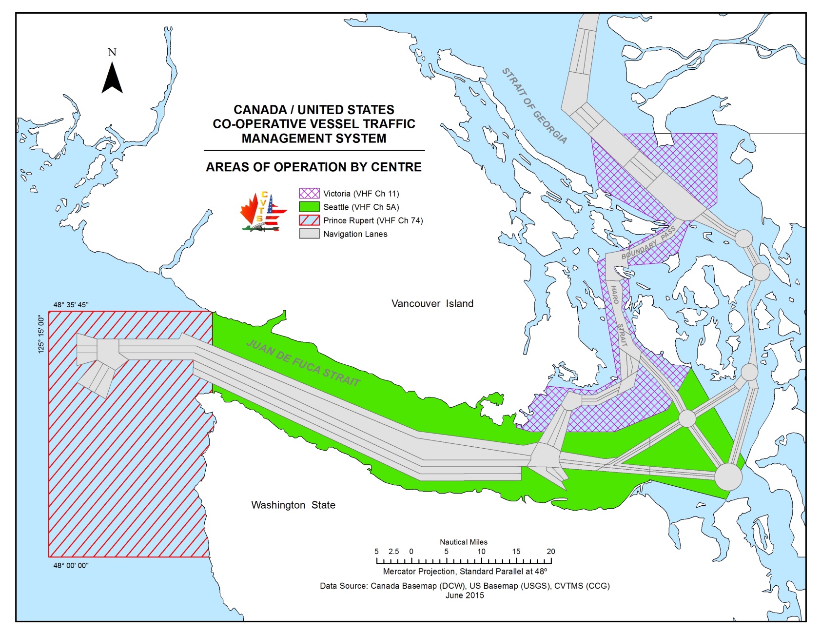
3.8.1 Co-Operative Vessel Traffic Services (CVTS)
Participation with Tofino, Seattle and Victoria Traffic is mandatory within Canadian and United States territorial waters. The CVTS Area of Operation is defined as 124°40W south along the Washington coast to 48°00N then west to 125°15W and north to 48°35’45”N. Inbound vessels are to check in with Tofino Traffic on VHF Channel 74 (156.725 MHz) at either 48°00N or 125°15W prior to entering the traffic separation scheme. An information service such as a vessel’s identity, destination, or other information obtained through the VTS reports and sensors, is available upon request outside of the VTS zone.
TO READ:
Participation with Prince Rupert, Seattle and Victoria Traffic is mandatory within Canadian and United States territorial waters. The CVTS Area of Operation is defined as 124°40W south along the Washington coast to 48°00N then west to 125°15W and north to 48°35’45”N. Inbound vessels are to check in with Prince Rupert Traffic on VHF Channel 74 (156.725 MHz) at either 48°00N or 125°15W prior to entering the traffic separation scheme. An information service such as a vessel’s identity, destination, or other information obtained through the VTS reports and sensors, is available upon request outside of the VTS zone.
PART 3 - Page 15
AMEND:
3.8.2 Tofino Trafic
West Coast Approaches to Juan de Fuca Strait
Vessel Traffic Services from 124°40’00W in Juan de Fuca Strait westward to 125°15’00”W, and intersecting to the south to 48°00N from the west coast of Washington State are provided by the Canadian Coast Guard from the Tofino MCTS Centre at Amphitrite Point, BC (Tofino Traffic).
All communications with vessels in these areas will be conducted on VHF Ch 74 (156.725 MHz).
TO READ:
3.82.2 Prince Rupert Trafic
West Coast Approaches to Juan de Fuca Strait.
Vessel Traffic Services from 124°40’00W in Juan de Fuca Strait westward to 125°15’00”W, and intersecting to the south to 48°00N from the west coast of Washington State are provided by the Canadian Coast Guard from the Prince Rupert MCTS Centre located in Prince Rupert, BC.
All communications with vessels in these areas will be conducted on VHF Ch 74 (156.725 MHz).
PART 3 - Page 18
REMOVE Figure 3-1 Canada/United States Co-operative Vessel Traffic Management System
REPLACE with:

PART 3 - Page 34
AMEND:
Table 3-10 - Calling-In-Points for Victoria
| Number | Sector | Name | General Description and Conditions | Geographic Description |
| 1 | Change | Zone Limit | A line running north along the meridian 124 40 00W from the International Boundary to the Vancouver Island shoreline. Administered by Seattle and Tofino Traffic (CVTS). | A line running north from 48°28’36”N 124°40’00”W to 48°34’58”N 124°40’00”W. |
| Number | Sector | Name | General Description and Conditions | Geographic Description |
| 1 | Change | Zone Limit | A line running north along the meridian 124 40 00W from the International Boundary to the Vancouver Island shoreline. Administered by Seattle and Prince Rupert Traffic (CVTS). | A line running north from 48°28’36”N 124°40’00”W to 48°34’58”N 124°40’00”W. |
PART 4 - Page 45
AMEND
4.2.9 Pre-Arrival Information Report (PAIR)
a) Vessels planning to enter Canadian waters inbound to a Canadian port on the West Coast shall send pre-arrival information to the Canadian Coast Guard Regional Marine Information Centre (RMIC) via one of the following methods listed below:
Email: offshore@rmic.gc.ca
Inmarsat: telex 04352586
"CGTC VAS VCR” any Canadian Coast Guard MCTS Centre,
free of charge; or directly to CVTS Offshore by
Facsimile: 604-666-8453
TO READ :
a) Vessels planning to enter Canadian waters inbound to a Canadian port on the West Coast shall send pre-arrival information to Transport Canada Marine Security Operations Centre:
Email: marsecw@tc.gc.ca
PART 4 – Page 50
REMOVE Figure 4-8 – NAVTEX Coverage Western Region
REPLACE with:
PART 4 - Page 65
REMOVE completely:
Ucluelet, British Columbia V0R 3A0
Supervisor of Technical Maintenance
Fisheries and Oceans Canada
Canadian Coast Guard
Canadian Coast Guard Ships Electronic Workshop
PO Box 190
Telephone: 250-726-4335
Facsimile: 250-726-7234
Table of Contents :
Change title of 3.8.2 to “Prince Rupert Traffic”
SAILING DIRECTIONS AND SAMLL CRAFT GUIDE CORRECTIONS
PAC 201 — Juan de Fuca Strait and Strait of Georgia, First Edition, 2012
Chapter 2 — Paragraph 37, last line
Add: A drying rock with 1.7 m over it, close east of Paterson Point, is marked by a private buoy.
(P2015-15.1)
Chapter 5 — After paragraph 322
Insert: 322.1 HMCS Annapolis was sunk in 2015 on the west side of the entrance to Halkett Bay as an
artificial reef for divers. This vessel was a Royal Canadian Navy Destroyer Escort, 113 m long.
It is marked by buoys and has a least depth of 9.9 m. For more information see www.artificialreef.bc.ca.
(P2015-16.1)
Chapter 5 — Adjacent to paragraph 322.1, add a caution pictograph.
(P2015-16.2)
Chapter 6 — Paragraph 468
Delete: Docks are on the north side, one for seaplanes, the other is a fuel dock.
Replace by: The dock on the north side is for seaplanes only.
(P2015-12.1)
PAC 205 — Inner Passage — Queen Charlotte Sound to Chatham Sound, First Edition, 2002 —
Chapter 3 — Paragraph 354
Delete: “A private red buoy … “Village of Metlakatla”.”
Replace by: A port hand light buoy “D67” (718.5) is positioned NE of the Carolina Islands.
(P2015-14.1)
Chapter 3 — Delete paragraph 503
Replace by: 503 The fairway through Dodd Passage is marked by starboard hand buoy “D88”, port hand buoy “D89”
and starboard bifurcation light buoy “DF” (726.1).
(P2015-13.1)
Chapter 3 — Delete paragraph 514
Replace by: 514 Lax Kw’alaams port hand light buoy “D91” (727), about 0.1 mile NNE of the breakwater light,
marks the outer edge of a shoal ledge.
(P2015-11.1)
PAC 206 — Hecate Strait, Dixon Entrance, Portland Inlet and Adjacent Waters and Queen Charlotte Islands, First Edition, 2002 —
Chapter 1 — Delete paragraph 310
Replace by: 310 Kitkatla Boat Harbour port hand light buoy “E95” (745.5) marks the NW extremity of a
drying ledge extending about 0.15 mile off Kitkatla.
(P2015-10.1)
Chapter 2 — Paragraph 280
Delete: Starboard hand buoy “C40”
Replace by: Stubbs Rock starboard hand light buoy “C40” (795.5)
(P2015-10.2)
Chapter 2 — Paragraph 290
Delete: A starboard hand daybeacon
Replace by: Port Clements breakwater light (795.3)
(P2015-10.3)
Chapter 2 — Adjacent to paragraph 290, add a light pictograph.
(P2015-10.4)
LIST OF LIGHTS, BUOYS AND FOG SIGNALS CORRECTIONS
Pacifique |
||||||||||
403 G5448 |
Burnaby Shoal |
On shoal. 49 17 54.4 123 06 38.4 |
Q |
R |
1s |
9.8 |
10 |
White cylindrical tower, red band at top. |
Chart:3493 Edn. 07/15(P15-063) |
|
478.2 G5567.4 |
Lund Breakwater South |
49 58 47.8 124 45 50.8 |
Fl |
Y |
4s |
2.1 |
2 |
Mast. |
Chart:3538 Edn. 07/15 (P15-056) |
|
478.3 G5567.5 |
Lund Breakwater Centre |
49 58 49.4 124 45 51.8 |
Fl |
Y |
4s |
2.1 |
2 |
Mast. |
Chart:3538 Edn. 07/15 (P15-057) |
|
478.4 |
Lund Breakwater North |
49 58 52.3 124 45 52.0 |
Q |
R |
1s |
2.0 |
3 |
Mast, red and white triangular daymark. |
Chart:3538 Edn. 07/15 (P15-058) |
|
718.5 |
Metlakatla, entrance light buoy D67 |
54 20 20.6 130 25 45.5 |
Fl |
G |
4s |
..... |
..... |
Green, marked "D67". |
Chart:3955 Edn. 07/15(P15-059) |
|
726.1 |
Rose Island Passage Bifurcation - light buoy DF |
54 33 50.7 130 26 38.0 |
Fl(2+1) |
R |
6s |
..... |
..... |
Red, green, red, marked "DF". |
Flash 0.3 s; eclipse 0.4 s. Flash 0.3 s; eclipse 1.2 s. Flash 0.3 s; eclipse 3.5 s. Chart:3963 Edn. 07/15 (P15-060) |
|
Name of Ship or Sender:..................................................................... Date:....................................
Address of Sender:..........................................................................................................................
Street # Street Name
Town / City:.............................. Prov / State:....................... Postal Code / Zip Code: ........................
Tel / Fax / E-mail address of sender (if appropriate):............................................................................
Observation Date:............................................. Time (UTC): ...........................................................
Geographical Position:......................................................................................................................
Coordinate Position: Lat: ............................................... Long:.........................................................
Position Method: q DGPS q GPS with WAAS q GPS q Radar qOther
Horizontal Datum Used: qWGS 84 q NAD 27 q Other
Estimated Position Accuracy:............................................................................................................
Chart #:............................................................ Datum: q NAD 27 q NAD 83
Chart Edition:.................................................... Last Correction applied:............................................
Publications affected: (Quote Volume and page):.................................................................................
*Full details (Attach additional sheets as necessary)............................................................................
Mariners are requested to notify the responsible authorities when new or suspected dangers to navigation are discovered, changes are observed in aids to navigation, or corrections to publications are seen to be necessary.
In the case of new or suspected dangers to navigation, it is important that all details be given in order to aid with future investigations. Items of interest include heights, depths, physical description, type of bottom and equipment method used to position the item. It is helpful to mark details on chart, which will be promptly replaced by the Canadian Hydrographic Service.
Reports should be made to the nearest Marine Communications and Traffic Services Centre (MCTS) and should be confirmed in writing to:
|
Leader, Notices to Mariners Canadian Coast Guard Department of Fisheries and Oceans Mountréal, Qc H2Y 2E7 |
In the case of information concerning aids to navigation or the List of Lights, Buoys and Fog Signals. |
|
OR |
|
Dominion Hydrographer Canadian Hydrographic Service Department of Fisheries and Oceans Ottawa, Ontario, K1A 0E6 |
In the case of new or suspected dangers to navigation or where corrections to "Sailing Directions" appear to be necessary. |
Or general questions on Coast Guard programs or services please send an e-mail message to:
info@dfo-mpo.gc.ca (Please include your postal code and e-mail address).