
Archived information
The Standard on Web Usability replaces this content. This content is archived because Common Look and Feel 2.0 Standards have been rescinded.
Archived information is provided for reference, research or recordkeeping purposes. It is not subject to the Government of Canada Web Standards and has not been altered or updated since it was archived.
|
| Fisheries and Oceans Canada |
Pêches et Océans Canada |
|
 |
|||
| VOL. 38, MONTHLY EDITION N °06 June 28, 2013 Publication Number 40063779 |
|||
|
CONTENTS |
|||
Page |
|||
| Section 1 |
Safety and General Information | 1 to 4 |
|
| Section 2 |
Chart Corrections | 5 to 16 |
|
| Section 3 |
Radio Aids to Marine Navigation Corrections | 17 |
|
| Section 4 |
Sailing Directions and Small Craft Guide Corrections | 18 |
|
| Section 5 |
List of Lights, Buoys and Fog signals Corrections | 19,20 |
|
Maritime Services Directorate Aids to Navigation |
|||
Fisheries and Oceans Canada - Official publication of the Canadian Coast Guard |
|||

EXPLANATORY NOTES |
Geographical positions refer directly to the graduations of the largest scale Canadian Hydrographic chart unless otherwise indicated. |
Bearings refer to the true compass and are measured clockwise from 000° (North) clockwise to 359°; those relating to lights are from seaward. |
Visibility of lights is that in clear weather. |
Depths - The units used for soundings (metres, fathoms or feet) are stated in the title of each chart. |
Elevations are normally given above Higher High Water, Large Tides unless otherwise indicated. |
Distances may be calculated as follows: |
1 nautical mile = 1 852 metres (6,076.1 feet) 1 statute mile = 1 609.3 metres (5,280 feet) 1 metre = 3.28 feet |
Temporary & Preliminary Notices are indicated by a (T) or a (P) before the chart action and in the section 1. Please note that Nautical charts are not amended by the Canadian Hydrographic Service for Temporary (T) and Preliminary (P) Notices. It is recommended that mariners chart these corrections in pencil. Listing of charts affected by Temporary and Preliminary Notices are revised and promulgated quarterly in Section 1 of the Monthly Edition . |
Please note that, in addition to the temporary and preliminary changes normally advertised as (T) and (P) Notices, there are a few permanent changes to navigational aids that have been advertised as Preliminary Notices to Mariners while charts are being updated for new editions. |
Marine Information Report & Suggestion Sheet - Mariners are requested to notify the responsible authorities when new or suspected dangers to navigation are discovered, changes observed in aids to navigation or corrections to publications are seen to be necessary. Such communications can be made using the Marine Information Report & Suggestion Sheet inserted on the last page of each monthly edition of Notices to Mariners. |
Canadian Hydrographic Service – Information Published in Section 2 Notices to Mariners - Mariners are advised that only the most critical changes that directly affect safety to navigation are issued in Chart Corrections - Section 2. This limitation is required to ensure that charts remain as clear and easy to read as possible. As a result, mariners may see minor discrepancies of a non-critical nature between information in official publications. For example, a small change in the nominal range or height of a light may not result in the production of a chart correction, in Notices to Mariners, but may result in a List of Light, Buoys and Fog Signals correction. |
| In case of discrepancy between information provided on CHS charts related to aids to navigation, and the List of Light publication, the latter shall be deemed as containing the most up to date information |
Canadian Nautical Charts & Publications - A source list of Canadian Nautical Charts & Publications is published in Notice No. 14 of the Notices to Mariners Annual Edition April 2011. The source supply and the prices effective at the time of printing are listed. For current chart edition dates refer to the following web site: http://www.chs-shc.gc.ca/charts-cartes/paper-papier/index-eng.asp |
NOTE: Cette publication est aussi disponible en français. |
CHART CORRECTIONS - SECTION 2 |
|
Corrections to nautical charts will be listed in numeric order by chart number. Each chart correction listed applies only to that particular chart. Related charts, if any, will have their own specific correction listed separately. Users should also refer to CHS Chart 1 Symbols, Abbreviations Terms for additional information pertaining to the correction of charts. The illustration below describes the elements that will comprise a typical Section 2 chart correction. |

ADVISORY |
|
NOTICES TO SHIPPING (WRITTEN AND BROADCAST) |
|
The Canadian Coast Guard is implementing a number of changes to the aids to navigation system in Canada . |
|
These changes are advertised as Notices to Shipping (Broadcast and Written) by the Canadian Coast Guard and are followed up with Notices to Mariners, then charts are updated by hand correction, reprints or new editions. |
|
Mariners are advised that all relevant Written Notices to Shipping should be kept until superseded by Notices to Mariners or through revised charts issued by the Canadian Hydrographic Service. |
|
Written Notices to Shipping are available on the Canadian Coast Guard Website at: www.ccg-gcc.gc.ca/eng/CCG/NOTSHIP. |
|
The Canadian Hydrographic Service is reviewing the impact of these changes with the Canadian Coast Guard and together we are preparing an action plan on the issuing of chart revisions. |
|
For further information contact your local Regional Notices to Shipping (NOTSHIP) issuing authorities. |
Pacific Telephone: (604) 666-6011 RMIC Email: rmic-pacific@pac.dfo-mpo.gc.ca * Services provided in English and French |
|
* Fisheries and Oceans Canada Telephone: (867) 979-5269 Email: IQANORDREG@INNAV.GC.CA |
|
MONTHLY EDITION OF NOTICES TO MARINERS |
WEB ACCESS |
We are offering a feature where subscribers to our on-line service are able to receive the complete electronic monthly edition of our Notices to Mariners. We are encouraging our clients to visit the http://www.notmar.gc.ca/subscribe/ web site to subscribe for this service. Users wishing to receive information updates for their charts can do so by setting up a 'User Profile' on the following web page http://www.notmar.gc.ca/search/mycharts-eng.php?czoxOToibnRtPXN0ZXBfb25lJmxhbmc9ZSI7 This feature permits users to register the nautical charts they currently have in their possession. Registrants are then automatically notified by e-mail when a Notice to Mariners is published concerning these charts. |
|
INDEX |
CANADIAN HYDROGRAPHIC SERVICE - ANNOUNCEMENT REGARDING CANADIAN HYDROGRAPHIC SERVICE CHART PATCHES. 1
CANADIAN HYDROGRAPHIC SERVICE - CUMULATIVE CHART CORRECTIONS. 1
CANADIAN HYDROGRAPHIC SERVICE - CURRENT CHART EDITION DATES. 1
CANADIAN HYDROGRAPHIC SERVICE - PRINT ON DEMAND CHARTS - CARE AND USE. 1
CANADIAN HYDROGRAPHIC SERVICE - TRANSPORT CANADA NAVIGATION SAFETY - ECDIS. 1
*601 CANADIAN HYDROGRAPHIC SERVICE - NAUTICAL CHARTS. 2
*602 CANADIAN HYDROGRAPHIC SERVICE - ELECTRONIC NAVIGATIONAL CHARTS. 2
*603 CANADIAN HYDROGRAPHIC SERVICE - RASTER DIGITAL CHARTS (BSB V4). 3
*604 CANADIAN HYDROGRAPHIC SERVICE - MARINE COMMUNICATION AND TRAFIC SERVICES - SAILING DIRECTION - 101 - NEWFOUNDLAND - NORTHEAST AND EAST COASTS, SECOND EDITION, 2013 IS NOW AVAILABLE AS A PRINT-ON-DEMAND (POD) PRODUCT. 3
*605 CANADIAN COAST GUARD - OPEN INFORMATION LICENCE FOR NAUTICAL PUBLICATIONS. 3
*606 CANADIAN COAST GUARD PUBLICATION - AMENDMENT TO THE ANNUAL EDITON OF NOTICES TO MARINERS - APRIL 2013 TO MARCH 2014 - NOTICE B24 - NAVIGATION SAFETY REGULATIONS. 4
*607 METAAREAS MARINE FORECAST PROGRAM: MODIFICATIONS TO THE PRESENTATION OF THE VISIBILITY FORECAST FOR THE 2013 ARCTIC SHIPPING SEASON. 4
*614 CINNEMOUSUN NARROWS - SHEET 2 - BARGES REMOVED. 4
*615 CANADIAN COAST GUARD PUBLICATION - RADIO AIDS TO MARINE NAVIGATION (PACIFIC AND WESTERN ARCTIC) PUBLICATION - 2013 - FACILITY INFORMATION AMENDMENT. 17
|
NUMERICAL INDEX OF CANADIAN CHARTS AFFECTED |
|||||
|
Chart No. |
Page |
Chart No. |
Page |
Chart No. |
Page |
|
1236 |
2 |
|
|
|
|
|
1438 |
2 |
|
|
|
|
|
3053 |
4 |
|
|
|
|
|
3313 |
5, 6 |
|
|
|
|
|
3443 |
6-8 |
|
|
|
|
|
3456 |
8-10 |
|
|
|
|
|
3458 |
10, 11 |
|
|
|
|
|
3459 |
11, 12 |
|
|
|
|
|
3463 |
12 |
|
|
|
|
|
3575 |
12 |
|
|
|
|
|
3490 |
2, 12 |
|
|
|
|
|
3491 |
2 |
|
|
|
|
|
3494 |
2 |
|
|
|
|
|
3495 |
2 |
|
|
|
|
|
3512 |
13 |
|
|
|
|
|
3548 |
13 |
|
|
|
|
|
3668 |
13 |
|
|
|
|
|
3724 |
14 |
|
|
|
|
|
3742 |
14, 15 |
|
|
|
|
|
3912 |
15 |
|
|
|
|
|
3920 |
15, 16 |
|
|
|
|
|
4142 |
2 |
|
|
|
|
|
4452 |
2 |
|
|
|
|
|
5048 |
2 |
|
|
|
|
|
6206 |
16 |
|
|
|
|
SECTION 1
SAFETY AND GENERAL INFORMATION
CANADIAN HYDROGRAPHIC SERVICE - ANNOUNCEMENT REGARDING CANADIAN HYDROGRAPHIC SERVICE CHART PATCHES
Colour Web Patches are free to the mariner, and given the quality of many printers, should reproduce well. They will be available in real time all around the world.
CHS welcomes your feedback on this service at chsinfo@dfo-mpo.gc.ca
CANADIAN HYDROGRAPHIC SERVICE - CUMULATIVE CHART CORRECTIONS
The cumulative Notices to Mariners corrections for charts can now be accessed at
www.notmar.gc.ca/search/notmar-eng.php
CANADIAN HYDROGRAPHIC SERVICE - CURRENT CHART EDITION DATES
|
CHART EDITIONS |
|
The three terms described below are used to indicate the publication status of Canadian charts. |
|
NEW CHART - "NEWCHT" |
|
The first publication of a Canadian chart embracing an area not previously charted to the scale shown, or embracing an area different from any existing Canadian chart. |
|
NEW EDITION - "NEWEDT" |
|
A new issue of an existing chart containing amendments essential to navigation in addition to those issued in Notices to Mariners and making existing editions obsolete. |
|
REPRINTS |
|
A new issue of the current edition of a chart incorporating no amendments of navigational significance other than those previously promulgated in Notices to Mariners. It may also contain amendments from other sources provided they are not essential to navigation. Previous printings of the current edition remain in force. |
The current chart edition dates can be accessed at www.chs-shc.gc.ca/charts-cartes/paper-papier/index-eng.asp
CANADIAN HYDROGRAPHIC SERVICE - PRINT ON DEMAND CHARTS - CARE AND USE
|
Background
By providing nautical charts to the public, the goal of the Canadian Hydrographic Service (CHS) is to provide services for safe navigation in a fiscally responsible manner. As a result, CHS continues to expand its portfolio of nautical paper charts that are printed using Print On Demand (POD) technology. These charts are easily recognized by their whiter paper and the coloured logo of the Canadian Hydrographic Service. This new technology enables CHS to print charts in a more efficient manner while enhancing chart content through being able to quickly add new and important information. POD technology provides customers with up-to-date charts without the historical hand-drawn corrections or glued-on patches. Additionally, this technology eliminates out-of-stock situations which arise with the traditional printing and warehousing methods. In the event of a national emergency, CHS can respond to the appropriate authorities with best available information very quickly.
Care of Your POD Chart
CHS encourages its customers to handle the POD charts more carefully than the traditional lithographic charts. When plotting information on POD charts, use HB pencils and apply limited pressure. Testing has suggested that an Indian gum eraser is more effective than alternatives when used on the product. This eraser is also suitable for charts printed using lithographic processes. |
CANADIAN HYDROGRAPHIC SERVICE - TRANSPORT CANADA NAVIGATION SAFETY - ECDIS
|
Mariners are advised that ECDIS may not display some isolated shoal depths when operating in "base or standard display" mode. Route planning and monitoring alarms for these shoal depths may not always be activated. To ensure safe navigation and to confirm that a planned route is clear of such dangers, mariners should visually inspect the planned route and any deviations from it using ECDIS configured to display "all data". The automated voyage planning check function should not be solely relied upon. |
*601 CANADIAN HYDROGRAPHIC SERVICE - NAUTICAL CHARTS
|
CHARTS |
MAIN TITLE |
SCALE |
PUBLISHED |
CAT# |
PRICE |
|
New Charts |
|
||||
|
3981 |
Laredo Channel and/et Laredo Inlet |
1:40000 |
19-APR-2013 |
|
|
|
New Editions |
All temporary and preliminary notices affecting the previous versions of the following chart(s) (is / are) now cancelled. For any outstanding notices please consult section 2 of this edition. |
||||
|
1236 |
Pointe des Monts aux/to Escoumins |
1:200000 |
26-OCT-2012 |
1 |
20.00 |
|
1438 |
Grindstone Island to/à Carleton Island |
1:25000 |
31-AUG-2012 |
3 |
20.00 |
|
3490 |
Fraser River/Fleuve Fraser, Sand Heads to/à Douglas Island |
1:20000 |
02-NOV-2012 |
2 |
20.00 |
|
3491 |
Fraser River/Fleuve Fraser, North Arm |
1:20000 |
19-OCT-2012 |
2 |
20.00 |
|
3494 |
Vancouver Harbour Central Portion/Partie Centrale |
1:10000 |
16-NOV-2012 |
2 |
20.00 |
|
3495 |
Vancouver Harbour Eastern Portion/Partie Est |
1:30000 |
14-DEC-2012 |
2 |
20.00 |
|
4452 |
Havres et Mouillages - Harbours and Anchorages - Côte/Nord/North Shore |
1:48000 |
22-MAR-2013 |
1 |
20.00 |
|
Reprints |
|
||||
|
4142 |
Evandale to/à Ross Island |
1:30000 |
01-NOV-1996 |
1 |
20.00 |
*602 CANADIAN HYDROGRAPHIC SERVICE - ELECTRONIC NAVIGATIONAL CHARTS
|
NEW PRODUCTS |
|
|
S-57 ENC NUMBER |
CHART TITLE |
|
CA473414 |
Payne Bay and Approaches |
|
CA473415 |
Payne Bay and River (Tuvalik to Basking Island) |
|
CA476568 |
Savage Cove to/à St. Barbe Bay |
|
CA479138 |
Baie de Kégashka |
|
CA573416 |
Kyak and Tuvalik Bays |
|
CA576026 |
East Sandy Cove |
|
CA576569 |
St. Barbe Wharf and Approaches/Quai et approches |
|
CA576570 |
Flowers Cove |
|
CA579112 |
Île aux Cerfs to/à Otterburn Park |
|
CA579120 |
Bassin de Chambly à/to Île Sainte-Thérèse |
|
CA579124 |
Île Sainte-Thérèse to/à Pointe à la Meule |
|
CA579126 |
Pointe à la Meule to/à Pointe Naylor |
|
CA579127 |
Pointe Naylor au Lac/To Lake Champlain |
|
CA579134 |
Baie Johan-Beetz et/and Baie Piashti |
|
CA579135 |
Havre Gethsémani |
|
WITHDRAWN PRODUCTS |
|
|
CA570248 |
Kitimat |
*603 CANADIAN HYDROGRAPHIC SERVICE - RASTER DIGITAL CHARTS (BSB V4)
|
CHARTS |
MAIN TITLE |
SCALE |
PUBLISHED |
|
New Charts |
|
||
|
R/M3908 |
Kitimat Harbour |
1:15000 |
15-MAR-2013 |
|
New Editions |
|
||
|
R/M1236 |
Pointe des Monts aux/to Escoumins |
1:200000 |
26-OCT-2012 |
|
R/M3411 |
Sooke |
1:12000 |
15-MAR-2013 |
*604 CANADIAN HYDROGRAPHIC SERVICE - MARINE COMMUNICATION AND TRAFIC SERVICES - SAILING DIRECTION - 101 - NEWFOUNDLAND - NORTHEAST AND EAST COASTS, SECOND EDITION, 2013 IS NOW AVAILABLE AS A PRINT-ON-DEMAND (POD) PRODUCT.
The Sailing Directions booklet ATL 101 - Newfoundland - Northeast and East Coasts, Second Edition, 2013 cancels and replaces Sailing Directions booklet ATL 101 - Newfoundland - Northeast and East Coasts, First Edition, 1997. This new booklet is now available as a Print-on-Demand (POD) product. POD booklets are corrected through Section 4 of Notices to Mariners up to the date of printing. The price of ATL 101, Second Edition, is $14.95.
*605 CANADIAN COAST GUARD - OPEN INFORMATION LICENCE FOR NAUTICAL PUBLICATIONS.
Open Information Licence
The Canadian Coast Guard has developed a licence for the use and re-use of their Information under a common open licence. It is based on the proposed Open Government Licence available at http://www.data.gc.ca/default.asp?lang=En&n=0D3F42BD-1 and applies only to the following Canadian Coast Guard publications:
Notice to Mariners
Notices to Shipping
List of Lights, Buoys and Fog Signal
Canadian Aids to Navigation System
Ice Navigation in Canadian Waters
These publications are made available for free download on the Canadian Coast Guard websites: www.ccg-gcc.gc.ca and www.notmar.gc.ca.
Should you have concerns about the content of this licence or require further information, please contact the following:
Manager, Marine Navigation Policies
Canadian Coast Guard
200 Kent Street
Ottawa ON K1A0E6
Telephone: (613) 998-1381
Email: John.Festarini@dfo-mpo.gc.ca
*606 CANADIAN COAST GUARD PUBLICATION - AMENDMENT TO THE ANNUAL EDITON OF NOTICES TO MARINERS - APRIL 2013 TO MARCH 2014 - NOTICE B24 - NAVIGATION SAFETY REGULATIONS.
NOTICE B24
B24 - Page 5 of 5
REPLACE the Diagram
"REQUIRED BOARDING ARRANGEMENTS FOR PILOT"
WITH
The Diagram located at the following link:
http://www.notmar.gc.ca/eng/services/notmar/impapladderposter.pdf
*607 METAAREAS MARINE FORECAST PROGRAM: MODIFICATIONS TO THE PRESENTATION OF THE VISIBILITY FORECAST FOR THE 2013 ARCTIC SHIPPING SEASON.
The visibility forecast is one of several marine forecast parameters Environment Canada provides in both the METAREA and regular marine forecast bulletins.
This notice is to advise mariners navigating northern and Arctic waters of modifications Environment Canada will be making to the presentation of the visibility forecast in the METAREA marine forecast bulletins for the 2013 Arctic shipping season.
Up until June 18 2013, reference to visibility in the METAREA marine forecast bulletins will continue to be stated in numerical terms as follows: VIS(NM) ABV 1 UNL IND, FOG IMPL VIS LESS THAN 1.
After June 18 2013, reference to visibility in the METAREAs marine forecast bulletins will be modified to use descriptive visibility terms as follows: VIS GOOD UNL IND, FOG IMPL VERY POOR VIS.
The descriptive visibility terms and associated visibility ranges to be used in the METAREAs visibility forecast after June 2013 are given in the following table:
|
Visibility category (NAVTEX term) |
Visibility Range (nautical miles) |
|
Very poor (VERY POOR) |
Less than 0.5 (vis. < 0.5) |
|
Poor (POOR) |
0.5 or greater and less than 2 (0.5 ≤ vis < 2) |
|
Moderate (MOD) |
2 or greater and 5 or less (2 ≤ vis ≤ 5) |
|
Good (GOOD) |
Greater than 5 (vis > 5) |
The METAREAs marine forecast bulletins affected by this modification are as follows:
FQCN01 CWNT - FORECASTS FOR METAREA XVII NORTH OF 75N,
FQCN02 CWNT - FORECASTS FOR METAREA XVII SOUTH OF 75N,
FQCN03 CWNT - FORECASTS FOR METAREA XVIII NORTH OF 75N,
FQCN04 CWNT - FORECASTS FOR METAREA XVIII SOUTH OF 75N.
Modifications to the presentation of the visibility forecast in the METAREA marine forecast bulletins are being implemented so as to comply with the international standard as per the World Meteorological Organization’s (WMO) Joint Technical Commission for Oceanography & Marine Meteorology (JCOMM) recommendations regarding such.
Further information may be obtained by contacting Environment Canada’s METAREAs Marine Forecast Program at metareas17.18@ec.gc.ca./
*614 CINNEMOUSUN NARROWS - SHEET 2 - BARGES REMOVED.
Reference: Chart: 3053 (P) Notice 19-JAN-2001 is now cancelled.
The barges that were located at 50°59’44.3"N 119°00’15.5"W (approx.) have been removed
SECTION 2
CHART CORRECTIONS
3313 - Approaches to/Approches à Nanaimo - Sheet/Feuille 20 - New Edition - 02-JAN-2009 - NAD 1983
|
28‑JUN‑2013 |
|
|
LNM/D. 17-MAY-2013 |
|
Add |
anchor berth marked 1 |
|
49°08’45.6"N 123°50’52.8"W |
|
|
|
|
DFO(6202714-02) |
|
Delete |
anchor berth marked A |
|
49°10’01.1"N 123°54’16.0"W |
|
|
|
|
DFO(6202714-03) |
|
Delete |
anchor berth marked B |
|
49°10’21.2"N 123°54’00.0"W |
|
|
|
|
DFO(6202714-04) |
|
Delete |
anchor berth marked C |
|
49°10’44.0"N 123°53’42.0"W |
|
|
|
|
DFO(6202714-05) |
|
Delete |
anchor berth marked D |
|
49°10’43.0"N 123°54’20.0"W |
|
|
|
|
DFO(6202714-06) |
|
Delete |
anchor berth marked E |
|
49°11’13.4"N 123°54’15.0"W |
|
|
|
|
DFO(6202714-07) |
|
Delete |
anchor berth marked F |
|
49°11’47.0"N 123°54’10.0"W |
|
|
|
|
DFO(6202714-08) |
|
Amend |
anchor berth marked G to read 5 |
|
49°12’10.0"N 123°54’42.6"W |
|
|
|
|
DFO(6202714-09) |
|
Add |
anchor berth marked 4 |
|
49°11’39.6"N 123°54’11.4"W |
|
|
|
|
DFO(6202714-10) |
|
Add |
anchor berth marked 3 |
|
49°11’02.4"N 123°54’06.6"W |
|
|
|
|
DFO(6202714-11) |
|
Add |
anchor berth marked 2 |
|
49°10’25.2"N 123°54’06.0"W |
|
|
|
|
DFO(6202714-12) |
3313 - Nanaimo Harbour and/et Departure Bay - Sheet/Feuille 21 - New Edition - 02-JAN-2009 - NAD 1983
|
28‑JUN‑2013 |
|
|
LNM/D. 17-MAY-2013 |
|
Amend |
anchor berth marked G to read 5 |
|
49°12’10.0"N 123°54’42.6"W |
|
|
|
|
DFO(6202714-09) |
3443 - Thetis Island to/à Nanaimo - New Edition - 20-DEC-2002 - NAD 1983
|
28‑JUN‑2013 |
|
|
LNM/D. 22-JUL-2011 |
|
Add |
anchor berth marked 1 |
|
49°08’45.6"N 123°50’52.8"W |
|
|
|
|
DFO(6202714-02) |
|
Delete |
anchor berth marked A |
|
49°10’01.1"N 123°54’16.0"W |
|
|
|
|
DFO(6202714-03) |
|
Delete |
anchor berth marked B |
|
49°10’21.2"N 123°54’00.0"W |
|
|
|
|
DFO(6202714-04) |
|
Delete |
anchor berth marked C |
|
49°10’44.0"N 123°53’42.0"W |
|
|
|
|
DFO(6202714-05) |
|
Delete |
anchor berth marked D |
|
49°10’43.0"N 123°54’20.0"W |
|
|
|
|
DFO(6202714-06) |
|
Delete |
anchor berth marked E |
|
49°11’13.4"N 123°54’15.0"W |
|
|
|
|
DFO(6202714-07) |
|
Delete |
anchor berth marked F |
|
49°11’47.0"N 123°54’10.0"W |
|
|
|
|
DFO(6202714-08) |
|
Amend |
anchor berth marked G to read 5 |
|
49°12’10.0"N 123°54’42.6"W |
|
|
|
|
DFO(6202714-09) |
|
Add |
anchor berth marked 4 |
|
49°11’39.6"N 123°54’11.4"W |
|
|
|
|
DFO(6202714-10) |
|
Add |
anchor berth marked 3 |
|
49°11’02.4"N 123°54’06.6"W |
|
|
|
|
DFO(6202714-11) |
|
Add |
anchor berth marked 2 |
|
49°10’25.2"N 123°54’06.0"W |
|
|
|
|
DFO(6202714-12) |
3456 - Halibut Bank to/à Ballenas Channel - New Chart - 01-JUL-2011 - NAD 1983
|
28‑JUN‑2013 |
|
|
|
|
Add |
restricted area |
|
joining 49°17’27.4"N 124°04’34.6"W |
|
|
|
|
DFO(6202713-03) |
|
Add |
note |
|
49°18’06.0"N 124°06’00.0"W |
|
|
|
|
DFO(6202713-04) |
|
Delete |
anchor berth marked B |
|
49°10’21.2"N 123°54’00.0"W |
|
|
|
|
DFO(6202714-04) |
|
Delete |
anchor berth marked C |
|
49°10’44.0"N 123°53’42.0"W |
|
|
|
|
DFO(6202714-05) |
|
Delete |
anchor berth marked D |
|
49°10’43.0"N 123°54’20.0"W |
|
|
|
|
DFO(6202714-06) |
|
Delete |
anchor berth marked E |
|
49°11’13.4"N 123°54’15.0"W |
|
|
|
|
DFO(6202714-07) |
|
Delete |
anchor berth marked F |
|
49°11’47.0"N 123°54’10.0"W |
|
|
|
|
DFO(6202714-08) |
|
Amend |
anchor berth marked G to read 5 |
|
49°12’10.0"N 123°54’42.6"W |
|
|
|
|
DFO(6202714-09) |
|
Add |
anchor berth marked 4 |
|
49°11’39.6"N 123°54’11.4"W |
|
|
|
|
DFO(6202714-10) |
|
Add |
anchor berth marked 3 |
|
49°11’02.4"N 123°54’06.6"W |
|
|
|
|
DFO(6202714-11) |
|
Add |
anchor berth marked 2 |
|
49°10’25.2"N 123°54’06.0"W |
|
|
|
|
DFO(6202714-12) |
3458 - Approaches to/Approches à Nanaimo Harbour - New Edition - 10-MAR-1995 - NAD 1983
|
28‑JUN‑2013 |
|
|
LNM/D. 09-SEP-2011 |
|
Add |
anchor berth marked 1 |
|
49°08’45.6"N 123°50’52.8"W |
|
|
|
|
DFO(6202714-02) |
|
Delete |
anchor berth marked A |
|
49°10’01.1"N 123°54’16.0"W |
|
|
|
|
DFO(6202714-03) |
|
Delete |
anchor berth marked B |
|
49°10’21.2"N 123°54’00.0"W |
|
|
|
|
DFO(6202714-04) |
|
Delete |
anchor berth marked C |
|
49°10’44.0"N 123°53’42.0"W |
|
|
|
|
DFO(6202714-05) |
|
Delete |
anchor berth marked D |
|
49°10’43.0"N 123°54’20.0"W |
|
|
|
|
DFO(6202714-06) |
|
Delete |
anchor berth marked E |
|
49°11’13.4"N 123°54’15.0"W |
|
|
|
|
DFO(6202714-07) |
|
Delete |
anchor berth marked F |
|
49°11’47.0"N 123°54’10.0"W |
|
|
|
|
DFO(6202714-08) |
|
Amend |
anchor berth marked G to read 5 |
|
49°12’10.0"N 123°54’42.6"W |
|
|
|
|
DFO(6202714-09) |
|
Add |
anchor berth marked 4 |
|
49°11’39.6"N 123°54’11.4"W |
|
|
|
|
DFO(6202714-10) |
|
Add |
anchor berth marked 3 |
|
49°11’02.4"N 123°54’06.6"W |
|
|
|
|
DFO(6202714-11) |
|
Add |
anchor berth marked 2 |
|
49°10’25.2"N 123°54’06.0"W |
|
|
|
|
DFO(6202714-12) |
3459 - Approaches to/Approches à Nanoose Harbour - New Edition - 24-OCT-1997 - NAD 1983
|
28‑JUN‑2013 |
|
|
LNM/D 09-SEP-2011 |
|
Add |
restricted area |
|
joining 49°17’25.0"N 124°02’40.9"W |
|
|
|
|
DFO(6202713-05) |
|
Add |
note |
|
49°17’54.0"N 124°04’30.0"W |
|
|
|
|
DFO(6202713-06) |
|
Add |
Restricted area |
|
between 49°17’16.0"N 124°02’40.9"W |
|
|
|
|
DFO(6202713-07) |
3463 - Strait of Georgia, Southern Portion/Partie Sud - New Edition - 01-JUL-2005 - NAD 1983
|
14‑JUN‑2013 |
|
|
LNM/D 09-SEP-2011 |
|
Reposition |
red starboard hand lighted pillar buoy Q R, marked S0 |
|
from 49°05’42.9"N 123°18’47.1"W |
|
|
|
|
(P2013004)LL(312.0)DFO(6202710-01) |
3475 - Dodd Narrows to/à Flat Top Islands - New Edition - 30-DEC-2005 - NAD 1983
|
28‑JUN‑2013 |
|
|
LNM/D. 03-SEP-2010 |
|
Add |
anchor berth marked 1 |
|
49°08’45.6"N 123°50’52.8"W |
|
|
|
|
DFO(6202714-02) |
3490 - Fraser River/Fleuve Fraser, Sand Heads to/à Douglas Island, Compartment A-B - New Edition - 02-NOV-2012 - World Geodetic System 1984
|
14‑JUN‑2013 |
|
|
LNM/D 10-MAY-2013 |
|
Reposition |
red starboard hand lighted pillar buoy Q R, marked S0 |
|
from 49°05’42.9"N 123°18’47.1"W |
|
|
|
|
P2013004)LL(312.0)DFO(6202710-01) |
3512 - Strait of Georgia, Central Portion/Partie Centrale - New Edition - 25-DEC-1998 - NAD 1983
|
28‑JUN‑2013 |
|
|
LNM/D 31-MAY-2013 |
|
Add |
restricted area |
|
joining 49°17’27.4"N 124°04’34.6"W |
|
|
|
|
DFO(6202713-01) |
|
Add |
note |
|
49°18’06.0"N 124°02’45.0"W |
|
|
|
|
DFO(6202713-02) |
3548 - Queen Charlotte Strait, Central Portion/Partie Centrale - New Edition - 26-SEP-1997 - NAD 1983
|
21‑JUN‑2013 |
|
|
LNM/D 04-JUN-2010 |
|
Amend |
Fl 4s 8M to read Fl 4s 9m 6M against light |
|
50°55’16.4"N 127°24’50.9"W |
|
|
|
|
(P2013008) LL(561) DFO(6202704-01) |
3668 - Port Alberni - New Edition - 07-APR-2000 - NAD 1983
|
14‑JUN‑2013 |
|
|
LNM/D 16-DEC-2011 |
|
Delete |
port hand daybeacon |
|
49°14’13.0"N 124°50’00.2"W |
|
|
|
|
(P2013008) LL(561) DFO(6202704-01) |
3724 - Caamaño Sound and Approaches/et les approches - New Edition - 23-MAY-1980 - Unknown
|
28‑JUN‑2013 |
|
|
LNM/D 26-OCT-2012 |
|
Delete |
depth of 2½ fathoms |
|
53°03’10.0"N 129°28’34.0"W |
|
|
|
|
DFO(6202712-01) |
|
Delete |
depth of 13 fathoms |
|
53°03’11.0"N 129°28’18.0"W |
|
|
|
|
DFO(6202712-02) |
|
Add |
depth of ¾ fathoms |
|
53°03’08.5"N 129°28’29.1"W |
|
|
|
|
DFO(6202712-03) |
|
Delete |
depth of 4 fathoms |
|
53°03’09.0"N 129°28’24.0"W |
|
|
|
|
DFO(6202712-04) |
|
Add |
depth of ¾ fathoms |
|
53°03’13.6"N 129°28’20.7"W |
|
|
|
|
DFO(6202712-05) |
|
Add |
depth of 1½ fathoms |
|
53°02’03.9"N 129°26’29.2"W |
|
|
|
|
DFO(6202712-06) |
|
Delete |
depth of 13 fathoms |
|
53°02’16.0"N 129°26’55.0"W |
|
|
|
|
DFO(6202712-07) |
|
Add |
depth of 3¾ fathoms |
|
53°02’20.6"N 129°26’59.7"W |
|
|
|
|
DFO(6202712-08) |
3742 - Otter Passage to/à McKay Reach - New Edition - 16-JUL-1982 - NAD 1927
|
28‑JUN‑2013 |
|
|
LNM/D 23-SEP-2011 |
|
Delete |
depth of 2 fathoms 3 feet |
|
53°03’07.0"N 129°28’33.0"W |
|
|
|
|
DFO(6202712-09) |
|
Add |
depth of 0 fathoms 5 feet |
|
53°03’07.1"N 129°28’31.3"W |
|
|
|
|
DFO(6202712-10) |
|
Delete |
depth of 13 fathoms |
|
53°03’11.0"N 129°28’16.0"W |
|
|
|
|
DFO(6202712-11) |
|
Delete |
depth of 4 fathoms |
|
53°03’08.0"N 129°28’24.0"W |
|
|
|
|
DFO(6202712-12) |
|
Add |
depth of 0 fathoms 5 feet |
|
53°03’12.2"N 129°28’22.9"W |
|
|
|
|
DFO(6202712-13) |
3912 - Inlets in/Entrée en Campania Island - New Charts - 23-APR-2010 - NAD 1983
|
28‑JUN‑2013 |
|
|
LNM/D 27-JUL-2012 |
|
Delete |
depth of 4.6 metres |
|
53°03’07.0"N 129°28’38.0"W |
|
|
|
|
DFO(6202712-14) |
|
Add |
depth of 1.7 metres |
|
53°03’06.3"N 129°28’37.4"W |
|
|
|
|
DFO(6202712-15) |
|
Add |
depth of 1.7 metres |
|
53°03’11.4"N 129°28’28.9"W |
|
|
|
|
DFO(6202712-16) |
3920 - Nass Bay - New Charts - 18-JAN-1991 - NAD 1983
|
28‑JUN‑2013 |
|
|
LNM/D 12-JUL-1991 |
|
Add |
note |
|
54°58’21.0"N 129°58’54.0"W |
|
|
|
|
DFO(6202711-01) |
|
Add |
note |
|
55°01’00.0"N 129°55’30.0"W |
|
|
|
|
DFO(6202711-04) |
6206 - Seven Sisters Falls to/à Slave Falls - Sheet/Feuille 1 - New Edition - 15-SEP-2000 - NAD 1983
|
14‑JUN‑2013 |
|
|
|
|
Delete |
tower with RLts |
|
50°08’51.0"N 095°52’48.0"W |
|
|
|
|
DFO(6603878-01) |
SECTION 3
CORRECTIONS TO RADIO AIDS TO MARINE NAVIGATION
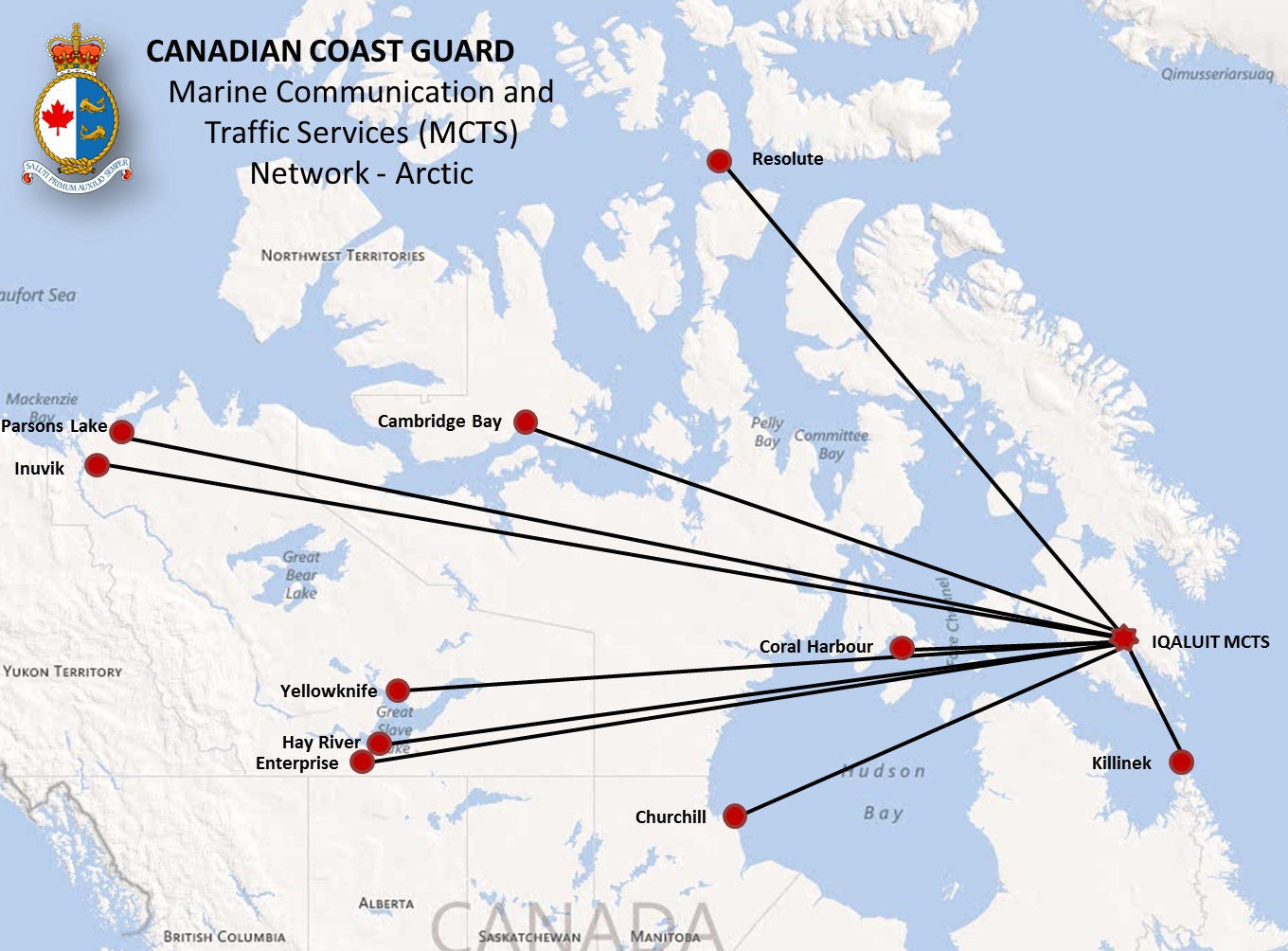
*615 CANADIAN COAST GUARD PUBLICATION - RADIO AIDS TO MARINE NAVIGATION (PACIFIC AND WESTERN ARCTIC) PUBLICATION - 2013 - FACILITY INFORMATION AMENDMENT.
Part 2 - Page 26 of 30
REPLACE the Diagram
CANADIAN COAST GUARD Marine Communications and Traffic Services (MCTS) Network - Arctic
WITH the Diagram at the following link
CANADIAN COAST GUARD Marine Communications and Traffic Services (MCTS) Network - Arctic
http://www.notmar.gc.ca/eng/services/notmar/sec5jun13eMCTSArcticE.jpg
SECTION 4
SAILING DIRECTIONS ANS SMALL CRAFT GUIDE CORRECTIONS
|
British Columbia, Volume1, Seventheenth Edition, 2004 - |
|
|
|
|
|
Chapter 10 - Delete paragraph 897, |
|
|
|
|
|
|
(P2013-04.1) |
|
PAC 201 |
Juan de Fuca Strait and Strait of Georgia, First Edition, 2012 |
|
|
|
|
Chapter 8 Paragraph 80 |
|
|
|
|
|
|
(P2013-03.1) |
SECTION 5
LIST OF LIGHTS, BUOYS AND FOG SIGNALS CORRECTIONS
|
No. |
Name |
Position |
Light |
Focal |
Noni- |
Description |
Remarks |
||||||||||||||||||
|
|
|||||||||||||||||||||||||
|
68.5 |
Bedwell Islands |
S. end of islet. |
Fl |
G |
4s |
8.9 |
5 |
White cylindrical tower, |
Radar reflector, |
|
|||||||||||||||
|
|
Chart:3679 |
||||||||||||||||||||||||
|
75 |
Rugged Islands |
N. point of N. island. |
Fl |
W |
4s |
10.0 |
5 |
White mast. |
Year round. |
|
|||||||||||||||
|
|
Chart:3680 |
||||||||||||||||||||||||
|
93 |
Ehatisaht |
On point, E. of |
Fl |
W |
4s |
6.8 |
5 |
Mast. |
|
Year round. |
|
||||||||||||||
|
|
Chart:3676 |
||||||||||||||||||||||||
|
312 |
Fraser River light |
SSW. of sand |
Q |
R |
1s |
----- |
----- |
Red, marked "SO". |
Year round. |
|
|||||||||||||||
|
|
Chart:3690 |
||||||||||||||||||||||||
|
428.1 |
Langdale Ferry |
|
|
Delete from List |
|||||||||||||||||||||
|
|
Chart:3526 |
||||||||||||||||||||||||
|
561 |
Jeannine Island |
On largest island. |
Fl |
W |
4s |
9.5 |
6 |
White cylindrical tower. |
Radar reflector, |
|
|||||||||||||||
|
|
Chart:3348 |
||||||||||||||||||||||||
|
624.8 |
Walsh Rock |
52 38 14 |
Q |
W |
1s |
7.0 |
5 |
White cylindrical tower. |
Year round. |
|
|||||||||||||||
|
|
Chart:3726 |
||||||||||||||||||||||||
|
640.5 |
Parry Patch Sector |
52 40 28.1 |
F |
W |
----- |
4.8 |
5 |
Mast. |
White 352° through N. and E. to |
||||||||||||||||
|
|
Chart:3911 |
||||||||||||||||||||||||
|
642 |
Tenas Island |
On NW. side of |
Fl |
R |
6s |
8.1 |
5 |
Square skeleton tower |
Flash 0.5s; eclipse 5.5 s. |
||||||||||||||||
|
|
Chart:3943 |
||||||||||||||||||||||||
|
652.5 |
Maintland Island |
53 42 08 |
Fl |
W |
4s |
8.2 |
5 |
White square skeleton |
Year round. |
|
|||||||||||||||
|
|
Chart:3743 |
||||||||||||||||||||||||
|
660 |
Staniforth Point |
On point. |
Fl(3) |
W |
12s |
6.9 |
5 |
Square skeleton tower |
Flash 0.5s; eclipse 2s; |
||||||||||||||||
|
|
Chart:3743 |
||||||||||||||||||||||||
|
661 |
Mary Point |
On point, Vemey |
Q |
W |
1s |
5.7 |
5 |
Square skeleton tower |
Year round. |
|
|||||||||||||||
|
|
Chart:3743 |
||||||||||||||||||||||||
CANADIAN COAST GUARD
MARINE INFORMATION REPORT AND SUGGESTION SHEET
Name of Ship or Sender:..................................................................... Date:...................................
Address of Sender:.........................................................................................................................
Street #
Street Name
Town / City:.............................. Prov / State:....................... Postal Code / Zip Code: ......................
Tel / Fax / E-mail address of sender (if appropriate):..........................................................................
Observation Date:............................................. Time (UTC): ..........................................................
Geographical Position:.....................................................................................................................
Coordinate Position: Lat: ................................................ Long:........................................................
Position Method: ○ DGPS ○ GPS with WAAS ○ GPS ○ Radar ○ Other
Horizontal Datum Used: ○ WGS 84 ○ NAD 27 ○ Other
Estimated Position Accuracy:...........................................................................................................
Chart #:............................................................ Datum: ○ NAD 27 ○ NAD 83
Chart Edition:.................................................... Last Correction applied:..........................................
Publications affected: (Quote Volume and page):...............................................................................
*Full details (Attach additional sheets as necessary)...........................................................................
Mariners are requested to notify the responsible authorities when new or suspected dangers to navigation are discovered, changes are observed in aids to navigation, or corrections to publications are seen to be necessary.
In the case of new or suspected dangers to navigation, it is important that all details be given in order to aid with future investigations. Items of interest include heights, depths, physical description, type of bottom and equipment method used to position the item. It is helpful to mark details on chart, which will be promptly replaced by the Canadian Hydrographic Service.
Reports should be made to the nearest Marine Communications and Traffic Services Centre (MCTS) and should be confirmed in writing to:
|
Director, Navigation Systems |
In the case of information concerning aids to navigation |
|
OR |
|
Dominion Hydrographer |
In the case of new or suspected dangers to navigation |
Or general questions on Coast Guard programs or services please send an e-mail message to:
info@dfo-mpo.gc.ca
(Please include your postal code and e-mail address)