
Archived information
The Standard on Web Usability replaces this content. This content is archived because Common Look and Feel 2.0 Standards have been rescinded.
Archived information is provided for reference, research or recordkeeping purposes. It is not subject to the Government of Canada Web Standards and has not been altered or updated since it was archived.
|
|
Fisheries and Oceans Canada |
Pêches et Ocèans Canada |
|
 |
|||
| MONTHLY EDITION No 04 April 25th, 2014 |
|||
|
CONTENTS |
|||
Page |
|||
| Section 1 |
Safety and General Information | 1 - 7 |
|
| Section 2 |
Chart Corrections | 8 - 20 |
|
| Section 3 |
Radio Aids to Marine Navigation Corrections | N/A |
|
| Section 4 |
Sailing Directions and Small Craft Guide Corrections | 21 |
|
| Section 5 |
List of Lights, Buoys and Fog signals Corrections | 22 |
|
Maritime Services Directorate Aids to Navigation |
|||
Fisheries and Oceans Canada - Official publication of the Canadian Coast Guard |
|||

Geographical positions refer directly to the graduations of the largest scale Canadian Hydrographic chart unless otherwise indicated.
Bearings refer to the true compass and are measured clockwise from 000° (North) clockwise to 359°; those relating to lights are from seaward.
Visibility of lights is that in clear weather.
Depths - The units used for soundings (metres, fathoms or feet) are stated in the title of each chart.
Elevations are normally given above Higher High Water, Large Tides unless otherwise indicated.
Distances may be calculated as follows:
1 nautical mile = 1 852 metres (6,076.1 feet)
1 statute mile = 1 609.3 metres (5,280 feet)
1 metre = 3.28 feet
Temporary & Preliminary Notices are indicated by a (T) or a (P) before the chart action and in the section 1. Please note that Nautical charts are not amended by the Canadian Hydrographic Service for Temporary (T) and Preliminary (P) Notices. It is recommended that mariners chart these corrections in pencil. Listing of charts affected by Temporary and Preliminary Notices are revised and promulgated quarterly in Section 1 of the Monthly Edition.
Please note that, in addition to the temporary and preliminary changes normally advertised as (T) and (P) Notices, there are a few permanent changes to navigational aids that have been advertised as Preliminary Notices to Mariners while charts are being updated for new editions.
Marine Information Report & Suggestion Sheet - Mariners are requested to notify the responsible authorities when new or suspected dangers to navigation are discovered, changes observed in aids to navigation or corrections to publications are seen to be necessary. Such communications can be made using the Marine Information Report & Suggestion Sheet inserted on the last page of each monthly edition of Notices to Mariners.
Canadian Hydrographic Service - Information Published in Section 2 Notices to Mariners - Mariners are advised that only the most critical changes that directly affect safety to navigation are issued in Chart Corrections - Section 2. This limitation is required to ensure that charts remain as clear and easy to read as possible. As a result, mariners may see minor discrepancies of a non-critical nature between information in official publications. For example, a small change in the nominal range or height of a light may not result in the production of a chart correction, in Notices to Mariners, but may result in a List of Light, Buoys and Fog Signals correction.
In case of discrepancy between information provided on CHS charts related to aids to navigation, and the List of Light publication, the latter shall be deemed as containing the most up to date information
Canadian Nautical Charts & Publications - A source list of Canadian Nautical Charts & Publications is
published in Notice No. 14 of the Notices to Mariners Annual Edition April 2011. The source supply and the prices
effective at the time of printing are listed. For current chart edition dates refer to the following web site:
http://www.chs-shc.gc.ca/charts-cartes/paper-papier/index-eng.asp
NOTE: Cette publication est aussi disponible en français.
Corrections to nautical charts will be listed in numeric order by chart number. Each chart correction listed applies only to that particular chart. Related charts, if any, will have their own specific correction listed separately.
Users should also refer to CHS Chart 1 Symbols, Abbreviations Terms for additional information pertaining to the correction of charts.
The illustration below describes the elements that will comprise a typical Section 2 chart correction.

MONTHLY EDITION OF NOTICES TO MARINERS
WEB ACCESS
We are offering a feature where subscribers to our on-line service are able to receive the complete electronic monthly edition of
our Notices to Mariners. We are encouraging our clients to visit the web site to subscribe for this service:
http://www.notmar.gc.ca/subscribe/
Users wishing to receive information updates for their charts can do so by setting up a ’User Profile’ on the following web page http://www.notmar.gc.ca/search/mycharts-eng.php?czoxOToibnRtPXN0ZXBfb25lJmxhbmc9ZSI7
This feature permits users to register the nautical charts they currently have in their possession. Registrants are then automatically notified by e-mail when a Notice to Mariners is published concerning these charts.
ADVISORY
NOTICES TO SHIPPING (WRITTEN AND BROADCAST)
The Canadian Coast Guard is implementing a number of changes to the aids to navigation system in Canada.
These changes are advertised as Notices to Shipping (Broadcast and Written) by the Canadian Coast Guard and are followed up with Notices to Mariners, then charts are updated by hand correction, reprints or new editions.
Mariners are advised that all relevant Written Notices to Shipping should be kept until superseded by Notices to Mariners or through revised charts issued by the Canadian Hydrographic Service.
Written Notices to Shipping are available on the Canadian Coast Guard Website at: www.ccg-gcc.gc.ca/eng/CCG/NOTSHIP.
The Canadian Hydrographic Service is reviewing the impact of these changes with the Canadian Coast Guard and together we are preparing an action plan on the issuing of chart revisions.
For further information contact your local Regional Notices to Shipping (NOTSHIP) issuing authorities.
Pacific Telephone: (604) 666-6011 RMIC Email: rmic-pacific@pac.dfo-mpo.gc.ca |
* Fisheries and Oceans Canada Telephone: (867) 979-5269 Email: IQANORDREG@INNAV.GC.CA |
* Services provided in English and French
INDEX
CANADIAN HYDROGRAPHIC SERVICE - ANNOUNCEMENT REGARDING CANADIAN HYDROGRAPHIC SERVICE CHART PATCHES. |
1 |
CANADIAN HYDROGRAPHIC SERVICE - CUMULATIVE CHART CORRECTIONS. |
1 |
CANADIAN HYDROGRAPHIC SERVICE - CURRENT CHART EDITION DATES. |
1 |
CANADIAN HYDROGRAPHIC SERVICE - PRINT ON DEMAND CHARTS - CARE AND USE. |
1 |
CANADIAN HYDROGRAPHIC SERVICE - TRANSPORT CANADA NAVIGATION SAFETY - ECDIS. |
2 |
CONSOLIDATION OF MARINE COMMUNICATIONS AND TRAFFIC SERVICES (MCTS) CENTRES. |
2 |
*401 SAGUENAY-ST. LAWRENCE MARINE PARK AND SURROUNDING WATERS - WHALE PROTECTION |
2 |
*402 CANADIAN HYDROGRAPHIC SERVICE - NAUTICAL CHARTS. |
4 |
*403 CANADIAN HYDROGRAPHIC SERVICE - ELECTRONIC NAVIGATIONAL CHARTS. |
4 |
*404 CANADIAN HYDROGRAPHIC SERVICE - RASTER DIGITAL CHARTS (BSB V4). |
5 |
*405 TRANSPORT CANADA - ACCEPTANCE OF NAUTICAL PUBLICATIONS IN ELECTRONIC FORM IN CANADA. |
5 |
*406 TRANSPORT CANADA – SHIP SAFETY BULLETIN. |
6 |
*407 CANADIAN COAST GUARD PUBLICATION - NEW EDITION OF THE ANNUAL EDITION OF NOTICES TO MARINERS – 2014. |
6 |
*408 CANADIAN COAST GUARD - LIST OF CHARTS AND REFERENCE CHARTS (SECTION I) AFFECTED BY TEMPORARY AND PRELIMINARY NOTICES. |
6 |
*409 CANADIAN HYDROGRAPHIC SERVICE – SAILING DIRECTIONS – ARC 402 — EASTERN ARCTIC, FIRST EDITION, 2014 IS NOW AVAILABLE AS A PRINT-ON-DEMAND (POD) PRODUCT. |
7 |
*424 STRAIT OF GEORGIA, SOUTHERN PORTION/PARTIE SUD – DAYBEACON PERMANENTLY REPLACED. |
7 |
NUMERICAL INDEX OF CANADIAN CHARTS AFFECTED
| Chart No. | Page | Chart No. | Page | Chart No. | Page |
| 1201 | 4 | 3825 | 15, 16 | 4449 | 6 |
| 1209 | 4 | 3853 | 16 | 4450 | 6 |
| 2305 | 6 | 3854 | 17 | 4466 | 6 |
| 3002 | 8 | 3859 | 17 | 4509 | 6 |
| 3311 | 8 | 3864 | 17 | 4512 | 6 |
| 3313 | 9 | 3902 | 18 | 4522 | 6 |
| 3443 | 10 | 3936 | 4 | 4596 | 6 |
| 3419 | 4 | 3945 | 18 | 4639 | 6 |
| 3442 | 9 | 3955 | 19 | 4642 | 6 |
| 3458 | 10 | 3956 | 19 | 4644 | 7 |
| 3461 | 10 | 3957 | 19 | 4669 | 7 |
| 3462 | 10, 11 | 3958 | 19 | 4670 | 7 |
| 3463 | 7 | 3977 | 4 | 4830 | 7 |
| 3475 | 11 | 4124 | 6 | 4844 | 7 |
| 3478 | 11 | 4201 | 6 | 4905 | 7 |
| 3481 | 12 | 4233 | 6 | 4909 | 7 |
| 3493 | 12 | 4243 | 6 | 4911 | 7 |
| 3544 | 12 | 4266 | 4, 6 | 4921 | 7 |
| 3668 | 12 | 4279 | 6 | 5051 | 7 |
| 3675 | 13 | 4281 | 6 | 6218 | 20 |
| 3743 | 4 | 4340 | 6 | 6267 | 7 |
| 3744 | 13 | 4377 | 6 | 6287 | 20 |
| 3808 | 14 | 4386 | 6 | 7950 | 4 |
| 3809 | 15 | 4396 | 6 | US 14884 | 7 |
CANADIAN HYDROGRAPHIC SERVICE - ANNOUNCEMENT REGARDING CANADIAN HYDROGRAPHIC SERVICE CHART PATCHES.
Colour Web Patches are free to the mariner, and given the quality of many printers, should reproduce well. They will be available in real time all around the world.
CHS welcomes your feedback on this service at chsinfo@dfo-mpo.gc.ca
CANADIAN HYDROGRAPHIC SERVICE - CUMULATIVE CHART CORRECTIONS.
The cumulative Notices to Mariners corrections for charts can now be accessed at
www.notmar.gc.ca/search/notmar-eng.php
CANADIAN HYDROGRAPHIC SERVICE - CURRENT CHART EDITION DATES.
CHART EDITIONS
The three terms described below are used to indicate the publication status of Canadian charts.
NEW CHART - "NEWCHT"
The first publication of a Canadian chart embracing an area not previously charted to the scale shown, or embracing an area different from any existing Canadian chart.
NEW EDITION - "NEWEDT"
A new issue of an existing chart containing amendments essential to navigation in addition to those issued in Notices to Mariners and making existing editions obsolete.
REPRINTS
A new issue of the current edition of a chart incorporating no amendments of navigational significance other than those previously promulgated in Notices to Mariners. It may also contain amendments from other sources provided they are not essential to navigation. Previous printings of the current edition remain in force
The current chart edition dates can be accessed at www.chs-shc.gc.ca/charts-cartes/paper-papier/index-eng.asp
CANADIAN HYDROGRAPHIC SERVICE - PRINT ON DEMAND CHARTS - CARE AND USE.
Background
By providing nautical charts to the public, the goal of the Canadian Hydrographic Service (CHS) is to provide services for safe navigation in a fiscally responsible manner. As a result, CHS continues to expand its portfolio of nautical paper charts that are printed using Print On Demand (POD) technology. These charts are easily recognized by their whiter paper and the coloured logo of the Canadian Hydrographic Service. This new technology enables CHS to print charts in a more efficient manner while enhancing chart content through being able to quickly add new and important information. POD technology provides customers with up-to-date charts without the historical hand-drawn corrections or glued-on patches. Additionally, this technology eliminates out-of-stock situations which arise with the traditional printing and warehousing methods. In the event of a national emergency, CHS can respond to the appropriate authorities with best available information very quickly.
Care of Your POD Chart
CHS encourages its customers to handle the POD charts more carefully than the traditional lithographic charts. When plotting information on POD charts, use HB pencils and apply limited pressure. Testing has suggested that an Indian gum eraser is more effective than alternatives when used on the product. This eraser is also suitable for charts printed using lithographic processes.
CANADIAN HYDROGRAPHIC SERVICE - TRANSPORT CANADA NAVIGATION SAFETY - ECDIS.
Mariners are advised that ECDIS may not display some isolated shoal depths when operating in "base or standard display" mode. Route planning and monitoring alarms for these shoal depths may not always be activated. To ensure safe navigation and to confirm that a planned route is clear of such dangers, mariners should visually inspect the planned route and any deviations from it using ECDIS configured to display "all data". The automated voyage planning check function should not be solely relied upon.
CONSOLIDATION OF MARINE COMMUNICATIONS AND TRAFFIC SERVICES (MCTS) CENTRES
The Canadian Coast Guard is consolidating and modernizing its Marine Communications and Traffic Services. These changes will result in a configuration of 12 MCTS Centres strategically located across the country by spring 2015. Information pertaining to consolidation will be advertised to clients by all available means.
Phase I (completed Spring 2014)
Western Region
Tofino MCTS will close; services will be provided remotely by Prince Rupert MCTS
Phase II (completed Spring 2015)
Western Region
Comox MCTS and Vancouver MCTS will close; services will be provided remotely by Victoria MCTS
There will be no reduction in the MCTS level of service provided to clients. Mariners should be aware that, as a result of consolidation, contact information, weather and other pertinent marine broadcast schedules may change.
These changes will be advertised in RAMN, as they become available.
Mariners should check NOTMAR PART 3 on a monthly basis for updates.
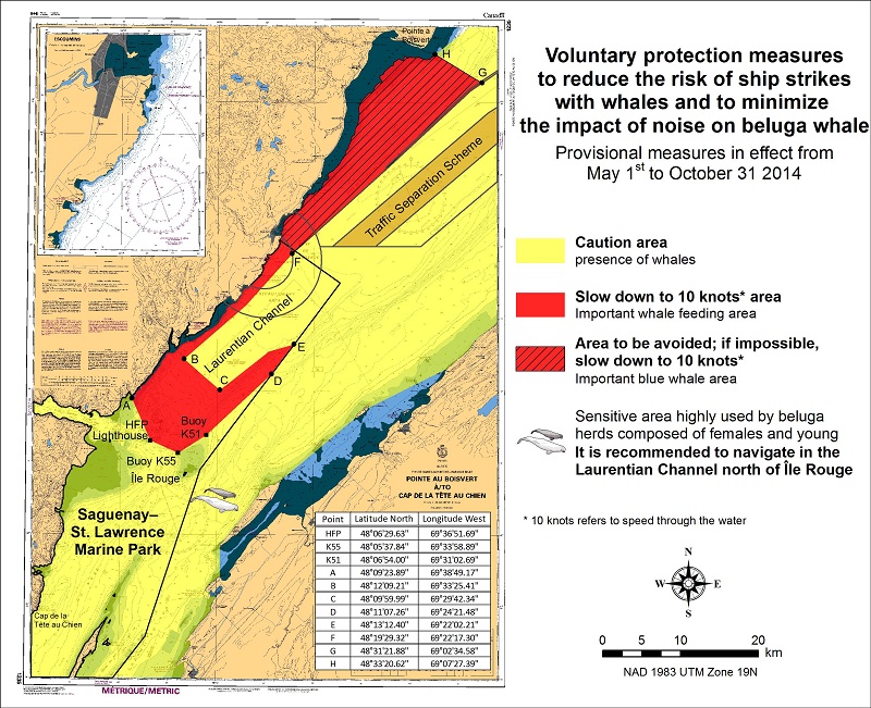
*401 SAGUENAY-ST. LAWRENCE MARINE PARK AND SURROUNDING WATERS - WHALE PROTECTION
The waters in and around the Saguenay-St. Lawrence Marine Park are well known for their resident threatened beluga
population and the wide diversity of whales that migrate there to feed, particularly between April and November.
REGULATORY PROTECTION MEASURES
All whale species that are found in the St. Lawrence are protected under the Marine Mammal Regulations, pursuant to the
Fisheries Act. Within the boundaries of the Marine Park, specific measures are set out in the Marine Activities in the
Saguenay–St. Lawrence Marine Park Regulations, pursuant to the Act Establishing the Saguenay-St. Lawrence Marine Park.
Any collision with a marine mammal within the Marine Park must immediately be reported to a park warden at 1-866-508-9888.
For collisions that occur outside the Marine Park or for any situation involving a marine mammal that is dead or in trouble,
contact the emergency network at 1-877-722-5346 or on channel 16. (see section 5C of the Annual Edition of the Notices to Mariners – April 2014 to March 2015).
VOLUNTARY PROTECTION MEASURES
Provisional measures in effect from May 1 to October 31, 2014
These measures apply to merchant vessels and cruise ships between Pointe à Boisvert and Cap de la Tête au Chien to
prevent collisions with whales (see link below to view map). These measures should only be taken when they will not jeopardize navigational safety.
Caution area (yellow area): To reduce the risk of collisions with whales that can be present anywhere in this area,
heightened vigilance is critical for navigators. Posting a lookout is recommended in order to increase the chances of
seeing the whales and thus taking necessary measures to avoid them. If bypassing the whales is not possible, slow down
and wait for the animals to move away to a distance greater than 400 meters (0.215 nautical miles) before resuming original speed.
It is more difficult to see the animals at night therefore increased caution is recommended.
Slow down to 10 knots area (red area): To reduce the risk of collisions with whales in this feeding area, it is recommended
that vessels slow down to a maximum speed through the water of 10 knots and post a lookout. It is further recommended to remain
in the Laurentian Channel to the north of île Rouge to minimize the impact of noise in a sensitive area south of this island,
which is highly frequented by herds of beluga whales composed of females and young.
Area to be avoided (hatched red area): To reduce noise and the risk of collisions with whales, vessels should avoid
transiting through this area which is highly frequented by blue whales, an endangered species. If the area cannot be
avoided, slow down to a maximum speed through the water of 10 knots.
See attached map:
*402 CANADIAN HYDROGRAPHIC SERVICE - NAUTICAL CHARTS.
| CHARTS | MAIN TITLE | SCALE | PUBLISHED | CAT# | PRICE |
| New Charts | |||||
| 1201 | Saint-Fulgence à/to Saguenay | 1:15000 | 07-FEB-2014 | 1 | |
| 3977 | Douglas Channel | 1:80000 | 27-DEC-2013 | 20.00 | |
| New Editions | |||||
| 3419 | Esquimalt Harbour | 1:5000 | 13-DEC-2013 | 2 | 20.00 |
| 3936 | Fitz Hugh Sound to/à Lama Passage | 1:40000 | 21-MAR-2014 | 2 | |
| 4266 | Sydney Harbour | 1:20000 | 28-FEB-2014 | 1 | 20.00 |
| 7950 | Jones Sound,Norwegian Bay and Queens Channel | 1:500000 | 21-JUN-2013 | 4 | 20.00 |
| Charts Permanently Withdrawn | |||||
| 1209 | Saint-Fulgence à/to Rivière Shipshaw | ||||
| 3743 | Douglas Channel | ||||
*403 CANADIAN HYDROGRAPHIC SERVICE - ELECTRONIC NAVIGATIONAL CHARTS.
| NEW PRODUCTS | |
| S-57 ENC NUMBER | CHART TITLE |
| CA370603 | Douglas Channel |
| CA370720 | Nootka Sound to/à Quatsino Sound (part 2 of 2) |
| CA370721 | Douglas Channel |
| CA376363 | Cut Throat Island to/à Quaker Hat |
| CA470604 | Douglas Channel - Central Portion/Partie Centrale |
| CA473456 | Approaches to/à Koojesse Inlet |
| CA476323 | Great Bay de l'Eau and Approaches/et les approches |
| CA476365 | Holton Harbour |
| CA476366 | Ice Tickle and/et Indian Harbour |
| CA570715 | Prince Rupert Harbour (part 2 of 2) |
| CA570716 | Trail Bay |
| CA570717 | Tsowwin Narrows |
| CA570718 | Welcome Bay |
| CA570719 | Port Mellon |
| CA576324 | Harbour Breton |
| CA576364 | Cut Throat Harbour and/et East Harbour |
| CA579237 | Saint-Fulgence à/to Saguenay |
| WITHDRAWN PRODUCTS | |
| CA470349 | Burke Channel |
| CA570066 | Venn Passage |
| CA570067 | Porpoise Harbour, Ridley Island and Approaches/et les approches |
| CA570068 | Morse Basin and/et Denise Inlet |
| CA570126 | Butze Rapids |
| CA579077 | Saint-Fulgence à/to Rivière Shipshaw |
| CA579095 | Chicoutimi à Rivière Shipshaw - Continuation A |
*404 CANADIAN HYDROGRAPHIC SERVICE - RASTER DIGITAL CHARTS (BSB V4).
| CHARTS | MAIN TITLE | SCALE | PUBLISHED |
| New Charts | |||
| R/M7184 | Broughton Island and Approaches/et les Approches | 1:50000 | 31-AUG-2012 |
| New Editions | |||
| R/M1310 | Port de Montréal | 1:15000 | 10-JAN-2014 |
| R/M3412 | Victoria Harbour | 1:12000 | 22-NOV-2013 |
| R/M4440 | Îles Sainte-Marie à/to Île à la Brume | 1:75000 | 19-JUL-2013 |
| R/M4722 | Terrington Basin | 1:6000 | 25-OCT-2013 |
*405 TRANSPORT CANADA - ACCEPTANCE OF NAUTICAL PUBLICATIONS IN ELECTRONIC FORM IN CANADA.
- The Charts and Nautical Publication Regulations, 1995 (CNPR) require the carriage and use of several nautical publications. Many nautical publications in Canada are now available in electronic form and can be downloaded from the internet in PDF (chart catalogue, Monthly Notices to Mariners (NOTMARS), List of Lights, Buoys and Fog Signal, Annual Edition of Notices to Mariners, Radio aids to Marine Navigation, CCG Ice Navigation in Canadian Waters). Some vessels may carry publications in electronic form issued by another Administration (i.e., Admiralty Digital Publications) as per CNPR subsection 6(3).
- IMO circular entitled IMO requirements on carriage of publications on board ships (MSC-MEPC.2/Circ.2) allows electronic publications provided they have been issued by the IMO, an Administration or an organization authorized by an Administration. The electronic document should also “be treated in accordance with the document control procedures in the ship’s SMS including procedures for timely update.” However, as an exception, IMO does require the International Code of Signals and the IAMSAR - Volume III must be always available in hard copy to ensure accessibility and portability for emergency use.
- Under SOLAS, charts and nautical publications in electronic form can be used to meet SOLAS V carriage requirements provided suitable back-up arrangements are in place.
- The CNPR provide detailed requirements for nautical publications. Electronic nautical publications
must meet the same requirements as the hard copies.
For example:- The publication must be published, or issued, by the appropriate authority,
- The publication must be complete for the area to be navigated and up to date.
There should be an appropriate back-up onboard. The primary system should have an emergency source of power.
Updates should be applied to both the primary and back-up system as soon as practical. When in port, they should be applied prior to passage planning and commencement of the voyage.
As the publications required by the CNPR must be on board, simply being able to access the publications through the internet would not be considered on board and therefore not acceptable. However, publications downloaded and saved on board or hard copies printed from official internet sources would be acceptable.
*406 TRANSPORT CANADA – SHIP SAFETY BULLETIN.
This is to notify you that a new Ship Safety Bulletin has recently been posted to the Transport Canada website
at: http://www.tc.gc.ca/eng/marinesafety/bulletins-menu.htm
To go online to view or download this bulletin, please click on the link below:
Subject: Proper Technical Maintenance of Freight Containers and Safe Stuffing Practices
Issue: Bulletin No.: 01/2014
Date: 2014-03-11
Link: http://www.tc.gc.ca/eng/marinesafety/bulletins-2014-01-eng.htm
Sign yourself up for e-Bulletin to receive an e-mail notice each time a new Ship Safety Bulletin is published on our
Web site.
Contact us at: marinesafety-securitemaritime@tc.gc.ca or 1-855-859-3123 (Toll Free).
*407 CANADIAN COAST GUARD PUBLICATION - NEW EDITION OF THE ANNUAL EDITION OF NOTICES TO MARINERS – 2014.
The 2014 edition of the Annual Edition of Notices to Mariners publication is now available for download, free of charge,
on the NOTMAR web site at http://www.notmar.gc.ca/go.php?doc=eng/services/annual/default-eng.
Paper copies of the publication will no longer be sold.
Amendments to this publication are advertised in the Section 1 of the monthly edition of Notices to Mariners http://www.notmar.gc.ca.
The 2014 edition has been revised up to Edition 12, 2013 and supersedes the 2013 edition.
*408 CANADIAN COAST GUARD - LIST OF CHARTS AND REFERENCE CHARTS (SECTION I) AFFECTED BY TEMPORARY AND PRELIMINARY NOTICES.
IN EFFECT MARCH 28, 2014
(REVISED AND PROMULGATED QUARTERLY)
| 2305 | 1204(P)/08 |
| 4124 | 307(P)/14 |
| 4201 | 509(P) /13 |
| 4233 | 210(P)/12 |
| 4243 | 711(P)/13; 308(P)/14 |
| 4266 | 608(P)/12, 609(P)/12 |
| 4279 | 1210(P)/13 |
| 4281 | 1111(P)/11 |
| 4340 | 305(P) /14; 306(P) /14 |
| 4377 | 405(P)/13 |
| 4386 | 1107(P)/13; 1108(P)/13 |
| 4396 | 510(P)/13 |
| 4449 | 1211(P)/13; 106(P)/14 |
| 4450 | 1005(P)/13; 1006(P)/13 |
| 4466 | 109(P)/14 |
| 4509 | 114(P)/14 |
| 4512 | 1205(P) /13;115(P)/14 |
| 4522 | 1103(T) /13; 1207(T) /13; |
| 4596 | 1209(T) /13; |
| 4639 | 113(P)/14 |
| 4642 | 111(P)/14 |
| 4644 | 112(P)/14 |
| 4669 | 116(P)/14 |
| 4670 | 1206(T) /13; |
| 4830 | 1104(T) /13; |
| 4844 | 110(P)/14 |
| 4905 | 204(P) /14 |
| 4909 | 613(P)/12, 810(P)/12; 205(P) /14; 206 (P) /14; 207(P) /14; 304(P) /14 |
| 4911 | 811(P)/12, 612(P)/13 |
| 4921 | 713(P)/13 |
| 5051 | 1208(T) /13; |
| 6267 | 112(P)/06 |
| US 14884 | 715(T)/13 |
*409 CANADIAN HYDROGRAPHIC SERVICE – SAILING DIRECTIONS – ARC 402 — EASTERN ARCTIC, FIRST EDITION, 2014 IS NOW AVAILABLE AS A PRINT-ON-DEMAND (POD) PRODUCT.
Sailing Directions booklet ARC 402 — Eastern Arctic, First Edition, 2014 is now available as a Print-on-Demand (POD) product. This new booklet cancels and replaces Sailing Directions, Arctic Canada, Volume II, Fourth Edition, 1985 and the remainder of Sailing Directions, Arctic Canada, Volume 3, Fifth Edition, 1994. POD booklets are corrected through Section 4 of Notices to Mariners up to the date of printing. The price of ARC 402 — Eastern Arctic, First Edition, 2014, is $26.95. Advance orders may be made through any Chart Dealer.
*424 STRAIT OF GEORGIA, SOUTHERN PORTION/PARTIE SUD – DAYBEACON PERMANENTLY REPLACED.
Reference Chart: 3463
Nicomekl River Daybeacon #17 has been permanently replaced with a green buoy marked R17 (49° 03' 32.6"N 122° 52' 22.5"W).
| 3002 - Queen Charlotte Sound to/à Dixon Entrance - New Edition - 16-DEC-1994 - NAD 1927 | |||
| 25-APR-2014 | LNM/D. 26-OCT-2012 | ||
| Add | marine park (See Chart No. 1, Nf) This notice affects Electronic Navigational Chart: CA270390 |
joining 52°48′42.0″N 131°39′22.0″W 52°50′05.0″N 131°20′10.0″W 52°26′49.0″N 131°05′19.0″W 52°12′29.0″N 130°49′00.0″W 51°47′58.0″N 130°53′31.0″W 52°00′00.0″N 131°18′00.0″W 52°40′36.0″N 132°13′16.0″W and 52°44′10.0″N 132°06′17.0″W |
|
| DFO(6202727-04) | |||
| Add | National park, marked NPR/RPN (See Chart No. 1 Ef) |
52°30′00.0″N 131°52′00.0″W | |
| DFO(6202727-05) | |||
| Add | GWAII HAANAS NATIONAL PARK RESERVE,
NATIONAL MARINE CONSERVATION AREA
RESERVE AND HAIDA HERITAGE SITE
NPR
RÉSERVE DE PARC NATIONAL GWAII HAANAS,
RÉSERVE D′AIRE MARINE NATIONALE DE
CONSERVATION ET SITE DU PATRIMOINE HAÏDA
RPN This notice affects Electronic Navigational Chart: CA270390 |
||
| DFO(6202727-06) | |||
| 3311 - Port Moody to/à Howe Sound - Sheet/Feuille 1 - New Edition - 31-DEC-1993 - NAD 1983 | |||
| 25-APR-2014 | LNM/D. 20-DEC-2013 | ||
| Delete | light Fl R (See Chart No. 1, P1) This notice affects Electronic Navigational Chart: CA470072, CA570073 |
49°16′45.0″N 123°08′51.0″W | |
| DFO(6202831-01) | |||
| 3313 - Swanson Channel - Sheet/Feuille 8 - New Edition - 02-JAN-2009 - NAD 1983 | |||
| 04-APR-2014 | LNM/D. 21-FEB-2014 | ||
| Add | seaplane landing area (See Chart No. 1, N13) This notice affects Electronic Navigational Chart: CA470005, CA570239 |
joining 48°51′11.0″N 123°29′24.0″W 48°50′34.5″N 123°28′04.5″W 48°50′29.0″N 123°28′11.5″W 48°51′05.5″N 123°29′30.5″W and 48°51′11.0″N 123°29′24.0″W |
|
| DFO(6202823-01) | |||
| 3313 - Captain Passage - Sheet/Feuille 10 - New Edition - 02-JAN-2009 - NAD 1983 | |||
| 04-APR-2014 | LNM/D. 21-FEB-2014 | ||
| Add | seaplane landing area (See Chart No. 1, N13) This notice affects Electronic Navigational Chart: CA470005, CA570239 |
joining 48°51′11.0″N 123°29′24.0″W 48°50′34.5″N 123°28′04.5″W 48°50′29.0″N 123°28′11.5″W 48°51′05.5″N 123°29′30.5″W and 48°51′11.0″N 123°29′24.0″W |
|
| DFO(6202823-01) | |||
| 3442 - North Pender Island to/à Thetis Island - New Edition - 01-JUL-2005 - NAD 1983 | |||
| 04-APR-2014 | LNM/D. 27-MAY-2011 | ||
| Add | seaplane landing area (See Chart No. 1, N13) This notice affects Electronic Navigational Chart: CA470005, CA570239 |
joining 48°51′11.0″N 123°29′24.0″W 48°50′34.5″N 123°28′04.5″W 48°50′29.0″N 123°28′11.5″W 48°51′05.5″N 123°29′30.5″W and 48°51′11.0″N 123°29′24.0″W |
|
| DFO(6202823-01) | |||
| 3443 - Thetis Island to/à Nanaimo - New Edition - 20-DEC-2002 - NAD 1983 | |||
| 11-APR-2014 | LNM/D. 22-NOV-2013 | ||
| Reposition | Anchor Berth marked 1 | from 49°08′39.0″N 123°50′22.2″W to 49°08′45.6″N 123°50′52.8″W |
|
| DFO(6202825-01) | |||
| 3458 - Approaches to/Approches à Nanaimo Harbour - New Edition - 10-MAR-1995 - NAD 1983 | |||
| 11-APR-2014 | LNM/D. 28-JUN-2013 | ||
| Reposition | Anchor Berth marked 1 | from 49°08′39.0″N 123°50′22.2″W to 49°08′45.6″N 123°50′52.8″W |
|
| DFO(6202825-01) | |||
| 3461 - Juan de Fuca Strait, Eastern Portion/Partie Est - New Edition - 01-JUL-2005 - NAD 1983 | |||
| 25-APR-2014 | LNM/D. 30-AUG-2013 | ||
| Amend | Fl 7m6M to read Fl 8m5M against light (See Chart No. 1, P10.4) |
48°19′27.0″N 122°49′09.5″W | |
| DFO(6202829-01) | |||
| 3462 - Juan de Fuca Strait to/à Strait of Georgia - New Edition - 01-JUL-2005 - NAD 1983 | |||
| 25-APR-2014 | LNM/D. 04-APR-2014 | ||
| Amend | FR marked Priv to read FY marked Priv against light (See Chart No. 1, P10.1) This notice affects Electronic Navigational Chart: CA370368 |
48°51′36.0″N 122°45′21.0″W | |
| DFO(6202828-01) | |||
| Amend | FR marked Priv to read FY marked Priv against light (See Chart No. 1, P10.1) This notice affects Electronic Navigational Chart: CA370368 |
48°51′43.5″N 122°45′32.5″W | |
| DFO(6202828-02) | |||
| Add | light F Y marked Priv (See Chart No. 1, P1) This notice affects Electronic Navigational Chart: CA370368 |
48°51′46.0″N 122°45′40.0″W | |
| DFO(6202828-03) | |||
| Add | light F Y marked Priv (See Chart No. 1, P1) This notice affects Electronic Navigational Chart: CA370368 |
48°51′51.5″N 122°45′51.5″W | |
| DFO(6202828-04) | |||
| 04-APR-2014 | LNM/D. 21-FEB-2014 | ||
| Amend | FR marked Priv to read FY marked Priv against light (See Chart No. 1, P1) This notice affects Electronic Navigational Chart: CA370368 |
48°49′39.5″N 122°43′09.5″W | |
| DFO(6202824-01) | |||
| Amend | FR marked Priv to read FY marked Priv against light (See Chart No. 1, P1) This notice affects Electronic Navigational Chart: CA370368 |
48°49′30.0″N 122°43′13.5″W | |
| DFO(6202824-02) | |||
| 3475 - Dodd Narrows to/à Flat Top Islands - New Edition - 30-DEC-2005 - NAD 1983 | |||
| 11-APR-2014 | LNM/D. 22-NOV-2013 | ||
| Reposition | Anchor Berth marked 1 | from 49°08′39.0″N 123°50′22.2″W to 49°08′45.6″N 123°50′52.8″W |
|
| DFO(6202825-01) | |||
| 3478 - Ganges Harbour and/et Long Harbour - New Edition - 12-JUL-2013 - NAD 1983 | |||
| 04-APR-2014 | |||
| Add | seaplane landing area (See Chart No. 1, N13) This notice affects Electronic Navigational Chart: CA470005, CA570239 |
joining 48°51′11.0″N 123°29′24.0″W 48°50′34.5″N 123°28′04.5″W 48°50′29.0″N 123°28′11.5″W 48°51′05.5″N 123°29′30.5″W and 48°51′11.0″N 123°29′24.0″W |
|
| DFO(6202823-01) | |||
| 3481 - Approaches to/Approches à Vancouver Harbour - New Edition - 06-APR-2012 - NAD 1983 | |||
| 25-APR-2014 | LNM/D. 01-NOV-2013 | ||
| Delete | light Fl R, marked Priv (See Chart No. 1, P1) This notice affects Electronic Navigational Chart: CA470072, CA570073 |
49°16′45.0″N 123°08′51.0″W | |
| DFO(6202831-01) | |||
| 3493 - Vancouver Harbour Western Portion/Partie Ouest - New Edition - 11-JUN-2010 - NAD 1983 | |||
| 25-APR-2014 | LNM/D. 01-NOV-2013 | ||
| Delete | light Fl R, marked Priv (See Chart No. 1, P1) This notice affects Electronic Navigational Chart: CA470072, CA570073 |
49°16′45.0″N 123°08′51.0″W | |
| DFO(6202831-01) | |||
| 3544 - Johnstone Strait, Race Passage and/et Current Passage - New Edition - 25-SEP-1987 - NAD 1983 | |||
| 04-APR-2014 | LNM/D. 16-JUN-2006 | ||
| Amend | FlR to read FlY against light (See Chart No. 1, P10.4) This notice affects Electronic Navigational Chart: CA470022 |
50°23′46.4″N 125°57′31.3″W | |
| (P2014011) LL(534.5) DFO(6202814-01) | |||
| 3668 - Port Alberni - New Edition - 07-APR-2000 - NAD 1983 | |||
| 18-APR-2014 | LNM/D. 07-MAR-2014 | ||
| Delete | radar reflector (See Chart No. 1, S4) This notice affects Electronic Navigational Chart: CA570168 |
49°14′37.0″N 124°49′21.0″W | |
| (P2014009) DFO(6202812-01) | |||
| Delete | radar reflector (See Chart No. 1, S4) This notice affects Electronic Navigational Chart: CA570168 |
49°14′29.8″N 124°49′20.3″W | |
| (P2014008) DFO(6202812-02) | |||
| 3675 - Gold River - New Chart - 20-NOV-1998 - NAD 1983 | |||
| 11-APR-2014 | LNM/D. 30-OCT-2009 | ||
| Delete | depth of 22.1 metres (See Chart No. 1, I10) This notice affects Electronic Navigational Chart: CA570277 |
49°40′26.8″N 126°07′33.8″W | |
| DFO(6202827-01) | |||
| Add | depth of 11.5 metres (See Chart No. 1, I10) This notice affects Electronic Navigational Chart: CA570277 |
49°40′27.0″N 126°07′35.0″W | |
| DFO(6202827-02) | |||
| Add | depth of 3.1 metres (See Chart No. 1, I10) This notice affects Electronic Navigational Chart: CA570277 |
49°40′41.5″N 126°07′00.5″W | |
| DFO(6202827-03) | |||
| 3744 - Queen Charlotte Sound - New Edition - 20-MAY-1988 - NAD 1927 | |||
| 25-APR-2014 | LNM/D. 26-OCT-2012 | ||
| Add | marine park (See Chart No. 1, Nf) This notice affects Electronic Navigational Chart: CA270084 |
joining 51°56′37.0″N 131°10′54.0″W 51°47′59.0″N 130°53′25.0″W 52°12′30.0″N 130°48′54.0″W 52°26′50.0″N 131°05′13.0″W and 52°35′47.0″N 131°10′54.0″W |
|
| DFO(6202727-20) | |||
| Add | National park, marked NPR/RPN (See Chart No. 1 Ef) This notice affects Electronic Navigational Chart: CA270084 |
52°08′00.0″N 130°54′00.0″W | |
| DFO(6202727-21) | |||
| Add | GWAII HAANAS NATIONAL PARK RESERVE,
NATIONAL MARINE CONSERVATION AREA
RESERVE AND HAIDA HERITAGE SITE
NPR
RÉSERVE DE PARC NATIONAL GWAII HAANAS,
RÉSERVE D′AIRE MARINE NATIONALE DE
CONSERVATION ET SITE DU PATRIMOINE HAÏDA
RPN This notice affects Electronic Navigational Chart: CA270084 |
53°45′00.0″N 129°25′30.0″W | |
| DFO(6202727-22) | |||
| 3808 - Juan Perez Sound - New Edition - 30-DEC-2005 - NAD 1983 | |||
| 25-APR-2014 | LNM/D. 09-NOV-2012 | ||
| Add | marine park (See Chart No. 1, Nf) This notice affects Electronic Navigational Chart: CA470330 |
between 52°37′30.0″N 131°12′06.0″W and 52°40′16.2″N 131°13′52.0″W |
|
| DFO(6202727-12) | |||
| Add | GWAII HAANAS NATIONAL PARK RESERVE, NATIONAL MARINE CONSERVATION AREA RESERVE AND HAIDA HERITAGE SITE
RÉSERVE DE PARC NATIONAL GWAII HAANAS, RÉSERVE D′AIRE MARINE NATIONALE DE CONSERVATION ET SITE DU PATRIMOINE HAÏDA This notice affects Electronic Navigational Chart: CA470330 |
52°38′36.0″N 131°12′54.0″W | |
| DFO(6202727-13) | |||
| Amend | GWAII HAANAS NATIONAL PARK RESERVE AND HAIDA HERITAGE SITE
RESÉRVE DE PARC NATIONAL ET SITE DU PATRIMOINE HAÏDA GWAII HAANAS to read GWAII HAANAS NATIONAL PARK RESERVE, NATIONAL MARINE CONSERVATION AREA RESERVE AND HAIDA HERITAGE SITE RÉSERVE DE PARC NATIONAL GWAII HAANAS, RÉSERVE D′AIRE MARINE NATIONALE DE CONSERVATION ET SITE DU PATRIMOINE HAÏDA This notice affects Electronic Navigational Chart: CA470330 |
52°29′00.0″N 131°32′00.0″W | |
| DFO(6202727-27) | |||
| Amend | GWAII HAANAS NATIONAL PARK RESERVE AND HAIDA HERITAGE SITE
RESÉRVE DE PARC NATIONAL ET SITE DU PATRIMOINE HAÏDA GWAII HAANAS to read GWAII HAANAS NATIONAL PARK RESERVE, NATIONAL MARINE CONSERVATION AREA RESERVE AND HAIDA HERITAGE SITE RÉSERVE DE PARC NATIONAL GWAII HAANAS, RÉSERVE D′AIRE MARINE NATIONALE DE CONSERVATION ET SITE DU PATRIMOINE HAÏDA |
52°39′30.0″N 131°35′30.0″W | |
| DFO(6202727-28) | |||
| 3809 - Carpenter Bay to/à Burnaby Island - New Edition - 24-AUG-1979 - NAD 1927 | |||
| 25-APR-2014 | LNM/D. 12-OCT-2012 | ||
| Add | marine park (See Chart No. 1, Nf) This notice affects Electronic Navigational Chart: CA470380 |
joining 52°27′21.0″N 131°05′32.0″W 52°26′50.0″N 131°05′13.0″W and 52°16′31.0″N 130°53′33.0″W |
|
| DFO(6202727-09) | |||
| Add | GWAII HAANAS NATIONAL PARK RESERVE, NATIONAL MARINE CONSERVATION AREA RESERVE AND HAIDA HERITAGE SITE
RÉSERVE DE PARC NATIONAL GWAII HAANAS, RÉSERVE D′AIRE MARINE NATIONALE DE CONSERVATION ET SITE DU PATRIMOINE HAÏDA This notice affects Electronic Navigational Chart: CA470380 |
52°21′36.0″N 130°59′30.0″W | |
| DFO(6202727-11) | |||
| 3825 - Cape St. James to/à Houston Stewart Channel - New Edition - 22-SEP-2006 - NAD 1983 | |||
| 25-APR-2014 | LNM/D. 05-APR-2013 | ||
| Add | marine park (See Chart No. 1, Nf) |
between 51°59′04.0″N 131°16′06.0″W and 51°50′00.0″N 130°57′38.0″W |
|
| DFO(6202727-14) | |||
| Add | marine park (See Chart No. 1, Nf) |
between 51°50′00.0″N 130°53′08.0″W and 52°06′33.0″N 130°50′06.0″W |
|
| DFO(6202727-15) | |||
| Add | GWAII HAANAS NATIONAL PARK RESERVE, NATIONAL MARINE CONSERVATION AREA RESERVE AND HAIDA HERITAGE SITE RÉSERVE DE PARC NATIONAL GWAII HAANAS, RÉSERVE D′AIRE MARINE NATIONALE DE CONSERVATION ET SITE DU PATRIMOINE HAÏDA | 51°55′30.0″N 131°08′30.0″W | |
| DFO(6202727-16) | |||
| Add | GWAII HAANAS NATIONAL PARK RESERVE, NATIONAL MARINE CONSERVATION AREA RESERVE AND HAIDA HERITAGE SITE RÉSERVE DE PARC NATIONAL GWAII HAANAS, RÉSERVE D′AIRE MARINE NATIONALE DE CONSERVATION ET SITE DU PATRIMOINE HAÏDA | 52°03′06.0″N 130°51′00.0″W | |
| DFO(6202727-17) | |||
| Amend | GWAII HAANAS NATIONAL PARK RESERVE AND HAIDA HERITAGE SITE
RESÉRVE DE PARC NATIONAL ET SITE DU PATRIMOINE HAÏDA GWAII HAANAS to read GWAII HAANAS NATIONAL PARK RESERVE, NATIONAL MARINE CONSERVATION AREA RESERVE AND HAIDA HERITAGE SITE RÉSERVE DE PARC NATIONAL GWAII HAANAS, RÉSERVE D′AIRE MARINE NATIONALE DE CONSERVATION ET SITE DU PATRIMOINE HAÏDA |
51°59′12.0″N 131°03′00.0″W | |
| DFO(6202727-29) | |||
| Amend | GWAII HAANAS NATIONAL PARK RESERVE AND HAIDA HERITAGE SITE
RESÉRVE DE PARC NATIONAL ET SITE DU PATRIMOINE HAÏDA GWAII HAANAS to read GWAII HAANAS NATIONAL PARK RESERVE, NATIONAL MARINE CONSERVATION AREA RESERVE AND HAIDA HERITAGE SITE RÉSERVE DE PARC NATIONAL GWAII HAANAS, RÉSERVE D′AIRE MARINE NATIONALE DE CONSERVATION ET SITE DU PATRIMOINE HAÏDA |
52°09′30.0″N 131°10′30.0″W | |
| DFO(6202727-30) | |||
| 3853 - Cape St. James to/à Cumshewa Inlet and/et Tasu Sound - New Edition - 02-MAR-1990 - NAD 1927 | |||
| 25-APR-2014 | LNM/D. 30-NOV-2012 | ||
| Add | marine park (See Chart No. 1, Nf) |
joining 51°48′52.0″N 130°55′13.0″W 52°00′01.0″N 131°17′54.0″W 52°40′37.0″N 132°13′10.0″W and 52°44′06.0″N 132°06′24.0″W |
|
| DFO(6202727-01) | |||
| Add | GWAII HAANAS NATIONAL PARK RESERVE, NATIONAL MARINE CONSERVATION AREA RESERVE AND HAIDA HERITAGE SITE RÉSERVE DE PARC NATIONAL GWAII HAANAS, RÉSERVE D′AIRE MARINE NATIONALE DE CONSERVATION ET SITE DU PATRIMOINE HAÏDA | 52°23′36.0″N 131°47′48.0″W | |
| DFO(6202727-02) | |||
| Add | marine park (See Chart No. 1, Nf) |
joining 52°48′37.0″N 131°39′21.0″W 52°50′06.0″N 131°20′04.0″W 52°26′50.0″N 131°05′13.0″W 52°12′30.0″N 130°48′54.0″W and 51°48′52.0″N 130°53′15.0″W |
|
| DFO(6202727-03) | |||
| 3854 - Tasu Sound to/à Port Louis - New Edition - 23-OCT-1987 - NAD 1927 | |||
| 25-APR-2014 | LNM/D. 30-NOV-2012 | ||
| Add | marine park (See Chart No. 1, Nf) |
between 52°42′01.0″N 132°10′18.0″W and 52°44′07.0″N 132°06′24.0″W |
|
| DFO(6202727-23) | |||
| Add | National park, marked NPR/RPN (See Chart No. 1 Ef) |
52°42′30.0″N 132°05′00.0″W | |
| DFO(6202727-24) | |||
| Add | GWAII HAANAS NATIONAL PARK RESERVE, NATIONAL MARINE CONSERVATION AREA RESERVE AND HAIDA HERITAGE SITE NPR RÉSERVE DE PARC NATIONAL GWAII HAANAS, RÉSERVE D′AIRE MARINE NATIONALE DE CONSERVATION ET SITE DU PATRIMOINE HAÏDA RPN | 52°53′30.0″N 132°07′00.0″W | |
| DFO(6202727-25) | |||
| 3859 - Tasu Sound - New Edition - 21-AUG-1998 - NAD 1983 | |||
| 25-APR-2014 | LNM/D. 12-FEB-2010 | ||
| Add | marine park (See Chart No. 1, Nf) |
between 52°44′05.0″N 132°06′29.0″W and 52°43′00.0″N 132°08′37.5″W |
|
| DFO(6202727-18) | |||
| Add | GWAII HAANAS NATIONAL PARK RESERVE, NATIONAL MARINE CONSERVATION AREA RESERVE AND HAIDA HERITAGE SITE RÉSERVE DE PARC NATIONAL GWAII HAANAS, RÉSERVE D′AIRE MARINE NATIONALE DE CONSERVATION ET SITE DU PATRIMOINE HAÏDA | 52°43′24.0″N 132°07′36.0″W | |
| DFO(6202727-19) | |||
| 3864 - Gowgaia Bay - New Edition - 11-MAY-1962 - NAD 1927 | |||
| 25-APR-2014 | LNM/D. 30-NOV-2012 | ||
| Add | GWAII HAANAS NATIONAL PARK RESERVE, NATIONAL MARINE CONSERVATION AREA RESERVE AND HAIDA HERITAGE SITE RÉSERVE DE PARC NATIONAL GWAII HAANAS, RÉSERVE D′AIRE MARINE NATIONALE DE CONSERVATION ET SITE DU PATRIMOINE HAÏDA | 52°25′30.0″N 131°31′00.0″W | |
| DFO(6202727-26) | |||
| 3902 - Hecate Strait - New Edition - 09-DEC-1988 - NAD 1927 | |||
| 25-APR-2014 | LNM/D. 26-OCT-2012 | ||
| Add | marine park (See Chart No. 1, Nf) |
joining 52°48′37.0″N 131°39′22.0″W 52°50′06.0″N 131°20′04.0″W 52°26′50.0″N 131°05′13.0″W and 52°12′18.0″N 130°48′40.0″W |
|
| DFO(6202727-07) | |||
| Add | National park, marked NPR/RPN (see Chart No. 1 Ef) |
52°26′00.0″N 131°08′00.0″W | |
| DFO(6202727-08) | |||
| Add | GWAII HAANAS NATIONAL PARK RESERVE, NATIONAL MARINE CONSERVATION AREA RESERVE AND HAIDA HERITAGE SITE NPR RÉSERVE DE PARC NATIONAL GWAII HAANAS, RÉSERVE D′AIRE MARINE NATIONALE DE CONSERVATION ET SITE DU PATRIMOINE HAÏDA RPN | 53°48′00.0″N 129°30′40.0″W | |
| DFO(6202727-10) | |||
| 3945 - Tuwartz Narrows - New Chart - 25-DEC-2009 - NAD 1983 | |||
| 11-APR-2014 | LNM/D. 18-OCT-2013 | ||
| Delete | depth of 2.3 metres (See Chart No. 1, I10) This notice affects Electronic Navigational Chart: CA470590 |
53°17′33.0″N 129°31′24.5″W | |
| DFO(6202826-01) | |||
| Add | depth of 1.3 metres (See Chart No. 1, I10) This notice affects Electronic Navigational Chart: CA470590 |
53°17′32.5″N 129°31′25.0″W | |
| DFO(6202826-02) | |||
| Delete | out of position depth of 3.7 metres (See Chart No. 1, I11) This notice affects Electronic Navigational Chart: CA470590 |
53°17′41.0″N 129°31′15.0″W | |
| DFO(6202826-03) | |||
| Add | out of position depth of 1.9 metres (See Chart No. 1, I11) This notice affects Electronic Navigational Chart: CA470590 |
53°17′40.0″N 129°31′15.0″W | |
| DFO(6202826-04) | |||
| 3955 - Porpoise Harbour, Ridley Island and Approaches/et les Approches - New Edition - 21-FEB-2014 - World Geodetic System 1984 | |||
| 25-APR-2014 | |||
| Replace | red starboard pillar buoy, marked D42 with red starboard lighted pillar buoy QR, marked D42 (See Chart No 1, Qf) This notice affects Electronic Navigational Chart: CA470315 |
54°14′13.0″N 130°20′24.2″W | |
| (P2014015) LL(701.5) DFO(6202818-01) | |||
| 3956 - Malacca Passage to/à Bell Passage - New Edition - 01-MAR-1996 - NAD 1983 | |||
| 25-APR-2014 | LNM/D. 14-FEB-2014 | ||
| Replace | red starboard spar buoy, marked D42 with red starboard lighted pillar buoy QR, marked D42 (See Chart No 1, Qf) This notice affects Electronic Navigational Chart: CA470315 |
54°14′13.0″N 130°20′24.2″W | |
| (P2014015) LL(701.5) DFO(6202818-01) | |||
| 3957 - Approaches to/Approches à Prince Rupert Harbour - New Edition - 05-JUN-1998 - NAD 1983 | |||
| 25-APR-2014 | LNM/D. 14-FEB-2014 | ||
| Replace | red starboard spar buoy, marked D42 with red starboard lighted pillar buoy QR, marked D42 (See Chart No 1, Qf) This notice affects Electronic Navigational Chart: CA470315 |
54°14′13.0″N 130°20′24.2″W | |
| (P2014015) LL(701.5) DFO(6202818-01) | |||
| 3958 - Prince Rupert Harbour - New Edition - 13-DEC-2013 - World Geodetic System 1984 | |||
| 25-APR-2014 | |||
| Replace | red starboard pillar buoy, marked D42 with red starboard lighted pillar buoy QR, marked D42 (See Chart No 1, Qf) This notice affects Electronic Navigational Chart: CA470315 |
54°14′13.0″N 130°20′24.2″W | |
| (P2014015) LL(701.5) DFO(6202818-01) | |||
| 6218 - Kenora, Rat Portage Bay - Sheet/Feuille 1 - New Edition - 11-JUL-2003 - NAD 1983 | |||
| 04-APR-2014 | LNM/D. 12-AUG-2011 | ||
| Add | green port hand spar buoy, marked KK13 (See Chart No. 1, Qg) |
49°45′48.0″N 094°33′17.0″W | |
| DFO(6603964-01) | |||
| 6287 - Keewatin Boat Lift / Ber Roulant - Sheet/Feuille 2 - New Edition - 07-JUN-2002 - NAD 1983 | |||
| 04-APR-2014 | LNM/D. 17-JUN-2011 | ||
| Amend | W1 to read KK9 against port spar buoy (See Chart No. 1, Q) |
307°, 148 metres from lower right corner of inset | |
| (D2014002) DFO(6603959-01) | |||
| Amend | W2 to read KK10 against starboard spar buoy (See Chart No. 1, Q) |
306°, 156 metres from lower right corner of inset | |
| (D2014003) DFO(6603960-01) | |||
| Amend | W3 to read KK11 against port spar buoy (See Chart No. 1, Q) |
279°, 96 metres from lower right corner of inset | |
| (D2014004) DFO(6603961-01) | |||
| Amend | W4 to read KK12 against starboard spar buoy (See Chart No. 1, Q) |
278 ½°, 112 metres from lower right corner of inset | |
| (D2014005) DFO(6603962-01) | |||
PAC 201 — Juan de Fuca Strait and Strait of Georgia, First Edition, 2012
Chapter 5 — Paragraph 15
Delete: has a private light on it and
(P2014-06.01)
PAC 205 — Inner Passage — Queen Charlotte Sound to Chatham Sound, First Edition, 2002 —
Chapter 3 — Paragraph 257, after “Starboard hand”
Delete: buoy “D42”
Replace by: light buoy “D42” (701.5)
(P2014-05.01)
PACIFIC |
||||||||||
534.5 |
Kelsey Bay Breakwater |
50 23 46.4 125 57 31.3 |
Fl |
Y |
4s |
1.5 |
2 |
Mast. |
Fl 0.5s ; Ec 3.5s Year round. Chart:3544 Ed 04/14(P14-011) |
|
701.5 |
Bishop Island - light buoy D42 |
NW. of Ridley Island 54 14 13.0 130 20 24.2 |
Q |
R |
1s |
..... |
..... |
Red, marked D42. |
Radar reflector. Year round. Chart:3955 Ed 04/14(P14-015) |
|
Name of Ship or Sender:..................................................................... Date:....................................
Address of Sender:..........................................................................................................................
Street # Street Name
Town / City:.............................. Prov / State:....................... Postal Code / Zip Code: ........................
Tel / Fax / E-mail address of sender (if appropriate):............................................................................
Observation Date:............................................. Time (UTC): ...........................................................
Geographical Position:......................................................................................................................
Coordinate Position: Lat: ............................................... Long:.........................................................
Position Method: q DGPS q GPS with WAAS q GPS q Radar qOther
Horizontal Datum Used: qWGS 84 q NAD 27 q Other
Estimated Position Accuracy:............................................................................................................
Chart #:............................................................ Datum: q NAD 27 q NAD 83
Chart Edition:.................................................... Last Correction applied:............................................
Publications affected: (Quote Volume and page):.................................................................................
*Full details (Attach additional sheets as necessary)............................................................................
Mariners are requested to notify the responsible authorities when new or suspected dangers to navigation are discovered, changes are observed in aids to navigation, or corrections to publications are seen to be necessary.
In the case of new or suspected dangers to navigation, it is important that all details be given in order to aid with future investigations. Items of interest include heights, depths, physical description, type of bottom and equipment method used to position the item. It is helpful to mark details on chart, which will be promptly replaced by the Canadian Hydrographic Service.
Reports should be made to the nearest Marine Communications and Traffic Services Centre (MCTS) and should be confirmed in writing to:
|
Leader, Notices to Mariners Canadian Coast Guard Department of Fisheries and Oceans Montréal, Qc H2Y 2E7 |
In the case of information concerning aids to navigation or the List of Lights, Buoys and Fog Signals. |
|
OR |
|
Dominion Hydrographer Canadian Hydrographic Service Department of Fisheries and Oceans Ottawa, Ontario, K1A 0E6 |
In the case of new or suspected dangers to navigation or where corrections to "Sailing Directions" appear to be necessary. |
Or general questions on Coast Guard programs or services please send an e-mail message to:
info@dfo-mpo.gc.ca (Please include your postal code and e-mail address).