
Archived information
The Standard on Web Usability replaces this content. This content is archived because Common Look and Feel 2.0 Standards have been rescinded.
Archived information is provided for reference, research or recordkeeping purposes. It is not subject to the Government of Canada Web Standards and has not been altered or updated since it was archived.
|
|
Fisheries and Oceans Canada |
Pêches et Océans Canada |
|
 |
|||
| VOL. 37, MONTHLY EDITION NO 10 Version 2 November 2, 2012 Publication Number 40063779 |
|||

Published Monthly by the
|
|||
|
CONTENTS |
|||
Page |
|||
| Section 1 |
Safety and General Information | 1 - 3 |
|
| Section 2 |
Chart Corrections | 4 - 9 |
|
| Section 3 |
Corrections to Radio Aids to Marine Navigation | NIL |
|
| Section 4 |
Sailing Directions and Small Craft Guide Corrections | 10 - 14 |
|
| Section 5 |
List of Lights, Buoys and Fog signals Corrections | 15 - 17 |
|
Maritime Services Directorate Aids to Navigation |
|||
Fisheries and Oceans Canada - Official publication of the Canadian Coast Guard |
|||
EXPLANATORY NOTES |
Geographical positions refer directly to the graduations of the largest scale Canadian Hydrographic chart unless otherwise indicated. |
Bearings refer to the true compass and are measured clockwise from 000° (North) clockwise to 359°; those relating to lights are from seaward. |
Visibility of lights is that in clear weather. |
Depths - The units used for soundings (metres, fathoms or feet) are stated in the title of each chart. |
Elevations are normally given above Higher High Water, Large Tides unless otherwise indicated. |
Distances may be calculated as follows: |
1 nautical mile = 1 852 metres (6,076.1 feet) 1 statute mile = 1 609.3 metres (5,280 feet) 1 metre = 3.28 feet |
Temporary & Preliminary Notices are indicated by a (T) or a (P) before the chart action and in the section 1. Please note that Nautical charts are not amended by the Canadian Hydrographic Service for Temporary (T) and Preliminary (P) Notices. It is recommended that mariners chart these corrections in pencil. Listing of charts affected by Temporary and Preliminary Notices are revised and promulgated quarterly in Section 1 of the Monthly Edition . |
Please note that, in addition to the temporary and preliminary changes normally advertised as (T) and (P) Notices, there are a few permanent changes to navigational aids that have been advertised as Preliminary Notices to Mariners while charts are being updated for new editions. |
Marine Information Report & Suggestion Sheet - Mariners are requested to notify the responsible authorities when new or suspected dangers to navigation are discovered, changes observed in aids to navigation or corrections to publications are seen to be necessary. Such communications can be made using the Marine Information Report & Suggestion Sheet inserted on the last page of each monthly edition of Notices to Mariners. |
Canadian Hydrographic Service – Information Published in Section 2 Notices to Mariners - Mariners are advised that only the most critical changes that directly affect safety to navigation are issued in Chart Corrections - Section 2. This limitation is required to ensure that charts remain as clear and easy to read as possible. As a result, mariners may see minor discrepancies of a non-critical nature between information in official publications. For example, a small change in the nominal range or height of a light may not result in the production of a chart correction, in Notices to Mariners, but may result in a List of Light, Buoys and Fog Signals correction. |
| In case of discrepancy between information provided on CHS charts related to aids to navigation, and the List of Light publication, the latter shall be deemed as containing the most up to date information |
Canadian Nautical Charts & Publications - A source list of Canadian Nautical Charts & Publications is published in Notice No. 14 of the Notices to Mariners Annual Edition April 2011. The source supply and the prices effective at the time of printing are listed. For current chart edition dates refer to the following web site: http://www.chs-shc.gc.ca/charts-cartes/paper-papier/index-eng.asp |
NOTE: Cette publication est aussi disponible en français. |
CHART CORRECTIONS - SECTION 2 |
|
Corrections to nautical charts will be listed in numeric order by chart number. Each chart correction listed applies only to that particular chart. Related charts, if any, will have their own specific correction listed separately. Users should also refer to CHS Chart 1 Symbols, Abbreviations Terms for additional information pertaining to the correction of charts. The illustration below describes the elements that will comprise a typical Section 2 chart correction. |

ADVISORY |
|
NOTICES TO SHIPPING (WRITTEN AND BROADCAST) |
|
The Canadian Coast Guard is implementing a number of changes to the aids to navigation system in Canada . |
|
These changes are advertised as Notices to Shipping (Broadcast and Written) by the Canadian Coast Guard and are followed up with Notices to Mariners, then charts are updated by hand correction, reprints or new editions. |
|
Mariners are advised that all relevant Written Notices to Shipping should be kept until superseded by Notices to Mariners or through revised charts issued by the Canadian Hydrographic Service. |
|
Written Notices to Shipping are published weekly and are available from local Canadian Coast Guard Offices. |
|
The Canadian Hydrographic Service is reviewing the impact of these changes with the Canadian Coast Guard and together we are preparing an action plan on the issuing of chart revisions. |
|
For further information contact your local Regional Notices to Shipping (Notships) issuing authorities. |
|
|

|
MONTHLY EDITION OF NOTICES TO MARINERS |
WEB ACCESS |
We are offering a feature where subscribers to our on-line service are able to receive the complete electronic monthly edition of our Notices to Mariners. We are encouraging our clients to visit the http://www.notmar.gc.ca/subscribe/ web site to subscribe for this service. Users wishing to receive information updates for their charts can do so by setting up a "User Profile" on the following web page http://www.notmar.gc.ca/search/mycharts-eng.php?czoxOToibnRtPXN0ZXBfb25lJmxhbmc9ZSI7 This feature permits users to register the nautical charts they currently have in their possession. Registrants are then automatically notified by e-mail when a Notice to Mariners is published concerning these charts. |
INDEX |
|
CANADIAN HYDROGRAPHIC SERVICE - ANNOUNCEMENT REGARDING CANADIAN HYDROGRAPHIC SERVICE CHART PATCHES |
1 |
CANADIAN HYDROGRAPHIC SERVICE - CUMULATIVE CHART CORRECTIONS |
1 |
CANADIAN HYDROGRAPHIC SERVICE - CURRENT CHART EDITION DATES |
1 |
CANADIAN HYDROGRAPHIC SERVICE - PRINT ON DEMAND CHARTS - CARE AND USE |
1 |
CANADIAN HYDROGRAPHIC SERVICE - TRANSPORT CANADA NAVIGATION SAFETY - ECDIS |
1 |
*1002 CANADIAN COAST GUARD - LIST OF CHARTS AND REFERENCE CHARTS (SECTION I) AFFECTED BY TEMPORARY AND PRELIMINARY NOTICES |
3 |
*1001 CANADIAN COAST GUARD PUBLICATION - AMENDMENT TO THE ANNUAL EDITION OF NOTICES TO MARINERS - 2012 - NOTICE 28D - SEARCH AND RESCUE IN CANADIAN AND ADJACENT WATERS |
2 |
*1003 CANSO HARBOUR NOVA SCOTIA - AIDS TO NAVIGATION AMENDMENTS |
4 |
NUMERICAL INDEX OF CANADIAN CHARTS AFFECTED |
|||||
Chart No. |
Page |
Chart No. |
Page |
Chart No. |
Page |
1226 |
4 |
4956 |
9 |
||
1310 |
4 |
8007 |
9 |
||
1316 |
4 |
||||
1431 |
4,5, |
||||
1510 |
5 |
||||
2023 |
5 |
||||
2024 |
5 |
||||
2025 |
5 |
||||
2060 |
5 |
||||
2064 |
6 |
||||
4000 |
6 |
||||
4001 |
6 |
||||
4003 |
6 |
||||
4006 |
7 |
||||
4023 |
7 |
||||
4026 |
7 |
||||
4099 |
7,8 |
||||
4124 |
8 |
||||
4281 |
3 |
||||
4406 |
8 |
||||
4432 |
8 |
||||
4470 |
8 |
||||
4498 |
8 |
||||
4652 |
8,9 |
||||
4921 |
9 |
||||
4955 |
9 |
||||
CANADIAN HYDROGRAPHIC SERVICE - ANNOUNCEMENT REGARDING CANADIAN HYDROGRAPHIC SERVICE CHART PATCHES
Colour Web Patches are free to the mariner, and given the quality of many printers, should reproduce well. They will be available in real time all around the world.
CHS welcomes your feedback on this service at chsinfo@dfo-mpo.gc.ca
CANADIAN HYDROGRAPHIC SERVICE - CUMULATIVE CHART CORRECTIONS
The cumulative Notices to Mariners corrections for charts can now be accessed at www.notmar.gc.ca/search/notmar-eng.php
CANADIAN HYDROGRAPHIC SERVICE - CURRENT CHART EDITION DATES
CHART EDITIONS |
The three terms described below are used to indicate the publication status of Canadian charts. |
NEW CHART - "NEWCHT" |
The first publication of a Canadian chart embracing an area not previously charted to the scale shown, or embracing an area different from any existing Canadian chart. |
NEW EDITION - "NEWEDT" |
A new issue of an existing chart containing amendments essential to navigation in addition to those issued in Notices to Mariners and making existing editions obsolete. |
REPRINTS |
A new issue of the current edition of a chart incorporating no amendments of navigational significance other than those previously promulgated in Notices to Mariners. It may also contain amendments from other sources provided they are not essential to navigation. Previous printings of the current edition remain in force. |
The current chart edition dates can be accessed at www.chs-shc.gc.ca/charts-cartes/paper-papier/index-eng.asp
CANADIAN HYDROGRAPHIC SERVICE - PRINT ON DEMAND CHARTS - CARE AND USE
Background By providing nautical charts to the public, the goal of the Canadian Hydrographic Service (CHS) is to provide services for safe navigation in a fiscally responsible manner. As a result, CHS continues to expand its portfolio of nautical paper charts that are printed using Print On Demand (POD) technology. These charts are easily recognized by their whiter paper and the coloured logo of the Canadian Hydrographic Service. This new technology enables CHS to print charts in a more efficient manner while enhancing chart content through being able to quickly add new and important information. POD technology provides customers with up-to-date charts without the historical hand-drawn corrections or glued-on patches. Additionally, this technology eliminates out-of-stock situations which arise with the traditional printing and warehousing methods. In the event of a national emergency, CHS can respond to the appropriate authorities with best available information very quickly. Care of Your POD Chart CHS encourages its customers to handle the POD charts more carefully than the traditional lithographic charts. When plotting information on POD charts, use HB pencils and apply limited pressure. Testing has suggested that an Indian gum eraser is more effective than alternatives when used on the product. This eraser is also suitable for charts printed using lithographic processes. |
CANADIAN HYDROGRAPHIC SERVICE - TRANSPORT CANADA NAVIGATION SAFETY - ECDIS
Mariners are advised that ECDIS may not display some isolated shoal depths when operating in "base or standard display" mode. Route planning and monitoring alarms for these shoal depths may not always be activated. To ensure safe navigation and to confirm that a planned route is clear of such dangers, mariners should visually inspect the planned route and any deviations from it using ECDIS configured to display "all data". The automated voyage planning check function should not be solely relied upon. |
*1001 CANADIAN COAST GUARD PUBLICATION - AMENDMENT TO THE ANNUAL EDITION OF NOTICES TO MARINERS - 2012 - NOTICE 28D - SEARCH AND RESCUE IN CANADIAN AND ADJACENT WATERS
Page D28 - Page 3 of 9
Amend:
11 Canadian Joint Rescue Coordination Centres / Maritime Rescue Sub-Centres Emergency
Contact Information
JRCC Victoria 1-800-567-5111 (British Columbia and Yukon )
+1 250-413-8933 (Satellite, Local, or out of area)
# 727 (Cellular)
jrccvictoria@sarnet.dnd.ca (Email)
JRCC Trenton 1-800-267-7270 (Central Canada, Northern Quebec, NWT & Nunavut)
+1 613-965-3870 (Satellite, Local, or out of area)
613-965-7190 (fax)
jrcctrenton@sarnet.dnd.ca (Email)
MRSC Québec 1-800-463-4393 (Québec Region)
+1 418-648-3599 (Satellite, Local, or out of area)
418-648-3614 (fax)
mrscqbc@dfo-mpo.gc.ca (Email)
JRCC Halifax 1-800-565-1582 (Maritimes Region)
1-800-563-2444 (Newfoundland & Labrador Region)
+1-902-427-8200 (Satellite, Local, or out of area)
902-427-2114 (fax)
jrcchalifax@sarnet.dnd.ca (Email)
To read:
11 Canadian Joint Rescue Coordination Centres / Maritime Rescue Sub-Centres Emergency
Contact Information
JRCC Victoria 1-800-567-5111 ( British Columbia and Yukon )
+1-250-413-8933 (Satellite, Local, or out of area)
# 727 (Cellular)
+1 - 250- 413-8932 (fax)
jrccvictoria@sarnet.dnd.ca (Email)
JRCC Trenton 1-800-267-7270 (In Canada )
+1-613-965-3870 (Satellite, Local, or Out of Area)
+1-613-965-7279 (fax)
jrcctrenton@sarnet.dnd.ca (email)
MRSC Québec 1-800-463-4393 (Québec Region)
+1-418-648-3599 (Satellite, Local, or out of area)
+1-418-648-3614 (fax)
mrscqbc@dfo-mpo.gc.ca (Email)
JRCC Halifax 1-800-565-1582 (Maritimes Region)
1-800-563-2444 (Newfoundland & Labrador Region)
+1-902-427-8200 (Satellite, Local, or out of area)
+1-902-427-2114 (fax)
jrcchalifax@sarnet.dnd.ca (Email)
*1002 CANADIAN COAST GUARD - LIST OF CHARTS AND REFERENCE CHARTS (SECTION I) AFFECTED BY TEMPORARY AND PRELIMINARY NOTICES
IN EFFECT SEPTEMBER 28, 2012 (REVISED AND PROMULGATED QUARTERLY) |
|
1434 |
03-AUG(P)/01 |
2218 |
28-APR(P)/00 |
2241 |
28-APR(P)/00 |
2250 |
361(P)/97 |
2283 |
31-MAR(P)/00, 1207(P)/06 |
2305 |
1204(P)/08 |
LC 3000 |
2346(P)/99, 28-APR(P)/00, 03-NOV(P)/00 |
3053 |
19-JAN(P)/01 |
3891 |
24-AUG(P)/01 |
3938 |
508(P)/12 |
4000 |
26-NOV(P)/10 |
4001 |
26-NOV(P)/10 |
4003 |
26-NOV(P)/10 |
4006 |
26-NOV(P)/10 |
LC 4049 |
25-NOV(T)/11 |
4099 |
26-NOV(P)/10 |
4233 |
210(P)/12 |
4237 |
26-SEP(T)/08 |
4241 |
908(P)/12 |
4266 |
608(P)/12, 609(P)/12 |
4281 |
1109(P)/11, 1111(P)/11 |
4306 |
611(P)/12 |
4307 |
1209(P)/10, 417(P)/12 |
LC 4320 |
26-SEP(T)/08 |
4367 |
415(P)/12, 416(P)/12 |
4385 |
26-SEP(T)/08 |
4406 |
305(P)/12, 306(P)/12 |
4425 |
414(P)/12 |
4498 |
413(P)/12, 711(P)/12 |
4659 |
22-AUG(P)/08 |
4905 |
917(P)/11 |
4909 |
613(P)/12, 810(P)/12 |
4911 |
811(P)/12 |
L/C 4913 |
614(P)/12 |
5449 |
808(P)/04 |
5707 |
807(P)/04 |
6241 |
108(P)/10 |
6249 |
718(P)/12 |
6267 |
112(P)/06 |
6272 |
717(P)/12 |
7010 |
153(T)/99 |
LC 7011 |
153(T)/99 |
7083 |
847(P)/89, 1510(P)/98, 1727(P)/98 |
7371 |
634(P)/96 |
7736 |
214(P)/12 |
7760 |
1510(P)/98, 1727(P)/98 |
8007 |
26-NOV(P)/10 |
8012 |
25-NOV(T)/11 |
*1003 CANSO HARBOUR NOVA SCOTIA - AIDS TO NAVIGATION AMENDMENTS
Reference: Notice 1111(P)/2011 (Chart 4281)
Paragraphs 6, 9 and 11 are now cancelled
(G2012-084; 086; 110)
CHART CORRECTIONS
1226 - Baie-Comeau - Sheet 1 - New Edition - 19-FEB-2010 - NAD 1983
19-OCT-2012 |
LNM/D. 06-JUL-2012 |
||
Delete |
orange beacon BnOr (See Chart No. 1, Q81, Qb) |
49°12'11.7"N 068°08'46.6"W |
|
(Q2012129) DFO(6408685-01) |
|||
This notice might affect Electronic Navigational Chart: CA579048 |
|||
1226 - Quai Public/Public Wharf - Sheet 1 - New Edition - 19-FEB-2010 - NAD 1983
19-OCT-2012 |
LNM/D. 06-JUL-2012 |
||
Delete |
private green port hand can buoy, marked KC1 (See Chart No. 1, Qg, Q70) |
49°13'39.1"N 068°07'50.3"W |
|
(Q2012-119) DFO(6408668-01) |
|||
Add |
private green port hand lighted can buoy Fl G 3s, marked KC1 (Priv) (See Chart No. 1, Qg, Q70) |
49°13'42.3"N 068°07'54.2"W |
|
(Q2012-119) LL(1716.5) DFO(6408668-02) |
|||
Delete |
private green port hand can buoy, marked KC3 (See Chart No. 1, Qg, Q70) |
49°13'39.2"N 068°08'02.7"W |
|
(Q2012-120) DFO(6408669-01) |
|||
Add |
private green port hand lighted can buoy Fl G 3s, marked KC3 (Priv) (See Chart No. 1, Qg, Q70) |
49°13'40.9"N 068°08'01.1"W |
|
(Q2012-120) LL(1716.8) DFO(6408669-02) |
|||
1310 - Section B-C - Sheet 1 - New Edition - 15-FEB-2008 - NAD 1983
26-OCT-2012 |
LNM/D. 03-AUG-2012 |
||
Reposition |
green port hand lighted can buoy Fl G, marked MT79 (See Chart No. 1, Qg) |
from 45°32'40.4"N 073°31'20.1"W |
|
to 45°32'38.1"N 073°31'21.7"W |
|||
(Q2012126) LL(2365.91) DFO(6408682-01) |
|||
This notice might affect Electronic Navigational Chart: CA579080 |
|||
Reposition |
green port hand lighted pillar buoy Fl G, marked MT81 (See Chart No. 1, Qg) |
from 45°32'28.0"N 073°31'26.0"W |
|
to 45°32'26.8"N 073°31'26.6"W |
|||
(Q2012127) LL(2365.93) DFO(6408683-01) |
|||
This notice might affect Electronic Navigational Chart: CA579080 |
|||
1316 - Port de Québec - Sheet 1 - New Edition - 02-DEC-2011 - NAD 1983
19-OCT-2012 |
|||
Amend |
(2011) to read (2012) (See Chart No. 1, I22) |
46°49'28.7"N 071°11'45.1"W |
|
DFO(6408684-01) |
|||
This notice might affect Electronic Navigational Chart: CA579003 |
|||
1431 - Canal de Beauharnois - New Chart - 17-JAN-2003 - NAD 1983
12-OCT-2012 |
LNM/D. 18-MAY-2012 |
||
Replace |
red starboard hand lighted spar buoy QR, marked C6 with red starboard hand lighted pillar buoy QR, marked C6 (See Chart No. 1, Qf) |
45°16'06.6"N 073°57'12.1"W |
|
(B2012023) LL(39) DFO(6603797-01) |
|||
This notice might affect Electronic Navigational Chart: CA473300 |
|||
1431 - Baie Saint-François - New Chart - 17-JAN-2003 - NAD 1983
12-OCT-2012 |
LNM/D. 18-MAY-2012 |
||
Add |
private orange and white mooring can buoy, Priv (See Chart No. 1, Q40) |
45°15'30.1"N 074°08'28.9"W |
|
(B2012022) DFO(6603795-01) |
|||
This notice might affect Electronic Navigational Chart: CA573386 |
|||
1510 - Lac Saint-Louis à/to Carillon - Compartment B-C - Sheet 1 - New Edition - 04-JUN-2010 - NAD 1983
19-OCT-2012 |
LNM/D. 31-AUG-2012 |
||
Add |
private green port hand spar buoy, marked HJ9 (See Chart No. 1, Qg) |
45°30'39.7"N 074°12'11.6"W |
|
(2012-121) DFO(6408672-01) |
|||
2023 - Burleigh Falls to/à Buckhorn - Sheet 2 - New Edition - 14-JUL-2006 - NAD 1983
12-OCT-2012 |
LNM/D. 01-JUN-2012 |
||
Amend |
C266/1 to read C268 against red starboard spar buoy (See Chart No. 1, Qf) |
44°33'24.4"N 078°17'03.5"W |
|
(B2012026) DFO(6603800-01) |
|||
Amend |
C268 to read C270 against red starboard spar buoy (See Chart No. 1, Qf) |
44°33'23.8"N 078°17'30.0"W |
|
(B2012027) DFO(6603801-01) |
|||
2024 - Gannon Narrows to/à Bobcaygeon - Sheet 2 - New Edition - 11-MAY-2007 - NAD 1983
12-OCT-2012 |
LNM/D. 09-OCT-2009 |
||
Amend |
C348 to read C346 against starboard daybeacon (See Chart No. 1, Qt) |
44°32'39.6"N 078°32'02.5"W |
|
(B2012025) DFO(6603799-01) |
|||
2024 - Pigeon Lake (North Portion/Partie Nord) - Sheet 5 - New Edition - 11-MAY-2007 - NAD 1983
12-OCT-2012 |
LNM/D. 09-OCT-2009 |
||
Amend |
C348 to read C346 against starboard daybeacon (See Chart No. 1, Qt) |
44°32'39.6"N 078°32'02.5"W |
|
(B2012025) DFO(6603799-01) |
|||
2025 - Sturgeon Lake - Sheet 1 - New Edition - 09-MAR-2007 - NAD 1983
12-OCT-2012 |
LNM/D. 14-MAR-2008 |
||
Amend |
C348 to read C346 against starboard daybeacon (See Chart No. 1, Qt) |
44°32'39.6"N 078°32'02.6"W |
|
(B2012025) DFO(6603799-01) |
|||
2060 - Main Duck Island to/à Scotch Bonnet Island - New Edition - 28-DEC-2001 - NAD 1983
12-OCT-2012 |
LNM/D. 19-DEC-2008 |
||
Reposition |
red starboard hand spar buoy, marked KT2 (See Chart No. 1, Qf) |
from 43°57'02.0"N 076°50'46.0"W |
|
to 43°56'57.0"N 076°50'51.0"W |
|||
(B2012024) DFO(6603798-01) |
|||
2064 - Kingston to/à False Duck Islands - New Edition - 05-MAR-1999 - NAD 1983
12-OCT-2012 |
LNM/D. 31-AUG-2012 |
||
Reposition |
red starboard hand spar buoy, marked KT2 (See Chart No. 1, Qf) |
from 43°57'02.0"N 076°50'46.0"W |
|
to 43°56'57.0"N 076°50'51.0"W |
|||
(B2012024) DFO(6603798-01) |
|||
This notice might affect Electronic Navigational Chart: CA373063 |
|||
4000 - Gulf of Maine to/à Baffin Bay / Baie de Baffin - New Edition - 25-JUL-2003 - NAD 1983
12-OCT-2012 |
LNM/D. 02-DEC-2011 |
||
CANCELS |
lighted offshore platform and legend Deep Panuke (See Chart No 1 L2 and P2) |
43°48'45.7"N 060°41'18.1"W |
|
Work is complete. Notice 2010-11-26(P), DFO(6305130) is cancelled. See notice 2012-10-12 (DFO 6305929) appearing in this edition. |
|||
DFO(6305130-01) |
|||
Add |
lighted offshore platform and legend Deep Panuke (See Chart No. 1, P2) |
43°48'45.7"N 060°41'18.1"W |
|
DFO(6305929-01) |
|||
4001 - Gulf of Maine to Strait of Belle Isle /au Detroit de Belle Isle - New Edition - 01-DEC-1995 - NAD 1983
12-OCT-2012 |
LNM/D. 03-AUG-2012 |
||
CANCELS |
lighted offshore platform and legend Deep Panuke (See Chart No 1 L2 and P2) |
43°48'45.7"N 060°41'18.1"W |
|
Work is complete. Notice 2010-11-26(P), DFO(6305130) is cancelled. See notice 2012-10-12 (DFO 6305929) appearing in this edition. |
|||
DFO(6305130-01) |
|||
Add |
lighted offshore platform and legend Deep Panuke (See Chart No. 1, P2) |
43°48'45.7"N 060°41'18.1"W |
|
DFO(6305929-01) |
|||
4003 - Cape Breton to/à Cape Cod - New Edition - 21-MAR-2003 - NAD 1983
12-OCT-2012 |
LNM/D. 03-AUG-2012 |
||
CANCELS |
lighted offshore platform and legend Deep Panuke (See Chart No 1 L2 and P2) |
43°48'45.7"N 060°41'18.1"W |
|
Work is complete. Notice 2010-11-26(P), DFO(6305130) is cancelled. See notice 2012-10-12 (DFO 6305929) appearing in this edition. |
|||
DFO(6305130-01) |
|||
This notice might affect Electronic Navigational Chart: CA176140 |
|||
Add |
lighted offshore platform Mo(U) and legend Deep Panuke (See Chart No 1 L2 and P2) |
43°48'45.7"N 060°41'18.1"W |
|
DFO(6305929-01) |
|||
This notice might affect Electronic Navigational Chart: CA176140 |
|||
Add |
fog signal FogSig (See Chart No. 1, R1) |
43°48'45.7"N 060°41'18.1"W |
|
DFO(6305929-03) |
|||
This notice might affect Electronic Navigational Chart: CA176140 |
|||
4006 - Newfoundland and Labrador/Terre-Neuve-et-Labrador to Bermuda / aux Bermudes - New Edition - 08-AUG-2003 - NAD 1983
12-OCT-2012 |
LNM/D. 03-AUG-2012 |
||
CANCELS |
lighted offshore platform and legend Deep Panuke (See Chart No 1 L2 and P2) |
43°48'45.7"N 060°41'18.1"W |
|
Work is complete. Notice 2010-11-26(P), DFO(6305130) is cancelled. See notice 2012-10-12 (DFO 6305929) appearing in this edition. |
|||
DFO(6305130-01) |
|||
Add |
lighted offshore platform and legend Deep Panuke (See Chart No. 1, P2) |
43°48'45.7"N 060°41'18.1"W |
|
DFO(6305929-01) |
|||
4023 - Northumberland Strait / Détroit de Northumberland - New Edition - 27-DEC-2002 - NAD 1983
19-OCT-2012 |
LNM/D. 14-SEP-2012 |
||
Delete |
red and white fairway lighted pillar bell buoy Mo(A), BELL (See Chart No. 1, Qh) |
45°57'30.2"N 063°38'13.7"W |
|
(G2012176) LL(925.12) DFO(6306175-01) |
|||
This notice might affect Electronic Navigational Chart: CA276286 |
|||
4026 - Havre Saint-Pierre et/and Cap des Rosiers à/to Pointe des Monts - New Edition - 12-JAN-2001 - NAD 1983
26-OCT-2012 |
LNM/D. 24-AUG-2012 |
||
Add |
abandoned explosives dumping ground with a radius of 3700 metres, Explos (Aband) (See Chart No. 1, N23.2) |
49°42'00.0"N 066°42'00.0"W |
|
DFO(6408691-01) |
|||
This notice might affect Electronic Navigational Chart: CA279044 |
|||
Add |
abandoned explosives dumping ground with a radius of 3700 metres, Explos (Aband) (See Chart No. 1, N23.2) |
49°41'00.0"N 066°31'00.0"W |
|
DFO(6408691-02) |
|||
This notice might affect Electronic Navigational Chart: CA279044 |
|||
Add |
abandoned explosives dumping ground with a radius of 3700 metres, Explos (Aband) (See Chart No. 1, N23.2) |
49°38'00.0"N 066°24'00.0"W |
|
DFO(6408691-03) |
|||
This notice might affect Electronic Navigational Chart: CA279044 |
|||
4099 - Sable Island/Île de Sable, Western Portion/Partie Ouest - New Edition - 28-DEC-2001 - NAD 1983
12-OCT-2012 |
LNM/D. 18-MAY-2012 |
||
CANCELS |
lighted offshore platform and legend Deep Panuke (See Chart No 1 L2 and P2) |
43°48'45.7"N 060°41'18.1"W |
|
Work is complete. Notice 2010-11-26(P), DFO(6305130) is cancelled. See notice 2012-10-12 (DFO 6305929) appearing in this edition. |
|||
DFO(6305130-01) |
|||
This notice might affect Electronic Navigational Chart: CA376137 |
|||
Add |
lighted offshore platform Mo(U) 15M and legend Deep Panuke (See Chart No 1 L2 and P2) |
43°48'45.7"N 060°41'18.1"W |
|
DFO(6305929-01) |
|||
This notice might affect Electronic Navigational Chart: CA376137 |
|||
Add |
fog signal FogSig (3) 30s (See Chart No. 1, R20) |
43°48'45.7"N 060°41'18.1"W |
|
DFO(6305929-03) |
|||
This notice might affect Electronic Navigational Chart: CA376137 |
|||
4124 - Letete Passage, Letang Harbour and/et Blacks Harbour - Sheet 1 - New Edition - 07-APR-2000 - NAD 1983
12-OCT-2012 |
LNM/D. 06-JAN-2012 |
||
Affix |
patch |
45°02'00.0"N 066°55'45.0"W |
|
Download Patch: http://www.chs-shc.gc.ca/patches/4124_PA_309552.pdf |
|||
DFO(6306173-01) |
|||
Affix |
patch |
45°03'08.0"N 066°54'04.0"W |
|
| Download Patch: http://www.chs-shc.gc.ca/patches/4124_PA_309564.pdf |
|||
DFO(6306173-02) |
|||
4406 - Tryon Shoals to/à Cape Egmont - New Edition - 27-FEB-1998 - NAD 1983
19-OCT-2012 |
LNM/D. 23-MAR-2012 |
||
Delete |
red and white fairway lighted pillar bell buoy Mo(A), BELL marked UK (See Chart No. 1, Qh) |
45°57'30.2"N 063°38'13.7"W |
|
(G2012176) LL(925.12) DFO(6306175-01) |
|||
4432 - Havre de Mingan - New Edition - 11-MAR-2011 - NAD 1983
12-OCT-2012 |
LNM/D. 02-DEC-2011 |
||
Delete |
depth of 3 metres 6 decimetres (See Chart No. 1, I10) |
50°17'21.1"N 064°01'11.8"W |
|
DFO(6408679-01) |
|||
This notice might affect Electronic Navigational Chart: CA479027 |
|||
Add |
depth of 1 metre 3 decimetres (See Chart No. 1, I10) |
50°17'21.0"N 064°01'13.1"W |
|
DFO(6408679-02) |
|||
This notice might affect Electronic Navigational Chart: CA479027 |
|||
4470 - Blanc Sablon à/to Middle Bay - New Edition - 04-JAN-1980 - NAD 1927
19-OCT-2012 |
LNM/D. 18-NOV-2011 |
||
Amend |
Fl R to read Fl G 16ft4M against light (See Chart No. 1, P16) |
51°25'24.0"N 057°04'01.0"W |
|
(N2012022) LL(226.5) DFO(6306184-01) |
|||
4498 - Pugwash Harbour and Approaches/et les approches - New Edition - 20-JUN-2003 - NAD 1983
19-OCT-2012 |
LNM/D. 31-AUG-2012 |
||
Delete |
red starboard hand spar buoy, marked UK4 (See Chart No. 1, Qf) |
45°53'03.9"N 063°41'54.0"W |
|
(G2012177) DFO(6306176-01) |
|||
4652 - Humber Arm Meadows Point to/à Humber River - New Edition - 30-APR-2010 - NAD 1983
12-OCT-2012 |
LNM/D. 09-SEP-2011 |
||
Affix |
patch |
48°57'30.0"N 057°57'20.0"W |
|
| Download Patch: http://www.chs-shc.gc.ca/patches/4652_PA_303345.pdf |
|||
DFO(6306172-02) |
|||
4652 - Corner Brook - New Edition - 30-APR-2010 - NAD 1983
12-OCT-2012 |
LNM/D. 09-SEP-2011 |
||
Affix |
patch |
48°57'35.0"N 057°56'50.0"W |
|
| Download Patch: http://www.chs-shc.gc.ca/patches/4652_PA_303346.pdf |
|||
DFO(6306172-01) |
|||
This notice might affect Electronic Navigational Chart: CA576186 |
|||
4921 - Quai / Wharf Port-Daniel-Est - Sheet 1 - New Edition - 16-MAR-2012 - NAD 1983
19-OCT-2012 |
|||
Delete |
depth of 2 metres 4 decimetres (See Chart No. 1, I10) |
48°10'55.9"N 064°57'43.4"W |
|
DFO(6408675-01) |
|||
Add |
depth of 2 metres 1 decimetre (See Chart No. 1, I10) |
48°10'55.9"N 064°57'43.5"W |
|
DFO(6408675-02) |
|||
4955 - Havre-aux-Maisons - New Edition - 06-APR-2012 - NAD 1983
19-OCT-2012 |
|||
Reposition |
red starboard hand conical lighted buoy Fl R, marked YE6 (See Chart No. 1, Qf) |
from 47°23'37.9"N 061°50'17.4"W |
|
to 47°23'37.8"N 061°50'18.6"W |
|||
(Q2012122) LL(1494.4) DFO(6408674-01) |
|||
This notice might affect Electronic Navigational Chart: CA579211 |
|||
4956 - Cap-aux-Meules - New Edition - 02-SEP-2011 - NAD 1983
19-OCT-2012 |
LNM/D. 11-MAY-2012 |
||
Add |
depth of 5 metres 5 decimetres (See Chart No. 1, I10) |
47°22'23.6"N 061°51'06.1"W |
|
DFO(6408677-01) |
|||
This notice might affect Electronic Navigational Chart: CA579046 |
|||
8007 - Halifax to/à Sable Island/Île de Sable, Including/y compris Emerald Bank/Banc d'Émeraude and/et Sable Island Bank/Banc de l'Île de Sable - New Edition - 30-AUG-2002 - NAD 1983
12-OCT-2012 |
LNM/D. 29-JUN-2012 |
||
CANCELS |
lighted offshore platform and legend Deep Panuke (See Chart No 1 L2 and P2) |
43°48'45.7"N 060°41'18.1"W |
|
Work is complete. Notice 2010-11-26(P), DFO(6305130) is cancelled. See notice 2012-10-12 (DFO 6305929) appearing in this edition. |
|||
DFO(6305130-01) |
|||
Add |
lighted offshore platform Mo(U) 15M and legend Deep Panuke (See Chart No. 1, P2) |
43°48'45.7"N 060°41'18.1"W |
|
DFO(6305929-01) |
|||
Add |
fog signal FogSig (See Chart No. 1, R1) |
43°48'45.7"N 060°41'18.1"W |
|
DFO(6305929-03) |
|||
SAILING DIRECTIONS AND SMALL CRAFT GUIDE CORRECTIONS
ARC 400 - General Information, Northern Canada, First Edition, 2009 -
Chapter 4 - Paragraph 52, after "southwestward to join the"
Delete: Canadian Current, which
Replace by: current, variously known as the Canadian Current or Baffin Current or Baffin Island Current, that
(C2012-072.01)
ATL 104 - Cape North to Cape Canso (including Bras d’Or Lake), Second Edition, 2010 -
Chapter 2 - Paragraph 42, after "Marache Point."
Delete: "A light (704.8) … end of Crichton Island .”
Replace by: Arichat Head is at the SW end of Crichton Island .
(A2012-004.17)
ATL 108 - Gulf of St. Lawrence (Southwest Portion), First Edition, 2006 -
Chapter 1 - Paragraph 187
Delete: "Port hand light and bell buoy JJ1 … north of the light."
Replace by: Fairway light buoy JJ (1050.05) is moored 1.1 miles NNE of the light.
(A2012-008.30)
Chapter 1 - Paragraph 189
Delete: "Leading lights (1052, 1053), ... daymark with a red stripe."
(A2012-008.31)
Chapter 1 - Paragraph 194, after "Fairway light buoy JK (1054) is moored"
Delete: 0.5
Replace by: 0.7
(A2012-008.32)
Chapter 1 - Paragraph 197
Delete: "Leading lights (1059, 1060), ... NE of front light."
Replace by: A light (1060.01) is shown at an elevation of 12 m from a square white tower on the corner of a building. The light structure is situated on the western shore, inside the entrance to the bay. Fairway light buoy JM (1058) is moored 1.2 miles NE of the light.
(A2012-008.33)
Chapter 1 - Paragraph 214
Delete: "Port hand light and bell buoy JS1 ... Conway Inlet entrance."
Replace by: Fairway light buoy JS (1071.35) is moored about 0.8 mile ENE of the Conway Inlet entrance.
(A2012-008.35)
Chapter 1 - Paragraph 218, after "Harbour at Northport."
Insert: Fairway light buoy JV (1075.05) is moored 1.7 miles ESE of the channel entrance.
(A2012-008.36)
Chapter 2 - In the vicinity of paragraph 85
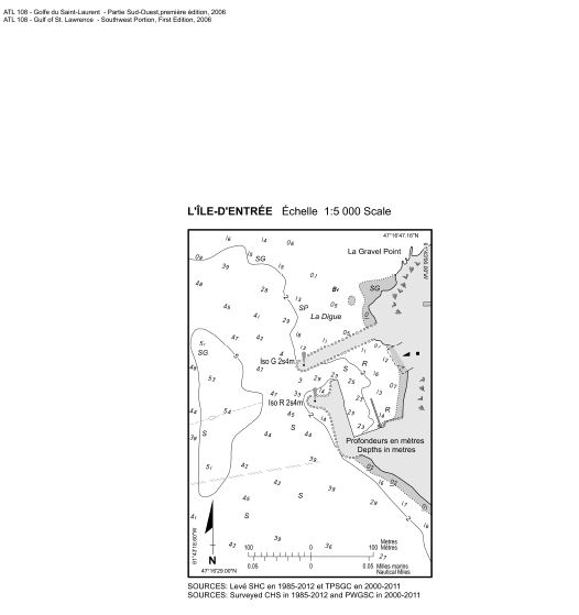
Replace the L'ÎLE-D'ENTRÉE diagram with the new one provided in Section 4 of this Monthly Edition.
L'ÎLE-D'ENTRÉE diagram - PDF format - http://www.notmar.gc.ca/eng/services/notmar/sec4oct12e.pdf or JPG format - http://www.notmar.gc.ca/eng/services/notmar/sec4oct12e.jpg
(Q2012-044.1)
Chapter 2 - In the vicinity of paragraph 101
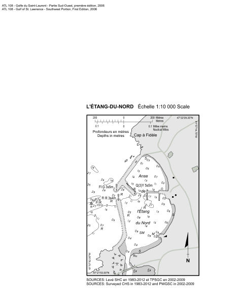
Replace the L'ÉTANG-DU-NORD diagram with the new one provided in Section 4 of this Monthly Edition.
L'ÉTANG-DU-NORD diagram - PDF format - http://www.notmar.gc.ca/eng/services/notmar/sec4oct12e2.pdf or JPG format - http://www.notmar.gc.ca/eng/services/notmar/sec4oct12e2.jpg
(Q2012-048.1)
Chapter 2 - In the vicinity of paragraph 112
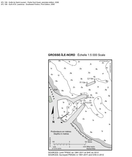
Replace the GROSSE-ÎLE-NORD diagram with the new one provided in Section 4 of this Monthly Edition.
GROSSE-ÎLE-NORD diagram - PDF format - http://www.notmar.gc.ca/eng/services/notmar/sec4oct12e1.pdf or JPG format - http://www.notmar.gc.ca/eng/services/notmar/sec4oct12e1.jpg
(Q2012-023.1)
Chapter 4 - Paragraph 266
Delete: "The public wharf ... on each side."
Replace by: The wharves are in ruins.
(Q2012-045.1)
Chapter 4 - Adjacent to paragraph 266, delete the wharf pictograph.
(Q2012-045.2)
ATL 110 - St. Lawrence River - Cap Whittle/Cap Gaspé to Les Escoumins and Anticosti Island, Third Edition, 2011 -
Chapter 3 - Paragraph 50
Delete: "Baie des Anglais is ... orange beacon on the point."
Replace by: Baie des Anglais is entered between Pointe Saint-Pancrace and Pointe Saint-Gilles, which is 4 miles to the SW.
(Q2012-054.1)
ATL 112 - St. Lawrence River - Cap-Rouge to Montréal and Rivière Richelieu, Third Edition, 2009 -
Chapter 1 - Paragraph 157
Delete: "It has a vertical clearance ... marked with lights."
Replace by: Red lights mark the limits of the main shipping channel which has a width of 225 m under the bridge and a vertical clearance of 48 m. A green light marks the centre of the main shipping channel where the vertical clearance is 49 m. The bridge is well marked with several other lights.
(Q2012-042.1)
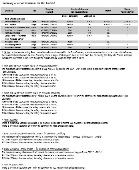
APPENDICE - Delete the Summary of air obstructions for this booklet Table (Re: Correction promulgated in Monthly Edition No. 7/2012) and replace by the new Summary of air obstructions for this booklet Table published in Section 4 of this Monthly Edition.
Summary of air obstructions booklet - PDF format - http://www.notmar.gc.ca/eng/services/notmar/sec4oct12e3.pdf or JPG format - http://www.notmar.gc.ca/eng/services/notmar/sec4oct12e3.jpg
(Q2012-042.2)
CEN 301 - St. Lawrence River, Montréal to Kingston, Second Edition, 2010 -
Chapter 5 - Paragraph 75, after "vertical clearance of"
Delete: 4.3 m
Replace by: 4.4 m
(C2012-075.01)
CEN 306 - Georgian Bay, First Edition, 1998 -
Chapter 3 - Paragraph 226, after "provided by the"
Delete: Boating Restriction Regulations
Replace by: Vessel Operation Restriction Regulations
(C2012-071.01)
Chapter 4 - Paragraph 57
Cancel correction promulgated in Monthly Edition No. 4/2011.
(C2012-071.02)
Chapter 4 - Paragraph 63, after "0.6 mile offshore."
Insert: A wreck, 0.3 mile NW of Hardhead Point, has a drying height of 0.8 m.
(C2012-071.03)
Chapter 4 - After paragraph 113
Insert: 113.1 There are four submerged cables extending from Cedar Point; two to Christian Island, one to Hope Island light and one across Thunder Bay to Thunder Point.
(C2012-071.04)
Chapter 4 - Paragraph 122, after "a depth of"
Delete: 4 feet (1.2 m)
Replace by: 5 feet (1.6 m)
(C2012-071.05)
Chapter 7 - Paragraph 89, after "limits under the"
Delete: Boating Restriction Regulations
Replace by: Vessel Operation Restriction Regulations
(C2012-071.06)
Chapter 10 - Paragraph 202, after "the south shore."
Insert: Sportsman's Inn is an authorised dealer of Canadian Hydrographic Service charts and publications.
(C2012-071.07)
CEN 307 - North Channel of Lake Huron, First Edition, 2000 -
Chapter 6 - Paragraph 154, after "overhead clearance of"
Delete: 12 m
Replace by: 13 m
(C2012-074.01)
Chapter 6 - Paragraph 154, after "the route is"
Delete: 2.8 m
Replace by: 2.7 m
(C2012-074.02)
Chapter 6 - Paragraph 166, after "a depth of"
Delete: 12.8 m
Replace by: 12.7 m
(C2012-074.03)
Chapter 6 - Paragraph 171, after "these rocks is"
Delete: 5.4 m
Replace by: 6 m
(C2012-074.04)
Chapter 6 - Paragraph 173, after "submerged power cable"
Delete: (not shown on Chart 2250)
(C2012-074.05)
Chapter 6 - Paragraph 178, after "a vertical clearance of"
Delete: 2.5 m
Replace by: 2.6 m
(C2012-074.06)
Chapter 6 - Paragraph 178, after "a clearance of"
Delete: 11 m
Replace by: 13 m
(C2012-074.07)
Chapter 6 - Paragraph 189, after "a depth of"
Delete: 0.7 m
Replace by: 0.6 m
(C2012-074.08)
Chapter 6 - Paragraph 209, after "navigation channel is"
Delete: 12 m
Replace by: 13 m
(C2012-074.09)
Chapter 6 - Paragraph 211, after "vertical clearance of"
Delete: 5.1 m
Replace by: 5.2 m
(C2012-074.10)
Chapter 6 - Paragraph 211, after "vertical clearance of"
Delete: 2.8 m
Replace by: 3.5 m
(C2012-074.11)
Chapter 6 - Paragraph 240, after "a depth of"
Delete: 1.4 m
Replace by: 1.3 m
(C2012-074.12)
Chapter 6 - Paragraph 247, after "a depth of"
Delete: 1.2 m
Replace by: 1.1 m
(C2012-074.13)
LIST OF LIGHTS, BUOYS AND FOG SIGNALS CORRECTIONS
NEWFOUNDLAND |
||||||||||
226.5 |
L'Anse au Clair Wharf |
51 25 24 57 04 01 |
Fl |
G |
4s |
4.9 |
4 |
Mast. 2.6 |
Seasonal. Chart:4470 Edn 10/12(N12-022) |
|
ATLANTIC |
||||||||||
632 |
Port Bickerton Fairway light and bell buoy V |
SW. of Taylor Shoal. 45 01 13 61 39 09 |
Mo(A) |
W |
6s |
..... |
..... |
Red and white vertical stripes, marked "V". |
Year round. Chart:4234 Edn 10/12 (G12-191) |
|
635 |
Isaac's Harbour Fairway light and whistle buoy TT |
E. of Jarvis Bank. 45 02 15 61 32 35 |
Mo(A) |
W |
6s |
..... |
..... |
Red and white vertical stripes, marked "TT". |
Year round. Chart:4234 Edn 10/12 (G12-192) |
|
670.5 |
Pas Reef light buoy PJ6 |
45 20 02.7 60 56 56.5 |
Fl |
R |
4s |
..... |
..... |
Red spar, marked "PJ6". |
Year round. Chart:4281 Edn 10/12 (G12-084) |
|
671 |
Grassy Island light buoy PJ12 |
S. of island. 45 19 58.3 60 58 10.7 |
Q |
R |
1s |
..... |
..... |
Red spar, marked "PJ12". |
Year round. Chart:4281 Edn 10/12 (G12-086) |
|
680.2 |
Hart Island light buoy PC6 |
NW. of island. 45 20 45.7 60 59 28.2 |
Q |
R |
1s |
..... |
..... |
Red spar, marked "PC6". |
Year round. Chart:4281 Edn 10/12 (G12-113) |
|
720 |
Marchant Ledge light buoy CJ18 |
W. side of inlet, on end of breakwater. 45 30 12.3 60 57 41.7 |
Fl |
R |
4s |
..... |
..... |
Red spar, marked "CJ18". |
Winter spar. Seasonal. Chart:4308 Edn 10/12 (G12-183) |
|
721 H3396 |
Petit-de-Grat Breakwater |
On outer end of breakwater at N. entrance to Petit-de-Grat Inlet. ??? 45 31 04.5 60 57 02.9 |
Fl |
G |
4s |
..... |
4 |
Square skeleton tower, 2 green and white rectangular daymarks. |
Flash 1 s; eclipse 3 s. Operates at night only. Seasonal. Chart:4308 Edn 10/12 |
|
925.12 |
Pugwash Harbour light and bell buoy UK |
Delete from list. Chart:4406 Edn 10/12 (G12-176) |
||||||||
1017.8 |
Seacow Head Information light buoy DC |
46 18 21.2 63 49 57.7 |
Fl |
Y |
4s |
..... |
..... |
Orange and white spar, marked "DC". |
Winter spar. Seasonal. Chart:4406 Edn 10/12 |
|
1017.9 |
Seacow Head Information light buoy DD |
46 18 45.2 63 49 25.7 |
Fl |
Y |
4s |
..... |
..... |
Orange and white spar, marked "DD". |
Winter spar. Seasonal. Chart:4406 Edn 10/12 |
|
1049.8 |
Grand Tracadie Wharf |
N. corner of wharf. 46 24 12.3 63 01 43.9 |
Fl |
R |
4s |
4.6 |
2 |
Cylindrical mast, red and white triangular daymark, red triangle in centre. 3.7 |
Flash 1 s; eclipse 3 s. Operates at night only. Seasonal. Chart:4425 Edn 10/12 (G12-182) |
|
1494.4 |
Havre-aux-Maisons light buoy YE6 |
47 23 37.8 61 50 18.6 |
Fl |
R |
4s |
..... |
..... |
Red, marked "YE6". |
Seasonal. Chart:4955 Edn 10/12 (Q12-122) |
|
1528.9 |
Île Greenly |
On SW part of island. 51 22 29.4 57 11 26.7 |
Fl |
W |
15s |
34.7 |
15 |
Skeleton tower. 22.3 |
Flash 0.5 s; eclipse 14.5 s. Operates at night only. Seasonal. The light of Île Greenly is obscured by Île au Bois through an arc of 015°, from 064° to 079°. Chart:4470 Edn 10/12 (Q12-130) |
|
1539.13 H1890.1 |
Île Mermettes Racon - - (M) X & S Band |
Centre of island. 51 19 20.5 57 50 34.6 |
Iso |
W |
2s |
11.8 |
6 |
Square skeleton tower. 6.5 |
Operates at night only. Year round. Chart:4471 Edn 10/12 (Q12/131) |
|
1716.5 |
Club nautique de Baie-Comeau light buoy KC1 |
49 13 42.3 68 07 43.2 |
Fl |
G |
3s |
..... |
..... |
Green, marked "KC1". |
Privately maintained by le Club Nautique de Baie-Comea. Seasonal. Chart:1226 Edn 10/12 (Q12-119) |
|
1716.8 |
Club nautique de Baie-Comeau light buoy KC3 |
49 13 40.9 68 08 01.1 |
Fl |
G |
3s |
..... |
..... |
Green, marked "KC3". |
Privately maintained by le Club Nautique de Baie-Comeau. Seasonal. Chart:1226 Edn 10/12 (Q12-120) |
|
1747 |
Pointe à Boisvert light buoy K48 |
SE. of the point. 48 33 00.1 69 07 18.2 |
Fl |
R |
4s |
..... |
..... |
Red, marked "K48". |
Seasonal. Chart:1236 Edn 10/12 (Q12-123) |
|
1752 |
Cap à la Carre North Cardinal light buoy CALR |
N. of shoal. 48 19 57.1 69 00 55.1 |
Q |
W |
1s |
..... |
..... |
Black and yellow, marked "CALR". |
Seasonal. Chart:1320 Edn 10/12 (Q12-125) |
|
2361 H2497 2362 H2497.1 |
Traverse Longue-Pointe range |
| | | | | | | | | |
45 33 42.5 73 29 41.3 169°48' 190m from front. |
Iso Iso |
W W |
2s 2s |
14.0 20.6 |
18 18 |
White cylindrical tower, orange daymark, black vertical stripe. 8.9 White cylindrical tower, orange slatwork daymark, black vertical stripe. 13.3 |
Visible in line of range. Year round. Visible in line of range. Year round. Chart:1310 Edn 10/12 (Q12-124) |
2365.91 |
Light buoy MT79 |
45 32 38.1 73 31 21.7 |
Fl |
G |
4s |
..... |
..... |
Green, marked "MT79". |
Seasonal. Chart:1310 Edn 10/12 (Q12-126) |
|
2365.93 |
Light buoy MT81 |
45 32 26.8 73 31 26.6 |
Fl |
G |
4s |
..... |
..... |
Green, marked "MT81". |
Seasonal. Chart:1310 Edn 10/12 (Q12-127) |
|
Inland LL 2503 |
Pullen Island Racon - - . (G) X & S Band |
On island, Kugmallit Bay. 69 46 26.2 134 24 15.7 |
Fl |
W |
6s |
41.0 |
7 |
Tripod skeleton tower, white daymark, red vertical stripe. 9.1 |
Flash 0.5 s; eclipse 5.5 s. Radar reflector. Seasonal. Chart:7663 Edn 10/12 (A12-007) |
|
INLAND WATERS |
||||||||||
39 |
Light buoy C6 |
45 16 06.6 73 57 12.1 |
Q |
R |
1s |
..... |
..... |
Red, marked "C6". |
Seasonal. (In place Year round.) Chart:1431 Edn 10/12(B12-023) |
|
709.8 |
Light buoy 30 (U.S.) |
Delete from list. Chart:14853(U.S.) Edn 10/12(B12-013) |
||||||||
709.8 |
Lake St. Clair light buoy 30 (U.S.) |
42 30 30.7 82 41 54.5 |
Q |
R |
1s |
..... |
..... |
Red, marked "30". |
Year round. Chart:14852(U.S.) Edn 10/12(B12-014) |
|
2503 |
Pullen Island Racon - - . (G) X & S Bands |
On island in Kugmallit Bay. 69 46 26.2 134 24 15.7 |
Fl |
W |
6s |
41.0 |
7 |
Tripod skeleton tower, white daymark, red vertical stripe. 9.1 |
Flash 0.5 s; eclipse 5.5 s. Radar reflector. Seasonal. Chart:7663 Edn 10/12(A12-007) |
|

