The Standard on Web Usability replaces this content. This content is archived because Common Look and Feel 2.0 Standards have been rescinded.
Archived information is provided for reference, research or recordkeeping purposes. It is not subject to the Government of Canada Web Standards and has not been altered or updated since it was archived.
Sailing Directions and Small Craft Guide Corrections
46 - 50
Section 5
List of Lights, Buoys and Fog signals Corrections
51, 52
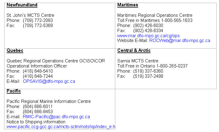
Maritime Services Directorate
Aids to Navigation
Internet: www.notmar.gc.ca
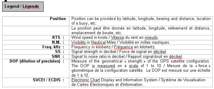
EXPLANATORY NOTES
Geographical positions refer directly to the graduations of the largest scale Canadian Hydrographic chart unless otherwise indicated.
Bearingsrefer to the true compass and are measured clockwise from 000° (North) clockwise to 359°; those relating to lights are from seaward.
Visibility of lights is that in clear weather.
Depths - The units used for soundings (metres, fathoms or feet) are stated in the title of each chart.
Elevationsare normally given above Higher High Water, Large Tides unless otherwise indicated.
Distances may be calculated as follows:
1 nautical mile = 1 852 metres (6,076.1 feet)
1 statute mile = 1 609.3 metres (5,280 feet)
1 metre = 3.28 feet
Temporary & Preliminary Notices are indicated by a (T) or a (P) before the chart action. Please note that Nautical charts are not hand amended by the Canadian Hydrographic Service for Temporary (T) and Preliminary (P) Notices. It is recommended that mariners chart these corrections in pencil. Listing of charts affected by Temporary and Preliminary Notices are revised and promulgated quarterly in Section 1 of the Monthly Edition.
Please note that, in addition to the temporary and preliminary changes normally advertised as (T) and (P) Notices, there are a significant number of permanent changes to navigational aids that have been advertised as Preliminary Notices to Mariners while charts are being updated for new editions.
Marine Information Report & Suggestion Sheet- Mariners are requested to notify the responsible authorities when new or suspected dangers to navigation are discovered, changes observed in aids to navigation or corrections to publications are seen to be necessary. Such communications can be made using the Marine Information Report & Suggestion Sheet inserted on the last pageof each monthly edition of Notices to Mariners.
Monthly edition of Notices to Mariners - Notices to Mariners are issued free of charge on a monthly basis. Mariners now have a choice between specific Regional issue(s) they wish to receive. Requests to be placed on or removed from the mailing list should be made by using the form inserted on page vi of each monthly edition. Notification of changes to the mailing addresses, regional issues and/or number of copies required should also be transmitted by means of this form.
Canadian Nautical Charts & Publications - A source list of Canadian Nautical Charts & publications is published in Notice No. 14 of the current Annual Edition of Notices to Mariners. The source supply and the prices effective at the time of printing are listed. This list is periodically updated in the monthly edition of Notices to Mariners.
NOTE: Cette publication est aussi disponible en français.
CHART CORRECTIONS - SECTION 2
Corrections to nautical charts will be listed in numeric order by chart number. Each chart correction listed applies only to that particular chart. Related charts, if any, will have their own specific correction listed separately. Users should also refer to CHS Chart 1 Symbols, Abbreviations Terms for additional information pertaining to the correction of charts. The illustration below describes the elements that will comprise a typical Section 2 chart correction.
ADVISORY
NOTICES TO SHIPPING (WRITTEN AND BROADCAST)
The Canadian Coast Guard is implementing a number of changes to the aids to navigation system in Canada.
These changes are advertised as Notices to Shipping (Broadcast and Written) by the Canadian Coast Guard and are followed up with Notices to Mariners, then charts are updated by hand correction, reprints or new editions.
Mariners are advised that all relevant Written Notices to Shipping should be kept until superseded by Notices to Mariners or through revised charts issued by the Canadian Hydrographic Service.
Written Notices to Shipping are published weekly and are available from local Canadian Coast Guard Offices.
The Canadian Hydrographic Service is reviewing the impact of these changes with the Canadian Coast Guard and together we are preparing an action plan on the issuing of chart revisions.
For further information contact your local Canadian Coast Guard office.
DGPS FULLY OPERATIONAL SERVICE
The Canadian Coast Guard (CCG) announces that the Differential Global Positioning Service (DGPS) Fully Operational Service (FOS) is available for positioning and navigation.
FOS means the service will provide a DGPS broadcast using the type 9 RTCM message for pseudorange corrections at a data transmission rate of 200 baud. Refer to Radio Aids to Marine Navigation (RAMN) for estimated advertised coverage for each differential station.
Users are also advised that differential corrections are based on the NAD 83 datum position of the reference station antenna and positions obtained using DGPS should be referenced to this coordinate system only. DGPS receivers must be set to the WGS 84 datum in order to obtain optimum positioning accuracy.
Table of DGPS Reference Stations in Canada
Station Name
Id. Nos
ofreference
stations
DGPS
Station
ID
Geog. Position
Frequency [kHz]
Bit/s
Latitude
Longitude
Cape Race, NL
338,339
940
46 46 N
53 11 W
315
200
Cape Ray, NL
340,341
942
47 38 N
59 14 W
288
200
Cape Norman, NL
342,343
944
51 30 N
55 49 W
310
200
Rigolet, NL
344,345
946
54 11 N
58 27 W
299
200
Partridge Island, NB
326,327
939
45 14 N
66 03 W
295
200
Pt. Escuminac, NB
332,333
936
47 04 N
64 48 W
319
200
Fox Island, NS
336,337
934
45 20 N
61 05 W
307
200
Western Head, NS
334,335
935
43 59 N
64 40 W
312
200
Hartlen Point, NS
330,331
937
44 36 N
63 27 W
298
200
St.-Jean-sur-Richelieu, QC
312,313
929
45 19 N
73 19 W
296
200
Lauzon, QC
316,317
927
46 49 N
71 10 W
309
200
Rivière-du-Loup, QC
318,319
926
47 46 N
69 36 W
300
200
Moisie, QC
320,321
925
50 12 N
66 07 W
313
200
Wiarton, ON
310,311
918
44 45 N
81 07 W
286
200
Cardinal, ON
308,309
919
44 47 N
75 25 W
306
200
Alert Bay, BC
300,301
909
50 35 N
126 55 W
309
200
Amphitrite Pt., BC
302,303
908
48 55 N
125 33 W
315
200
Richmond, BC
304,305
907
49 11 N
123 07 W
320
200
Sandspit, BC
306,307
906
53 14 N
131 49 W
300
200
DGPS RECEIVER - WARNING
The Canadian Coast Guard's Differential Global Positioning System (DGPS) broadcast contains built in health information designed to alert a DGPS user receiver of an out of tolerance or fault condition. During testing, it was found that some user DGPS receivers did not process the health information properly. Improper processing by a user equipment can result in incorrect positions.
Please contact your DGPS manufacturer or supplier to ensure that your receiver is capable of processing the DGPS Reference Station Health information correctly.
DGPS USER ALERT
The Canadian Coast Guard received reports in March 97 of DGPS receivers apparently ignoring the broadcast alarm which should signal the immediate discontinuation of a particular satellite correction. Reports indicate that some user equipment does not properly recognize this "do-not-use" correction flag and as a result erroneously processes it as a correction. This can result in position errors as large as 15 kilometers while the receiver is in DGPS mode. DGPS users are advised that they should contact the manufacturer of their equipment immediately to determine if they require a receiver upgrade.
DGPS station anomaly report / Rapport d'anomalie des stations DGPS
With the purpose of constantly evaluating the quality of the DGPS service offered, the Canadian Coast Guard is providing the mariner with the following anomaly report. This report will allow us to get well-supported information concerning the anomaly and thus, will facilitate the identification of the origin of the problem. Please fill accordingly each section of this report and forward it by the suggested ways. You will find a legend at the end of this document.
Avec le souci d'évaluer constamment la qualité du service DGPS offert, la Garde côtière met à la disposition du navigateur le présent rapport d'anomalie. Ce rapport servira à bien documenter l'anomalie et, de ce fait, facilitera l'identification ou la recherche de la source du problème. Nous vous prions de bien remplir chaque section de ce rapport et de l'acheminer de la façon suggérée. Vous trouverez une légende à la fin de ce document.
MONTHLY EDITION OF NOTICES TO MARINERS
MAILING LIST CHANGES
Leader, Notices to Mariners
Navigation Aids
Navigation Systems
Canadian Coast Guard
200 Kent Street, Station 5N186
Ottawa, ON
K1A 0E6
Telephone (613) 990-3037
Facsimile (613) 998-8428
Internet www.notmar.gc.ca
Please indicate which edition you would like to receive.
EASTERN EDITION (Comprised of Arctic, Newfoundland, Maritimes, Gulf & River St. Lawrence and Central areas) ________
WESTERN EDITION (Comprised of Arctic and Pacific areas)________
ADD _____AMEND ______REMOVE ______NO. OF COPIES ___________
INDEX
CANADIAN HYDROGRAPHIC SERVICE - ANNOUNCEMENT REGARDING CANADIAN HYDROGRAPHIC SERVICE CHART PATCHES
1
CANADIAN HYDROGRAPHIC SERVICE - ARCTIC CHARTS
2
CANADIAN HYDROGRAPHIC SERVICE - CUMULATIVE CHART CORRECTIONS
1
CANADIAN HYDROGRAPHIC SERVICE - Current chart edition dates
1
CANADIAN HYDROGRAPHIC SERVICE - NOTICES TO MARINERS QUESTIONNAIRE
2
CANADIAN HYDROGRAPHIC SERVICE - PRINT ON DEMAND CHARTS - CARE AND USE
1
*410(T) CANADA - Safety of offshore exploration and exploitation vessels
4
*404 CANADIAN COAST GUARD - LIST OF CHARTS AND REFERENCE CHARTS (SECTION I) AFFECTED BY TEMPORARY AND PRELIMINARY NOTICES
5
*409 canadian coast guard publication - new edition of the annual edition of notices to MARINERS - 2007
7
*407 CANADIAN COAST GUARD PUBLICATION - new edition of THE RADIO AIDS TO MARINE NAVIGATION (atlantic, st. lawrence, great lakes, lake winnipeg and eastern arctic) publication - 2007
6
*405 CANADIAN COAST GUARD PUBLICATION - new edition of THE PACIFIC LIST OF LIGHTS, BUOYS AND FOG SIGNALS - 2007
6
*401 CANADIAN HYDROGRAPHIC SERVICE - Nautical Charts
3
*402 CANADIAN HYDROGRAPHIC SERVICE - Electronic Navigation Charts
3
*403 CANADIAN HYDROGRAPHIC SERVICE - Raster Navigation Charts
4
*412 Lac Saint-Louis - buoys privatised
7
*411(P) Sydney Harbour - fog signal TO BE DISCONTINUED
7
NUMERICAL INDEX OF CANADIAN CHARTS AFFECTED
Chart No.
Page
Chart No.
Page
Chart No.
Page
1313
3
L/C4952
3
6429
35
1315
8
4954
19
6430
35, 36
1316
8, 9
4955
19
6431
36
1317
9
4956
19
6432
3, 37
1410
10, 11
4957
19, 20
6433
37, 38
1510
11, 12
6241
20
6435
38
2023
12, 13
6310
20
6436
39
L/C2110
13
6311
20
6437
39, 40
L/C2201
14
6408
20, 21
6438
40
2259
14
6409
21
6441
41
2268
14
6410
22
6451
41, 42
L/C2282
14
6411
3, 22, 23
6452
43
2283
14
6412
23, 24
6453
43, 44
2299
15 15
6413
24
6454
44
L/C4002
15
6414
25
6455
45
4003
15
6415
25, 26
7750
3
4020
15, 16
6416
26, 27
8049
45
4024
16, 17
6417
27
4201
17
6418
27, 28
4211
17
6419
3, 28
4237
11
6420
29
4241
17
6421
3, 29, 30
L/C4320
17
6422
3, 30
4385
17
6423
3, 31
4617
18
6424
3, 31, 32
4731
18
6425
3, 32
4921
18, 19
6426
33
4950
3
6427
3, 33, 34
L/C4951
3
6428
3, 34
SECTION 1 – Edition 04/2007
SAFETY AND GENERAL INFORMATION
CANADIAN HYDROGRAPHIC SERVICE - ANNOUNCEMENT REGARDING CANADIAN HYDROGRAPHIC SERVICE CHART PATCHES.
CHS is introducing a new initiative with a full colour Patch on the Web. A link in the Notices to Mariners web site will be provided so clients can access the colour Patch. The colour Patch will be published in HTML and PDF format. Providing the Patches in colour (accessible to all via remote access to the Web) is an enhanced form of alternative service delivery in line with CHS strategic objectives.
Colour Web Patches are free to the mariner, and given the quality of many printers, should reproduce well. They will be available in real time all around the world which is an improvement since clients had to wait for the paper copy to be mailed.
Previously, in the Notices to Mariners (NTM) booklet, Patches were produced in full colour or a minimum of black and magenta.
Due to current budgetary constraints, Patches will now only be produced in black and white for publication in the NTM booklet.
Our level of service will change with this initiative and CHS intends to analyze market reaction to this innovation.
CHS welcomes your feedback on this new service at chsinfo@dfo-mpo.gc.ca
CANADIAN HYDROGRAPHIC SERVICE - CUMULATIVE CHART CORRECTIONS.
The cumulative Notice to Mariners corrections for charts can now be accessed at http://www.notmar.gc.ca/search/notmar_e.php
CANADIAN HYDROGRAPHIC SERVICE - CURRENT CHART EDITION DATES.
CHART EDITIONS
The three terms described below are used to indicate the publication status of Canadian charts.
NEW CHART - "NEWCHT"
The first publication of a Canadian chart embracing an area not previously charted to the scale shown, or embracing an area different from any existing Canadian chart.
NEW EDITION - "NEWEDT"
A new issue of an existing chart containing amendments essential to navigation in addition to those issued in Notice to Mariners and making existing editions obsolete.
REPRINTS
A new issue of the current edition of a chart incorporating no amendments of navigational significance other than those previously promulgated in Notice to Mariners. It may also contain amendments from other sources provided they are not essential to navigation. Previous printings of the current edition remain in force.
The current chart edition dates can now be accessed at http://www.chs-shc.gc.ca/pub/en/products/core.cfm
CANADIAN HYDROGRAPHIC SERVICE - PRINT ON DEMAND CHARTS - CARE AND USE.
Background
By providing nautical charts to the public, the goal of the Canadian Hydrographic Service (CHS) is to provide services for safe navigation in a fiscally responsible manner. As a result, CHS continues to expand its portfolio of nautical paper charts that are printed using Print On Demand (POD) technology. These charts are easily recognized by their whiter paper and the coloured logo of the Canadian Hydrographic Service. This new technology enables CHS to print charts in a more efficient manner while enhancing chart content through being able to quickly add new and important information. POD technology provides customers with up-to-date charts without the historical hand-drawn corrections or glued-on patches. Additionally, this technology eliminates out-of-stock situations which arise with the traditional printing and warehousing methods. In the event of a national emergency, CHS can respond to the appropriate authorities with best available information very quickly.
Care of Your POD Chart
CHS encourages its customers to handle the POD charts more carefully than the traditional lithographic charts. When plotting information on POD charts, use HB pencils and apply limited pressure. Testing has suggested that an Indian gum eraser is more effective than alternatives when used on the product. This eraser is also suitable for charts printed using lithographic processes.
CANADIAN HYDROGRAPHIC SERVICE - NOTICES TO MARINERS QUESTIONNAIRE.
The Canadian Hydrographic Service is studying the possibility of providing more Section 2 Notices to Mariners for paper charts in the graphic form, and is requesting your input. We have identified three possible methods that we would like you to consider when you complete the questionnaire. The questionnaire can be found by clicking on the following web address, or pasting it into your browser:
The completed questionnaire results are sent by clicking on the "submit" button.
Information you provide is held in strict confidence, and helps us determine our products and services. The Canadian Hydrographic Service does not distribute email addresses to any persons outside of CHS.
If you wish to be removed from our mailing list, please send a reply to me at the address below.
Fisheries and Oceans Canada | 9860 West Saanich Road Sidney, BC V8L 4B2
Government of Canada
CANADIAN HYDROGRAPHIC SERVICE - ARCTIC CHARTS.
Please be advised that effective February 2007 all Arctic notices will appear in both the Eastern and Western paper editions of Notices to Mariners.
Mariners may obtain all Arctic chart notices via the Canadian Coast Guard Notices to Mariners online service www.notmar.gc.ca or by contacting the Canadian Coast Guard, Notices to Mariners office at the following coordinates:
Leader, Notices to Mariners
Aids to Navigation
Navigation Systems
Canadian Coast Guard
200 Kent Street, Station 5N186
Ottawa, ON
K1A 0E6
Telephone (613) 993-6974
Facsimile (613) 998-8428
*401 CANADIAN HYDROGRAPHIC SERVICE - NAUTICAL CHARTS.
CHARTS
MAIN TITLE
SCALE
PUBLISHED
CAT#
PRICE
New Edition
All temporary and preliminary notices affecting the previous versions of the following chart(s) (is / are) now cancelled. For any outstanding notices please consult section 2 of this edition.
1313
Batiscan au/to Lac Saint-Pierre
1:40000
02-FEB-2007
1
$20.00
3312
Jervis Inlet & Desolation Sound and Adjacent Waterways/et les voies navigables adjacentes
Approaches to/Approches à Portland Inlet (Western Portion, Part 1 of 2)
CA376230
Cape Canso to Liscomb Island
*403 CANADIAN HYDROGRAPHIC SERVICE - RASTER NAVIGATION CHARTS.
CHARTS
MAIN TITLE
New Edition
All temporary and preliminary notices affecting the previous versions of the following chart(s) (is / are) now cancelled. For any outstanding notices please consult section 2 of this edition.
Plans- Vicinity of/proximité de - Pitt Island and/et Banks Island
22-SEP-2006
See Note 2
R/M3761
Kitkatla Inlet
17-NOV-2006
See Note 2
R/M3825
Cape St. James to/à Houston Stewart Channel
22-SEP-2006
See Note 2
Charts Permanently Withdrawn
R/M4951
Îles de la Madeleine - Partie sud/South Portion
R/M4952
Îles de la Madeleine - Partie nord/Northern Portion
*410(T) CANADA - SAFETY OF OFFSHORE EXPLORATION AND EXPLOITATION VESSELS.
Reference: Notice 708(T)/2006 is cancelled.
2007 Annual Edition of Notices to Mariners, Notice No. 20, pages A20-1 to A20-XX.
Mariners are advised that offshore exploration and exploitation vessels may be conducting drilling operations in the following areas:
Gulf of St. Lawrence
NIL
Mainland NWT
NIL
Mackenzie Delta NWT/Beaufort Sea
NIL
Arctic Islands of the NWT/Arctic Islands of Nunavut
NIL
Eastern Arctic Offshore
NIL
Davis Strait
NIL
NOTE: Mariners are advised to obtain up-to-date position reports on drilling vessels and production installations before entering an area of exploration and exploitation. This information is available by contacting, as appropriate, ECAREG CANADA, NORDREG CANADA or CVTS OFFSHORE via any Marine Communications and Traffic Services Centre (MCTS).
(NEB)
*404 CANADIAN COAST GUARD - LIST OF CHARTS AND REFERENCE CHARTS (SECTION I) AFFECTED BY TEMPORARY AND PRELIMINARY NOTICES.
*405 CANADIAN COAST GUARD PUBLICATION - NEW EDITION OF PACIFIC LIST OF LIGHTS, BUOYS AND FOG SIGNALS - 2007.
The 2007 edition of the Pacific List of Lights, Buoys and Fog Signals has been published. Information contained in Notices to Mariners up to and including Monthly Edition No. 3 of 2007 has been embodied in this publication. The price of this publication is $14.95.
This publication is available through authorized Canadian Hydrographic Service Chart dealers. A complete listing of authorized CHS chart dealers is available at the following Internet address: http://charts.gc.ca
This publication can also be downloaded from the Notices to Mariners Internet site at http://notmar.gc.ca
*407 CANADIAN COAST GUARD PUBLICATION - NEW EDITION OF THE RADIO AIDS TO MARINE NAVIGATION(ATLANTIC, ST. LAWRENCE, GREAT LAKES, LAKE WINNIPEG AND EASTERN ARCTIC) PUBLICATION - 2007.
The 2007 edition of the Radio aids to marine navigation (Atlantic, St. Lawrence, Great Lakes, Lake Winnipeg and Eastern Arctic) has been published. Information contained in Notices to Mariners section 3 up to and including Monthly Edition No. 12 of 2006 has been embodied in this publication. The price of this publication is $ 18.95.
This publication is available through authorized Canadian Hydrographic Service Chart dealers. A complete listing of authorized CHS chart dealers is available at the following Internet address: http://charts.gc.ca
This publication can also be downloaded from Marine Communications and Traffic Services Internet site at http://ccg-gcc.ncr.dfo-mpo.gc.ca/mcts-sctm/ramn/index_e.htm
*409 CANADIAN COAST GUARD PUBLICATION - NEW EDITION OF THE ANNUAL EDITION OF NOTICES TOMARINERS - 2007.
The new edition of the Annual Edition of Notices to Mariners for the year 2007 is now available at a cost of $22.95.
This publication is available through authorized Canadian Hydrographic Service Chart Dealers. A complete listing of authorized CHS chart dealers is available at the following Internet address: http://www.charts.gc.ca
This publication can also be downloaded from the Notices to Mariners Internet site at http://www.notmar.gc.ca
*411(P) SYDNEY HARBOUR - FOG SIGNAL TO BE DISCONTINUED.
Reference chart: 4266
The Canadian Coast Guard intends to permanently discontinue the following aid to navigation:
Low Point Fog Signal LL.775 (46° 16' 01.5" N 60° 07' 32.9" W).
Comments on this action are solicited from mariners and other interested parties. Comments should be directed to Glen Graham, Superintendent, Aids to Navigation, Canadian Coast Guard, P.O. Box 1000, Dartmouth, NS
B2Y 3Z8, Tel: (902) 426-3151, E-mail: GrahamG@mar.dfo-mpo.gc.ca , within three months from the date of this Notice. Any objections raised must state the facts on which they are based and should include supporting information on safety, commerce and public benefit.
(G2007-0013)
*412 LAC SAINT-LOUIS - BUOYS PRIVATISED.
Reference chart: 1410
The following un-lighted buoys are now private and have been transferred to the city of Beauharnois.
1315 - Québec à/to Donnacona - New Edition - 21-JUN-2002 - NAD 1983
13-APR-2007
LNM/D. 23-MAR-2007
Delete
depth of 14 metres 9 decimetres
46°49'36.8"N 071°11'43.4"W
DFO(6407426-01)
Delete
depth of 16 metres 0 decimetre
46°49'33.9"N 071°11'29.6"W
DFO(6407426-03)
Add
depth of 14 metres 1 decimetre
46°49'36.8"N 071°11'44.1"W
DFO(6407426-02)
Add
depth of 15 metres 1 decimetre
46°49'34.8"N 071°11'30.0"W
DFO(6407426-04)
Add
depth of 14 metres 7 decimetres
46°49'40.4"N 071°11'36.0"W
DFO(6407426-18)
1316 - Port de Québec - New Edition - 23-JUN-2006 - NAD 1983
13-APR-2007
LNM/D. 23-MAR-2007
Delete
depth of 14 metres 9 decimetres
46°49'36.9"N 071°11'44.1"W
DFO(6407426-01)
Delete
depth of 16 metres 0 decimetre
46°49'33.3"N 071°11'30.4"W
DFO(6407426-03)
Delete
depth of 9 metres 8 decimetres
46°49'20.0"N 071°12'34.9"W
DFO(6407426-05)
Delete
depth of 11 metres 6 decimetres
46°49'22.4"N 071°12'01.0"W
DFO(6407426-07)
Delete
depth of 14 metres 8 decimetres
46°49'28.4"N 071°12'04.7"W
DFO(6407426-09)
Delete
depth of 17 metres 2 decimetres
46°49'35.4"N 071°11'59.6"W
DFO(6407426-11)
Delete
depth of 12 metres 8 decimetres
46°49'34.0"N 071°11'51.6"W
DFO(6407426-13)
Delete
depth of 15 metres 2 decimetres
46°49'38.9"N 071°11'36.9"W
DFO(6407426-17)
Delete
depth of 17 metres 0 decimetre
46°50'00.2"N 071°11'18.4"W
DFO(6407426-19)
Delete
depth of 5 metres 2 decimetres
46°50'08.9"N 071°11'10.8"W
DFO(6407426-21)
Add
depth of 14 metres 1 decimetre
46°49'36.8"N 071°11'44.1"W
DFO(6407426-02)
Add
depth of 15 metres 1 decimetre
46°49'34.8"N 071°11'30.0"W
DFO(6407426-04)
Add
depth of 9 metres 3 decimetres
46°49'19.8"N 071°12'34.1"W
DFO(6407426-06)
Add
depth of 11 metres 2 decimetres
46°49'22.0"N 071°12'01.7"W
DFO(6407426-08)
Add
depth of 13 metres 0 decimetre
46°49'28.0"N 071°12'05.2"W
DFO(6407426-10)
Add
depth of 14 metres 2 decimetres
46°49'35.9"N 071°11'59.5"W
DFO(6407426-12)
Add
depth of 12 metres 1 decimetre
46°49'33.9"N 071°11'49.9"W
DFO(6407426-14)
Add
depth of 13 metres 9 decimetres
46°49'39.5"N 071°11'51.4"W
DFO(6407426-16)
Add
depth of 14 metres 7 decimetres
46°49'40.4"N 071°11'36.0"W
DFO(6407426-18)
Add
depth of 12 metres 8 decimetres
46°50'00.4"N 071°11'19.2"W
DFO(6407426-20)
Add
depth of 4 metres 4 decimetres
46°50'08.9"N 071°11'09.5"W
DFO(6407426-22)
Add
depth of 7 metres 8 decimetres
46°50'04.3"N 071°11'20.8"W
DFO(6407426-23)
1317 - Continuation A - New Edition - 17-AUG-2001 - NAD 1983
13-APR-2007
LNM/D. 30-MAR-2007
Delete
depth of 14 metres 9 decimetres
46°49'36.6"N 071°11'44.5"W
DFO(6407426-01)
Delete
depth of 16 metres 0 decimetre
46°49'33.5"N 071°11'30.7"W
DFO(6407426-03)
Amend
legend F G 50m 18M to read F G 76m 18M against light
46°58'03.7"N 070°58'11.4"W
(Q2007010) LL(1942) DFO(6407425-01)
Add
depth of 14 metres 1 decimetre
46°49'36.8"N 071°11'44.1"W
DFO(6407426-02)
Add
depth of 15 metres 1 decimetre
46°49'34.8"N 071°11'30.0"W
DFO(6407426-04)
Add
depth of 14 metres 7 decimetres
46°49'40.4"N 071°11'36.0"W
DFO(6407426-18)
Add
depth of 13 metres 9 decimetres
46°49'30.6"N 071°11'38.5"W
DFO(6407426-24)
1410 - Lac Saint-Louis - New Edition - 26-APR-2002 - NAD 1983
06-APR-2007
LNM/D. 23-MAR-2007
Delete
depth of 4 feet
45°21'23.5"N 073°59'13.4"W
DFO(6407435-09)
Delete
depth of 5 feet
45°21'19.7"N 073°59'10.4"W
DFO(6407435-10)
Delete
depth of 5 feet
45°21'20.2"N 073°59'03.7"W
DFO(6407435-11)
Delete
depth of 1 foot
45°21'17.5"N 073°59'04.8"W
DFO(6407435-12)
Delete
depth of 8 feet
45°21'14.2"N 073°59'01.9"W
DFO(6407435-13)
Delete
depth of 7 feet
45°20'32.9"N 073°57'54.1"W
DFO(6407435-14)
Delete
depth of 8 feet
45°20'28.8"N 073°57'42.4"W
DFO(6407435-15)
Delete
depth of 7 feet
45°20'13.0"N 073°57'38.8"W
DFO(6407435-16)
Delete
depth of 4 feet
45°21'23.9"N 073°48'09.6"W
DFO(6407443-02)
Amend
legend 4 ft (1969) to read 3 ft (2006)
45°21'53.1"N 073°48'48.1"W
DFO(6407443-03)
Add
depth of 1 foot
45°21'23.8"N 073°59'14.2"W
DFO(6407435-01)
Add
depth of 3 feet
45°21'20.3"N 073°59'11.5"W
DFO(6407435-02)
Add
depth of 2 feet
45°21'18.8"N 073°59'04.8"W
DFO(6407435-03)
Add
depth of 4 feet
45°21'13.2"N 073°59'01.6"W
DFO(6407435-04)
Add
depth of 3 feet
45°20'32.6"N 073°57'55.2"W
DFO(6407435-05)
Add
depth of 6 feet
45°20'28.6"N 073°57'40.9"W
DFO(6407435-06)
Add
depth of 2 feet
45°20'12.8"N 073°57'37.5"W
DFO(6407435-07)
Add
depth of 4 feet
45°20'10.3"N 073°57'42.9"W
DFO(6407435-08)
Add
water intake
between 45°25'44.7"N 073°49'14.6"W
and 45°25'38.6"N 073°49'09.4"W
DFO(6407440-01)
Add
depth of 3 feet over the intake
45°25'38.6"N 073°49'09.4"W
DFO(6407440-02)
Add
depth of 1 foot
45°25'32.4"N 073°49'10.4"W
DFO(6407440-03)
Add
drying height of 0 feet
45°19'04.2"N 073°52'37.9"W
DFO(6407441-01)
Add
depth of 2 feet
45°21'24.6"N 073°48'09.3"W
DFO(6407443-01)
13-APR-2007
LNM/D. 06-APR-2007
Delete
depth of 6 feet
45°23'37.4"N 073°45'03.9"W
DFO(6407437-05)
Add
depth of 7 feet
45°24'55.4"N 073°51'25.9"W
DFO(6407436-01)
Add
depth of 4 feet
45°23'49.1"N 073°45'06.8"W
DFO(6407437-01)
Add
depth of 1 foot
45°23'36.8"N 073°45'04.0"W
DFO(6407437-02)
Add
depth of 4 feet
45°23'15.6"N 073°44'51.4"W
DFO(6407437-03)
Add
depth of 3 feet
45°22'56.0"N 073°45'01.9"W
DFO(6407437-04)
Add
depth of 5 feet
45°21'58.0"N 073°50'39.3"W
DFO(6407438-01)
Add
depth of 7 feet
45°24'10.5"N 073°46'12.6"W
DFO(6407439-01)
1510 - Lac Saint-Louis à/to Carillon - Compartment B-C - Sheet 1 - New Edition - 25-JUL-2003 - NAD 1983
06-APR-2007
LNM/D. 22-SEP-2006
Delete
depth of 1 metre 2 decimetres
45°21'23.5"N 073°59'13.4"W
DFO(6407435-09)
Delete
depth of 1 metre 5 decimetres
45°21'19.7"N 073°59'10.4"W
DFO(6407435-10)
Delete
depth of 1 metre 5 decimetres
45°21'20.2"N 073°59'03.7"W
DFO(6407435-11)
Delete
depth of 0 metre 3 decimetres
45°21'17.5"N 073°59'04.8"W
DFO(6407435-12)
Delete
depth of 2 metres 4 decimetres
45°21'14.2"N 073°59'01.9"W
DFO(6407435-13)
Delete
depth of 2 metres 1 decimetres
45°20'32.9"N 073°57'54.1"W
DFO(6407435-14)
Delete
depth of 2 metres 4 decimetres
45°20'28.8"N 073°57'42.4"W
DFO(6407435-15)
Delete
depth of 2 metres 1 decimetres
45°20'13.0"N 073°57'38.8"W
DFO(6407435-16)
Add
depth of 0 metre 3 decimetres
45°21'23.8"N 073°59'14.2"W
DFO(6407435-01)
Add
depth of 1 metre
45°21'20.3"N 073°59'11.5"W
DFO(6407435-02)
Add
depth of 0 metre 6 decimetres
45°21'18.8"N 073°59'04.8"W
DFO(6407435-03)
Add
depth of 1 metre 1 decimetre
45°21'13.2"N 073°59'01.6"W
DFO(6407435-04)
Add
depth of 1 metre
45°20'32.6"N 073°57'55.2"W
DFO(6407435-05)
Add
depth of 1 metre 9 decimetres
45°20'28.6"N 073°57'40.9"W
DFO(6407435-06)
Add
depth of 0 metre 6 decimetres
45°20'12.8"N 073°57'37.5"W
DFO(6407435-07)
Add
depth of 1 metre 3 decimetres
45°20'10.3"N 073°57'42.9"W
DFO(6407435-08)
2023 - Lakefield to/à Burleigh Falls - Sheet 2 - New Edition - 14-JUL-2006 - NAD 1983
13-APR-2007
LNM/D. 30-MAR-2007
Delete
depth of 4 feet
44°26'29.7"N 078°16'31.0"W
DFO(6602820-01)
Delete
depth of 8ft
44°26'21.6"N 078°16'27.6"W
DFO(6602820-03)
Delete
depth of 9ft
44°26'15.5"N 078°16'26.1"W
DFO(6602820-04)
Delete
depth of 6ft
44°26'25.0"N 078°16'29.5"W
DFO(6602820-06)
Add
dangerous underwater rock with depth of 8ft
44°26'22.9"N 078°16'32.8"W
DFO(6602820-02)
Add
rock awash
44°26'29.5"N 078°16'31.5"W
DFO(6602820-05)
Add
depth of 3ft
44°26'27.3"N 078°16'32.5"W
DFO(6602820-07)
Add
depth of 5ft
44°26'24.8"N 078°16'29.1"W
DFO(6602820-08)
Add
depth of 5ft
44°26'22.1"N 078°16'28.7"W
DFO(6602820-09)
Add
depth of 6ft
44°26'18.9"N 078°16'28.1"W
DFO(6602820-10)
Add
depth of 6ft
44°26'15.6"N 078°16'26.8"W
DFO(6602820-11)
2023 - Youngs Point Lock / Écluse 27 - Sheet 2 - New Edition - 14-JUL-2006 - NAD 1983
13-APR-2007
LNM/D. 30-MAR-2007
Amend
graticule from 14" to 12"
44°29'12.0"N 078°14'01.0"W
DFO(6602904-01)
L/C2110 - Long Point Bay - New Edition - 29-MAY-1998 - NAD 1983
20-APR-2007
LNM/D. 29-DEC-2006
ON CERTAIN COPIES
Delete
pipeline, Gas/Gaz
between 42°47'31.4"N 079°52'48.4"W
and 42°47'22.0"N 079°52'42.0"W
DFO(6602896-03)
ON CERTAIN COPIES
Add
abandoned pipeline
between 42°46'50.6"N 079°54'21.9"W
and 42°46'19.5"N 079°54'15.5"W
DFO(6602896-01)
ON CERTAIN COPIES
Add
abandoned pipeline
joining 42°46'29.3"N 079°54'17.5"W
42°46'32.0"N 079°53'36.0"W
and 42°46'30.0"N 079°52'42.0"W
DFO(6602896-02)
ON CERTAIN COPIES
Add
pipeline, Gas/Gaz
between 42°47'31.4"N 079°52'48.4"W
and 42°47'27.0"N 079°52'42.0"W
DFO(6602896-04)
ON CERTAIN COPIES
Add
abandoned pipeline
between 42°47'31.4"N 079°52'48.4"W
and 42°47'31.5"N 079°52'42.0"W
DFO(6602896-05)
ON CERTAIN COPIES
Add
abandoned pipeline
between 42°47'31.4"N 079°52'48.4"W
and 42°47'04.6"N 079°52'53.6"W
DFO(6602896-06)
L/C2201 - Georgian Bay / Baie Georgienne - New Edition - 18-NOV-1998 - NAD 1983
13-APR-2007
LNM/D. 13-OCT-2006
Amend
Fl (2) 5s 61ft 24M to read Iso against light.
44°57'28.0"N 080°57'35.0"W
(D2006090) LL(828) DFO(6602900-01)
2259 - John Island to/à Blind River - New Edition - 26-JUL-2002 - NAD 1983
13-APR-2007
LNM/D. 30-MAR-2007
Delete
sounding of 2ft
46°10'47.0"N 082°57'03.0"W
DFO(6602880-01)
Delete
tower, RLts (240) Ro
46°10'41.0"N 082°58'56.0"W
DFO(6602880-03)
Delete
tower, RLts Ro (242)
46°10'38.0"N 082°58'54.5"W
DFO(6602880-04)
Add
sounding of 1ft with bottom quality of Bo
46°10'47.2"N 082°57'01.3"W
DFO(6602880-02)
2268 - Blind River - New Edition - 31-MAR-1989 - NAD 1927
13-APR-2007
LNM/D. 16-JUL-2004
Delete
sounding of 2 ft
46°10'47.0"N 082°57'02.0"W
DFO(6602880-01)
Delete
tower, Tr
46°10'40.0"N 082°58'56.5"W
DFO(6602880-03)
Delete
tower, Tr
46°10'37.0"N 082°58'55.0"W
DFO(6602880-04)
Replace
green, red and green port bifurcation can buoy, marked UN with green, red and green port bifurcation spar buoy, marked UN
46°10'31.2"N 082°57'54.8"W
DFO(6602879-01)
Replace
green port hand can buoy, marked UP3 with green port hand spar buoy, marked UP3
46°10'21.0"N 082°57'55.0"W
DFO(6602879-02)
Replace
red starboard hand conical buoy, marked UP4 with red starboard hand spar buoy, marked UP4
46°10'20.9"N 082°57'50.0"W
DFO(6602879-03)
Add
sounding of 1ft with bottom quality of Bo
46°10'47.1"N 082°57'01.6"W
DFO(6602880-02)
L/C2282 - Owen Sound to/à Cabot Head - New Edition - 07-JUN-1996 - NAD 1983
13-APR-2007
LNM/D. 28-JAN-2005
Amend
Fl (2) 5s 19m 24M to read Iso against light.
44°57'21.3"N 080°57'38.1"W
(D2006090) LL(828) DFO(6602900-01)
2283 - Owen Sound to/à Giants Tomb Island - Sheet 1 - New Chart - 30-JUL-1999 - NAD 1983
13-APR-2007
LNM/D. 10-FEB-2006
Amend
Fl (2) 5s 19m 24M to read Iso against light.
44°57'21.3"N 080°57'38.1"W
(D2006090) LL(828) DFO(6602900-01)
2299 - Clapperton Island to/à Meldrum Bay - New Edition - 25-MAY-2001 - NAD 1983
13-APR-2007
LNM/D. 30-MAR-2007
Delete
tower, Trs PA
46°10'40.0"N 082°58'57.0"W
DFO(6602880-03)
Delete
tower, Trs PA
46°10'36.0"N 082°58'55.0"W
DFO(6602880-04)
20-APR-2007
LNM/D. 13-APR-2007
Reposition
red starboard hand spar buoy, marked JK2
from 45°57'13.0"N 082°58'12.0"W
to 45°57'18.4"N 082°58'07.8"W
(D2006088) DFO(6602898-01)
Reposition
red starboard hand spar buoy, marked JK6
from 45°57'58.0"N 083°05'03.0"W
to 45°58'02.6"N 083°04'54.9"W
(D2006089) DFO(6602899-01)
L/C4002 - Golfe du Saint-Laurent / Gulf of St. Lawrence - New Edition - 27-DEC-1991 - NAD 1927
20-APR-2007
LNM/D. 16-MAR-2007
Delete
light Fl
47°36'57.9"N 061°23'28.3"W
DFO(6407416-05)
Delete
radar transponder beacon
47°36'57.9"N 061°23'28.3"W
DFO(6407416-06)
Amend
legend Fl 18M to read Fl 19M against light
47°23'04.9"N 061°57'35.6"W
DFO(6407416-01)
Amend
legend Fl (3) 20M to read Fl 22M against light
47°12'44.6"N 061°58'21.5"W
DFO(6407416-02)
Amend
legend Fl 19M to read Fl 20M against light
47°16'03.3"N 061°42'20.7"W
DFO(6407416-03)
Amend
legend Fl 10M to read LFl 10M against light
47°50'18.7"N 061°08'43.2"W
DFO(6407416-13)
4003 - Cape Breton to/à Cape Cod - New Edition - 21-MAR-2003 - NAD 1983
06-APR-2007
LNM/D. 09-FEB-2007
CANCELS
yellow ODAS/SADO light buoy, Fl (4s) Y
43°30'46.2"N 067°36'42.0"W
This buoy is permanently discontinued. Notice 25-July-2003(T), DFO(6300915-02) is now cancelled.
DFO(6300915-02)
4020 - Strait of Belle Isle/Détroit de Belle Isle - New Edition - 26-JUL-2002 - NAD 1983
06-APR-2007
LNM/D. 01-DEC-2006
Delete
depth of 45 fathoms
51°54'00.0"N 055°51'37.0"W
DFO(6303366-01)
Delete
depth of 40 fathoms
51°49'40.0"N 056°00'15.0"W
DFO(6303366-03)
Delete
depth of 29 fathoms
51°49'15.0"N 055°34'06.0"W
DFO(6303366-05)
Add
depth of 39 fathoms
51°54'00.0"N 055°51'49.0"W
DFO(6303366-02)
Add
depth of 32 fathoms
51°49'43.0"N 055°59'58.0"W
DFO(6303366-04)
Add
depth of 24 fathoms
51°49'17.0"N 055°34'33.0"W
DFO(6303366-06)
Add
depth of 24 fathoms
51°58'46.0"N 055°26'48.0"W
DFO(6303366-07)
Add
depth of 19 fathoms
51°58'24.0"N 055°25'56.0"W
DFO(6303366-08)
Add
depth of 22 fathoms
51°55'27.0"N 055°30'33.0"W
DFO(6303366-09)
Add
depth of 20 fathoms
51°50'25.0"N 055°31'48.0"W
DFO(6303366-11)
Add
depth of 30 fathoms
51°49'24.0"N 055°27'12.0"W
DFO(6303366-12)
4024 - Baie des Chaleurs/Chaleur Bay aux/to Îles de la Madeleine - New Edition - 03-MAR-2000 - NAD 1983
20-APR-2007
LNM/D. 04-AUG-2006
Delete
light Fl 4s 22m 10M
47°36'58.1"N 061°23'25.7"W
DFO(6407416-05)
Delete
radar transponder beacon
47°36'58.1"N 061°23'25.7"W
DFO(6407416-06)
Delete
depth of 14 metres 5 decimetres
47°24'24.4"N 061°30'47.3"W
DFO(6407416-09)
Delete
depth of 10 metres 8 decimetres
47°23'51.5"N 061°34'58.9"W
DFO(6407416-11)
Amend
legend Fl 6s 28m 18M to read Fl 6s 29m 19M against light
47°23'05.1"N 061°57'33.1"W
DFO(6407416-01)
Amend
legend Fl (3) 20s 31m 20M to read Fl 20s 31m 22M against light
47°12'44.8"N 061°58'18.9"W
DFO(6407416-02)
Amend
legend Fl 2½s 31m 19M to read Fl 2½s 31m 20M against light
47°16'03.5"N 061°42'18.1"W
DFO(6407416-03)
Amend
legend Fl 6s 24m 20M to read Fl 6s 24m 19M against light
47°23'27.2"N 061°46'24.7"W
DFO(6407416-04)
Add
depth of 19 metres 2 decimetres
47°05'03.3"N 061°47'49.5"W
DFO(6407416-07)
Add
depth of 17 metres 8 decimetres
47°24'38.7"N 061°38'35.7"W
DFO(6407416-08)
Add
depth of 15 metres 0 decimetre
47°24'25.2"N 061°30'45.5"W
DFO(6407416-10)
Add
depth of 10 metres 6 decimetres
47°23'51.4"N 061°35'02.0"W
DFO(6407416-12)
4201 - Halifax Harbour - Bedford Basin - New Edition - 11-AUG-2000 - NAD 1983
20-APR-2007
LNM/D. 09-MAR-2007
Add
light 'FlY' against orange and white mooring barrel buoy, marked NAVY
44°41'00.4"N 063°39'00.1"W
DFO(6303398-01)
4211 - Cape Lahave to/à Liverpool Bay - New Edition - 20-JUN-2003 - NAD 1983
20-APR-2007
LNM/D. 09-FEB-2007
Delete
red and white fairway lighted pillar bell buoy Mo(A), marked UC
44°05'16.3"N 064°32'21.3"W
(F2007049) LL(414.5) DFO(6303397-01)
Add
black, yellow and black East cardinal lighted pillar buoy Q(3) 10s, marked UC
44°05'12.0"N 064°32'14.0"W
(F2007049) LL(414.5) DFO(6303397-02)
4237 - Approaches to/Approches de Halifax Harbour - New Edition - 02-JUN-2000 - NAD 1983
06-APR-2007
LNM/D. 05-NOV-2004
Delete
legend "WHIS" against green port hand lighted pillar whistle buoy FlG, marked HE19
44°28'19.6"N 063°32'16.0"W
(F2007028) LL(511) DFO(6303378-01)
4241 - Lockport to/à Cape Sable - New Edition - 08-NOV-2002 - NAD 1983
06-APR-2007
LNM/D. 23-MAR-2007
Delete
red and white fairway lighted pillar buoy Mo(A), marked KSB
43°40'38.5"N 065°13'44.5"W
(F2007026) LL(366.3) DFO(6303376-01)
Add
green port hand lighted spar buoy QG, marked KS53
43°40'37.0"N 065°13'45.5"W
(F2007027) LL(366.35) DFO(6303377-01)
L/C4320 - Egg Island to/à West ironbound Island - New Edition - 26-SEP-1997 - NAD 1983
06-APR-2007
LNM/D. 05-NOV-2004
Delete
legend "WHIS" against green port hand lighted pillar whistle buoy FlG, marked HE19
44°28'19.6"N 063°32'16.0"W
(F2007028) LL(511) DFO(6303378-01)
4385 - Chebucto Head to/à Betty Island - New Edition - 07-JUN-1996 - NAD 1983
06-APR-2007
LNM/D. 12-AUG-2005
Delete
legend "WHIS" against green port hand lighted pillar whistle buoy FlG, marked HE19
44°28'19.6"N 063°32'16.0"W
(F2007028) LL(511) DFO(6303378-01)
4617 - Red Island to Pinchgut Point - New Edition - 17-MAY-2002 - NAD 1983
06-APR-2007
LNM/D. 28-OCT-2005
Delete
islet
47°31'44.4"N 053°54'08.3"W
DFO(6303351-01)
Delete
depth of 4 metres 9 decimetres
47°31'43.3"N 053°54'03.3"W
DFO(6303351-02)
Add
depth of 0 metres 7 decimetres, with a bottom quality "R"
47°31'43.6"N 053°54'05.1"W
DFO(6303351-03)
4731 - Forteau Bay to/à Domino Run - New Edition - 13-JUN-2003 - NAD 1983
06-APR-2007
LNM/D. 24-SEP-2004
Delete
depth of 45 fathoms
51°54'00.0"N 055°51'45.0"W
DFO(6303366-01)
Delete
depth of 40 fathoms
51°49'28.0"N 056°00'35.0"W
DFO(6303366-03)
Delete
depth of 29 fathoms
51°50'45.0"N 055°31'15.0"W
DFO(6303366-10)
Add
depth of 39 fathoms
51°54'00.0"N 055°51'49.0"W
DFO(6303366-02)
Add
depth of 32 fathoms
51°49'43.0"N 055°59'58.0"W
DFO(6303366-04)
Add
depth of 24 fathoms
51°49'17.0"N 055°34'33.0"W
DFO(6303366-06)
Add
depth of 19 fathoms
51°58'24.0"N 055°25'56.0"W
DFO(6303366-08)
Add
depth of 22 fathoms
51°55'27.0"N 055°30'33.0"W
DFO(6303366-09)
Add
depth of 20 fathoms
51°50'25.0"N 055°31'48.0"W
DFO(6303366-11)
Add
depth of 30 fathoms
51°49'24.0"N 055°27'12.0"W
DFO(6303366-12)
4921 - Quai/ Wharf Newport-Point - Sheet 1 - New Edition - 06-MAR-1998 - NAD 1983
13-APR-2007
LNM/D. 23-MAR-2007
Delete
depth of 3 metres 2 decimetres
48°17'10.4"N 064°43'13.7"W
DFO(6407422-01)
Delete
depth of 2 metres 1 decimetre
48°17'08.4"N 064°43'12.6"W
DFO(6407422-02)
Add
depth of 2 metres 5 decimetres
48°17'10.3"N 064°43'13.4"W
DFO(6407422-03)
Add
depth of 0 metre 4 decimetres
48°17'10.1"N 064°43'11.0"W
DFO(6407422-04)
Add
depth of 1 metre 7 decimetres
48°17'08.2"N 064°43'13.1"W
DFO(6407422-05)
Add
depth of 1 metre 6 decimetres
48°17'08.1"N 064°43'11.9"W
DFO(6407422-06)
4954 - Chenal du Havre de la Grande Entrée - New Edition - 21-FEB-2003 - NAD 1983
20-APR-2007
LNM/D. 26-AUG-2005
Amend
legend Carte adjacente / Adjoining Chart 4951 to read Carte adjacente / Adjoining Chart 4950
left side of south border
DFO(6407416-15)
4955 - Havre-aux-Maisons - New Chart - 15-FEB-1991 - NAD 1983
20-APR-2007
LNM/D. 27-AUG-2004
Amend
legend Carte adjacente / Adjoining Chart 4951 to read Carte adjacente / Adjoining Chart 4950
right side of south border
DFO(6407416-16)
Amend
legend Carte adjacente / Adjoining Chart 4951 to read Carte adjacente / Adjoining Chart 4950
centre of east border
DFO(6407416-17)
4956 - Cap-aux-Meules - New Edition - 21-FEB-2003 - NAD 1983
20-APR-2007
LNM/D. 10-JUN-2005
Delete
red starboard hand lighted pillar buoy Fl R, marked YE2
47°23'08.8"N 061°50'10.7"W
DFO(6407416-14)
Amend
legend Carte adjacente / Adjoining Chart 4951 to read Carte adjacente / Adjoining Chart 4950
right side of north border
DFO(6407416-18)
Amend
legend Carte adjacente / Adjoining Chart 4951 to read Carte adjacente / Adjoining Chart 4950
right side of south border
DFO(6407416-19)
Amend
legend Carte adjacente / Adjoining Chart 4951 to read Carte adjacente / Adjoining Chart 4950
centre of east border
DFO(6407416-22)
Add
red starboard hand lighted pillar buoy Fl R, marked YE2
47°23'09.1"N 061°50'27.5"W
DFO(6407416-24)
4957 - Havre-Aubert - New Edition - 21-OCT-2005 - NAD 1983
20-APR-2007
LNM/D. 20-OCT-2006
Amend
legend Carte adjacente / Adjoining Chart 4951 to read Carte adjacente / Adjoining Chart 4950
right side of south border
DFO(6407416-20)
Amend
legend Carte adjacente / Adjoining Chart 4951 to read Carte adjacente / Adjoining Chart 4950
centre of north border
DFO(6407416-21)
Amend
legend Carte adjacente / Adjoining Chart 4951 to read Carte adjacente / Adjoining Chart 4950
top of west border
DFO(6407416-23)
6241 - Berens River to/à Nelson River - New Edition - 27-MAY-2005 - Unknown
27-APR-2007
LNM/D. 12-JAN-2007
Amend
F to read Fl against light
53°00'05.0"N 097°40'29.0"W
LL(1611) DFO(6602910-01)
6310 - Lake Athabaska (Fond-du-lac-to Stony Rapids) - New Edition - 08-JUL-2005 - Unknown
20-APR-2007
LNM/D. 16-JUN-2006
Delete
red starboard hand barrel buoy
59°16'10.0"N 106°00'10.0"W
DFO(6602874-01)
Delete
green port hand barrel buoy
59°16'22.0"N 106°00'10.0"W
DFO(6602874-02)
Delete
green port hand barrel buoy
59°16'20.0"N 106°00'35.0"W
DFO(6602874-03)
Delete
red starboard hand barrel buoy
59°16'10.0"N 106°01'00.0"W
DFO(6602874-04)
6311 - Continuation C/D - New Edition - 08-JUL-2005 - NAD 1983
20-APR-2007
Delete
red starboard hand barrel buoy
59°16'10.0"N 106°00'12.0"W
DFO(6602874-01)
Delete
green port hand barrel buoy
59°16'22.0"N 106°00'10.0"W
DFO(6602874-02)
Delete
green port hand barrel buoy
59°16'21.0"N 106°00'37.0"W
DFO(6602874-03)
Delete
red starboard hand barrel buoy
59°16'10.0"N 106°01'00.0"W
DFO(6602874-04)
6408 - Cache Island to/à Rabbitskin River - New Edition - 25-OCT-2002 - Unknown
13-APR-2007
Delete
note
AIDS TO NAVIGATION
Owing to changing conditions of the river, aids to navigation may be moved to indicate the best channels.
AIDES À LA NAVIGATION
En raison des conditions changeantes de la rivière, les aides à la navigation peuvent être déplacées pour indiquer les meilleurs chenaux.
61°28'03.0"N 120°12'52.0"W
DFO(6602907-01)
Add
note
AIDS TO NAVIGATION AND DEPTHS
Mariners are cautioned that owing to continuous
silting, depths are constantly changing. Aids to
navigation and the "Track usually followed" are
revised to indicate the best channels via Notices to
Shipping or Notices to Mariners. New Editions
incorporate these changes but do not attempt to
revise other depth information unless specifically
mentioned in a notice.
AIDES À LA NAVIGATION ET PROFONDEURS
Nous avisons les navigateurs que les profondeurs
sont constamment modifiées, en raison de
l'ensablement continu. Les aides à la navigation et
la "Route généralement suivie" ont été révisées, afin
de publiciser les meilleurs chenaux par voie d'Aides
à la navigation ou d'Avis aux navigateurs. Ces
modifications ont été incorporées dans les nouvelles
éditions, mais ces dernières ne comportent pas
d'autres révisions de profondeurs, à moins qu'une
note en fasse expressément la mention.
61°25'50.0"N 120°07'54.0"W
DFO(6602907-02)
6409 - Rabbitskin River to Fort Simpson (Kilometre 300 to Killometre 330) - New Edition - 25-OCT-2002 - Unknown
13-APR-2007
Delete
note
AIDS TO NAVIGATION
Owing to changing conditions of the river, aids to navigation may be moved to indicate the best channels.
AIDES À LA NAVIGATION
En raison des conditions changeantes de la rivière, les aides à la navigation peuvent être déplacées pour indiquer les meilleurs chenaux.
61°54'13.0"N 121°18'39.0"W
DFO(6602907-01)
Add
note
AIDS TO NAVIGATION AND DEPTHS
Mariners are cautioned that owing to continuous
silting, depths are constantly changing. Aids to
navigation and the "Track usually followed" are
revised to indicate the best channels via Notices to
Shipping or Notices to Mariners. New Editions
incorporate these changes but do not attempt to
revise other depth information unless specifically
mentioned in a notice.
AIDES À LA NAVIGATION ET PROFONDEURS
Nous avisons les navigateurs que les profondeurs
sont constamment modifiées, en raison de
l'ensablement continu. Les aides à la navigation et
la "Route généralement suivie" ont été révisées, afin
de publiciser les meilleurs chenaux par voie d'Aides
à la navigation ou d'Avis aux navigateurs. Ces
modifications ont été incorporées dans les nouvelles
éditions, mais ces dernières ne comportent pas
d'autres révisions de profondeurs, à moins qu'une
note en fasse expressément la mention.
61°49'13.0"N 121°08'09.5"W
DFO(6602907-02)
6410 - Fort Simpson to/à Trail River - New Edition - 25-OCT-2002 - Unknown
13-APR-2007
Delete
note
AIDS TO NAVIGATION
Owing to changing conditions of the river, aids to navigation may be moved to indicate the best channels.
AIDES À LA NAVIGATION
En raison des conditions changeantes de la rivière, les aides à la navigation peuvent être déplacées pour indiquer les meilleurs chenaux.
62°02'40.0"N 122°08'24.0"W
DFO(6602907-01)
Add
note
AIDS TO NAVIGATION AND DEPTHS
Mariners are cautioned that owing to continuous
silting, depths are constantly changing. Aids to
navigation and the "Track usually followed" are
revised to indicate the best channels via Notices to
Shipping or Notices to Mariners. New Editions
incorporate these changes but do not attempt to
revise other depth information unless specifically
mentioned in a notice.
AIDES À LA NAVIGATION ET PROFONDEURS
Nous avisons les navigateurs que les profondeurs
sont constamment modifiées, en raison de
l'ensablement continu. Les aides à la navigation et
la "Route généralement suivie" ont été révisées, afin
de publiciser les meilleurs chenaux par voie d'Aides
à la navigation ou d'Avis aux navigateurs. Ces
modifications ont été incorporées dans les nouvelles
éditions, mais ces dernières ne comportent pas
d'autres révisions de profondeurs, à moins qu'une
note en fasse expressément la mention.
62°06'42.0"N 122°01'57.0"W
DFO(6602907-02)
6411 - Trail River to/à Camsell Bend - New Edition - 26-JAN-2007 - Unknown
13-APR-2007
Delete
note
AIDS TO NAVIGATION
Owing to changing conditions of the river, aids to navigation may be moved to indicate the best channels.
AIDES À LA NAVIGATION
En raison des conditions changeantes de la rivière, les aides à la navigation peuvent être déplacées pour indiquer les meilleurs chenaux.
62°08'49.0"N 122°12'09.0"W
DFO(6602907-01)
Add
note
AIDS TO NAVIGATION AND DEPTHS
Mariners are cautioned that owing to continuous
silting, depths are constantly changing. Aids to
navigation and the "Track usually followed" are
revised to indicate the best channels via Notices to
Shipping or Notices to Mariners. New Editions
incorporate these changes but do not attempt to
revise other depth information unless specifically
mentioned in a notice.
AIDES À LA NAVIGATION ET PROFONDEURS
Nous avisons les navigateurs que les profondeurs
sont constamment modifiées, en raison de
l'ensablement continu. Les aides à la navigation et
la "Route généralement suivie" ont été révisées, afin
de publiciser les meilleurs chenaux par voie d'Aides
à la navigation ou d'Avis aux navigateurs. Ces
modifications ont été incorporées dans les nouvelles
éditions, mais ces dernières ne comportent pas
d'autres révisions de profondeurs, à moins qu'une
note en fasse expressément la mention.
62°11'11.5"N 122°25'11.0"W
DFO(6602907-02)
6412 - Camsell Bend to/à McGern Island - New Edition - 29-APR-2005 - Unknown
06-APR-2007
Delete
leading line
between 62°14'14.0"N 123°15'00.0"W
and 62°13'59.0"N 123°13'54.0"W
DFO(6602883-02)
Add
recommended track
between 62°14'14.0"N 123°15'00.0"W
and 62°14'01.0"N 123°14'48.0"W
DFO(6602883-03)
13-APR-2007
LNM/D. 06-APR-2007
Delete
note
AIDS TO NAVIGATION
Owing to changing conditions of the river, aids to navigation may be moved to indicate the best channels.
AIDES À LA NAVIGATION
En raison des conditions changeantes de la rivière, les aides à la navigation peuvent être déplacées pour indiquer les meilleurs chenaux.
62°41'18.5"N 123°21'08.0"W
DFO(6602907-01)
Add
note
AIDS TO NAVIGATION AND DEPTHS
Mariners are cautioned that owing to continuous
silting, depths are constantly changing. Aids to
navigation and the "Track usually followed" are
revised to indicate the best channels via Notices to
Shipping or Notices to Mariners. New Editions
incorporate these changes but do not attempt to
revise other depth information unless specifically
mentioned in a notice.
AIDES À LA NAVIGATION ET PROFONDEURS
Nous avisons les navigateurs que les profondeurs
sont constamment modifiées, en raison de
l'ensablement continu. Les aides à la navigation et
la "Route généralement suivie" ont été révisées, afin
de publiciser les meilleurs chenaux par voie d'Aides
à la navigation ou d'Avis aux navigateurs. Ces
modifications ont été incorporées dans les nouvelles
éditions, mais ces dernières ne comportent pas
d'autres révisions de profondeurs, à moins qu'une
note en fasse expressément la mention.
64°26'01.0"N 123°26'12.0"W
DFO(6602907-02)
6413 - McGern Island to/à Wrigley River - New Edition - 25-OCT-2002 - Unknown
13-APR-2007
LNM/D. 29-APR-2005
Delete
note
AIDS TO NAVIGATION
Owing to changing conditions of the river, aids to navigation may be moved to indicate the best channels.
AIDES À LA NAVIGATION
En raison des conditions changeantes de la rivière, les aides à la navigation peuvent être déplacées pour indiquer les meilleurs chenaux.
62°41'30.0"N 123°17'06.0"W
DFO(6602907-01)
Add
note
AIDS TO NAVIGATION AND DEPTHS
Mariners are cautioned that owing to continuous
silting, depths are constantly changing. Aids to
navigation and the "Track usually followed" are
revised to indicate the best channels via Notices to
Shipping or Notices to Mariners. New Editions
incorporate these changes but do not attempt to
revise other depth information unless specifically
mentioned in a notice.
AIDES À LA NAVIGATION ET PROFONDEURS
Nous avisons les navigateurs que les profondeurs
sont constamment modifiées, en raison de
l'ensablement continu. Les aides à la navigation et
la "Route généralement suivie" ont été révisées, afin
de publiciser les meilleurs chenaux par voie d'Aides
à la navigation ou d'Avis aux navigateurs. Ces
modifications ont été incorporées dans les nouvelles
éditions, mais ces dernières ne comportent pas
d'autres révisions de profondeurs, à moins qu'une
note en fasse expressément la mention.
62°57'22.0"N 123°23'39.0"W
DFO(6602907-02)
6414 - Wrigley River to/à Three Finger Creek - New Edition - 29-APR-2005 - Unknown
13-APR-2007
Delete
note
AIDS TO NAVIGATION
Owing to changing conditions of the river, aids to navigation may be moved to indicate the best channels.
AIDES À LA NAVIGATION
En raison des conditions changeantes de la rivière, les aides à la navigation peuvent être déplacées pour indiquer les meilleurs chenaux.
63°47'08.0"N 123°52'32.0"W
DFO(6602907-01)
Add
note
AIDS TO NAVIGATION AND DEPTHS
Mariners are cautioned that owing to continuous
silting, depths are constantly changing. Aids to
navigation and the "Track usually followed" are
revised to indicate the best channels via Notices to
Shipping or Notices to Mariners. New Editions
incorporate these changes but do not attempt to
revise other depth information unless specifically
mentioned in a notice.
AIDES À LA NAVIGATION ET PROFONDEURS
Nous avisons les navigateurs que les profondeurs
sont constamment modifiées, en raison de
l'ensablement continu. Les aides à la navigation et
la "Route généralement suivie" ont été révisées, afin
de publiciser les meilleurs chenaux par voie d'Aides
à la navigation ou d'Avis aux navigateurs. Ces
modifications ont été incorporées dans les nouvelles
éditions, mais ces dernières ne comportent pas
d'autres révisions de profondeurs, à moins qu'une
note en fasse expressément la mention.
63°50'00.0"N 123°56'24.0"W
DFO(6602907-02)
6415 - Three Finger Creek to/à Saline Island - New Edition - 29-APR-2005 - Unknown
13-APR-2007
Delete
note
AIDS TO NAVIGATION
Owing to changing conditions of the river, aids to navigation may be moved to indicate the best channels.
AIDES À LA NAVIGATION
En raison des conditions changeantes de la rivière, les aides à la navigation peuvent être déplacées pour indiquer les meilleurs chenaux.
63°53'16.0"N 124°14'17.0"W
DFO(6602907-01)
Add
note
AIDS TO NAVIGATION AND DEPTHS
Mariners are cautioned that owing to continuous
silting, depths are constantly changing. Aids to
navigation and the "Track usually followed" are
revised to indicate the best channels via Notices to
Shipping or Notices to Mariners. New Editions
incorporate these changes but do not attempt to
revise other depth information unless specifically
mentioned in a notice.
AIDES À LA NAVIGATION ET PROFONDEURS
Nous avisons les navigateurs que les profondeurs
sont constamment modifiées, en raison de
l'ensablement continu. Les aides à la navigation et
la "Route généralement suivie" ont été révisées, afin
de publiciser les meilleurs chenaux par voie d'Aides
à la navigation ou d'Avis aux navigateurs. Ces
modifications ont été incorporées dans les nouvelles
éditions, mais ces dernières ne comportent pas
d'autres révisions de profondeurs, à moins qu'une
note en fasse expressément la mention.
64°01'18.0"N 124°15'57.0"W
DFO(6602907-02)
6416 - Saline Island to/à Police Island - New Edition - 29-APR-2005 - Unknown
13-APR-2007
Delete
note
AIDS TO NAVIGATION
Owing to changing conditions of the river, aids to navigation may be moved to indicate the best channels.
AIDES À LA NAVIGATION
En raison des conditions changeantes de la rivière, les aides à la navigation peuvent être déplacées pour indiquer les meilleurs chenaux.
64°19'09.0"N 124°45'06.0"W
DFO(6602907-01)
Add
note
AIDS TO NAVIGATION AND DEPTHS
Mariners are cautioned that owing to continuous
silting, depths are constantly changing. Aids to
navigation and the "Track usually followed" are
revised to indicate the best channels via Notices to
Shipping or Notices to Mariners. New Editions
incorporate these changes but do not attempt to
revise other depth information unless specifically
mentioned in a notice.
AIDES À LA NAVIGATION ET PROFONDEURS
Nous avisons les navigateurs que les profondeurs
sont constamment modifiées, en raison de
l'ensablement continu. Les aides à la navigation et
la "Route généralement suivie" ont été révisées, afin
de publiciser les meilleurs chenaux par voie d'Aides
à la navigation ou d'Avis aux navigateurs. Ces
modifications ont été incorporées dans les nouvelles
éditions, mais ces dernières ne comportent pas
d'autres révisions de profondeurs, à moins qu'une
note en fasse expressément la mention.
64°33'35.0"N 124°44'09.0"W
DFO(6602907-02)
20-APR-2007
LNM/D. 13-APR-2007
Delete
sounding of 4 metres
64°31'45.0"N 124°56'17.4"W
DFO(6602901-01)
Delete
sounding of 2 metres
64°39'38.4"N 124°53'14.4"W
DFO(6602901-02)
6417 - Tulita (Fort Norman), Police Island to/aux Halfway Islands - New Edition - 25-OCT-2002 - Unknown
13-APR-2007
LNM/D. 20-FEB-2004
Delete
note
AIDS TO NAVIGATION
Owing to changing conditions of the river, aids to navigation may be moved to indicate the best channels.
AIDES À LA NAVIGATION
En raison des conditions changeantes de la rivière, les aides à la navigation peuvent être déplacées pour indiquer les meilleurs chenaux.
64°59'28.5"N 125°34'54.0"W
DFO(6602907-01)
Add
note
AIDS TO NAVIGATION AND DEPTHS
Mariners are cautioned that owing to continuous
silting, depths are constantly changing. Aids to
navigation and the "Track usually followed" are
revised to indicate the best channels via Notices to
Shipping or Notices to Mariners. New Editions
incorporate these changes but do not attempt to
revise other depth information unless specifically
mentioned in a notice.
AIDES À LA NAVIGATION ET PROFONDEURS
Nous avisons les navigateurs que les profondeurs
sont constamment modifiées, en raison de
l'ensablement continu. Les aides à la navigation et
la "Route généralement suivie" ont été révisées, afin
de publiciser les meilleurs chenaux par voie d'Aides
à la navigation ou d'Avis aux navigateurs. Ces
modifications ont été incorporées dans les nouvelles
éditions, mais ces dernières ne comportent pas
d'autres révisions de profondeurs, à moins qu'une
note en fasse expressément la mention.
64°53'24.0"N 125°57'25.0"W
DFO(6602907-02)
6418 - Norman Wells, Halfway Islands to/à Rader Island - New Edition - 25-OCT-2002 - Unknown
13-APR-2007
LNM/D. 11-JUL-2003
Delete
note
AIDS TO NAVIGATION
Owing to changing conditions of the river, aids to navigation may be moved to indicate the best channels.
AIDES À LA NAVIGATION
En raison des conditions changeantes de la rivière, les aides à la navigation peuvent être déplacées pour indiquer les meilleurs chenaux.
65°01'36.0"N 126°15'57.0"W
DFO(6602907-01)
Add
note
AIDS TO NAVIGATION AND DEPTHS
Mariners are cautioned that owing to continuous
silting, depths are constantly changing. Aids to
navigation and the "Track usually followed" are
revised to indicate the best channels via Notices to
Shipping or Notices to Mariners. New Editions
incorporate these changes but do not attempt to
revise other depth information unless specifically
mentioned in a notice.
AIDES À LA NAVIGATION ET PROFONDEURS
Nous avisons les navigateurs que les profondeurs
sont constamment modifiées, en raison de
l'ensablement continu. Les aides à la navigation et
la "Route généralement suivie" ont été révisées, afin
de publiciser les meilleurs chenaux par voie d'Aides
à la navigation ou d'Avis aux navigateurs. Ces
modifications ont été incorporées dans les nouvelles
éditions, mais ces dernières ne comportent pas
d'autres révisions de profondeurs, à moins qu'une
note en fasse expressément la mention.
65°08'33.0"N 126°13'20.0"W
DFO(6602907-02)
6419 - Norman Wells to/à Carcajou Ridge - New Edition - 26-JAN-2007 - Unknown
13-APR-2007
Delete
note
AIDS TO NAVIGATION
Owing to changing conditions of the river, aids to navigation may be moved to indicate the best channels.
AIDES À LA NAVIGATION
En raison des conditions changeantes de la rivière, les aides à la navigation peuvent être déplacées pour indiquer les meilleurs chenaux.
65°34'42.0"N 128°04'06.0"W
DFO(6602907-01)
Add
note
AIDS TO NAVIGATION AND DEPTHS
Mariners are cautioned that owing to continuous
silting, depths are constantly changing. Aids to
navigation and the "Track usually followed" are
revised to indicate the best channels via Notices to
Shipping or Notices to Mariners. New Editions
incorporate these changes but do not attempt to
revise other depth information unless specifically
mentioned in a notice.
AIDES À LA NAVIGATION ET PROFONDEURS
Nous avisons les navigateurs que les profondeurs
sont constamment modifiées, en raison de
l'ensablement continu. Les aides à la navigation et
la "Route généralement suivie" ont été révisées, afin
de publiciser les meilleurs chenaux par voie d'Aides
à la navigation ou d'Avis aux navigateurs. Ces
modifications ont été incorporées dans les nouvelles
éditions, mais ces dernières ne comportent pas
d'autres révisions de profondeurs, à moins qu'une
note en fasse expressément la mention.
65°31'01.0"N 127°26'00.0"W
DFO(6602907-02)
6420 - Carcajou Ridge to/à Hardie Island - New Edition - 27-JAN-2006 - Unknown
13-APR-2007
Delete
AIDS TO NAVIGATION
Owing to changing conditions of the river, aids to navigation may be moved to indicate the best channels.
AIDES À LA NAVIGATION
En raison des conditions changeantes de la rivière, les aides à la navigation peuvent être déplacées pour indiquer les meilleurs chenaux.
65°47'54.0"N 129°04'45.0"W
DFO(6602907-01)
Add
note
AIDS TO NAVIGATION AND DEPTHS
Mariners are cautioned that owing to continuous
silting, depths are constantly changing. Aids to
navigation and the "Track usually followed" are
revised to indicate the best channels via Notices to
Shipping or Notices to Mariners. New Editions
incorporate these changes but do not attempt to
revise other depth information unless specifically
mentioned in a notice.
AIDES À LA NAVIGATION ET PROFONDEURS
Nous avisons les navigateurs que les profondeurs
sont constamment modifiées, en raison de
l'ensablement continu. Les aides à la navigation et
la "Route généralement suivie" ont été révisées, afin
de publiciser les meilleurs chenaux par voie d'Aides
à la navigation ou d'Avis aux navigateurs. Ces
modifications ont été incorporées dans les nouvelles
éditions, mais ces dernières ne comportent pas
d'autres révisions de profondeurs, à moins qu'une
note en fasse expressément la mention.
65°40'00.0"N 128°15'46.0"W
DFO(6602907-02)
6421 - Hardie Island to/à Fort Good Hope - New Edition - 26-JAN-2007 - Unknown
13-APR-2007
Delete
note
AIDS TO NAVIGATION
Owing to changing conditions of the river, aids to navigation may be moved to indicate the best channels.
AIDES À LA NAVIGATION
En raison des conditions changeantes de la rivière, les aides à la navigation peuvent être déplacées pour indiquer les meilleurs chenaux.
65°57'02.0"N 129°10'09.0"W
DFO(6602907-01)
Add
note
AIDS TO NAVIGATION AND DEPTHS
Mariners are cautioned that owing to continuous
silting, depths are constantly changing. Aids to
navigation and the "Track usually followed" are
revised to indicate the best channels via Notices to
Shipping or Notices to Mariners. New Editions
incorporate these changes but do not attempt to
revise other depth information unless specifically
mentioned in a notice.
AIDES À LA NAVIGATION ET PROFONDEURS
Nous avisons les navigateurs que les profondeurs
sont constamment modifiées, en raison de
l'ensablement continu. Les aides à la navigation et
la "Route généralement suivie" ont été révisées, afin
de publiciser les meilleurs chenaux par voie d'Aides
à la navigation ou d'Avis aux navigateurs. Ces
modifications ont été incorporées dans les nouvelles
éditions, mais ces dernières ne comportent pas
d'autres révisions de profondeurs, à moins qu'une
note en fasse expressément la mention.
66°08'48.0"N 128°53'08.0"W
DFO(6602907-02)
6422 - Fort Good Hope to/à Askew Islands - New Edition - 26-JAN-2007 - Unknown
13-APR-2007
Delete
note
AIDS TO NAVIGATION
Owing to changing conditions of the river, aids to navigation may be moved to indicate the best channels.
AIDES À LA NAVIGATION
En raison des conditions changeantes de la rivière, les aides à la navigation peuvent être déplacées pour indiquer les meilleurs chenaux.
66°42'49.0"N 129°21'14.0"W
DFO(6602907-01)
Add
note
AIDS TO NAVIGATION AND DEPTHS
Mariners are cautioned that owing to continuous
silting, depths are constantly changing. Aids to
navigation and the "Track usually followed" are
revised to indicate the best channels via Notices to
Shipping or Notices to Mariners. New Editions
incorporate these changes but do not attempt to
revise other depth information unless specifically
mentioned in a notice.
AIDES À LA NAVIGATION ET PROFONDEURS
Nous avisons les navigateurs que les profondeurs
sont constamment modifiées, en raison de
l'ensablement continu. Les aides à la navigation et
la "Route généralement suivie" ont été révisées, afin
de publiciser les meilleurs chenaux par voie d'Aides
à la navigation ou d'Avis aux navigateurs. Ces
modifications ont été incorporées dans les nouvelles
éditions, mais ces dernières ne comportent pas
d'autres révisions de profondeurs, à moins qu'une
note en fasse expressément la mention.
66°31'30.0"N 129°15'54.0"W
DFO(6602907-02)
6423 - Askew Islands to/à Bryan Island - New Edition - 26-JAN-2007 - Unknown
13-APR-2007
Delete
note
AIDS TO NAVIGATION
Owing to changing conditions of the river, aids to navigation may be moved to indicate the best channels.
AIDES À LA NAVIGATION
En raison des conditions changeantes de la rivière, les aides à la navigation peuvent être déplacées pour indiquer les meilleurs chenaux.
66°59'52.0"N 130°24'42.0"W
DFO(6602907-01)
Add
note
AIDS TO NAVIGATION AND DEPTHS
Mariners are cautioned that owing to continuous
silting, depths are constantly changing. Aids to
navigation and the "Track usually followed" are
revised to indicate the best channels via Notices to
Shipping or Notices to Mariners. New Editions
incorporate these changes but do not attempt to
revise other depth information unless specifically
mentioned in a notice.
AIDES À LA NAVIGATION ET PROFONDEURS
Nous avisons les navigateurs que les profondeurs
sont constamment modifiées, en raison de
l'ensablement continu. Les aides à la navigation et
la "Route généralement suivie" ont été révisées, afin
de publiciser les meilleurs chenaux par voie d'Aides
à la navigation ou d'Avis aux navigateurs. Ces
modifications ont été incorporées dans les nouvelles
éditions, mais ces dernières ne comportent pas
d'autres révisions de profondeurs, à moins qu'une
note en fasse expressément la mention.
66°53'34.5"N 130°15'55.0"W
DFO(6602907-02)
6424 - Bryan Island to/à Travaillant River - New Edition - 26-JAN-2007 - Unknown
13-APR-2007
Delete
note
AIDS TO NAVIGATION
Owing to changing conditions of the river, aids to navigation may be moved to indicate the best channels.
AIDES À LA NAVIGATION
En raison des conditions changeantes de la rivière, les aides à la navigation peuvent être déplacées pour indiquer les meilleurs chenaux.
67°08'44.0"N 130°07'00.0"W
DFO(6602907-01)
Add
note
AIDS TO NAVIGATION AND DEPTHS
Mariners are cautioned that owing to continuous
silting, depths are constantly changing. Aids to
navigation and the "Track usually followed" are
revised to indicate the best channels via Notices to
Shipping or Notices to Mariners. New Editions
incorporate these changes but do not attempt to
revise other depth information unless specifically
mentioned in a notice.
AIDES À LA NAVIGATION ET PROFONDEURS
Nous avisons les navigateurs que les profondeurs
sont constamment modifiées, en raison de
l'ensablement continu. Les aides à la navigation et
la "Route généralement suivie" ont été révisées, afin
de publiciser les meilleurs chenaux par voie d'Aides
à la navigation ou d'Avis aux navigateurs. Ces
modifications ont été incorporées dans les nouvelles
éditions, mais ces dernières ne comportent pas
d'autres révisions de profondeurs, à moins qu'une
note en fasse expressément la mention.
67°13'38.0"N 130°26'20.0"W
DFO(6602907-02)
6425 - Travaillant River to/à Adam Cabin Creek - New Edition - 26-JAN-2007 - Unknown
13-APR-2007
Delete
note
AIDS TO NAVIGATION
Owing to changing conditions of the river, aids to navigation may be moved to indicate the best channels.
AIDES À LA NAVIGATION
En raison des conditions changeantes de la rivière, les aides à la navigation peuvent être déplacées pour indiquer les meilleurs chenaux.
67°21'38.0"N 131°41'04.0"W
DFO(6602907-01)
Add
note
AIDS TO NAVIGATION AND DEPTHS
Mariners are cautioned that owing to continuous
silting, depths are constantly changing. Aids to
navigation and the "Track usually followed" are
revised to indicate the best channels via Notices to
Shipping or Notices to Mariners. New Editions
incorporate these changes but do not attempt to
revise other depth information unless specifically
mentioned in a notice.
AIDES À LA NAVIGATION ET PROFONDEURS
Nous avisons les navigateurs que les profondeurs
sont constamment modifiées, en raison de
l'ensablement continu. Les aides à la navigation et
la "Route généralement suivie" ont été révisées, afin
de publiciser les meilleurs chenaux par voie d'Aides
à la navigation ou d'Avis aux navigateurs. Ces
modifications ont été incorporées dans les nouvelles
éditions, mais ces dernières ne comportent pas
d'autres révisions de profondeurs, à moins qu'une
note en fasse expressément la mention.
67°18'37.0"N 131°56'30.0"W
DFO(6602907-02)
6426 - Adam Cabin Creek to/à Point Separation - New Edition - 16-JAN-2004 - Unknown
13-APR-2007
LNM/D. 19-JAN-2007
Delete
note
AIDS TO NAVIGATION
Owing to changing conditions of the river, aids to navigation may be moved to indicate the best channels.
AIDES À LA NAVIGATION
En raison des conditions changeantes de la rivière, les aides à la navigation peuvent être déplacées pour indiquer les meilleurs chenaux.
67°14'57.0"N 133°10'56.0"W
DFO(6602907-01)
Add
note
AIDS TO NAVIGATION AND DEPTHS
Mariners are cautioned that owing to continuous
silting, depths are constantly changing. Aids to
navigation and the "Track usually followed" are
revised to indicate the best channels via Notices to
Shipping or Notices to Mariners. New Editions
incorporate these changes but do not attempt to
revise other depth information unless specifically
mentioned in a notice.
AIDES À LA NAVIGATION ET PROFONDEURS
Nous avisons les navigateurs que les profondeurs
sont constamment modifiées, en raison de
l'ensablement continu. Les aides à la navigation et
la "Route généralement suivie" ont été révisées, afin
de publiciser les meilleurs chenaux par voie d'Aides
à la navigation ou d'Avis aux navigateurs. Ces
modifications ont été incorporées dans les nouvelles
éditions, mais ces dernières ne comportent pas
d'autres révisions de profondeurs, à moins qu'une
note en fasse expressément la mention.
67°33'00.0"N 133°43'36.0"W
DFO(6602907-02)
6427 - Point Separation to/au Aklavik Channel - New Edition - 26-JAN-2007 - Unknown
13-APR-2007
Delete
note
AIDS TO NAVIGATION
Owing to changing conditions of the river, aids to navigation may be moved to indicate the best channels.
AIDES À LA NAVIGATION
En raison des conditions changeantes de la rivière, les aides à la navigation peuvent être déplacées pour indiquer les meilleurs chenaux.
68°01'15.0"N 134°35'10.0"W
DFO(6602907-01)
Add
note
AIDS TO NAVIGATION AND DEPTHS
Mariners are cautioned that owing to continuous
silting, depths are constantly changing. Aids to
navigation and the "Track usually followed" are
revised to indicate the best channels via Notices to
Shipping or Notices to Mariners. New Editions
incorporate these changes but do not attempt to
revise other depth information unless specifically
mentioned in a notice.
AIDES À LA NAVIGATION ET PROFONDEURS
Nous avisons les navigateurs que les profondeurs
sont constamment modifiées, en raison de
l'ensablement continu. Les aides à la navigation et
la "Route généralement suivie" ont été révisées, afin
de publiciser les meilleurs chenaux par voie d'Aides
à la navigation ou d'Avis aux navigateurs. Ces
modifications ont été incorporées dans les nouvelles
éditions, mais ces dernières ne comportent pas
d'autres révisions de profondeurs, à moins qu'une
note en fasse expressément la mention.
68°02'07.0"N 134°19'20.0"W
DFO(6602907-02)
6428 - Aklavik Channel to Napoiak Channel Including Aklavik Channel to Aklavik (Kilometre 1530 to Kilometre 1597) - New Edition - 26-JAN-2007 - Unknown
13-APR-2007
Delete
note
AIDS TO NAVIGATION
Owing to changing conditions of the river, aids to navigation may be moved to indicate the best channels.
AIDES À LA NAVIGATION
En raison des conditions changeantes de la rivière, les aides à la navigation peuvent être déplacées pour indiquer les meilleurs chenaux.
68°12'55.5"N 134°23'22.0"W
DFO(6602907-01)
Add
note
AIDS TO NAVIGATION AND DEPTHS
Mariners are cautioned that owing to continuous
silting, depths are constantly changing. Aids to
navigation and the "Track usually followed" are
revised to indicate the best channels via Notices to
Shipping or Notices to Mariners. New Editions
incorporate these changes but do not attempt to
revise other depth information unless specifically
mentioned in a notice.
AIDES À LA NAVIGATION ET PROFONDEURS
Nous avisons les navigateurs que les profondeurs
sont constamment modifiées, en raison de
l'ensablement continu. Les aides à la navigation et
la "Route généralement suivie" ont été révisées, afin
de publiciser les meilleurs chenaux par voie d'Aides
à la navigation ou d'Avis aux navigateurs. Ces
modifications ont été incorporées dans les nouvelles
éditions, mais ces dernières ne comportent pas
d'autres révisions de profondeurs, à moins qu'une
note en fasse expressément la mention.
AIDS TO NAVIGATION
Owing to changing conditions of the river, aids to navigation may be moved to indicate the best channels.
AIDES À LA NAVIGATION
En raison des conditions changeantes de la rivière, les aides à la navigation peuvent être déplacées pour indiquer les meilleurs chenaux.
68°38'56.0"N 134°14'14.0"W
DFO(6602907-01)
Add
note
AIDS TO NAVIGATION AND DEPTHS
Mariners are cautioned that owing to continuous
silting, depths are constantly changing. Aids to
navigation and the "Track usually followed" are
revised to indicate the best channels via Notices to
Shipping or Notices to Mariners. New Editions
incorporate these changes but do not attempt to
revise other depth information unless specifically
mentioned in a notice.
AIDES À LA NAVIGATION ET PROFONDEURS
Nous avisons les navigateurs que les profondeurs
sont constamment modifiées, en raison de
l'ensablement continu. Les aides à la navigation et
la "Route généralement suivie" ont été révisées, afin
de publiciser les meilleurs chenaux par voie d'Aides
à la navigation ou d'Avis aux navigateurs. Ces
modifications ont été incorporées dans les nouvelles
éditions, mais ces dernières ne comportent pas
d'autres révisions de profondeurs, à moins qu'une
note en fasse expressément la mention.
68°33'36.0"N 134°07'27.0"W
DFO(6602907-02)
6430 - East Channel, Kilometre/Kilomètre 1645 - 1710 - New Edition - 16-JAN-2004 - Unknown
13-APR-2007
Delete
note
AIDS TO NAVIGATION
Owing to changing conditions of the river, aids to navigation may be moved to indicate the best channels.
AIDES À LA NAVIGATION
En raison des conditions changeantes de la rivière, les aides à la navigation peuvent être déplacées pour indiquer les meilleurs chenaux.
69°07'03.0"N 134°13'15.0"W
DFO(6602907-01)
Add
note
AIDS TO NAVIGATION AND DEPTHS
Mariners are cautioned that owing to continuous
silting, depths are constantly changing. Aids to
navigation and the "Track usually followed" are
revised to indicate the best channels via Notices to
Shipping or Notices to Mariners. New Editions
incorporate these changes but do not attempt to
revise other depth information unless specifically
mentioned in a notice.
AIDES À LA NAVIGATION ET PROFONDEURS
Nous avisons les navigateurs que les profondeurs
sont constamment modifiées, en raison de
l'ensablement continu. Les aides à la navigation et
la "Route généralement suivie" ont été révisées, afin
de publiciser les meilleurs chenaux par voie d'Aides
à la navigation ou d'Avis aux navigateurs. Ces
modifications ont été incorporées dans les nouvelles
éditions, mais ces dernières ne comportent pas
d'autres révisions de profondeurs, à moins qu'une
note en fasse expressément la mention.
69°03'44.0"N 134°27'49.0"W
DFO(6602907-02)
6431 - East Channel, Lousy Point to/à Tuktoyaktuk - New Edition - 27-JAN-2006 - Unknown
13-APR-2007
Delete
note
AIDS TO NAVIGATION
Owing to changing conditions of the river, aids to navigation may be moved to indicate the best channels.
AIDES À LA NAVIGATION
En raison des conditions changeantes de la rivière, les aides à la navigation peuvent être déplacées pour indiquer les meilleurs chenaux.
69°20'58.0"N 134°05'36.0"W
DFO(6602907-01)
Add
note
AIDS TO NAVIGATION AND DEPTHS
Mariners are cautioned that owing to continuous
silting, depths are constantly changing. Aids to
navigation and the "Track usually followed" are
revised to indicate the best channels via Notices to
Shipping or Notices to Mariners. New Editions
incorporate these changes but do not attempt to
revise other depth information unless specifically
mentioned in a notice.
AIDES À LA NAVIGATION ET PROFONDEURS
Nous avisons les navigateurs que les profondeurs
sont constamment modifiées, en raison de
l'ensablement continu. Les aides à la navigation et
la "Route généralement suivie" ont été révisées, afin
de publiciser les meilleurs chenaux par voie d'Aides
à la navigation ou d'Avis aux navigateurs. Ces
modifications ont été incorporées dans les nouvelles
éditions, mais ces dernières ne comportent pas
d'autres révisions de profondeurs, à moins qu'une
note en fasse expressément la mention.
69°14'19.0"N 134°00'00.0"W
DFO(6602907-02)
6432 - Chart 6427 to continuation A - New Edition - 26-JAN-2007 - Unknown
13-APR-2007
Delete
note
AIDS TO NAVIGATION
Owing to changing conditions of the river, aids to navigation may be moved to indicate the best channels.
AIDES À LA NAVIGATION
En raison des conditions changeantes de la rivière, les aides à la navigation peuvent être déplacées pour indiquer les meilleurs chenaux.
68°02'45.0"N 133°55'04.0"W
DFO(6602907-01)
Add
note
AIDS TO NAVIGATION AND DEPTHS
Mariners are cautioned that owing to continuous
silting, depths are constantly changing. Aids to
navigation and the "Track usually followed" are
revised to indicate the best channels via Notices to
Shipping or Notices to Mariners. New Editions
incorporate these changes but do not attempt to
revise other depth information unless specifically
mentioned in a notice.
AIDES À LA NAVIGATION ET PROFONDEURS
Nous avisons les navigateurs que les profondeurs
sont constamment modifiées, en raison de
l'ensablement continu. Les aides à la navigation et
la "Route généralement suivie" ont été révisées, afin
de publiciser les meilleurs chenaux par voie d'Aides
à la navigation ou d'Avis aux navigateurs. Ces
modifications ont été incorporées dans les nouvelles
éditions, mais ces dernières ne comportent pas
d'autres révisions de profondeurs, à moins qu'une
note en fasse expressément la mention.
67°55'56.0"N 133°57'57.0"W
DFO(6602907-02)
6433 - West Channel, Aklavik to/à Shallow Bay - New Edition - 25-OCT-2002 - Unknown
13-APR-2007
Delete
note
AIDS TO NAVIGATION
Owing to changing conditions of the river, aids to navigation may be moved to indicate the best channels.
AIDES À LA NAVIGATION
En raison des conditions changeantes de la rivière, les aides à la navigation peuvent être déplacées pour indiquer les meilleurs chenaux.
68°31'13.0"N 135°25'41.0"W
DFO(6602907-01)
Add
note
AIDS TO NAVIGATION AND DEPTHS
Mariners are cautioned that owing to continuous
silting, depths are constantly changing. Aids to
navigation and the "Track usually followed" are
revised to indicate the best channels via Notices to
Shipping or Notices to Mariners. New Editions
incorporate these changes but do not attempt to
revise other depth information unless specifically
mentioned in a notice.
AIDES À LA NAVIGATION ET PROFONDEURS
Nous avisons les navigateurs que les profondeurs
sont constamment modifiées, en raison de
l'ensablement continu. Les aides à la navigation et
la "Route généralement suivie" ont été révisées, afin
de publiciser les meilleurs chenaux par voie d'Aides
à la navigation ou d'Avis aux navigateurs. Ces
modifications ont été incorporées dans les nouvelles
éditions, mais ces dernières ne comportent pas
d'autres révisions de profondeurs, à moins qu'une
note en fasse expressément la mention.
68°39'04.0"N 135°30'38.0"W
DFO(6602907-02)
6435 - Middle Channel, Tununuk Point to/à Mackenzie Bay - New Edition - 29-APR-2005 - Unknown
13-APR-2007
Delete
note
AIDS TO NAVIGATION
Owing to changing conditions of the river, aids to navigation may be moved to indicate the best channels.
AIDES À LA NAVIGATION
En raison des conditions changeantes de la rivière, les aides à la navigation peuvent être déplacées pour indiquer les meilleurs chenaux.
69°17'27.0"N 135°43'42.0"W
DFO(6602907-01)
Add
note
AIDS TO NAVIGATION AND DEPTHS
Mariners are cautioned that owing to continuous
silting, depths are constantly changing. Aids to
navigation and the "Track usually followed" are
revised to indicate the best channels via Notices to
Shipping or Notices to Mariners. New Editions
incorporate these changes but do not attempt to
revise other depth information unless specifically
mentioned in a notice.
AIDES À LA NAVIGATION ET PROFONDEURS
Nous avisons les navigateurs que les profondeurs
sont constamment modifiées, en raison de
l'ensablement continu. Les aides à la navigation et
la "Route généralement suivie" ont été révisées, afin
de publiciser les meilleurs chenaux par voie d'Aides
à la navigation ou d'Avis aux navigateurs. Ces
modifications ont été incorporées dans les nouvelles
éditions, mais ces dernières ne comportent pas
d'autres révisions de profondeurs, à moins qu'une
note en fasse expressément la mention.
69°08'21.0"N 134°52'05.0"W
DFO(6602907-02)
6436 - Napoiak Channel, including / y compris Schooner and/et Taylor Channels - New Edition - 25-OCT-2002 - Unknown
13-APR-2007
Delete
note
AIDS TO NAVIGATION
Owing to changing conditions of the river, aids to navigation may be moved to indicate the best channels.
AIDES À LA NAVIGATION
En raison des conditions changeantes de la rivière, les aides à la navigation peuvent être déplacées pour indiquer les meilleurs chenaux.
68°53'12.5"N 135°09'51.0"W
DFO(6602907-01)
Add
note
AIDS TO NAVIGATION AND DEPTHS
Mariners are cautioned that owing to continuous
silting, depths are constantly changing. Aids to
navigation and the "Track usually followed" are
revised to indicate the best channels via Notices to
Shipping or Notices to Mariners. New Editions
incorporate these changes but do not attempt to
revise other depth information unless specifically
mentioned in a notice.
AIDES À LA NAVIGATION ET PROFONDEURS
Nous avisons les navigateurs que les profondeurs
sont constamment modifiées, en raison de
l'ensablement continu. Les aides à la navigation et
la "Route généralement suivie" ont été révisées, afin
de publiciser les meilleurs chenaux par voie d'Aides
à la navigation ou d'Avis aux navigateurs. Ces
modifications ont été incorporées dans les nouvelles
éditions, mais ces dernières ne comportent pas
d'autres révisions de profondeurs, à moins qu'une
note en fasse expressément la mention.
68°48'27.0"N 135°05'43.0"W
DFO(6602907-02)
6437 - Peel Channel including/y compris Husky Channel and /et Phillips Channel - New Edition - 25-OCT-2002 - Unknown
13-APR-2007
LNM/D. 19-MAR-2004
Delete
note
AIDS TO NAVIGATION
Owing to changing conditions of the river, aids to navigation may be moved to indicate the best channels.
AIDES À LA NAVIGATION
En raison des conditions changeantes de la rivière, les aides à la navigation peuvent être déplacées pour indiquer les meilleurs chenaux.
67°51'04.0"N 135°16'43.0"W
DFO(6602907-01)
Add
note
AIDS TO NAVIGATION AND DEPTHS
Mariners are cautioned that owing to continuous
silting, depths are constantly changing. Aids to
navigation and the "Track usually followed" are
revised to indicate the best channels via Notices to
Shipping or Notices to Mariners. New Editions
incorporate these changes but do not attempt to
revise other depth information unless specifically
mentioned in a notice.
AIDES À LA NAVIGATION ET PROFONDEURS
Nous avisons les navigateurs que les profondeurs
sont constamment modifiées, en raison de
l'ensablement continu. Les aides à la navigation et
la "Route généralement suivie" ont été révisées, afin
de publiciser les meilleurs chenaux par voie d'Aides
à la navigation ou d'Avis aux navigateurs. Ces
modifications ont été incorporées dans les nouvelles
éditions, mais ces dernières ne comportent pas
d'autres révisions de profondeurs, à moins qu'une
note en fasse expressément la mention.
67°58'41.0"N 135°13'42.0"W
DFO(6602907-02)
6438 - Peel River, Mackenzie River/Fleuve Mackenzie to/à Road Island - New Edition - 25-OCT-2002 - Unknown
13-APR-2007
LNM/D. 19-MAR-2004
Delete
note
AIDS TO NAVIGATION
Owing to changing conditions of the river, aids to navigation may be moved to indicate the best channels.
AIDES À LA NAVIGATION
En raison des conditions changeantes de la rivière, les aides à la navigation peuvent être déplacées pour indiquer les meilleurs chenaux.
67°31'56.0"N 134°47'04.0"W
DFO(6602907-01)
6438 - Peel River, Mackenzie River/Fleuve Mackenzie to/à Road Island Continuation A - New Edition - 25-OCT-2002 - Unknown
13-APR-2007
LNM/D. 19-MAR-2004
Add
note
AIDS TO NAVIGATION AND DEPTHS
Mariners are cautioned that owing to continuous
silting, depths are constantly changing. Aids to
navigation and the "Track usually followed" are
revised to indicate the best channels via Notices to
Shipping or Notices to Mariners. New Editions
incorporate these changes but do not attempt to
revise other depth information unless specifically
mentioned in a notice.
AIDES À LA NAVIGATION ET PROFONDEURS
Nous avisons les navigateurs que les profondeurs
sont constamment modifiées, en raison de
l'ensablement continu. Les aides à la navigation et
la "Route généralement suivie" ont été révisées, afin
de publiciser les meilleurs chenaux par voie d'Aides
à la navigation ou d'Avis aux navigateurs. Ces
modifications ont été incorporées dans les nouvelles
éditions, mais ces dernières ne comportent pas
d'autres révisions de profondeurs, à moins qu'une
note en fasse expressément la mention.
67°01'27.0"N 135°04'19.0"W
DFO(6602907-02)
6441 - West Channel including/y compris Anderton Channel, Ministicog Channel and/et Moose Channel to/à Shoalwater Bay - New Edition - 25-OCT-2002 - Unknown
13-APR-2007
Delete
note
AIDS TO NAVIGATION
Owing to changing conditions of the river, aids to navigation may be moved to indicate the best channels.
AIDES À LA NAVIGATION
En raison des conditions changeantes de la rivière, les aides à la navigation peuvent être déplacées pour indiquer les meilleurs chenaux.
68°47'38.0"N 136°20'42.0"W
DFO(6602907-01)
Add
note
AIDS TO NAVIGATION AND DEPTHS
Mariners are cautioned that owing to continuous
silting, depths are constantly changing. Aids to
navigation and the "Track usually followed" are
revised to indicate the best channels via Notices to
Shipping or Notices to Mariners. New Editions
incorporate these changes but do not attempt to
revise other depth information unless specifically
mentioned in a notice.
AIDES À LA NAVIGATION ET PROFONDEURS
Nous avisons les navigateurs que les profondeurs
sont constamment modifiées, en raison de
l'ensablement continu. Les aides à la navigation et
la "Route généralement suivie" ont été révisées, afin
de publiciser les meilleurs chenaux par voie d'Aides
à la navigation ou d'Avis aux navigateurs. Ces
modifications ont été incorporées dans les nouvelles
éditions, mais ces dernières ne comportent pas
d'autres révisions de profondeurs, à moins qu'une
note en fasse expressément la mention.
68°48'40.0"N 136°33'30.0"W
DFO(6602907-02)
6451 - Sans Sault Rapids - New Edition - 27-JAN-2006 - Unknown
13-APR-2007
Delete
note
AIDS TO NAVIGATION
Owing to changing conditions of the river, aids to navigation may be moved to indicate the best channels.
AIDES À LA NAVIGATION
En raison des conditions changeantes de la rivière, les aides à la navigation peuvent être déplacées pour indiquer les meilleurs chenaux.
65°46'14.5"N 128°50'39.0"W
DFO(6602907-01)
Delete
note
CABLES
The symbols for submarine and overhead cables do not
differentiate between cables conducting electric power,
often at high voltages, and other types of utility cables.
Mariners are advised to exercise caution when passing
under all overhead cables and to avoid anchoring or
conducting seabed operations in the vicinity of
submarine cables. The clearance of an overhead cable
may differ from its charted value due to changes in
atmospheric conditions, water levels and other factors.
For additional information, consult Notice No.16 in the
Notices to Mariners, Annual Edition and the appropriate
volume of CHS Sailing Directions.
CÂBLES
Les signes conventionnels des câbles sous-marins et
aériens ne différencient pas les câbles conducteurs
d'électricité, souvent à haute tension, des autres câbles
de service. Les navigateurs prendront garde en passant
sous tous les câbles aériens et éviteront de jeter l'ancre
ou d'effectuer des opérations de fond à proximité des
câbles sous-marins. La hauteur libre d'un câble aérien
peut varier de sa valeur cartographiée à cause des
changements dans les conditions atmosphériques, les
niveaux d'eau et autres facteurs. Pour plus de
renseignements, consulter l'avis n° 16 des Avis aux
navigateurs, édition annuelle et le volume approprié des
Instructions nautiques du SHC.
65°46'53.5"N 128°46'10.0"W
DFO(6602907-03)
Add
note
AIDS TO NAVIGATION AND DEPTHS
Mariners are cautioned that owing to continuous
silting, depths are constantly changing. Aids to
navigation and the "Track usually followed" are
revised to indicate the best channels via Notices to
Shipping or Notices to Mariners. New Editions
incorporate these changes but do not attempt to
revise other depth information unless specifically
mentioned in a notice.
AIDES À LA NAVIGATION ET PROFONDEURS
Nous avisons les navigateurs que les profondeurs
sont constamment modifiées, en raison de
l'ensablement continu. Les aides à la navigation et
la "Route généralement suivie" ont été révisées, afin
de publiciser les meilleurs chenaux par voie d'Aides
à la navigation ou d'Avis aux navigateurs. Ces
modifications ont été incorporées dans les nouvelles
éditions, mais ces dernières ne comportent pas
d'autres révisions de profondeurs, à moins qu'une
note en fasse expressément la mention.
65°46'53.5"N 128°46'10.0"W
DFO(6602907-04)
6452 - Mackenzie River / Fleuve Mackenzie (Kilometre / Kilomètre 0-58) - New Edition - 25-OCT-2002 - Unknown
13-APR-2007
LNM/D. 22-AUG-2003
Delete
note
AIDS TO NAVIGATION
Owing to changing conditions of the river, aids to navigation may be moved to indicate the best channels.
AIDES À LA NAVIGATION
En raison des conditions changeantes de la rivière, les aides à la navigation peuvent être déplacées pour indiquer les meilleurs chenaux.
61°13'20.0"N 117°15'07.0"W
DFO(6602907-01)
Add
note
AIDS TO NAVIGATION AND DEPTHS
Mariners are cautioned that owing to continuous
silting, depths are constantly changing. Aids to
navigation and the "Track usually followed" are
revised to indicate the best channels via Notices to
Shipping or Notices to Mariners. New Editions
incorporate these changes but do not attempt to
revise other depth information unless specifically
mentioned in a notice.
AIDES À LA NAVIGATION ET PROFONDEURS
Nous avisons les navigateurs que les profondeurs
sont constamment modifiées, en raison de
l'ensablement continu. Les aides à la navigation et
la "Route généralement suivie" ont été révisées, afin
de publiciser les meilleurs chenaux par voie d'Aides
à la navigation ou d'Avis aux navigateurs. Ces
modifications ont été incorporées dans les nouvelles
éditions, mais ces dernières ne comportent pas
d'autres révisions de profondeurs, à moins qu'une
note en fasse expressément la mention.
AIDS TO NAVIGATION
Owing to changing conditions of the river, aids to navigation may be moved to indicate the best channels.
AIDES À LA NAVIGATION
En raison des conditions changeantes de la rivière, les aides à la navigation peuvent être déplacées pour indiquer les meilleurs chenaux.
61°19'56.0"N 117°40'07.0"W
DFO(6602907-01)
Add
note
AIDS TO NAVIGATION AND DEPTHS
Mariners are cautioned that owing to continuous
silting, depths are constantly changing. Aids to
navigation and the "Track usually followed" are
revised to indicate the best channels via Notices to
Shipping or Notices to Mariners. New Editions
incorporate these changes but do not attempt to
revise other depth information unless specifically
mentioned in a notice.
AIDES À LA NAVIGATION ET PROFONDEURS
Nous avisons les navigateurs que les profondeurs
sont constamment modifiées, en raison de
l'ensablement continu. Les aides à la navigation et
la "Route généralement suivie" ont été révisées, afin
de publiciser les meilleurs chenaux par voie d'Aides
à la navigation ou d'Avis aux navigateurs. Ces
modifications ont été incorporées dans les nouvelles
éditions, mais ces dernières ne comportent pas
d'autres révisions de profondeurs, à moins qu'une
note en fasse expressément la mention.
61°20'55.0"N 117°46'13.0"W
DFO(6602907-02)
6454 - Mackenzie River / Fleuve Mackenzie (Kilometre / Kilomètre 90-147) - New Edition - 16-JAN-2004 - Unknown
13-APR-2007
Delete
note
AIDS TO NAVIGATION
Owing to changing conditions of the river, aids to navigation may be moved to indicate the best channels.
AIDES À LA NAVIGATION
En raison des conditions changeantes de la rivière, les aides à la navigation peuvent être déplacées pour indiquer les meilleurs chenaux.
61°21'15.0"N 118°34'56.0"W
DFO(6602907-01)
Add
note
AIDS TO NAVIGATION AND DEPTHS
Mariners are cautioned that owing to continuous
silting, depths are constantly changing. Aids to
navigation and the "Track usually followed" are
revised to indicate the best channels via Notices to
Shipping or Notices to Mariners. New Editions
incorporate these changes but do not attempt to
revise other depth information unless specifically
mentioned in a notice.
AIDES À LA NAVIGATION ET PROFONDEURS
Nous avisons les navigateurs que les profondeurs
sont constamment modifiées, en raison de
l'ensablement continu. Les aides à la navigation et
la "Route généralement suivie" ont été révisées, afin
de publiciser les meilleurs chenaux par voie d'Aides
à la navigation ou d'Avis aux navigateurs. Ces
modifications ont été incorporées dans les nouvelles
éditions, mais ces dernières ne comportent pas
d'autres révisions de profondeurs, à moins qu'une
note en fasse expressément la mention.
61°24'25.0"N 118°32'03.0"W
DFO(6602907-02)
6455 - Mackenzie River / Fleuve Mackenzie (Kilometre / Kilomètre 147-205) - New Edition - 16-JAN-2004 - Unknown
13-APR-2007
LNM/D. 14-MAY-2004
Delete
note
AIDS TO NAVIGATION
Owing to changing conditions of the river, aids to navigation may be moved to indicate the best channels.
AIDES À LA NAVIGATION
En raison des conditions changeantes de la rivière, les aides à la navigation peuvent être déplacées pour indiquer les meilleurs chenaux.
61°18'34.0"N 119°04'49.5"W
DFO(6602907-01)
Add
note
AIDS TO NAVIGATION AND DEPTHS
Mariners are cautioned that owing to continuous
silting, depths are constantly changing. Aids to
navigation and the "Track usually followed" are
revised to indicate the best channels via Notices to
Shipping or Notices to Mariners. New Editions
incorporate these changes but do not attempt to
revise other depth information unless specifically
mentioned in a notice.
AIDES À LA NAVIGATION ET PROFONDEURS
Nous avisons les navigateurs que les profondeurs
sont constamment modifiées, en raison de
l'ensablement continu. Les aides à la navigation et
la "Route généralement suivie" ont été révisées, afin
de publiciser les meilleurs chenaux par voie d'Aides
à la navigation ou d'Avis aux navigateurs. Ces
modifications ont été incorporées dans les nouvelles
éditions, mais ces dernières ne comportent pas
d'autres révisions de profondeurs, à moins qu'une
note en fasse expressément la mention.
61°16'48.0"N 118°58'52.0"W
DFO(6602907-02)
8049 - St. Michael Bay to/aux Gray Islands - New Edition - 07-MAR-2003 - Unknown
06-APR-2007
LNM/D. 28-MAY-2004
Delete
depth of 83 metres
51°54'00.0"N 055°51'50.0"W
DFO(6303366-01)
Delete
depth of 73 metres
51°49'40.0"N 056°00'30.0"W
DFO(6303366-03)
Add
depth of 71 metres
51°54'00.0"N 055°51'49.0"W
DFO(6303366-02)
Add
depth of 59 metres
51°49'43.0"N 055°59'58.0"W
DFO(6303366-04)
Add
depth of 34 metres
51°58'24.0"N 055°25'56.0"W
DFO(6303366-08)
Add
depth of 41 metres
51°55'27.0"N 055°30'33.0"W
DFO(6303366-09)
Add
depth of 37 metres
51°50'25.0"N 055°31'48.0"W
DFO(6303366-11)
SECTION 4 – Edition 04/2007
SAILING DIRECTIONS AND SMALL CRAFT GUIDE CORRECTIONS
ATL 108 — Gulf of St. Lawrence (Southwest Portion), First Ed ition, 2006 -
Page 47 - Paragraph 81, line 4
Delete: 158 m
Replace by: 169 m
(Q2006-054.18)
Page 48 - Top left column
Delete: 4951
Replace by: 4950
(Q2006-054.19)
Page 48 - Before paragraph 87
Delete: Chart 4951
(Q2006-054.20)
Page 50 - Top left column
Delete: 4951
Replace by: 4950
(Q2006-054.21)
Page 51 - Before paragraphs 109 and 114
Delete: Chart 4952
(Q2006-054.24)
Page 52 - Top left column
Delete: 4952
Replace by: 4950
(Q2006-054.25)
Page 52 - Paragraph 115, last line
Add: The peninsula at the east extremity is joined by a thin drying sandy run.
(Q2006-054.26)
Page 52 - Paragraph 116, line 6
Delete: close to its centre and is 58 m high
Replace by: in the NE part
(Q2006-054.27)
Page 120 - Paragraph 200, line 4
Delete: lies 443 feet (135 m) south
Replace by: , with a depth of 1 foot (0.2 m), lies 515 feet (157 m) SSE
(Q2007-003.1)
ATL 109 — Gulf of St. Lawrence (Northeast Portion), First Ed ition, 2006 -
Page 86 - After paragraph 66
Insert PLEASANT COVE diagram published in Section IV of this Monthly Edition.
(N2007-03.9)
ATL 110 — St. Lawrence River — Cap Whittle/Cap Gaspé to Les Escoumins and Anticosti Island, Second Ed ition, 2002 -
Page 46 - Delete paragraph 78
Replace by: 78 The ODAS light buoys(1656) , IML-7 , ODAS (1657) , IML-8 and ODAS (1654) , 45138 , are moored respectively at 18.6 miles west, 35.7 miles NW and 19 miles north of Mont-Louis.
(Q2007-006.1)
ATL 112 — St. Lawrence River — Cap-Rouge to Montréal and Rivière Richelieu, Second Ed ition, 2001 -
Page 44 - Table 2.4 Port de Montréal - Wharves (cont'd)
Make the following correction under the "Depth" column.
Berth
Depth†
metres
Sections 24 to 37
31
6.0
(Q2007-001.1)
CEN 302 — Lake Ontario, First Ed ition, 1996 -
Page 4 - Delete paragraph 41
Replace by: 41 A vehicle and passenger ferry operates on a scheduled service between the public wharf at Stella and Millhaven, on the mainland. Seehttp://www.amherstisland.on.ca/ferry.htm for more information.
(C2007-011.01)
Page 5 - Delete paragraph 69
Replace by: 69 A vehicle and passenger ferry operates on a scheduled service between Millhaven and the public wharf at Stella, on Amherst Island. Seehttp://www.amherstisland.on.ca/ferry.htm for more information.
(C2007-011.02)
Page 21 - Delete paragraph 311
Replace by: 311 Two highway swing bridges span the canal; their positions are shown on the chart. When closed, the west bridge has a vertical clearance of 10 feet (3 m); the east bridge has a vertical clearance of 8 feet (2.4 m). The piers for these bridges are north of the axis of the canal; similar piers of 3 former bridges are 2.4, 1 and 0.8 miles from the east end of the canal. Vessels must pass south of the piers.
(C2007-011.03)
Page 21 - Paragraph 312, lines 5 to 7
Delete: "The railway ... expected."
(C2007-011.04)
Page 22 - Paragraph 314, lines 2 to 4
Delete: "An overhead" to end of paragraph.
(C2007-012.01)
Page 68 - Paragraph 38, lines 1 to 3
Delete: "The best ... approach, a"
Replace by: A
(C2007-012.02)
CEN 303 — Welland Canal and Lake Erie, First Ed ition, 1996 -
Page 31 - Paragraph 141, lines 1 to 3
Delete: "A small ... boats."
Replace by: Dovercraft Marine Ltd. , a boat building and repair facility, is located on the NE shore inside the creek entrance.
(C2007-013.01)
Page 34 - After paragraph 184
Insert: 184.1 Fishers Glen is 2.5 miles SW of Port Ryerse.
(C2007-013.03)
Page 37 - Paragraph 4, line 5
Delete: "Notice ... year"
Replace by: Radio Aids to Marine Navigation (Atlantic, St. Lawrence, Great Lakes, Lake Winnipeg and Eastern Arctic)
(C2007-013.04)
Page 50 - Delete paragraph 13
Replace by: 13 There is a Sarnia Vessel Traffic Services calling-in point south of Southeast Shoal for upbound and downbound vessels. For details, consult the Radio Aids to Marine Navigation (Atlantic, St. Lawrence, Great Lakes, Lake Winnipeg and Eastern Arctic)
(C2007-013.05)
Small Craft Guide, Trent-Severn Waterway, Seventh Ed ition, 1989 -
Page 78 - Paragraph 25, line 3 - after "Lake"
Insert: , at Coppaway Point,
(C2007-010.01)
Page 83 - Delete paragraph 75.
Replace by: 75 The ramp charted on the east shore of the lake south of Flood's Landing is gravel.
(C2007-010.02)
Page 83 - Paragraph 85, lines 12 to 14
Delete: "A bridge" to end of paragraph.
(C2007-010.03)
Mariners are requested to notify the responsible authorities when new or suspected dangers to navigation are discovered, changes are observed in aids to navigation, or corrections to publications are seen to be necessary.
* In the case of new or suspected dangers to navigation, it is important that all details be given in order to aid with future investigations. Items of interest include heights, depths, physical description, type of bottom and equipment method used to position the item. It is helpful to mark details on chart, which will be promptly replaced by the Canadian Hydrographic Service.
Reports should be made to the nearest Marine Communications and Traffic Services Centre and should be confirmed in writing to:
Director, Navigation Systems
Canadian Coast Guard
Department of Fisheries and Oceans
Ottawa, Ontario, K1A 0E6
In the case of information concerning navigational aids or the List of Lights, Buoys and Fog Signals.
OR
Dominion Hydrographer
Canadian Hydrographic Service
Department of Fisheries and Oceans
Ottawa, Ontario, K1A 0E6
CHSINFO@DFO-MPO.GC.CA
In the case of new or suspected
dangers to navigation, or where
corrections to "Sailing Directions"
appear to be necessary.
For general questions on Coast Guard programs or services, please send an e-mail message to:
info@dfo-mpo.gc.ca (Please include your postal and e-mail address)
For questions regarding the content of these pages contact: