
Archived information
The Standard on Web Usability replaces this content. This content is archived because Common Look and Feel 2.0 Standards have been rescinded.
Archived information is provided for reference, research or recordkeeping purposes. It is not subject to the Government of Canada Web Standards and has not been altered or updated since it was archived.
NOTICE TO USERS MAILING LIST SUBSCRIPTION RENEWAL |
Dear Client: We appreciate your continued interest in receiving the Monthly Edition of Notices to Mariners. As technology evolves, the Canadian Coast Guard is looking at means to reduce printing and distribution costs while continuing to provide quality service to the marine community. Internet technology has become the primary information source worldwide for organizations and individuals to receive information and various publications. As the use of the internet grows in popularity, our organization feels it is the right time to limit our mail distribution and rely primarily on the internet for distribution of the Notices to Mariners. The information, supplied by the internet, has the advantage of being relayed to the mariner immediately and efficiently. We also encourage you to visit the Notices to Mariners web site available at the following internet address www.notmar.gc.ca . This user-friendly site is available 24 hours a day, 7 days a week. You may also register online to receive an automatic e-mail notification when a new Notice to Mariners is issued against any nautical chart(s) that you frequently use. We encourage users to frequently visit the site to access all the latest Notices and related information. The Coast Guard is committed to meeting the needs of our clients. Therefore, should you wish to remain on the hard-copy mailing list, we ask that you complete the following form. The renewal form is required no later than March 31 st , 2008 ; at that time any renewals not received will be removed from the hard-copy mailing list. We thank you very much for your cooperation.
Manager, Aids to navigation |
|
|
Fisheries and Oceans Canada |
Pêches et Océans Canada |
VOL. 33, MONTHLY EDITION NO 03 MARCH 28, 2008 Publication Number 40063779 |
NOTICES TO MARINERS PUBLICATION EASTERN EDITION |
|||
Published monthly by the CANADIAN COAST GUARD |
|||
|
CONTENTS |
|||
Page |
|||
| Section 1 |
Safety and General Information | 1 - 4 |
|
| Section 2 |
Chart Corrections | 5 - 21 |
|
| Section 3 |
Corrections to Radio Aids to Marine Navigation | NIL |
|
| Section 4 |
Sailing Directions and Small Craft Guide Corrections | 22 - 25 |
|
| Section 5 |
List of Lights, Buoys and Fog signals Corrections | 26 - 34 |
|
Maritime Services Directorate Aids to Navigation Internet: www.notmar.gc.ca | |||
EXPLANATORY NOTES |
Geographical positions refer directly to the graduations of the largest scale Canadian Hydrographic chart unless otherwise indicated. |
Bearings refer to the true compass and are measured clockwise from 000° (North) clockwise to 359°; those relating to lights are from seaward. |
Visibility of lights is that in clear weather. |
Depths - The units used for soundings (metres, fathoms or feet) are stated in the title of each chart. |
Elevations are normally given above Higher High Water, Large Tides unless otherwise indicated. |
Distances may be calculated as follows: |
1 nautical mile = 1 852 metres (6,076.1 feet) 1 statute mile = 1 609.3 metres (5,280 feet) 1 metre = 3.28 feet |
Temporary & Preliminary Notices are indicated by a (T) or a (P) before the chart action. Please note that Nautical charts are not hand amended by the Canadian Hydrographic Service for Temporary (T) and Preliminary (P) Notices. It is recommended that mariners chart these corrections in pencil. Listing of charts affected by Temporary and Preliminary Notices are revised and promulgated quarterly in Section 1 of the Monthly Edition. |
Please note that, in addition to the temporary and preliminary changes normally advertised as (T) and (P) Notices, there are a significant number of permanent changes to navigational aids that have been advertised as Preliminary Notices to Mariners while charts are being updated for new editions. |
Marine Information Report & Suggestion Sheet - Mariners are requested to notify the responsible authorities when new or suspected dangers to navigation are discovered, changes observed in aids to navigation or corrections to publications are seen to be necessary. Such communications can be made using the Marine Information Report & Suggestion Sheet inserted on the last page of each monthly edition of Notices to Mariners. |
Monthly edition of Notices to Mariners - Notices to Mariners are issued free of charge on a monthly basis. Mariners now have a choice between specific Regional issue(s) they wish to receive. Requests to be placed on or removed from the mailing list should be made by using the form inserted on page vi of each monthly edition. Notification of changes to the mailing addresses, regional issues and/or number of copies required should also be transmitted by means of this form. |
Canadian Nautical Charts & Publications - A source list of Canadian Nautical Charts & publications is published in Notice No. 14 of the current Annual Edition of Notices to Mariners. The source supply and the prices effective at the time of printing are listed. This list is periodically updated in the monthly edition of Notices to Mariners. |
NOTE: Cette publication est aussi disponible en français. |
|
CHART CORRECTIONS - SECTION 2 |
|
Corrections to nautical charts will be listed in numeric order by chart number. Each chart correction listed applies only to that particular chart. Related charts, if any, will have their own specific correction listed separately. Users should also refer to CHS Chart 1 Symbols, Abbreviations Terms for additional information pertaining to the correction of charts. The illustration below describes the elements that will comprise a typical Section 2 chart correction. |

ADVISORY |
|
NOTICES TO SHIPPING (WRITTEN AND BROADCAST) |
|
The Canadian Coast Guard is implementing a number of changes to the aids to navigation system in Canada . |
|
These changes are advertised as Notices to Shipping (Broadcast and Written) by the Canadian Coast Guard and are followed up with Notices to Mariners, then charts are updated by hand correction, reprints or new editions. |
|
Mariners are advised that all relevant Written Notices to Shipping should be kept until superseded by Notices to Mariners or through revised charts issued by the Canadian Hydrographic Service. |
|
Written Notices to Shipping are published weekly and are available from local Canadian Coast Guard Offices. |
|
The Canadian Hydrographic Service is reviewing the impact of these changes with the Canadian Coast Guard and together we are preparing an action plan on the issuing of chart revisions. |
|
For further information contact your local Regional Notices to Shipping (Notships) issuing authorities. |
|
|
| * Services provided in English and French |

|
MONTHLY EDITION OF NOTICES TO MARINERS |
MAILING LIST CHANGES |
|
Leader, Notices to Mariners Navigation Aids Navigation Systems Canadian Coast Guard 200 Kent Street, Station 5N186 Ottawa, ON K1A 0E6 Telephone (613) 993-6974 Facsimile (613) 998-8428 Internet www.notmar.gc.ca |

|
INDEX | |
|
CANADIAN HYDROGRAPHIC SERVICE - ANNOUNCEMENT REGARDING CANADIAN HYDROGRAPHIC SERVICE CHART PATCHES. |
1 |
|
CANADIAN HYDROGRAPHIC SERVICE - ARCTIC CHARTS. |
2 |
|
CANADIAN HYDROGRAPHIC SERVICE - CUMULATIVE CHART CORRECTIONS. |
1 |
|
CANADIAN HYDROGRAPHIC SERVICE - CURRENT CHART EDITION DATES. |
1 |
|
CANADIAN HYDROGRAPHIC SERVICE - PRINT ON DEMAND CHARTS - CARE AND USE. |
1 |
|
*301 CANADIAN HYDROGRAPHIC SERVICE - ELECTRONIC NAVIGATION CHARTS. |
2 |
|
*303 CANADIAN HYDROGRAPHIC SERVICE - NON EQUIVALENT ELECTRONIC NAVIGATION CHARTS. |
3 |
|
*302 CANADIAN HYDROGRAPHIC SERVICE - RASTER DIGITAL CHARTS CD. |
2 |
|
*307 CASCUMPEQUE BAY - LIGHT BUOY DISCONTINUED. |
4 |
|
*305(P) COUNTRY ISLAND TO/À BARREN ISLAND - BUOYS TO BE DISCONTINUED. |
4 |
|
*304(P) COUNTRY ISLAND TO/À BARREN ISLAND - REAR RANGE LIGHT TO BE DISCONTINUED. |
4 |
|
*306(P) HARBOURS ON THE NORTH SHORE / HAVRES SUR LA CÔTE NORD - RANGE LIGHTS TO BE DISCONTINUED. |
4 |
|
NUMERICAL INDEX OF CANADIAN CHARTS AFFECTED | |||||
|
Chart No. |
Page |
Chart No. |
Page |
Chart No. |
Page |
|
1313 |
5 |
4467 |
16 | ||
|
1315 |
5 |
4622 |
16 | ||
|
1431 |
5 |
4700 |
16 | ||
|
1432 |
5-9 |
4730 |
16, 17 | ||
|
1433 |
9, 10 |
4732 |
17 | ||
|
1437 |
10 |
4830 |
17 | ||
|
2025 |
10 |
L/C4851 |
17 | ||
|
2086 |
10 |
4852 |
17 | ||
|
4000 |
10 |
4906 |
17 | ||
|
4001 |
11 |
5048 |
18 | ||
|
4003 |
11 |
5049 |
18 | ||
|
4006 |
11, 12 |
5134 |
18 | ||
|
4012 |
12 |
5135 |
18 | ||
|
4013 |
12 |
6105 |
18, 19 | ||
|
4015 |
12 |
6107 |
19 | ||
|
4022 |
13 |
6108 |
19 | ||
|
4023 |
13 |
6109 |
19 | ||
|
4045 |
13 |
6112 |
19, 20 | ||
|
4210 |
13 |
7668 |
20 | ||
|
L/C4230 |
13, 14 |
8006 |
20 | ||
|
4237 |
14 |
8048 |
20, 21 | ||
|
4266 |
14 | ||||
|
4328 |
14 | ||||
|
4367 |
14 | ||||
|
4403 |
15 | ||||
|
4420 |
15 | ||||
|
4425 |
15, 16 | ||||
SECTION 1 – Edition 03/2008
SAFETY AND GENERAL INFORMATION
CANADIAN HYDROGRAPHIC SERVICE - ANNOUNCEMENT REGARDING CANADIAN HYDROGRAPHIC SERVICE CHART PATCHES.
CHS is introducing a new initiative with a full colour Patch on the Web. A link in the Notices to Mariners web site will be provided so clients can access the colour Patch. The colour Patch will be published in HTML and PDF format. Providing the Patches in colour (accessible to all via remote access to the Web) is an enhanced form of alternative service delivery in line with CHS strategic objectives.
Colour Web Patches are free to the mariner, and given the quality of many printers, should reproduce well. They will be available in real time all around the world which is an improvement since clients had to wait for the paper copy to be mailed.
Previously, in the Notices to Mariners (NTM) booklet, Patches were produced in full colour or a minimum of black and magenta.
Due to current budgetary constraints, Patches will now only be produced in black and white for publication in the NTM booklet.
Our level of service will change with this initiative and CHS intends to analyze market reaction to this innovation.
CHS welcomes your feedback on this new service at chsinfo@dfo-mpo.gc.ca
CANADIAN HYDROGRAPHIC SERVICE - CUMULATIVE CHART CORRECTIONS.
The cumulative Notice to Mariners corrections for charts can now be accessed at http://www.notmar.gc.ca/search/notmar-eng.php
CANADIAN HYDROGRAPHIC SERVICE - CURRENT CHART EDITION DATES.
|
CHART EDITIONS |
|
The three terms described below are used to indicate the publication status of Canadian charts. |
|
NEW CHART - "NEWCHT" |
|
The first publication of a Canadian chart embracing an area not previously charted to the scale shown, or embracing an area different from any existing Canadian chart. |
|
NEW EDITION - "NEWEDT" |
|
A new issue of an existing chart containing amendments essential to navigation in addition to those issued in Notice to Mariners and making existing editions obsolete. |
|
REPRINTS |
|
A new issue of the current edition of a chart incorporating no amendments of navigational significance other than those previously promulgated in Notice to Mariners. It may also contain amendments from other sources provided they are not essential to navigation. Previous printings of the current edition remain in force. |
The current chart edition dates can now be accessed at http://www.chs-shc.gc.ca/pub/en/products/core.cfm
CANADIAN HYDROGRAPHIC SERVICE - PRINT ON DEMAND CHARTS - CARE AND USE.
|
Background By providing nautical charts to the public, the goal of the Canadian Hydrographic Service (CHS) is to provide services for safe navigation in a fiscally responsible manner. As a result, CHS continues to expand its portfolio of nautical paper charts that are printed using Print On Demand (POD) technology. These charts are easily recognized by their whiter paper and the coloured logo of the Canadian Hydrographic Service. This new technology enables CHS to print charts in a more efficient manner while enhancing chart content through being able to quickly add new and important information. POD technology provides customers with up-to-date charts without the historical hand-drawn corrections or glued-on patches. Additionally, this technology eliminates out-of-stock situations which arise with the traditional printing and warehousing methods. In the event of a national emergency, CHS can respond to the appropriate authorities with best available information very quickly. Care of Your POD Chart CHS encourages its customers to handle the POD charts more carefully than the traditional lithographic charts. When plotting information on POD charts, use HB pencils and apply limited pressure. Testing has suggested that an Indian gum eraser is more effective than alternatives when used on the product. This eraser is also suitable for charts printed using lithographic processes. |
CANADIAN HYDROGRAPHIC SERVICE - ARCTIC CHARTS.
Please be advised that effective February 2007 all Arctic notices will appear in both the Eastern and Western paper editions of Notices to Mariners.
Mariners may obtain all Arctic chart notices via the Canadian Coast Guard Notices to Mariners online service www.notmar.gc.ca or by contacting the Canadian Coast Guard, Notices to Mariners office at the following coordinates:
Leader, Notices to Mariners
Aids to Navigation
Navigation Systems
Canadian Coast Guard
200 Kent Street, Station 5N186
Ottawa, ON
K1A 0E6
Telephone (613) 993-6974
Facsimile (613) 998-8428
*301 CANADIAN HYDROGRAPHIC SERVICE - ELECTRONIC NAVIGATION CHARTS.
|
RELEASED PRODUCTS |
|
|
S-57 ENC NUMBER |
CHART TITLE |
|
CA470443 |
APPROACHES TO/APPROCHES À DOUGLAS CHANNEL |
|
CA470444 |
APPROACHES TO/APPROCHES À DOUGLAS CHANNEL (part 2 of 2) |
|
CA376047 |
Lockeport to/à Cape Sable |
|
CA576121 |
Bell Island |
|
CA576124 |
Port de Grave |
|
CA476277 |
Canso Harbour to Strait of Canso |
|
CA479017 |
Donnacona à/to Batiscan |
|
CA579019 |
Portneuf |
|
CA579098 |
Havre de Natashquan et les approches/and Approaches |
*302 CANADIAN HYDROGRAPHIC SERVICE - RASTER DIGITAL CHART CD.
|
PRODUCTS |
MAIN TITLE |
|
|
|
|
|
New Edition |
| ||||
|
ATL01 |
Newfoundland East and South / Terre-Neuve Est et Sud |
|
23-NOV-2007 |
|
$174.95 |
|
ATL02 |
Gulf of St. Lawrence South / Golfe du Saint-Laurent Sud |
|
23-NOV-2007 |
|
$174.95 |
|
ATL03 |
Quebec à l' Île d'Anticosti Ouest / Quebec to Anticosti Island West |
|
23-NOV-2007 |
|
$74.95 |
|
ATL04 |
Labrador Coast / Côte du Labrador |
|
23-NOV-2007 |
|
$74.95 |
|
ATL05 |
Golfe du Saint-Laurent Nord - Terre-Neuve Ouest / Gulf of St. Lawrence North - Newfoundland West |
|
23-NOV-2007 |
|
$124.95 |
|
ATL06 |
Nova Scotia South - Bay of Fundy / Nouvelle Écosse Sud - Baie de Fundy |
|
23-NOV-2007 |
|
$174.95 |
|
CEN01 |
Montréal à Québec - Rivière Richelieu / Montreal to Quebec - Richelieu River |
|
23-NOV-2007 |
|
$49.95 |
|
CEN02 |
Kingston to Montreal - Richelieu River / Kingston à Montréal - Rivière Richelieu |
|
23-NOV-2007 |
|
$74.95 |
|
CEN03 |
Lake Ontario / Lac Ontario |
|
23-NOV-2007 |
|
$74.95 |
|
CEN04 |
Lake Erie / Lac Érié |
|
23-NOV-2007 |
|
$49.95 |
|
CEN05 |
Lake Huron - North Channel / Lac Huron - Chenal du Nord |
|
23-NOV-2007 |
|
$74.95 |
|
CEN06 |
Georgian Bay / Baie Georgienne |
|
23-NOV-2007 |
|
$74.95 |
|
CEN07 |
Lake Superior / Lac Supérieur |
|
23-NOV-2007 |
|
$49.95 |
|
CEN08 |
Rideau Canal - Ottawa River / Canal Rideau - Rivière des Outaouais |
|
23-NOV-2007 |
|
$49.95 |
|
CEN09 |
Trent-Severn Waterway / Voie Navigable Trent-Severn |
|
23-NOV-2007 |
|
$74.95 |
|
CEN11 |
Rainy Lake / Lac à la Pluie |
|
23-NOV-2007 |
|
$39.95 |
|
CEN12 |
Lake of the Woods / Lac des Bois |
|
23-NOV-2007 |
|
$49.95 |
|
CEN13 |
Lakes and Rivers in Manitoba and Saskatchewan / Lacs et rivières au Manitoba et en Saskatchewan |
|
23-NOV-2007 |
|
$49.95 |
|
PAC01 |
Vancouver Island West - Queen Charlotte Islands / Île de Vancouver Ouest - Îles de la Reine-Charlotte |
|
23-NOV-2007 |
|
$174.95 |
|
PAC02 |
Vancouver Island East / Île de Vancouver Est |
|
23-NOV-2007 |
|
$174.95 |
|
PAC03 |
Queen Charlotte Sound - Hecate Strait to Portland Canal / Queen Charlotte Sound - Hecate Strait à Portland Canal |
|
23-NOV-2007 |
|
$174.95 |
|
PAC04 |
Lakes and Rivers of British Columbia / Lacs et rivières de Columbie-Britannique |
|
23-NOV-2007 |
|
$49.95 |
*303 CANADIAN HYDROGRAPHIC SERVICE - NON EQUIVALENT ELECTRONIC NAVIGATION CHARTS.
|
Note: |
The following ENC products are not equivalent to the current editions of their corresponding paper charts and should not be used as a replacement. |
|
|
NON EQUIVALENT PRODUCTS | ||
|
S-57 ENC NUMBER |
PAPER CHART NUMBER |
CHART TITLE |
|
CA276286 |
4023 |
Northhumberland Strait / Détroit de Northumberland |
|
CA376045 |
4240 |
Liverpool Harbour to/à Lockeport Harbour |
|
CA376093 |
4367 |
Flint Island to/à Cape Smoky |
|
CA376094 |
4020 |
Strait of Belle Isle/Détroit de Belle Isle |
|
CA476179 |
4466 |
Hillsborough Bay |
|
CA476202 |
4211 |
Cape Lahave to/à Liverpool Bay |
|
CA476327 |
4596 |
Bay of Exploits Sheet/feuille II (Middle/centre) |
|
CA476328 |
4597 |
Bay of Exploits Sheet/feuille III (South/sud) |
|
CA576226 |
4587 |
Fishery Products International Wharves / Quais |
*304(P) COUNTRY ISLAND TO/À BARREN ISLAND - REAR RANGE LIGHT TO BE DISCONTINUED.
|
Reference chart: 4234 The Canadian Coast Guard intends to permanently discontinue the following aid to navigation: Mouton Harbour Inner rear range light (LL 630.1) (45° 05' 41.8" N 61° 43' 35" W) Comments on this action are solicited from mariners and other interested parties. Comments should be directed to: Glen Graham, Superintendent of Aids to Navigation, Canadian Coast Guard, PO Box 1000, Dartmouth, NS, B2Y 3Z8; e-mail GrahamG@mar.dfo-mpo.gc.ca within three months from this date of notice. Any objections raised must state the facts on which they based and should include supporting information on safety, commerce and public benefit. (G2008-002) |
*305(P) COUNTRY ISLAND TO/À BARREN ISLAND - BUOYS TO BE DISCONTINUED.
|
Reference chart: 4234 The Canadian Coast Guard intends to permanently discontinue the following aids to navigation: Port Bickerton Inner light buoy VC10 (L.L. 626) (45° 05' 33.5" N 61° 43' 10.5" W) Port Bickerton Inner Inner spar buoy VC16 (45° 05' 44" N 61° 43' 41 W) Port Bickerton light buoy VD2 (L.L. 626.5) (45° 05' 43" N 61° 42' 57" W) Comments on this action are solicited from mariners and other interested parties. Comments should be directed to: Glen Graham, Superintendent of Aids to Navigation, Canadian Coast Guard, PO Box 1000, Dartmouth, NS, B2Y 3Z8; e-mail GrahamG@mar.dfo-mpo.gc.ca within three months from this date of notice. Any objections raised must state the facts on which they based and should include supporting information on safety, commerce and public benefit. (G2008-008-009-010) |
*306(P) HARBOURS ON THE NORTH SHORE / HAVRES SUR LA CÔTE NORD - RANGE LIGHTS TO BE DISCONTINUED.
|
Reference chart: 4425 The Canadian Coast Guard intends to permanently discontinue the following aids to navigation: Coverhead range lights (LL 1052; 1053) (46° 25' 28.5" N 63° 08' 53.3" W) (approx.) Comments on this action are solicited from mariners and other interested parties. Comments should be directed to: Glen Graham, Superintendent of Aids to Navigation, Canadian Coast Guard, PO Box 1000, Dartmouth, NS, B2Y 3Z8; e-mail GrahamG@mar.dfo-mpo.gc.ca within three months from this date of notice. Any objections raised must state the facts on which they based and should include supporting information on safety, commerce and public benefit. (G2008-005-006) |
*307 CASCUMPEQUE BAY - LIGHT BUOY DISCONTINUED.
|
Reference: Notice 908(P)/2007 and 1110(P)/2007 are cancelled (chart: 4492). (G2008-007) |
SECTION 2 – Edition 03/2008
CHART CORRECTIONS
1313 - Batiscan au/to Lac Saint-Pierre - New Edition - 02-FEB-2007 - NAD 1983
|
21-MAR-2008 |
LNM/D. 29-FEB-2008 |
|
|
Affix |
patch |
46°28'16.0"N 072°14'28.0"W |
|
DFO(6407599-01) | ||
|
Download Patch - http://www.chs-shc.gc.ca/patches/1313_PA_232918.pdf | ||
1313 - Port de Becancour - New Edition - 02-FEB-2007 - NAD 1983
|
21-MAR-2008 |
LNM/D. 29-FEB-2008 |
|
|
Add |
depth of 10 metres (See Chart No. 1, I10) |
46°24'15.5"N 072°22'56.2"W |
|
DFO(6407592-01) | ||
1315 - Québec à/to Donnacona - New Edition - 21-JUN-2002 - NAD 1983
|
14-MAR-2008 |
LNM/D. 15-FEB-2008 |
|
|
Delete |
depth of 11 metres 3 decimetres (See Chart No. 1, I10) |
46°39'09.2"N 071°38'44.4"W |
|
DFO(6407604-01) | ||
|
Add |
depth of 11 metres 1 decimetre (See Chart No. 1, I10) |
46°39'09.1"N 071°38'45.9"W |
|
DFO(6407604-02) | ||
1431 - Canal de Beauharnois - New Chart - 17-JAN-2003 - NAD 1983
|
07-MAR-2008 |
LNM/D. 29-FEB-2008 |
|
|
Replace |
red starboard hand lighted pillar buoy Fl R, marked D6 with red starboard hand lighted spar buoy Fl R, marked D6 |
45°13'46.3"N 074°12'33.7"W |
|
(B2008029) LL(88) DFO(6603115-01) | ||
|
Replace |
green port hand lighted pillar buoy Fl G, marked D5 with green port hand lighted spar buoy Fl G, marked D5 |
45°13'41.9"N 074°12'32.7"W |
|
(B2008030) LL(89) DFO(6603116-01) | ||
|
Replace |
red starboard hand lighted pillar buoy Fl R, marked D8 with red starboard hand lighted spar buoy Fl R, marked D8 |
45°13'41.5"N 074°13'33.3"W |
|
(B2008031) LL(90) DFO(6603117-01) | ||
|
Replace |
yellow anchorage lighted pillar buoy Fl Y, marked DE with yellow anchorage lighted spar buoy Fl Y, marked DE |
45°13'29.2"N 074°13'31.6"W |
|
(B2008033) LL(89.5) DFO(6603119-01) | ||
|
Replace |
yellow anchorage lighted pillar buoy Fl Y, marked DC with yellow anchorage lighted spar buoy Fl Y, marked DC |
45°14'10.2"N 074°13'36.6"W |
|
(B2008034) LL(90.4) DFO(6603120-01) | ||
|
Replace |
green port hand lighted pillar buoy QG, marked D9 with green port hand lighted spar buoy QG, marked D9 |
45°13'27.2"N 074°14'50.6"W |
|
(B2008035) LL(92) DFO(6603121-01) | ||
1432 - Lac Saint-François/Lake St. Francis B-C - New Chart - 09-JUL-1999 - NAD 1983
|
14-MAR-2008 |
LNM/D. 07-MAR-2008 |
|
|
Replace |
green port hand lighted pillar buoy Fl G, marked D31 with green port hand lighted spar buoy Fl G, marked D31 |
45°08'17.4"N 074°24'01.1"W |
|
(B2008046) LL(110) DFO(6603132-01) | ||
|
Replace |
red starboard hand lighted pillar buoy Q R, marked D34 with red starboard hand lighted spar buoy Q R, marked D34 |
45°07'48.3"N 074°25'20.2"W |
|
(B2008047) LL(112.5) DFO(6603133-01) | ||
|
Replace |
red starboard hand lighted pillar buoy Fl R, marked D36 with red starboard hand lighted spar buoy Fl R, marked D36 |
45°07'38.8"N 074°25'58.1"W |
|
(B2008048) LL(113) DFO(6603134-01) | ||
|
Replace |
green port hand lighted pillar buoy Q G, marked D35 with green port hand lighted spar buoy Q G, marked D35 |
45°07'35.7"N 074°25'19.3"W |
|
(B2008049) LL(114) DFO(6603135-01) | ||
|
Replace |
green port hand lighted pillar buoy Fl G, marked D37 with green port hand lighted spar buoy Fl G, marked D37 |
45°07'34.0"N 074°25'57.7"W |
|
(B2008050) LL(114.5) DFO(6603136-01) | ||
|
Replace |
red starboard hand lighted pillar buoy Fl R, marked D38 with red starboard hand lighted spar buoy Fl R, marked D38 |
45°07'36.9"N 074°26'34.7"W |
|
(B2008051) LL(114.8) DFO(6603137-01) | ||
|
Replace |
green port hand lighted pillar buoy Fl G, marked D39 with green port hand lighted spar buoy Fl G, marked D39 |
45°07'32.1"N 074°26'38.5"W |
|
(B2008052) LL(115) DFO(6603138-01) | ||
|
Replace |
red starboard hand lighted pillar buoy Q R, marked D40 with red starboard hand lighted spar buoy Q R, marked D40 |
45°07'35.6"N 074°27'01.2"W |
|
(B2008053) LL(117) DFO(6603139-01) | ||
|
Replace |
red starboard hand lighted pillar buoy Fl R, marked D42 with red starboard hand lighted spar buoy Fl R, marked D42 |
45°07'24.5"N 074°27'19.0"W |
|
(B2008054) LL(117.5) DFO(6603140-01) | ||
|
Replace |
green port hand lighted pillar buoy Q G, marked D43 with green port hand lighted spar buoy Q G, marked D43 |
45°07'20.4"N 074°27'16.0"W |
|
(B2008055) LL(118) DFO(6603141-01) | ||
|
Replace |
red starboard hand lighted pillar buoy Fl R, marked D44 with red starboard hand lighted spar buoy Fl R, marked D44 |
45°07'09.0"N 074°27'44.0"W |
|
(B2008056) LL(118.4) DFO(6603142-01) | ||
|
Replace |
green port hand lighted pillar buoy Fl G, marked D45 with green port hand lighted spar buoy Fl G, marked D45 |
45°07'05.5"N 074°27'40.0"W |
|
(B2008057) LL(118.6) DFO(6603143-01) | ||
|
Replace |
red starboard hand lighted pillar buoy Fl R, marked D46 with red starboard hand lighted spar buoy Fl R, marked D46 |
45°06'35.2"N 074°28'37.9"W |
|
(B2008058) LL(119) DFO(6603144-01) | ||
|
Replace |
green port hand lighted pillar buoy Fl G, marked D47 with green port hand lighted spar buoy Fl G, marked D47 |
45°06'26.0"N 074°28'43.5"W |
|
(B2008059) LL(120) DFO(6603145-01) | ||
|
Replace |
red starboard hand lighted pillar buoy Q R, marked D48 with red starboard hand lighted spar buoy Q R, marked D48 |
45°06'21.2"N 074°29'00.7"W |
|
(B2008060) LL(121) DFO(6603146-01) | ||
|
Replace |
red starboard hand lighted pillar buoy Fl R, marked D52 with red starboard hand lighted spar buoy Fl R, marked D52 |
45°05'27.1"N 074°29'40.4"W |
|
(B2008062) LL(125) DFO(6603148-01) | ||
|
Replace |
green port hand lighted pillar buoy Q G, marked D53 with green port hand lighted spar buoy Q G, marked D53 |
45°05'14.1"N 074°29'42.8"W |
|
(B2008063) LL(128) DFO(6603149-01) | ||
|
Replace |
red starboard hand lighted pillar buoy Q R, marked D54 with red starboard hand lighted spar buoy Q R, marked D54 |
45°05'08.7"N 074°29'59.6"W |
|
(B2008064) LL(129) DFO(6603150-01) | ||
|
Replace |
green port hand lighted pillar buoy Fl G, marked D55 with green port hand lighted spar buoy Fl G, marked D55 |
45°04'43.5"N 074°30'27.1"W |
|
(B2008065) LL(132) DFO(6603151-01) | ||
|
Replace |
red starboard hand lighted pillar buoy Fl R, marked D56 with red starboard hand lighted spar buoy Fl R, marked D56 |
45°04'47.2"N 074°30'30.8"W |
|
(B2008066) LL(133) DFO(6603152-01) | ||
|
Replace |
red starboard hand lighted pillar buoy Fl R, marked D58 with red starboard hand lighted spar buoy Fl R, marked D58 |
45°04'13.9"N 074°31'19.2"W |
|
(B2008067) LL(133.5) DFO(6603153-01) | ||
|
Replace |
green port hand lighted pillar buoy Fl G, marked D57 with green port hand lighted spar buoy Fl G, marked D57 |
45°04'09.5"N 074°31'16.5"W |
|
(B2008068) LL(134) DFO(6603154-01) | ||
|
Replace |
red starboard hand lighted pillar buoy Fl R, marked D60 with red starboard hand lighted spar buoy Fl R, marked D60 |
45°03'55.1"N 074°31'46.5"W |
|
(B2008069) LL(134.5) DFO(6603155-01) | ||
|
Replace |
green port hand lighted pillar buoy Fl G, marked D59 with green port hand lighted spar buoy Fl G, marked D59 |
45°03'52.2"N 074°31'41.7"W |
|
(B2008070) LL(135) DFO(6603156-01) | ||
|
Replace |
red starboard hand lighted pillar buoy Fl R, marked D62 with red starboard hand lighted spar buoy Fl R, marked D62 |
45°03'44.7"N 074°32'01.6"W |
|
(B2008071) LL(138) DFO(6603157-01) | ||
|
Replace |
green port hand lighted pillar buoy Q G, marked D63 with green port hand lighted spar buoy Q G, marked D63 |
45°03'31.8"N 074°32'11.3"W |
|
(B2008072) LL(139) DFO(6603158-01) | ||
|
21-MAR-2008 |
LNM/D. 14-MAR-2008 |
|
|
Replace |
green port hand lighted pillar buoy Q G, marked D49 with green port hand lighted spar buoy Q G, marked D49 |
45°06'08.3"N 074°29'03.1"W |
|
(B2008061) LL(122) DFO(6603147-01) | ||
1432 - Lac Saint-François/Lake St. Francis A-B - New Chart - 09-JUL-1999 - NAD 1983
|
07-MAR-2008 |
LNM/D. 10-AUG-2007 |
|
|
Replace |
red starboard hand lighted pillar buoy Fl R, marked D6 with red starboard hand lighted spar buoy Fl R, marked D6 |
45°13'46.3"N 074°12'33.7"W |
|
(B2008029) LL(88) DFO(6603115-01) | ||
|
Replace |
green port hand lighted pillar buoy Fl G, marked D5 with green port hand lighted spar buoy Fl G, marked D5 |
45°13'41.9"N 074°12'32.7"W |
|
(B2008030) LL(89) DFO(6603116-01) | ||
|
Replace |
red starboard hand lighted pillar buoy Fl R, marked D8 with red starboard hand lighted spar buoy Fl R, marked D8 |
45°13'41.5"N 074°13'33.3"W |
|
(B2008031) LL(90) DFO(6603117-01) | ||
|
Replace |
red starboard hand lighted pillar buoy Q R, marked D10 with red starboard hand lighted spar buoy Q R, marked D10 |
45°13'39.2"N 074°15'14.6"W |
|
(B2008032) LL(91) DFO(6603118-01) | ||
|
Replace |
yellow anchorage lighted pillar buoy Fl Y, marked DE with yellow anchorage lighted spar buoy Fl Y, marked DE |
45°13'29.2"N 074°13'31.6"W |
|
(B2008033) LL(89.5) DFO(6603119-01) | ||
|
Replace |
yellow anchorage lighted pillar buoy Fl Y, marked DC with yellow anchorage lighted spar buoy Fl Y, marked DC |
45°14'10.2"N 074°13'36.6"W |
|
(B2008034) LL(90.4) DFO(6603120-01) | ||
|
Replace |
green port hand lighted pillar buoy QG, marked D9 with green port hand lighted spar buoy QG, marked D9 |
45°13'27.2"N 074°14'50.6"W |
|
(B2008035) LL(92) DFO(6603121-01) | ||
|
Replace |
red starboard hand lighted pillar buoy Fl R, marked D12 with red starboard hand lighted spar buoy Fl R, marked D12 |
45°13'09.2"N 074°16'14.7"W |
|
(B2008036) LL(93) DFO(6603122-01) | ||
|
Replace |
green port hand lighted pillar buoy Fl G, marked D13 with green port hand lighted spar buoy Fl G, marked D13 |
45°12'30.0"N 074°17'06.0"W |
|
(B2008037) LL(95) DFO(6603123-01) | ||
|
Replace |
red starboard hand lighted pillar buoy Q R, marked D18 with red starboard hand lighted spar buoy Q R, marked D18 |
45°12'31.4"N 074°17'52.9"W |
|
(B2008038) LL(97) DFO(6603124-01) | ||
|
Replace |
green port hand lighted pillar buoy Q G, marked D17 with green port hand lighted spar buoy Q G, marked D17 |
45°12'14.2"N 074°17'52.0"W |
|
(B2008039) LL(98) DFO(6603125-01) | ||
|
Replace |
red starboard hand lighted pillar buoy Q R, marked D24 with red starboard hand lighted spar buoy Q R, marked D24 |
45°10'54.1"N 074°19'09.8"W |
|
(B2008040) LL(101) DFO(6603126-01) | ||
|
Replace |
green port hand lighted pillar buoy Q G, marked D23 with green port hand lighted spar buoy Q G, marked D23 |
45°10'48.0"N 074°19'00.3"W |
|
(B2008041) LL(102) DFO(6603127-01) | ||
|
Replace |
red starboard hand lighted pillar buoy Fl R, marked D26 with red starboard hand lighted spar buoy Fl R, marked D26 |
45°10'34.5"N 074°19'49.0"W |
|
(B2008042) LL(103) DFO(6603128-01) | ||
|
Replace |
green port hand lighted pillar buoy Fl G, marked D25 with green port hand lighted spar buoy Fl G, marked D25 |
45°10'03.1"N 074°20'35.3"W |
|
(B2008043) LL(106) DFO(6603129-01) | ||
|
14-MAR-2008 |
LNM/D. 07-MAR-2008 |
|
|
Replace |
red starboard hand lighted pillar buoy Fl R, marked D28 with red starboard hand lighted spar buoy Fl R, marked D28 |
45°09'18.4"N 074°22'20.9"W |
|
(B2008044) LL(108) DFO(6603130-01) | ||
|
Replace |
red starboard hand lighted pillar buoy Fl R, marked D30 with red starboard hand lighted spar buoy Fl R, marked D30 |
45°08'43.6"N 074°23'30.4"W |
|
(B2008045) LL(109) DFO(6603131-01) | ||
|
Replace |
green port hand lighted pillar buoy Fl G, marked D31 with green port hand lighted spar buoy Fl G, marked D31 |
45°08'17.4"N 074°24'01.1"W |
|
(B2008046) LL(110) DFO(6603132-01) | ||
|
Replace |
red starboard hand lighted pillar buoy Q R, marked D34 with red starboard hand lighted spar buoy Q R, marked D34 |
45°07'48.3"N 074°25'20.2"W |
|
(B2008047) LL(112.5) DFO(6603133-01) | ||
|
Replace |
red starboard hand lighted pillar buoy Fl R, marked D36 with red starboard hand lighted spar buoy Fl R, marked D36 |
45°07'38.8"N 074°25'58.1"W |
|
(B2008048) LL(113) DFO(6603134-01) | ||
|
Replace |
green port hand lighted pillar buoy Q G, marked D35 with green port hand lighted spar buoy Q G, marked D35 |
45°07'35.7"N 074°25'19.3"W |
|
(B2008049) LL(114) DFO(6603135-01) | ||
|
Replace |
green port hand lighted pillar buoy Fl G, marked D37 with green port hand lighted spar buoy Fl G, marked D37 |
45°07'34.0"N 074°25'57.7"W |
|
(B2008050) LL(114.5) DFO(6603136-01) | ||
1433 - Île St-Régis to/à Croil Islands A- B - New Chart - 28-MAY-1999 - NAD 1983
|
01-FEB-2008 |
LNM/D. 27-JUL-2007 |
|
|
Erratum: Mariners are cautioned that notices dated between 2008-02-08 and 2008-03-28 may affect parts or all of the following corrections. |
||
|
Delete |
red starboard hand lighted pillar buoy QR, marked DC6. (See Chart No. 1, Qf) |
45°01'10.1"N 074°41'16.7"W |
|
(B2007060) LL(160.5) DFO(6603077-01) | ||
|
Delete |
green port hand spar buoy, marked DC9 (See Chart No. 1, Qg) |
45°00'52.3"N 074°41'48.8"W |
|
(B2007064) DFO(6603078-01) | ||
|
Delete |
red starboard hand lighted pillar buoy FlR, marked DC10 (See Chart No. 1, Qf) |
45°00'56.9"N 074°41'54.6"W |
|
(B2007065) LL(162) DFO(6603079-01) | ||
|
Delete |
green port hand lighted pillar buoy FlG, marked DC11 (See Chart No. 1, Qg) |
45°00'48.7"N 074°42'16.7"W |
|
(B2007066) LL(162.5) DFO(6603080-01) | ||
|
Delete |
red starboard hand lighted pillar buoy FlR, marked DC12 (See Chart No. 1, Qf) |
45°00'53.2"N 074°42'16.7"W |
|
(B2007067) LL(163) DFO(6603081-01) | ||
|
Delete |
green port hand lighted pillar buoy FlG, marked DC7. (See Chart No. 1, Qg) |
45°01'00.8"N 074°41'27.5"W |
|
(B2007068) LL(161) DFO(6603082-01) | ||
|
Add |
green port hand spar buoy, marked DC7 (See Chart No. 1, Qg) |
45°01'06.5"N 074°41'00.0"W |
|
(B2007068) DFO(6603082-02) | ||
1433 - Cornwall - New Chart - 28-MAY-1999 - NAD 1983
|
01-FEB-2008 |
LNM/D. 27-JUL-2007 |
|
|
Erratum: Mariners are cautioned that notices dated between 2008-02-08 and 2008-03-28 may affect parts or all of the following corrections. |
||
|
Delete |
red starboard hand lighted pillar buoy FlR, marked DC10 (See Chart No. 1, Qf) |
45°00'56.9"N 074°41'54.6"W |
|
(B2007065) LL(162) DFO(6603079-01) | ||
|
Delete |
green port hand lighted pillar buoy FlG, marked DC11 (See Chart No. 1, Qg) |
45°00'48.7"N 074°42'16.7"W |
|
(B2007066) LL(162.5) DFO(6603080-01) | ||
|
Delete |
red starboard hand lighted pillar buoy FlR, marked DC12 (See Chart No. 1, Qf) |
45°00'53.2"N 074°42'16.7"W |
|
(B2007067) LL(163) DFO(6603081-01) | ||
|
Add |
red starboard hand spar buoy, marked DC8 (See Chart No. 1, Qf) |
45°00'54.3"N 074°42'01.7"W |
|
(B2007069) DFO(6603083-01) | ||
1437 - Summerland Group to/à Grindstone Island - New Edition - 20-JUL-2007 - NAD 1983
|
14-MAR-2008 |
LNM/D. 28-DEC-2007 |
|
|
Amend |
legend Fl Y (Priv) to read Fl Y 2s (Priv) against light (See Chart No.1, P16) |
44°20'06.5"N 075°55'18.0"W |
|
DFO(6603176-01) | ||
2025 - Balsam Lake to/à Bolsover (Lock/Écluse) - Sheet 3 - New Edition - 09-MAR-2007 - NAD 1983
|
14-MAR-2008 | ||
|
Add |
red starboard hand spar buoy, marked S370 |
44°32'59.0"N 079°03'18.5"W |
|
(D2007059) DFO(6603163-01) | ||
2086 - Toronto to/à Hamilton - New Edition - 03-JAN-2003 - NAD 1983
|
14-MAR-2008 |
LNM/D. 11-AUG-2006 |
|
|
Add |
submerged pipeline, PWI (See Chart No. 1, Lb) |
joining 43°22'34.6"N 079°43'05.4"W |
|
43°22'29.2"N 079°42'53.3"W |
||
|
and 43°22'04.9"N 079°42'22.2"W |
||
|
DFO(6603175-01) | ||
4000 - Gulf of Maine to/à Baffin Bay / Baie de Baffin - New Edition - 25-JUL-2003 - NAD 1983
|
07-MAR-2008 |
LNM/D. 08-FEB-2008 |
|
|
CANCELS |
legend '44142' to read '44150' against yellow ODAS/SADO lighted superbuoy Fl Y |
42°30'00.0"N 064°02'00.0"W |
|
The buoy is now permanent. Notice 21-April-2006(T), DFO(6302794) is now cancelled. | ||
|
DFO(6302794-01) | ||
|
Amend |
legend '44142' to read '44150', against yellow ODAS/SADO lighted superbuoy Fl Y (See Chart No 1 Q11) |
42°30'00.0"N 064°02'00.0"W |
|
DFO(6303771-01) | ||
4001 - Gulf of Maine to Strait of Belle Isle au Détroit de Belle Isle - New Edition - 01-DEC-1995 - NAD 1983
|
07-MAR-2008 |
LNM/D. 29-FEB-2008 |
|
|
CANCELS |
legend '44142' to read '44150', against yellow ODAS/SADO lighted superbuoy Fl Y |
42°30'00.0"N 064°02'00.0"W |
|
The buoy is now permanent. Notice 21-April-2006(T), DFO(6302794) is now cancelled. | ||
|
DFO(6302794-01) | ||
|
Amend |
legend '44142' to read '44150', against yellow ODAS/SADO lighted superbuoy Fl Y (See Chart No 1 Q11) |
42°30'00.0"N 064°02'00.0"W |
|
DFO(6303771-01) | ||
4003 - Cape Breton to/à Cape Cod - New Edition - 21-MAR-2003 - NAD 1983
|
07-MAR-2008 |
LNM/D. 29-FEB-2008 |
|
|
CANCELS |
legend '44142' to read '44150', against yellow ODAS/SADO lighted super-buoy Fl (5) Y |
42°30'00.0"N 064°02'00.0"W |
|
The buoy is now permanent. Notice 21-April-2006(T), DFO(6302794) is now cancelled. | ||
|
DFO(6302794-01) | ||
|
Amend |
legend '44142' to read '44150', against yellow ODAS/SADO lighted superbuoy Fl Y (See Chart No 1 Q11) |
42°30'00.0"N 064°02'00.0"W |
|
DFO(6303771-01) | ||
4006 - Newfoundland and Labrador/Terre-Neuve-et-Labrador to Bermuda / aux Bermudes -
New Edition - 08-AUG-2003 - NAD 1983
|
07-MAR-2008 |
LNM/D. 18-JAN-2008 |
|
|
CANCELS |
legend '44142' to read '44150', against yellow ODAS/SADO lighted super-buoy |
42°30'00.0"N 064°02'00.0"W |
|
The buoy is now permanent. Notice 21-April-2006(T), DFO(6302794) is now cancelled. | ||
|
DFO(6302794-01) | ||
|
Amend |
legend '44142' to read '44150', against yellow ODAS/SADO lighted superbuoy Fl Y (See Chart No 1 Q11) |
42°30'00.0"N 064°02'00.0"W |
|
DFO(6303771-01) | ||
|
Amend |
Roseway Basin Right Whale Conservation Area / Zone de préservation des baleines noires du Bassin Roseway to read See CAUTION/Voir ATTENTION |
42°30'00.0"N 065°50'00.0"W |
|
DFO(6303816-01) | ||
|
Add |
note: CAUTION Roseway Basin Seasonal Area to be Avoided. In order to significantly reduce the risk of ship strikes of the highly endangered North Atlantic right whale, it is recommended that ships of 300 gross tonnage and upwards solely in transit during the period of June 1st through December 31st should avoid this area. ATTENTION Zone du bassin Roseway à éviter sur une base saisonnière. On recommande aux navires de 300 tonnes brut et plus et transitant dans cette zone de conservation, d'éviter cette dernière durant la période allant du 1er juin au 31 décembre afin de réduire considérablement le risque de collision entre les navires et les baleines noires de l'Atlantique Nord, dont l'espèce est en voie de disparition. (See Chart No 1 Section A 14.) |
51°30'00.0"N 067°30'00.0"W |
|
DFO(6303816-02) | ||
4012 - Yarmouth to/à Halifax - New Edition - 14-FEB-2003 - NAD 1983
|
07-MAR-2008 |
LNM/D. 18-JAN-2008 |
|
|
Amend |
Roseway Basin Right Whale Conservation Area / Zone de préservation des baleines noires du Bassin Roseway to read See CAUTION NO. 2/Voir ATTENTION nº2 |
42°54'00.0"N 065°42'30.0"W |
|
DFO(6303813-01) | ||
|
Add |
note: CAUTION NO. 2 Roseway Basin Seasonal Area to be Avoided. In order to significantly reduce the risk of ship strikes of the highly endangered North Atlantic right whale, it is recommended that ships of 300 gross tonnage and upwards solely in transit during the period of June 1st through December 31st should avoid this area. ATTENTION nº2 Zone du bassin Roseway à éviter sur une base saisonnière. On recommande aux navires de 300 tonnes brut et plus et transitant dans cette zone de conservation, d'éviter cette dernière durant la période allant du 1er juin au 31 décembre afin de réduire considérablement le risque de collision entre les navires et les baleines noires de l'Atlantique Nord, dont l'espèce est en voie de disparition. (See Chart No 1 Section A 14.) |
43°57'00.0"N 065°42'00.0"W |
|
DFO(6303813-02) | ||
4013 - Halifax to/à Sydney - New Edition - 06-SEP-2002 - NAD 1983
|
01-FEB-2008 |
LNM/D. 18-JAN-2008 |
|
|
Erratum: Mariners are cautioned that notices dated between 2008-02-08 and 2008-03-28 may affect parts or all of the following corrections. |
||
|
Delete |
legend Fog Sig against light (See Chart No 1 R20) |
46°16'01.5"N 060°07'32.9"W |
|
(G2007178) LL(775) DFO(6303745-01) | ||
4015 - Sydney to/à Saint-Pierre - New Edition - 28-MAR-2003 - NAD 1983
|
01-FEB-2008 |
LNM/D. 17-AUG-2007 |
|
|
Erratum: Mariners are cautioned that notices dated between 2008-02-08 and 2008-03-28 may affect parts or all of the following corrections. |
||
|
Delete |
legend Fog Sig against light (See Chart No 1 R20) |
46°16'01.5"N 060°07'32.9"W |
|
(G2007178) LL(775) DFO(6303745-01) | ||
4022 - Cabot Strait and approaches / Détroit de Cabot et les approches, Scatarie Island to/à Anticosti
Island / Île D'Anticosti - New Edition - 17-JAN-2003 - NAD 1983
|
01-FEB-2008 |
LNM/D. 14-DEC-2007 |
|
|
Erratum: Mariners are cautioned that notices dated between 2008-02-08 and 2008-03-28 may affect parts or all of the following corrections. |
||
|
Delete |
legend Fog Sig against light (See Chart No 1 R20) |
46°16'01.5"N 060°07'32.9"W |
|
(G2007178) LL(775) DFO(6303745-01) | ||
4023 - Northhumberland Strait / Détroit de Northumberland - New Edition - 27-DEC-2002 - NAD 1983
|
14-MAR-2008 |
LNM/D. 22-FEB-2008 |
|
|
Replace |
green port hand lighted pillar bell buoy FlG with red and white fairway lighted spar buoy Mo(A) (See Chart No 1 Qg and Qh) |
46°26'03.2"N 063°02'01.6"W |
|
(G2007053) LL(1047.5) (G2007054) LL(1047.51) DFO(6303462-01) | ||
|
Replace |
green port hand lighted pillar bell buoy FlG with red and white fairway lighted spar buoy Mo(A) (See Chart No 1 Qg and Qh) |
46°26'54.2"N 063°08'18.7"W |
|
(G2007055) LL(1050) (G2007056) LL(1050.05) DFO(6303464-01) | ||
|
Replace |
red starboard hand lighted pillar bell buoy FlR with red and white fairway lighted spar buoy Mo(A) (See Chart No 1 Qf and Qh) |
46°26'46.2"N 062°49'55.0"W |
|
(G2007063) LL(1046.8) (G2007064) LL(1046.81) DFO(6303472-01) | ||
|
Add |
red and white fairway lighted spar buoy Mo(A) (See Chart No 1 Qh) |
46°27'09.2"N 062°44'21.6"W |
|
(G2007073) LL(1043.1) DFO(6303516-02) | ||
|
28-MAR-2008 |
LNM/D. 14-MAR-2008 |
|
|
Replace |
red starboard hand lighted pillar bell buoy FlR, with red and white fairway lighted spar buoy Mo(A) (See Chart No 1 Qf and Qh) |
46°54'03.0"N 064°14'20.0"W |
|
(G2007058) LL(1032.05)(G2007057) LL(1032.5) DFO(6303466-01) | ||
4045 - Sable Island Bank/Banc de I'Île de Sable to/au St. Pierre Bank/Banc de Saint Pierre -
New Edition - 10-OCT-2003 - NAD 1983
|
01-FEB-2008 |
LNM/D. 13-JUL-2007 |
|
|
Erratum: Mariners are cautioned that notices dated between 2008-02-08 and 2008-03-28 may affect parts or all of the following corrections. |
||
|
Delete |
legend FogSig against light (See Chart No 1 R20) |
46°16'01.5"N 060°07'32.9"W |
|
(G2007178) LL(775) DFO(6303745-01) | ||
4210 - Cape Sable to/à Pubnico Harbour - New Chart - 05-APR-1991 - NAD 1983
|
14-MAR-2008 |
LNM/D. 15-FEB-2008 |
|
|
Add |
red starboard hand conical buoy, marked PB2 (See Chart No 1 Qf) |
43°37'06.2"N 065°47'08.3"W |
|
(F2007050) LL(5300.75) DFO(6303791-01) | ||
L/C4230 - Little Hope Island to/à Cape St. Marys - New Chart - 15-JUN-1990 - NAD 1983
|
07-MAR-2008 |
LNM/D. 18-JAN-2008 |
|
|
Amend |
Roseway Basin Right Whale Conservation Area / Zone de préservation des baleines noires du Bassin Roseway to read See CAUTION NO. 2/Voir ATTENTION nº2 |
43°09'00.0"N 065°06'30.0"W |
|
DFO(6303814-01) | ||
|
Add |
note: CAUTION NO. 2 Roseway Basin Seasonal Area to be Avoided. In order to significantly reduce the risk of ship strikes of the highly endangered North Atlantic right whale, it is recommended that ships of 300 gross tonnage and upwards solely in transit during the period of June 1st through December 31st should avoid this area. ATTENTION nº2 Zone du bassin Roseway à éviter sur une base saisonnière. On recommande aux navires de 300 tonnes brut et plus et transitant dans cette zone de conservation, d'éviter cette dernière durant la période allant du 1er juin au 31 décembre afin de réduire considérablement le risque de collision entre les navires et les baleines noires de l'Atlantique Nord, dont l'espèce est en voie de disparition. (See Chart No 1 Section A 14.) |
43°55'45.0"N 065°53'15.0"W |
|
DFO(6303814-02) | ||
4237 - Sambro Harbour - New Edition - 02-JUN-2000 - NAD 1983
|
14-MAR-2008 |
LNM/D. 27-JUL-2007 |
|
|
Add |
red starboard hand lighted conical buoy QR, marked HR2 (See Chart No 1 Qf) |
44°28'41.3"N 063°35'22.1"W |
|
(F2007140) LL(505.1) DFO(6303786-01) | ||
|
Add |
red starboard hand lighted conical buoy FlR, marked HR4 (See Chart No 1 Qf) |
44°28'47.8"N 063°35'13.4"W |
|
(F2007141) LL(505.2) DFO(6303787-01) | ||
|
Add |
green port hand lighted can buoy FlG, marked HR5 (See Chart No 1 Qg) |
44°28'51.2"N 063°35'10.7"W |
|
(F2007142) LL(505.3) DFO(6303788-01) | ||
4266 - Sydney Harbour - New Edition - 14-MAR-2003 - NAD 1983
|
01-FEB-2008 |
LNM/D. 21-SEP-2007 |
|
|
Erratum: Mariners are cautioned that notices dated between 2008-02-08 and 2008-03-28 may affect parts or all of the following corrections. |
||
|
Delete |
legend FogSig (2) 60s against light (See Chart No 1 R20) |
46°16'01.5"N 060°07'32.9"W |
|
(G2007178) LL(775) DFO(6303745-01) | ||
4328 - Lunenburg Bay - New Edition - 10-JUL-1998 - NAD 1983
|
21-MAR-2008 |
LNM/D. 17-JUN-2005 |
|
|
CANCELS |
private yellow cautionary lighted spar buoy Fl(5) Y 20s attached to a yellow lighted wave rider buoy Fl(5) Y 20s |
44°17'39.0"N 064°10'40.8"W |
|
This buoy is permanently discontinued. Notice 28-September-2007(T), DFO(6303588) is now cancelled. | ||
|
DFO(6303588-01) | ||
|
CANCELS |
private yellow cautionary lighted spar buoy Fl(5) Y 20s attached to a yellow lighted wave rider buoy Fl(5) Y 20s |
44°17'31.8"N 064°10'26.4"W |
|
This buoy is permanently discontinued. Notice 28-September-2007(T), DFO(6303588) is now cancelled. | ||
|
DFO(6303588-02) | ||
4367 - Flint Island to/à Cape Smoky - New Edition - 03-APR-2003 - NAD 1983
|
01-FEB-2008 |
LNM/D. 13-JUL-2007 |
|
|
Erratum: Mariners are cautioned that notices dated between 2008-02-08 and 2008-03-28 may affect parts or all of the following corrections. |
||
|
Delete |
legend Fog Sig (2) 60s against light (See Chart No 1 R20) |
46°16'01.5"N 060°07'32.9"W |
|
(G2007178) LL(775) DFO(6303745-01) | ||
4403 - East Point to/à Cape Bear - New Edition - 04-APR-2003 - NAD 1983
|
14-MAR-2008 |
LNM/D. 14-JUL-2006 |
|
|
Delete |
depth of 1 fathom 3 feet (See Chart No 1 I10) |
46°02'08.0"N 062°31'41.0"W |
|
DFO(6303804-02) | ||
4420 - Murray Harbour - New Edition - 26-JAN-2001 - NAD 1983
|
14-MAR-2008 |
LNM/D. 21-MAR-2003 |
|
|
Delete |
depth of 4 feet (See Chart No 1 I10) |
46°02'08.0"N 062°31'56.5"W |
|
DFO(6303804-01) | ||
|
Delete |
depth of 9 feet (See Chart No 1 I10) |
46°02'08.0"N 062°31'43.0"W |
|
DFO(6303804-02) | ||
|
Delete |
depth of 26 feet (See Chart No 1 I10) |
46°01'12.6"N 062°28'59.0"W |
|
DFO(6303804-06) | ||
|
Delete |
depth of 22 feet (See Chart No 1 I10) |
46°01'24.3"N 062°28'27.7"W |
|
DFO(6303804-09) | ||
|
Amend |
9 ft (1968) to read 5 ft (2007) |
46°01'00.0"N 062°30'15.0"W |
|
DFO(6303804-04) | ||
|
Add |
depth of 5 feet (See Chart No 1 I10) |
46°02'10.6"N 062°31'44.2"W |
|
DFO(6303804-03) | ||
|
Add |
depth of 12 feet (See Chart No 1 I10) |
46°01'12.6"N 062°28'57.4"W |
|
DFO(6303804-07) | ||
|
Add |
depth of 6 feet (See Chart No 1 I10) |
46°01'23.6"N 062°28'27.5"W |
|
DFO(6303804-08) | ||
4420 - Murray Harbour - New Edition - 26-JAN-2001 - NAD 1983
|
14-MAR-2008 |
LNM/D. 21-MAR-2003 |
|
|
Add |
depth of 1 foot (See Chart No 1 I10) |
46°00'26.0"N 062°31'16.1"W |
|
DFO(6303804-05) | ||
4425 - St.Peters Bay - New Edition - 01-NOV-2002 - NAD 1983
|
14-MAR-2008 |
LNM/D. 28-DEC-2007 |
|
|
Replace |
red and white fairway spherical buoy, marked JD with red and white fairway lighted spar buoy Mo(A), marked JD (See Chart No 1 Qh) |
46°27'09.2"N 062°44'21.6"W |
|
(G2007073) LL(1043.1) DFO(6303516-01) | ||
4425 - Savage Harbour - New Edition - 01-NOV-2002 - NAD 1983
|
14-MAR-2008 |
LNM/D. 28-DEC-2007 |
|
|
Replace |
red starboard hand lighted pillar bell buoy FlR, marked JE2 with red and white fairway lighted spar buoy Mo(A), marked JE (See Chart No 1 Qf and Qh) |
46°26'46.2"N 062°49'29.6"W |
|
(G2007063) LL(1046.8)(G2007064) LL(1046.81) DFO(6303472-01) | ||
4425 - Tracadie Bay - New Edition - 01-NOV-2002 - NAD 1983
|
14-MAR-2008 |
LNM/D. 28-DEC-2007 |
|
|
Replace |
green port hand lighted pillar bell buoy FlG, marked JH1 with red and white fairway lighted spar buoy Mo(A), marked JH (See Chart No 1 Qg and Qh) |
46°26'03.2"N 063°02'01.6"W |
|
(G2007053) LL(1047.5)(G2007054) LL(1047.51) DFO(6303462-01) | ||
4425 - Covehead Bay - New Edition - 01-NOV-2002 - NAD 1983
|
14-MAR-2008 |
LNM/D. 28-DEC-2007 |
|
|
Replace |
green port hand lighted pillar bell buoy FlG, marked JJ1 with red and white fairway lighted spar buoy Mo(A), marked JJ (See Chart No 1 Qg and Qh) |
46°26'54.2"N 063°08'18.7"W |
|
(G2007055) LL(1050)(G2007056) LL(1050.05) DFO(6303464-01) | ||
4467 - NEW LONDON BAY - New Edition - 10-JAN-2003 - NAD 1983
|
21-MAR-2008 |
LNM/D. 19-OCT-2007 |
|
|
Add |
light Iso 4s (See Chart No 1 P16) |
46°30'37.4"N 063°29'13.9"W |
|
(G2007171) LL(1060.01) DFO(6303734-01) | ||
4622 - Cape St. Mary's to/à Argentia Harbour and/et Jude Island -
New Edition - 03-OCT-2003 - NAD 1983
|
07-MAR-2008 |
LNM/D. 21-DEC-2007 |
|
|
Add |
light QR (See Chart No 1 P16) |
47°23'43.0"N 054°35'15.0"W |
|
(N2007060) LL(51.69) DFO(6303761-01) | ||
4700 - Belle Isle to/à Resolution Island - New Edition - 21-MAR-2003 - Unknown
|
21-MAR-2008 |
LNM/D. 09-FEB-2007 |
|
|
Delete |
dangerous underwater rock of 6 ft or less with legend ED (See Chart No 1 K13) |
54°06'00.0"N 056°48'00.0"W |
|
DFO(6303695-03) | ||
|
Delete |
dangerous underwater rock of 6 ft or less with legend ED (See Chart No 1 K13) |
54°05'30.0"N 056°43'15.0"W |
|
DFO(6303695-04) | ||
|
Delete |
dangerous underwater rock of 6 ft or less with legend PA (See Chart No 1 K13) |
54°04'10.0"N 056°42'00.0"W |
|
DFO(6303695-05) | ||
4730 - Nain to/à Domino Point - New Edition - 31-MAY-2002 - Unknown
|
21-MAR-2008 |
LNM/D. 29-OCT-2004 |
|
|
Delete |
depth of 4¾ fathoms (See Chart No 1 I10) |
54°05'45.0"N 056°45'45.0"W |
|
DFO(6303695-02) | ||
|
Delete |
dangerous underwater rock of 6 ft or less with legend ED, Breaks/Brise (See Chart No 1 K13) |
54°05'54.0"N 056°48'00.0"W |
|
DFO(6303695-03) | ||
|
Delete |
dangerous underwater rock of 6 ft or less with legend ED (See Chart No 1 K13) |
54°05'37.0"N 056°43'12.0"W |
|
DFO(6303695-04) | ||
|
Delete |
dangerous underwater rock of 6 ft or less with legend PA, Breaks/Brise (See Chart No 1 K13) |
54°04'06.0"N 056°42'00.0"W |
|
DFO(6303695-05) | ||
|
Add |
depth of 2½ fathoms with danger line (See Chart No 1 I10) |
54°05'35.9"N 056°45'36.3"W |
|
DFO(6303695-01) | ||
4732 - Approaches to/Approches à Hamilton Inlet - New Edition - 06-JUN-2003 - NAD 1983
|
21-MAR-2008 | ||
|
Delete |
depth of 5 fathoms (See Chart No 1 I10) |
54°05'36.9"N 056°45'36.3"W |
|
DFO(6303695-02) | ||
|
Delete |
dangerous underwater rock of 6 ft or less with legend Breakers/Brisants ED (See Chart No 1 K13) |
54°06'00.0"N 056°47'54.0"W |
|
DFO(6303695-03) | ||
|
Delete |
dangerous underwater rock of 6 ft or less with legend ED (See Chart No 1 K13) |
54°05'37.0"N 056°43'06.0"W |
|
DFO(6303695-04) | ||
|
Delete |
dangerous underwater rock of 6 ft or less with legend PA Breaks/Brise Rep (1942) (See Chart No 1 K13) |
54°04'23.0"N 056°41'47.0"W |
|
DFO(6303695-05) | ||
|
Add |
depth of 2 fathoms, 2 feet with danger line (See Chart No 1 I10) |
54°05'35.9"N 056°45'36.3"W |
|
DFO(6303695-01) | ||
4830 - Harbour Breton - New Edition - 08-NOV-2002 - NAD 1927
|
28-MAR-2008 |
LNM/D. 26-MAY-2006 |
|
|
Add |
water intake pipeline with legend Water/Eau (See Chart No 1 L41.1) |
between 47°28'56.8"N 055°47'58.0"W |
|
and 47°28'59.8"N 055°47'52.2"W |
||
|
DFO(6303802-01) | ||
L/C4851 - Trinity Bay Southern Portion/Partie sud - New Edition - 04-APR-1997 - NAD 1983
|
01-FEB-2008 |
LNM/D. 02-NOV-2007 |
|
|
Erratum: Mariners are cautioned that notices dated between 2008-02-08 and 2008-03-28 may affect parts or all of the following corrections. |
||
|
Add |
light QG (See Chart No 1 P16) |
48°02'43.0"N 053°38'47.0"W |
|
(N2007058) LL(465.37) DFO(6303726-01) | ||
4852 - Smith Sound and/et Random Sound - New Chart - 02-DEC-1994 - NAD 1983
|
01-FEB-2008 |
LNM/D. 26-OCT-2007 |
|
|
Erratum: Mariners are cautioned that notices dated between 2008-02-08 and 2008-03-28 may affect parts or all of the following corrections. |
||
|
Add |
light QG |
48°02'43.0"N 053°38'47.0"W |
|
(N2007058) LL(465.37) DFO(6303726-01) | ||
4906 - West Point à/to Baie de Tracadie - New Chart - 18-MAR-1988 - NAD 1983
|
28-MAR-2008 |
LNM/D. 27-OCT-2006 |
|
|
Replace |
red starboard hand lighted pillar bell buoy FlR, marked DP2 with red and white fairway lighted spar buoy Mo(A), marked DP (See Chart No 1 Qf and Qh) |
46°54'03.0"N 064°14'20.0"W |
|
(G2007058) LL(1032.05) (G2007057) LL(1032.5) DFO(6303466-01) | ||
5048 - Cape Harrigan to/aux Kitlit Islands - New Edition - 07-JUL-2000 - NAD 1983
|
21-MAR-2008 |
LNM/D. 08-SEP-2006 |
|
|
Add |
tower with elevation of 277m, WLts (See Chart No 1 E20) |
55°44'20.4"N 060°25'47.2"W |
|
DFO(6303834-01) | ||
5049 - Davis Inlet to/aux Seniartlit Islands - New Edition - 25-JUN-1999 - NAD 1983
|
21-MAR-2008 |
LNM/D. 08-SEP-2006 |
|
|
Add |
wharf (See Chart No 1 Section f 14.) |
between 55°56'38.2"N 061°05'31.4"W |
|
and 55°56'39.6"N 061°05'26.7"W |
||
|
DFO(6302460-02) | ||
5134 - Approaches to / Approches à Cartwright - New Edition - 13-SEP-2002 - NAD 1983
|
21-MAR-2008 |
LNM/D. 11-AUG-2006 |
|
|
Delete |
depth of 4 fathoms, 5 feet (See Chart No 1 I10) |
54°05'39.0"N 056°45'46.0"W |
|
DFO(6303695-02) | ||
|
Delete |
dangerous underwater rock of 6 ft or less with legend ED Breaks/Brise (See Chart No 1 K13) |
54°05'54.0"N 056°47'57.0"W |
|
DFO(6303695-03) | ||
|
Delete |
dangerous underwater rock of 6 ft or less with legend ED (See Chart No 1 K13) |
54°05'37.0"N 056°43'12.0"W |
|
DFO(6303695-04) | ||
|
Delete |
dangerous underwater rock of 6 ft or less with legend Rep (1942) Breaks/Brise PA (See Chart No 1 K13) |
54°04'23.0"N 056°41'47.0"W |
|
DFO(6303695-05) | ||
|
Add |
depth of 2 fathoms, 2 feet with danger line (See Chart No 1 I10) |
54°05'35.9"N 056°45'36.3"W |
|
DFO(6303695-01) | ||
5135 - Approaches to/Approches à Hamilton Inlet - New Edition - 12-JUL-2002 - NAD 1983
|
21-MAR-2008 |
LNM/D. 25-AUG-2006 |
|
|
Delete |
depth of 4 fathoms, 5 feet (See Chart No 1 I10) |
54°05'39.0"N 056°45'46.0"W |
|
DFO(6303695-02) | ||
|
Delete |
dangerous underwater rock of 6 ft or less with legend Breaks/Brise ED (See Chart No 1 K13) |
54°05'54.0"N 056°47'57.0"W |
|
DFO(6303695-03) | ||
|
Delete |
dangerous underwater rock of 6 ft or less with legend ED (See Chart No 1 K13) |
54°05'37.0"N 056°43'12.0"W |
|
DFO(6303695-04) | ||
|
Add |
depth of 2 fathoms, 2 feet with danger line (See Chart No 1 I10) |
54°05'35.9"N 056°45'36.3"W |
|
DFO(6303695-01) | ||
6105 - Rainy Lake / Lac à la Pluie - New Edition - 21-JUN-2002 - NAD 1983
|
14-MAR-2008 |
LNM/D. 21-JUL-2006 |
|
|
Amend |
legend Fl R to read Fl against light (See Chart No. 1, P16) |
48°40'06.0"N 093°17'24.0"W |
|
(D2008007) LL(1461.5) DFO(6603172-01) | ||
|
Amend |
legend F R to read Fl against light (See Chart No. 1, P16) |
48°39'00.8"N 093°19'10.9"W |
|
(D2008008) LL(1467) DFO(6603173-01) | ||
|
Amend |
legend Fl G to read Fl against light (See Chart No. 1, P16) |
48°36'50.5"N 093°22'01.9"W |
|
(D2008009) LL(1468) DFO(6603174-01) | ||
6107 - Hostess Island to/à Devils Cascade - New Edition - 29-OCT-1999 - NAD 1983
|
14-MAR-2008 |
LNM/D. 28-JUL-2000 |
|
|
Replace |
red starboard hand lighted pillar buoy Fl R, marked A28 with red starboard hand lighted spar buoy Fl R, marked A28 |
48°49'01.2"N 093°19'04.8"W |
|
(D2007055) LL(1448) DFO(6603159-01) | ||
|
21-MAR-2008 |
LNM/D. 14-MAR-2008 |
|
|
Replace |
green port hand lighted pillar buoy Fl G, marked AT7 with green port hand lighted spar buoy Fl G, marked AT7 |
48°54'11.8"N 093°20'18.8"W |
|
(D2007056) LL(1449.5) DFO(6603160-01) | ||
6108 - Fort Francis to/à Hostess Island and/et Sandpoint Island - New Edition - 10-NOV-2000 - NAD 1983
|
14-MAR-2008 |
LNM/D. 11-AUG-2006 |
|
|
Amend |
legend EO2 to read E2 against red starboard hand spar buoy |
48°36'42.8"N 093°21'23.3"W |
|
(D2008006) DFO(6603171-01) | ||
|
Amend |
legend Fl R to read Fl against light (See Chart No. 1, P16) |
48°40'06.0"N 093°17'24.0"W |
|
(D2008007) LL(1461.5) DFO(6603172-01) | ||
|
Amend |
legend F R to read Fl against light (See Chart No. 1, P16) |
48°39'00.8"N 093°19'10.9"W |
|
(D2008008) LL(1467) DFO(6603173-01) | ||
|
Amend |
legend Fl G to read Fl against light (See Chart No. 1, P16) |
48°36'50.5"N 093°22'01.9"W |
|
(D2008009) LL(1468) DFO(6603174-01) | ||
|
21-MAR-2008 |
LNM/D. 14-MAR-2008 |
|
|
Replace |
red starboard hand lighted pillar buoy Fl R, marked AD10 with red starboard hand lighted spar buoy Fl R, marked AD10 |
48°39'33.8"N 093°23'17.2"W |
|
(D2008001) LL(1463) DFO(6603164-01) | ||
6109 - Sandpoint Island to/aux Anchor Islands - New Edition - 15-NOV-2002 - NAD 1983
|
21-MAR-2008 |
LNM/D. 18-AUG-2006 |
|
|
Add |
green port hand spar buoy, marked E33 |
48°35'30.0"N 092°51'34.0"W |
|
(D2008002) DFO(6603165-01) | ||
6112 - Rainy Lake/Lac à la pluie Southeast Portion/Partie sud-est Anchor Islands to/à Oakpoint
Island - New Edition - 27-MAY-2005 - NAD 1983
|
14-MAR-2008 | ||
|
Reposition |
red starboard hand spar buoy, marked EP2 |
from 48°29'50.6"N 092°37'15.5"W |
|
to 48°29'56.0"N 092°37'12.5"W |
||
|
(D2008004) DFO(6603167-01) | ||
|
Amend |
legend E49 to read E53 against green port hand spar buoy |
48°29'52.0"N 092°37'52.4"W |
|
(D2008005) DFO(6603168-01) | ||
|
Add |
legend EM11 against green port hand spar buoy |
48°30'26.6"N 092°37'53.4"W |
|
(D2008003) DFO(6603166-01) | ||
|
21-MAR-2008 |
LNM/D. 14-MAR-2008 |
|
|
Add |
green port hand spar buoy, marked E33 |
48°35'30.0"N 092°51'34.0"W |
|
(D2008002) DFO(6603165-01) | ||
7668 - Prince Albert Sound, Western Portion/ Partie Ouest - New Chart - 18-MAY-1990 - NAD 1927
|
21-MAR-2008 |
LNM/D. 08-APR-2005 |
|
|
Amend |
Adjoining Chart/Carte adjacente 7081 to read Adjoining Chart/Carte adjacente 7621 |
in centre left border of chart at 70° 32' 30" N |
|
DFO(6603177-01) | ||
8006 - Scotian Shelf/Plate-Forme Néo-Écossaise, Browns Bank to Emerald Bank/Banc de
Brown au Banc D'Emeraude - New Edition - 14-FEB-2003 - NAD 1983
|
07-MAR-2008 |
LNM/D. 18-JAN-2008 |
|
|
CANCELS |
legend '44142' to read '44150', against yellow ODAS/SADO lighted super-buoy Fl (5) Y |
42°30'00.0"N 064°02'00.0"W |
|
The buoy is now permanent. Notice 21-April-2006(T), DFO(6302794) is now cancelled. | ||
|
DFO(6302794-01) | ||
|
Amend |
legend '44142' to read '44150', against yellow ODAS/SADO lighted superbuoy Fl Y (See Chart No 1 Q11) |
42°30'00.0"N 064°02'00.0"W |
|
DFO(6303771-01) | ||
|
Amend |
Roseway Basin Right Whale Conservation Area / Zone de préservation des baleines noires du Bassin Roseway to read See CAUTION NO. 2/Voir ATTENTION nº2 |
42°51'00.0"N 065°39'00.0"W |
|
DFO(6303815-01) | ||
|
Add |
note: CAUTION NO. 2 Roseway Basin Seasonal Area to be Avoided. In order to significantly reduce the risk of ship strikes of the highly endangered North Atlantic right whale, it is recommended that ships of 300 gross tonnage and upwards solely in transit during the period of June 1st through December 31st should avoid this area. ATTENTION nº2 Zone du bassin Roseway à éviter sur une base saisonnière. On recommande aux navires de 300 tonnes brut et plus et transitant dans cette zone de conservation, d'éviter cette dernière durant la période allant du 1er juin au 31 décembre afin de réduire considérablement le risque de collision entre les navires et les baleines noires de l'Atlantique Nord, dont l'espèce est en voie de disparition. (See Chart No 1 Section A 14.) |
to the lower right margin of chart |
|
DFO(6303815-02) | ||
8048 - Cape Harrison to/à St. Michael Bay - New Edition - 20-JUN-2003 - NAD 1983
|
21-MAR-2008 | ||
|
Delete |
depth of 9 metres, 1 decimetre (See Chart No 1 I10) |
54°05'40.0"N 056°45'50.0"W |
|
DFO(6303695-02) | ||
|
Delete |
dangerous underwater rock of 2m or less with legend ED Breakers/Brisants (See Chart No 1 K13) |
54°06'00.0"N 056°47'54.0"W |
|
DFO(6303695-03) | ||
|
Delete |
dangerous underwater rock of 2m or less with legend ED Breakers/Brisants (See Chart No 1 K13) |
54°05'30.0"N 056°43'12.0"W |
|
DFO(6303695-04) | ||
|
Delete |
dangerous underwater rock of 2m or less (See Chart No 1 K13) |
54°04'23.0"N 056°42'00.0"W |
|
DFO(6303695-05) | ||
|
Add |
depth of 4 metres, 4 decimetres with danger line (See Chart No 1 I10) |
54°05'35.9"N 056°45'36.3"W |
|
DFO(6303695-01) | ||
SECTION 4 – Edition 03/2008
SAILING DIRECTIONS AND SMALL CRAFT GUIDE CORRECTIONS
ATL 101 - Newfoundland - Northeast and East Coasts, First Edition, 1997-
Chapter 3 - Paragraph 261, line 9 (Re: Correction promulgated in Monthly Edition No. 6/1999)
Delete: 351 feet (107 m)
Replace by: 469 feet (143 m)
(N2008-04.5)
Chapter 3 - Paragraph 261, line 11 (Re: Correction promulgated in Monthly Edition No. 6/1999)
Delete: 18 feet (5.6 m)
Replace by: 14 feet (4.3 m)
(N2008-04.6)
Chapter 3 - Paragraph 367, line 14
Delete: 161 feet (49 m)
Replace by: 312 feet (95 m)
(N2008-04.7)
Chapter 3 - Paragrah 367, line 15
Delete: 13 feet (4 m)
Replace by: 7 to 13 feet (2.1 to 4 m)
(N2008-04.8)
ATL 103 - Newfoundland- Southwest Coast, First Edition, 1995 -
Chapter 2 - Paragraph 139, line 12 (Re: Correction promulgated in Monthly Edition No. 10/1996)
Delete: 16 feet (4.9 m)
Replace by: 15 feet (4.5 m)
(N2008-04.4)
ATL 108 - Gulf of St. Lawrence (Southwest Portion), First Edition, 2006 -
Chapter 2 - In the vicinity of paragraph 85, ÎLE D'ENTRÉE Diagram
Delete 28 @ 031°53', 363 metres from the SW corner of the border.
Add 26 @ 031°48', 357 metres from the SW corner of the border.
(Q2008-006.1)
ATL 109 - Gulf of St. Lawrence (Northeast Portion), First Edition, 2006 -
Chapter 1 - Paragraph 61, lines 5 and 6
Delete: "125 feet (38 m) ... outer end."
Replace by: 180 feet (55 m) long with a least depth of 13 feet (4 m) alongside its seaward face.
(N2008-03.1)
Chapter 1 - Paragraph 61, line 9
Delete: 11 feet (3.4 m)
Replace by: 10 feet (3.1 m)
(N2008-03.2)
Chapter 1 - Paragraph 61, lines 12 and 13
Delete: "190 feet (58 m) ... alongside."
Replace by: 262 feet (80 m) long with depths of 9 to 11 feet (2.7 to 3.5 m) alongside.
(N2008-03.3)
Chapter 1 - Paragraph 165, line 4 - after "end."
Insert: This wharf was in disrepair and barricaded in 2007.
(N2008-03.4)
Chapter 1 - Paragraph 167, line 4
Delete: 2 m
Replace by: 3 m
(N2008-03.5)
Chapter 1 - Paragraph 167, line 7
Delete: 1.9
Replace by: 1.8
(N2008-03.6)
Chapter 1 - Paragraph 167, line 9
Delete: 1.9 m
Replace by: 1.7 m
(N2008-03.7)
Chapter 1 - Paragraph 172, line 16
Delete: 5 feet (1.4 m)
Replace by: 4 feet (1.1 m)
(N2008-03.8)
Chapter 3 - Paragraph 37, lines 4 to 6
Delete: "4 to 7 feet ... in 2005."
Replace by: 8 to 10 feet (2.5 to 3 m) alongside a 121 foot (37 m) long outer end. Caution is advised as ruins of a previous wharf at a depth of 6 feet (1.9 m) lie up to 69 feet (21 m) off the outer face of the wharf from a point close north of its mid point and extending to off its south end.
(N2008-03.9)
Chapter 3 - Paragraph 73, line 7
Delete: 6 to 12 feet (1.7 to 3.7 m)
Replace by: 7 to 10 feet (2.1 to 3 m)
(N2008-04.0)
Chapter 3 - Paragraph 86, last line
Add: An L-shaped Public wharf has been constructed adjacent to the eastern haulout at the marine service centre. It extends 130 m (427 ft) and has least depths of 3.8 m (12 ft) and 3.4 m (11 ft) alongside its NE and SW faces respectively of the outer end, 65 m (213 ft) long.
(N2008-04.1)
Chapter 4 - Paragraph 157, lines 4 to 8
Delete: "70 m (230 ft) ... alongside."
Replace by: 88 m (289 ft) long with depths of 2 to 3 m (7 to 10 ft) alongside. Depths of 1.5 to 2 m (5 to 7 ft) lie in the approach to this wharf.
(N2008-04.2)
Chapter 4 - Paragraph 176, line 6
Delete: 5 feet (1.5 m)
Replace by: 6 feet (1.9 m)
(N2008-04.3)
ATL 110 - St. Lawrence River - Cap Whittle/Cap Gaspé to Les Escoumins and Anticosti Island, Second Edition, 2002 -
Chapter 1 - Delete paragraph 71
Replace by: 71 Havre de Natashquan. - The harbour, surrounded by a number of islets, rocks and shoals, is suitable for small ships only. The entrance to the harbour is obstructed by the Récifs Vigneault and the Brisants du Centre, which only offer narrow channels. As the water is discoloured by dark local river water, the reefs are not easily seen. The easternmost passage is the one that is buoyed.
(Q2008-008.1)
Chapter 1 - Paragraph 72, line 5
Delete: 20 feet (6.1 m)
Replace by: 23 feet (6.9 m)
(Q2008-008.2)
Chapter 1 - Paragraph 75, lines 8 and 9
Delete: which are marked by buoys
(Q2008-08.3)
Chapter 1 - Paragraph 76, lines 4 and 5
Delete: • A tower 310 feet (94 m) high is situated SE of the church.
(Q2008-008.4)
Chapter 1 - Paragraph 80, line 1
Delete: (4.3 m)
Replace by: (4.2 m)
(Q2008-008.5)
Chapter 1 - Delete paragraph 251 and the wharf pictograph pertaining to it.
Replace by: 251 The residential sector of Moisie is situated on the west shore of the river. The wharf situated 0.2 mile west of Pointe de Moisie is in ruins.
(Q2008-015.1)
Chapter 3 - Delete paragraph 80 and the light pictograph pertaining to it.
Replace by: 80 A fluorescent orange beacon (48°54'N, 68°40'W), equipped with a radar reflector, is situated 2 miles SW of Pointe à Michel.
(Q2008-013.1)
Chapter 3 - Paragraph 82, line 2
Delete: light
Replace by: beacon
(Q2008-013.2)
ATL 111 - St. Lawrence River - Île Verte to Québec and Fjord du Saguenay, Third Edition, 2007 -
Chapter 3 - Paragraph 104, line 1
Delete: 6.4
Replace by: 5.9
(Q2008-007.1)
ATL 112 - St. Lawrence River - Cap-Rouge to Monréal and Rivière Richelieu, Second Edition, 2001 -
Chapter 1 - Paragraph 53, lines 5 to 7
Delete: "The area ... 10.7 m."
(Q2008-004.1)
Chapter 1 - Paragraph 54, line 7
Delete: 1.8
Replace by: 1.5
(Q2008-004.2)
Chapter 1 - In the vicinity of paragraph 84
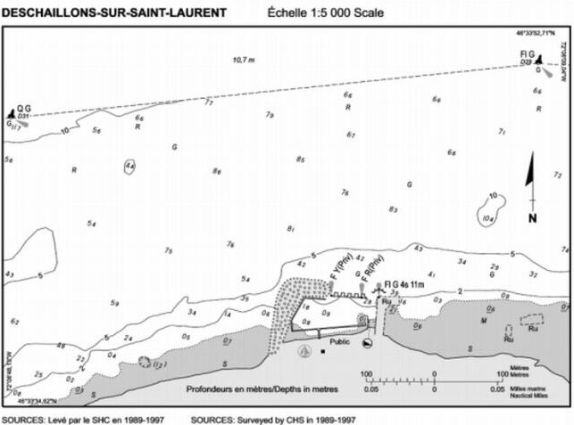
Replace the DESCHAILLONS-SUR-SAINT-LAURENT Diagram with the new one provided in Section IV of this Monthly Edition.
(Q2008-004.3)
Chapter 1 - Delete paragraph 90.
(Q2008-004.4)
ATL 120 - Labrador, Camp Islands to Hamilton Inlet (including Lake Melville), First Edition, 2004 -
Chapter 1 - After paragraph 176
Insert: 176.1 The eastern Public wharf at Charlottetown has an additional 59 m (194 ft) long wharf section added in an ENE direction to its outer end, making it L-shaped. A depth of 4 m (13 ft) is reported alongside the outer end of the new section 7 m (23 ft) wide. A large fish plant is located adjacent to this wharf. A stone breakwater has been constructed about 100 m (328 ft) NE of the outer end of the western Public wharf. A floating wharf is moored off the outer end of the breakwater.
(N2008-04.9)
CEN 301 - St. Lawrence River, Montréal to Kingston, First Edition, 1996 -
Chapter 1 - Delete paragraph 112
Replace by: 112 Submerged pipelines extend 0.1 mile offshore, immediately downstream and upstream of the Point-Claire public wharf.
(Q2007-051.1)
CEN 302 - Lake Ontario, First Edition, 1996 -
Chapter 4 - Paragraph 125, last line
Add: A second submerged pipeline here extends 0.7 mile offshore.
(C2008-003.1)
Small Craft Guide, Trent-Severn Waterway, Seventh Edition, 1989 -
Chapter II - After paragraph 171
Insert: 171.1 Hastings Village Marina is a municipal facility on the south shore above the lock. A concrete seawall anchors floating finger wharves with depths up to 8 feet (2.4 m). Potable water, 30 or 50 amp electric supply and sewage pump out is available at the berths. A telephone, washrooms and showers are available in the marina building and a double-width concrete launch ramp is at the west end of the marina property.
(C2008-001.01)
Chapter II - Delete paragraph 173
Replace by: 173 Overhead cables. - Overhead power lines with a clearance of 47 feet (14.3 m) cross the waterway near mile 52, SW of Hastings.
(C2008-001.02)
Chapter III - Paragraph 8, line 5
Delete: three
Replace by: two
(C2008-001.03)
Chapter IV - Paragraph 4, line 6
Delete: lights, buoys and day beacons
Replace by: a light, buoys and a day beacon
(C2008-001.04)
Chapter IV - Paragraph 5, line 2
Delete: 0.3
Replace by: 0.2
(C2008-001.05)
Chapter IV - Delete paragraph 13
Replace by: 13 A paved launch ramp is on the south shore close west of the bridge.
(C2008-002.01)
Chapter IV - Delete paragraphs 27 to 30
Replace by: 27 A launch ramp is on the west shore 0.1 mile north of the bridges.
28 Caution. - Submarine cables. - Submerged pipeline. - Four submarine power cables and one submarine gas pipeline cross the river in the 1 mile stretch above the bridges. Boaters are cautioned not to anchor in this vicinity.
29 The gravel launch ramp on the east shore near mile 88.4 is suitable only for small boats.
(C2008-002.02)
SECTION 5 – Edition 03/2008
LIST OF LIGHTS, BUOYS AND FOG SIGNALS CORRECTIONS
|
NEWFOUNDLAND | ||||||||||
|
51.69 |
Southeast Bight Point |
47 23 43 54 35 15 |
Q |
R |
1s |
25.0 |
4 |
Square skeleton tower, red and white rectangular daymark. 3.7 |
Year round. Chart:4622 Edn 03/08(N07-060) | |
|
ATLANTIC | ||||||||||
|
417.5 H3718 |
Cherry Cove |
On point of land between Little Harbour and Back Cove. 44 09 29.8 64 28 53.3 |
F |
G |
..... |
6.4 |
7 |
Skeleton mast. |
Operates at night only. Year round. Horn - Blast 3 s; sil. 27 s. Horn points 055º46'. Seasonal. Chart:4211 Edn 03/08 (F08-008) |
|
|
505.1 |
Big Island light buoy HR2 |
44 28 41.3 63 35 22.1 |
Q |
R |
1s |
..... |
..... |
Red, marked "HR2". |
Year round. Chart:4237 Edn 03/08 (F07-140) |
|
|
505.2 |
Big Island light buoy HR4 |
44 28 47.8 63 35 13.4 |
Fl |
R |
4s |
..... |
..... |
Red, marked "HR4". |
Year round. Chart:4237 Edn 03/08 (F07-141) |
|
|
505.3 |
Big Island light buoy HR5 |
44 28 51.2 63 35 10.7 |
Fl |
G |
4s |
..... |
..... |
Green, marked "HR5". |
Year round. Chart:4237 Edn 03/08 (F07-142) |
|
|
1032.5 |
Miminegash light and bell buoy DP2 |
Delete from list. Chart:4906 Edn 03/08 (G07-057) |
||||||||
|
1032.05 |
Miminegash light buoy DP |
NE. of reef. 46 54 03 64 14 20 |
W |
Mo(A) |
6s |
..... |
..... |
Red and white vertical stripes, marked "DP". |
Seasonal. Chart:4906 Edn 03/08 (G07-058) |
|
|
1043.1 | St. Peters Harbour Fairway light buoy JD |
46 27 09.2 62 44 21.6 |
Mo(A) |
W |
6s |
..... | ..... |
Red and white vertical stripes, marked "JD". |
Seasonal. Chart:4023 Edn 03/08 (G07-073) |
|
|
1046.8 |
Savage Harbour light and bell buoy JE2 |
Delete from list. Chart:4425 Edn 03/08 (G07-063) |
||||||||
|
1046.81 |
Savage Harbour Fairway light buoy JE |
Off harbour. 46 26 46.2 62 49 29.6 |
Mo(A) |
W |
6s |
..... |
..... |
Red and white vertical stripes, marked "JE". |
Seasonal. Chart:4425 Edn 03/08 (G07-064) |
|
|
1047.5 |
North Tracadie light and bell buoy JH1 |
Delete from list. Chart:4425 Edn 03/08 (G07-053) |
||||||||
|
1047.51 |
North Tracadie Fairway light buoy JH |
N. of harbour entrance. 46 26 03.2 63 02 01.6 |
Mo(A) |
W |
6s |
..... |
..... |
Red and white vertical stripes, marked "JH". |
Seasonal. Chart:4425 Edn 03/08 (G07-054) |
|
|
1050 |
Covehead Approach light and bell buoy JJ1 |
Delete from list. Chart:4425 Edn 03/08 (G07-055) |
||||||||
|
1050.05 |
Covehead Fairway light buoy JJ |
N. of Cape Stanhope. 46 26 54.2 63 08 18.7 |
Mo(A) |
W |
6s |
..... |
..... |
Red and white vertical stripes, marked "JJ". |
Seasonal. Chart:4425 Edn 03/08 (G07-056) |
|
|
1060.01 |
New London |
46 30 37.4 63 29 13.9 |
Iso |
W |
4s |
13.2 |
7.7 |
White square tower, red upper portion. 13.3 |
Operates at night only. Seasonal. Chart:4467 Edn 03/08 (G07-171) |
|
|
1075.2 |
Cascumpeque light buoy JV4 |
46 48 12.4 64 00 47 |
Fl |
R |
4s |
..... |
..... |
Red spar, marked "JV4". |
Seasonal. Chart:4492 Edn 03/08 (G07-137) |
|
|
1075.3 |
Cascumpeque light buoy JV5 |
46 48 07.6 64 00 51.6 |
Fl |
G |
4s |
..... |
..... |
Green, marked "JV5". |
Seasonal. Chart:4492 Edn 03/08 (G07-133) |
|
|
1075.32 |
Cascumpeque light buoy JV8 |
46 48 15.7 64 01 20.7 |
Fl |
R |
4s |
..... |
..... |
Red spar, marked "JV8". |
Seasonal. Chart:4492 Edn 03/08 (G07-134) |
|
|
1075.33 |
Cascumpeque light buoy JV6 |
46 48 13.2 64 01 05.7 |
Q |
R |
1s |
..... |
..... |
Red spar, marked "JV6". |
Seasonal. Chart:4492 Edn 03/08 (G07-138) |
|
|
1075.34 |
Cascumpeque light buoy JV7 |
46 48 07.8 64 01 08.2 |
Q |
G |
1s |
..... |
..... |
Green spar, marked "JV7". |
Seasonal. Chart:4492 Edn 03/08 (G07-139) |
|
|
1075.4 |
Cascumpeque light buoy JV9 |
46 48 08.5 64 01 37.6 |
Fl |
G |
4s |
..... |
..... |
Green spar, marked "JV9". |
Seasonal. Chart:4492 Edn 03/08 (G07-135) |
|
|
1075.5 |
Alberton Harbour light buoy JV10 |
46 48 12.9 64 01 55.4 |
Q |
R |
1s |
..... |
..... |
Red spar, marked "JV10". |
Seasonal. Chart:4492 Edn 03/08 (G07-140) |
|
|
1075.6 |
Alberton Harbour light buoy JV15 |
46 48 00.6 64 02 31.8 |
Fl |
G |
4s |
..... |
..... |
Green spar, marked "JV15". |
Seasonal. Chart:4492 Edn 03/08 (G07-165, 177) |
|
|
1075.8 |
Alberton Harbour light buoy JV14 |
Delete from list. Chart:4492 Edn 03/08 (G08-007) |
||||||||
|
2023 H2362 2024 H2362.1 |
Pointe des Grondines range |
| | | | | | | | |
On point. 46 34 43.5 72 04 11.8 066°37' 2441 m from front. |
F F |
G G |
..... ..... |
14.6 38.6 |
15 15 |
Square skeleton tower, orange daymark, black vertical stripe. 8.8 Skeleton tower, orange slatwork daymark, black vertical stripe. 31.4 |
Visible in line of range. Year round. Visible in line of range. Year round. Chart:1314 Edn 03/08 (Q07-149, 150) |
|
2025 H2364 2026 H2364.1 |
Pointe des Grondines Upper range |
| | | | | | | | |
On river bank. 46 35 06.4 72 05 52 047°18' 1997.5m from front. |
F F |
G G |
..... ..... |
9.2 29.9 |
15 19 |
White cylindrical tower, orange daymark, black vertical stripe. 8.7 Skeleton tower, orange slatwork daymark, black vertical stripe. 14.3 |
Visible in line of range. Year round. Visible in line of range. Year round. Chart:1314 Edn 03/08 (Q07-151) |
|
2286.7 H2453 |
Île Saint-Ours South Racon - - (M) X & S Band |
45 54 20.5 73 13 31.5 |
Iso |
Y |
2s |
15.1 |
5 |
Square skeleton tower. 6.5 |
Operates at night only. Year round. Chart:1311 Edn. 03/08 | |
|
INLAND WATERS | ||||||||||
|
88 |
Lighted spar D6 |
45 13 46.3 74 12 33.7 |
Fl |
R |
4s |
..... |
..... |
Red spar, marked "D6". |
Seasonal. (In place Year round.) Chart:1432 Edn 03/08(B08-029) |
|
|
89 |
Lighted spar D5 |
45 13 41.9 74 12 32.7 |
Fl |
G |
4s |
..... |
..... |
Green spar, marked "D5". |
Seasonal. (In place Year round.) Chart:1432 Edn 03/08(B08-030) |
|
|
89.5 |
St-Zotique Anchorage Area lighted spar DE |
45 13 29.2 74 13 31.6 |
Fl |
Y |
4s |
..... |
..... |
Yellow spar, marked "DE". |
Seasonal. (In place Year round.) Chart:1432 Edn 03/08(B08-033) |
|
|
90 |
Lighted spar D8 |
45 13 41.5 74 13 33.3 |
Fl |
R |
4s |
..... |
..... |
Red spar, marked "D8". |
Seasonal. (In place Year round.) Chart:1432 Edn 03/08(B08-031) |
|
|
90.4 |
St-Zotique Anchorage lighted spar DC |
45 14 10.2 74 13 36.6 |
Fl |
Y |
4s |
..... |
..... |
Yellow spar, marked "DC". |
Seasonal. (In place Year round.) Chart:1432 Edn 03/08(B08-034) |
|
|
91 |
Lighted spar D10 |
45 13 39.2 74 15 14.6 |
Q |
R |
1s |
..... |
..... |
Red spar marked "D10". |
Seasonal. (In place Year round.) Chart:1432 Edn 03/08(B08-032) |
|
|
92 |
Lighted spar D9 |
45 13 27.2 74 14 50.6 |
Q |
G |
1s |
..... |
..... |
Green spar, marked "D9". |
Seasonal. (In place Year round.) Chart:1432 Edn 03/08(B08-035) |
|
|
93 |
Lighted spar D12 |
45 13 09.2 74 16 14.7 |
Fl |
R |
4s |
..... |
..... |
Red spar, marked "D12". |
Seasonal. (In place Year round.) Chart:1432 Edn 03/08(B08-036) |
|
|
95 |
Lighted spar D13 |
45 12 30 74 17 06 |
Fl |
G |
4s |
..... |
..... |
Green spar, marked "D13". |
Seasonal. (In place Year round.) Chart:1432 Edn 03/08(B08-037) |
|
|
97 |
Lighted spar D18 |
45 12 31.4 74 17 52.9 |
Q |
R |
1s |
..... |
..... |
Red spar, marked "D18". |
Seasonal. (In place Year round.) Chart:1432 Edn 03/08(B08-038) |
|
|
98 |
Lighted spar D17 |
45 12 14.3 74 17 52 |
Q |
G |
1s |
..... |
..... |
Green spar, marked "D17". |
Seasonal. (In place Year round.) Chart:1432 Edn 03/08(B08-039) |
|
|
101 |
Lighted spar D24 |
45 10 54.1 74 19 09.8 |
Q |
R |
1s |
..... |
..... |
Red spar, marked "D24". |
Seasonal. (In place Year round.) Chart:1432 Edn 03/08(B08-040) |
|
|
102 |
Lighted spar D23 |
45 10 48 74 19 00.3 |
Q |
G |
1s |
..... |
..... |
Green spar, marked "D23". |
Seasonal. (In place Year round.) Chart:1432 Edn 03/08(B08-041) |
|
|
103 |
Lighted spar D26 |
45 10 34.5 74 19 49 |
Fl |
R |
4s |
..... |
..... |
Red spar, marked "D26". |
Seasonal. (In place Year round.) Chart:1432 Edn 03/08(B08-042) |
|
|
106 |
Lighted spar D25 |
45 10 03.1 74 20 35.3 |
Fl |
G |
4s |
..... |
..... |
Green spar, marked "D25". |
Seasonal. (In place Year round.) Chart:1432 Edn 03/08(B08-043) |
|
|
108 |
Lighted spar D28 |
45 09 18.4 74 22 20.9 |
Fl |
R |
4s |
..... |
..... |
Red spar, marked "D28". |
Seasonal. (In place Year round.) Chart:1432 Edn 03/08(B08-044) |
|
|
109 |
Lighted spar D30 |
45 08 43.6 74 23 30.4 |
Fl |
R |
4s |
..... |
..... |
Red spar, marked "D30". |
Seasonal. (In place Year round.) Chart:1432 Edn 03/08(B08-045) |
|
|
110 |
Lighted spar D31 |
45 08 17.4 74 24 01.1 |
Fl |
G |
4s |
..... |
..... |
Green spar, marked "D31". |
Seasonal. (In place Year round.) Chart:1432 Edn 03/08(B08-046) |
|
|
112.5 |
Lighted spar D34 |
45 07 48.3 74 25 20.2 |
Q |
R |
1s |
..... |
..... |
Red spar, marked "D34". |
Seasonal. (In place Year round.) Chart:1432 Edn 03/08(B08-047) |
|
|
113 |
Lighted spar D36 |
45 07 38.8 74 25 58.1 |
Fl |
R |
4s |
..... |
..... |
Red spar, marked "D36". |
Seasonal. (In place Year round.) Chart:1432 Edn 03/08(B08-048) |
|
|
114 |
Lighted spar D35 |
45 07 35.7 74 25 19.3 |
Q |
G |
1s |
..... |
..... |
Green spar, marked "D35". |
Seasonal. (In place Year round.) Chart:1432 Edn 03/08(B08-049) |
|
|
114.5 |
Lighted spar D37 |
45 07 34 74 25 57.7 |
Fl |
G |
4s |
..... |
..... |
Green spar, marked "D37". |
Seasonal. (In place Year round.) Chart:1432 Edn 03/08(B08-050) |
|
|
114.8 |
Lighted spar D38 |
45 07 36.9 74 26 34.7 |
Fl |
R |
4s |
..... |
..... |
Red spar, marked "D38". |
Seasonal. (In place Year round.) Chart:1432 Edn 03/08(B08-051) |
|
|
115 |
Lighted spar D39 |
45 07 32.1 74 26 38.5 |
Fl |
G |
4s |
..... |
..... |
Green spar, marked "D39". |
Seasonal. (In place Year round.) Chart:1432 Edn 03/08(B08-052) |
|
|
117 |
Lighted spar D40 |
45 07 35.6 74 27 01.2 |
Q |
R |
1s |
..... |
..... |
Red spar, marked "D40". |
Seasonal. (In place Year round.) Chart:1432 Edn 03/08(B08-053) |
|
|
117.5 |
Lighted spar D42 |
45 07 24.5 74 27 19 |
Fl |
R |
4s |
..... |
..... |
Red spar, marked "D42". |
Seasonal. (In place Year round.) Chart:1432 Edn 03/08(B08-054) |
|
|
118 |
Lighted spar D43 |
45 07 20.4 74 27 16 |
Q |
G |
1s |
..... |
..... |
Green spar, marked "D43". |
Seasonal. (In place Year round.) Chart:1432 Edn 03/08(B08-055) |
|
|
118.4 |
Lighted spar D44 |
45 07 09 74 27 44 |
Fl |
R |
4s |
..... |
..... |
Red spar, marked "D44". |
Seasonal. (In place Year round.) Chart:1432 Edn 03/08(B08-056) |
|
|
118.6 |
Lighted spar D45 |
45 07 05.5 74 27 40 |
Fl |
G |
4s |
..... |
..... |
Green spar, marked "D45". |
Seasonal. (In place Year round.) Chart:1432 Edn 03/08(B08-057) |
|
|
119 |
Lighted spar D46 |
45 06 35.2 74 28 37.9 |
Fl |
R |
4s |
..... |
..... |
Red spar, marked "D46". |
Seasonal. (In place Year round.) Chart:1432 Edn 03/08(B08-058) |
|
|
120 |
Lighted spar D47 |
45 06 26 74 28 43.5 |
Fl |
G |
4s |
..... |
..... |
Green spar, marked "D47". |
Seasonal. (In place Year round.) Chart:1432 Edn 03/08(B08-059) |
|
|
121 |
Lighted spar D48 |
45 06 21.2 74 29 00.7 |
Q |
R |
1s |
..... |
..... |
Red spar, marked "D48". |
Seasonal. (In place Year round.) Chart:1432 Edn 03/08(B08-060) |
|
|
122 |
Lighted spar D49 |
45 06 08.3 74 29 03.1 |
Q |
G |
1s |
..... |
..... |
Green spar, marked "D49". |
Seasonal. (In place Year round.) Chart:1432 Edn 03/08(B08-061) |
|
|
125 |
Lighted spar D52 |
45 05 27.1 74 29 40.4 |
Fl |
R |
4s |
..... |
..... |
Red spar, marked "D52". |
Seasonal. (In place Year round.) Chart:1432 Edn 03/08(B08-062) |
|
|
128 |
Lighted spar D53 |
45 05 14.1 74 29 42.8 |
Q |
G |
1s |
..... |
..... |
Green spar, marked "D53". |
Seasonal. (In place Year round.) Chart:1432 Edn 03/08(B08-063) |
|
|
129 |
Lighted spar D54 |
45 05 08.7 74 29 59.6 |
Q |
R |
1s |
..... |
..... |
Red spar, marked "D54". |
Seasonal. (In place Year round.) Chart:1432 Edn 03/08(B08-064) |
|
|
132 |
Lighted spar D55 |
45 04 43.5 74 30 27.1 |
Fl |
G |
4s |
..... |
..... |
Green spar, marked "D55". |
Seasonal. (In place Year round.) Chart:1432 Edn 03/08(B08-065) |
|
|
133 |
Lighted spar D56 |
45 04 47.2 74 30 30.8 |
Fl |
R |
4s |
..... |
..... |
Red spar, marked "D56". |
Seasonal. (In place Year round.) Chart:1432 Edn 03/08(B08-066) |
|
|
133.5 |
Lighted spar D58 |
45 04 13.9 74 31 19.2 |
Fl |
R |
4s |
..... |
..... |
Red spar, marked "D58". |
Seasonal. (In place Year round.) Chart:1432 Edn 03/08(B08-067) |
|
|
134 |
Lighted spar D57 |
45 04 09.5 74 31 16.5 |
Fl |
G |
4s |
..... |
..... |
Green spar, marked "D57". |
Seasonal. (In place Year round.) Chart:1432 Edn 03/08(B08-068) |
|
|
134.5 |
Lighted spar D60 |
E. of Hamilton Island. 45 03 55.1 74 31 46.5 |
Fl |
R |
4s |
..... |
..... |
Red spar, marked "D60". |
Seasonal. (In place Year round.) Chart:1432 Edn 03/08(B08-069) |
|
|
135 |
Lighted spar D59 |
45 03 52.2 74 31 41.7 |
Fl |
G |
4s |
..... |
..... |
Green spar, marked "D59". |
Seasonal. (In place Year round.) Chart:1432 Edn 03/08(B08-070) |
|
|
138 |
Lighted spar D62 |
45 03 44.7 74 32 01.6 |
Fl |
R |
4s |
..... |
..... |
Red spar, marked "D62". |
Seasonal. (In place Year round.) Chart:1432 Edn 03/08(B08-071) |
|
|
139 |
Lighted spar D63 |
45 03 31.8 74 32 11.3 |
Q |
G |
1s |
..... |
..... |
Green spar, marked "D63". |
Seasonal. (In place Year round.) Chart:1432 Edn 03/08(B08-072) |
|
|
1445 |
Tug Point |
On SW. extremity of point, Cheery Island. 48 45 48.3 93 19 05.6 |
Fl |
W |
4s |
7.0 |
5 |
Mast, red and white rectangular daymark. |
Visible from 314° to 345°. Seasonal. Chart:6107 Edn 03/08 |
|
|
1446 |
Crowe Island |
On extreme westerly point of island. 48 43 59.5 93 18 16.8 |
Fl |
W |
4s |
8.2 |
..... |
White cylindrical mast, red and white rectangular daymark, red triangle in centre. |
Visible from 330° through N. and E. to 170°. Seasonal. Chart:6108 Edn 03/08 |
|
|
1448 |
Woodchuck Island light buoy A28 |
E. of island. 48 49 01.2 93 19 04.8 |
Fl |
R |
4s |
..... |
..... |
Red spar, marked "A28". |
Seasonal. Chart:6107 Edn 03/08(D07-055) |
|
|
1449 |
Gull Island |
E. of Little Woodchuck Island. 48 49 43.9 93 19 28.1 |
Fl |
W |
4s |
7.6 |
..... |
Cylindrical mast, red and white rectangular daymark, green square in centre. |
Seasonal. Chart:6107 Edn 03/08 |
|
|
1449.5 |
Steamboat Shoal light buoy AT7 |
48 54 11.8 93 20 18.8 |
Fl |
G |
4s |
..... |
..... |
Green spar, marked "AT7". |
Seasonal. Chart:6107 Edn 03/08(D07-056) |
|
|
1450 |
Capstan Reef |
On reef, E. of Sand Point. 48 38 05.5 93 02 58.2 |
Fl |
W |
4s |
5.2 |
5 |
White square tower. |
Seasonal. Chart:6109 Edn 03/08 |
|
|
1451 |
Bear Passage |
On SE. point, S. entrance to Bear Passage. 48 41 22.9 92 59 55.8 |
Fl |
W |
4s |
8.5 |
..... |
Cylindrical mast, red and white rectangular daymark, red triangle in centre. 6.0 |
Visible from 014° to 032°. Seasonal. Chart:6109 Edn 03/08 |
|
|
1452 |
Redgut Bay |
At entrance to bay. 48 43 33 93 00 03 |
Fl |
W |
4s |
6.4 |
..... |
Cylindrical mast. |
Seasonal. Chart:6110 Edn 03/08 |
|
|
1453 |
Kettle Point |
Entrance to Seine Bay. 48 39 56.7 92 49 14.2 |
Fl |
W |
4s |
9.1 |
5 |
Cylindrical mast. |
Visible from 076° through E. and S. to 233°. Seasonal. Chart:6111 Edn 03/08 |
|
|
1455 |
Pine Point |
On point. 48 38 58.1 93 00 14.6 |
Fl |
W |
4s |
7.9 |
..... |
Cylindrical mast, red and white rectangular daymark, green square in centre. |
Visible from 310° through N. and E. to 072°. Seasonal. Chart:6109 Edn 03/08 |
|
|
1456 |
Swell Bay |
NW. of Morton Island. 48 40 20 93 01 10 |
Fl |
W |
4s |
9.1 |
..... |
Cylindrical mast, red and white rectangular daymark. |
Visible from 360° through E. and S. to 270°. Seasonal. Chart:6109 Edn 03/08 |
|
|
1459 |
Gull Rocks |
On southerly rock. 48 33 50 92 46 35.4 |
Fl |
W |
4s |
8.8 |
..... |
Cylindrical mast, red and white rectangular daymark, green square in centre. |
Seasonal. Chart:6112 Edn 03/08 |
|
|
1460 |
Oakpoint Island |
N. point of island. 48 31 42.2 92 36 13.7 |
Fl |
W |
4s |
9.1 |
5 |
Cylindrical mast, red and white rectangular daymark, red triangle in centre. |
Visible from 090° through S. to 270°. Seasonal. Chart:6112 Edn 03/08 |
|
|
1461 |
Lichen Island |
W. end of small island. 48 40 09.8 93 11 44.5 |
Fl |
W |
4s |
7.6 |
..... |
Cylindrical mast, red and white rectangular daymark. |
Visible from 340° through N., E. and S. to 210°. Seasonal. Chart:6108 Edn 03/08 |
|
|
1461.5 |
Gash Point Reef |
On island entrance to bay. 48 40 06 93 17 24 |
Fl |
W |
4s |
5.5 |
..... |
Cylindrical mast, red and white rectangular daymark. |
Seasonal. Chart:6108 Edn 03/08(D08-007) |
|
|
1462 |
Squall Point |
E. of point. 48 39 30 93 18 32 |
Fl |
W |
4s |
5.5 |
..... |
Cylindrical mast, red and white rectangular daymark, red triangle in centre. |
Seasonal. Chart:6108 Edn 03/08 |
|
|
1463 |
Frog Creek light buoy AD10 |
At mouth of Frog Creek, Stanjikoming Bay. 48 39 33.8 93 23 17.2 |
Fl |
R |
4s |
..... |
..... |
Red spar, marked "AD10". |
Seasonal. Chart:6108 Edn 03/08(D08-001) |
|
|
1465 |
Noden Causeway East |
E. side of main span. 48 39 08.5 93 18 47.6 |
Fl |
R |
4s |
8.0 |
..... |
Cylindrical mast. |
Visible from 140° to 180°. Seasonal. Chart:6108 Edn 03/08 |
|
|
1466 |
Noden Causeway West |
W. side of main span. 48 39 08.5 93 18 49.1 |
Fl |
W |
4s |
8.0 |
..... |
Cylindrical mast. |
Visible from 000° to 040°. Seasonal. Chart:6108 Edn 03/08 |
|
|
1467 |
Five Mile Dock |
At outer end of wharf. 48 39 00.8 93 19 10.9 |
Fl |
W |
4s |
7.0 |
5 |
Cylindrical mast. |
Seasonal. Chart:6108 Edn 03/08(D08-008) |
|
|
1468 |
Fort Frances Ranier Bridge |
On shore, W. of Ranier Bridge. 48 36 50.5 93 22 01.9 |
Fl |
W |
4s |
8.5 |
..... |
Cylindrical mast, red and white rectangular daymark. |
Seasonal. Chart:6108 Edn 03/08(D08-009) | |

