
Archived information
The Standard on Web Usability replaces this content. This content is archived because Common Look and Feel 2.0 Standards have been rescinded.
Archived information is provided for reference, research or recordkeeping purposes. It is not subject to the Government of Canada Web Standards and has not been altered or updated since it was archived.
Notices to Mariners
September 24, 2021

Safety First, Service Always
Monthly Eastern Edition
CONTENTS
| Section 1 | General and Safety Information |
| Section 1A | Temporary and Preliminary Notices |
| Section 2 | Chart Corrections |
| Section 3 | Radio Aids to Marine Navigation Corrections |
| Section 4 | Sailing Directions and Small Craft Guide Corrections |
| Section 5 | List of Lights, Buoys and Fog Signals Corrections |
Notices to Mariners – Monthly Eastern Edition
Edition No. 09/2021
Aussi disponible en français :
Avis aux navigateurs – Édition mensuelle de l’Est
Édition n° 09/2021
Published under the Authority of:
Canadian Coast Guard Programs
Aids to Navigation and Waterways
Fisheries and Oceans Canada
Montreal, QC H2Y 2E7
For more information, contact Notmar.XNCR@dfo-mpo.gc.ca.
© Her Majesty the Queen in Right of Canada,
as represented by the Minister of Fisheries, Oceans
and the Canadian Coast Guard, 2021.
Cat. No. Fs152-6E-PDF (Electronic PDF, English)
ISSN 1719-7708
Cat. No. Fs152-6F-PDF (Electronic PDF, French)
ISSN 1719-7716
Explanatory Notes – Notices to Mariners (NOTMAR)
Geographical positions refer directly to the graduations of the largest scale Canadian Hydrographic Service chart (unless otherwise indicated).
Bearings refer to the true compass and are measured clockwise from 000° (North) clockwise to 359°; those relating to lights are from seaward.
Visibility of lights is that in clear weather.
Depths - The units used for soundings (metres, fathoms or feet) are stated in the title of each chart.
Elevations are normally given above Higher High Water, Large Tide (unless otherwise indicated).
Distances may be calculated as follows:
1 nautical mile = 1,852 metres (6,076.1 feet)
1 statute mile = 1,609.3 metres (5,280 feet)
1 metre = 3.28 feet
Temporary and Preliminary Notices to Mariners – Section 1A of Notices to Mariners
These notices are indicated by a (T) or a (P), respectively. Please note that nautical charts are not amended by the Canadian Hydrographic Service for temporary (T) and preliminary (P) notices. It is recommended that mariners chart these corrections in pencil. For the list of charts affected by (T) & (P) notices, please refer to the current Notices to Mariners - Monthly Summary of Temporary and Preliminary Notices publication.
Suggestions and Corrections Form
This form is specifically for suggestions and corrections to Notices to Mariners publications. It is available online and also in fillable PDF format included with the monthly publication ZIP file.
To report chart discrepancies and/or corrections to the Sailing Directions booklets: Fill out the Marine Information Reporting Form and/or email chsinfo@dfo-mpo.gc.ca.
To report emergencies or navigational hazards: Contact your nearest MCTS centre
- VHF channel 16 (156.8 MHz)
- MF/HF frequency 2182 kHz/4125 kHz (where available)
- ∗16 on a cellphone (where available)
NOTMAR Website – Monthly Editions, Chart Corrections and Chart Patches
The NOTMAR website allows users to access the monthly publications,
chart corrections, and chart patches.
Users can subscribe for free to the email notification service
to receive notifications when charts of interest are updated, including their patches, as well as when a new Monthly Edition of Notices to Mariners is published.
In addition, the monthly publication and related
files to download, such as chart patches and Sailing
Directions diagrams, can be obtained all together
through the download of a single ZIP file.
Explanatory Notes – Canadian Hydrographic Service (CHS)
Chart Corrections – Section 2 of Notices to Mariners
Corrections to nautical charts will be listed in numerical order by chart number. Each chart correction listed applies only to that particular chart. Related charts, if any, will have their own specific correction listed separately.
Users should also refer to CHS Chart 1: Symbols, Abbreviations and Terms for additional information pertaining to the correction of charts.
The illustration below describes the elements that will comprise a typical Section 2 chart correction:

The last correction number is identified with the LNM/D or Last Notice to Mariners Number / Date.
Mariners are advised that only the most critical changes that directly affect safety to navigation are issued in “Section 2 – Chart Corrections.” This limitation is required to ensure that charts remain as clear and easy to read as possible. As a result, mariners may see minor discrepancies of a non-critical nature between information in official publications. For example, a small change in the nominal range or focal height of a light may not result in the production of a chart correction in Notices to Mariners, but may result in a correction in the List of Lights, Buoys and Fog Signals publication.
Note: In the case of a discrepancy between information provided on CHS charts relating to aids to navigation, and the List of Lights, Buoys and Fog Signals publication, the latter shall be deemed as containing the most up-to-date information.
Canadian Nautical Charts & Publications
A source list of Canadian nautical charts and publications is published in Notice No. 14 of the Notices to Mariners Annual Edition 2021. The source supply and the prices effective at the time of printing are listed. For current chart edition dates, please refer to the following website: www.chs-shc.gc.ca/charts-cartes/paper-papier/index-eng.asp
Explanatory Notes – Marine Communications and Traffic Services (MCTS)
Navigational Warnings / Notices to Shipping
The Canadian Coast Guard (CCG) is implementing a number of changes to the aids to navigation system in Canada.
These changes are advertised as Navigational Warnings, formerly called Notices to ShippingFootnote 1, that are broadcast by the CCG, and are then followed up with Notices to Mariners, then charts are updated by hand correction, reprints or new editions.
Mariners are advised that all relevant Navigational Warnings (NAVWARN) should be kept until superseded by Notices to Mariners or through revised charts issued by the Canadian Hydrographic Service (CHS).
NAVWARN are accessible on the applicable regional page on the CCG Navigational Warnings website at http://nis.ccg-gcc.gc.ca.
CHS is reviewing the impact of these changes with CCG and together are preparing an action plan on the issuing of chart revisions.
For further information, contact your regional NAVWARN Issuing Desk.
Atlantic Region (North)
* Port aux Basques MCTS Centre
“N” Series NAVWARN
Canadian Coast Guard
49 Stadium Rd.
P.O. Box 99
Port aux Basques, NL A0M 1C0
Telephone: 709-695-2168 or 1-800-563-9089
Facsimile: 709-695-7784
Email: NAVWARN.MCTSPortAuxBasques@innav.gc.ca
Central Region
* Prescott MCTS Centre
“Q” and “C” Series NAVWARN
Canadian Coast Guard
401 King Street West
P.O. Box 1000
Prescott, ON K0E 1T0
Telephone: 613-925-0666
Facsimile: 613-925-4519
Email: NAVWARN.MCTSPrescott@innav.gc.ca
Atlantic Region (South)
* Sydney MCTS Centre
“M” Series NAVWARN
Canadian Coast Guard
1190 Westmount Road
Sydney, NS B1R 2J6
Telephone: 902-564-7751 or 1-800-686-8676
Facsimile: 902-564-7662
Email: NAVWARN.MCTSSydney@innav.gc.ca
Arctic Region
* Iqaluit MCTS Centre
Operational from approximately mid-May until late December.
“A” and “H” Series NAVWARN
Canadian Coast Guard
P.O. Box 189
Iqaluit, NU X0A 0H0
“A” Series NAVWARN
Telephone: 867-979-5269
“H” Series NAVWARN
Telephone: 867-979-0310
Facsimile: 867-979-4264
Email: NAVWARN.MCTSIqaluit@innav.gc.ca
* Service available in English and French.
Index
Numerical Index of Canadian Charts Affected
This numerical index lists all nautical charts mentioned in this monthly edition of Notices to Mariners. Only charts appearing in Section 2 of this publication require a chart correction. The appearance of charts in all other sections, particularly those related to the correction of other nautical publications, is included here for reference.
| 1312 | 4001 | 4512 | 4831 |
| 1313 | 4003 | 4530 | 4839 |
| 1438 | 4006 | 4587 | 4843 |
| 1510 | 4010 | 4591 | 4845 |
| 1514 | 4016 | 4592 | 4850 |
| 2019 | 4047 | 4593 | 4862 |
| 2048 | 4099 | 4616 | 4885 |
| 2085 | 4118 | 4624 | 4905 |
| 2242 | 4236 | 4641 | 4906 |
| 2243 | 4266 | 4663 | 4909 |
| 2244 | 4302 | 4667 | 5032 |
| 2259 | 4379 | 4679 | 5179 |
| 2261 | 4394 | 4680 | 8007 |
| 2282 | 4426 | 4701 | 14853 (U.S.) |
| 2291 | 4448 | 4820 | |
| 2293 | 4462 | 4821 | |
| 4000 | 4463 | 4822 |
SECTION 1 - GENERAL AND SAFETY INFORMATION
Canadian Coast Guard Publication – Comments and Suggestions on Notices to Mariners (NOTMAR) Publications
In an effort to continuously improve the Notices to Mariners publications and to provide the most efficient service possible, the Notices to Mariners team invites all mariners and other interested parties to submit comments and suggestions on possible improvements to its various publications and services at the following email address: Notmar.XNCR@dfo-mpo.gc.ca.
Transport Canada – COVID-19 Measures, Updates and Guidance
(Recurrent publication of notice *401/20, originally published in the Notices to Mariners – Monthly Eastern Edition 04/2020 publication.)
Please refer to the link below for the latest updates to
transportation related measures taken by Transport Canada in
response to the evolving novel Coronavirus disease
(COVID-19):
https://www.tc.gc.ca/en/initiatives/covid-19-measures-updates-guidance-tc.html.
For travel advice and all other updates, please visit: Canada.ca/coronavirus.
Canadian Hydrographic Service – Notices to Mariners for Changes in Buoy Shape
(Recurrent publication of notice *906/20, originally published in the Notices to Mariners – Monthly Eastern Edition 09/2020 publication.)
As part of the CHS Digital Transformation and for the sake of economy, CHS will no longer systematically issue Notices to Mariners (NTM) for buoy shape changes only. These changes will, however, be applied to electronic navigation charts (ENCs) where applicable. The paper and raster versions will be updated during the New Edition process.
Gulf of St. Lawrence – Protection of the North Atlantic Right Whale
(Recurrent publication of notice *405/21, originally published in the Notices to Mariners – Monthly Eastern Edition 04/2021 publication.)
Purpose
This notice describes the speed restriction zones that
vessels must follow in the Gulf of St. Lawrence.
The Government of Canada has established these zones to
reduce the risk of vessel collisions with North Atlantic
right whales (NARW).
Context
Due to changing migration patterns of North Atlantic right whales and their increased presence in the Gulf of St. Lawrence, the Government of Canada has established seasonal speed restrictions in specific zones. These speed restrictions zones are defined as “static zones”, “dynamic shipping zones”, “seasonal management areas”, a trial “voluntary speed restriction zone’’ and a “restricted area”. See the map below for details.
Note: Navigational Warnings outlining the speed restrictions are considered to be Notices to Shipping, which vessels must follow. The Interim Order for the Protection of North Atlantic Right Whales (Eubalaena Glacialis) in the Gulf of St. Lawrence, 2021 enables the issuance of Navigational Warnings (NAVWARNs) imposing speed restrictions or navigation restrictions.
Speed restriction zones are described in monthly Notices to
Mariners (NOTMARs), which are published by the Canadian Coast
Guard (CCG). The status of these zones are broadcast through
NAVWARNs, which are published by the CCG’s Marine
Communications and Traffic Services (MCTS) Centres.
Changes to speed restriction zones and
measures
Based on consultations with industry and on scientific data,
changes to the speed restriction zones will be effective from
April 28, 2021, while the restricted area will be implemented
based on whale presence:
•For a second consecutive year, a trial voluntary
slowdown of 10.0 knots over the ground spanning from Cabot
Strait (a line running from Cape North NS to Cape Ray NL) to
the eastern edge of dynamic shipping zone E will be
implemented at the beginning and end of the North Atlantic
right whale season.
•Again this year, a restricted area located in and
near Shediac Valley. The location and size are both based on
historical data of North Atlantic right whale aggregations,
while the triggering mechanism is based on in-season
detections.
•As of this year, the 36.57 m (20-fathom) shallow water protocol will apply to all commercial fishing vessels.
Please refer to the latest NAVWARN issued by the CCG-MCTS for all speed restrictions currently in effect.
Speed Restriction Measures for 2021
These restrictions will be in effect from April 28 to November 15, 2021.
Exemption
The following exemption will apply to all measures:
•A vessel in distress or providing assistance to a person or a vessel in distress.
Static zones
In the static zones, all vessels above 13 m in length overall (LOA) must proceed at a speed of not more than 10.0 knots over the ground.
Exceptions
Air cushion vessels operated by or on behalf of the Government of Canada that are engaged in ice-clearing activities from April to June in and around Chaleur Bay are exempted when in operation.
36.57 m (20-fathom) shallow water protocol
Vessels engaged in any commercial fishing activity may proceed at a safe operational speed in waters not more than 36.57 m (20 fathom) deep.
If a notice to fish harvesters states that at least one right whale has been detected within a static zone in waters that are not more than 36.57 m deep, the 10 knots speed limit will apply to all vessels above 13 m in length overall (LOA) 15 days after the day on which the notice comes into effect.
If a new notice to fish harvesters with the same statement is published or broadcast during the last seven days of the 15-day period, the speed limit will continue to apply for a further 15 days after the day on which the new notice comes into effect.
|
Coordinates for the northern static zone:
•50° 20’ N 065° 00’ W • |
Coordinates for the southern static zone:
•48° 40’ N 065° 00’ W |
Dynamic shipping zones
There are five dynamic shipping zones (DSZ) located in the routeing systems north and south of Anticosti Island: A, B, C, D and E
Coordinates for the dynamic shipping zones:
|
Zone A •49⁰ 41’ N, 065⁰ 00’ W •49⁰ 20’ N, 065⁰ 00’ W •49⁰ 11’ N, 064⁰ 00’ W •49⁰ 22’ N, 064⁰ 00’ W |
Zone B •49⁰ 22’ N, 064⁰ 00’ W •49⁰ 11’ N, 064⁰ 00’ W •48⁰ 48’ N, 063⁰ 00’ W •49⁰ 00’ N, 063⁰ 00’ W |
Zone C •49⁰ 00’ N, 063⁰ 00’ W •48⁰ 48’ N, 063⁰ 00’ W •48⁰ 24’ N, 062⁰ 00’ W •48⁰ 35’ N, 062⁰ 00’ W |
|
Zone D •50⁰ 16’ N, 064⁰ 00’ W •50⁰ 00’ N, 064⁰ 00’ W •49⁰ 56’ N, 063⁰ 00’ W •50⁰ 16’ N, 063⁰ 00’ W |
Zone E
•48⁰ 35’ N 062⁰ 00’ W |
|
When the Government of Canada detects a North Atlantic right whale in a dynamic shipping zone:
•All vessels will be notified via a NAVWARN; and
•Vessels above 13 m in length overall (LOA) must
proceed at a speed of not more than 10.0 knots over the
ground within that zone.
Speed restrictions in the dynamic shipping zones
The detection of North Atlantic right whales in one or more dynamic shipping zone(s), will trigger a speed restriction in the concerned zone(s). The speed restriction in the dynamic shipping zone(s) will be in effect for 15 days from the date of issuance of the NAVWARN. The speed restriction may be extended for an additional 15 days from the date that a new NAVWARN comes into effect, if North Atlantic right whales continue to be detected during the last 7 days of the 15-day slowdown period.
When a NAVWARN is issued implementing a speed restriction in one or more dynamic shipping zone(s), vessels above 13 m in length (LOA) must not exceed a speed of 10.0 knots over the ground.
Within any zone that is not subject to a speed restriction, mariners may proceed at a safe operational speed. Mariners are encouraged to take into consideration the potential for their vessel striking North Atlantic right whales when considering a “safe operational speed” during navigation.
Seasonal management areas
Seasonal management area 1 (SMA-1) and seasonal management
area 2 (SMA-2) are speed restriction areas located north and
south of dynamic shipping zone E, respectively.
Within seasonal management areas, vessels above 13
m in length (LOA):
•must restrict their speed so as not to exceed 10.0 knots over the ground from April 28 to June 29, 2021; and
•are allowed to proceed at a safe operational speed from June 30 to November 15, 2021, unless a North Atlantic right whale is detected. If a whale is detected, a speed restriction of 10.0 knots over the ground will be triggered for 15 days from the date of issuance of the NAVWARN. The speed restriction may be extended for an additional 15 days from the date that a new NAVWARN comes into effect, if North Atlantic right whales continue to be detected during the last 7 days of the 15-day slowdown period.
|
Coordinates for the SMA-1:
•49° 04’ N 062° 00’ W |
Coordinates for the SMA-2:
•48° 24’ N 062° 00’ W |
Restricted area
In the summer months, an important proportion of the total
North Atlantic right whale population gathers for feeding and
surface activity near the Shediac
Valley. Since this makes the North Atlantic right whale
more susceptible to vessel collisions, a mandatory restricted
area will be implemented in and near the Shediac
Valley and will come into force once 80% of the
restricted area is closed to fishing for the season as per
the Department of Fisheries and Oceans’s right whale closure
protocol. The restricted area will be lifted once the
North Atlantic right whale detections decrease in the
restricted area or at the latest on August 31, 2021.
The size and location of the area is determined based on
historical detection data of North Atlantic right whales. All
necessary details can be found in the Interim Order.
Triggering and lifting of the restricted area will be
communicated to mariners through a NAVWARN and notice to fish
harvesters.
Vessels above 13 m in length (LOA) will be
required to:
•avoid the area unless they are part of the exceptions listed in the Interim Order;
•transit the area at a speed not exceeding 8.0 knots over the ground if they are included in the exception list.
The following exceptions will apply to the restricted area. Vessels listed can travel through the area at not more than 8.0 knots over the ground:
•A vessel being used for commercial fishing;
•A vessel being used for fishing under the authority
of a licence issued under the Aboriginal Communal Fishing
Licences Regulations;
•A vessel being used for research purposes on behalf
of the Government of Canada
•A vessel being used as part of the Department of
Fisheries and Oceans’ Marine Mammal Response Program to
assist a marine mammal or sea turtle in distress or to access
or retrieve a deceased marine mammal or sea turtle;
•A vessel authorized by the Government of Canada to
retrieve or identify the location of abandoned or lost
fishing gear;
•A vessel involved in pollution response
operations;
•A vessel avoiding immediate or unforeseen
danger;
•A vessel being used to conduct geophysical or
geotechnical surveys or related activities as part of a
project, which the Minister of Fisheries and Oceans has
reviewed, to lay electrical or communication cables;
•A vessel involved in research relating to right whales as part of a project that has received funding from the Government of Canada.
The following vessels can travel through the restricted area at a speed over 8.0 knots, but below 10.0 knots over the ground as required by the static speed restriction zone:
•A vessel being used by an employee of the Government of Canada or peace officer who is performing their duties.
The location and size of the restricted area will not be modified during the season.
Coordinates for the restricted area:
•48° 31.8’ N 063° 39.6’ W
•48° 24.72’ N 063° 17.88’ W
•47° 18.84’ N 064° 10.8’ W
•47° 27.18’ N 064° 30.72’ W
Inclement weather exception
Mariners will be notified in advance via a NAVWARN should the
speed restriction status change in any zone or area, due to
inclement weather.
Within any zone or area that is not subject to a speed
restriction due to adverse weather conditions for example,
mariners may proceed at a safe operational speed. Mariners
are however encouraged to take into consideration the
potential for their vessel striking North Atlantic right
whales when considering a “safe operational speed” during
navigation.
*Non-excepted vessels are still prohibited from transiting
through the restricted area.
Trial voluntary slowdown in Cabot Strait
To coincide with the North Atlantic right whales entering and exiting the Gulf of St. Lawrence in large numbers, a trial voluntary slowdown is being put in place for the second year in Cabot Strait from April 28 to June 29, 2021, and from September 29 to November 15, 2021.
•During these periods, vessels above 13 m in length (LOA) are requested to voluntarily reduce their speed so as to not exceed 10.0 knots over the ground.
Voluntary slowdown zone coordinates:
•48° 10.5’ N 061° 00’ W
•47° 37.2’ N 059° 18.5’ W
•47° 02’ N 060° 23.7’ W
•47° 58.1’ N 061° 03.5’ W
•48° 00’ N 061° 00’ W
Map of the Gulf of St. Lawrence
The following map shows
•the static zones, in pink;
•the dynamic shipping zones, in green;
•the seasonal management areas, in dark pink;
•the trial voluntary slowdown zone, in grey;
•the restricted area, in dark blue; and
•the 36.57 m (20 fathom) shallow water protocol line.
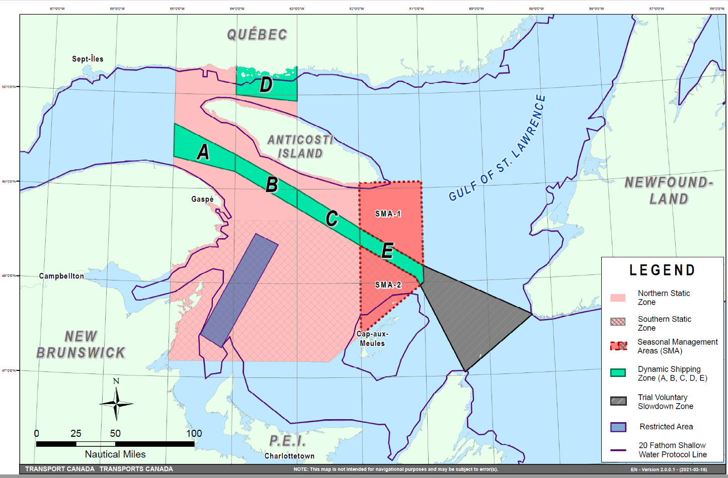
Map showing the two static zones (north and south), the five dynamic shipping zones (A, B, C, D and E), the seasonal management areas, the restricted area, the trial voluntary slowdown zone and the 36.57 m (20 fathom) shallow water protocol line.
This map is for visual representation only and is not to be used for navigation or enforcement.
NAVWARN broadcasts
The CCG-MCTS issues and publishes NAVWARNs:
•by radio broadcast; and
•online at Canada’s Maritime Information Portal and its Navigational Warnings site.
Mariners must ensure they have accurate and up-to-date
information about the protection of the North Atlantic right
whale, as in all applicable NOTMARs and NAVWARNs.
For the North Atlantic right whale speed restrictions, the
NAVWARN(s) currently in effect will be provided to vessels
subject to the Vessel Traffic Services Zone
Regulations or the Eastern Canada Vessel Traffic
Services Zone Regulations:
Outbound vessels
•at Calling-in-Point 10 (St-Laurent); or
•upon a departure downstream from the Quebec pilot station (including the Saguenay River, Chaleur Bay, Miramichi Bay, etc.)
Inbound vessels
•when a clearance to enter Canadian waters is granted
Vessels in transit
•at the last reporting point prior to entering the mandatory speed restriction zones; and/or
•at 10 nautical miles prior to entering the mandatory speed restriction zones
For those vessels not subject to the above-mentioned regulations, vessel operators are required to monitor broadcasts by the Canadian Coast Guard’s Marine Communications and Traffic Services (MCTS) network for the most up to date information. For marine radio frequencies and broadcast times, information may be found in the Radio Aids to Marine Navigation publication.
Aids to navigation
The Canadian Coast Guard is currently testing virtual
Automatic Identification System (AIS) aids to navigation (AIS
AtoN) in specific areas, NOTMAR 208(T)/2021 refers. These
aids notify mariners of a dynamic shipping zone and/or a
seasonal management area subject to a speed
restriction.
Each zone is delimited by four to six virtual AIS AtoN, which
can be displayed on a ship’s navigation equipment, such as
•Electronic Chart Display and Information System
(ECDIS);
•Electronic Chart System (ECS);
•RADAR;
•Minimum Keyboard Display (MKD); and
•Electronic Nautical Chart (ENC).
The Canadian Coast Guard broadcasts the virtual AIS AtoN only when a speed restriction is in effect in one or more testing zones.
Mariners must select the virtual AIS AtoN symbol to view a message such as “SectA1 Spd Lim 10 kt.” This message refers to a speed restriction in effect for a specific zone.
Note: This system is not the primary method of communicating this information.
Compliance and enforcement
Vessels must comply with the Interim Orders made pursuant to
the Canada Shipping Act, 2001, and any NAVWARNs
broadcast and published by the Canadian Coast Guard relating
to the Interim Orders, aimed at regulating the navigation for
the purposes of protecting the North Atlantic right
whales.
If a vessel does not comply with the Interim Orders or
instructions in the NAVWARNs related to the Interim Orders,
the vessel could face:
•administrative monetary penalties up to a maximum of CAN $250,000; and/or
•penal sanctions under the Canada Shipping Act, 2001.
If a vessel appears to have violated the speed restriction, Transport Canada Marine Safety inspectors will review all information provided through AIS and seek an explanation from the master.
No exemptions to the speed restriction will be granted in advance. However, if a deviation from the speed restrictions is necessary for safety reasons, the following information must be entered into the bridge logbook:
•Reason(s) for deviation
•Speed at which vessel is operated
•Latitude and longitude at time of deviation
•Time and duration of deviation
•Master of the vessel shall sign and date the bridge logbook entry
For any deviation, Transport Canada will review and consider reasons such as
•Navigating to ensure vessel safety;
•Weather conditions;
•Force majeure (unforeseeable circumstances); and
•Responding to emergencies.
Report a North Atlantic right whale sighting
When there is a North Atlantic right whale that is entangled, injured or dead, please report it to the nearest Canadian Coast Guard Marine Communications and Traffic Services Centre, or as follows:
Southern part of the Gulf of St. Lawrence
Marine Animal Response Society
Telephone: 1-866-567-6277
Newfoundland and Labrador
Whale Release and Strandings
Telephone: 1-888-895-3003
For the Québec Sector
Marine Mammal Emergencies
Telephone: 1-877-722-5346
If live, free-swimming whales are sighted
•Call 1-902-440-8611 (local) or 1-844-800-8568 (toll
free)
•Email: XMARWhalesightings@dfo-mpo.gc.ca
Please consult WhaleMap for the latest right whale observations: https://whalemap.ocean.dal.ca/
Saguenay–St. Lawrence Marine Park - Beluga Whale Protection: Slowdown Area at the Mouth of the Saguenay Fjord and Area Closure at Baie Sainte-Marguerite
(Recurrent publication of notice *406/21, originally published in the Notices to Mariners – Monthly Eastern Edition 04/2021 publication.)
The Saguenay–St. Lawrence Marine Park and its surrounding area are at the heart of endangered beluga whale critical summer habitat. Marine mammal protection measures have been put in place in accordance with the Marine Activities in the Saguenay–St. Lawrence Marine Park Regulations within the limits of the Marine Park.
However, important feeding, calving and rearing areas for beluga whales require greater protection to ensure the recovery of the species. The portion of the Saguenay situated between the mouth of the Fjord and Baie Sainte-Marguerite is one of the areas most used by females and their young from May to October. The mouth of the Saguenay is known as a feeding ground and Baie Sainte-Marguerite as a calving and rearing area.
In order to prevent collisions with beluga whales, a compulsory 15-knot slowdown area is in effect from May 1st to October 31st at the mouth of the Saguenay. To ensure tranquility for female belugas and their young during the critical calving period, access to Baie Sainte-Marguerite is prohibited to all vessels from June 21st to September 21st, except for special authorizations (see description below).
For safety reasons, the slowdown area measure at the
mouth of the Saguenay Fjord does not apply to cargo
ships (see the monthly edition of Notices to
Mariners from May to October for voluntary protection
measures in the St. Lawrence Estuary). An enhanced vigilance
is, however, recommended to all navigators between the mouth
of the Saguenay Fjord and Baie Sainte-Marguerite for the
protection of beluga whales.
For more information on the Saguenay–St. Lawrence Marine
Park, see notice 5C of the Notices to Mariners Annual
Edition 2021 or visit marinepark.qc.ca.
REGULATORY PROTECTION MEASURES — BELUGA WHALE
Entire Marine Park Territory:
•When beluga whales are less than half a nautical mile
(926 metres) from a motorized vessel, the vessel must
maintain a speed of between 5 and 10 knots.
•All vessels, including human-powered vessels (kayaks
and canoes), must continue to move forward and maintain their
heading.
•All vessels must maintain a minimum distance of 400 metres from beluga whales at all times.
For more information concerning the regulations, consult: marinepark.ca/protect/#regulations.
Mouth of the Saguenay Fjord (Figure 1) — Slowdown Area (area crosshatched in red):
•Maximum speed at the mouth of the Saguenay between buoys S7 and S8 and the ferry docks between Baie-Sainte-Catherine and Tadoussac is 15 knots from May 1st to October 31st.
Baie Sainte-Marguerite (Figure 2) — Area Closure (red area):
•From June 21st to September 21st, vessels must not enter the red area, which follows a line between Cap Nord-Ouest and Cap Sainte-Marguerite.
•Special authorizations are granted only for kayaks, canoes and recreational fishermen who must travel without stopping along a corridor within 10 metres of the shore or in shallow areas.
VOLUNTARY PROTECTION MEASURES
Baie Sainte-Marguerite sector (Figure 2) — Transit Area (area crosshatched in yellow):
•From June 21st to September 21st, navigation in this area is recommended at a speed of between 5 and 10 knots without stopping.
The purpose of this transit area is to favour respect of the Marine Activities in the Saguenay–St. Lawrence Marine Park Regulations, since beluga whales are often present in the Baie Sainte-Marguerite sector.
INFORMATION
All incidents, including collisions with whales, must be reported without delay by dialling 1-866-508-9888. For any other situation concerning a marine mammal that is either dead or in trouble, contact the emergency network at 1-877-722-5346, or use VHF channel 16.
Figure 1
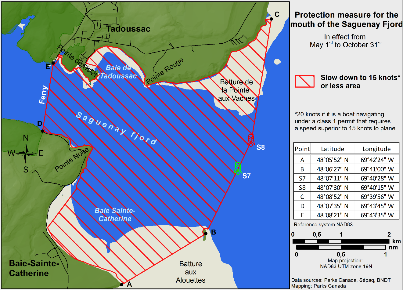
Figure 2

Saguenay-St. Lawrence Marine Park and Surrounding Waters – Whale Protection
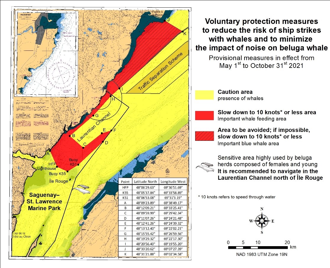
(Recurrent publication of notice *407/21, originally published in the Notices to Mariners – Monthly Eastern Edition 04/2021 publication.)
The waters in and around the Saguenay–St. Lawrence Marine Park are well known for the resident endangered beluga population and the wide diversity of whales that migrate there to feed, particularly between April and November.
REGULATORY PROTECTION MEASURES
All whale species that are found in the St. Lawrence are
protected under the Marine Mammal Regulations,
pursuant to the Fisheries Act. Within the boundaries
of the Marine Park, specific measures are set out in the
Marine Activities in the Saguenay–St. Lawrence Marine Park
Regulations, pursuant to the establishment of the
Saguenay–St. Lawrence Marine Park Act. Any collision
with a marine mammal within the Marine Park must immediately be
reported to a park warden at 1-866-508-9888. For collisions
that occur outside the Marine Park or for any situation
involving a marine mammal that is dead or in trouble, contact
the emergency network at 1-877-722-5346 or on VHF channel
16.
For more information on the Saguenay–St. Lawrence Marine
Park, see notice 5C of the Notices to Mariners Annual
Edition 2021.
VOLUNTARY PROTECTION MEASURES
Provisional measures in effect from May 1 to October 31, 2021.
See map at the end of this notice.
These measures apply to merchant vessels and cruise ships
between Pointe à Boisvert and Cap de la Tête au Chien to
prevent collisions with whales. These measures should only be
taken when they will not jeopardize navigational
safety.
Caution area (yellow area): To reduce the
risk of collisions with whales that can be present anywhere
in this area, heightened vigilance of navigators is critical.
Posting a lookout is recommended in order to increase the
chances of seeing the whales and thus taking necessary
measures to avoid them. If bypassing the whales is not
possible, slow down and wait for the animals to move away to
a distance greater than 400 metres (0.215 nautical miles)
before resuming original speed. It is more difficult to see
the animals at night therefore increased caution is
recommended.
Slow down to 10 knots or less area (red
area): To reduce the risk of collisions with whales
in this feeding area, it is recommended that vessels slow
down to a maximum speed through the water of 10 knots and
post a lookout. It is further recommended to remain in the
Laurentian Channel to the north of Île Rouge to minimize the
impact of noise in a sensitive area south of this island,
which is highly frequented by herds of beluga whales composed
of females and young.
Area to be avoided (hatched red area): To
reduce noise and the risk of collisions with whales, vessels
should avoid transiting through this area which is highly
frequented by blue whales, an endangered species. If the area
cannot be avoided, slow down to a speed through the water of
10 knots or less.
*901/21Canadian Hydrographic Service – Electronic Navigational Charts
|
S-57 ENC Number |
Chart Title |
ENC Compilation Scale |
Published |
|
New Charts |
|||
|
CA373524 (Edn 1.000) |
Kuujjuarapik |
1:37 500 |
2021-09-17 |
|
New Editions |
|||
|
CA470756 (Edn 3.000) |
Halibut Bank to/à Ballenas Channel |
1:15 000 |
2021-09-17 |
|
CA473300 (Edn 8.000) |
Lac St-Louis au/to Lac St-Francois |
1:12 500 |
2021-09-10 |
|
CA573386 (Edn 3.000) |
Baie Saint-François |
1:6 000 |
2021-09-10 |
|
CA576124 (Edn 6.000) |
Port de Grave |
1:2 500 |
2021-09-10 |
|
CA579157 (Edn 2.000) |
Carillon à/to L'Orignal |
1:10 000 |
2021-09-24 |
*902/21Transport Canada – Ship Safety Bulletin #14/2021
A new Ship Safety Bulletin has recently been posted on the Transport Canada website.
To view or download this bulletin, please click on the link below:
SSB#14/2021 – Update to the
Small Vessel Compliance Program for Fishing Vessels not more
than 15 Gross
Tonnage
RDIMS#17825880
Sign up for e-Bulletin to receive an e-mail notice each time a new Ship Safety Bulletin is published on our website.
Contact us at marinesafety-securitemaritime@tc.gc.ca or 1-855-859-3123 (Toll Free).
*904/21Adolphus Reach to/à Big Bay – Private Light Buoys Permanently Established
Reference chart: 2019
The following private yellow buoys with yellow flashing lights have been permanently established to measure turbidity :
|
Aid Name |
Position |
|
Buoy 1: |
44° 02’ 01.3”N 077° 08’ 07.1”W |
|
Buoy 2: |
44° 02’ 21.2”N 077° 07’ 33.9”W |
(NW-C-0526-21)
*905/21Rivière Ristigouche / Restigouche River – Unlit Buoys Repositioned
Reference Chart: 4426
The following unlit buoys have been repositioned:
|
Aid Name |
LL # |
Position |
|
Baie D’Escuminac buoy EV6 |
6349 |
48° 05’ 35.7”N 066° 25’ 13.5”W |
|
Anse Busteed buoy EV20 |
6359 |
48° 03’ 02.5”N 066° 32’ 58.3”W |
(G2021-118, 128)
Section 1A: Temporary and Preliminary Notices
Reminder – Comment Period for Active Preliminary Notices
This is a reminder that the comment period is still open for the following active Preliminary notices:
|
Notice # |
Reference Chart # |
Aids Affected |
Intent of Notice |
|
Atlantic Coast |
|||
|
4118 |
5220.5, 5251.6 |
Notice of Proposed Changes |
|
|
4236 |
5565.02, 5565.03, |
Notice of Proposed Changes |
|
|
4379 |
408.5 |
Notice of Proposed Changes |
|
|
4394 |
LIST |
Notice of Proposed Changes |
|
Please refer to the Notices to Mariners - Monthly Summary of Temporary and Preliminary Notices publication for details.
Newfoundland and Labrador Coast
Temporary Notices
No notices applicable for this edition.
Preliminary Notices
Atlantic Region
|
Comment
Submission |
Comments should be directed to the following: |
*906(P)/21Cape St Francis to / à Baccalieu Island and / et Heart's Content – Fog Signal to be Discontinued
Reference chart: 4850
The Canadian Coast Guard proposes to permanently discontinue the fog signal and reduce the light intensity on the following aid to navigation:
|
Aid Name |
LL # |
Position |
|
Baccalieu Island Southwest Point Light Station and Fog Signal |
473 |
48° 06’ 26.0”N 052° 48’ 39.1”W |
The light and structure will remain.
Initial publication date: Friday, September 24, 2021
Comment submission
deadline: Thursday, December 30, 2021
(N2021-169)
Atlantic Coast
No notices applicable for this edition.
Inland Waters
Temporary Notices
*907(T)/21Lac des Deux Montagnes – Missing Unlit Buoy
Reference chart: 1510
The following unlit buoy is currently missing and will not be replaced before the 2022 navigation season:
|
Aid Name |
LL # |
Position |
|
Chenal Saint-Placide buoy HJ17 |
6251.68 |
45° 31’ 20.7”N 074° 12’ 25.1”W |
(NW-Q-1526-20)
Preliminary Notices
Central Region
|
Comment
Submission |
Comments should be directed to the following:
Superintendent, Mathieu Roy |
*908(P)/21Restoule River – Aid to Navigation to be Discontinued
Reference chart: N/A
The Canadian Coast Guard proposes to permanently discontinue the following aid to navigation:
|
Aid Name |
LL # |
Position |
|
Restoule River Entrance |
1408 |
46° 02’ 01.2”N 079° 43’ 23.9”W |
Initial publication date: Friday, September 24, 2021
Comment submission
deadline: Thursday, December 30, 2021
(D2021-033)
SECTION 2 - CHART CORRECTIONS
1312 - Lac Saint-Pierre - New Edition - 10-MAY-2019 - NAD 1983
(See Chart No. 1, Qf)
(See Chart No. 1, I10)
(See Chart No. 1, I10)
1313 - Batiscan au/to Lac Saint-Pierre - New Edition - 08-MAR-2019 - NAD 1983
(See Chart No. 1, I10)
(See Chart No. 1, I10)
1438 - Grindstone Island to/à Carleton Island - New Edition - 31-AUG-2012 - World Geodetic System 1984
TO READ NOTE SUR LA VITESSE N°2 Vitesse de 9,5 NŒUDS PAR RAPPORT AU FOND dans le Canadian Middle Channel et les eaux adjacentes de l’île Ironsides, jusqu’à l’intersection avec le chenal profond au Nord de l’île Wolfe.′
1510 - Laval à/to Baie de Vaudreuil - A-B - Sheet/Feuille 2 - New Edition - 25-OCT-2019 - NAD 1983
(See Chart No. 1, A14)
Download Patch - https://www.notmar.gc.ca/chsftp/patches/1510_6410603_4_202108240948.pdf
1514 - Carillon à/to L'Orignal - Sheet/Feuille 1 - New Edition - 22-APR-2016 - NAD 1983
(See Chart No. 1, A14)
Download Patch - https://www.notmar.gc.ca/chsftp/patches/1514_6410603_2_202108200645.pdf
2085 - Toronto Harbour - New Edition - 04-MAR-2011 - NAD 1983
(See Chart No. 1, Q40)
(See Chart No. 1, K29)
2242 - Giants Tomb Island to/à Franklin Island - New Chart - 07-JAN-2005 - NAD 1983
(See Chart No. 1, K41)
(See Chart No. 1, K41)
2243 - Bateau Island to/à Byng Inlet - New Edition - 30-AUG-1985 - NAD 1927
(See Chart No. 1, I10)
(See Chart No. 1, I10)
(See Chart No. 1, I10)
(See Chart No. 1, I10)
(See Chart No. 1, I10)
(See Chart No. 1, I10)
(See Chart No. 1, I10)
(See Chart No. 1, I10)
(See Chart No. 1, K41)
(See Chart No. 1, K41)
(See Chart No. 1, K41)
(See Chart No. 1, K41)
(See Chart No. 1, K41)
(See Chart No. 1, K41)
(See Chart No. 1, K41)
(See Chart No. 1, K41)
(See Chart No. 1, K41)
2244 - Alexander Passage to/à Beaverstone Bay - New Edition - 03-NOV-2000 - NAD 1983
(See Chart No. 1, I10)
(See Chart No. 1, I10)
(See Chart No. 1, K41)
(See Chart No. 1, K41)
2261 - Bayfield to/à Douglas Point - Sheet/Feuille 1 - New Edition - 20-MAY-2016 - World Geodetic System 1984
(See Chart No. 1, P1)
2282 - Lion's Head Harbour - New Edition - 07-JUN-1996 - NAD 1983
(See Chart No. 1, P1)
to 44°59′25.9″N 081°14′53.6″W
2282 - Owen Sound to/à Cabot Head - New Edition - 07-JUN-1996 - NAD 1983
(See Chart No. 1, P1)
to 44°59′25.9″N 081°14′53.6″W
2291 - Point Clark to/à Southampton - New Edition - 31-MAR-2000 - NAD 1983
(See Chart No. 1, P1)
(See Chart No. 1, P20.2)
(See Chart No. 1, P20.1, P20.2, Pe)
2293 - Byng Inlet and Approaches / et les approches - New Edition - 30-MAR-2001 - NAD 1983
(See Chart No. 1, K41)
4000 - Gulf of Maine to/à Baffin Bay / Baie de Baffin - New Edition - 25-JUL-2003 - NAD 1983
(See Chart No. 1, L10, P2)
4001 - Gulf of Maine to Strait of Belle Isle / au Detroit de Belle Isle - New Edition - 01-DEC-1995 - NAD 1983
(See Chart No. 1, L10, P2)
(See Chart No. 1, L40.1, L44)
and 43°48′50.0″N 060°41′00.0″W
4003 - Cape Breton to / à Cape Cod - New Edition - 21-MAR-2003 - NAD 1983
(See Chart No. 1, L10, P2)
(See Chart No. 1, R1)
4006 - Newfoundland and Labrador/Terre-Neuve-et-Labrador to Bermuda / aux Bermudes - New Edition - 08-AUG-2003 - NAD 1983
(See Chart No. 1, L10, P2)
4016 - Saint-Pierre to / à St. John's - New Edition - 06-JUN-2003 - NAD 1983
(See Chart No. 1, P1)
4047 - St. Pierre Bank / Banc de Saint-Pierre to / au Whale Bank / Banc de la Baleine - New Edition - 09-OCT-1998 - NAD 1983
(See Chart No. 1, P1)
4099 - Sable Island / Île de Sable: Western Portion / Partie Ouest - New Edition - 28-DEC-2001 - NAD 1983
(See Chart No. 1, Q58)
(See Chart No. 1, L10, P2)
(See Chart No. 1, R1)
(See Chart No. 1, L3)
43°49′59.0″N 060°36′59.0″W
43°51′43.0″N 060°36′27.0″W
43°48′08.8″N 060°45′25.0″W
and 43°46′52.6″N 060°45′50.0″W
(See Chart No. 1, L21.2)
(See Chart No. 1, L21.1)
(See Chart No. 1, L21.2)
(See Chart No. 1, L21.2)
(See Chart No. 1, L21.2)
(See Chart No. 1, L21.2)
(See Chart No. 1, L40.1, L44)
and 43°50′09.6″N 060°37′18.6″W
(See Chart No. 1, L40.1)
and 43°49′24.6″N 060°39′52.4″W
(See Chart No. 1, L40.1, L44)
and 43°49′17.0″N 060°40′17.0″W
(See Chart No. 1, L40.1)
and 43°48′48.5″N 060°41′47.1″W
(See Chart No. 1, L40.1, L44)
43°48′11.0″N 060°42′17.7″W
and 43°48′44.1″N 060°41′14.3″W
(See Chart No. 1, L40.1, L44)
44°06′12.4″N 060°53′38.0″W
and 44°07′25.0″N 060°54′57.0″W
4448 - Port Hood - New Edition - 13-DEC-2002 - NAD 1983
(See Chart No. 1, Qf)
(See Chart No. 1, Qg)
(See Chart No. 1, Qg)
(See Chart No. 1, Q130.3)
4462 - St George's Bay - New Edition - 07-MAR-2003 - NAD 1983
(See Chart No. 1, Qg)
(See Chart No. 1, Qg)
4512 - Quirpon Harbour and Approaches / et les approches - New Edition - 24-JAN-2003 - NAD 1983
(See Chart No. 1, Q130.3)
to 51°35′14.4″N 055°27′12.7″W
4530 - Hamilton Sound: Eastern Portion / Partie-est - New Edition - 15-MAR-2002 - NAD 1983
(See Chart No. 1, P1)
(See Chart No. 1, P1)
4587 - Marystown Wharves / Quais - New Edition - 25-JAN-2008 - NAD 1983
(See Chart No. 1, P1)
4587 - Mortier Bay - New Edition - 25-JAN-2008 - NAD 1983
(See Chart No. 1, P1)
4591 - Pilley's Island Harbour - New Edition - 26-DEC-2003 - NAD 1983
(See Chart No. 1, Qg)
4592 - Little Bay Island to / à League Rock - New Edition - 10-OCT-2003 - NAD 1983
(See Chart No. 1, Qf)
(See Chart No. 1, Q130.3)
4593 - Sunday Cove Island to / à Thimble Tickles - New Edition - 05-DEC-2003 - NAD 1983
(See Chart No. 1, Qg)
4616 - Burin Harbours and Approches / et les approches - New Edition - 06-JUN-2003 - NAD 1983
(See Chart No. 1, P1)
4624 - Long Island to / à St. Lawrence Harbours - New Edition - 07-JAN-2000 - NAD 1983
(See Chart No. 1, P1)
4663 - Cow Head to / à Pointe Riche - New Edition - 01-AUG-2003 - NAD 1983
(See Chart No. 1, Q130.3)
(See Chart No. 1, Qf)
(See Chart No. 1, Qf)
4667 - Savage Cove to / à St Barbe Bay - New Edition - 30-MAR-2007 - NAD 1983
(See Chart No. 1, Qf)
to 51°12′43.3″N 056°46′56.4″W
4667 - St. Barbe Wharf and Approaches / Quai et Approches - New Edition - 30-MAR-2007 - NAD 1983
(See Chart No. 1, Qg)
to 51°12′23.3″N 056°46′15.1″W
4679 - Hawkes Bay, Port Saunders, Back Arm - New Edition - 29-NOV-2002 - NAD 1983
(See Chart No. 1, Q130.3)
(See Chart No. 1, Qf)
(See Chart No. 1, Qf)
(See Chart No. 1, Qg)
to 50°43′07.9″N 057°20′10.5″W
(See Chart No. 1, Qf)
(See Chart No. 1, Qf)
4680 - Hawkes Bay to / à Ste Geneviève Bay including / y compris St. John Bay - New Edition - 07-NOV-2003 - NAD 1983
(See Chart No. 1, Q130.3)
(See Chart No. 1, Qf)
(See Chart No. 1, Qf)
4701 - Ship Harbour Head to / aux Camp Islands - New Edition - 13-DEC-2002 - NAD 1983
(See Chart No. 1, Qg)
(See Chart No. 1, Q130.3)
(See Chart No. 1, Q130.3, Qg)
4820 - Cape Freels to / à Exploits Islands - New Chart - 01-JUL-2005 - NAD 1983
(See Chart No. 1, P1)
(See Chart No. 1, P1)
4821 - White Bay and / et Notre Dame Bay - New Chart - 23-APR-2004 - NAD 1983
(See Chart No. 1, Q130.3)
(See Chart No. 1, P1)
4822 - Cape St John to / à St Anthony - New Chart - 30-JUN-2006 - NAD 1983
(See Chart No. 1, P1)
4831 - Fortune Bay: Northern Portion / Partie Nord - New Chart - 26-DEC-1986 - NAD 1983
(See Chart No. 1, P1)
(See Chart No. 1, F14)
and 47°37′56.3″N 054°53′07.9″W
4839 - Continuation A - New Edition - 28-JAN-2011 - NAD 1983
(See Chart No. 1, P1)
4843 - Head of / Fond de St Mary's Bay - New Edition - 26-DEC-2003 - NAD 1983
(See Chart No.1, P1)
4843 - St Mary's Harbour and Adjacent Anchorages / et mouillages adjacents - New Edition - 26-DEC-2003 - NAD 1983
(See Chart No. 1, P1)
4850 - Old Perlican - New Chart - 11-MAY-1990 - NAD 1983
(See Chart No. 1, Qf)
to 48°05′33.5″N 053°01′05.2″W
(See Chart No. 1, Qg)
to 48°05′30.3″N 053°00′57.2″W
4885 - Port Harmon - New Edition - 08-MAR-2002 - NAD 1983
(See Chart No. 1, I22)
(See Chart No. 1, I22)
(See Chart No. 1, I22)
5032 - Pensons Arm - New Chart - 31-JAN-2003 - NAD 1983
(See Chart No. 1, Qf)
5179 - Alexis Bay - New Edition - 10-OCT-2003 - NAD 1983
(See Chart No. 1, Qg)
(See Chart No. 1, Q130.3)
(See Chart No. 1, Q130.3, Qg)
5179 - Alexis River - New Edition - 10-OCT-2003 - NAD 1983
(See Chart No. 1, Qg)
8007 - Halifax to / à Sable Island / Île de Sable, Including / y compris Emerald Bank / Banc d'Émeraude and / et Sable Island Bank / Banc de l'Île de Sable - New Edition - 30-AUG-2002 - NAD 1983
(See Chart No. 1, Q58)
(See Chart No. 1, L10, P2)
(See Chart No. 1, R1)
(See Chart No. 1, L3)
43°49′59.0″N 060°36′59.0″W
43°51′43.0″N 060°36′27.0″W
43°48′08.8″N 060°45′25.0″W
and 43°46′52.6″N 060°45′50.0″W
(See Chart No. 1, L21.1)
(See Chart No. 1, L21.1)
(See Chart No. 1, L21.1)
(See Chart No. 1, L21.1)
(See Chart No. 1, L21.1)
(See Chart No. 1, L21.1)
(See Chart No. 1, L40.1, L44)
and 43°50′09.6″N 060°37′14.0″W
(See Chart No. 1, L40.1, L44)
43°48′13.0″N 060°42′11.0″W
and 43°48′44.1″N 060°41′14.3″W
SECTION 3 - RADIO AIDS TO MARINE NAVIGATION CORRECTIONS
*909/21Radio Aids to Marine Navigation 2021 (Atlantic, St. Lawrence, Great Lakes, Lake Winnipeg, Arctic and Pacific)
Page 2-61
AMEND AS FOLLOWS FOR SECTION 2.3:
Table 2-28 - Great Lakes (includes St. Lawrence River to Montréal)
|
Name |
Class of Service |
Channel |
Remarks |
|
… |
… |
… |
… |
|
Windsor, Ont.
42°19'00"N |
- |
16 |
Operated by the Windsor Port Authority for ship traffic
control only. |
|
… |
… |
… |
… |
Page 3-1
AMEND AS FOLLOWS FOR SECTION 3.1:
There is no intention on the part of the Canadian Coast Guard
to attempt to navigate or manoeuvre ships from a shore station
and nothing in this publication overrides the authority of the
master of his their responsibility for the safe
navigation of his their ship. Information passed to
the master is intended to assist him them in the safe conduct of
his their ship.
Page 3-2
AMEND AS FOLLOWS FOR SECTION 3.3.1:
Where a ship, for any reason other than ship board radio
equipment failure is unable to obtain the required traffic
clearance or after receiving a traffic clearance, is unable to
maintain direct communication with the appropriate MCTS Centre,
the master may nevertheless proceed on his their route, but shall take all
reasonable measures to communicate with the appropriate MCTS
Centre as soon as possible and obtain the specified clearance.
Page 4-22
AMEND AS FOLLOWS FOR SECTION 4.2.2:
Master
(2) While a vessel is undergoing repairs, modifications or
conversions in dry dock or in port or is laid up, the vessel’s
master may, on his or her
their own initiative,
and shall, if directed to do so by the Minister,
a)reduce the frequency of the transmission of LRIT information to once every 24 hours; or
b)temporarily stop the transmission of LRIT information.
Pages 4-37 to 4-38
AMEND AS FOLLOWS FOR SECTION 4.2.7.9:
Table 4-8 - Sailing Plan and Departure Report Example
|
EXAMPLE |
EXPLANATION |
|
… |
Required …
Optional |
Table 4-9 - Final Arrival Report Example
|
EXAMPLE |
EXPLANATION |
|
… |
Required …
Optional |
Table 4-10 - Position Report Example
|
EXAMPLE |
EXPLANATION |
|
… |
Required …
Optional |
Table 4-11 - Deviation Report Used to Report Sailing Plan and Other Changes Example
|
EXAMPLE |
EXPLANATION |
|
… |
Required …
One or more
of the following optional items |
Page 4-78
AMEND AS FOLLOWS FOR SECTION 4.3.11:
Non-Canadian ships (except Liberian ships) may obtain a cargo
Ship Safety Radio Certificate (GMDSS) in Canada. Applications
should originate with the owners, ship agents or masters of the
ships concerned and be supported by confirmation from the
Consul or other official representative of the country in which
the ship is registered. Confirmation shall be in writing. It is
the responsibility of the owner, agent or master to contact the
Consul or official representative and arrange to submit the
necessary confirmation to the local Canadian Coast Guard
inspection office. Where time is limited, a verbal request for
an inspection may be accepted from the Consul or official
representative (a person who has a document from an
Administration giving him
them the official
power to act on their behalf), provided that the confirmation
is submitted later.
SECTION 4 - SAILING DIRECTIONS AND SMALL CRAFT GUIDE CORRECTIONS
Chapter 3 —Paragraph 192
Delete: Leading lights…with red stripes.
Replace by:The channel is buoyed within Canoe Gully, leading to the wharves.
(A2021-008.2)
Chapter 3 —Paragraph 214, after “…along the inner face.”
Delete: A light…end of the wharf
Replace by:The wharf is protected by a rock breakwater. A light (1103) is shown from a pipe swing pole, having a red and white daymark, on the western edge of the wharf. Another light (1103.5) is shown from a mast on the eastern extremity of the wharf.
(A2021-008.3)
Chapter 4 —Paragraph 263, after “… red, white and black rectangular daymark.”
Delete: Leading lights…south of Middle Ground.
Replace by:Another light (1345) is shown from a skeleton tower, having a green, white and black daymark. The light is situated on a point of land which is located along Dalhousie Harbour, between the east and west marine terminals.
(A2021-008.4)
SECTION 5 - LIST OF LIGHTS, BUOYS AND FOG SIGNALS CORRECTIONS
The amendments are highlighted and deletions are crossed out. For general and region-specific
information on the List of Lights, click on the following links:
Newfoundland and Labrador Coast,
Atlantic Coast,
Inland Waters and
Pacific Coast.
NEWFOUNDLAND AND LABRADOR COAST
| No. | Name |
Position ----- Latitude N. Longitude W. |
Light Characteristics |
Focal Height in m. above water |
Nominal Range |
Description ----- Height in meters above ground |
Remarks ----- Fog Signals |
|||
|---|---|---|---|---|---|---|---|---|---|---|
ST. MARY'S BAY (LL 7.5 – 14) |
||||||||||
| 8.21 | Graven Beach Wharf |
Delete from
list. Chart:4843 Edn 09/21 (N21-082) |
||||||||
PLACENTIA BAY (LL 14.4 – 79) |
||||||||||
|
38.1 H0397.3 |
Little Harbour East Wharf Light |
47 38 32.8 053 56 10.6 |
Fl | G | 4s | ….. | 2 |
|
Flash 1 s; eclipse
3 s. Year round. Chart:4839 Edn 09/21 (N21-107) |
|
|
38.56 H0396.5 |
Little Southern Harbour Breakwater Light |
Southern
Harbour. 47 43 07.8 053 57 46.3 |
Fl | G | 4s | ..... | 2 |
Mast. 2.6 |
Flash 1 s; eclipse
3 s. Operates 24 h. Year round. Chart:4839 Edn 09/21 (N21-120) |
|
| 41 | Swift Current Wharf |
Delete from
list. Chart:4839 Edn 09/21 (N21-109P) |
||||||||
| 63.55 | Marystown Wharf Light |
On outer end of
wharf. 47 09 56.2 055 08 51.5 |
Fl | Y | 4s | ….. | 2 | Mast. |
Flash 1 s; eclipse
3 s. Operates 24 h. Year round. Chart:4587 Edn 09/21 (N21-075, 153) |
|
|
64 H0373 |
Go By Point Light |
Beau Bois Cove. 47 08 23.3 055 05 18.8 |
Fl | G | 4s | 25.9 | 4 |
Square skeleton
tower, white and green rectangular
daymark.
|
Flash 1 s; eclipse
3 s. Year round. Chart:4587 Edn 09/21 (N21-111) |
|
|
67 H0370 |
Iron Island Light |
E. of Pardy
Island. 47 02 23.2 055 07 16.5 |
Fl | R | 4s | 36.0 | 5 |
Square
skeleton tower, red and white square daymark. 4.3 |
Flash 1 s; eclipse
3 s. Year round. Chart:4616 Edn 09/21 (N21-113) |
|
|
69 H0366 |
Shalloway Island Light |
SW. of Little
Burin. 47 00 14.0 055 10 11.6 |
Fl | R | 4s | 27.1 | 4 |
Square skeleton tower, red and white rectangular
daymark. 4.5 |
Flash 1 s;
eclipse 3
s. Year round. Chart:4616 Edn 09/21 (N21-114) |
|
| 72 | Corbin |
Delete from
list. Chart:4616 Edn 09/21 (N21-115) |
||||||||
FORTUNE BAY (LL 100 – 120.1) |
||||||||||
| 113.06 | English Harbour East Wharf Light |
On the public
wharf. 47 37 56.3 054 53 07.9 |
Fl | G | 4s | ….. | 2 | Mast. |
Flash 1 s; eclipse
3 s. Operates 24 h. Year round. Chart:4831 Edn 09/21 (N21-078) |
|
SOUTHWEST COAST (LL 121 – 172) |
||||||||||
| 170.5 | Pikes Island Breakwater light buoy QP6 |
Port aux
Basques. 47 34 31.8 059 07 56.0 |
Fl | R | 4s | ..... | ..... | Red, marked “QP6”. |
Year round. Chart:4641 Edn 09/21 (N21-098) |
|
STRAIT OF BELLE ISLE (LL 211 – 234) |
||||||||||
| 211.15 | Barbace Point North Cardinal light buoy XPB |
50 44
00.2 057 20 37.2 |
VQ | W | 0.5s | ….. | ….. | Black and yellow, marked “XPB”. |
Operates 24
h. Seasonal. Chart:4679 Edn 09/21 (N21-072) |
|
| 211.5 | Port au Choix light buoy XP2 |
50 44 17.9 057 20 04.2 |
Fl | R | 4s | ..... | ..... |
Red |
Seasonal. Chart:4679 Edn 09/21 (N21-134) |
|
| 211.6 | Querré Island Shoal light buoy XP3 |
Port au Choix. 50 43 07.9 057 20 10.5 |
Fl | G | 4s | ..... | ..... | Green spar, marked “XP3”. |
Seasonal. Chart:4679 Edn 09/21 (N21-132) |
|
| 211.7 | Ardent Rock light buoy XP4 |
Port au Choix
entrance. 50 43 17.3 057 20 01.2 |
Q | R | 1s | ..... | ..... | Red spar, marked “XP4”. |
Seasonal. Chart:4679 Edn 09/21 (N21-074P) |
|
| 216.1 | St Barbe light buoy XB2 |
At St Barbe
entrance. 51 12 43.3 056 46 56.4 |
Q | R | 1s | ..... | ..... | Red, marked “XB2”. |
Seasonal. Chart:4667 Edn 09/21 (N21-057, 138) |
|
| 216.12 | St Barbe Inner light buoy XB3 |
At St Barbe
entrance. 51 12 23.3 056 46 15.1 |
Fl | G | 4s | ..... | ..... | Green spar, marked “XB3”. |
Year round. Chart:4667 Edn 09/21 (N21-056) |
|
WHITE BAY (LL 235 – 269.3) |
||||||||||
| 237.2 | Vincent Shoal North Cardinal light buoy KQ |
Quirpon Harbour. 51 35 14.4 055 27 12.7 |
Q | W | 1s | ..... | ..... | Black and yellow spar, marked “KQ”. |
Seasonal. Chart:4512 Edn 09/21 (N21-065) |
|
| 263.5 | Wild Cove Wharf Light |
Seaward side of
wharf. 49 59 35.0 056 20 30.2 |
Fl | G | 4s | ….. | 4 | Pipe tower. |
Flash 1 s; eclipse
3 s. Operates 24 h. Seasonal. Chart:4821 Edn 09/21 (N21-063) |
|
NEWFOUNDLAND AND LABRADOR COAST (LL 269.99 – 325.23) |
||||||||||
| 270.4 | Red Point Bank East Cardinal light buoy NWW |
NE. of Red
Point, Denbigh Island. 52 31 21.7 055 44 21.7 |
Q(3) | W | 10s | ..... | ..... | Black, yellow and black, marked “NWW”. |
Seasonal. Chart:5179 Edn 09/21 (N21-066P) |
|
| 270.45 |
Mad Moll Rocks |
Alexis
Bay. 52 30 28.8 055 43 51.0 |
Fl | G | 4s | ..... | ….. | Green, marked “NA1/1”. |
Seasonal. Chart:5179 Edn 09/21 (N21-097) |
|
| 272.7 | Port Hope Simpson light buoy NA13 |
At the
entrance. 52 32 26.7 056 13 41.3 |
Fl | G | 4s | ….. | ….. | Green spar, marked “NA13”. |
Operates 24
h. Seasonal. Chart:5179 Edn 09/21 (N21-069) |
|
| 279.287 | Pinsent’s Arm Inner light buoy NMP6 |
52 41
17.0 055 53 13.7 |
Q | R | 1s | ….. | ….. | Red spar, marked “NMP6”. |
Operates 24
h. Seasonal. Chart:5032 Edn 09/21 (N21-070) |
|
| 279.9 | Barr Tickle North light buoy NMN1 |
St. Michaels
Bay. 52 46 56.6 055 54 07.0 |
Q | G | 1s | ….. | ….. | Green spar, marked “NMN1”. |
Operates 24
h. Seasonal. Chart:5032 Edn 09/21 (N21-092P) |
|
NOTRE DAME BAY (LL 326 – 346.4, 354 – 395) |
||||||||||
| 331.9 | Black Rock Sunker East Cardinal light buoy DLB |
Little Bay
Islands. 49 38 11.5 055 45 55.6 |
Q(3) | W | 10s | ….. | …. | Black, yellow and black spar, marked “DLB”. |
Seasonal. Chart:4592 Edn 09/21 (N21-053) |
|
| 341.494 | Haywards Gull Island light buoy DR1/1 |
Entrance to
Robert’s Arm. 49 29 57.9 055 46 30.1 |
Fl | G | 4s | ….. | ….. | Green spar, marked “DR1/1”. |
Operates 24
h. Seasonal. Chart:4593 Edn 09/21 (N21-064) |
|
| 372.61 | Stag Harbour Run light buoy DX7 |
49 33
37.2 054 16 29.1 |
Fl | G | 4s | ….. | ….. | Green spar, marked “DX7”. |
Operates 24
h. Seasonal. Chart:4530 Edn 09/21 (N21-093P) |
|
| 388.2 | Noggin Cove light buoy DN4 |
49 25
01.6 054 18 42.5 |
Fl | R | 4s | ..... | ..... | Red spar, marked “DN4”. |
Seasonal. Chart:4862 Edn 09/21 (N21-023) |
|
| 388.3 | Noggin Cove light buoy DN5 |
49 25
02.4 054 18 37.0 |
Fl | G | 4s | ..... | ..... | Green spar, marked “DN5”. |
Seasonal. Chart:4862 Edn 09/21 (N21-024) |
|
BONAVISTA BAY (LL 396 – 449.5) |
||||||||||
| 396.75 | Musgrave Harbour Outer Breakwater Light |
49 27 36.2 053 57 19.7 |
Fl | W | 4s | ….. | 4 |
Cylindrical mast. 2.4 |
Flash 1 s; eclipse
3 s. Seasonal. Chart:4530 Edn 09/21 (N21-049) |
|
|
399 H0594 |
Muddy Hole Point Light |
49 27 23.1 053 56 28.5 |
Fl | G | 4s | 7.9 | 4 |
Square skeleton tower, green and white rectangular
daymark. 4.3 |
Flash 1 s;
eclipse 3
s. Operates 24 h. Seasonal. Chart:4530 Edn 09/21 (N21-062) |
|
TRINITY BAY (LL 450.1 – 471.51) |
||||||||||
|
470.5 H0503.2 |
Old Perlican Inner Breakwater Light |
48 05 14.0 053 00 29.6 |
Fl | R | 3s | 4.6 | 4 |
2.6 |
Flash 0.5 s;
eclipse 2.5 s. Year round. Chart:4850 Edn 09/21 (N21-155) |
|
| 470.51 | Old Perlican Inner light buoy TP9 |
48 05 15.3 053 00 31.4 |
Fl | G | 4s | ..... | ..... | Green spar, marked “TP9”. |
Seasonal. Chart:4850 Edn 09/21 (N21-088) |
|
| 470.52 | Old Perlican Inner light buoy TP |
48 05
17.7 053 00 25.1 |
Fl | Y | 4s | ….. | ….. | Yellow spar, marked “TP”. |
Operates 24
h. Seasonal. Chart:4850 Edn 09/21 (N21-127) |
|
| 470.53 | Old Perlican Inner Harbour light buoy TP11 |
48 05 17.8 053 00 27.5 |
Fl | G | 4s | ..... | ..... | Green spar, marked “TP11”. |
Seasonal. Chart:4850 Edn 09/21 (N21-089) |
|
| 470.54 | Old Perlican Inner light buoy TP11 |
Delete from
list. Chart:4850 Edn 09/21 (N21-126) |
||||||||
| 470.71 | Old Perlican Inner light buoy TP6 |
48 05 18.9 053 00 48.2 |
Fl | R | 4s | ..... | ..... | Red spar, marked “TP6”. |
Seasonal. Chart:4850 Edn 09/21 (N21-087) |
|
| 470.72 | Old Perlican Inner light buoy TP7 |
48 05 19.8 053 00 47.9 |
Fl | G | 4s | ..... | ..... | Green spar, marked “TP7”. |
Seasonal. Chart:4850 Edn 09/21 (N21-086P) |
|
| 470.73 | Old Perlican Outer light buoy TP4 |
48 05 25.5 053 00 53.4 |
Fl | R | 4s | ..... | ..... | Red spar, marked “TP4”. |
Seasonal. Chart:4850 Edn 09/21 (N21-085) |
|
| 470.74 | Old Perlican Outer light buoy TP5 |
48 05 25.7 053 00 51.8 |
Fl | G | 4s | ..... | ..... | Green spar, marked “TP5”. |
Seasonal. Chart:4850 Edn 09/21 (N21-090) |
|
| 470.75 | Old Perlican Outer light buoy TP3 |
At entrance to
channel. 48 05 30.3 053 00 57.2 |
Fl | G | 4s | ….. | ….. | Green spar, marked “TP3”. |
Operates 24
h. Seasonal. Chart:4850 Edn 09/21 (N21-077) |
|
| 470.76 | Old Perlican Outer light buoy TP2 |
At the entrance
to channel. 48 05 33.6 053 00 05.4 |
Fl | R | 4s | ….. | ….. | Red spar, marked “TP2”. |
Operates 24
h. Seasonal. Chart:4850 Edn 09/21 (N21-076) |
|
CAPE ST. FRANCIS TO RENEWS (LL 499 – 516) |
||||||||||
| 509.5 | Aquaforte Breakwater Shoal light buoy MA2 |
Aquaforte Harbour. 47 00 18.4 052 57 40.4 |
Fl | R | 4s | ..... | ..... | Red spar, marked “MA2”. |
Year round. Chart:4845 Edn 09/21 (N21-091) |
|
ATLANTIC COAST
| No. | Name |
Position ----- Latitude N. Longitude W. |
Light Characteristics |
Focal Height in m. above water |
Nominal Range |
Description ----- Height in meters above ground |
Remarks ----- Fog Signals |
|||
|---|---|---|---|---|---|---|---|---|---|---|
BAY OF FUNDY, N.B. (LL 5 – 114, 145 – 157) |
||||||||||
|
150 H4076 |
West Quaco |
On Quaco Head. 45 19 25.3 065 32 08.8 |
Fl | W | 10s | 26.0 | 21 |
White rectangular tower with red upper
portion. 11.7 |
Flash 0.3 s; eclipse 9.7 s. Operates 24 h. Year round. Horn - Blast 3 s; sil. 27 s. Horn points 130°. Chart:4010 Edn 09/21 (F21-041) |
|
CAPE BRETON ISLAND, N.S. (LL 704.85 – 882.5) |
||||||||||
|
784 785H0764 H0764.1 |
Sydney South Arm range |
| | | | | | | | | | |
Near N. extremity of point. 162°32’ 151.1 m from front.
46 09 26.8 060 12 12.4 |
Oc
F
|
G
G
|
10s
…..
|
8.0
16.1
|
16
16
|
Triangular skeleton tower, white daymark with red vertical
stripe. Triangular skeleton tower, white daymark with red vertical
stripe.6.7
|
Flash 9 s;
eclipse 1 s.
Visible in line of range.Visible in line of range. Operates 24 h. Year round. Operates 24 h. Year round. Chart:4266 Edn 09/21 (G21-109, 110) |
| 874.31 | Inverness Inner light buoy VL1 |
Inverness
Harbour. 46 13 39.5 061 19 18.3 |
Q | G | 1s | ….. | ….. | Green spar, marked “VL1”. |
Operates 24 h. Seasonal. Chart:4463 Edn 09/21 (G21-076) |
|
| 879.5 | Portsmouth Point light buoy VK7 |
S. of point. 45 59 06.2 061 33 19.6 |
Q | G | 1s | ….. | ….. | Green spar, marked “VK7”. |
Seasonal. Chart:4448 Edn 09/21 (G21-082) |
|
| 882.3 | Smith Point South Cardinal light buoy VM |
Port
Hood. 46 00 23.2 061 33 07.6 |
Q(6)+LFl | W | 15s | ….. | ….. | Yellow and black spar, marked “VM”. |
Seasonal. Chart:4448 Edn 09/21 (G21-083) |
|
GULF OF ST. LAWRENCE (LL 883.2 – 940.3, 1169.1 – 1426, 1477.5 – 1584) |
||||||||||
| 883.2 | Aulds Cove light buoy VT2 |
45 38 58.2 061 26 02.1 |
Fl | R | 4s | ….. | ….. | Red, marked “VT2”. |
Buoy may be repositioned due to shifting channel. Seasonal. Chart:4302 Edn 09/21 (G21-072) |
|
| 1248.133 |
Shippegan |
47 42 46.0 064 39 50.1 |
Fl | G | 4s | …. | ..... | Green spar, marked “TJ7”. |
Buoy may be repositioned due to shifting channel. Operates 24 h. Seasonal. Chart:N/A Edn 09/21 (G21-185) |
|
PRINCE EDWARD ISLAND (LL 942 – 1084.7) |
||||||||||
|
1028.2 H1062.1 |
West Point Wharf |
End of wharf. 46 37 04.1 064 22 17.7 |
Fl | G | 4s | ….. | 4 |
Cylindrical mast,
green-white-black square daymark.
|
Flash 1 s; eclipse 3 s. Seasonal. Chart:4905 Edn 09/21 (G21-111) |
|
| 1032.45 | Miminegash South Cardinal light buoy DPA |
46 52 37.9 064 14 36.3 |
Q(6)+LFl | W | 15s | ….. | ….. | Yellow and black spar, marked “DPA”. |
Operates 24 h. Seasonal. Chart:4906 Edn 09/21 (G21-074) |
|
| 1032.55 | Miminegash East Cardinal light buoy DPC |
46 53 08.6 064 14 12.6 |
Q(3) | W | 10s | ….. | ….. | Black, yellow and black spar, marked “DPC”. |
Operates 24 h. Seasonal. Chart:N/A Edn 09/21 (G21-075) |
|
NORTHUMBERLAND STRAIT (LL 1085 – 1165.9) |
||||||||||
| 1144.5 | Richibucto Harbour light buoy Q28 |
46 42 31.3 064 48 38.5 |
Fl | R | 4s | ….. | ….. | Red, marked “Q28”. |
Buoy may be repositioned due to shifting channel. Seasonal. Chart:4909 Edn 09/21 (G21-142) |
|
ST. LAWRENCE RIVER (LL 1584.5 – 1772, 1823.8 – 2185.7, 2273 – 2365.95) |
||||||||||
| 2135 | Yamachiche light buoy S58 |
Courbe
Yamachiche. 46 12 48.7 072 49 07.9 |
Fl | R | 4s | ….. | ….. | Red spar, marked “S58”. |
Year
round. Chart:1312 Edn 09/21 (Q20-237) |
|
INLAND WATERS
| No. | Name |
Position ----- Latitude N. Longitude W. |
Light Characteristics |
Focal Height in m. above water |
Nominal Range |
Description ----- Height in meters above ground |
Remarks ----- Fog Signals |
|||
|---|---|---|---|---|---|---|---|---|---|---|
LAKE ONTARIO (LL 403.4 – 551) |
||||||||||
| 521 | Port Credit East Breakwater |
On outer end of E. breakwater. 43 32 54.8 079 34 28.9 |
Fl | R | 4s | 6.4 | 4 |
2.2 |
Private
aid. Seasonal. Chart:2048 Edn 09/21 (B21-021) |
|
| 523 | Port Credit East Breakwater Extension |
43 32 50.9 079 34 35.0 |
Q | R | 1s | 11.2 | 4 |
White cylindrical tower with red upper
portion. 5.0 |
Private
aid. Year round. Chart:2048 Edn 09/21 (B21-022) |
|
| 525 | Port Credit Inner Harbour |
43 32 53.6 079 34 49.5 |
Fl | R | 4s | 7.0 | 4 |
Red mast. 5.0 |
Private
aid. Seasonal. Chart:2048 Edn 09/21 (B21-023) |
|
DETROIT RIVER (LL 624 – 707.5) |
||||||||||
|
656
657
|
Hackett Reach range |
| | | | | | | | | | |
42 05 48.0 014°55' 303 m083 06 47.9 from front. |
F
F
|
R
R
|
.....
.....
|
13.7
24.8
|
14
14
|
White cylindrical tower, red triangular daymark
with black
vertical stripe. White skeleton tower, red triangular daymark
with black
vertical stripe.12.5 23.2 |
Visible in line of range. Visible in line of range.Operates 24 h. Year round. Operates 24 h. Year round. Chart:14853 (U.S.) Edn 09/21 (B21-019, 020) |
GEORGIAN BAY (LL 814 – 982) |
||||||||||
| 825 | Lion's Head Harbour |
On wharf. 44 59 25.9 081 14 53.6 |
Iso | W | 4s | 8.4 | 9 |
White
|
Seasonal (in place year round). Chart:2282 Edn 09/21 (D21-013) |
|
NORTH CHANNEL – LAKE HURON (LL 983 – 1041) |
||||||||||
| 1027 | Mills Island |
46 07 49.9 082 41 45.9 |
Fl | W | 4s | 10.4 | 5 |
5.1 |
Seasonal (in place
year round). Chart:2259 Edn 09/21 (D21-032) |
|
Report a problem on this page
- Date modified: