
Archived information
The Standard on Web Usability replaces this content. This content is archived because Common Look and Feel 2.0 Standards have been rescinded.
Archived information is provided for reference, research or recordkeeping purposes. It is not subject to the Government of Canada Web Standards and has not been altered or updated since it was archived.
NOTICES TO MARINERS
PUBLICATION
EASTERN EDITION
July 31, 2020

Safety First, Service Always
Published Monthly by the
CANADIAN COAST GUARD
www.notmar.gc.ca/subscribe/
CONTENTS
| Section 1 | General and Safety Information |
| Section 2 | Chart Corrections |
| Section 3 | Radio Aids to Marine Navigation Corrections |
| Section 4 | Sailing Directions and Small Craft Guide Corrections |
| Section 5 | List of Lights, Buoys and Fog Signals Corrections |
Canadian Coast Guard Programs
Aids to Navigation and Waterways
Fisheries and Oceans Canada
Montreal, Quebec
H2Y 2E7
© Her Majesty the Queen in Right of Canada, 2020
Fs152-6E-PDF
ISSN 1719-7708
Disponible en français :
Publication des Avis aux navigateurs
Édition de l'Est
Édition mensuelle Nº07/2020
Fisheries and Oceans Canada
Official Publication of the Canadian Coast Guard
EXPLANATORY NOTES
Geographical positions refer directly to the graduations of the largest scale Canadian Hydrographic Service chart unless otherwise indicated.
Bearings refer to the true compass and are measured clockwise from 000° (North) clockwise to 359°; those relating to lights are from seaward.
Visibility of lights is that in clear weather.
Depths - The units used for soundings (metres, fathoms or feet) are stated in the title of each chart.
Elevations are normally given above Higher High Water, Large Tide unless otherwise indicated.
Distances may be calculated as follows:
1 nautical mile = 1,852 metres (6,076.1 feet)
1 statute mile = 1,609.3 metres (5,280 feet)
1 metre = 3.28 feet
Temporary and Preliminary Notices to Mariners are indicated by a (T) or a (P) in Section 1, respectively. Please note that nautical charts are not amended by the Canadian Hydrographic Service for temporary (T) and preliminary (P) notices. It is recommended that mariners chart these corrections in pencil. For the list of charts affected by (T) & (P) notices, please refer to the index on page ii of the current Monthly Summary of (T) and (P) Notices publication.
Please note that, in addition to the temporary and preliminary changes normally advertised as (T) & (P) notices, there are a few permanent changes to aids to navigation that have been advertised as preliminary Notices to Mariners while charts are being updated for new editions.
Marine Information Report & Suggestion Sheet
Mariners are requested to notify the responsible authorities when new or suspected dangers to navigation are discovered, changes observed in aids to navigation or corrections to publications are seen
to be necessary. Such communications can be made using the Marine Information Report & Suggestion Sheet inserted on the last
page of each monthly edition of Notices to Mariners.
Canadian Hydrographic Service (CHS) - Information Published in Section 2 of Notices to Mariners
Mariners are advised that only the most critical changes that directly affect safety to navigation are issued in Section 2 – Chart Corrections. This limitation
is required to ensure that charts remain as clear and easy to read as possible. As a result, mariners may see minor discrepancies of a
non-critical nature between information in official publications. For example, a small change in the nominal range or focal height of a light
may not result in the production of a chart correction in Notices to Mariners, but may result in a correction in the List of Lights, Buoys and
Fog Signals publication.
In the case of a discrepancy between information provided on CHS charts relating to aids to navigation, and the List of Lights, Buoys and Fog Signals publication, the latter shall be deemed as containing the most up-to-date information.
Canadian Nautical Charts & Publications
A source list of Canadian nautical charts and publications is published in Notice No. 14 of the Notices to Mariners Annual Edition 2020. The source supply and the prices
effective at the time of printing are listed. For current chart edition dates, please refer to the following website:
www.chs-shc.gc.ca/charts-cartes/paper-papier/index-eng.asp
CHART CORRECTIONS - SECTION 2
Corrections to nautical charts will be listed in numerical order by chart number. Each chart correction listed applies only to that particular chart. Related charts, if any, will have their own specific correction listed separately.
Users should also refer to CHS Chart 1: Symbols, Abbreviations and Terms for additional information pertaining to the correction of charts.
The illustration below describes the elements that will comprise a typical Section 2 chart correction:

The last correction number is identified with the LNM/D or Last Notice to Mariners Number / Date.
NOTICES TO MARINERS WEBSITE – MONTHLY EDITIONS, CHART CORRECTIONS, AND CHART PATCHES
The Notices to Mariners website allows users to access the monthly publications,
chart corrections, and chart patches.
Users can subscribe for free to the email notification service
to receive notifications when charts of interest are updated, including their patches, as well as when a new monthly edition becomes available online.
In addition, the monthly publication and related files to download, such as chart patches and Sailing Directions diagrams, can be obtained all together through the download of a single ZIP file.
ADVISORY NAVIGATIONAL WARNINGS / NOTICES TO SHIPPING
The Canadian Coast Guard is implementing a number of changes to the aids to navigation system in Canada.
These changes are advertised as Navigational Warnings, formerly called Notices to ShippingFootnote 1, that are broadcast by the Canadian Coast Guard, and are then followed up with Notices to Mariners, then charts are updated by hand correction, reprints or new editions.
Mariners are advised that all relevant Navigational Warnings (NAVWARNs) should be kept until superseded by Notices to Mariners or through revised charts issued by the Canadian Hydrographic Service (CHS).
Navigational Warnings are accessible on the applicable regional page on the Canadian Coast Guard e-Navigation Maritime Information Portal at http://www.marinfo.gc.ca/e-nav.
The Canadian Hydrographic Service is reviewing the impact of these changes with the Canadian Coast Guard and together are preparing an action plan on the issuing of chart revisions.
For further information, contact your regional Navigational Warning (NAVWARN) Issuing Desk.
Atlantic Region
* Port aux Basques MCTS Centre
Canadian Coast Guard
49 Stadium Rd.
P.O. Box 99
Port aux Basques, NL A0M 1C0
Telephone: (709) 695-2168 or 1-800-563-9089
Facsimile: (709) 695-7784
Email: NAVWARN.MCTSPortAuxBasques@innav.gc.ca
Website: http://www.marinfo.gc.ca/e-nav
Central Region
* Prescott MCTS Centre
Canadian Coast Guard
401 King Street West
P.O. Box 1000
Prescott, ON K0E 1T0
“C” and “Q” Series
Telephone: (613) 925-0666
Facsimile: (613) 925-4519
Email: NAVWARN.MCTSPrescott@innav.gc.ca
Website: http://www.marinfo.gc.ca/e-nav
* Sydney MCTS Centre
Canadian Coast Guard
1190 Westmount Road
Sydney, NS B1R 2J6
Telephone: (902) 564-7751 or 1-800-686-8676
Facsimile: (902) 564-7662
Email: NAVWARN.MCTSSydney@innav.gc.ca
Website: http://www.marinfo.gc.ca/e-nav
Arctic Region
* Iqaluit MCTS Centre
Operational from approximately mid-May until late December.
Canadian Coast Guard
P.O. Box 189
Iqaluit, NU X0A 0H0
“A” Series
Telephone: (867) 979-5269
“H” Series
Telephone: (867) 979-0310
Facsimile: (867) 979-4264
Email: NAVWARN.MCTSIqaluit@innav.gc.ca
Website: http://www.marinfo.gc.ca/e-nav
* Service available in English and French.
Index
NUMERICAL INDEX OF CANADIAN CHARTS AFFECTED
This numerical index lists all nautical charts mentioned in this monthly edition of Notices to Mariners. Only charts appearing in Section 2 of this publication require a chart correction. The appearance of charts in all other sections, particularly those related to the correction of other nautical publications, is included here for reference.
| 1314 | 4236 | 4728 | 5349 |
| 1430 | 4320 | 4730 | 8007 |
| 1431 | 4384 | 4820 | 8047 |
| 1433 | 4395 | 4821 | 14822 |
| 1514 | 4404 | 4827 | 14830 |
| 2021 | 4406 | 4831 | 14832 |
| 2201 | 4445 | 4862 | 14833 |
| 2241 | 4459 | 4864 | 14842 |
| 4012 | 4467 | 4885 | 14844 |
| 4013 | 4468 | 4913 | 14846 |
| 4015 | 4491 | 4920 | 14847 |
| 4016 | 4530 | 4921 | 14882 |
| 4020 | 4592 | 5024 | 14883 |
| 4021 | 4593 | 5030 | 14884 |
| 4023 | 4624 | 5046 | 14887 |
| 4047 | 4625 | 5048 | 14962 |
| 4116 | 4626 | 5143 | 14968 |
| 4117 | 4643 | 5164 | 14976 |
| 4227 | 4654 | 5165 | |
| 4235 | 4680 | 5348 |
SECTION 1 - GENERAL AND SAFETY INFORMATION
TRANSPORT CANADA – RESTRICTED SPEED AREA - ST. CLAIR AND DETROIT RIVERS
(Recurrent publication of notice *1103/12, originally published in the Notices to Mariners Publication - Eastern Edition 11/2012.)
Since November 14, 2012, the restricted speed area currently in place as per the St. Clair and Detroit River Navigation Safety Regulations between the Detroit River light and Peche Island light is reduced in size by relocating the southern point of the restricted speed area from its current location at the Detroit River light to a new location at Bar Point light D33.
CANADIAN COAST GUARD PUBLICATION – COMMENTS AND SUGGESTIONS ON NOTICES TO MARINERS (NOTMAR) PUBLICATIONS
In an effort to continuously improve the Notices to Mariners publications and to provide the most efficient service possible, the Notices to Mariners team invites all mariners and other interested parties to submit comments and suggestions on possible improvements to its various publications and services at the following email address: Notmar.XNCR@dfo-mpo.gc.ca
CANADIAN HYDROGRAPHIC SERVICE – MODIFICATIONS TO THE 2020 CANADIAN TIDE AND CURRENT TABLES VOLUME 1 – ATLANTIC COAST AND BAY OF FUNDY
(Recurrent publication of notice *203/20, originally published in the Notices to Mariners Publication - Eastern Edition 02/2020.)
The Canadian Hydrographic Service of the Atlantic Region has identified an error in the 2020 Canadian Tide and Current Tables Volume 1 - Atlantic Coast and Bay of Fundy, Tide tables for Holyrood, Newfoundland (station #925)
Mariners must refer to the following link for updated information on Holyrood's Tide Tables:
SAGUENAY-ST. LAWRENCE MARINE PARK AND SURROUNDING WATERS – WHALE PROTECTION
(Recurrent publication of notice *404/20, originally published in the Notices to Mariners Publication - Eastern Edition 04/2020.)
The waters in and around the Saguenay–St. Lawrence Marine Park are well known for the resident endangered beluga population and the wide diversity of whales that migrate there to feed, particularly between April and November.
REGULATORY PROTECTION MEASURES
All whale species that are found in the St. Lawrence are protected under the Marine Mammal Regulations, pursuant to the Fisheries Act. Within the boundaries of the Marine Park, specific measures are set out in the Marine Activities in the Saguenay–St. Lawrence Marine Park Regulations, pursuant to the establishment of the Saguenay–St. Lawrence Marine Park Act. Any collision with a marine mammal within the Marine Park must immediately be reported to a park warden at 1-866-508-9888. For collisions that occur outside the Marine Park or for any situation involving a marine mammal that is dead or in trouble, contact the emergency network at 1-877-722-5346 or on VHF channel 16.
For more information on the Saguenay–St. Lawrence Marine Park, see notice 5C of the Notices to Mariners Annual Edition 2020.
VOLUNTARY PROTECTION MEASURES
Provisional measures in effect from May 1 to October 31, 2020. See map at the end of this notice.
These measures apply to merchant vessels and cruise ships between Pointe à Boisvert and Cap de la Tête au Chien to prevent collisions with whales. These measures should only be taken when they will not jeopardize navigational safety.
Caution area (yellow area): To reduce the risk of collisions with whales that can be present anywhere in this area, heightened vigilance of navigators is critical. Posting a lookout is recommended in order to increase the chances of seeing the whales and thus taking necessary measures to avoid them. If bypassing the whales is not possible, slow down and wait for the animals to move away to a distance greater than 400 metres (0.215 nautical miles) before resuming original speed. It is more difficult to see the animals at night therefore increased caution is recommended.
Slow down to 10 knots or less area (red area): To reduce the risk of collisions with whales in this feeding area, it is recommended that vessels slow down to a maximum speed through the water of 10 knots and post a lookout. It is further recommended to remain in the Laurentian Channel to the north of Île Rouge to minimize the impact of noise in a sensitive area south of this island, which is highly frequented by herds of beluga whales composed of females and young.
Area to be avoided (hatched red area): To reduce noise and the risk of collisions with whales, vessels should avoid transiting through this area which is highly frequented by blue whales, an endangered species. If the area cannot be avoided, slow down to a speed through the water of 10 knots or less.

TRANSPORT CANADA – COVID-19 MEASURES, UPDATES AND GUIDANCE
(Recurrent publication of notice *401/20, originally published in the Notices to Mariners Publication - Eastern Edition 04/2020.)
Please refer to the link below for the latest updates to transportation related measures taken by Transport Canada in response to the evolving novel Coronavirus disease (COVID-19):
https://www.tc.gc.ca/en/initiatives/covid-19-measures-updates-guidance-tc.html
For travel advice and all other updates, please visit: Canada.ca/coronavirus
CANADIAN HYDROGRAPHIC SERVICE – MODIFICATIONS TO THE 2020 CANADIAN TIDE AND CURRENT TABLES, VOLUME 2 – GULF OF ST. LAWRENCE
(Recurrent publication of notice *506/20, originally published in the Notices to Mariners Publication - Eastern Edition 05/2020.)
The Canadian Hydrographic Service of the Quebec Region has identified a correction in the 2020 Canadian Tide and Current Tables, Volume 2, Gulf of St. Lawrence, on page 79.
Mariners should replace a section of Table 3 with the corresponding section annexed below:
https://www.notmar.gc.ca/publications/monthly-mensuel/images/ed052020-part1-vol2-p79.pdf
SAGUENAY–ST. LAWRENCE MARINE PARK - BELUGA WHALE PROTECTION: SLOWDOWN AREA AT THE MOUTH OF THE SAGUENAY FJORD AND AREA CLOSURE AT BAIE SAINTE-MARGUERITE
(Recurrent publication of notice *605/20, originally published in the Notices to Mariners Publication - Eastern Edition 06/2020.)
The Saguenay–St. Lawrence Marine Park and its surrounding area are at the heart of endangered beluga whale critical summer habitat. Marine mammal protection measures have been put in place in accordance with the Marine Activities in the Saguenay–St. Lawrence Marine Park Regulations within the limits of the Marine Park.
However, important feeding, calving and rearing areas for beluga whales require greater protection to ensure the recovery of the species. The portion of the Saguenay situated between the mouth of the Fjord and Baie Sainte-Marguerite is one of the areas most used by females and their young from May to October. The mouth of the Saguenay is known as a feeding ground and Baie Sainte-Marguerite as a calving and rearing area.
In order to prevent collisions with beluga whales, a compulsory 15-knot slowdown area is in effect from May 1st to October 31st at the mouth of the Saguenay. To ensure tranquility for female belugas and their young during the critical calving period, access to Baie Sainte-Marguerite is prohibited to all vessels from June 21st to September 21st, except for special authorizations (see description below).
For safety reasons, the slowdown area measure at the mouth of the Saguenay Fjord does not apply to cargo ships (see the monthly edition of Notice to Mariners from May to October for voluntary protection measures in the St. Lawrence Estuary). An enhanced vigilance is, however, recommended to all navigators between the mouth of the Saguenay Fjord and Baie Sainte-Marguerite for the protection of beluga whales.
For more information on the Saguenay–St. Lawrence Marine Park, see notice 5C of the Notices to Mariners Annual Edition 2020 or visit http://parcmarin.qc.ca/home/.
REGULATORY PROTECTION MEASURES — BELUGA WHALE
Entire Marine Park Territory:
•When beluga whales are less than half a nautical mile
(926 metres) from a motorized vessel, the vessel must
maintain a speed of between 5 and 10 knots.
•All vessels, including human-powered vessels (kayaks
and canoes), must continue to move forward and maintain their
heading.
•All vessels must maintain a minimum distance of 400
metres from beluga whales at all times.
For more information concerning the regulations, consult: http://marinepark.ca/protect/#regulations.
Mouth of the Saguenay Fjord (Figure 1) — Slowdown Area (area cross-hatched in red):
•Maximum speed at the mouth of the Saguenay between
buoys S7 and S8 and the ferry docks between
Baie-Sainte-Catherine and Tadoussac is 15 knots from May
1st to October 31st.
Baie Sainte-Marguerite (Figure 2) — Area Closure (red area):
•From June 21st to September
21st, vessels must not enter the red area, which
follows a line between Cap Nord-Ouest and Cap
Sainte-Marguerite.
•Special authorizations are granted only for kayaks,
canoes and recreational fishermen who must travel without
stopping along a corridor within 10 metres of the shore or in
shallow areas.
VOLUNTARY PROTECTION MEASURES
Baie Sainte-Marguerite sector (Figure 2) — Transit Area (area cross-hatched in yellow):
•From June 21st to September 21st, navigation in this area is recommended at a speed of between 5 and 10 knots without stopping.
The purpose of this transit area is to favour respect of the Marine Activities in the Saguenay–St. Lawrence Marine Park Regulations, since beluga whales are often present in the Baie Sainte-Marguerite sector.
INFORMATION
All incidents, including collisions with whales, must be
reported without delay by dialling 1-866-508-9888. For any
other situation concerning a marine mammal that is either
dead or in trouble, contact the emergency network at
1-877-722-5346, or use VHF channel 16.
Figure 1

Figure 2

*701CANADIAN HYDROGRAPHIC SERVICE – NAUTICAL CHARTS
|
CHARTS |
MAIN TITLE |
SCALE |
PUBLISHED |
CAT# |
PRICE |
|
New Charts |
|
||||
|
5164 |
Lake Melville |
1:100 000 |
27-MAR-2020 |
1 |
20.00 |
|
5165 |
Epinette Point to/à Terrington Basin |
1:60 000 |
28-FEB-2020 |
1 |
20.00 |
|
New Editions |
|
|
|
|
|
|
2201 |
Georgian Bay / Baie Georgienne |
1:200 000 |
01-MAY-2020 |
3 |
20.00 |
|
4459 |
Summerside Harbour and Approaches / et les approches |
1:25 000 |
29-MAY-2020 |
1 |
20.00 |
|
Charts Permanently Withdrawn |
|||||
|
4728 |
Epinette Point to / à Terrington Basin |
||||
|
5143 |
Lake Melville |
||||
*702CANADIAN HYDROGRAPHIC SERVICE – ELECTRONIC NAVIGATIONAL CHARTS
|
S-57 ENC NUMBER |
CHART TITLE |
|
NEW PRODUCTS |
|
|
CA373469 |
Simpson Strait to/a Rasmussen Basin |
*703CANADIAN HYDROGRAPHIC SERVICE – RASTER DIGITAL CHARTS (BSB V3)
|
CHARTS |
MAIN TITLE |
SCALE |
PUBLISHED |
|
New Charts |
|
|
|
|
RM-5164 |
Lake Melville |
1:100 000 |
27-MAR-2020 |
|
RM-5165 |
Epinette Point to/à Terrington Basin |
1:60 000 |
28-FEB-2020 |
|
New Editions |
|
|
|
|
RM-2201 |
Georgian Bay / Baie Georgienne |
1:200 000 |
01-MAY-2020 |
|
RM-4459 |
Summerside Harbour and Approaches / et les approches |
1:25 000 |
29-MAY-2020 |
|
Charts Permanently Withdrawn |
|||
|
RM-4728 |
Epinette Point to / à Terrington Basin |
||
|
RM-5143 |
Lake Melville |
||
*704TRANSPORT CANADA – SHIP SAFETY BULLETINS #12 AND #18/2020
New and modified Ship Safety Bulletins have recently been posted on the Transport Canada website at www.tc.gc.ca/ssb-bsn/.
To view or download these bulletins, please click on the links below:
SSB#12/2020 – Measures to
Mitigate the Spread of COVID-19 on Passenger Vessels and
Ferries (Modified 2020-06-30)
RDIMS#16451043
SSB#18/2020 – Mobility of
Asymptomatic Workers in the Marine Sector During
COVID-19
RDIMS#16645826
Sign up for e-Bulletin to receive an e-mail notice each time a new Ship Safety Bulletin is published on our website.
Contact us at marinesafety-securitemaritime@tc.gc.ca or 1-855-859-3123 (Toll Free).
*705CANADIAN COAST GUARD PUBLICATION - AMENDMENTS TO THE NOTICES TO MARINERS ANNUAL EDITION 2020 - SECTION A2, NOTICE 5: GENERAL GUIDELINES FOR AQUATIC SPECIES AT RISK AND IMPORTANT MARINE MAMMAL AREAS GENERAL REGULATORY REQUIREMENTS FOR ALL OCEANS ACT MARINE PROTECTED AREAS
Page 2:
AMEND AS FOLLOWS:
Protecting the North Atlantic right whale:
New speed restriction measures in the Gulf of St. Lawrence
Due to changing migration of North Atlantic right whales and their increased presence in the Gulf of St. Lawrence, the Government of Canada has established seasonal speed restrictions of not more than 10.0 knots in specific zones for all vessels above 13 metres in length. Please refer to the Notices to Mariners monthly editions for additional details and consult WhaleMap for the latest right whale observations: https://whalemap.ocean.dal.ca/.
Transport Canada inspectors, with assistance from the Canadian Coast Guard’s Marine Communications and Traffic Services, will enforce this precautionary measure. Failure to comply will result in an administrative monetary penalty of up to $250,000 and/or penal sanctions under the Canada Shipping Act, 2001.
*706GULF OF ST. LAWRENCE – PROTECTION OF THE NORTH ATLANTIC RIGHT WHALE
Reference: Notice *504/20 is cancelled.
Due to changing migration patterns of North Atlantic right whales and their increased presence in the Gulf of St. Lawrence, the Government of Canada has established seasonal speed restrictions in specific zones. These speed restrictions are defined as “static zones”, “dynamic shipping zones”, “seasonal management areas”, a trial “voluntary speed restriction zone’’ and a “restricted area”. See the map below for details.
Note: Navigational Warnings with these speed restrictions are considered to be Notices to Shipping, which vessels must follow as per the Interim Order Protecting North Atlantic Right Whales (Eubalaena Glacialis) in the Gulf of St Lawrence and the Interim Order for the protection of North Atlantic Right Whales (Eubalaena Glacialis) in and near the Shediac Valley for the restricted area.
Speed restriction zones are described in monthly Notices to Mariners (NOTMARs), which are published by the Canadian Coast Guard (CCG). The status of these zones is broadcasted through Navigational Warnings (NAVWARNs), which are published by the CCG’s Marine Communications and Traffic Services (MCTS) Centres.
Changes to speed restriction zones
Based on consultations with industry and on scientific data, changes to the speed restriction zones will be effective from April 28th, 2020, while the restricted area will be implemented as per the Interim Order for the Protection of North Atlantic Right Whales (Eubalaena glacialis) in and near the Shediac Valley.
•Portions
of the static zones located north and south of dynamic
shipping zone E are now changed to seasonal management area 1
(north of dynamic shipping zone E) and seasonal management
area 2 (south of dynamic shipping zone E).
•A
trial voluntary speed restriction of 10.0 knots over the
ground spanning from Cabot Strait (a line running from Cape
North NS to Cape Ray NL) to the eastern edge of dynamic
shipping zone E, at the beginning and end of the
season.
•A
restricted area located in
and near the
Shediac Valley, determined
based on aggregation of North Atlantic right whales.
Please refer to the latest NAVWARN issued by the CCG-MCTS for all speed restrictions currently in effect.
Speed Restriction Measures for 2020
These restrictions will be in effect from April 28 to November 15, 2020.
Static zones
In the static zones, all vessels above 13 m in length overall (LOA) must proceed at a speed of not more than 10.0 knots over the ground.
|
Coordinates for the northern static zone: •50° 20’ N 065° 00’ W •49° 13’ N 065° 00’ W •48° 40’ N 064° 13’ W •48° 40’ N 062° 40’ W •48° 03’ N 061° 07.5’ W •47° 58.1’ N 061° 03.5’W •48° 00’ N 061° 00’ W •49° 04’ N 061° 00’ W •49° 04’ N 062° 00’ W •49° 43’ N 063° 00’ W •50° 20’ N 063° 00’ W |
Coordinates for the southern static zone: •48° 40’ N 065° 00’ W •48° 40’ N 062° 40’ W •48° 03’ N 061° 07,5’ W •47° 58.1’ N 061° 03,5’ W •47° 10’ N 062° 30’ W •47° 10’ N 065° 00’ W |
Mariners will be notified ahead via a NAVWARN should the speed restriction status change, due to inclement weather.
Within any static zone that is not subject to a speed restriction, mariners may proceed at a safe operational speed. Mariners are however encouraged to take into consideration the potential for their vessel striking North Atlantic right whales when considering a “safe operational speed” during navigation.
Dynamic shipping zones
There are five dynamic shipping zones (DSZ) located in the routeing systems north and south of Anticosti Island: A, B, C, D and E
Coordinates for the dynamic shipping zones:
|
Zone A •49° 41’ N 065° 00’ W •49° 20’ N 065° 00’ W •49° 11’ N 064° 00’ W •49° 22’ N 064° 00’ W |
Zone B •49° 22’ N 064° 00’ W •49° 11’ N 064° 00’ W •48° 48’ N 063° 00’ W •49° 00’ N 063° 00’ W |
Zone C •49° 00’ N 063° 00’ W •48° 48’ N 063° 00’ W •48° 24’ N 062° 00’ W •48° 35’ N 062° 00’ W |
|
Zone D •50° 16’ N 064° 00’ W •50° 00’ N 064° 00’ W •49° 56’ N 063° 00’ W •50° 16’ N 063° 00’ W |
Zone E •48° 35’ N 062° 00’ W •48° 24’ N 062° 00’ W •48° 03’ N 061° 07.5’ W •47° 58.1’ N 061° 03.5’ W •48° 00’ N 061° 00’ W •48° 10.5’ N 061° 00’ W |
|
If the Government of Canada does not detect North Atlantic right whales in these zones, vessels may transit through them at a safe operational speed.
When the Government of Canada detects a North Atlantic right whale in a dynamic shipping zone, vessels above 13 m in length overall (LOA):
•will
be notified through a NAVWARN; and
•must
proceed at a speed of not more than 10.0 knots over the
ground within that zone.
Speed restrictions in the dynamic shipping zones
The detection of North Atlantic right whales in one or more dynamic shipping zone(s), will trigger a speed restriction in the concerned zone(s). The speed restriction in the dynamic shipping zone(s) will be in effect for 15 days from the date of issuance of the NAVWARN. We may extend a speed restriction past the 15 days if North Atlantic right whales continue to be detected.
When a NAVWARN is issued implementing a speed restriction in one or more dynamic shipping zone(s), vessels above 13 m in length (LOA) must not exceed a speed of 10.0 knots over the ground.
Within any zone that is not subject to a speed restriction, mariners may proceed at a safe operational speed. Mariners are however encouraged to take into consideration the potential for their vessel striking North Atlantic right whales when considering a “safe operational speed” during navigation.
Seasonal management areas
Seasonal management area 1 (SMA-1) and seasonal management area 2 (SMA-2) are speed restriction areas located north and south of dynamic shipping zone E, respectively.
Within seasonal management areas, vessels above 13 m in length (LOA):
•must
restrict their speed so as not to exceed 10.0 knots over the
ground from April 28th to June 30th, 2020; and
•are
allowed to proceed at safe operational speed from July 1st to
November 15th, 2020, unless a North Atlantic right whale is
detected. If a whale is detected, a speed restriction of 10.0
knots over the ground will be triggered for 15 days from the
date of issuance of the NAVWARN. The speed restriction may be
extended past the 15 days if North Atlantic right whales
continue to be detected.
|
Coordinates for the SMA-1: •49° 04’ N 062° 00’ W •49° 04’ N 061° 00’ W •48° 10.5’ N 061° 00’ W •48° 35’ N 062° 00’ W |
Coordinates for the SMA-2:
•48° 24’ N 062° 00’ W |
Restricted area
In the summer months, an important proportion of the total North Atlantic right whale population gathers for feeding and surface activity near the Shediac Valley. Since this makes the North Atlantic right whale more susceptible to vessel collisions, a mandatory restricted area will be put in place in and near the Shediac Valley. The effective date and exact location of the area were based on the observed distribution of the whales. The Interim Order for the Protection of North Atlantic Right Whales (Eubalaena glacialis) in and near the Shediac Valley will provide the necessary details. This information will also be communicated to mariners through navigational warnings and notices to fish harvesters.
Vessels above 13 m in length (LOA) will be required to:
•avoid
the area unless they are
part of the exceptions listed in the IO;
•exempted vessels
transiting the area must do so at a speed not exceeding 8.0
knots over the ground.
The restricted area will be
determined in collaboration with the Department of Fisheries
and Oceans. Once established, The location and dimension
of the restricted area will not be modified.
Trial voluntary speed restriction in Cabot Strait
To coincide with the North Atlantic right whales entering and exiting the Gulf of St. Lawrence, we are putting in place a trial voluntary speed restriction in Cabot Strait from April 28th to June 15th, 2020, and from October 1st to November 15th, 2020.
•During
this period, vessels above 13 m in length (LOA) will be asked
to voluntarily reduce their speed so as to not exceed 10.0
knots over the ground.
•Outside
of the restriction period, vessels will be able to proceed at
safe operational speeds.
Voluntary speed restriction zone coordinates:
•48°
10.5’ N 061° 00’ W
•47°
37.2’ N 059° 18.5’ W
•47°
02’ N 060° 23.7’ W
•47°
58.1’ N 061° 03.5’ W
•48°
00’ N 061° 00’ W
Map of the Gulf of St. Lawrence
The following map shows
•the
speed restriction zone, in pink (static zones);
•the
dynamic shipping zones, in green;
•the
seasonal management areas, in dark pink; and
•the
trial voluntary speed restriction zone, in grey; and
•the
focus of the restricted area, in dark blue.

Map showing the two static zones (north and south), the five dynamic shipping zones (A, B, C, D and E), the seasonal management areas, the restricted area, the trial voluntary speed restriction zone and the 20 fathom shallow water protocol line.
This map is for visual representation only and is not to be used for navigation or enforcement.
NAVWARN broadcasts
The CCG-MCTS issues and publishes NAVWARNs:
•by
radio broadcast; and
•online
at Canada’s
Maritime Information Portal and its Navigational Warnings site.
Mariners must ensure they have accurate and up-to-date information about the protection of the North Atlantic right whale, as in all applicable NOTMARs and NAVWARNs.
For the North Atlantic right whale speed restriction, the NAVWARN that is currently in effect will be provided to vessels subject to the Vessel Traffic Services Zone Regulations or the Eastern Canada Vessel Traffic Services Zone Regulations:
Outbound vessels
•at
Calling-in-Point 10 (St-Laurent); or
•upon
a departure downstream from the Quebec pilot station
(including the Saguenay River, Chaleur Bay, Miramichi Bay,
etc.)
Inbound vessels
•when a clearance to enter Canadian waters is granted
Vessels in transit
•at
the last reporting point prior to entering the speed
restriction area; and/or
•at
10 nautical miles prior to entering the speed restriction
zone
For those vessels not subject to the above-mentioned regulations, vessel operators are required to monitor broadcasts by the Canadian Coast Guard’s Marine Communications and Traffic Services (MCTS) network for the most up to date information. For marine radio frequencies and broadcast times, information may be found in the Radio Aids to Marine Navigation publication.
Aids to navigation
The Canadian Coast Guard is currently testing virtual Automatic Identification System (AIS) aids to navigation (AIS AtoN) in specific areas. These aids notify mariners of a dynamic shipping zone subject to a speed restriction, per NOTMAR 819(T)/2016.
Each dynamic shipping zone is delimited by four virtual AIS AtoN, which can be displayed on a ship’s navigation equipment, such as
•Electronic
Chart Display and Information System (ECDIS);
•Electronic
Chart System (ECS);
•RADAR;
•Minimum
Keyboard Display (MKD); and
•Electronic
Nautical Chart (ENC).
The Canadian Coast Guard broadcasts the virtual AIS AtoN only when a speed restriction is in effect in one or more testing zones.
Mariners must select the virtual AIS AtoN symbol to view a message such as “SectA1 Spd Lim 10 kt.” This message refers to a speed restriction in effect for a specific zone.
Note: This system is not the primary way we communicate this information.
Compliance and enforcement
You must comply with the Interim Orders made pursuant to
the Canada Shipping
Act, 2001, and
any NAVWARNs broadcasted and published by the Canadian
Coast Guard relating to
the Interim Orders, made pursuant to the Canada
Shipping Act, 2001,
aimed at regulating the navigation for the purposes of
protecting the North Atlantic right whales.
If you do not comply with the Interim Orders or instructions in the NAVWARNs related to the Interim Orders, you could face:
•administrative
monetary penalties up to a maximum of CAN $250,000;
and/or
•penal
sanctions under the Canada Shipping Act, 2001.
If your vessel appears to have violated the speed restriction, Transport Canada Marine Safety inspectors will review all information provided through AIS and seek an explanation from the master.
No exemptions to the speed restriction will be granted in advance. However, if a deviation from the speed restrictions is necessary for safety reasons, the following information must be entered into the bridge logbook:
•Reasons
for deviation
•Speed
at which vessel is operated
•Latitude
and longitude at time of deviation
•Time
and duration of deviation
•Master
of the vessel shall sign and date the bridge logbook entry
For any deviation, Transport Canada will review and consider reasons such as
•Navigating
to ensure vessel safety;
•Weather
conditions;
•Force
majeure (unforeseeable circumstances); and
•Responding
to emergencies.
Report a North Atlantic right whale sighting
If you see a North Atlantic right whale that is entangled, injured or dead, please report it to your nearest Canadian Coast Guard Marine Communications and Traffic Services Centre, or as follows:
Southern part of the Gulf of St. Lawrence
Marine Animal Response Society
Telephone: 1-866-567-6277
Newfoundland and Labrador
Whale Release and Strandings
Telephone: 1-888-895-3003
For the Québec Sector
Marine Mammal Emergencies
Telephone: 1-877-722-5346
If you see live, free-swimming whales
•Call
1-902-440-8611 (local) or 1-844-800-8568 (toll free)
•Email:
XMARWhalesightings@dfo-mpo.gc.ca
Please consult WhaleMap for the latest right whale observations:
*708RUSTICO BAY AND / ET NEW LONDON BAY – UNLIT BUOY AID DESIGNATOR CHANGED
Reference Chart: 4467
The designator of the following unlit buoy has been permanently changed from “JN6” to “JN14”.
|
New London Bay buoy JN14 |
(LL 6060.7) |
(46° 30’ 05.2”N 063° 28’ 08.3”W) |
(G2020-045)
*710(T)MURRAY CANAL TO HEALEY FALLS LOCKS / MURRAY CANAL AUX ÉCLUSES DE HEALEY FALLS – CONSTRUCTION OPERATIONS
Reference Chart: 2021
Construction operations, including diving operations, in progress as of July 6, 2020 between 1100 UTC and 0100 UTC at the mouth of the Trent River south of Dundas Street bridge in Trenton. The site is marked with red, green and white markers. Tug and barge on site, lit at night.
Vessels are advised to use caution when transiting the area and to keep clear of construction operations. Call 416-729-8830 for further details.
(NW-C-1012-20)
SECTION 2 - CHART CORRECTIONS
1431 - Baie Saint-François - New Edition - 26-DEC-2014 - NAD 1983
(See Chart No. 1, Qg)
1431 - Canal de Beauharnois - New Edition - 26-DEC-2014 - NAD 1983
(See Chart No. 1, P16)
(See Chart No. 1, P16)
1433 - Île St-Régis to/à Croil Islands A-B - New Edition - 26-DEC-2014 - World Geodetic System 1984
(See Chart No. 1, P16)
1514 - Carillon à/to L'Orignal - Sheet/Feuille 1 - New Edition - 22-APR-2016 - NAD 1983
(See Chart No. 1, P1)
(See Chart No. 1, Qt)
(See Chart No. 1, P1)
(See Chart No. 1, Qt)
1514 - L'Orignal à/to Papineauville - Sheet/Feuille 2 - New Edition - 22-APR-2016 - NAD 1983
(See Chart No. 1, P1)
(See Chart No. 1, Qt)
(See Chart No. 1, P1)
(See Chart No. 1, Qt)
2241 - Port Severn to/à Christian Island - New Chart - 30-JUL-1999 - NAD 1983
4012 - Yarmouth to / à Halifax - New Edition - 14-FEB-2003 - NAD 1983
(See Chart No. 1, I10)
(See Chart No. 1, I10)
(See Chart No. 1, I10)
(See Chart No. 1, I10)
(See Chart No. 1, I10)
(See Chart No. 1, I10)
4013 - Halifax to / à Sydney - New Edition - 06-SEP-2002 - NAD 1983
(See Chart No. 1, R20)
4015 - Sydney to / à Saint-Pierre - New Edition - 28-MAR-2003 - NAD 1983
(See Chart No. 1, Qd)
(See Chart No. 1, Qc, Qd)
(See Chart No. 1, Qd)
(See Chart No. 1, Qd)
(See Chart No. 1, Qd)
(See Chart No. 1, I10)
(See Chart No. 1, I10)
(See Chart No. 1, I10)
4016 - Saint-Pierre to / à St. John's - New Edition - 06-JUN-2003 - NAD 1983
(See Chart No. 1, Qd)
(See Chart No. 1, Qc, Qd)
(See Chart No. 1, Qd)
(See Chart No. 1, Qd)
(See Chart No. 1, Qd)
(See Chart No. 1, I10)
(See Chart No. 1, I10)
(See Chart No. 1, I10)
4021 - Pointe Amour à / to Cape Whittle et / and Cape George - New Edition - 01-NOV-2002 - NAD 1983
(See Chart No. 1, I10)
(See Chart No. 1, I10)
(See Chart No. 1, I10)
(See Chart No. 1, I10)
(See Chart No. 1, I10)
(See Chart No. 1, I10)
(See Chart No. 1, I10)
4047 - St. Pierre Bank / Banc de Saint-Pierre to / au Whale Bank / Banc de la Baleine - New Edition - 09-OCT-1998 - NAD 1983
(See Chart No. 1, K24, K28, B8)
(See Chart No. 1, Qd)
(See Chart No. 1, Qc, Qd)
(See Chart No. 1, Qd)
(See Chart No. 1, Qd)
(See Chart No. 1, Qd)
(See Chart No. 1, I10)
4116 - Approaches to / Approches à Saint John - New Edition - 31-AUG-2007 - NAD 1983
(See Chart No. 1, I10)
(See Chart No. 1, I10)
4117 - Saint John Harbour and Approaches / et les approches - New Edition - 29-MAY-2009 - NAD 1983
Download Patch - ftp://ftp.dfo-mpo.gc.ca/patches/4117_6309071_1_202006010748.pdf
Download Patch - ftp://ftp.dfo-mpo.gc.ca/patches/4117_6309071_2_202006010752.pdf
(See Chart No. 1, I10)
(See Chart No. 1, I10)
4227 - Country Harbour to / au Ship Harbour - New Chart - 24-MAY-1991 - NAD 1983
(See Chart No. 1, R20)
4235 - Barren Island to / à Taylors Head - New Edition - 28-APR-2000 - NAD 1983
(See Chart No. 1, R20)
4236 - Taylors Head to / à Shut-in Island - New Edition - 13-JUL-2001 - NAD 1983
(See Chart No. 1, I10)
(See Chart No. 1, I10)
(See Chart No. 1, I10)
(See Chart No. 1, I10)
(See Chart No. 1, I10)
(See Chart No. 1, I10)
(See Chart No. 1, I10)
4320 - Egg Island to / à West Ironbound Island - New Edition - 26-SEP-1997 - NAD 1983
(See Chart No. 1, I10)
(See Chart No. 1, I10)
(See Chart No. 1, I10)
(See Chart No. 1, I10)
(See Chart No. 1, I10)
(See Chart No. 1, I10)
(See Chart No. 1, I10)
(See Chart No. 1, I10)
4384 - Pearl Island to / à Cape La Have - New Edition - 10-JAN-2003 - NAD 1983
(See Chart No. 1, I15)
4395 - LaHave River: Riverport to / à Conquerall Bank - New Edition - 04-JUL-2003 - NAD 1983
(See Chart No. 1, I10)
(See Chart No. 1, I15)
4404 - Cape George to / à Pictou - New Edition - 28-FEB-2014 - NAD 1983
(See Chart No. 1, Qf)
4406 - Tryon Shoals to / à Cape Egmont - New Edition - 27-FEB-1998 - NAD 1983
(See Chart No. 1, I10)
(See Chart No. 1, I10)
(See Chart No. 1, I10)
(See Chart No. 1, I10)
(See Chart No. 1, I10)
(See Chart No. 1, I10)
(See Chart No. 1, I10)
(See Chart No. 1, I10)
(See Chart No. 1, I10)
(See Chart No. 1, I10)
(See Chart No. 1, I10)
4445 - Merigomish Harbour - New Edition - 23-MAY-2003 - NAD 1983
(See Chart No. 1, Qf)
4491 - Malpeque Bay - New Edition - 13-DEC-2002 - NAD 1983
(See Chart No. 1, Qf)
(See Chart No. 1, Qm)
4592 - Little Bay Island to / à League Rock - New Edition - 10-OCT-2003 - NAD 1983
(See Chart No. 1, P16)
4624 - Long Island to / à St. Lawrence Harbours - New Edition - 07-JAN-2000 - NAD 1983
(See Chart No. 1, K29, I3.2)
4625 - Burin Peninsula to / à Saint-Pierre - New Edition - 24-JAN-2003 - NAD 1983
(See Chart No. 1, I10)
(See Chart No. 1, I10)
(See Chart No. 1, Qd)
(See Chart No. 1, Qc, Qd)
(See Chart No. 1, Qd)
(See Chart No. 1, Qd)
(See Chart No. 1, Qd)
(See Chart No. 1, I10)
(See Chart No. 1, I10)
(See Chart No. 1, I10)
4626 - Saint-Pierre and / et Miquelon (France) - New Edition - 24-JAN-2003 - NAD 1983
(See Chart No. 1, Qd)
(See Chart No. 1, K24, K28, B8)
(See Chart No. 1, I10)
(See Chart No. 1, I10)
(See Chart No. 1, Qd)
(See Chart No. 1, Qc, Qd)
(See Chart No. 1, Qd)
(See Chart No. 1, Qd)
(See Chart No. 1, Qd)
(See Chart No. 1, Q40)
(See Chart No. 1, Q40)
(See Chart No. 1, K40)
(See Chart No. 1, Q40)
(See Chart No. 1, Q40)
(See Chart No. 1, I10)
(See Chart No. 1, I10)
(See Chart No. 1, I10)
(See Chart No. 1, I10)
4643 - Île Saint-Pierre (France) - New Edition - 28-MAR-2003 - NAD 1983
(See Chart No. 1, T1.1)
(See Chart No. 1, Qc, Qd)
(See Chart No. 1, Qd)
(See Chart No. 1, Qd)
4680 - Hawkes Bay to / à Ste Geneviève Bay including / y compris St. John Bay - New Edition - 07-NOV-2003 - NAD 1983
Download Patch - ftp://ftp.dfo-mpo.gc.ca/patches/4680_6308825_1_202005110636.pdf
4730 - Nain to / à Domino Point - New Edition - 31-MAY-2002 - Unknown
(See Chart No. 1, P16)
4820 - Cape Freels to / à Exploits Islands - New Chart - 01-JUL-2005 - NAD 1983
(See Chart No. 1, P16)
4821 - White Bay and / et Notre Dame Bay - New Chart - 23-APR-2004 - NAD 1983
(See Chart No. 1, P16)
4827 - Hare Bay to / à Fortune Head - New Chart - 13-AUG-2004 - NAD 1983
(See Chart No. 1, Qd)
(See Chart No. 1, K24, K28, B8)
(See Chart No. 1, I10)
(See Chart No. 1, I10)
(See Chart No. 1, Qd)
(See Chart No. 1, Q40)
(See Chart No. 1, Q40)
(See Chart No. 1, K40)
(See Chart No. 1, Q40)
(See Chart No. 1, Q40)
(See Chart No. 1, I10)
(See Chart No. 1, I10)
4831 - Fortune Bay: Northern Portion / Partie Nord - New Chart - 26-DEC-1986 - NAD 1983
(See Chart No. 1, P16)
4862 - Carmanville to / à Bacalhoa Island and / et Fogo - New Chart - 26-DEC-2003 - NAD 1983
(See Chart No. 1, P16)
(See Chart No. 1, P16)
(See Chart No. 1, Q130.3)
(See Chart No. 1, Qm)
4885 - Port Harmon - New Edition - 08-MAR-2002 - NAD 1983
(See Chart No. 1, Qf)
to 48°31′34.3″N 058°31′34.7″W
4913 - Caraquet Harbour, Baie de Shippegan and / et Miscou Harbour - New Chart - 07-AUG-1992 - NAD 1983
(See Chart No. 1, M1)
and 47°49′35.7″N 064°48′43.1″W
(See Chart No. 1, Qf)
4921 - Carleton - New Edition - 02-DEC-2016 - NAD 1983
Download Patch - ftp://ftp.dfo-mpo.gc.ca/patches/4921_6410330_1_202006170950.pdf
4921 - Sainte-Thérèse-de-Gaspé - New Edition - 02-DEC-2016 - NAD 1983
Download Patch - ftp://ftp.dfo-mpo.gc.ca/patches/4921_6410358_1_202006170827.pdf
5024 - Nunaksaluk Island to / à Cape Kiglapait - New Chart - 27-JAN-2006 - NAD 1983
(See Chart No. 1, P16)
5048 - Cape Harrigan to / aux Kidlit Islands - New Edition - 25-DEC-2015 - NAD 1983
(See Chart No. 1, P16)
5348 - Approches à/Approaches to Hopes Advance Bay - New Edition - 05-NOV-1976 - Unknown
(See Chart No. 1, I10)
(See Chart No. 1, I10)
(See Chart No. 1, I10)
(See Chart No. 1, I10)
(See Chart No. 1, P61.1)
(See Chart No. 1, E29)
5349 - Hopes Advance Bay - New Edition - 25-MAR-2016 - World Geodetic System 1984
(See Chart No. 1, I10)
(See Chart No. 1, I10)
(See Chart No. 1, I10)
(See Chart No. 1, I10)
(See Chart No. 1, P61.1)
(See Chart No. 1, E29)
8007 - Halifax to / à Sable Island / Île de Sable, Including / y compris Emerald Bank / Banc d'Émeraude and / et Sable Island Bank / Banc de l'Île de Sable - New Edition - 30-AUG-2002 - NAD 1983
(See Chart No. 1, I10)
(See Chart No. 1, I10)
(See Chart No. 1, R20)
8047 - Cod Island to / à Cape Harrison - New Edition - 23-MAY-2003 - Unknown
(See Chart No. 1, P16)
SECTION 3 - RADIO AIDS TO MARINE NAVIGATION CORRECTIONS
*711RADIO AIDS TO MARINE NAVIGATION 2020 (ATLANTIC, ST. LAWRENCE, GREAT LAKES, LAKE WINNIPEG, ARCTIC AND PACIFIC)
Page 1-12
AMEND AS FOLLOWS:
1.7REGIONAL OFFICE ADDRESSES
Atlantic Region
Service available in
English and in French.
Regional
Superintendent
Marine Communications
and Traffic Services
Canadian Coast
Guard
P.O. Box
1000
Dartmouth, NS
B2Y 3Z8
Telephone:902-426-4564
Arctic Region
Service
available in English.
Regional
Superintendent
Marine
Communications and Traffic Services
Canadian Coast
Guard
301-5204
50th Avenue
Yellowknife, NT
X1A 1E2
Telephone: 519-330-6547
Central and Arctic Region
Service available in English and in French.
Regional
Superintendent
Marine Communications
and Traffic Services
Canadian Coast
Guard
1550 Avenue
D’Estimauville
Québec, QC
G1J 5E9
Telephone: 418-648-5522
Facsimile: 418-648-4877
Page 1-13
AMEND AS FOLLOWS:
Central and Arctic
Region
Iqaluit MCTS Centre
“A” and “H” Series
NAVWARNs
Operational from
approximately mid-May until late
December.
Service available in English and
in French.
Canadian Coast
Guard
P.O. Box
189
Iqaluit, NU
X0A 0H0
“A” Series NAVWARNs
Telephone: 867-979-5269
“H” Series NAVWARNs
Telephone:867-979-0310
Facsimile: 867-979-4264
Email: NAVWARN.MCTSIqaluit@innav.gc.ca
NAVWARN
website: http://nis.ccg-gcc.gc.ca/
Page 1-14
AMEND AS FOLLOWS:
Central
and Arctic Region
Prescott
MCTS Centre
“Q” and “C” Series
NAVWARNs
Service available in
English and in French.
Canadian Coast
Guard
401 King Street
West
P.O. Box
1000
Prescott, ON
K0E 1T0
Telephone:613-925-0666
Facsimile:
613-925-4519
Email: NAVWARN.MCTSPrescott@innav.gc.ca
NAVWARN
website: http://nis.ccg-gcc.gc.ca/
Pages 2-6 to 2-7
AMEND AS FOLLOWS:
Table 2-3 - Iqaluit MCTS/VFF - Ship/Shore Communications
|
Sites located at |
Channels |
Frequencies |
Remarks |
|
|
Transmit |
Receive |
|||
|
Iqaluit
63°43'52"N |
Ch16 |
- |
- |
This site is operational approximately
mid- |
|
|
2182J3E |
2182 |
||
|
- |
4207.5F1B |
4207.5 |
||
|
- |
4177.5F1B |
4177.5 |
||
|
- |
4125J3E |
4125 |
||
|
Churchill
58°46'29"N |
Ch16 |
- |
- |
This site is operational |
|
Killinek
60°25'27"N |
|
2182J3E |
2182 |
This site is operational approximately early July to late-December. |
|
Coral Harbour
64°09'01"N |
|
2182J3E |
2182 |
This site is operational approximately
early |
Page 2-56
DELETE THE FOLLOWING FIGURE:
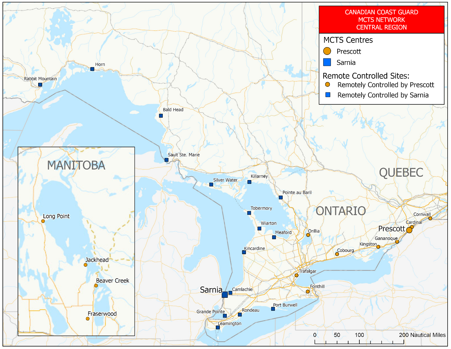
Figure 2-1 - MCTS Network – Central and Arctic Region – Great Lakes
REPLACE WITH THE FOLLOWING:
Figure 2-1 - MCTS Network – Central Region – Great Lakes
Page 2-57
DELETE THE FOLLOWING FIGURE:
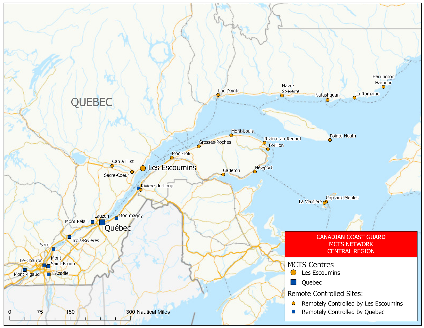
Figure 2-2 - MCTS Network – Central and Arctic Region – Gulf and St. Lawrence River
REPLACE WITH THE FOLLOWING:
Figure 2-2 - MCTS Network – Central Region – Gulf and St. Lawrence River
Page 2-58
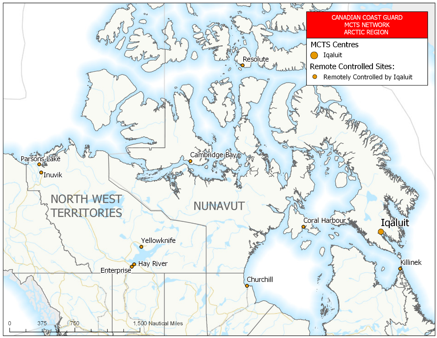
DELETE THE FOLLOWING FIGURE:
Figure 2-3 - MCTS Network – Central and Arctic Region – Arctic
REPLACE WITH THE FOLLOWING:
Figure 2-3 - MCTS Network – Arctic Region
Page 4-41
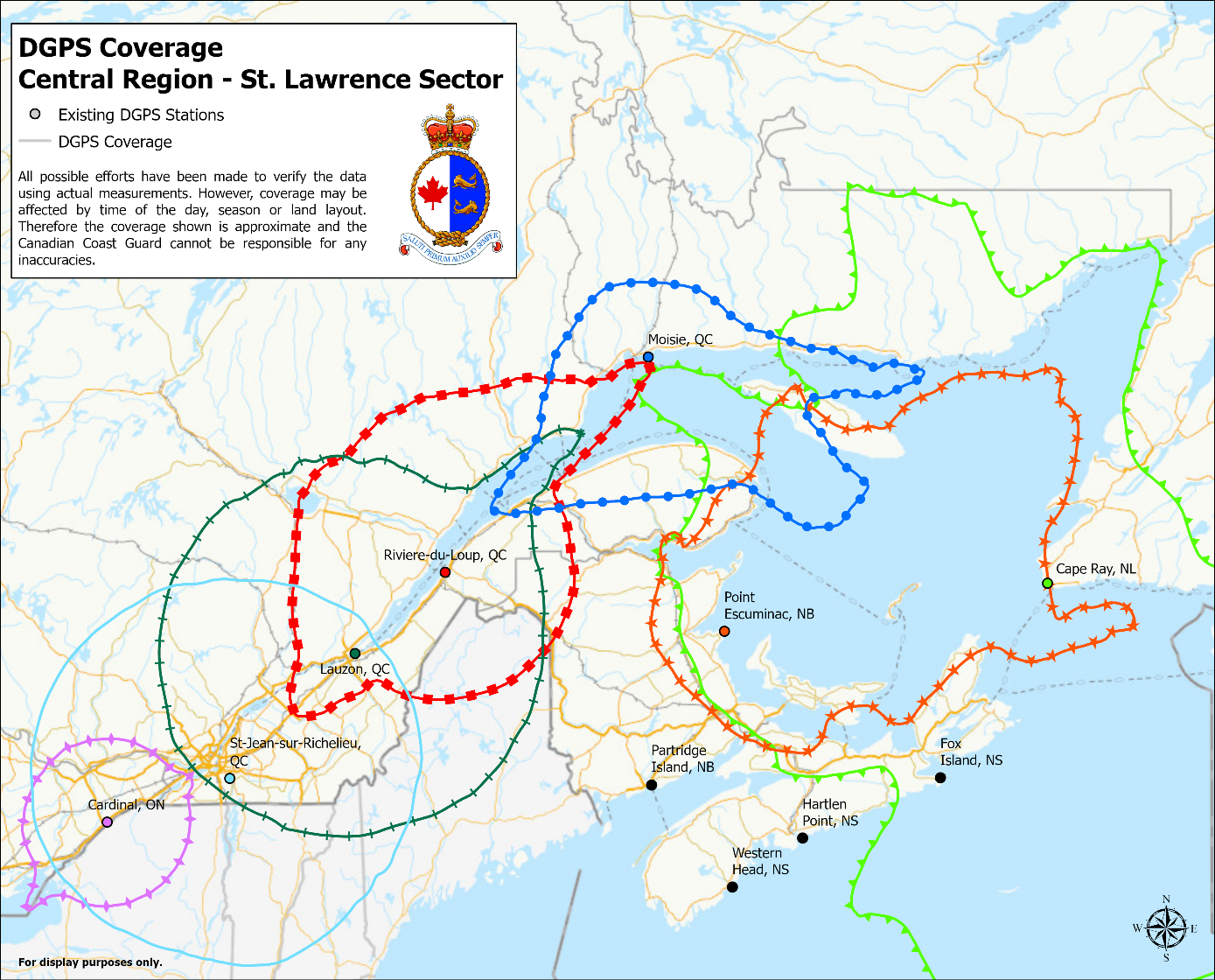
DELETE THE FOLLOWING FIGURE:
Figure 4-8 - DGPS Coverage – Central and Arctic Region - St. Lawrence Sector
REPLACE WITH THE FOLLOWING:
Figure 4-8 - DGPS Coverage – Central Region – St. Lawrence Sector
Page 4-42
DELETE THE FOLLOWING FIGURE:
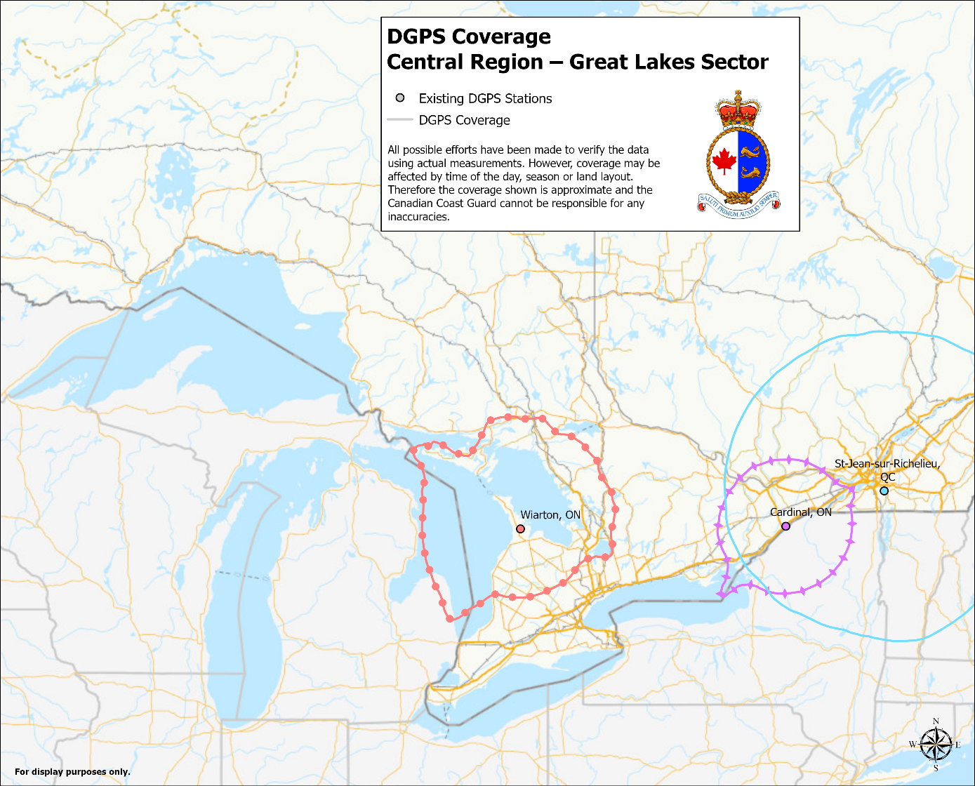
Figure 4-9 - DGPS Coverage - Central and Arctic Region – Great Lakes Sector
REPLACE WITH THE FOLLOWING:
Figure 4-9 - DGPS Coverage - Central Region – Great Lakes Sector
Page 4-47
DELETE THE FOLLOWING TABLE:
Table 4-16 - Distribution of Navigational Warnings
REPLACE WITH THE FOLLOWING:
Table 4-16 - Distribution of Navigational Warnings
|
Designator |
NAVWARN Issuing Desk |
Subscription Service |
Internet
|
|
A and H |
Arctic Region |
X |
|
|
C |
Central Region, Great Lakes Sector |
X |
|
|
Q |
Central Region, St. Lawrence Sector |
X |
|
|
M |
Maritimes Region |
X |
|
|
N |
Newfoundland and Labrador Region |
X |
|
|
P |
Western Region |
X |
Page 4-78
AMEND AS FOLLOWS:
2.To inform a quarantine officer, the person in charge of a vessel shall provide a Maritime Declaration of Health by email at phac.cns-snc.aspc@canada.ca. If this method not be available, a person in charge of a vessel shall provide the following information to the nearest MCTS Centre:
a)the name and
nationality of the vessel;
b)the ports
called at during the vessel voyage;
c)the nature of
the cargo on board the vessel;
d)the number of
persons comprising the crew of the vessel;
e)the number of
passengers on board the vessel;
f)the port of
destination of the vessel and the name of the vessel’s
owner or, if the owner is not in Canada, the name of
the vessel’s agent in Canada;
g)the condition
of all persons on board the vessel and details of any
death or illness occurring during the
voyage;
h)whether the
body of any person is being carried on the
vessel;
i)the estimated
time of arrival of the vessel at the port of
destination; and,
j)the date and place of issuance of any de-ratting certificate or de-ratting exemption certificate applicable to the vessel.
3.Notification is requested 48 hours or greater prior to arrival. Should there be any change in the situation being reported, an updated report must be sent.
4.All Maritime Declarations of Health (new or updated) submitted 24 hours or less prior to arrival, must be accompanied by a call to the CNS at 1-833-615-2384.
Page 4-80
DELETE THE FOLLOWING SECTION:
Ice Central and Arctic
REPLACE WITH THE FOLLOWING:
Ice Central
Canadian Coast Guard Ice
Operations Centre
105 McGill Street,
5th floor
Montreal, QC
H2Y 2E7
Arctic Sector
Telephone:514-283-2784
Email: DFO.IceOpsArctic.GlacesOpsArctique.MPO@dfo-mpo.gc.ca
Ice
conditions
Telephone:514-283-1752
514-283-2069
Email:ec.ssgarctique-issarctic.ec@canada.ca
DFO.IceArctic.GlacesArctique.MPO@dfo-mpo.gc.ca
Great Lakes Sector
Telephone:514-283-2784
Email: DFO.IceOpsGreatLakes.GlacesOpsGrandsLacs.MPO@dfo-mpo.gc.ca
Ice
conditions
Telephone:514-283-1752
514-283-2069
Email:ec.ssggrandslacs-issgreatlakes.ec@canada.ca
DFO.IceGreatLakes.GalcesGrandsLacs.MPO@dfo-mpo.gc.ca
St. Lawrence Sector
Telephone:514-283-1746
Email: DFO.IceOpsStLawrence.GlacesOpsStLaurent.MPO@dfo-mpo.gc.ca
Ice conditions
Telephone:514-283-1752
514-283-2069
Email: ec.ssgstlaurent-issstlawrence.ec@canada.ca
The complete version of JIG TP 15163 B (2011) is available at: http://www.tc.gc.ca/eng/marinesafety/tp-tp15163-menu-4025.htm.
Page 4-84
AMEND AS FOLLOWS:
CCG Central and Arctic Region (Ontario)
Telephone: 613-925-4842
Email: TSCCNA@dfo-mpo.gc.ca
•In the subject of the email, please state: SRI – "Ship's Name"
•In the body of the email, please include any contact information for the vessel.
CCG Central and Arctic Region (Québec)
Fisheries and Oceans Canada
Telephone: 514-283-5684
Email: spvr.email@stericycle.com
SECTION 4 - SAILING DIRECTIONS AND SMALL CRAFT GUIDE CORRECTIONS
ARC 404 — Great Slave Lake and Mackenzie River, First Edition, 2012 —
Chapter 1 — Paragraph 50, after “in Moraine Bay.”
Delete: “The barge is marked with hazard buoys.”
(C2020-012.01)
Chapter 4 — Paragraph 20, last line
Add:Fairway light buoy ME (1173.91) is moored 3.2 miles ENE of the front light of the range.
(A2020-008.9)
Chapter 4 — In the vicinity of paragraph 77
Replace the CORNER BROOK diagram with the new one
provided in Section 4 of this Monthly Edition.
https://www.notmar.gc.ca/publications/monthly-mensuel/images/ed072020-part4-atl109-corner-brook.pdf
(N2020-05.5)
Chapter 4 — Paragraph 155
Delete: “gary.rideout@portharmonauthority.com”
Replace by: dale@portofstephenville.ca
(N2020-05.6)
Chapter 2 — In the vicinity of paragraph 138, Table 2.3 Contrecoeur Terminal Wharves
Make the following change in the “Depth *” column:
| Berth | Depth * |
|---|---|
| metres | |
| 2 | 5.8 |
(Q2020-030.1)
Chapter 2 — Paragraph 31, after “a least depth of 2 feet
[0.6 m]”
Insert: “, and marked by a buoy,”
(C2020-009.1)
Chapter 2 — Paragraph 37, after “Stony Point”
Delete: “(43°52.8′N., 76°15.6′W.)”
Replace by: (43°51′03″N., 76°16′18″W.)
(C2020-009.2)
Chapter 2 — Paragraph 37, after “Stony Point Light”
Delete: “(43°50.3′N., 76°17.9′W.)”
Replace by: (43°50′20″N., 76°17′56″W.)
(C2020-009.3)
Chapter 2 — Paragraph 53, after “marked by a light.”
Insert:The passage between Charity and East Charity Shoals is rendered unsafe by South Charity Shoal, a narrow ridge about 0.9 [0.8] mile SW of East Charity Shoal Light, having a least depth of 11 feet [3.4 m]. The SW extremity of South Charity Shoal is marked by a lighted buoy. About 3.7 [3.2] miles SSW of South Charity Shoal, a detached 25-foot [7.6-m] shoal is marked by a lighted buoy. An unmarked shoal with a least depth of 24 feet [7.3 m] is about 5.5 [4.8] miles SW of South Charity Shoal.
(C2020-009.4)
Chapter 2 — Before paragraph 1
Delete: “Charts 14822, 14832, 14833”
Replace by:ENCs US4NY32M, US5NY34M, US5NY35M, Charts 14822, 14832, 14833
(C2020-010.1)
Chapter 2 — Before paragraph 4
Delete: “Chart 14832”
Replace by: ENC US5NY34M, Chart 14832
(C2020-010.2)
Chapter 2 — After paragraph 13
Delete: “Chart 14833”
Replace by: ENC US5NY35M, Chart 14833
(C2020-010.3)
Chapter 2 — Before paragraph 35
Delete: “Chart 14832”
Replace by: ENC US5NY34M, Chart 14832
(C2020-010.4)
Chapter 2 — Paragraph 78
Delete:“Several small-craft facilities are on Scajaquada Creek, which enters the canal about 0.5 [0.4] mile SE of the lock. Transient berths, gasoline, water, electricity, marine supplies, a launching ramp, a 4-ton [3.6-tonne] mobile crane, and hull and gasoline engine repairs are available. In 1977, 4 feet [1.2 m] was reported available in the approach and alongside the berths.”
(C2020-010.5)
Chapter 2 — Paragraph 84
Delete: “(For a complete description of the port facilities, refer to Port Series No. 41, published and sold by the U.S. Army Corps of Engineers. See Appendix A [of U.S. Coast Pilot 6] for address.)”
Replace by:The depths alongside are reported depths; for the latest depths, contact the operators.
(C2020-010.6)
Chapter 2 — After paragraph 84
Insert:84.1 NRG Energy CR Huntley, Station Coal Wharf (42°58'10"N., 78°55'46"W.): 753 feet [229 m] of berthing space with a depth of 17 feet [5.2 m] alongside and a deck height of 10 feet [3 m]; open storage for 500,000 tons [453,592 t] of coal; receipt of coal for plant consumption; owned and operated by NRG Energy, Inc.
(C2020-010.7)
Chapter 2 — After paragraph 84.1
Insert:84.2 Marathon Ashland Petroleum Tonawanda Terminal Wharf (42°58'39"N., 78°56'22"W.): 1,410 feet [430 m] of berthing space with a depth of 21 feet [6.4 m] alongside and a deck height of 8 feet [2.4 m]; tank storage with a capacity for 110,000 barrels of asphalt; receipt of asphalt by barge; owned and operated by Marathon Ashland Petroleum Co.
(C2020-010.8)
Chapter 2 — After paragraph 84.2
Insert:84.3 NOCO Energy Corp. Tonawanda Terminal Wharf (43°00'03"N., 78°55'45"W.): 400 feet [122 m] of berthing space with a depth of 21 feet [6.4 m] alongside and a deck height of 12 feet [3.7 m]; tank storage with a capacity of 1,066,150 barrels; receipt of petroleum products by barge and tanker; owned and operated by NOCO Energy Corp.
(C2020-010.9)
Chapter 2 — Paragraph 93
Delete:“In 2007, the controlling depth was 12 feet [3.7 m] with lesser depths to 10 feet [3 m] along the edges; the channel is marked by lighted buoys.”
Replace by:The channel is marked by lighted buoys. (See Notice to Mariners and the latest edition of the chart for controlling depths.)
(C2020-010.10)
Chapter 2 — Paragraph 94.1
Delete: “2015, the midchannel”
Replace by: 2016, the
(C2020-010.11)
Chapter 2 — Paragraph 101
Delete: “Charts 14822, 14832,
14833”
Replace by:ENCs US4NY32M, US5NY34M, US5NY35M, Charts 14822, 14832, 14833
(C2020-010.12)
Chapter 2 — Paragraph 103
Delete: “of Bethlehem Steel Corp.”
(C2020-010.13)
Chapter 2 — Paragraph 104
Delete:“A sound signal, which is manually activated by keying the microphone five times on VHF-FM channel 79, is at the light.”
Replace by:A mariner radio-activated sound signal at the light is initiated by keying the microphone five times on VHF-FM channel 83A.
(C2020-010.14)
Chapter 2 — Paragraph 133
Delete: “Chart 14822”
Replace by: ENC US4NY32M, Chart
14822
(C2020-010.15)
Chapter 2 — Delete paragraph 134
(C2020-010.16)
Chapter 2 — Delete paragraph 135
Replace by: 135 A dumping ground extends lakeward from the west side of Stoney Point with a reported least depth of 6 feet [1.8 m] in 1977.
(C2020-010.17)
Chapter 5 — Paragraph 57
Delete: “Charts 14830, 14844,
14842”
Replace by:ENCs US4MI11M, US5MI11M, US5OH10M, US6OH08M, US6OH1AM, US4OH08M, US5OH08M, Charts 14830, 14844, 14842
(C2020-010.18)
Chapter 5 — Paragraph 72, last line
Insert:Passenger ferry service is available to Put-In-Bay. Automobile and passenger ferry service is available to Catawba Island.
(C2020-010.19)
Chapter 5 — Paragraph 75
Delete: “(41°44.4′N., 83°06.4′W.)”
Replace by: (41°44′21″N., 83°06′21″W.)
(C2020-010.20)
Chapter 5 — Paragraph 76
Delete: “Charts 14830, 14844, 14842,
14846”
Replace by:ENCs US4MI11M, US5MI11M, US5OH10M, US6OH08M, US6OH1AM, US4OH08M, US5OH08M, US6MI07M, US6OH07M, US5MI07M, US5OH07M, US5OH1BM, Charts 14830, 14844, 14842, 14846
(C2020-010.21)
Chapter 5 — Paragraph 76, before “Catawba Island and Locust Point”
Delete: “Between”
Replace by: Perry Cove, between
(C2020-010.22)
Chapter 5 — Paragraph 77
Delete: “Charts 14830, 14846,
14847”
Replace by:ENCs US4MI11M, US5MI11M, US6MI07M, US6OH07M, US5MI07M, US5OH07M, US5OH1BM, US5OH31M, Charts 14830, 14846, 14847
(C2020-010.23)
Chapter 5 — Paragraph 81
Delete: “237.4°”
Replace by: 237.6°
(C2020-010.24)
INDEX — After “Pelee Passage, C5/P4”
Insert: Perry Cove, C5/P76
(C2020-010.26)
INDEX — After “Sandusk Creek, C3/P105”
Delete: “Scajaquada Creek, C2/P78”
(C2020-010.25)
Chapter 2 — Before paragraph 151
Delete: “Chart 14882”
Replace by: ENC US5MI61M, Chart 14882
(C2020-011.01)
Chapter 3 — Before paragraph 1
Delete: “Charts 14882, 14883, 14884”
Replace by:ENCs US5MI61M, US5MI62M, US5MI63M, Charts 14882, 14883, 14884
(C2020-011.02)
Chapter 3 — Paragraph 35
Delete : “Chart 14882”
Replace by: ENC US5MI61M, Chart
14882
(C2020-011.03)
Chapter 3 — Paragraph 52
Delete: “Charts 14882,
14883”
Replace by: ENCs US5MI61M, US5MI62M,
Charts 14882, 14883
(C2020-011.04)
Chapter 3 — Paragraph 53
Delete: “Chart 14883”
Replace by: ENCs US5MI62M, US5MI50M,
Chart 14883, 14887
(C2020-011.05)
Chapter 3 — Before paragraph 55
Delete: “Chart 14883”
Replace by: ENC US5MI62M, Chart 14883
(C2020-011.06)
Chapter 3 — Paragraph 80
Delete: “Charts 14883,
14884”
Replace by: ENCs US5MI62M, US5MI63M,
Charts 14883, 14884
(C2020-011.07)
Chapter 3 — Paragraph 85
Delete: “Chart 14884”
Replace by: ENC US5MI63M, Chart
14884
(C2020-011.08)
Chapter 3 — Before paragraph 96
Delete: “Chart 14884”
Replace by: ENC US5MI63M, Chart 14884
(C2020-011.09)
Chapter 4 — Before paragraph 8
Delete: “Charts 14884, 14962”
Replace by:ENCs US4MI77M, US5MI77M, US5MI63M, Charts 14962, 14884
(C2020-011.10)
Chapter 4 — Paragraph 13
Delete: “Chart 14962”
Replace by: ENCs US4MI77M, US5MI77M,
Chart 14962
(C2020-011.11)
Chapter 4 — Before paragraph 23
Delete: “Charts 14884, 14962”
Replace by:ENCs US4MI77M, US5MI77M, US5MI63M, Charts 14962, 14884
(C2020-011.12)
Chapter 4 — Before paragraph 28
Delete: “Chart 14962”
Replace by: ENCs US4MI77M, US5MI77M, Chart 14962
(C2020-011.13)
Chapter 4 — After paragraph 36
Delete: “Charts 14884, 14962”
Replace by:ENCs US4MI77M, US5MI77M, US5MI63M, Charts 14962, 14884
(C2020-011.14)
Chapter 4 — After paragraph 40
Delete: “Chart 14962”
Replace by: ENCs US4MI77M, US5MI77M, Chart 14962
(C2020-011.15)
Chapter 4 — After paragraph 45
Delete: “Chart 14962”
Replace by: ENCs US4MI77M, US5MI77M, Chart 14962
(C2020-011.16)
Chapter 7 — Before paragraph 122
Delete: “Charts 14968, 14976”
Replace by: ENCs US4MN22M, US5MI78M, Charts 14968, 14976
(C2020-011.17)
Chapter 7 — Paragraph 122
Delete
: “Charts 14968,
14976”
Replace by: ENCs US4MN22M, US5MI78M,
Charts 14968, 14976
(C2020-011.18)
SECTION 5 - LIST OF LIGHTS, BUOYS AND FOG SIGNALS CORRECTIONS
The amendments are highlighted and deletions are crossed out. For general and region-specific
information on the List of Lights, click on the following links:
Newfoundland and Labrador Coast,
Atlantic Coast,
Inland Waters and
Pacific Coast.
NEWFOUNDLAND AND LABRADOR COAST
| No. | Name |
Position ----- Latitude N. Longitude W. |
Light Characteristics |
Focal Height in m. above water |
Nominal Range |
Description ----- Height in meters above ground |
Remarks ----- Fog Signals |
|||
|---|---|---|---|---|---|---|---|---|---|---|
FORTUNE BAY (LL 100 – 120.1) |
||||||||||
|
113 H0314 |
Ragged Point Light |
Bay
L’Argent. 47 33 28.0 054 52 34.0 |
Fl | W | 4s | 62.2 | 9 |
Square skeleton tower, red and white rectangular
daymark. 3.8 |
Flash 1 s;
eclipse 3
s. Year round. Chart:4831 Edn 07/20 (N20-038) |
|
WEST COAST (LL 173 – 208.2) |
||||||||||
| 180.61 | Port Harmon East Turning Basin light buoy XS10 |
48 31 34.3 058 31 34.7 |
Fl | R | 4s | ..... | ..... | Red spar, marked “XS10”. |
Year round. Chart:4885 Edn 07/20 (N20-060) |
|
| 193.4 | Lark Harbour Entrance light buoy XL1 |
Bay of
Islands. 49 06 23.2 058 20 36.1 |
Q | G | 1s | ….. | ….. | Green spar, marked “XL1”. |
Seasonal. Chart:4654 Edn 07/20 (N20-061) |
|
STRAIT OF BELLE ISLE (LL 211 – 234) |
||||||||||
| 233.17 | Cooks Harbour Outer light buoy XC6 |
51 36 23.5 055 50 58.5 |
Q | R | 1s | ..... | ..... | Red spar, marked “XC6”. |
Seasonal. Chart:N/A Edn 07/20 (N20-055) |
|
| 233.18 | Cooks Harbour Outer light buoy XC4 |
51 36 30.1 055 50 41.1 |
Fl | R | 4s | ..... | ..... | Red spar, marked “XC4”. |
Seasonal. Chart:N/A Edn 07/20 (N20-056) |
|
WHITE BAY (LL 235 – 269.3) |
||||||||||
| 235.31 | Broize Point light buoy KQ3 |
Griquet Harbour
entrance. 51 32 29.4 055 26 42.2 |
Fl | G | 4s | ..... | ..... | Green spar, marked “KQ3”. |
Seasonal. Chart:4020 Edn 07/20 (N20-066) |
|
NEWFOUNDLAND AND LABRADOR COAST (LL 269.99 – 325.23) |
||||||||||
|
270 H0108 |
Henley Harbour Light (Chateau Point) |
Entrance of
harbour. 51 58 19.9 055 51 11.3 |
Fl | W | 6s | 20.0 | 6 |
Square skeleton tower, red and white rectangular
daymark. 4.3 |
Flash 0.5 s; eclipse 5.5 s. Seasonal. Chart:5030 Edn 07/20 (N20-037) |
|
|
320 H0069 |
White Bear Island Light (Nanuaktok) Racon -. (N) X & S Bands |
55 26 00.7 059 30 40.9 |
Fl | W | 6s | 23.5 | 5 |
Square skeleton tower, red and white rectangular
daymark. 7.6 |
Flash 0.5 s; eclipse 5.5 s. Seasonal. Chart:5046 Edn 07/20 (N20-039) |
|
|
323.3 H0062.5 |
4 Meter Islet Light |
55 57 28.7 060 24 43.5 |
Fl | W | 3s | 7.6 | 7 |
Square skeleton tower, red and white rectangular
daymark. 4.1 |
Flash 0.5 s; eclipse 2.5 s. Seasonal. Chart:5048 Edn 07/20 (N20-042, 086) |
|
NOTRE DAME BAY (LL 326 – 346.4, 354 – 395) |
||||||||||
| 331.9 | Black Rock Sunker light buoy DLB2 |
49 38 11.5 055 45 55.6 |
Fl | R | 4s | ….. | …. | Red spar, marked “DLB2”. |
Seasonal. Chart:4592 Edn 07/20 (N20-058) |
|
|
334 H0677.6 |
Lushes Bight Light |
49 35 18.2 055 43 19.3 |
Fl | W | 6s | 6.4 | 5 |
Square skeleton tower, red and white rectangular
daymark. 4.3 |
Flash 0.5 s; eclipse 5.5 s. Seasonal. Chart:4592 Edn 07/20 (N20-033, 089) |
|
| 341.495 | Moorey Cove Shoal light buoy DR2 |
49 29 42.8 055 47 06.2 |
Fl | R | 4s | ….. | ….. | Red spar, marked “DR2”. |
Seasonal. Chart:4593 Edn 07/20 (N20-057) |
|
|
344 H0670.5 |
Cottrells Cove Light |
49 28 56.5 055 18 16.4 |
Fl | W | 4s | 16.8 | 5 |
Square skeleton tower, red and white rectangular
daymark 4.6 |
Seasonal. Chart:4864 Edn 07/20 (N20-032) |
|
|
369 H0628 |
Ruth Island Light |
E. of Change
Island. 49 40 46.3 054 22 50.7 |
Fl | W | 3s | 10.7 | 5 |
Square skeleton tower, red and white rectangular
daymark. 4.3 |
Flash 1 s; eclipse
2 s. Seasonal. Chart:4862 Edn 07/20 (N20-035) |
|
|
372 H0630 |
Tickle Point Light |
Change
Island. 49 40 07.5 054 24 49.0 |
Fl | G | 5s | 9.4 | 4 |
Square skeleton tower, green and white rectangular
daymark. 4.3 |
Flash 1 s;
eclipse 4
s. Seasonal. Chart:4862 Edn 07/20 (N20-041) |
|
| 372.4 | John Wheaton Rock cautionary light buoy DHJ |
49 33
20.8 054 24 50.2 |
Fl | Y | 4s | ….. | ….. | Yellow, marked “DHJ”. |
Year
round. Chart:4862 Edn 07/20 (N20-053) |
|
| 372.9 | Indian Lookout South Cardinal light buoy DHL |
49 33
21.9 054 19 58.8 |
Q(6) + LFl | W | 15s | ….. | ..... | Yellow and black, marked “DHL”. |
Year round. Chart:4862 Edn 07/20 (N20-052) |
|
|
374 H0606 |
Stag Harbour Run Light |
Fogo
Island. 49 33 18.9 054 17 46.4 |
Fl | W | 4s | 6.0 | 5 |
Square skeleton tower, red and white rectangular
daymark. 4.3 |
Flash 1 s;
eclipse 3 s. Year round. Chart:4530 Edn 07/20 (N20-036) |
|
|
377 H0632 |
Smoker Island Light |
W. of Change
Island. 49 36 41.8 054 27 09.6 |
Fl | W | 4s | 10.7 | ….. |
Square skeleton tower, red and white rectangular
daymark. 5.3 |
Flash 1 s;
eclipse 3
s. Year round. Chart:4862 Edn 07/20 (N20-043) |
|
ATLANTIC COAST
| No. | Name |
Position ----- Latitude N. Longitude W. |
Light Characteristics |
Focal Height in m. above water |
Nominal Range |
Description ----- Height in meters above ground |
Remarks ----- Fog Signals |
|||
|---|---|---|---|---|---|---|---|---|---|---|
NOVA SCOTIA, SOUTHEAST COAST (LL 327 – 684.02) |
||||||||||
|
602 H3534 |
Beaver Island |
E. end of island. 44 49 29.2 062 20 16.0 |
Fl | W | 7s | 19.9 | 14 |
White cylindrical tower with red top. 8.6 |
Year round. Omnidirectional. Chart:4235 Edn 07/20 (F20-025) |
|
GULF OF ST. LAWRENCE (LL 883.2 – 940.3, 1169.1 – 1426, 1477.5 – 1584) |
||||||||||
| 1171 | Miramichi Outer Bar light buoy M4 |
47 05 55.0 064 56 54.0 |
Fl | R | 4s | ….. | ….. | Red spar, marked “M4”. |
Seasonal (in place year round). Chart:N/A Edn 07/20 (G20-081) |
|
| 1172.6 | The Lump light buoy M8 |
47 06 34.4 064 58 25.7 |
Fl | R | 4s | ….. | ….. | Red spar, marked “M8”. |
Seasonal (in place year round). Chart:N/A Edn 07/20 (G20-083) |
|
|
1310 H1580 1311 H1580.1 |
Caraquet range |
| | | | | | | | |
NE. of Stoke Point. 47 48 30.0 064 50 27.8 226°47’ 1091.4 m from front. |
F F |
Y Y |
….. ….. |
8.1 20.3 |
13 13 |
White square tower with red vertical
stripe. 8.2 Square skeleton tower, white daymark with red vertical stripe. 11.3 |
Operates 24
h. Seasonal. Operates 24 h. Seasonal. Chart:4913 Edn 07/20 (G19-120, 121) |
| 1310.5 | Caraquet Channel light buoy EM12 |
47 49
13.5 064 50 01.9 |
Fl | R | 4s | ….. | ….. | Red spar, marked “EM12”. |
Seasonal (in
place year round). Chart:4913 Edn 07/20 (G20-124, 143) |
|
|
1313.2 H1581.5 1313.3 H1581.51 |
Middle Caraquet range |
| | | | | | | | | |
47 48 09.7 064 53 09.0 244°07’ 355.0 m from front. |
F F |
R R |
….. ….. |
8.6 19.6 |
….. ….. |
Square skeleton tower, red daymark with white vertical
stripe. 5.1 Square skeleton tower, red daymark with white vertical stripe. 14.2 |
Operates 24
h. Seasonal. Operates 24 h. Seasonal. Chart:4913 Edn 07/20 (G19-122, 123) |
|
1314.2 H1581.7 1314.3 H1581.71 |
Stoke Point range |
| | | | | | | | | |
47 48 21.4 064 51 34.2 093°46’ 124.2 m from front. |
F F |
R R |
….. ….. |
8.1 12.8 |
14 14 |
Square skeleton tower, red daymark with white vertical
stripe. 3.6 Square skeleton tower, red daymark with white vertical stripe. 8.2 |
Visible in line of range. Operates 24 h. Seasonal. Visible in line of range. Operates 24 h. Seasonal. Chart:4920 Edn 07/20 (G19-124, 125) |
| 1500.5 | Scientific light buoy AZMP-ESG |
46 48
00.0 062 00 00.0 |
Fl(5) | Y | 20s | ….. | ….. | Yellow ODAS, marked “AZMP-ESG”. |
Seasonal. Chart:4023 Edn 07/20 (Q20-123) |
|
| 1561.67 | Chevery cautionary light buoy CA |
Rivière
Nétagamiou entrance. 50 27 31.8 059 36 24.0 |
Fl | Y | 4s | ….. | ….. | Yellow, marked “CA”. |
Seasonal. Chart:4468 Edn 07/20 (Q20-124) |
|
| 1561.68 | Chevery cautionary light buoy CB |
Rivière
Nétagamiou entrance. 50 27 32.3 059 36 34.6 |
Fl | Y | 4s | ….. | ….. | Yellow, marked “CB”. |
Seasonal. Chart:4468 Edn 07/20 (Q20-139) |
|
| 1561.69 | Chevery cautionary light buoy CC |
Rivière
Nétagamiou entrance. 50 27 35.0 059 36 46.1 |
Fl | Y | 4s | ….. | ….. | Yellow, marked “CC”. |
Seasonal. Chart:4468 Edn 07/20 (Q20-125) |
|
PRINCE EDWARD ISLAND (LL 942 – 1084.7) |
||||||||||
| 1044.4 | St. Peters Harbour light buoy JD9 |
46 26 48.2 062 44 17.6 |
Fl | G | 4s | ….. | ….. | Green, marked “JD9”. |
Buoy may be repositioned due to shifting channel. Seasonal. Chart:N/A Edn 07/20 (G20-061) |
|
| 1065.2 | Malpeque West cautionary light buoy JPA |
46 34
30.7 063 39 09.6 |
Fl | Y | 4s | ….. | ….. | Yellow spar, marked “JPA”. |
Seasonal. Chart:4491 Edn 07/20 (G20-096) |
|
| 1065.5 | Malpeque West Entrance light buoy JP6 |
Delete from
list. Chart:4491 Edn 07/20 (G20-095) |
||||||||
ST. LAWRENCE RIVER (LL 1584.5 – 1772, 1823.8 – 2185.7, 2273 – 2365.95) |
||||||||||
| 1994 | Pointe Platon light buoy Q63 |
46 40 40.6 071 51 40.2 |
Fl | G | 4s | ..... | ..... | Green spar, marked “Q63”. |
Year round. Chart:1314 Edn 07/20 (Q20-090) |
|
| 2001 | Rapides Richelieu light buoy Q67 |
NE. of Île Richelieu. 46 39 30.5 071 53 34.0 |
Fl | G | 4s | ..... | ..... | Green spar, marked “Q67”. |
Year round. Chart:1314 Edn 07/20 (Q20-091) |
|
| 2012 | Îlet Mayrand light buoy Q83 |
Grondines. 46 36 28.3 071 58 30.6 |
Fl | G | 4s | ..... | ..... | Green spar, marked “Q83”. |
Year round. Chart:1314 Edn 07/20 (Q20-092) |
|
INLAND WATERS
| No. | Name |
Position ----- Latitude N. Longitude W. |
Light Characteristics |
Focal Height in m. above water |
Nominal Range |
Description ----- Height in meters above ground |
Remarks ----- Fog Signals |
|||
|---|---|---|---|---|---|---|---|---|---|---|
ST. LAWRENCE RIVER SEAWAY (LL 0.05 - 401, 1193 – 1204.5) |
||||||||||
| 10 | Île Saint-Nicolas light buoy A8 |
45 24 21.2 073 44 31.1 |
Fl | R | 4s | ..... | ..... | Red spar, marked “A8”. |
Seasonal (in place year round). Chart:1430 Edn 07/20 (Q20-030) |
|
| 12 | Île Saint-Bernard light buoy A10 |
45 24 19.1 073 45 22.4 |
Fl | R | 4s | ..... | ..... | Red spar, marked “A10”. |
Seasonal (in place year round). Chart:1430 Edn 07/20 (Q20-032) |
|
| 14 | Île Saint-Bernard West Cardinal light buoy LACHINA |
45 24 17.3 073 46 04.7 |
Q(9) | W | 15s | ..... | ..... | Yellow-black-yellow spar, marked “LACHINA”. |
Seasonal (in place year round). Chart:1430 Edn 07/20 (Q20-057) |
|
| 19 | Lac Saint-Louis light buoy A25 |
45 23 10.7 073 48 10.6 |
Fl | G | 4s | ..... | ..... | Green spar, marked “A25”. |
Seasonal (in
place year round). Chart:1430 Edn 07/20 (Q20-051) |
|
| 19.5 | Lac Saint-Louis light buoy A24 |
45 23 15.9 073 48 15.2 |
Fl | R | 4s | ..... | ..... | Red spar, marked “A24”. |
Seasonal (in place year round). Chart:1430 Edn 07/20 (Q20-050) |
|
| 22 | Pointe à Penny light buoy A33 |
45 22 06.5 073 49 38.1 |
Fl | G | 4s | ..... | ..... | Green spar, marked “A33”. |
Seasonal (in place year round). Chart:1430 Edn 07/20 (Q20-052) |
|
| 23 | Pointe à Penny light buoy A34 |
45 22 10.8 073 49 43.8 |
Fl | R | 4s | ..... | ..... | Red spar, marked “A34”. |
Seasonal (in place year round). Chart:1430 Edn 07/20 (Q20-053) |
|
| 23.5 | Îles de la Paix light buoy A35 |
45 21 47.3 073 50 03.2 |
Fl | G | 4s | ….. | ….. | Green spar, marked “A35”. |
Seasonal (in place year round). Chart:1430 Edn 07/20 (Q20-054) |
|
| 24 | Pointe du Moulin light buoy A38 |
45 21 37.2 073 50 29.6 |
Q | R | 1s | ..... | ..... | Red spar, marked “A38”. |
Seasonal (in place year round). Chart:1430 Edn 07/20 (Q20-055) |
|
| 25 | Îles de la Paix light buoy A39 |
45 21 22.1 073 50 36.5 |
Q | G | 1s | ..... | ..... | Green spar, marked “A39”. |
Seasonal (in place year round). Chart:1430 Edn 07/20 (Q20-061) |
|
| 26 | Pointe du Moulin light buoy A40 |
45 21 25.4 073 50 51.5 |
Q | R | 1s | ..... | ..... | Red spar, marked “A40”. |
Seasonal (in place year round). Chart:1430 Edn 07/20 (Q20-059) |
|
| 27 | Îles de la Paix light buoy A45 |
45 20 57.0 073 51 42.4 |
Fl | G | 4s | ..... | ..... | Green spar, marked “A45”. |
Seasonal (in place year round). Chart:1430 Edn 07/20 (Q20-060) |
|
| 29 | Îles de la Paix light buoy A51 |
45 20 29.2 073 52 55.0 |
Q | G | 1s | ..... | ..... | Green spar, marked “A51”. |
Seasonal (in place year round). Chart:1430 Edn 07/20 (Q20-063) |
|
| 30 | Pointe à Péladeau light buoy A52 |
45 20 35.8 073 53 01.2 |
Fl | R | 4s | ..... | ..... | Red spar, marked “A52”. |
Seasonal (in place year round). Chart:1430 Edn 07/20 (Q20-064) |
|
|
37 H2530 37.1 H2530.1 |
Powerhouse range |
| | | | | | | | | |
45 16 41.8 073 55 57.3 046°17' 527.2 m from front. |
Iso F |
G G |
2s ….. |
9.9 22.8 |
13 13 |
White skeleton tower, orange 8.9 White skeleton tower, orange 20.0 |
Seasonal. Seasonal. Chart:1431 Edn 07/20 (B20-007, 008) |
| 80.2 | Valleyfield Harbour Entrance light buoy DV11 |
45 14
55.1 074 09 54.8 |
Fl | G | 4s | ….. | ….. | Green spar, marked “DV11”. |
Operates 24
h. Seasonal. Chart:1431 Edn 07/20 (B20-006) |
|
|
164 H2578 165 H2578.1 |
Cornwall Island range |
| | | | | | | | | | |
E. point of island. 45 00 53.6 074 39 52.0 241°05’ 604.2 m from front. |
F F |
G G |
….. ….. |
19.4 33.0 |
12 12 |
Square
skeleton tower, orange 16.1 15.5 |
Visible in line of range. Seasonal. Visible in line of range. Seasonal. Chart:1433 Edn 07/20 (B20-010, 011) |
GEORGIAN BAY (LL 814 – 982) |
||||||||||
|
866 867 |
Port McNicoll range |
| | | | | | | | | | | |
E. of Elimere Point. 44 45 44.8 079 50 02.2 152°37' 785 m from front. |
F F |
G G |
..... ..... |
21.8 45.6 |
17 17 |
19.2 13.5 |
Operates 24
h. Seasonal (in place year round). Operates 24 h. Seasonal (in place year round). Chart:2241 Edn 07/20 (D18-015, D20-011) |
CANADIAN COAST GUARD - MARINE INFORMATION REPORT AND SUGGESTION SHEET
Name of Ship or Sender:..................................................................... Date:....................................
Address of Sender:..........................................................................................................................
Street # Street Name
Town / City:.............................. Prov / State:....................... Postal Code / Zip Code: ........................
Tel / Fax / E-mail address of sender (if appropriate):............................................................................
Observation Date:............................................. Time (UTC): ...........................................................
Geographical Position:......................................................................................................................
Coordinate Position: Lat: ............................................... Long:.........................................................
Position Method: DGPS GPS with WAAS GPS Radar Other
Horizontal Datum Used: WGS 84 NAD 27 Other
Estimated Position Accuracy:............................................................................................................
Chart #:............................................................ Datum: NAD 27 NAD 83
Chart Edition:.................................................... Last Correction applied:............................................
Publications affected: (Quote edition and page number):.....................................................................
*Full details (Attach additional sheets as necessary):...........................................................................
Mariners are requested to notify the responsible authorities when new or suspected dangers to navigation are discovered, changes are observed in aids to navigation, or corrections to publications are seen to be necessary.
In the case of new or suspected dangers to navigation, it is important that all details be given in order to aid with future investigations. Items of interest include heights, depths, physical description, type of bottom and equipment method used to position the item. It is helpful to mark details on the chart, which will be promptly replaced by the Canadian Hydrographic Service.
Reports should be made to the nearest Marine Communications and Traffic Services Centre (MCTS) and should be confirmed in writing to:
Leader, Notices to Mariners
Canadian Coast Guard
Department of Fisheries and Oceans
Montréal, QC H2Y 2E7
In the case of information concerning aids to navigation or the List of Lights, Buoys and Fog Signals book.
OR
Director General, Canadian Hydrographic Service & Oceanographic Services
Department of Fisheries and Oceans
Ottawa, ON K1A 0E6
In the case of new or suspected dangers to navigation or where corrections to "Sailing Directions" appear to be necessary.
For general questions on Canadian Coast Guard programs or services, please send an e-mail to:
info@dfo-mpo.gc.ca (Please include your postal code and e-mail address).
You can access the online form on the following page: https://www.notmar.gc.ca/incident-en.php or you can use the printable pdf version : https://www.notmar.gc.ca/publications/monthly-mensuel/images/monthly-form-en.pdf