
Archived information
The Standard on Web Usability replaces this content. This content is archived because Common Look and Feel 2.0 Standards have been rescinded.
Archived information is provided for reference, research or recordkeeping purposes. It is not subject to the Government of Canada Web Standards and has not been altered or updated since it was archived.
NOTICES TO MARINERS
PUBLICATION
EASTERN EDITION
May 31, 2019

Safety First, Service Always
Published Monthly by the
CANADIAN COAST GUARD
www.notmar.gc.ca/subscribe/
CONTENTS
| Section 1 | General and Safety Information |
| Section 2 | Chart Corrections |
| Section 3 | Radio Aids to Marine Navigation Corrections |
| Section 4 | Sailing Directions and Small Craft Guide Corrections |
| Section 5 | List of Lights, Buoys and Fog Signals Corrections |
Canadian Coast Guard Programs
Aids to Navigation and Waterways
Fisheries and Oceans Canada
Montreal, Quebec
H2Y 2E7
© Her Majesty the Queen in Right of Canada, 2019
DFO/2019-2028
Fs152-6E-PDF
ISSN 1719-7708
Disponible en français :
Publication des Avis aux navigateurs
Édition de l'Est
Édition mensuelle Nº05/2019
Fisheries and Oceans Canada
Official Publication of the Canadian Coast Guard
DFO/2019-2028
EXPLANATORY NOTES
Geographical positions refer directly to the graduations of the largest scale Canadian Hydrographic chart unless otherwise indicated.
Bearings refer to the true compass and are measured clockwise from 000° (North) clockwise to 359°; those relating to lights are from seaward.
Visibility of lights is that in clear weather.
Depths - The units used for soundings (metres, fathoms or feet) are stated in the title of each chart.
Elevations are normally given above Higher High Water, Large Tide unless otherwise indicated.
Distances may be calculated as follows:
1 nautical mile = 1,852 metres (6,076.1 feet)
1 statute mile = 1,609.3 metres (5,280 feet)
1 metre = 3.28 feet
Temporary & Preliminary Notices are indicated by a (T) or a (P) in Section 1, respectively. Please note that Nautical charts are not amended by the Canadian Hydrographic Service for Temporary (T) and Preliminary (P) Notices. It is recommended that mariners chart these corrections in pencil. The list of charts affected by Temporary and Preliminary Notices are revised and promulgated quarterly in Section 1 of the Monthly Edition.
Please note that, in addition to the temporary and preliminary changes normally advertised as (T) and (P) Notices, there are a few permanent changes to aids to navigation that have been advertised as Preliminary Notices to Mariners while charts are being updated for new editions.
Marine Information Report & Suggestion Sheet
Mariners are requested to notify the responsible authorities when new or suspected dangers to navigation are discovered, changes observed in aids to navigation or corrections to publications are seen
to be necessary. Such communications can be made using the Marine Information Report & Suggestion Sheet inserted on the last
page of each monthly edition of Notices to Mariners.
Canadian Hydrographic Service - Information Published in Section 2 of Notices to Mariners
Mariners are advised that only the most critical changes that directly affect safety to navigation are issued in Section 2 – Chart Corrections. This limitation
is required to ensure that charts remain as clear and easy to read as possible. As a result, mariners may see minor discrepancies of a
non-critical nature between information in official publications. For example, a small change in the nominal range or focal height of a light
may not result in the production of a chart correction in Notices to Mariners, but may result in a correction in the List of Lights, Buoys and
Fog Signals publication.
In case of discrepancy between information provided on CHS charts relating to aids to navigation, and the List of Lights, Buoys and Fog Signals publication, the latter shall be deemed as containing the most up-to-date information.
Canadian Nautical Charts & Publications
A source list of Canadian nautical charts and publications is published in Notice No. 14 of the Notices to Mariners Annual Edition 2019. The source supply and the prices
effective at the time of printing are listed. For current chart edition dates, please refer to the following website:
www.chs-shc.gc.ca/charts-cartes/paper-papier/index-eng.asp
CHART CORRECTIONS - SECTION 2
Corrections to nautical charts will be listed in numerical order by chart number. Each chart correction listed applies only to that particular chart. Related charts, if any, will have their own specific correction listed separately.
Users should also refer to CHS Chart 1: Symbols, Abbreviations and Terms for additional information pertaining to the correction of charts.
The illustration below describes the elements that will comprise a typical Section 2 chart correction:

The last correction number is identified with the LNM/D or Last Notice to Mariners Number / Date.
NOTICES TO MARINERS WEBSITE – MONTHLY EDITIONS, CHART CORRECTIONS, AND CHART PATCHES
The Notices to Mariners website allows users to access the monthly publications,
chart corrections, and chart patches.
Users can subscribe for free to the email notification service
to receive notifications when charts of interest are updated, including their patches, as well as when a new monthly edition becomes available online.
In addition, the monthly publication and related files to download, such as chart patches and Sailing Directions diagrams, can be obtained all together through the download of a single ZIP file.
ADVISORY NAVIGATIONAL WARNINGS / NOTICES TO SHIPPING
The Canadian Coast Guard is implementing a number of changes to the aids to navigation system in Canada.
These changes are advertised as Navigational Warnings, formerly called Notices to ShippingFootnote 1, that are broadcast by the Canadian Coast Guard, and are then followed up with Notices to Mariners, then charts are updated by hand correction, reprints or new editions.
Mariners are advised that all relevant Navigational Warnings (NAVWARNs) should be kept until superseded by Notices to Mariners or through revised charts issued by the Canadian Hydrographic Service (CHS).
Navigational Warnings are accessible on the applicable regional page on the Canadian Coast Guard e-Navigation Maritime Information Portal at http://www.marinfo.gc.ca/e-nav.
The Canadian Hydrographic Service is reviewing the impact of these changes with the Canadian Coast Guard and together are preparing an action plan on the issuing of chart revisions.
For further information, contact your regional Navigational Warning (NAVWARN) Issuing Desk.
Atlantic Region
* Port aux Basques MCTS Centre
Canadian Coast Guard
49 Stadium Rd.
P.O. Box 99
Port aux Basques, NL A0M 1C0
Telephone: (709) 695-2168 or 1-800-563-9089
Facsimile: (709) 695-7784
Email: NAVWARN.MCTSPortAuxBasques@innav.gc.ca
Website: http://www.marinfo.gc.ca/e-nav
Central & Arctic Region
* Prescott MCTS Centre
Canadian Coast Guard
401 King Street West
P.O. Box 1000
Prescott, ON K0E 1T0
“C” and “Q” Series
Telephone: (613) 925-0666
Facsimile: (613) 925-4519
Email: NAVWARN.MCTSPrescott@innav.gc.ca
Website: http://www.marinfo.gc.ca/e-nav
* Sydney MCTS Centre
Canadian Coast Guard
1190 Westmount Road
Sydney, NS B1R 2J6
Telephone: (902) 564-7751 or 1-800-686-8676
Facsimile: (902) 564-7662
Email: NAVWARN.MCTSSydney@innav.gc.ca
Website: http://www.marinfo.gc.ca/e-nav
* Iqaluit MCTS Centre
Operational from approximately mid-May until late December.
Canadian Coast Guard
P.O. Box 189
Iqaluit, NU X0A 0H0
“A” Series
Telephone: (867) 979-5269
“H” Series
Telephone: (867) 979-0310
Facsimile: (867) 979-4264
Email: NAVWARN.MCTSIqaluit@innav.gc.ca
Website: http://www.marinfo.gc.ca/e-nav
* Service available in English and French.
Index
NUMERICAL INDEX OF CANADIAN CHARTS AFFECTED
| 1233 | 4013 | 4403 | 4845 |
| 1234 | 4023 | 4404 | 4846 |
| 1312 | 4025 | 4405 | 4913 |
| 1316 | 4209 | 4406 | 4920 |
| 1317 | 4210 | 4426 | 6411 |
| 1320 | 4235 | 4430 | 6419 |
| 1350 | 4236 | 4440 | 6422 |
| 2047 | 4237 | 4453 | 6423 |
| 3481 | 4241 | 4468 | 6426 |
| 3496 | 4242 | 4593 | 6427 |
| 4003 | 4277 | 4652 | 6432 |
| 4011 | 4320 | 4827 |
SECTION 1 - GENERAL AND SAFETY INFORMATION
TRANSPORT CANADA – RESTRICTED SPEED AREA - ST. CLAIR AND DETROIT RIVERS
Since November 14, 2012, the restricted speed area currently in place as per the St. Clair and Detroit River Navigation Safety Regulations between the Detroit River light and Peche Island light is reduced in size by relocating the southern point of the restricted speed area from its current location at the Detroit River light to a new location at Bar Point light D33. (This notice refers to the previous one published in November 2012 with number *1103.)
GULF OF ST. LAWRENCE – PROTECTION OF THE NORTH ATLANTIC RIGHT WHALE
Due to the changing migratory habits of the North Atlantic Right whale and their increased presence in the Gulf of St. Lawrence, the Government of Canada has put in place seasonal speed restrictions in specified areas. These restrictions are a combination of static zone and dynamic speed reduction sectors. (See map below.)
Description of Measures
In response to consultations with industry and based on
scientific data on North Atlantic Right Whales presence, two
changes have been made to the restriction zone this
year:
oThe southeast corner of the speed restriction zone around Les Îles-de-la-Madeleine has been removed.
oTo help reduce impacts on the marine shipping industry, vessels will be allowed, in the absence of North Atlantic Right Whales sightings, to travel at safe operational speeds in a larger area north of Anticosti Island, extending to the mainland.
Static Zone Coordinates: 47°36'N
062°00'W; 47°10'N 062°30'W; 47°10'N 065°00'W; 50°20'N
065°00'W;
50°20’N 063°00’W;
49°43’N 063°00’W and 49°04’N 062°00’W.
Within the static zone, all
vessels 20 m or more in length over all (LOA) are
instructed to proceed at a speed not exceeding 10.0 knots
over the ground.
Dynamic Sector Coordinates:
Sector A)
49°41’N 065°00’W; 49°20’N
065°00’W; 49°11’N 064°00’W; 49°22’N 064°00’W;
Sector B)
49°22’N 064°00’W; 49°11’N
064°00’W; 48°48’N 063°00’W; 49°00’N 063°00’W;
Sector C)
49°00’N 063°00’W; 48°48’N
063°00’W; 48°24’N 062°00’W; 48°35’N 062°00’W; and
Sector D)
50°16’N 064°00’W; 50°00’N
064°00’W; 49°56’N 063°00’W; 50°16’N 063°00’W.
Within the static zone, there are four dynamic sectors: A, B, C and D. When the Government of Canada has determined that North Atlantic Right Whales do not appear to be present in these sectors, vessels may proceed at a safe operational speed when transiting within these sectors. When North Atlantic Right Whales presence has been determined inside a dynamic sector, vessels 20 m or more in length (LOA) will be notified through a Navigational Warning (NAVWARN) and are required to proceed at a speed not exceeding 10.0 knots over the ground within that sector.
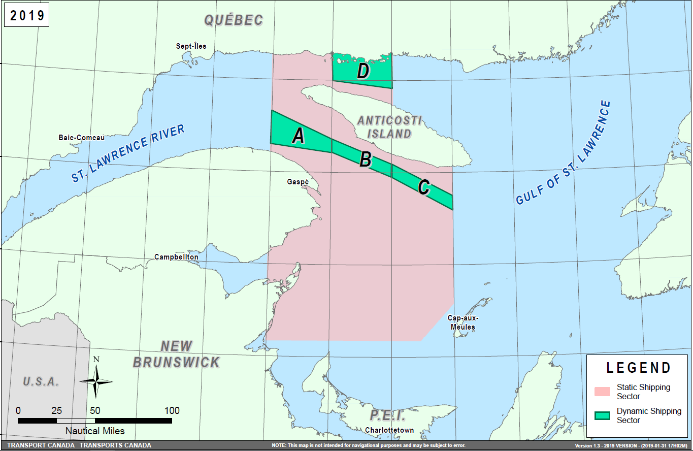
Speed restrictions within the dynamic sectors will be in effect for 15 days, from the date of issuance, and can be extended in the event of continued North Atlantic Right Whales presence. The establishment of speed restriction zones and sectors will be announced through Navigational Warnings.
These restrictions are in effect from April 28 to November 15, 2019. During this period, vessels 20 m or more in length (LOA) shall reduce speed to not exceeding 10.0 knots over the ground in the presence of North Atlantic Right Whales. These dates are subject to change dependent on their presence. Outside of the restriction period, once the mandatory speed restriction has been lifted, vessels are asked to voluntarily reduce their speed to not exceeding 10.0 knots over the ground in the presence of North Atlantic Right Whales, only if maritime conditions permit safe operation of their vessel at that speed.
Navigational Warnings (NAVWARNs) Broadcasts
The Canadian Coast Guard (CCG) continues to promulgate valid Navigational Warnings via radio broadcasts over various terrestrial systems and also online at http://www.marinfo.gc.ca/e-nav or http://nis.ccg-gcc.gc.ca. Mariners shall ensure that they have correct and up-to-date information concerning the protection of the North Atlantic Right Whales as contained in all applicable Notices to Mariners (NOTMARs) and Navigational Warnings.
Canada has replaced its Notice to Shipping (NOTSHIP) with Navigational Warnings (NAVWARNs). NOTSHIPs are no longer being issued. Mariners and other users will be able to search for NAVWARNs, or subscribe to receive NAVWARNs by email, by visiting the following web page: http://nis.ccg-gcc.gc.ca/public/rest/messages/en/search.
Until updates are completed to Canadian nautical charts and publications, Notice to Shipping or NOTSHIPs will continue to be referenced. All references to Notices to Shipping and to NOTSHIPs must be read as meaning Navigational Warnings or NAVWARNs.
Notices to Mariners (NOTMARs) will still be issued as usual and can be searched by visiting the following web page: https://www.notmar.gc.ca/monthly-mensuel-en.php.
Aids to Navigation
In addition, CCG continues to test the use of virtual Automatic Identification System aids to navigation (AIS AtoN), referred in NOTMAR 819(T)/2016. These aids will notify a mariner of a dynamic sector that is subject to a speed restriction. Each dynamic sector will be delimited by four virtual AIS AtoN which could be displayed on the ship’s navigation equipment such as: ECDIS, ECS, RADAR, Minimum Keyboard Display, and Electronic Nautical Charts. The virtual AIS AtoN will be broadcasted only when a speed restriction is in effect in one or more sectors. The mariner is required to select the virtual AIS AtoN symbol to view a message as such: “SectA1 Spd Lim 10 kt.” This message refers to a speed restriction in effect for a specific sector. As this system continues to be in the testing phase, it is not the primary means of communicating with the mariner.
Compliance and Enforcement
Navigational Warnings shall be construed as Notices to Shipping, which must be complied with under section 7 of the Collision Regulations. Failure to comply with any instructions and directions contained in Navigational Warnings could lead to either administrative monetary penalties ranging from Can$6,000 to Can$25,000, or penal sanctions under the Canada Shipping Act, 2001.
If vessels appear to have violated the speed restriction, Transport Canada Marine Safety Inspectors will review all information provided through AIS and seek information from the master. Exemptions to the speed restrictions will not be granted in advance; however, factors such as navigation to ensure vessel safety, weather conditions, force majeure (unforeseen circumstances) and responding to emergencies, will be reviewed and considered by Transport Canada.
Reporting of Whale Sightings
If you see a North Atlantic Right Whale that is entangled, dead, or injured, please report it to your nearest Canadian Coast Guard Marine Communications and Traffic Services Centre, or as follows:
•For the southern part of the Gulf of St. Lawrence:
–Marine Animal Response Society at 1-866-567-6277
•For Newfoundland and Labrador:
–Whale Release and Strandings at 1-709-895-3003
•For the Québec sector:
–Marine Mammal emergencies at 1-877-722-5346
Sightings of live, free-swimming whales should be reported by phone to 1-902-440-8611 (local) or 1-844-800-8568 (toll free) or by email at xmarwhalesightings@dfo-mpo.gc.ca.
SAGUENAY–ST. LAWRENCE MARINE PARK AND SURROUNDING WATERS – WHALE PROTECTION
The waters in and around the Saguenay–St. Lawrence Marine Park are well known for the resident endangered beluga population and the wide diversity of whales that migrate there to feed, particularly between April and November.
REGULATORY PROTECTION MEASURES
All whale species that are found in the St. Lawrence are protected under the Marine Mammal Regulations, pursuant to the Fisheries Act. Within the boundaries of the Marine Park, specific measures are set out in the Marine Activities in the Saguenay–St. Lawrence Marine Park Regulations, pursuant to the establishment of the Saguenay–St. Lawrence Marine Park Act. Any collision with a marine mammal within the Marine Park must immediately be reported to a park warden at 1-866-508-9888. For collisions that occur outside the Marine Park or for any situation involving a marine mammal that is dead or in trouble, contact the emergency network at 1-877-722-5346 or on VHF channel 16.
For more information on the Saguenay–St. Lawrence Marine Park, see notice 5C of the Notices to Mariners Annual Edition 2019.
VOLUNTARY PROTECTION MEASURES
Provisional measures in effect from May 1 to October 31, 2019. See map at the end of this notice.
These measures apply to merchant vessels and cruise ships between Pointe à Boisvert and Cap de la Tête au Chien to prevent collisions with whales. These measures should only be taken when they will not jeopardize navigational safety.
Caution area (yellow area): To reduce the risk of collisions with whales that can be present anywhere in this area, heightened vigilance of navigators is critical. Posting a lookout is recommended in order to increase the chances of seeing the whales and thus taking necessary measures to avoid them. If bypassing the whales is not possible, slow down and wait for the animals to move away to a distance greater than 400 metres (0.215 nautical miles) before resuming original speed. It is more difficult to see the animals at night therefore increased caution is recommended.
Slow down to 10 knots or less area (red area): To reduce the risk of collisions with whales in this feeding area, it is recommended that vessels slow down to a maximum speed through the water of 10 knots and post a lookout. It is further recommended to remain in the Laurentian Channel to the north of Île Rouge to minimize the impact of noise in a sensitive area south of this island, which is highly frequented by herds of beluga whales composed of females and young.
Area to be avoided (hatched red area): To reduce noise and the risk of collisions with whales, vessels should avoid transiting through this area which is highly frequented by blue whales, an endangered species. If the area cannot be avoided, slow down to a speed through the water of 10 knots or less.

SAGUENAY–ST. LAWRENCE MARINE PARK – BELUGA WHALE PROTECTION: SLOWDOWN AREA AT THE MOUTH OF THE SAGUENAY FJORD AND AREA CLOSURE AT BAIE SAINTE-MARGUERITE
The Saguenay–St. Lawrence Marine Park and its surrounding area are at the heart of endangered beluga whale critical summer habitat. Marine mammal protection measures have been put in place in accordance with the Marine Activities in the Saguenay–St. Lawrence Marine Park Regulations within the limits of the Marine Park.
However, important feeding, calving and rearing areas for beluga whales require greater protection to ensure the recovery of the species. The portion of the Saguenay situated between the mouth of the Fjord and Baie Sainte-Marguerite is one of the areas most used by females and their young from May to October. The mouth of the Saguenay is known as a feeding ground and Baie Sainte-Marguerite as a calving and rearing area.
In order to prevent collisions with beluga whales, a compulsory 15-knot slowdown area is in effect from May 1st to October 31st at the mouth of the Saguenay. To ensure tranquility for female belugas and their young during the critical calving period, access to Baie Sainte-Marguerite is prohibited to all vessels from June 21st to September 21st, except for special authorizations (see description below).
For safety reasons, these measures do not apply to cargo ships (see the monthly edition of Notice to Mariners from May to October for voluntary protection measures in the St. Lawrence Estuary). An enhanced vigilance is, however, recommended to all navigators between the mouth of the Saguenay Fjord and Baie Sainte-Marguerite for the protection of beluga whales.
For more information on the Saguenay–St. Lawrence Marine Park, see notice 5C of the Notices to Mariners Annual Edition 2019 or visit http://parcmarin.qc.ca/home/.
REGULATORY PROTECTION MEASURES — BELUGA WHALE
Entire Marine Park Territory:
•When beluga whales are less than half a nautical mile (926 metres) from a motorized vessel, the vessel must maintain a speed of between 5 and 10 knots.
•All vessels, including human-powered vessels (kayaks and canoes), must continue to move forward and maintain their heading.
•All vessels must maintain a minimum distance of 400 metres from beluga whales at all times.
For more information concerning the regulations, consult: http://marinepark.ca/protect/#regulations.
Mouth of the Saguenay Fjord (Figure 1) — Slowdown Area (area cross-hatched in red):
•Maximum
speed at the mouth of the Saguenay between buoys S7 and S8
and the ferry docks between
Baie-Sainte-Catherine and Tadoussac is 15 knots
from May 1st to October
31st.
Baie Sainte-Marguerite (Figure 2) — Area Closure (red area):
•From June 21st to September 21st, vessels must not enter the red area, which follows a line between Cap Nord-Ouest and Cap Sainte-Marguerite.
•Special authorizations are granted only for kayaks, canoes and recreational fishermen who must travel without stopping along a corridor within 10 metres of the shore or in shallow areas.
VOLUNTARY PROTECTION MEASURES
Baie Sainte-Marguerite sector (Figure 2) — Transit Area (area cross-hatched in yellow):
•From June 21st to September 21st, navigation in this area is recommended at a speed of between 5 and 10 knots without stopping.
The purpose of this transit area is to favour respect of the Marine Activities in the Saguenay–St. Lawrence Marine Park Regulations, since beluga whales are often present in the Baie Sainte-Marguerite sector.
INFORMATION
All incidents, including collisions with whales, must be reported without delay by dialling 1-866-508-9888. For any other situation concerning a marine mammal that is either dead or in trouble, contact the emergency network at 1-877-722-5346, or use VHF channel 16.
Figure 1

Figure 2

*501 CANADIAN HYDROGRAPHIC SERVICE – NAUTICAL CHARTS
|
CHARTS |
MAIN TITLE |
SCALE |
PUBLISHED |
CAT# |
PRICE |
|---|---|---|---|---|---|
|
New Editions |
|||||
|
1312 |
Lac Saint-Pierre |
1:40 000 |
10-MAY-2019 |
1 |
20.00 |
|
2047 |
Clarkson Harbour |
1:7 500 |
03-MAY-2019 |
3 |
12.00 |
|
Charts Permanently Withdrawn |
|||||
|
3481 |
Approaches to/Approches à Vancouver Harbour |
||||
*502 CANADIAN HYDROGRAPHIC SERVICE – ELECTRONIC NAVIGATIONAL CHARTS
|
S-57 ENC NUMBER |
CHART TITLE |
|---|---|
|
NEW PRODUCTS |
|
|
CA373489 |
Puvirnituq et les approches / and Approches |
|
CA473497 |
Coral Harbour and Approaches/et les approches |
|
CA476735 |
Ticoralak Island to/à Green Island |
|
CA576737 |
Rigolet |
|
CA670734 |
Crofton |
|
WITHDRAWN PRODUCTS |
|
|
CA573373 |
Puvirnituq |
*503 CANADIAN HYDROGRAPHIC SERVICE – RASTER DIGITAL CHARTS (BSB V3)
|
CHARTS |
MAIN TITLE |
SCALE |
PUBLISHED |
|---|---|---|---|
|
New Editions |
|||
|
RM-1312 |
Lac Saint-Pierre |
1:40 000 |
10-MAY-2019 |
|
RM-1313 |
Batiscan au/to Lac Saint-Pierre |
1:40 000 |
08-MAR-2019 |
|
RM-1314 |
Donnacona à/to Batiscan |
1:40 000 |
15-MAR-2019 |
|
RM-2047 |
Clarkson Harbour |
1:7 500 |
03-MAY-2019 |
|
Charts Permanently Withdrawn |
|||
|
RM-3481 |
Approaches to/Approches à Vancouver Harbour |
||
*504 TRANSPORT CANADA – SHIP SAFETY BULLETINS #06, 07, 08 AND 09/2019
New Ship Safety Bulletins have recently been posted to the Transport Canada website at www.tc.gc.ca/ssb-bsn/.
To view or download these bulletins, please click on the links below:
SSB#06/2019
– Launch of a new Small Vessel Compliance Program for
Fishing Vessels not more than 15 Gross Tonnage
RDIMS#14071943
SSB#07/2019
– Protecting the North Atlantic right whale: Speed
restriction measures in the Gulf of
St. Lawrence
RDIMS#14969660
SSB#08/2019
– New Insurance Requirements for Wreck
Removal
RDIMS#15209221
SSB#09/2019
– Expanding AIS Requirements
RDIMS#15282379
Sign yourself up for e-Bulletin to receive an e-mail notice each time a new Ship Safety Bulletin is published on our website.
Contact us at marinesafety-securitemaritime@tc.gc.ca or 1-855-859-3123 (Toll Free).
*505 CANADIAN COAST GUARD PUBLICATION – AMENDMENTS TO NOTICES TO MARINERS ANNUAL EDITION 2019 - SECTION A2, NOTICE 5A: GENERAL REGULATORY REQUIREMENTS FOR ALL OCEANS ACT MARINE PROTECTED AREAS
Page 13:
ADD THE FOLLOWING AT THE BEGINNING OF THE PAGE:
1.7The Banc-des-Américains Marine Protected Area
The Banc-des-Américains Marine Protected Area Regulations, under the Oceans Act, were published on March 6, 2019. The full text of the regulations designating this area can be found in the Canada Gazette, Part II, Vol. 153, No. 5, 439-481 (http://canadagazette.gc.ca).
These Regulations constitute the federal portion of the joint Banc-des-Américains Marine Protected Area project, created under the Canada-Quebec collaborative agreement for establishing a marine protected areas network in Quebec and the specific Agreement for this project, signed on March 4, 2019.
Coordinates
The Regulations establish two management zones within the MPA:
Zone 1 (core protection zone): This zone covers an area of 127 km2. It covers all of the rocky ridges associated with the American Bank, as well as their escarpments and the surrounding sea floor.
Zones 2a and 2b (adaptive management zone): These zones cover an area of 873 km2 and include almost 90% of the MPA. They include the deep plains on either side of the American Bank.
The Banc-des-Américains Marine Protected Area (1,000
km2) is bounded by rhumb
lines connecting the following geographical coordinates
(points 1 to 16) [North American Datum 1983 (NAD 83)]. Zone 1
is bounded by a series of rhumb lines drawn from point 1
to point 5, then to points 6 to 16 and then back to
point 1. Zone 2a is bounded by a series of rhumb lines
drawn from point 5 to point 2, then to point 3, then to point
11, then to point 10, then to point 9, then to point 8, then
to point 7, then to point 6 and then back to point 5. Zone 2b
is bounded by a series of rhumb lines drawn from point 16 to
point 15, then to point 14, then to point 13, then to point
12, then to point 4 and then back to point
16.
|
Point |
Latitude (North) |
Longitude (West) |
|---|---|---|
|
1 |
48° 45' 00.00ʺ |
64° 08' 24.00ʺ |
|
2 |
48° 45' 00.00ʺ |
63° 40' 15.00ʺ |
|
3 |
48° 29' 24.00ʺ |
63° 40' 15.00ʺ |
|
4 |
48° 29' 24.00ʺ |
64° 08' 24.00ʺ |
|
5 |
48° 45' 00.13ʺ |
64° 07' 16.48ʺ |
|
6 |
48° 37' 13.33ʺ |
63° 55' 28.47ʺ |
|
7 |
48° 37' 19.43ʺ |
63° 54' 33.91ʺ |
|
8 |
48° 36' 28.92ʺ |
63° 53' 17.65ʺ |
|
9 |
48° 34' 54.11ʺ |
63° 54' 06.36ʺ |
|
10 |
48° 30' 24.46ʺ |
63° 47' 20.43ʺ |
|
11 |
48° 29' 24.73ʺ |
63° 48' 51.44ʺ |
|
12 |
48° 29' 24.76ʺ |
63° 49' 23.91ʺ |
|
13 |
48° 33' 25.72ʺ |
63° 55' 26.76ʺ |
|
14 |
48° 34' 38.52ʺ |
63° 58' 02.08ʺ |
|
15 |
48° 37' 04.16ʺ |
63° 58' 48.70ʺ |
|
16 |
48° 43' 23.21ʺ |
64° 08' 24.00ʺ |
The Banc-des-Américains Marine Protected Area is shown in the map below:
Regulatory Requirements for Vessels Operating in the Banc-des-Américains Marine Protected Area
•See Section 5A – General Regulatory Requirements for all Oceans Act Marine Protected Areas.
•Specific requirements for the Banc-des-Américains Marine Protected Area
oAll activities related to shipping and transportation continue to be allowed within the MPA. However, anchoring of vessels is not permitted in Zone 1. In addition, discharge of sewage and release of grey water (as defined in the Vessel Pollution and Dangerous Chemicals Regulations) from vessels with a gross tonnage of 400 tonnes or more, or certified to carry 15 or more passengers, are prohibited in the MPA.
Guidelines for Vessels Operating in the Area (Year Round)
It is recommended that the following guidelines be followed to safeguard the Marine Protected Area and its resources.
Marine Mammal Protection
1.Vessels must comply with all relevant provisions of the Marine Mammal Regulations under the Fisheries Act. Further details can be found in Section 5 – General Guidelines for Aquatic Species at Risk and Important Marine Mammal Areas.
2.Report all collisions with marine mammals or turtles, entanglements of marine mammals or turtles and animals in distress or those found dead by calling the toll-free number of the Réseau québécois d'urgences pour les mammifères marins (1-877-722-5346). Before releasing a whale carcass caught in fishing gear, it is important to contact the emergency service.
N.B. In this document, the term “Banc-des-Américains” is used to refer to the marine area that is designated as a Marine Protected Area, while the term “American Bank” is used to refer to the underwater bank (i.e. the physical structure) in the Gulf of St. Lawrence.
*506 CANADIAN COAST GUARD PUBLICATION - AMENDMENTS TO NOTICES TO MARINERS ANNUAL EDITION 2019 – SECTION A6, NOTICE 13: CHARTS AND NAUTICAL PUBLICATIONS REGULATIONS 1995, AND PROVISIONAL LIST OF CHARTS
Page 15:
AMEND
25.Arriving Vancouver, British Columbia
|
CANADIAN CATALOGUE |
U.S.A CATALOGUE |
U.K. CATALOGUE |
|||
|---|---|---|---|---|---|
|
Chart |
ENC |
Title |
Scale 1: |
Chart |
Chart |
|
3481 |
CA470072 |
Approaches to/Approches à Vancouver Harbour |
25,000 |
4962 |
|
TO READ
25.Arriving Vancouver, British Columbia
|
CANADIAN CATALOGUE |
U.S.A CATALOGUE |
U.K. CATALOGUE |
|||
|---|---|---|---|---|---|
|
Chart |
ENC |
Title |
Scale 1: |
Chart |
Chart |
|
3496 |
CA570747 |
Approaches to/Approches à Vancouver Harbour |
12,000 |
|
|
Page 18:
AMEND
33.Inner Passages, British Columbia, Vancouver to Portland Canal
|
CANADIAN CATALOGUE |
U.K. CATALOGUE |
|||
|---|---|---|---|---|
|
Chart |
ENC |
Title |
Scale 1: |
Chart |
|
3481 |
CA470072 |
Approaches to/Approches à Vancouver Harbour |
25,000 |
4962 |
TO READ
33.Inner Passages, British Columbia, Vancouver to Portland Canal
|
CANADIAN CATALOGUE |
U.K. CATALOGUE |
|||
|---|---|---|---|---|
|
Chart |
ENC |
Title |
Scale 1: |
Chart |
|
3496 |
CA570747 |
Approaches to/Approches à Vancouver Harbour |
12,000 |
|
*507 CANADIAN COAST GUARD PUBLICATION – MODIFICATIONS TO THE SECTIONS AND SUB-SECTIONS IN THE LIST OF LIGHTS, BUOYS AND FOG SIGNALS
Please note that the sections and sub-sections in the List of Lights, Buoys and Fog Signals volumes have been modified to reflect the official geographical names according to Natural Resources Canada.
In addition, other changes have been implemented during the revision of the sections and sub-sections of the publication. Please refer to the table below for a complete list of affected sections and actions taken.
|
Volume |
List of Lights # |
Affected Sections |
Actions Taken |
|---|---|---|---|
|
Atlantic Coast |
1 - 509 |
Newfoundland |
Deleted as content is located in the Newfoundland and Labrador Coast Volume. |
|
80 - 99 |
Saint-Pierre and Miquelon |
Deleted as original section is located in the Newfoundland and Labrador Coast Volume. |
|
|
114.5 – 141.5 |
Saint John River |
Name of the sub-section “Belleisle Bay” deleted as there are no listed aids related to this area. |
|
|
666 |
Sable Island, N.S. |
Deleted as section is empty. |
|
|
2503 - 2540 |
Mackenzie River – Mackenzie Bay |
Deleted as original section is located in the Inland Waters Volume. |
|
|
2545 - 2621 |
Hudson Strait and Bay |
Deleted as original section is located in the Inland Waters Volume. |
|
|
Pacific Coast |
2503 - 2540 |
Mackenzie River – Mackenzie Bay |
Deleted as original section is located in the Inland Waters Volume. |
|
2545 - 2621 |
Hudson Strait and Bay |
Deleted as original section is located in the Inland Waters Volume. |
*508 CANADIAN HYDROGRAPHIC SERVICE – FREE DOWNLOADABLE SAILING DIRECTIONS NOW AVAILABLE
The Sailing Directions booklets are an indispensable companion to nautical charts. They are a great tool for planning and assisting in navigation because they provide information that cannot be shown on a chart.
All hard copy Print on Demand (POD) Sailing Directions booklets are being printed with current Notices to Mariners updates applied. These POD booklets are available for purchase from authorized chart dealers located across Canada and around the world.
Important note
It is the mariners' responsibility to maintain their digital Sailing Directions file by ensuring that the latest version is always downloaded. If the mariner chooses to print their own Sailing Directions booklet, it is imperative that the current Notices to Mariners updates are applied. Please check this page by the 15th of the month to verify the last update date for the booklet that has been downloaded, and download a new copy as required. Do not leave port without it!
To access the free downloadable updated pdf files, please click on the link below:
http://charts.gc.ca/publications/sailingdirections-instructionsnautiques-eng.asp
*510 ÎLE DU BIC AU/TO CAP DE LA TÊTE AU CHIEN – DAYBEACONS PERMANENTLY DISCONTINUED
Reference Chart: 1320
The following daybeacons have been permanently discontinued:
Île Verte port daybeacon (LL
6764.511): 48° 02’ 02.0”N 069°
21’ 24.3”W
Île Verte starboard daybeacon
(LL 6764.512): 48° 02’ 00.6”N 069°
21’ 30.0”W
Île Verte port daybeacon (LL
6764.513): 48° 01’ 58.2”N 069°
21’ 18.3”W
Île Verte starboard daybeacon
(LL 6764.514): 48° 01’ 55.7”N 069°
21’ 23.1”W
Île Verte port daybeacon (LL
6764.515): 48° 01’ 55.0”N 069°
21’ 13.7”W
Île Verte starboard daybeacon
(LL 6764.516): 48° 01’ 52.7”N 069°
21’ 18.3”W
Île Verte port daybeacon (LL
6764.517): 48° 01’ 52.1”N 069°
21’ 10.0”W
Île Verte starboard daybeacon
(LL 6764.518): 48° 01’ 50.1”N 069°
21’ 14.5”W
Île Verte port daybeacon (LL
6764.519): 48° 01’ 48.6”N 069°
21’ 06.0”W
Île Verte starboard daybeacon
(LL 6764.52): 48° 01’ 46.9”N 069°
21’ 11.1”W
Île Verte port daybeacon (LL
6764.521): 48° 01’ 45.4”N 069°
21’ 03.0”W
Île Verte starboard daybeacon
(LL 6764.522): 48° 01’ 43.7”N 069°
21’ 08.5”W
Île Verte port daybeacon (LL
6764.523): 48° 01’ 41.7”N 069°
21’ 00.8”W
Île Verte starboard daybeacon
(LL 6764.524): 48° 01’ 40.1”N 069°
21’ 06.0”W
Île Verte port daybeacon (LL
6764.525): 48° 01’ 36.7”N 069°
20’ 58.0”W
Île Verte starboard daybeacon
(LL 6764.526): 48° 01’ 35.7”N 069°
21’ 03.2”W
Île Verte port daybeacon (LL
6764.527): 48° 01’ 34.1”N 069°
20’ 56.7”W
Île Verte starboard daybeacon
(LL 6764.528): 48° 01’ 32.7”N 069°
21’ 01.1”W
Île Verte starboard daybeacon
(LL 6764.5288): 48° 01’ 30.8”N 069°
21’ 00.1”W
Île Verte starboard daybeacon
(LL 6764.53): 48° 01’ 29.4”N 069°
20’ 59.9”W
Île Verte starboard daybeacon
(LL 6764.5308): 48° 01’ 28.8”N 069°
20’ 59.8”W
Île Verte starboard daybeacon
(LL 6764.532): 48° 01’ 27.1”N 069°
20’ 54.8”W
Île Verte starboard daybeacon
(LL 6764.5328): 48° 01’ 26.9”N 069°
20’ 53.7”W
Île Verte starboard daybeacon
(LL 6764.534): 48° 01’ 26.8”N 069°
20’ 52.9”W
Île Verte starboard daybeacon
(LL 6764.5348): 48° 01’ 26.7”N 069°
20’ 51.8”W
(Q2019-027 to 051)
*511 CARAQUET HARBOUR, BAIE DE SHIPPEGAN AND / ET MISCOU HARBOUR – UNLIT BUOY REPOSITIONED
Reference Chart: 4913
The following unlit buoy has been permanently repositioned:
Caraquet Harbour Buoy EN6 (LL 6320.6): 47° 48’ 53.8”N 064° 54’ 21.5”W
(G2019-028, 031,
037)
*512(P) GREAT BRAS D'OR, ST. ANDREWS CHANNEL AND/ET ST. ANNS BAY – FOG SIGNAL TO BE PERMANENTLY DISCONTINUED
Reference Chart: 4277
The Canadian Coast Guard proposes to permanently discontinue the fog signal on the following aid to navigation:
Black Rock Point
(LL 799) (46° 18’
18.8”N 060°
23’ 29.8”W): The light and structure
to remain.
Comments on this action are solicited from mariners and other interested parties by August 31, 2019, three months following the initial publication date of May 31, 2019. Following this date, this notice will be cancelled. Comments should be directed to the following:
Superintendent, Renee
Pope
Aids to Navigation and
Waterways
Canadian Coast Guard
P.O. Box 5667
St. John’s, NL A1C 5X1
Telephone: (709)
772-2800
Email:
renee.pope@dfo-mpo.gc.ca
Any objections raised must state the facts on which they are based and should include supporting information on safety, commerce and public benefit.
(G2019-038)
*513(P) PICTOU ISLAND TO / AUX TRYON SHOALS – NOTICE OF PROPOSED CHANGES
Reference Chart: 4405
The Canadian Coast Guard proposes to permanently change the following aids to navigation:
|
LL # |
Aid Name |
Position |
Proposed Changes |
|---|---|---|---|
|
1008.1 |
Victoria Harbour |
46° 12’
50.8”N |
Discontinue aid. |
|
1008.2 |
Victoria Harbour
|
N/A |
Establish new light in position 46°
12.746’N |
Comments on this action are solicited from mariners and other interested parties by August 31, 2019, three months following the initial publication date of May 31, 2019. Following this date, this notice will be cancelled. Comments should be directed to the following:
Superintendent, Renee
Pope
Aids to Navigation and
Waterways
Canadian Coast Guard
P.O. Box 5667
St. John’s, NL A1C 5X1
Telephone: (709)
772-2800
Email:
renee.pope@dfo-mpo.gc.ca
Any objections raised must state the facts on which they are based and should include supporting information on safety, commerce and public benefit.
(G2019-040)
*514(P) RIVIÈRE RISTIGOUCHE / RESTIGOUCHE RIVER – NOTICE OF PROPOSED CHANGES
Reference Chart: 4426
The Canadian Coast Guard proposes to permanently change the following aids to navigation:
|
Fixed Aids |
|||
|---|---|---|---|
|
LL # |
Aid Name |
Position |
Proposed Changes |
|
1343 |
Inch Arran Point
|
48° 03’
39.4”N |
Increase intensity of lantern. |
|
1343.1 |
Inch Arran Point
|
286°45’ 364.5 m from front. |
Increase intensity of lantern. Change flash characteristics to Iso 6s operating 24 h. |
|
1343.6 |
Dalhousie Wharf |
48° 04’
17.8”N |
Decrease intensity of lantern. |
|
1343.7 |
Dalhousie Harbour East range front |
48° 04’
15.2”N |
Change flash characteristics to fixed. Decrease intensity of lantern. |
|
1343.8 |
Dalhousie Harbour East range rear |
268°10’ 49.4 m from front. |
Change flash characteristics to fixed. Decrease intensity of lantern. |
|
1345.4 |
Dalhousie
Harbour |
48° 04’
20.6”N |
Discontinue range light. Establish port hand light (flash 1 s; eclipse 3 s) in current position and add 2 port hand daybeacons. |
|
1345.5 |
Dalhousie
Harbour |
264°24’ 614.4 m from front. |
Discontinue range light and daymark. |
|
Floating Aids |
|||
|---|---|---|---|
|
LL # |
Aid Name |
Position |
Proposed Changes |
|
1343.2 |
Dalhousie
Harbour |
48° 04’
25.3”N |
Renumber buoy EX2 to EX4. Relocate to
position |
|
1343.3 |
Dalhousie
Harbour |
48° 04’
25.4”N |
Renumber buoy EX4 to EX6. Relocate to
position |
|
1343.4 |
Dalhousie
Harbour |
48° 04’
25.5”N |
Renumber buoy from EX6 to EX8. Relocate to position 48° 04’ 25.7”N 066° 21’ 55.7”W. Increase light intensity. |
|
1345.6 |
Dalhousie
Harbour |
48° 04’
16.2”N |
Renumber buoy from EX7 to EX9. Relocate to approximate position 48° 04’ 15.9”N 066° 23’ 08.2”W. Remove lantern and renumber LL 6345.6. |
|
1362 |
Banc Miguasha
|
48° 03’
24.2”N |
Renumber buoy from EV2 to EX2. Increase light intensity. |
|
1362.1 |
Rivière
Restigouche |
48° 04’
12.2”N |
Renumber buoy from EY1 to EX3. Relocate to position 48° 04’ 13.2”N 066° 21’ 19.4”W. Increase intensity and rename buoy “East Bay Light Buoy EX3.” |
|
6347 |
Middle Ground buoy EV3 |
48° 05’
02.2”N |
Change from porthand buoy to north cardinal buoy. Rename “Middle Ground North Cardinal buoy EV.” Change from SB98 to SB60 or GDI 500/800 type of buoy. |
|
6353.1 |
Restigouche River EW2 |
48° 04’
51.2”N |
Discontinue buoy. |
Comments on this action are solicited from mariners and other interested parties by August 31, 2019, three months following the initial publication date of May 31, 2019. Following this date, this notice will be cancelled. Comments should be directed to the following:
Superintendent, Renee
Pope
Aids to Navigation and
Waterways
Canadian Coast Guard
P.O. Box 5667
St. John’s, NL A1C 5X1
Telephone: (709)
772-2800
Email:
renee.pope@dfo-mpo.gc.ca
Any objections raised must state the facts on which they are based and should include supporting information on safety, commerce and public benefit.
(G2019-035, 036)
SECTION 2 - CHART CORRECTIONS
1233 - Saint-Joseph-de-la-Rive - New Edition - 11-MAY-2012 - NAD 1983
Download Patch - ftp://ftp.dfo-mpo.gc.ca/patches/pa1233-20190426.pdf
1234 - Pointe de la Rivière du Loup - New Edition - 04-NOV-2011 - NAD 1983
(See Chart No. 1, I10)
(See Chart No. 1, I10)
(See Chart No. 1, I10)
1316 - Port de Québec - New Edition - 02-DEC-2011 - NAD 1983
green port hand lighted spar buoy Fl G, marked K159
(See Chart No. 1, Qg)
(See Chart No. 1, I10)
1316 - Continuation A - New Edition - 02-DEC-2011 - NAD 1983
Download Patch - ftp://ftp.dfo-mpo.gc.ca/patches/pa1316-20190418.pdf
1317 - Sault-au-Cochon à/to Québec - New Edition - 22-JUN-2012 - NAD 1983
green port hand lighted spar buoy Q G, marked K107
(See Chart No. 1, Qg)
red starboard hand lighted spar buoy Q R, marked K108
(See Chart No. 1, Qc, Qf)
(See Chart No. 1, I10)
(See Chart No. 1, I10)
(See Chart No. 1, I10)
(See Chart No. 1, I10)
(See Chart No. 1, I10)
(See Chart No. 1, I10)
(See Chart No. 1, I10)
(See Chart No. 1, I10)
(See Chart No. 1, I10)
(See Chart No. 1, I10)
(See Chart No. 1, I10)
(See Chart No. 1, I10)
(See Chart No. 1, I10)
(See Chart No. 1, I10)
(See Chart No. 1, I10)
1317 - Continuation A - New Edition - 22-JUN-2012 - NAD 1983
green port hand lighted spar buoy Fl G, marked K159
(See Chart No. 1, Qg)
(See Chart No. 1, I10)
(See Chart No. 1, I10)
(See Chart No. 1, I10)
(See Chart No. 1, I10)
(See Chart No. 1, I10)
1350 - Sorel-Tracy - Sheet/Feuille 1 - New Edition - 04-NOV-2016 - NAD 1983
Download Patch - ftp://ftp.dfo-mpo.gc.ca/patches/paCarte-20190501.pdf
(See Chart No. 1, I10)
(See Chart No. 1, I10)
4003 - Cape Breton to / à Cape Cod - New Edition - 21-MAR-2003 - NAD 1983
known depth of 95 fathoms
(See Chart No. 1, L25)
4011 - Approaches to / Approches à Bay of Fundy / Baie de Fundy - New Edition - 03-JAN-2003 - NAD 1983
(See Chart No. 1, Q58)
to 44°17′00.0″N 067°18′00.0″W
known depth of 173 metres
(See Chart No. 1, L25)
4013 - Halifax to / à Sydney - New Edition - 06-SEP-2002 - NAD 1983
(See Chart No. 1, P16)
red and white fairway lighted spar buoy Mo(A)
(See Chart No. 1, Qh)
4023 - Northumberland Strait / Détroit de Northumberland - New Edition - 27-DEC-2002 - NAD 1983
(See Chart No. 1, P16)
red and white fairway lighted spar buoy Mo(A)
(See Chart No. 1, Qh)
4025 - Cap Whittle à/to Havre-Saint-Pierre et/and Île d'Anticosti - New Edition - 28-MAR-2014 - NAD 1983
(See Chart No. 1, I10)
(See Chart No. 1, I10)
(See Chart No. 1, I10)
(See Chart No. 1, I10)
(See Chart No. 1, I10)
(See Chart No. 1, I10)
4209 - Shelburne Harbour - New Edition - 30-DEC-2011 - NAD 1983
(See Chart No. 1, F4.1)
43°40′56.6″N 065°20′21.0″W
43°40′57.4″N 065°20′22.4″W
and 43°40′57.4″N 065°20′27.0″W
(See Chart No. 1, P1)
(See Chart No. 1, P1)
(See Chart No. 1, K13)
4210 - Cape Sable to / à Pubnico Harbour - New Chart - 05-APR-1991 - NAD 1983
4235 - Barren Island to / à Taylors Head - New Edition - 28-APR-2000 - NAD 1983
(See Chart No. 1, I10)
4235 - Sheet Harbour - New Edition - 28-APR-2000 - NAD 1983
(See Chart No. 1, I10)
4236 - Ship Harbour and Approaches / et les approches - New Edition - 13-JUL-2001 - NAD 1983
(See Chart No. 1, I10)
4236 - Taylors Head to / à Shut-in Island - New Edition - 13-JUL-2001 - NAD 1983
(See Chart No. 1, I10)
(See Chart No. 1, I10)
(See Chart No. 1, I10)
(See Chart No. 1, I10)
(See Chart No. 1, I10)
(See Chart No. 1, I10)
4237 - Approaches to / Approches de Halifax Harbour - New Edition - 02-JUN-2000 - NAD 1983
(See Chart No. 1, I10)
(See Chart No. 1, I10)
4241 - Lockeport to / à Cape Sable - New Edition - 08-NOV-2002 - NAD 1983
(See Chart No. 1, F4.1)
43°40′56.6″N 065°20′21.0″W
43°40′57.4″N 065°20′22.4″W
and 43°40′57.4″N 065°20′27.0″W
4242 - Cape Sable Island to / aux Tusket Islands - New Edition - 28-AUG-1992 - NAD 1983
4320 - Egg Island to / à West Ironbound Island - New Edition - 26-SEP-1997 - NAD 1983
(See Chart No. 1, I10)
(See Chart No. 1, I10)
(See Chart No. 1, I10)
(See Chart No. 1, I10)
(See Chart No. 1, I10)
4403 - East Point to / à Cape Bear - New Edition - 04-APR-2003 - NAD 1983
(See Chart No. 1, P16)
red and white fairway lighted spar buoy Mo(A), marked NM
(See Chart No. 1, Qh)
red and white fairway lighted spar buoy Mo(A), marked NP
(See Chart No. 1, Qh)
4404 - Cape George to / à Pictou - New Edition - 28-FEB-2014 - NAD 1983
(See Chart No. 1, I10)
(See Chart No. 1, I10)
(See Chart No. 1, I10)
(See Chart No. 1, I10)
(See Chart No. 1, I10)
(See Chart No. 1, I10)
(See Chart No. 1, I10)
(See Chart No. 1, I10)
4405 - Pictou Island to / aux Tryon Shoals - New Edition - 21-FEB-2003 - NAD 1983
(See Chart No. 1, I10)
(See Chart No. 1, I10)
(See Chart No. 1, I10)
(See Chart No. 1, I10)
(See Chart No. 1, I10)
(See Chart No. 1, I10)
(See Chart No. 1, I10)
(See Chart No. 1, I10)
(See Chart No. 1, I10)
(See Chart No. 1, I10)
(See Chart No. 1, I10)
(See Chart No. 1, I10)
(See Chart No. 1, I10)
(See Chart No. 1, I10)
4406 - Tryon Shoals to / à Cape Egmont - New Edition - 27-FEB-1998 - NAD 1983
(See Chart No. 1, K26)
4430 - Pointe Ouest - New Edition - 22-MAY-2015 - NAD 1983
(See Chart No. 1, I15)
(See Chart No. 1, I15)
4430 - Port-Menier - New Edition - 22-MAY-2015 - NAD 1983
(See Chart No. 1, I10)
(See Chart No. 1, I10)
(See Chart No. 1, I10)
(See Chart No. 1, I10)
(See Chart No. 1, I10)
(See Chart No. 1, I10)
(See Chart No. 1, I10)
(See Chart No. 1, I10)
(See Chart No. 1, I10)
4440 - Îles Sainte-Marie à/to Île à la Brume - New Edition - 19-JUL-2013 - NAD 1983
(See Chart No. 1, I10)
(See Chart No. 1, I10)
(See Chart No. 1, I10)
(See Chart No. 1, I10)
(See Chart No. 1, I10)
(See Chart No. 1, I10)
(See Chart No. 1, I10)
(See Chart No. 1, I10)
(See Chart No. 1, I10)
(See Chart No. 1, I10)
(See Chart No. 1, I10)
(See Chart No. 1, I10)
Download Patch - ftp://ftp.dfo-mpo.gc.ca/patches/pa4440-20190402-4.pdf
Download Patch - ftp://ftp.dfo-mpo.gc.ca/patches/pa4440-20190402-1.pdf
Download Patch - ftp://ftp.dfo-mpo.gc.ca/patches/pa4440-20190402-2.pdf
Download Patch - ftp://ftp.dfo-mpo.gc.ca/patches/pa4440-20190402-3.pdf
4453 - Île à la Brume à/to Pointe Curlew - New Edition - 14-DEC-2012 - NAD 1983
Download Patch - ftp://ftp.dfo-mpo.gc.ca/patches/pa4453-20190318-1.pdf
Download Patch - ftp://ftp.dfo-mpo.gc.ca/patches/pa4453-20190318-2.pdf
Download Patch - ftp://ftp.dfo-mpo.gc.ca/patches/pa4453-20190318-3.pdf
Download Patch - ftp://ftp.dfo-mpo.gc.ca/patches/pa4453-20190318-4.pdf
4468 - Île du Petit Mécatina aux/to Îles Sainte-Marie - New Edition - 27-FEB-2015 - NAD 1983
(See Chart No. 1, I10)
(See Chart No. 1, I10)
(See Chart No. 1, I10)
(See Chart No. 1, I10)
(See Chart No. 1, I10)
(See Chart No. 1, I10)
(See Chart No. 1, I10)
(See Chart No. 1, I10)
(See Chart No. 1, I10)
(See Chart No. 1, I10)
(See Chart No. 1, I10)
Download Patch - ftp://ftp.dfo-mpo.gc.ca/patches/pa4468-20190326.pdf
4593 - Sunday Cove Island to / à Thimble Tickles - New Edition - 05-DEC-2003 - NAD 1983
(See Chart No. 1, N10)
4652 - Corner Brook - New Edition - 29-MAY-2015 - NAD 1983
(See Chart No. 1, I10)
(See Chart No. 1, I10)
4827 - Hare Bay to / à Fortune Head - New Chart - 13-AUG-2004 - NAD 1983
(See Chart No. 1, K48.2)
4845 - Fermeuse Harbour - New Edition - 12-SEP-1997 - NAD 1983
(See Chart No. 1, F14)
and 46°58′20.9″N 052°56′58.5″W
4845 - Renews Harbour to/à Motion Bay - New Edition - 12-SEP-1997 - NAD 1983
(See Chart No. 1, F14)
and 46°58′20.9″N 052°56′58.5″W
4846 - Quidi Vidi Harbour - New Edition - 15-DEC-1995 - NAD 1983
(See Chart No. 1, I10)
(See Chart No. 1, I10)
(See Chart No. 1, I10)
(See Chart No. 1, I10)
(See Chart No. 1, I10)
4846 - St John's Harbour - New Edition - 15-DEC-1995 - NAD 1983
(See Chart No. 1, I10)
(See Chart No. 1, I10)
(See Chart No. 1, I10)
4920 - Quai / Wharf Petit-Rocher - New Edition - 14-DEC-2018 - NAD 1983
(See Chart No. 1, P16)
6411 - Trail River to/à Camsell Bend Kilometre 390 / Kilometre 460 - New Edition - 30-MAR-2018 - NAD 1983
(See Chart No. 1, Qg)
to 62°13′05.0″N 123°12′15.0″W
(See Chart No. 1, Qf)
to 62°13′26.0″N 123°12′26.0″W
(See Chart No. 1, Qf)
to 62°12′38.0″N 123°12′08.0″W
6419 - Norman Wells to/à Carcajou Ridge Kilometre 910 / Kilomètre 980 - New Edition - 27-APR-2018 - World Geodetic System 1984
(See Chart No. 1, Qf)
(See Chart No. 1, Qf)
(See Chart No. 1, Qf)
(See Chart No. 1, Qg)
(See Chart No. 1, Qg)
to 65°29′53.2″N 127°39′15.5″W
(See Chart No. 1, Qf)
to 65°30′23.9″N 127°39′42.2″W
(See Chart No. 1, Qf)
(See Chart No. 1, Qg)
(See Chart No. 1, Qg)
(See Chart No. 1, Qg)
6422 - Fort Good Hope to/à Askew Islands Kilometre 1100 / Kilometre 1180 - New Edition - 11-FEB-2011 - NAD 1983
(See Chart No. 1, Qg)
to 66°21′34.6″N 128°41′18.4″W
(See Chart No. 1, Qf)
(See Chart No. 1, Qg)
(See Chart No. 1, Qg)
(See Chart No. 1, Qf)
to 66°22′02.8″N 128°42′47.0″W
6423 - Askew Islands to/à Bryan Island Kilometre 1180 / Kilometre 1240 - New Edition - 27-APR-2018 - World Geodetic System 1984
(See Chart No. 1, Qf)
(See Chart No. 1, Qf)
(See Chart No. 1, Qg)
(See Chart No. 1, Qf)
(See Chart No. 1, Qf)
(See Chart No. 1, Q120)
(See Chart No. 1, Qt)
to 66°54′54.2″N 130°08′19.3″W
(See Chart No. 1, Qg)
(See Chart No. 1, Qf)
(See Chart No. 1, Qf)
(See Chart No. 1, Qf)
(See Chart No. 1, Qf)
(See Chart No. 1, Qf)
(See Chart No. 1, Qg)
(See Chart No. 1, Qf)
(See Chart No. 1, Qg)
(See Chart No. 1, Qg)
to 66°58′24.8″N 130°14′23.9″W
(See Chart No. 1, Qt)
to 66°58′12.5″N 130°14′45.7″W
(See Chart No. 1, Qt)
6426 - Adam Cabin Creek to/à Point Separation Kilometre 1400 / Kilomètre 1480 - New Edition - 30-JAN-2015 - World Geodetic System 1984
(See Chart No. 1, Qf)
to 67°16′17.6″N 133°08′49.3″W
(See Chart No. 1, Qg)
to 67°12′13.8″N 132°59′48.3″W
(See Chart No. 1, Qt)
to 67°12′03.8″N 133°00′00.6″W
(See Chart No. 1, Qg)
to 67°12′44.8″N 133°00′40.0″W
(See Chart No. 1, Qf)
to 67°13′21.4″N 133°01′42.1″W
(See Chart No. 1, Qf)
6427 - Point Separation to/au Aklavik Channel Kilometre 1480 / Kilomètre 1540 - New Edition - 27-APR-2018 - World Geodetic System 1984
(See Chart No. 1, Qg)
(See Chart No. 1, Qg)
(See Chart No. 1, Qf)
to 67°47′47.3″N 134°12′06.2″W
(See Chart No. 1, Qg)
to 67°46′53.0″N 134°11′45.7″W
(See Chart No. 1, Qg)
to 67°46′29.7″N 134°11′50.9″W
(See Chart No. 1, Qf)
to 67°42′47.9″N 134°14′56.9″W
(See Chart No. 1, Qg)
to 67°42′18.7″N 134°15′58.4″W
(See Chart No. 1, Qg)
to 67°42′07.4″N 134°16′10.5″W
6432 - Kilometre/Kilomètre 1500 to/à Inuvik East Channel - New Edition - 27-APR-2018 - NAD 1983
(See Chart No. 1, Qg)
(See Chart No. 1, Qg)
(See Chart No. 1, Qf)
to 67°47′47.3″N 134°12′06.2″W
(See Chart No. 1, Qg)
to 67°46′53.0″N 134°11′45.7″W
(See Chart No. 1, Qg)
to 67°46′29.7″N 134°11′50.9″W
SECTION 3 - RADIO AIDS TO MARINE NAVIGATION CORRECTIONS
NO CORRECTIONS FOR THIS SECTION.
SECTION 4 - SAILING DIRECTIONS AND SMALL CRAFT GUIDE CORRECTIONS
Chapter 1 — After paragraph 116
Delete: Charts 4403, 4421, 4422
Replace by: Charts 4935, 4403
(A2019-008.6)
Chapter 1 — After paragraph 118
Delete: Chart 4421
Replace by: Chart 4935
(A2019-008.7)
Page 21 — Top left column (2006 Printed
Version)
Delete: Chart 4421
Replace by: Chart 4935
(A2019-008.8)
Chapter 1 — After paragraph 121
Delete: Chart 4422
(A2019-008.9)
Chapter 1 — Paragraph 123, after “joined to the
mainland by a”
Delete: drying
(A2019-008.10)
Chapter 1 — Paragraph 126
Delete: “A light (953) … (46°09'N, 62°28'W).”
Replace by:A light (953) is shown at an elevation of 82 feet (25 m) from a white tower with a red peak, on Panmure Head.
(A2019-008.11)
Chapter 1 — Delete paragraph 127.
(A2019-008.12)
Page 22 — Top left column (2006 Printed
Version)
Delete: Chart 4422
Replace by: Chart 4935
(A2019-008.13)
Chapter 1 — Paragraph 129
Delete: 20 feet (6.1 m)
Replace by: 18 feet (5.5 m)
(A2019-008.14)
Chapter 1 — Delete paragraph 136
Replace by:136 The Queens Wharf (fishermans wharf) extends 575 feet (175 m) to a depth of 8 feet (2.4 m) at its outer end. An L-shaped wharf extends 225 feet (68.6 m) east from the Queens Wharf, having an L-end 125 feet (38 m) long. This creates sheltered berthing space along the faces of the wharf, and on a series of floating wharves close to shore.
(A2019-008.15)
Page 24 — Top left column (2006 Printed
Version)
Delete: Chart 4422
Replace by: Chart 4935
(A2019-008.16)
Chapter 1 — After paragraph 148
Delete: Chart 4403
(A2019-008.17)
Chapter 1 — After paragraph 150
Delete: Chart 4420
(A2019-008.18)
Chapter 1 — Paragraph 154
Delete: 8 feet (2.4 m)
Replace by: 7 feet (2.1 m)
(A2019-008.19)
Pages 25 and 26 — Top left column (2006 Printed
Version)
Delete: Chart 4420
Replace by: Chart 4935
(A2019-008.20)
Chapter 1 — Paragraph 162, after “remaining parts have
depths of”
Delete: 6 to 8 feet (1.8 to
2.4 m)
Replace by: 2 to 8 feet (0.6 to 2.4 m)
(A2019-008.21)
Chapter 3 — After paragraph 22
Delete: Charts 4404, 4437
Replace by: Charts 4938, 4404
(A2019-008.22)
Chapter 3 — After paragraph 25
Delete: Chart 4437
Replace by: Chart 4938
(A2019-008.23)
Chapter 3 — Paragraph 28
Delete: (Chart 4443)
(A2019-008.24)
Pages 60 and 62 — Top left column (2006 Printed
Version)
Delete: Chart 4437
Replace by: Chart 4938
(A2019-008.25)
Chapter 3 — After paragraph 43
Delete: Charts 4437, 4443
(A2019-008.26)
Page 63 — Top left column (2006 Printed
Version)
Delete: Charts 4437, 4443
Replace by: Chart 4938
(A2019-008.27)
Chapter 3 — Paragraph 172
Delete:ODAS light buoy IML-3 (1707.1) is moored 100 m off the intake pipe.
(Q2019-028.1)
Chapter 1 — Paragraph 113
Delete: 2.6 to 4.2 m
Replace by: 1.6 to 4.7 m
(Q2018-052.1)
Chapter 4 — Delete paragraph 93.1
Replace by:93.1 Special anchorages are in the waters west of Sand Bay and in the waters southwest of Fuller Bay. (See 33 CFR 110.209, chapter 2 [of U.S. Coast Pilot 6] for limits and regulations.)
(C2019-009.01)
Chapter 2 — Delete paragraph 76
Replace by:76 The Peace Bridge (42°54'23"N., 78°54'07"W.) crossing Black Rock Canal has a 200-foot [61-m] fixed span with a vertical clearance of 100 feet [30.5 m] — an overhead power cable 0.2 [0.17] mile below the bridge has a vertical clearance of 144 feet [43.9 m]. The Ferry Street Bridge (42°54'55"N., 78°54'08"W.) has a 149-foot [45.4-m] bascule span with a vertical clearance of 17 feet [5.2 m] for 86 feet [26.2 m] from the east abutment, thence decreasing to 12 feet [3.7 m] at the west abutment. The bridgetender monitors VHF-FM channel 16 and works on channel 12. The International Bridge (42°55'53"N., 78°54'08"W.) with a combined rail and highway swing span has a vertical clearance of 17 feet [5.2 m] — an overhead power cable, 500 feet [152 m] southeast of the bridge, has a reported vertical clearance of 121 feet [37 m]. (See 33 CFR 117.1 through 117.49 and 117.769, Chapter 2, [of U.S. Coast Pilot 6] for drawbridge regulations.)
(C2019-010.01)
Chapter 5 — Delete paragraph 82
Replace by:82 For detailed channel information and minimum depths as reported by the U.S. Army Corps of Engineers (USACE), use NOAA Electronic Navigational Charts. Surveys and channel condition reports are available through the USACE hydrographic survey website listed in Appendix A.
(C2019-010.02)
Chapter 1 — Delete paragraph 123
Replace by:123 The federal project provides for a depth of 21 feet [6.4 m] in Short Cut Canal 21 and River Rouge to a turning basin at the head of the project, with 21 feet [6.4 m] in the basin. Old Channel has a project depth of 25 feet [7.6 m] from the entrance to just below the first bascule bridge, thence 18 feet [5.5 m] to about 0.5 [0.4] mile above the mouth, thence 17 feet [5.2 m] to the junction with Short Cut Canal 21. For detailed channel information and minimum depths as reported by the U.S. Army Corps of Engineers (USACE), use NOAA Electronic Navigational Charts. Surveys and channel condition reports are available through the USACE hydrographic survey website listed in Appendix A [of U.S. Coast Pilot 6]. The north side of the entrance to Short Cut Canal 21 is marked by a lighted buoy. Rapid shoaling occurs in the canal and river because of the soft bottom. A number of cables, water mains, and tunnels cross under the canal and river; masters should exercise caution when dropping anchors.
(C2019-012.01)
Chapter 2 — Delete paragraph 105.
(C2019-011.01)
Chapter 3 — Delete paragraph 41.
(C2019-011.02)
SECTION 5 - LIST OF LIGHTS, BUOYS AND FOG SIGNALS CORRECTIONS
The amendments are highlighted and deletions are crossed out. For general and region-specific
information on the List of Lights, click on the following links:
Newfoundland and Labrador Coast,
Atlantic Coast,
Inland Waters and
Pacific Coast.
NEWFOUNDLAND AND LABRADOR COAST
| No. | Name |
Position ----- Latitude N. Longitude W. |
Light Characteristics |
Focal Height in m. above water |
Nominal Range |
Description ----- Height in meters above ground |
Remarks ----- Fog Signals |
|||
|---|---|---|---|---|---|---|---|---|---|---|
STRAIT OF BELLE ISLE (LL 211 – 234) |
||||||||||
|
212.56 H0142 |
Nameless Point Light |
Nameless Cove
approaches. 51 18 44.5 056 44 30.0 |
Fl | W | 10s | 12.8 | 17 |
Square
skeleton tower,
white rectangular daymark with red band at top and
bottom. 9.1 |
Flash 0.2 s;
eclipse 9.8
s. Seasonal. Chart:4667 Edn 05/19 (N18-076) |
|
ATLANTIC COAST
| No. | Name |
Position ----- Latitude N. Longitude W. |
Light Characteristics |
Focal Height in m. above water |
Nominal Range |
Description ----- Height in meters above ground |
Remarks ----- Fog Signals |
|||
|---|---|---|---|---|---|---|---|---|---|---|
GULF OF ST. LAWRENCE (LL 883.2 – 940.3, 1169.1 – 1426, 1477.5 – 1584) |
||||||||||
| 1379.5 |
Port-Daniel-Est |
On outer end of breakwater. 48 10 55.0 064 57 42.1 |
Iso | R | 2s | 4.0 | 3 |
Cylindrical mast. 2.3 |
Seasonal. Chart:4921 Edn 05/19 (Q19-077) |
|
| 1481.3 | Grosse-Île-Nord North Breakwater |
47 37
41.5 061 30 47.7 |
Iso | R | 2s | 3.6 | 2 |
Cylindrical
mast. 4.0 |
Seasonal. Chart:4950 Edn 05/19 (Q18-168) |
|
| 1491.5 | Pointe-aux-Loups North Breakwater |
47 31
50.0 061 42 51.6 |
Iso | G | 2s | 5.5 | 4 |
Cylindrical
mast. 6.0 |
Seasonal. Chart:4950 Edn 05/19 (Q18-167) |
|
| 1495.5 | Pointe-Basse |
End of W.
breakwater. 47 23 20.5 061 47 29.8 |
Iso | G | 2s | 6.8 | 4 |
Square skeleton
tower. 8.2 |
Omnidirectional. Seasonal. Chart:4950 Edn 05/19 (Q19-075) |
|
ST. LAWRENCE RIVER (LL 1584.5 – 1772, 1823.8 – 2185.7, 2273 – 2365.95) |
||||||||||
| 1904 | Cap Tourmente light buoy K107 |
Traverse du
Nord. 47 03 46.2 070 44 03.1 |
Q | G | 1s | ..... | ..... | Green spar, marked “K107”. |
Year
round. Chart:1317 Edn 05/19 (Q19-066) |
|
| 1905 |
Cap Tourmente light |
N. entrance to Traverse du Nord. 47 03 50.9 070 44 15.8 |
Q | R | 1s | ..... | ..... | Red spar, marked “K108”. |
Year round. Chart:1317 Edn 05/19 (Q19-067) |
|
| 1928 | Champlain Dry Dock light buoy K159 |
Off dry
dock. 46 50 20.9 071 08 53.2 |
Fl | G | 4s | ..... | ..... | Green spar, marked “K159”. |
Year
round. Chart:1316 Edn 05/19 (Q19-068) |
|
| 1970 | Haut-fond Saint-Augustin light buoy Q23 |
Route
Saint-Augustin. 46 42 22.3 071 28 46.3 |
Fl | G | 4s | ..... | ..... | Green spar, marked “Q23”. |
Year round. Chart:1315 Edn 05/19 (Q19-069) |
|
| 1987 | Brisants Sainte-Croix light buoy Q50 |
Sainte-Croix. 46 38 28.5 071 43 56.8 |
Q | R | 1s | ..... | ..... | Red spar, marked “Q50”. |
Year round. Chart:1315 Edn 05/19 (Q19-070) |
|
CANADIAN COAST GUARD - MARINE INFORMATION REPORT AND SUGGESTION SHEET
Name of Ship or Sender:..................................................................... Date:....................................
Address of Sender:..........................................................................................................................
Street # Street Name
Town / City:.............................. Prov / State:....................... Postal Code / Zip Code: ........................
Tel / Fax / E-mail address of sender (if appropriate):............................................................................
Observation Date:............................................. Time (UTC): ...........................................................
Geographical Position:......................................................................................................................
Coordinate Position: Lat: ............................................... Long:.........................................................
Position Method: DGPS GPS with WAAS GPS Radar Other
Horizontal Datum Used: WGS 84 NAD 27 Other
Estimated Position Accuracy:............................................................................................................
Chart #:............................................................ Datum: NAD 27 NAD 83
Chart Edition:.................................................... Last Correction applied:............................................
Publications affected: (Quote edition and page number):.....................................................................
*Full details (Attach additional sheets as necessary):...........................................................................
Mariners are requested to notify the responsible authorities when new or suspected dangers to navigation are discovered, changes are observed in aids to navigation, or corrections to publications are seen to be necessary.
In the case of new or suspected dangers to navigation, it is important that all details be given in order to aid with future investigations. Items of interest include heights, depths, physical description, type of bottom and equipment method used to position the item. It is helpful to mark details on the chart, which will be promptly replaced by the Canadian Hydrographic Service.
Reports should be made to the nearest Marine Communications and Traffic Services Centre (MCTS) and should be confirmed in writing to:
Leader, Notices to Mariners
Canadian Coast Guard
Department of Fisheries and Oceans
Montréal, QC H2Y 2E7
In the case of information concerning aids to navigation or the List of Lights, Buoys and Fog Signals book.
OR
Director General, Canadian Hydrographic Service & Oceanographic Services
Department of Fisheries and Oceans
Ottawa, ON K1A 0E6
In the case of new or suspected dangers to navigation or where corrections to "Sailing Directions" appear to be necessary.
For general questions on Canadian Coast Guard programs or services, please send an e-mail to:
info@dfo-mpo.gc.ca (Please include your postal code and e-mail address).
You can access the online form on the following page: https://www.notmar.gc.ca/incident-en.php or you can use the printable pdf version : https://www.notmar.gc.ca/publications/monthly-mensuel/images/monthly-form-en.pdf