
Archived information
The Standard on Web Usability replaces this content. This content is archived because Common Look and Feel 2.0 Standards have been rescinded.
Archived information is provided for reference, research or recordkeeping purposes. It is not subject to the Government of Canada Web Standards and has not been altered or updated since it was archived.
|
|
Fisheries and Oceans Canada |
Pêches et Ocèans Canada |
|
 |
|||
| MONTHLY EDITION N° 07 July 31st, 2015 |
|||
|
CONTENTS |
|||
Page |
|||
| Section 1 |
Safety and General Information | 1 - 8 |
|
| Section 2 |
Chart Corrections | 9 - 23 |
|
| Section 3 |
Radio Aids to Marine Navigation Corrections | 24 - 42 |
|
| Section 4 |
Sailing Directions and Small Craft Guide Corrections | 43 - 45 |
|
| Section 5 |
List of Lights, Buoys and Fog signals Corrections | 46 - 49 |
|
Maritime Services Directorate Aids to Navigation |
|||
Fisheries and Oceans Canada - Official publication of the Canadian Coast Guard |
|||

Geographical positions refer directly to the graduations of the largest scale Canadian Hydrographic chart unless otherwise indicated.
Bearings refer to the true compass and are measured clockwise from 000° (North) clockwise to 359°; those relating to lights are from seaward.
Visibility of lights is that in clear weather.
Depths - The units used for soundings (metres, fathoms or feet) are stated in the title of each chart.
Elevations are normally given above Higher High Water, Large Tides unless otherwise indicated.
Distances may be calculated as follows:
1 nautical mile = 1 852 metres (6,076.1 feet)
1 statute mile = 1 609.3 metres (5,280 feet)
1 metre = 3.28 feet
Temporary & Preliminary Notices are indicated by a (T) or a (P) before the chart action and in the section 1. Please note that Nautical charts are not amended by the Canadian Hydrographic Service for Temporary (T) and Preliminary (P) Notices. It is recommended that mariners chart these corrections in pencil. Listing of charts affected by Temporary and Preliminary Notices are revised and promulgated quarterly in Section 1 of the Monthly Edition.
Please note that, in addition to the temporary and preliminary changes normally advertised as (T) and (P) Notices, there are a few permanent changes to navigational aids that have been advertised as Preliminary Notices to Mariners while charts are being updated for new editions.
Marine Information Report & Suggestion Sheet - Mariners are requested to notify the responsible authorities when new or suspected dangers to navigation are discovered, changes observed in aids to navigation or corrections to publications are seen to be necessary. Such communications can be made using the Marine Information Report & Suggestion Sheet inserted on the last page of each monthly edition of Notices to Mariners.
Canadian Hydrographic Service - Information Published in Section 2 Notices to Mariners - Mariners are advised that only the most critical changes that directly affect safety to navigation are issued in Chart Corrections - Section 2. This limitation is required to ensure that charts remain as clear and easy to read as possible. As a result, mariners may see minor discrepancies of a non-critical nature between information in official publications. For example, a small change in the nominal range or height of a light may not result in the production of a chart correction, in Notices to Mariners, but may result in a List of Light, Buoys and Fog Signals correction.
In case of discrepancy between information provided on CHS charts related to aids to navigation, and the List of Light publication, the latter shall be deemed as containing the most up to date information
Canadian Nautical Charts & Publications - A source list of Canadian Nautical Charts & Publications is published in Notice No. 14 of the Notices to Mariners Annual Edition April 2011. The source supply and the prices effective at the time of printing are listed. For current chart edition dates refer to the following web site: http://www.chs-shc.gc.ca/charts-cartes/paper-papier/index-eng.asp
NOTE: Cette publication est aussi disponible en français.
Corrections to nautical charts will be listed in numeric order by chart number. Each chart correction listed applies only to that particular chart. Related charts, if any, will have their own specific correction listed separately.
Users should also refer to CHS Chart 1 Symbols, Abbreviations Terms for additional information pertaining to the correction of charts.
The illustration below describes the elements that will comprise a typical Section 2 chart correction.

The last correction number is identified with the LNM/D or Last Notice to Mariners Number / Date. This number is expressed in either old notice number format (ex.: 594/99) or in day-month-year format which is the date known as the weekly chart correction date shown in the above diagram as item (8).
MONTHLY EDITION OF NOTICES TO MARINERS
WEB ACCESS
We are offering a feature where subscribers to our on-line service are able to receive the complete electronic monthly edition of
our Notices to Mariners. We are encouraging our clients to visit the web site to subscribe for this service:
http://www.notmar.gc.ca/subscribe/
Users wishing to receive information updates for their charts can do so by setting up a ’User Profile’ on the following web page http://www.notmar.gc.ca/search/mycharts-eng.php?czoxOToibnRtPXN0ZXBfb25lJmxhbmc9ZSI7
This feature permits users to register the nautical charts they currently have in their possession. Registrants are then automatically notified by e-mail when a Notice to Mariners is published concerning these charts.
ADVISORY
NOTICES TO SHIPPING (WRITTEN AND BROADCAST)
The Canadian Coast Guard is implementing a number of changes to the aids to navigation system in Canada.
These changes are advertised as Notices to Shipping (Broadcast and Written) by the Canadian Coast Guard and are followed up with Notices to Mariners, then charts are updated by hand correction, reprints or new editions.
Mariners are advised that all relevant Written Notices to Shipping should be kept until superseded by Notices to Mariners or through revised charts issued by the Canadian Hydrographic Service.
Written Notices to Shipping are available on the Canadian Coast Guard Website at: www.ccg-gcc.gc.ca/eng/CCG/NOTSHIP.
The Canadian Hydrographic Service is reviewing the impact of these changes with the Canadian Coast Guard and together we are preparing an action plan on the issuing of chart revisions.
For further information contact your local Regional Notices to Shipping (NOTSHIP) issuing authorities.
|
Newfoundland *Fisheries and Oceans Canada Canadian Coast Guard Port aux Basques MCTS Centre 49 Stadium Road P.O. Box 99 PORT AUX BASQUES, NL A0M 1C0 Telephone : (709) 695-2168 Facsimile : (709) 695-7784 Email :notshippax@dfo-mpo.gc.ca Website: www.ccg-gcc.gc.ca/e30407 |
Maritimes *Fisheries and Oceans Canada Canadian Coast Guard Sydney MCTS Centre 1190 Westmount Road SYDNEY, N.S, B1R 2J6 Telephone: (902) 564-7751 or 1-800-686-8676 Facsimile: (902) 564-2446 Email :notshipssyd@mar.dfo-mpo.gc.ca Website: www.ccg-gcc.gc.ca/e30406 |
|
Quèbec *Fisheries and Oceans Canada Canadian Coast Guard Les Escoumins MCTS Centre 5 Otis street, LES ESCOUMINS, QC G0T 1K0 Telephone: (418) 233-2308 Facsimile: (418) 233-3299 Email :Opsavis@dfo-mpo.gc.ca Websites :www.marinfo.gc.ca; www.marinfo.gc.ca/en/avisecrits/index.asp; http://www.ccg-gcc.gc.ca/eng/CCG/Notship-Home |
Central & Arctic *Fisheries and Oceans Canada Canadian Coast Guard Marine Communications and Traffic Services Notices to Shipping Series "C" 401 King Street West PRESCOTT, ON K0E 1T0 Telephone (613) 925-0666 or 1-800 265 0237 Facsimile: (613) 925-4519 Email :NotshipC&A@DFO-MPO.GC.CA Website: www.ccg-gcc.gc.ca/eng/CCG/Notship-Home *Fisheries and Oceans Canada Canadian Coast Guard Iqaluit MCTS Centre Notices to Shipping Series "A" and Series “H” P.O. Box 189 IQALUIT NU X0A 0H0 Telephone: (867) 979-5269 Facsimile: (867) 979-4264 Email :IQANORDREG@INNAV.GC.CA Website: www.ccg-gcc.gc.ca/eng/CCG/Notship-Home |
* Services provided in English and French
INDEX
| CANADIAN HYDROGRAPHIC SERVICE - ANNOUNCEMENT REGARDING CANADIAN HYDROGRAPHIC SERVICE CHART PATCHES | 1 |
| CANADIAN HYDROGRAPHIC SERVICE - CUMULATIVE CHART CORRECTIONS | 1 |
| CANADIAN HYDROGRAPHIC SERVICE - CURRENT CHART EDITION DATES | 1 |
| CANADIAN HYDROGRAPHIC SERVICE - PRINT ON DEMAND CHARTS - CARE AND USE | 1 |
| CANADIAN HYDROGRAPHIC SERVICE - TRANSPORT CANADA NAVIGATION SAFETY – ECDIS | 2 |
| UPDATE TO CONSOLIDATION OF MARINE COMMUNICATIONS AND TRAFFIC SERVICES (MCTS) CENTRES | 2 |
| SAGUENAY-ST. LAWRENCE MARINE PARK AND SURROUNDING WATERS - WHALE PROTECTION | 2 |
| TRANSPORT CANADA - RESTRICTED SPEED AREA - ST. CLAIR AND DETROIT RIVER. | 4 |
| CANADIAN COAST GUARD PUBLICATION - RADIO AIDS TO MARINE NAVIGATION (ATLANTIC, ST. LAWRENCE, GREAT LAKES, LAKE WINNIPEG AND EASTERN ARCTIC) PUBLICATION – 2014 - THE COMMERCIAL PUBLIC CORRESPONDENCE SERVICE | 4 |
| ERRATUM: REFERENCE NOTICE 707/2015 | 4 |
| *701 CANADIAN HYDROGRAPHIC SERVICE - NAUTICAL CHARTS. | 4 |
| *702 CANADIAN HYDROGRAPHIC SERVICE - ELECTRONIC NAVIGATIONAL CHART. | 4 |
| *703 TRANSPORT CANADA – SHIP SAFETY BULLETIN (PUBLISHED AS OF JUNE 30, 2015). | 4 |
| *704 TRANSPORT CANADA – SHIP SAFETY BULLETIN. | 6 |
| *705 CANADIAN COAST GUARD - LIST OF CHARTS AND REFERENCE CHARTS (SECTION I) AFFECTED BY TEMPORARY AND PRELIMINARY NOTICES | 6 |
| *706 ANNUAL EDITON NOTICES TO MARINERS 1 TO 46. UPDATE TO SECTION 7B. | 7 |
| *707 PRINCE EDWARD-GULF – UNLIT BUOY TO BE DISCONTINUED. | 7 |
| *708 HILLSBOROUGH BAY – RANGE DISCOUNTINUED. | 7 |
| *709(P) BAY OF FUNDY / BAIE DE FUNDY (INNER PORTION / PARTIE INTÉRIEURE) – AID TO BE DISCONTINUED. | 7 |
| *710(P) CANADIAN COAST GUARD PUBLICATION - AMENDMENT TO THE RADIO AIDS TO MARINE NAVIGATION (ATLANTIC, ST. LAWRENCE, GREAT LAKES, LAKE WINNIPEG AND ARCTIC) PUBLICATION – 2015 | 8 |
| *713 RADIO AIDS TO MARINE NAVIGATION 2015, (ATLANTIC, ST. LAWRENCE, GREAT LAKES, LAKE WINNIPEG AND ARCTIC) | 24 |
| NUMERICAL INDEX OF CANADIAN CHARTS AFFECTED. | |||||
| Chart No. | Page | Chart No. | Page | Chart No. | Page |
| 1230 | 9 | 4049 | 13 | 4466 | 7, 18 |
| 1311 | 10 | 4116 | 13, 14 | 4491 | 18 |
| 1312 | 10 | 4117 | 14 | 4497 | 18 |
| 1313 | 10 | 4230 | 14 | 4644 | 18 |
| 1314 | 10 | 4241 | 14 | 4846 | 18 |
| 1316 | 11 | 4242 | 15 | 4849 | 18 |
| 1431 | 11 | 4255 | 15 | 4906 | 19 |
| 1432 | 11 | 4302 | 15 | 4913 | 19 |
| 2077 | 11 | 4307 | 15, 16 | 4920 | 19, 20 |
| 2110 | 11 | 4308 | 16 | 4921 | 21 |
| 2120 | 12 | 4320 | 16 | 6355 | 21 |
| 3795 | 4 | 4328 | 16 | 6356 | 21, 22 |
| 4000 | 12 | 4335 | 16, 17 | 6370 | 22 |
| 4001 | 12 | 4384 | 17 | 7777 | 4 |
| 4003 | 12 | 4403 | 17 | 8005 | 22 |
| 4006 | 12 | 4405 | 17 | 8006 | 22 |
| 4010 | 7 | 4422 | 17, 18 | 8012 | 23 |
| 4012 | 12 | ||||
SECTION 1
SAFETY AND GENERAL INFORMATION
CANADIAN HYDROGRAPHIC SERVICE - ANNOUNCEMENT REGARDING CANADIAN HYDROGRAPHIC SERVICE CHART PATCHES
Colour Web Patches are free to the mariner, and given the quality of many printers, should reproduce well. They will be available in real time all around the world.
CHS welcomes your feedback on this service at chsinfo@dfo-mpo.gc.ca .
CANADIAN HYDROGRAPHIC SERVICE - CUMULATIVE CHART CORRECTIONS
The cumulative Notices to Mariners corrections for charts can now be accessed at
www.notmar.gc.ca/search/notmar-eng.php .
CANADIAN HYDROGRAPHIC SERVICE - Current chart edition dates
CHART EDITIONS
The three terms described below are used to indicate the publication status of Canadian charts.
NEW CHART - "NEWCHT"
The first publication of a Canadian chart embracing an area not previously charted to the scale shown, or embracing an area different from any existing Canadian chart.
NEW EDITION - "NEWEDT"
A new issue of an existing chart containing amendments essential to navigation in addition to those issued in Notices to Mariners and making existing editions obsolete.
REPRINTS
A new issue of the current edition of a chart incorporating no amendments of navigational significance other than those
previously promulgated in Notices to Mariners. It may also contain amendments from other sources provided they
are not essential to navigation. Previous printings of the current edition remain in force.
The current chart edition dates can be accessed at
www.chs-shc.gc.ca/charts-cartes/paper-papier/index-eng.asp
CANADIAN HYDROGRAPHIC SERVICE - PRINT ON DEMAND CHARTS - CARE AND USE
Background
By providing nautical charts to the public, the goal of the Canadian Hydrographic Service (CHS) is to provide services for safe navigation in a fiscally responsible manner. As a result, CHS continues to expand its portfolio of nautical paper charts that are printed using Print On Demand (POD) technology. These charts are easily recognized by their whiter paper and the coloured logo of the Canadian Hydrographic Service. This new technology enables CHS to print charts in a more efficient manner while enhancing chart content through being able to quickly add new and important information. POD technology provides customers with up-to-date charts without the historical hand-drawn corrections or glued-on patches. Additionally, this technology eliminates out-of-stock situations which arise with the traditional printing and warehousing methods. In the event of a national emergency, CHS can respond to the appropriate authorities with best available information very quickly.
Care of Your POD Chart
CHS encourages its customers to handle the POD charts more carefully than the traditional lithographic charts. When plotting information on POD charts, use HB pencils and apply limited pressure. Testing has suggested that an Indian gum eraser is more effective than alternatives when used on the product. This eraser is also suitable for charts printed using lithographic processes.
CANADIAN HYDROGRAPHIC SERVICE - TRANSPORT CANADA NAVIGATION SAFETY - ECDIS
Mariners are advised that ECDIS may not display some isolated shoal depths when operating in "base or standard display" mode. Route planning and monitoring alarms for these shoal depths may not always be activated. To ensure safe navigation and to confirm that a planned route is clear of such dangers, mariners should visually inspect the planned route and any deviations from it using ECDIS configured to display "all data". The automated voyage planning check function should not be solely relied upon.
UPDATE TO CONSOLIDATION OF MARINE COMMUNICATIONS AND TRAFFIC SERVICES (MCTS) CENTRES
The Canadian Coast Guard is modernizing and consolidating its Marine Communications and Traffic
Services Centres. Clients will continue to receive the high-quality service they have come to expect.
Once complete, there will be a total of 12 MCTS Centres strategically located across the country. Additional
information pertaining to this project will be advertised to clients by all available means
Atlantic Region
Saint John (Fundy) MCTS Centre will consolidate to Halifax MCTS Centre commencing March 2015
St. John’s MCTS Centre will consolidate to Placentia MCTS Centre commencing March 2015
St. Anthony MCTS Centre will consolidate to Labrador (Goose Bay) MCTS Centre commencing August 2015
Central & Arctic Region
Thunder Bay MCTS Centre will consolidate to Sarnia MCTS Centre commencing May 2015.
Rivière-au-Renard MCTS centre will consolidate to Les Escoumins MCTS centre commencing June 2015.
The new technology will increase efficiency permitting employees to have a greater ability to focus on the safety
services they provide to mariners. Mariners are encouraged to visit the Radio Aids to Marine Navigation (RAMN)
http://www.ccg-gcc.gc.ca/Marine-Communications/Home
and Notices to Mariners (NOTMAR) http://www.notmar.gc.ca/ PART 3 on a
monthly basis for updated information and potential changes to contact information and marine broadcast schedules.
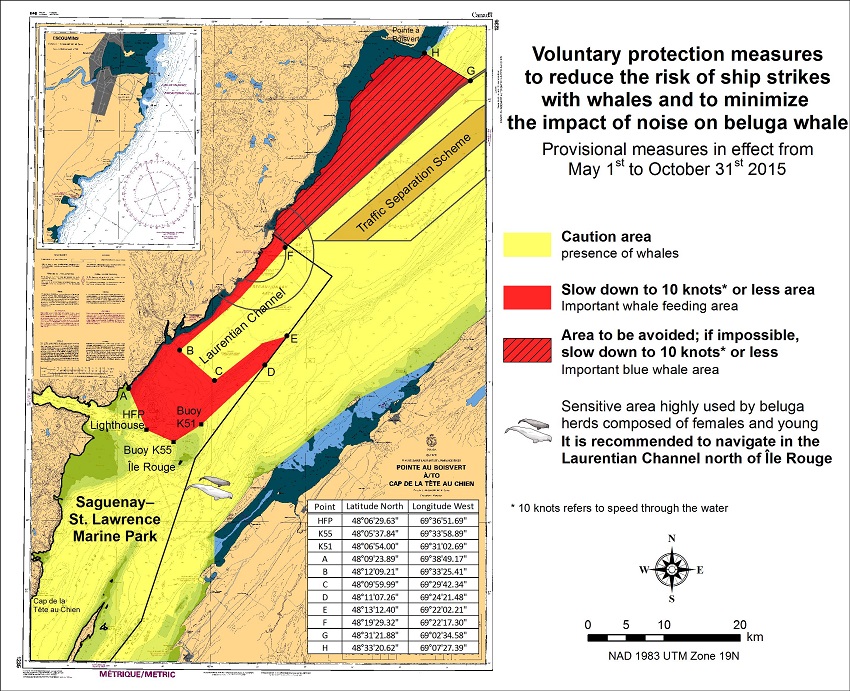
SAGUENAY-ST. LAWRENCE MARINE PARK AND SURROUNDING WATERS - WHALE PROTECTION.
The waters in and around the Saguenay-St. Lawrence Marine Park are well known for their resident threatened beluga population and the wide diversity of whales that migrate there to feed, particularly between April and November.
REGULATORY PROTECTION MEASURES
All whale species that are found in the St. Lawrence are protected under the Marine Mammal Regulations, pursuant to the Fisheries Act. Within the boundaries of the Marine Park, specific measures are set out in the Marine Activities in the Saguenay–St. Lawrence Marine Park Regulations, pursuant to the Act Establishing the Saguenay-St. Lawrence Marine Park. Any collision with a marine mammal within the Marine Park must immediately be reported to a park warden at 1-866-508-9888. For collisions that occur outside the Marine Park or for any situation involving a marine mammal that is dead or in trouble, contact the emergency network at 1-877-722-5346 or on channel 16.
For more information on the Saguenay-St. Lawrence Marine Park, see section 5C of the Annual Edition of the Notices to Mariners – April 2015 to March 2016.
VOLUNTARY PROTECTION MEASURES
Provisional measures in effect from May 1st to October 31st, 2015. See map below.
These measures apply to merchant vessels and cruise ships between Pointe à Boisvert and Cap de la Tête au Chien to prevent collisions with whales. These measures should only be taken when they will not jeopardize navigational safety.
Caution area (yellow area) : To reduce the risk of collisions with whales that can be present anywhere in this area, heightened vigilance of navigators is critical. Posting a lookout is recommended in order to increase the chances of seeing the whales and thus taking necessary measures to avoid them. If bypassing the whales is not possible, slow down and wait for the animals to move away to a distance greater than 400 meters (0.215 nautical miles) before resuming original speed. It is more difficult to see the animals at night therefore increased caution is recommended.
Slow down to 10 knots or less area (red area) : To reduce the risk of collisions with whales in this feeding area, it is recommended that vessels slow down to a maximum speed through the water of 10 knots and post a lookout. It is further recommended to remain in the Laurentian Channel to the north of Île Red to minimize the impact of noise in a sensitive area south of this island, which is highly frequented by herds of beluga whales composed of females and young.
Area to be avoided (hatched red area) : To reduce noise and the risk of collisions with whales, vessels should avoid transiting through this area which is highly frequented by blue whales, an endangered species. If the area cannot be avoided, slow down to a speed through the water of 10 knots or less.
TRANSPORT CANADA - RESTRICTED SPEED AREA - ST. CLAIR AND DETROIT RIVER.
Since November 14, 2012 the restricted speed area currently in place as per the St. Clair and Detroit River Navigation Safety Regulation between the Detroit River light and Peche Island light is reduced in size by relocating the southern point of the restricted speed area from its current location at the Detroit River light to a new location at Bar Point light D33. (This notice refers to the previous one published in November 2012 with number *1103)
CANADIAN COAST GUARD PUBLICATION - RADIO AIDS TO MARINE NAVIGATION (ATLANTIC, ST. LAWRENCE, GREAT LAKES, LAKE WINNIPEG AND EASTERN ARCTIC) PUBLICATION - 2013 - The Commercial Public Correspondence Service.
Part I - Page 1 of 10
ADVANCE NOTICES
The Commercial Public Correspondence Service
Effective January 1, 2014, the following changes to the Canadian Coast Guard commercial public correspondence service, provided through select Marine Communications and Traffic Services centres, will be in effect: All long distance ship-shore calls will be administered through the regular telephone service provider as acollect call. Individuals intending to placeshore-ship calls will be required to direct-dial the appropriate MCTS centre. MCTS centres providing a commercial public correspondence service are identified in RAMN, Part 2.
*701 CANADIAN HYDROGRAPHIC SERVICE - NAUTICAL CHARTS.
| CHARTS | MAIN TITLE | SCALE | PUBLISHED | CAT# | PRICE |
| New Editions | |||||
| 3795 | Langley Passage, Estevan Group | 1:12000 | 02-JUN-2015 | 2 | 20.00 |
| 7777 | Coronation Gulf Western Portion/Partie Ouest | 1:150000 | 30-JUN-2015 | 4 | 20.00 |
*702 CANADIAN HYDROGRAPHIC SERVICE - ELECTRONIC NAVIGATIONAL CHART
| NEW PRODUCTS | |
| S-57 ENC NUMBER | CHART TITLE |
| CA479242 | Baie du Renard - Île d'Anticosti |
*703 TRANSPORT CANADA – SHIP SAFETY BULLETIN (PUBLISHED AS OF JUNE 30, 2015).
Ship Safety Bulletins (TP 3231) – 2015
Ship Safety Bulletins address safety-related matters pertaining to vessels. Bulletins are available from
Transport Canada’s Marine Safety Directorate free of charge and are issued on an "as needed" basis.
A complete list of Ship Safety Bulletins is available on Transport Canada’s Web site at:
http://www.tc.gc.ca/eng/marinesafety/bulletins-menu.htm
If you do not have access to our Web site and wish to be included in the Ship Safety Bulletins mailing list, please send your request to the Marine Safety location provided below. We ask your cooperation in distributing copies of this listing to your colleagues, to ship owners and/or maritime companies to let them know of the existence of these Bulletins.
If this is the first time you are receiving the Bulletin, your name is probably not on Transport Canada’s mailing list. Should you wish to be included, please send your request to the Marine Safety location provided below.
How to stay up-to-date on newly published bulletins.
To receive Ship Safety Bulletins electronically, select the following Internet address and follow the instructions
on how to sign up for e-Bulletin or RSS feed services. E-Bulletin sends a notice to your e-mail address inbox,
whereas RSS feed sends a notice to your Internet browser when a new SSB becomes available on our Internet at
http://www.tc.gc.ca/eng/marinesafety/bulletins-menu.htm.
As of June 30, 2015, the following Ship Safety Bulletins have been issued:
| Bulletin No. | Bulletin Title | Date |
| 01/2015 | Fumigation on Board Vessels | 2015-01-05 |
| 02/2015 | Why you must document how to install, secure and seal movable bulkheads to ensure their grain tightness | 2015-01-24 |
| 03/2015 | Sheltered waters voyages (amendment 2015-05-29) | 2015-04-01 |
| 04/2015 | Regulations for Vessel Air Emissions: Fuel Oil Change-Over Operations | 2015-04-30 |
| 05/2015 | Regulations for Vessel Air Emissions: Criteria of an “Identical Engine” | 2015-05-01 |
| 06/2015 | Safety of Dead Ship Towing Operations | 2015-05-13 |
| 07/2015 | Board of Steamship Inspection Renewal Project: Phase 2 | 2015-06-17 |
Transport Publications (TPs) New and/or Updated – 2015
| Publication No. | Title | Date |
| TP 8911 | Engineering Officer Education and Training Program Updated | 2015 |
| TP 14707 | Places of Refuge Contingency Plan Atlantic Region Updated | 2014 |
| TP 15287 | TERMPOL Review Process Report on the Trans Mountain Expansion Project New | 2014 |
Copies of these publications may be obtained from:
Transports Canada
Marine Safety Directorate (AMSBA)
Place de Ville, Tower “C”
330 Sparks Street, 9th floor
Ottawa, Ontario, K1A 0N5
Website: Ship Safety Bulletins: :
http://www.tc.gc.ca/marinesafety/bulletins-menu.htm
Transport Publications::
http://www.tc.gc.ca/eng/marinesafety/tp-menu-515.htm
If you have questions, or require hardcopies of Ship Safety Bulletins or Transport Publications, contact Transport Canada Marine Safety Directorate by:
Email :
marinesafety-securitemaritime@tc.gc.ca
Phone : 613-991-3135
Toll Free (Marine) : 1-866-995-9737
Teletypewriter (TTY) :1-888-675-6863
FAx : 613-990-1879
*704 TRANSPORT CANADA - SHIP SAFETY BULLETIN.
This is to notify you that a new Ship Safety Bulletin has recently been posted to the Transport Canada website at
www.tc.gc.ca/bsn-ssb/.
To go online to view or download the bulletin, please click on the links below:
Subject: Board of Steamship Inspection Renewal Project: Phase 2
Issue: SSB No.: 07/2015
Date: 2015-06-17
Link:
http://www.tc.gc.ca/eng/marinesafety/bulletins-2015-07-eng.htm
Sign yourself up for e-Bulletin to
receive an e-mail notice each time a new Ship Safety Bulletin is published on our Website.
Contact us at : marinesafety-securitemaritime@tc.gc.caor 1-855-859-3123 (Toll free)
*705 CANADIAN COAST GUARD - LIST OF CHARTS AND REFERENCE CHARTS (SECTION I) AFFECTED BY TEMPORARY AND PRELIMINARY NOTICES
IN EFFECT JUNE 26, 2015
(REVISED AND PROMULGATED QUARTERLY)
|
2017 |
909(P)/14 |
|
3490 |
1112(P)/14 213(P)/15 |
|
3538 |
712(P)/15 |
|
3546 |
714(P)/14 1113(P)/14 |
|
3668 |
1213(P)/14 |
|
4010 |
605(P)/14 709(P)/15 |
|
4201 |
509(P) /13 |
|
4236 |
609(P)/15 610(P)/15 |
|
4241 |
810(P)/14 |
|
4244 |
1006(T)/14 |
|
4279 |
1210(P)/13 |
|
4340 |
418(P)/14 |
|
4374 |
310(P)/15 311(P)/15 508(P)/15 |
|
4375 |
411(P)/15 |
|
4377 |
405(P)/13 |
|
4385 |
202(P)/15 |
|
4386 |
1108(P)/13 |
|
4396 |
507(P)/14 705(P)/14 706(P)/14 709(P)/14 |
|
4406 |
612(P)/15 |
|
4422 |
1005(P)/14 1007(P)/14 |
|
4512 |
1205(P)/13 |
|
4596 |
1209(T)/13 1003(P)/09 |
|
4830 |
1104(T) /13; |
|
4851 |
511(P)/15 |
|
4909 |
613(P)/12 810(P)/12 |
|
4911 |
510(P)/15 811(P)/12 |
|
4912 |
509(P)/15 611(P)/15 |
|
5051 |
1208(T) /13; |
|
6267 |
1114(P)/14 |
|
US14832 |
712(T)/14 |
|
US14884 |
715(T)/13 |
|
US14853 |
1211(T)/14 |
*706 ANNUAL EDITON NOTICES TO MARINERS 1 TO 46. UPDATE TO SECTION 7B.
TP 15163 (The Joint Industry-Government Guidelines for the Control of Oil Tankers and Bulk Chemical Carriers in Ice Control Zones of Eastern Canada) has been updated with Ice operation centre information and few typographical corrections.
*707 PRINCE EDWARD-GULF – UNLIT BUOY TO BE DISCONTINUED.
The Canadian Coast Guard proposes to permanently discontinue the following Aid to navigation:
Conway Inlet buoy JS40, LL 6072.59 (46° 39’ 25.4’’N 063° 53’ 47.4’’W).
(G2015-050)
*708 HILLSBOROUGH BAY – RANGE DISCOUNTINUED.
Reference: Notice 109(P)/2014 LL 979 and 980 is now cancelled. (Chart 4466)
(G2015-045, 046)
*709(P) BAY OF FUNDY / BAIE DE FUNDY (INNER PORTION / PARTIE INTÉRIEURE) – AID TO BE DISCONTINUED.
Reference Chart: 4010
The Canadian Coast Guard proposes to permanently discontinue the following Aid to navigation:
Port Lorne light LL 197 (44° 56' 53.3"N 065° 15' 53.8"W)
Comments on this action are solicited from mariners and other interested parties.
Comments should be directed to the following within three months from the date of this notice:
Regional Superintendent, Claire MacLaren
Aids to Navigation & Waterways,
Canadian Coast Guard,
PO Box 5667,
St. John’s, NL, A1C 5X1
Telephone: 709-772-5195,
Email: Claire.maclaren@dfo-mpo.gc.ca
Any objections raised must state the facts on which they are based and should include supporting information on safety, commerce and public benefit.
(F2015-023)
*710(P) CANADIAN COAST GUARD PUBLICATION - AMENDMENT TO THE RADIO AIDS TO MARINE NAVIGATION (ATLANTIC, ST. LAWRENCE, GREAT LAKES, LAKE WINNIPEG AND ARCTIC) PUBLICATION – 2015
Part I – Page 1 of 13
ADVANCE NOTICES
2) ADD
In accordance with the International Maritime Organization’s standards for the International NAVTEX Service,
the Canadian Coast Guard will discontinue the NAVTEX broadcasts provided by Labrador Marine Communications
and Traffic Services, Ident X, scheduled daily at 0910UTC and 2110UTC, effective August 10, 2015.
Comments on this action are solicited from mariners and other interested parties until August 2, 2015, and
should be directed to:
Superintendent, Marine Communications and Traffic Services
Canadian Coast Guard
Dartmouth, NS
PO Box 1000
B2Y 3Z8
Telephone: 902-426-3797
Email: Dan.Nickle@dfo-mpo.gc.ca
CHART CORRECTIONS
| 1230 - Mont-Louis - New Edition - 19-FEB-2010 - NAD 1983 | |||
| 03-JUL-2015 | LNM/D. 05-JUN-2015 | ||
| Delete | depth of 1 metre 9 decimetres (See Chart No. 1, I10) This notice affects Electronic Navigational Chart: CA479057 |
49°14′01.4″N 065°43′28.3″W | |
| DFO(6409085-01) | |||
| Add | depth of 0 metres 4 decimetres (See Chart No. 1, I10) This notice affects Electronic Navigational Chart: CA479057 |
49°14′01.7″N 065°43′27.2″W | |
| DFO(6409085-02) | |||
| Delete | depth of 2 metres 7 decimetres (See Chart No. 1, I10) This notice affects Electronic Navigational Chart: CA479057 |
49°14′05.1″N 065°43′25.6″W | |
| DFO(6409085-03) | |||
| Add | depth of 1 metre 6 decimetres (See Chart No. 1, I10) This notice affects Electronic Navigational Chart: CA479057 |
49°14′04.9″N 065°43′24.9″W | |
| DFO(6409085-04) | |||
| Add | depth of 4 metres 9 decimetres (See Chart No. 1, I10) This notice affects Electronic Navigational Chart: CA479057 |
49°14′05.9″N 065°43′34.3″W | |
| DFO(6409085-05) | |||
| Delete | depth of 4 metres 6 decimetres (See Chart No. 1, I10) This notice affects Electronic Navigational Chart: CA479057 |
49°14′03.4″N 065°43′34.0″W | |
| DFO(6409085-06) | |||
| Add | depth of 4 metres 1 decimetre (See Chart No. 1, I10) This notice affects Electronic Navigational Chart: CA479057 |
49°14′03.6″N 065°43′35.1″W | |
| DFO(6409085-07) | |||
| Delete | depth of 4 metres 2 decimetres (See Chart No. 1, I10) This notice affects Electronic Navigational Chart: CA479057 |
49°14′01.1″N 065°43′42.1″W | |
| DFO(6409085-08) | |||
| Add | depth of 4 metres 1 decimetre (See Chart No. 1, I10) This notice affects Electronic Navigational Chart: CA479057 |
49°14′02.2″N 065°43′43.0″W | |
| DFO(6409085-09) | |||
| Delete | depth of 2 metres 8 decimetres (See Chart No. 1, I10) This notice affects Electronic Navigational Chart: CA479057 |
49°13′56.7″N 065°43′45.5″W | |
| DFO(6409085-10) | |||
| Add | depth of 2 metres 3 decimetres (See Chart No. 1, I10) This notice affects Electronic Navigational Chart: CA479057 |
49°13′56.9″N 065°43′45.3″W | |
| DFO(6409085-11) | |||
| Delete | depth of 4 metres 5 decimetres (See Chart No. 1, I10) This notice affects Electronic Navigational Chart: CA479057 |
49°13′59.2″N 065°43′54.1″W | |
| DFO(6409085-12) | |||
| Add | depth of 4 metres 0 decimetre (See Chart No. 1, I10) This notice affects Electronic Navigational Chart: CA479057 |
49°13′59.8″N 065°43′52.8″W | |
| DFO(6409085-13) | |||
| Add | depth of 2 metres 6 decimetres (See Chart No. 1, I10) This notice affects Electronic Navigational Chart: CA479057 |
49°13′57.3″N 065°43′58.8″W | |
| DFO(6409085-14) | |||
| Delete | depth of 6 metres 7 decimetres (See Chart No. 1, I10) This notice affects Electronic Navigational Chart: CA479057 |
49°14′12.2″N 065°43′31.7″W | |
| DFO(6409085-15) | |||
| Add | depth of 5 metres 5 decimetres (See Chart No. 1, I10) This notice affects Electronic Navigational Chart: CA479057 |
49°14′12.2″N 065°43′30.9″W | |
| DFO(6409085-16) | |||
| 1311 - Sorel-Tracy à/to Varennes - New Edition - 19-SEP-2013 - NAD 1983 | |||
| 31-JUL-2015 | LNM/D. 22-MAY-2015 | ||
| Delete | Bn Or beacon (See Chart No. 1, Q81) This notice affects Electronic Navigational Chart: CA479155 |
45°43′57.4″N 073°24′47.4″W | |
| (Q2015057) DFO(6409126-01) | |||
| 1312 - Lac Saint-Pierre - New Edition - 24-MAY-2013 - NAD 1983 | |||
| 24-JUL-2015 | LNM/D. 12-JUN-2015 | ||
| Delete | Bn Or beacon (See Chart No. 1, Q81) This notice affects Electronic Navigational Chart: CA479129 |
46°17′16.0″N 072°38′17.7″W | |
| (Q2015056) DFO(6409125-01) | |||
| 1313 - Batiscan au/to Lac Saint-Pierre - New Edition - 07-JUN-2013 - NAD 1983 | |||
| 24-JUL-2015 | LNM/D. 12-JUN-2015 | ||
| Delete | Bn Or beacon (See Chart No. 1, Q81) This notice affects Electronic Navigational Chart: CA479129 |
46°17′16.0″N 072°38′17.7″W | |
| (Q2015056) DFO(6409125-01) | |||
| 1314 - Portneuf - New Edition - 21-JUN-2013 - NAD 1983 | |||
| 03-JUL-2015 | LNM/D. 29-MAY-2015 | ||
| Affix | patch Downlaod patch - http://www.chs-shc.gc.ca/patches/pa1314-20150601.pdf This notice affects Electronic Navigational Chart: CA579019 |
46°40′54.9″N 071°52′36.9″W | |
| DFO(6409029-01) | |||
| 1316 - Port de Québec - New Edition - 02-DEC-2011 - NAD 1983 | |||
| 03-JUL-2015 | LNM/D. 09-JAN-2015 | ||
| Amend | 16,7m (2010) to read 16,4m (2014) (See Chart No. 1, I22) |
46°47′00.3″N 071°12′29.4″W | |
| DFO(6409104-02) | |||
| Add | leading light (Priv)2 F with clearing line bearing 211° (See Chart No. 1, P21) This notice affects Electronic Navigational Chart: CA579003 |
46°46′52.6″N 071°12′30.6″W | |
| (Q2015060-Q2015061) LL(12696-12697) DFO(6409133-01) | |||
| Add | leading light 2F R(Priv) with clearing line bearing 211° (See Chart No. 1, P21) This notice affects Electronic Navigational Chart: CA579003 |
46°46′52.2″N 071°12′29.3″W | |
| (Q2015062-Q2015063) LL(12698-12699) DFO(6409135-01) | |||
| 1431 - Canal de Beauharnois - New Edition - 26-DEC-2014 - NAD 1983 | |||
| 31-JUL-2015 | |||
| Affix | patch Download patch - http://www.chs-shc.gc.ca/patches/pa1431_20150731.pdf |
45°19′40.0″N 074°06′40.0″W | |
| DFO(6604110-01) | |||
| 1432 - Lac Saint-François/Lake St. Francis B-C - New Edition - 26-DEC-2014 - World Geodetic System 1984 | |||
| 31-JUL-2015 | |||
| Affix | patch Download patch - http://www.chs-shc.gc.ca/patches/pa1432_20150731.pdf |
45°04′00.0″N 074°36′00.0″W | |
| DFO(6604111-01) | |||
| 2077 - Lake Ontario/Lac Ontario (Western Portion/Partie Ouest) - New Edition - 23-APR-1999 - NAD 1983 | |||
| 17-JUL-2015 | LNM/D. 19-SEP-2014 | ||
| Add | underwater rock of unknown depth, dangerous to surface navigation, Rep (2015) (See Chart No. 1, K13, I3.2) This notice affects Electronic Navigational Chart: CA373091 |
43°11′44.5″N 079°23′34.5″W | |
| DFO(6604109-01) | |||
| 2110 - Long Point Bay - New Edition - 29-MAY-1998 - NAD 1983 | |||
| 31-JUL-2015 | LNM/D. 24-OCT-2014 | ||
| Delete | depth of 5.2 metres (See Chart No. 1, I10) |
42°45′57.2″N 080°11′45.4″W | |
| DFO(6604113-01) | |||
| Add | dangerous underwater rock with depth of 2.6 metres, Rep (2015) (See Chart No. 1, K14.1/K14.2) This notice affects Electronic Navigational Chart: CA273094, CA373093, CA473305 |
42°45′55.2″N 080°11′45.4″W | |
| DFO(6604113-02) | |||
| Delete | depth of 3.7 metres (See Chart No. 1, I10) |
42°46′25.4″N 080°11′55.5″W | |
| DFO(6604113-03) | |||
| Add | dangerous underwater rock with depth of 2.2 metres, Rep (2015) (See Chart No. 1, K14.1/K14.2) This notice affects Electronic Navigational Chart: CA273094, CA373093, CA473305 |
42°46′27.4″N 080°11′55.5″W | |
| DFO(6604113-04) | |||
| 2120 - Niagara River to/à Long Point - New Edition - 15-APR-2005 - NAD 1983 | |||
| 31-JUL-2015 | LNM/D. 19-JUN-2015 | ||
| Add | dangerous underwater rock with depth of 2.6 metres, Rep (2015) (See Chart No. 1, K14.1/K14.2) This notice affects Electronic Navigational Chart: CA273094, CA373093, CA473305 |
42°45′55.2″N 080°11′45.4″W | |
| DFO(6604113-02) | |||
| 4000 - Gulf of Maine to/à Baffin Bay / Baie de Baffin - New Edition - 25-JUL-2003 - NAD 1983 | |||
| 17-JUL-2015 | LNM/D. 19-JUN-2015 | ||
| Reposition | lighted offshore platform and legend GSF Grand Banks (See Chart No. 1, L2 and P2) This notice affects Electronic Navigational Chart: CA176030 |
from 46°44′38.0″N 047°00′37.0″W to 46°44′39.0″N 048°00′38.0″W |
|
| DFO(6307163-01) | |||
| 4001 - Gulf of Maine to Strait of Belle Isle /au Detroit de Belle Isle - New Edition - 01-DEC-1995 - NAD 1983 | |||
| 17-JUL-2015 | LNM/D. 03-JUL-2015 | ||
| Reposition | lighted offshore platform and legend GSF Grand Banks (See Chart No. 1, L2 and P2) This notice affects Electronic Navigational Chart: CA176030 |
from 46°44′38.0″N 047°00′37.0″W to 46°44′39.0″N 048°00′38.0″W |
|
| DFO(6307163-01) | |||
| 03-JUL-2015 | LNM/D. 19-JUN-2015 | ||
| Add | private yellow ODAS/SADO lighted pillar Fl Y, Priv, marked PMUI (See Chart No. 1, Q58) |
40°21′55.5″N 070°46′59.5″W | |
| DFO(6307161-01) | |||
| 4003 - Cape Breton to/à Cape Cod - New Edition - 21-MAR-2003 - NAD 1983 | |||
| 03-JUL-2015 | LNM/D. 27-FEB-2015 | ||
| Add | private yellow ODAS/SADO lighted pillar Fl Y, Priv, marked PMUI (See Chart No. 1, Q58) |
40°21′55.5″N 070°46′59.5″W | |
| DFO(6307161-01) | |||
| Reposition | yellow ODAS/SADO lighted super-buoy Fl(4) Y, marked 44011 (See Chart No. 1, Q58) This notice affects Electronic Navigational Chart: CA276367 |
from 41°06′41.0″N 066°34′47.0″W to 41°06′00.0″N 066°37′12.0″W |
|
| DFO(6307161-02) | |||
| Reposition | yellow ODAS/SADO lighted super-buoy Fl (4) Y, marked 44018 (See Chart No. 1, Q58) |
from 42°07′56.0″N 069°37′42.0″W to 42°08′15.0″N 069°42′46.0″W |
|
| DFO(6307161-03) | |||
| 4006 - Newfoundland and Labrador/Terre-Neuve-et-Labrador to Bermuda / aux Bermudes New Edition - 08-AUG-2003 - NAD 1983 | |||
| 03-JUL-2015 | LNM/D. 19-JUN-2015 | ||
| Add | private yellow ODAS/SADO lighted pillar Fl Y, Priv, marked PMUI (See Chart No. 1, Q58) |
40°21′55.5″N 070°46′59.5″W | |
| DFO(6307161-01) | |||
| 4012 - Yarmouth to/à Halifax - New Edition - 14-FEB-2003 - NAD 1983 | |||
| 31-JUL-2015 | LNM/D. 05-JUN-2015 | ||
| Amend | FogSig (Occas) to read FogSig (See Chart No. 1, R20) This notice affects Electronic Navigational Chart: CA276800, CA376047 |
43°27′03.8″N 065°28′09.5″W | |
| (F2015022) LL(336) DFO(6307210-01) | |||
| 4049 - Grand Bank, Northern Portion Grand Banc, Partie Nord to/à Flemish Pass/Passe Flamande - New Edition - 19-MAY-1995 - NAD 1983 | |||
| 17-JUL-2015 | LNM/D. 24-APR-2015 | ||
| Delete | lighted offshore platform Mo(U) 15M with FogSig30s and legend GSF Grand Banks (See Chart No. 1, L2, P2 et R20) This notice affects Electronic Navigational Chart: CA276101 |
46°44′38.0″N 047°00′37.0″W | |
| DFO(6307163-02) | |||
| Delete | safety zone with radius of 500 metres and legend
See/Voir Note PRODUCTION PLATFORMS PLATES-FORMES DE PRODUCTION
(See Chart No. 1, L3) This notice affects Electronic Navigational Chart: CA276101 |
46°44′48.0″N 047°00′37.0″W | |
| DFO(6307163-03) | |||
| Add | lighted offshore platform Mo(U) 15M with FogSig30s and legend GSF Grand Bank (See Chart No. 1, L2, P2 et R20) This notice affects Electronic Navigational Chart: CA276101 |
46°44′39.0″N 048°00′38.0″W | |
| DFO(6307163-04) | |||
| 4116 - Approaches to/Approches à Saint John - New Edition - 31-AUG-2007 - NAD 1983 | |||
| 24-JUL-2015 | LNM/D. 22-MAY-2015 | ||
| Add | anchor berth B1 (See Chart No. 1, N11.1) This notice affects Electronic Navigational Chart: CA376011, CA576005 |
45°11′30.6″N 066°05′58.8″W | |
| DFO(6307133-01) | |||
| Add | anchor berth B2 (See Chart No. 1, N11.1) This notice affects Electronic Navigational Chart: CA376011 |
45°10′39.6″N 066°07′17.4″W | |
| DFO(6307133-02) | |||
| Add | anchor berth B3 (See Chart No. 1, N11.1) This notice affects Electronic Navigational Chart: CA376011 |
45°10′16.8″N 066°05′36.0″W | |
| DFO(6307133-03) | |||
| Add | anchor berth B4 (See Chart No. 1, N11.1) This notice affects Electronic Navigational Chart: CA376011 |
45°09′34.8″N 066°08′52.2″W | |
| DFO(6307133-04) | |||
| Add | anchor berth B5 (See Chart No. 1, N11.1) This notice affects Electronic Navigational Chart: CA376011 |
45°09′31.8″N 066°06′55.2″W | |
| DFO(6307133-05) | |||
| Add | anchor berth B6 (See Chart No. 1, N11.1) This notice affects Electronic Navigational Chart: CA376011 |
45°08′15.0″N 066°10′32.4″W | |
| DFO(6307133-06) | |||
| Add | anchor berth B7 (See Chart No. 1, N11.1) This notice affects Electronic Navigational Chart: CA376011 |
45°08′15.0″N 066°08′35.4″W | |
| DFO(6307133-07) | |||
| Add | anchor berth B8 (See Chart No. 1, N11.1) This notice affects Electronic Navigational Chart: CA376011 |
45°08′15.0″N 066°06′49.2″W | |
| DFO(6307133-08) | |||
| Add | anchor berth D1 (See Chart No. 1, N11.1) This notice affects Electronic Navigational Chart: CA376011 |
45°10′24.0″N 066°01′57.6″W | |
| DFO(6307133-09) | |||
| Add | anchor berth D2 (See Chart No. 1, N11.1) This notice affects Electronic Navigational Chart: CA376011 |
45°09′16.8″N 066°02′52.2″W | |
| DFO(6307133-10) | |||
| Add | anchor berth D3 (See Chart No. 1, N11.1) This notice affects Electronic Navigational Chart: CA376011 |
45°09′16.8″N 066°01′02.4″W | |
| DFO(6307133-11) | |||
| Add | anchor berth D4 (See Chart No. 1, N11.1) This notice affects Electronic Navigational Chart: CA376011 |
45°08′13.8″N 066°03′42.6″W | |
| DFO(6307133-12) | |||
| Add | anchor berth D5 (See Chart No. 1, N11.1) This notice affects Electronic Navigational Chart: CA376011 |
45°08′13.8″N 066°01′57.6″W | |
| DFO(6307133-13) | |||
| Add | anchor berth D6 (See Chart No. 1, N11.1) This notice affects Electronic Navigational Chart: CA376011 |
45°08′13.8″N 066°00′09.6″W | |
| DFO(6307133-14) | |||
| 4117 - Saint John Harbour and Approaches / et les approches - New Edition - 29-MAY-2009 - NAD 1983 | |||
| 24-JUL-2015 | LNM/D. 05-JUN-2015 | ||
| Add | anchor berth B1 (See Chart No. 1, N11.1) This notice affects Electronic Navigational Chart: CA376011, CA576005 |
45°11′30.6″N 066°05′58.8″W | |
| DFO(6307133-01) | |||
| 4230 - Little Hope Island to/à Cape St Marys - New Chart - 15-JUN-1990 - NAD 1983 | |||
| 31-JUL-2015 | LNM/D. 05-JUN-2015 | ||
| Amend | FogSig 20s (Occas) to read FogSig 20s (See Chart No. 1, R20) This notice affects Electronic Navigational Chart: CA276800, CA376047 |
43°27′00.0″N 065°28′15.4″W | |
| (F2015022) LL(336) DFO(6307210-01) | |||
| 4241 - Lockeport to/à Cape Sable - New Edition - 08-NOV-2002 - NAD 1983 | |||
| 31-JUL-2015 | LNM/D. 05-JUN-2015 | ||
| Amend | FogSig 20s (Occas) to read FogSig 20s (See Chart No. 1, R20) This notice affects Electronic Navigational Chart: CA276800, CA376047 |
43°26′58.7″N 065°28′14.4″W | |
| (F2015022) LL(336) DFO(6307210-01) | |||
| 4242 - Cape Sable Island to/aux Tusket Islands - New Edition - 28-AUG-1992 - NAD 1983 | |||
| 31-JUL-2015 | LNM/D. 05-JUN-2015 | ||
| Amend | FogSig 20s (Occas) to read FogSig 20s (See Chart No. 1, R20) This notice affects Electronic Navigational Chart: CA276800, CA376047 |
43°26′58.9″N 065°28′14.1″W | |
| (F2015022) LL(336) DFO(6307210-01) | |||
| 4255 - Georges Bank/Banc de Georges - Eastern Portion/Partie Est - New Chart - 27-JUL-1990 - NAD 1983 | |||
| 03-JUL-2015 | LNM/D. 16-MAY-2008 | ||
| Reposition | yellow ODAS/SADO lighted super-buoy Fl(4) Y, marked 44011 (See Chart No. 1, Q58) This notice affects Electronic Navigational Chart: CA276367 |
from 41°06′40.1″N 066°34′44.8″W to 41°06′00.0″N 066°37′12.0″W |
|
| DFO(6307161-02) | |||
| 4302 - Point Tupper to Ship Point - New Chart - 28-SEP-2012 - NAD 1983 | |||
| 17-JUL-2015 | LNM/D. 24-APR-2015 | ||
| Add | subsurface Ocean Data Acquisition system ODAS/SADO, depth unknown (See Chart No. 1, L25) This notice affects Electronic Navigational Chart: CA476678, CA576680 |
45°35′00.1″N 061°21′00.5″W | |
| DFO(6307162-01) | |||
| 4302 - Strait of Canso - New Chart - 28-SEP-2012 - NAD 1983 | |||
| 17-JUL-2015 | LNM/D. 24-APR-2015 | ||
| Add | subsurface Ocean Data Acquisition system ODAS/SADO, depth unknown (See Chart No. 1, L25) This notice affects Electronic Navigational Chart: CA476678, CA576680 |
45°35′00.1″N 061°21′00.5″W | |
| DFO(6307162-01) | |||
| Add | subsurface Ocean Data Acquisition system ODAS/SADO, depth unknown (See Chart No. 1, L25) This notice affects Electronic Navigational Chart: CA476678 |
45°32′00.3″N 61°16′58.1″W | |
| DFO(6307162-02) | |||
| Add | subsurface Ocean Data Acquisition system ODAS/SADO, depth unknown (See Chart No. 1, L25) This notice affects Electronic Navigational Chart: CA476678 |
45°32′00.3″N 061°14′00.5″W | |
| DFO(6307162-03) | |||
| 4307 - Canso Harbour to/au Strait of Canso - New Edition - 04-JAN-2008 - NAD 1983 | |||
| 17-JUL-2015 | LNM/D. 24-APR-2015 | ||
| Add | subsurface Ocean Data Acquisition system ODAS/SADO, depth unknown (See Chart No. 1, L25) This notice affects Electronic Navigational Chart: CA476678 |
45°32′00.3″N 061°16′58.1″W | |
| DFO(6307162-02) | |||
| Add | subsurface Ocean Data Acquisition system ODAS/SADO, depth unknown (See Chart No. 1, L25) This notice affects Electronic Navigational Chart: CA476678 |
45°32′00.3″N 061°14′00.5″W | |
| DFO(6307162-03) | |||
| Add | subsurface Ocean Data Acquisition system ODAS/SADO, depth unknown (See Chart No. 1, L25) This notice affects Electronic Navigational Chart: CA476277 |
45°28′33.5″N 061°09′57.4″W | |
| DFO(6307162-04) | |||
| Add | subsurface Ocean Data Acquisition system ODAS/SADO, depth unknown (See Chart No. 1, L25) This notice affects Electronic Navigational Chart: CA476277 |
45°25′00.3″N 061°06′00.3″W | |
| DFO(6307162-05) | |||
| 4308 - St. Peters Bay to/à Strait of Canso - New Edition - 21-MAR-2003 - NAD 1983 | |||
| 17-JUL-2015 | LNM/D. 26-JUN-2015 | ||
| Add | subsurface Ocean Data Acquisition system ODAS/SADO, depth unknown (See Chart No. 1, L25) This notice affects Electronic Navigational Chart: CA476678 |
45°32′00.3″N 061°16′58.1″W | |
| DFO(6307162-02) | |||
| Add | subsurface Ocean Data Acquisition system ODAS/SADO, depth unknown (See Chart No. 1, L25) This notice affects Electronic Navigational Chart: CA476678 |
45°32′00.3″N 061°14′00.5″W | |
| DFO(6307162-03) | |||
| Add | subsurface Ocean Data Acquisition system ODAS/SADO, depth unknown (See Chart No. 1, L25) This notice affects Electronic Navigational Chart: CA476277 |
45°28′33.5″N 061°09′57.4″W | |
| DFO(6307162-04) | |||
| 4320 - Egg Island to/à West ironbound Island - New Edition - 26-SEP-1997 - NAD 1983 | |||
| 31-JUL-2015 | LNM/D. 29-MAY-2015 | ||
| Delete | submarine cable (See Chart No. 1, L30.1) This notice affects Electronic Navigational Chart: CA476664 |
between 44°19′44.0″N 064°16′44.0″W and 44°18′51.8″N 064°10′13.4″W |
|
| DFO(6307178-01) | |||
| 4328 - Lunenburg Bay - New Edition - 10-JUL-1998 - NAD 1983 | |||
| 31-JUL-2015 | LNM/D. 06-FEB-2015 | ||
| Delete | submarine cable (See Chart No. 1, L30.1) This notice affects Electronic Navigational Chart: CA476664 |
between 44°19′44.1″N 064°16′44.2″W and 44°18′56.9″N 064°10′20.9″W |
|
| DFO(6307178-01) | |||
| 4335 - Strait of Canso and Approaches/et les approches - New Edition - 04-JAN-2008 - NAD 1983 | |||
| 17-JUL-2015 | LNM/D. 26-JUN-2015 | ||
| Add | subsurface Ocean Data Acquisition system ODAS/SADO depth unknown (See Chart No. 1, L25) This notice affects Electronic Navigational Chart: CA476678, CA576680 |
45°35′00.1″N 061°21′00.5″W | |
| DFO(6307162-01) | |||
| Add | subsurface Ocean Data Acquisition system ODAS/SADO depth unknown (See Chart No. 1, L25) This notice affects Electronic Navigational Chart: CA476678 |
45°32′00.3″N 061°16′58.1″W | |
| DFO(6307162-02) | |||
| Add | subsurface Ocean Data Acquisition system ODAS/SADO depth unknown (See Chart No. 1, L25) This notice affects Electronic Navigational Chart: CA476678 |
45°32′00.3″N 061°14′00.5″W | |
| DFO(6307162-03) | |||
| Add | subsurface Ocean Data Acquisition system ODAS/SADO depth unknown (See Chart No. 1, L25) This notice affects Electronic Navigational Chart: CA476277 |
45°28′33.5″N 061°09′57.4″W | |
| DFO(6307162-04) | |||
| Add | subsurface Ocean Data Acquisition system ODAS/SADO depth unknown (See Chart No. 1, L25) This notice affects Electronic Navigational Chart: CA476277 |
45°25′00.3″N 061°06′00.3″W | |
| DFO(6307162-05) | |||
| 4384 - Pearl Island to/à Cape La Have - New Edition - 10-JAN-2003 - NAD 1983 | |||
| 31-JUL-2015 | LNM/D. 06-FEB-2015 | ||
| Delete | submarine cable (See Chart No. 1, L30.1) This notice affects Electronic Navigational Chart: CA476664 |
between 44°19′44.0″N 064°16′44.0″W and 44°18′56.6″N 064°10′22.2″W |
|
| DFO(6307178-01) | |||
| 4403 - East Point to/à Cape Bear - New Edition - 04-APR-2003 - NAD 1983 | |||
| 10-JUL-2015 | LNM/D. 08-MAY-2015 | ||
| Reposition | green port hand lighted spar buoy Fl G, marked NH3 (See Chart No. 1, Qg) This notice affects Electronic Navigational Chart: CA376248 |
from 46°09′30.2″N 062°29′41.7″W to 46°09′31.1″N 062°29′34.5″W |
|
| (G2015041) LL(953.5) DFO(6307152-01) | |||
| 4405 - Pictou Island to/aux Tryon Shoals - New Edition - 21-FEB-2003 - NAD 1983 | |||
| 24-JUL-2015 | LNM/D. 17-JUL-2015 | ||
| Add | red starboard hand spar buoy, marked UE4 (See Chart No. 1, Qf) This notice affects Electronic Navigational Chart: CA376161 |
45°49′11.3″N 063°13′10.5″W | |
| DFO(6307209-02) | |||
| 17-JUL-2015 | LNM/D. 05-DEC-2014 | ||
| Delete | front range/leading light F (See Chart No. 1, P20.2) This notice affects Electronic Navigational Chart: CA376161, CA476179 |
46°03′16.6″N 062°57′19.5″W | |
| (G2015045) LL(979) DFO(6307156-01) | |||
| Delete | rear range/leading light F with leading line (See Chart No. 1, P20.2) This notice affects Electronic Navigational Chart: CA376161, CA476179 |
46°03′26.3″N 062°57′14.4″W | |
| (G2015046) LL(980.0) DFO(6307156-02) | |||
| 4422 - Cardigan Bay - New Edition - 26-DEC-2003 - NAD 1983 | |||
| 10-JUL-2015 | LNM/D. 08-MAY-2015 | ||
| Reposition | green port hand lighted spar buoy Fl G, marked NH3 (See Chart No. 1, Qg) This notice affects Electronic Navigational Chart: CA376248 |
from 46°09′30.2″N 062°29′41.7″W to 46°09′31.1″N 062°29′34.5″W |
|
| (G2015041) LL(953.5) DFO(6307152-01) | |||
| Delete | green port hand lighted spar buoy QG, marked NH5 (See Chart No. 1, Qg) |
46°09′32.2″N 062°30′27.3″W | |
| (G2015049) LL(953.6) DFO(6307152-03) | |||
| Add | green port hand spar buoy, marked NK1 (See Chart No. 1, Qg) |
46°09′29.6″N 062°30′28.2″W | |
| (G2015048) LL(5953.5) DFO(6307152-04) | |||
| Delete | green port hand can buoy, marked NH9 (See Chart No. 1, Qg) |
46°09′46.5″N 062°31′10.4″W | |
| (G2015053) LL(5953.7) DFO(6307152-05) | |||
| Add | green port hand lighted spar buoy QG, marked NH9 (See Chart No. 1, Qg) |
46°09′45.3″N 062°31′00.7″W | |
| (G2015054) LL(953.7) DFO(6307152-06) | |||
| 4466 - Hillsborough Bay - New Edition - 21-MAR-2003 - NAD 1983 | |||
| 17-JUL-2015 | LNM/D. 26-SEP-2014 | ||
| Delete | front range/leading light F 29ft (See Chart No. 1, P20.2) This notice affects Electronic Navigational Chart: CA376161, CA476179 |
46°03′16.6″N 062°57′19.5″W | |
| (G2015045) LL(979) DFO(6307156-01) | |||
| Delete | rear range/leading light F 46ft with leading line and bearings 018° - 198° (See Chart No. 1, P20.2) This notice affects Electronic Navigational Chart: CA376161, CA476179 |
46°03′26.3″N 062°57′14.4″W | |
| (G2015046) LL(980.0) DFO(6307156-02) | |||
| 4491 - Malpeque Bay - New Edition - 13-DEC-2002 - NAD 1983 | |||
| 24-JUL-2015 | LNM/D. 04-NOV-2011 | ||
| Reposition | green port hand lighted spar buoy QG, marked JU3 (See Chart No. 1, Qg) |
from 46°33′43.2″N 063°41′29.7″W to 46°33′46.3″N 063°41′37.6″W |
|
| (G2015057) LL(1069.5) DFO(6307172-01) | |||
| 4497 - Amet Sound - New Edition - 27-JUN-2003 - NAD 1983 | |||
| 24-JUL-2015 | LNM/D. 02-JUL-2010 | ||
| Delete | light FlR against red starboard hand spar buoy, marked UE4 (See Chart No. 1, Qf) |
45°49′11.3″N 063°13′10.5″W | |
| DFO(6307209-01) | |||
| 4644 - Bay D'Espoir and/et Hermitage Bay - New Edition - 25-JUN-1999 - NAD 1983 | |||
| 17-JUL-2015 | LNM/D. 27-MAR-2015 | ||
| Add | marine farm (See Chart No. 1, K48.2) This notice affects Electronic Navigational Chart: CA476479 |
47°43′36.2″N 056°09′56.6″W | |
| DFO(6307175-01) | |||
| 4846 - Motion Bay to/à Cape St Francis - New Edition - 15-DEC-1995 - NAD 1983 | |||
| 24-JUL-2015 | LNM/D. 26-SEP-2014 | ||
| Add | depth of 1 metre, 6 decimetres (See Chart No. 1, I10) This notice affects Electronic Navigational Chart: CA376015 |
47°42′01.9″N 052°42′16.9″W | |
| DFO(6307177-01) | |||
| 4849 - Bonavista Harbour - New Chart - 30-DEC-1988 - NAD 1983 | |||
| 24-JUL-2015 | LNM/D. 27-MAR-2015 | ||
| Affix | patch Download patch - http://www.chs-shc.gc.ca/patches/4849PA_20150617.pdf This notice affects Electronic Navigational Chart: CA576310 |
48°39′00.0″N 053°06′50.0″W | |
| DFO(6307176-01) | |||
| 4906 - West Point à/to Baie de Tracadie - New Chart - 18-MAR-1988 - NAD 1983 | |||
| 24-JUL-2015 | LNM/D. 15-MAY-2015 | ||
| Reposition | red starboard hand lighted spar buoy QR, marked TA2/2 (See Chart No. 1 Qf) This notice affects Electronic Navigational Chart: CA376062 |
from 47°19′00.5″N 064°55′18.6″W to 47°18′56.3″N 064°55′21.1″W |
|
| (G2015059) LL(1238.05) DFO(6307182-01) | |||
| 4913 - Caraquet Harbour, Baie de Shippegan and/et Miscou Harbour - New Chart - 07-AUG-1992 - NAD 1983 | |||
| 24-JUL-2015 | LNM/D. 17-JUL-2015 | ||
| Add | depth of 0 metres, 4 decimetres (See Chart No. 1, I10) This notice affects Electronic Navigational Chart: CA476275, CA576269 |
47°44′54.2″N 064°42′14.4″W | |
| DFO(6307170-01) | |||
| Delete | depth of 2 metres, 7 decimetres (See Chart No. 1, I10) This notice affects Electronic Navigational Chart: CA476275, CA576269 |
47°43′28.4″N 064°40′02.0″W | |
| DFO(6307170-05) | |||
| Add | depth of 1 metre, 3 decimetres (See Chart No. 1, I10) This notice affects Electronic Navigational Chart: CA476275, CA576269 |
47°43′29.9″N 064°40′00.3″W | |
| DFO(6307170-06) | |||
| 17-JUL-2015 | LNM/D. 24-APR-2015 | ||
| Amend | FlR to read QR against light (See Chart No. 1, P1) This notice affects Electronic Navigational Chart: CA476275, CA576263 |
47°47′49.0″N 064°55′31.3″W | |
| (G2015055) LL(1319) DFO(6307171-01) | |||
| 4920 - Bathurst Harbour - New Edition - 29-JUL-2005 - NAD 1983 | |||
| 24-JUL-2015 | LNM/D. 17-JUL-2015 | ||
| Add | depth of 2 metres, 7 decimetres (See Chart No. 1, I10) This notice affects Electronic Navigational Chart: CA576270 |
47°38′08.4″N 065°39′00.3″W | |
| DFO(6307170-07) | |||
| Add | depth of 1 metre, 9 decimetres (See Chart No. 1, I10) This notice affects Electronic Navigational Chart: CA576270 |
47°39′19.4″N 065°37′09.1″W | |
| DFO(6307170-08) | |||
| Add | depth of 1 metre, 5 decimetres (See Chart No. 1, I10) This notice affects Electronic Navigational Chart: CA576270 |
47°39′34.7″N 065°36′58.3″W | |
| DFO(6307170-09) | |||
| Add | depth of 0 metres, 7 decimetres (See Chart No. 1, I10) This notice affects Electronic Navigational Chart: CA576270 |
47°39′43.9″N 065°36′50.7″W | |
| DFO(6307170-10) | |||
| Add | depth of 2 metres, 6 decimetre (See Chart No. 1, I10) This notice affects Electronic Navigational Chart: CA576270 |
47°40′15.4″N 065°36′29.3″W | |
| DFO(6307170-11) | |||
| Delete | depth of 3 metres, 5 decimetres (See Chart No. 1, I10) This notice affects Electronic Navigational Chart: CA576270 |
47°40′14.8″N 065°36′28.1″W | |
| DFO(6307170-12) | |||
| 4920 - Caraquet - New Edition - 29-JUL-2005 - NAD 1983 | |||
| 17-JUL-2015 | LNM/D. 03-OCT-2014 | ||
| Amend | FlR to read QR against light (See Chart No. 1, P1) This notice affects Electronic Navigational Chart: CA476275, CA576263 |
47°47′49.0″N 064°55′31.3″W | |
| (G2015055) LL(1319) DFO(6307171-01) | |||
| 4920 - Quai / Wharf Belledune - New Edition - 29-JUL-2005 - NAD 1983 | |||
| 24-JUL-2015 | LNM/D. 17-JUL-2015 | ||
| Replace | depth of 10 metres, 8 decimetres with depth of 10 metres, 3 decimetres (See Chart No. 1, I10) This notice affects Electronic Navigational Chart: CA576268 |
47°54′39.2″N 065°50′42.9″W | |
| DFO(6307170-03) | |||
| 4920 - Quai / Wharf Petit-Rocher - New Edition - 29-JUL-2005 - NAD 1983 | |||
| 24-JUL-2015 | LNM/D. 17-JUL-2015 | ||
| Add | depth of 1 metre, 2 decimetres (See Chart No. 1, I10) This notice affects Electronic Navigational Chart: CA576267 |
47°47′01.3″N 065°42′18.3″W | |
| DFO(6307170-02) | |||
| Add | depth of 0 metres, 8 decimetres (See Chart No. 1, I10) This notice affects Electronic Navigational Chart: CA576267 |
47°46′57.2″N 065°42′27.4″W | |
| DFO(6307170-04) | |||
| Delete | depth of 1 metre, 3 decimetres (See Chart No. 1, I10) This notice affects Electronic Navigational Chart: CA576267 |
47°46′57.2″N 065°42′26.7″W | |
| DFO(6307170-13) | |||
| 4920 - Shippegan Harbour - New Edition - 29-JUL-2005 - NAD 1983 | |||
| 24-JUL-2015 | LNM/D. 17-JUL-2015 | ||
| Add | depth of 0 metres, 4 decimetres (See Chart No. 1, I10) This notice affects Electronic Navigational Chart: CA476275, CA576269 |
47°44′54.2″N 064°42′14.4″W | |
| DFO(6307170-01) | |||
| Delete | depth of 2 metres, 7 decimetres (See Chart No. 1, I10) This notice affects Electronic Navigational Chart: CA476275, CA576269 |
47°43′28.4″N 064°40′02.0″W | |
| DFO(6307170-05) | |||
| Add | depth of 1 metre, 3 decimetres (See Chart No. 1, I10) This notice affects Electronic Navigational Chart: CA476275, CA576269 |
47°43′29.9″N 064°40′00.3″W | |
| DFO(6307170-06) | |||
| 4921 - Mal-Bay - New Edition - 16-MAR-2012 - NAD 1983 | |||
| 24-JUL-2015 | LNM/D. 26-JUN-2015 | ||
| Delete | depth of 5 metres 6 decimetres (See Chart No. 1, I10) This notice affects Electronic Navigational Chart: CA579063 |
48°37′12.5″N 064°11′58.9″W | |
| DFO(6409148-01) | |||
| Add | depth of 4 metres 8 decimetres (See Chart No. 1, I10) This notice affects Electronic Navigational Chart: CA579063 |
48°37′12.7″N 064°11′58.9″W | |
| DFO(6409148-02) | |||
| Delete | depth of 6 metres 4 decimetres (See Chart No. 1, I10) This notice affects Electronic Navigational Chart: CA579063 |
48°37′13.8″N 064°11′59.9″W | |
| DFO(6409148-03) | |||
| Add | depth of 6 metres 0 decimetre (See Chart No. 1, I10) This notice affects Electronic Navigational Chart: CA579063 |
48°37′13.5″N 064°11′59.9″W | |
| DFO(6409148-04) | |||
| Add | depth of 5 metres 2 decimetres (See Chart No. 1, I10) This notice affects Electronic Navigational Chart: CA579063 |
48°37′14.3″N 064°12′09.3″W | |
| DFO(6409148-05) | |||
| Add | depth of 1 metre 3 decimetres (See Chart No. 1, I10) This notice affects Electronic Navigational Chart: CA579063 |
48°37′12.5″N 064°11′57.5″W | |
| DFO(6409148-06) | |||
| Add | depth of 2 metres 9 decimetres (See Chart No. 1, I10) This notice affects Electronic Navigational Chart: CA579063 |
48°37′15.7″N 064°11′57.9″W | |
| DFO(6409148-07) | |||
| 6355 - Mirage Point to/à Hardisty Island - Sheet/Feuille 1 - New Edition - 27-MAY-2005 - NAD 1983 | |||
| 03-JUL-2015 | LNM/D. 24-APR-2015 | ||
| Delete | depth of 17 feet (See Chart No. 1, I10) |
61°46′15.0″N 114°36′51.0″W | |
| DFO(6604107-01) | |||
| Add | obstruction, depth unknown, Rep (2015) (See Chart No. 1, K40, I3.2) |
61°46′14.0″N 114°36′53.0″W | |
| DFO(6604107-02) | |||
| Add | obstruction, depth unknown, Rep (2015) (See Chart No. 1, K40, I3.2) |
61°46′23.0″N 114°36′45.0″W | |
| DFO(6604107-03) | |||
| 6356 - Hardisty Island to/à North Head - Sheet/Feuille 1 - New Edition - 27-MAY-2005 - NAD 1983 | |||
| 03-JUL-2015 | LNM/D. 24-APR-2015 | ||
| Delete | depth of 17 feet (See Chart No. 1, I10) |
61°46′15.0″N 114°36′51.0″W | |
| DFO(6604107-01) | |||
| Add | obstruction, depth unknown, Rep (2015) (See Chart No. 1, K40, I3.2) |
61°46′14.0″N 114°36′53.0″W | |
| DFO(6604107-02) | |||
| Add | obstruction, depth unknown, Rep (2015) (See Chart No. 1, K40, I3.2) |
61°46′23.0″N 114°36′45.0″W | |
| DFO(6604107-03) | |||
| Add | obstruction, depth unknown, Rep (2015) (See Chart No. 1, K40, I3.2) |
61°42′29.0″N 114°52′26.0″W | |
| DFO(6604107-04) | |||
| Add | obstruction, depth unknown, Rep (2015) (See Chart No. 1, K40) |
61°42′42.0″N 114°51′34.0″W | |
| DFO(6604107-05) | |||
| 6370 - Great Slave Lake / Grand lac des Esclaves, Western Portion / Partie ouest - Sheet/Feuille 1 New Edition - 03-AUG-1990 - Astronomic Positioning | |||
| 03-JUL-2015 | LNM/D. 07-FEB-2014 | ||
| Delete | depth of 3.4 metres (See Chart No. 1, I10) |
61°46′15.0″N 114°36′00.0″W | |
| DFO(6604107-01) | |||
| Add | obstruction, depth unknown, Rep (2015) (See Chart No. 1, K40, I3.2) |
61°46′15.4″N 114°36′42.8″W | |
| DFO(6604107-02) | |||
| Add | obstruction, depth unknown, Rep (2015) (See Chart No. 1, K40, I3.2) |
61°42′23.4″N 114°52′15.8″W | |
| DFO(6604107-04) | |||
| Add | obstruction, depth unknown, Rep (2015) (See Chart No. 1, K40) |
61°42′43.4″N 114°51′23.8″W | |
| DFO(6604107-05) | |||
| 8005 - Georges Bank - New Edition - 20-JUN-2003 - NAD 1983 | |||
| 03-JUL-2015 | LNM/D. 02-DEC-2011 | ||
| Reposition | yellow ODAS/SADO lighted super-buoy Fl(4) Y, marked 44011 (See Chart No. 1, Q58) This notice affects Electronic Navigational Chart: CA276367 |
from 41°06′41.0″N 066°34′47.0″W to 41°06′00.0″N 066°37′12.0″W |
|
| DFO(6307161-02) | |||
| 8006 - Scotian Shelf/Plate-Forme Néo-Écossaise, Browns Bank to Emerald Bank/Banc de Brown au Banc D'Émeraude New Edition - 14-FEB-2003 - NAD 1983 | |||
| 31-JUL-2015 | LNM/D. 05-JUN-2015 | ||
| Amend | FogSig (Occas) to read FogSig (See Chart No. 1, R20) This notice affects Electronic Navigational Chart: CA276800, CA376047 |
43°26′58.7″N 065°28′14.4″W | |
| (F2015022) LL(336) DFO(6307210-01) | |||
| 8012 - Flemish Pass/Passe Flamande - New Edition - 11-OCT-2002 - NAD 1983 | |||
| 17-JUL-2015 | LNM/D. 29-MAY-2015 | ||
| Delete | lighted offshore platform Mo(U) 15M with FogSig30s and legend GSF Grand Banks (See Chart No. 1, L2, P2 and R20) This notice affects Electronic Navigational Chart: CA276101 |
46°44′38.0″N 047°00′37.0″W | |
| DFO(6307163-02) | |||
| Delete | safety zone with radius of 500 metres and legend See/Voir Note PRODUCTION PLATFORMS PLATES-FORMES DE PRODUCTION (See Chart No. 1, L3) This notice affects Electronic Navigational Chart: CA276101 |
46°44′48.0″N 047°00′37.0″W | |
| DFO(6307163-03) | |||
| Add | lighted offshore platform Mo(U) 15M with FogSig30s and legend GSF Grand Banks (See Chart No. 1, L2, P2 and R20) This notice affects Electronic Navigational Chart: CA276101 |
46°44′39.0″N 048°00′38.0″W | |
| DFO(6307163-04) | |||
CORRECTIONS TO RADIO AIDS TO MARINE NAVIGATION
*713 RADIO AIDS TO MARINE NAVIGATION 2015, (ATLANTIC, ST. LAWRENCE, GREAT LAKES, LAKE WINNIPEG AND ARCTIC)
PART 1 - Page 9
AMEND the following rows:
Table 1-4- Telephone / Facsimile / Telex Directory
| Service | Telephone Number |
Facsimile Number |
Telex Number |
Answer Back Code |
MMSI |
| MCTS (call sign) | |||||
| Rivière-au-Renard, QC (VCG) Service available in English and in French. | 418-269-5686 | 418-269-5514 | 003160025 | ||
| ECAREG CANADA | |||||
| Rivière-au-Renard, QC Service available in English and in French. | 418-269-3843 | 418-269-5514 | |||
TO READ
| Service | Telephone Number |
Facsimile Number |
Telex Number |
Answer Back Code |
MMSI |
| MCTS (call sign) | |||||
| ECAREG CANADA | |||||
| Les Escoumins, QC Service available in English and in French. | 418-233-2194 | 418-233-3299 | |||
PART 2 - Page 3
AMEND
Table 2-2 - MCTS Halifax / VCS - Broadcasts
| Time UTC |
Site | Frequency or Channel |
Contents |
| 01:40 | Lockeport Saint John |
Ch21B | Radiotelephony (English followed by French) • Technical marine forecasts synopsis, forecasts and wave height forecasts for marine areas 201, 202, 203, 204, 205, 206, 207 and 208. • U.S. weather forecasts for Coastal Waters – Eastport to Schoodic Point, Maine and Offshore Waters – Gulf of Maine to the Hague Line. • Notices to Shipping in areas Bay of Fundy, South and West Coast Nova Scotia. |
| Yarmouth Cape Blomidon |
Ch83B | ||
| 02:40 | Sambro | 2749J3E | Radiotelephony • Technical marine synopsis, forecasts and wave height forecasts for marine areas 203 to 214. • Notices to Shipping in South Coast Nova Scotia area. • Notices to Shipping revising the position of every reported offshore exploration and exploitation vessel. |
| Sambro Fox Island |
Ch21B | ||
| Ecum Secum |
Ch83B | ||
| 03:20 | Yarmouth | 518F1B | NAVTEX : (U) English. • Notices to Shipping. |
| 03:35 | Yarmouth | 490F1B | NAVTEX : (V) French. • Notices to Shipping. |
| 07:20 | Yarmouth | 518F1B | NAVTEX : (U) English. • Weather and wave height forecasts for marine areas 201, 202, 203, 204, 205, 206, 207 and 208. • U.S. weather forecast for Coastal Waters - Eastport to Schoodic Point, Maine. |
| 07:35 | Yarmouth | 490F1B | NAVTEX : (V) French • Weather and wave height forecasts for marine areas 201, 202, 203, 204, 205, 206, 207 and 208. |
| 08:10 | Sambro | 2749J3E | Radiotelephony • Technical marine synopsis, forecasts and wave height forecasts for marine areas 203 to 214. • Notices to Fish Harvesters (when available). |
| 10:40 | Yarmouth | 2749J3E | Radiotelephony (English followed by French) • Technical marine synopsis forecasts and wave height forecasts for marine areas 201, 202, 203, 204, 205, 206, 207 and 208. • U.S. weather forecasts for Coastal Waters – Eastport to Schoodic Point, Maine and Offshore Water – Gulf of Maine to the Hague Line. • Notices to Fish Harvesters (when available) |
| 11:10 | Sambro Fox Island |
Ch21B | Radiotelephony • Notices to Shipping in South Coast Nova Scotia area. • Notices to Shipping revising the position of every reported offshore exploration and exploitation vessel. |
| Ecum Secum |
Ch83B | ||
| 11:20 | Yarmouth | 518F1B | NAVTEX : (U) English • Weather and seastate forecasts for marine areas 201, 202, 203, 204, 205, 206, 207 and 208. • U.S. weather forecast for Coastal Waters – Eastport to Schoodic Point, Maine. |
| 11:35 | Yarmouth | 490F1B | NAVTEX : (V) French • Weather and seastate forecasts for marine areas 201, 202, 203, 204, 205, 206, 207 and 208. |
| 12:40 | Lockeport Saint John |
Ch21B | Radiotelephony (English followed by French) • Notices to Shipping in areas Bay of Fundy, South and West Coast Nova Scotia. |
| Yarmouth Cape Blomidon |
Ch83B | ||
| 15:20 | Yarmouth | 518F1B | NAVTEX : (U) English • Notices to Shipping. |
| 15:35 | Yarmouth | 490F1B | NAVTEX : (V) French • Notices to Shipping. |
| 15:40 | Sambro | 2749J3E | Radiotelephony • Technical marine synopsis, forecasts and wave height forecasts for marine areas 203 to 214. • Notices to Shipping in South Coast Nova Scotia area. • Notices to Shipping revising the position of every reported offshore exploration and exploitation vessel. |
| Sambro Fox Island |
Ch21B | ||
| Ecum Secum |
Ch83B | ||
| 16:40 | Yarmouth Cape Blomidon |
2749J3E Ch83B |
Radiotelephony (English followed by French) • Technical marine synopsis, forecasts and wave height forecasts for marine areas 201, 202, 203, 204, 205, 206, 207 and 208. • U.S. weather forecasts for Coastal Waters – Eastport to Schoodic Point, Maine and Offshore Waters – Gulf of Maine to the Hague Line. • Notices to Shipping for areas Bay of Fundy, South and West Coast Nova Scotia. |
| Lockeport Saint John |
Ch21B | ||
| 19:20 | Yarmouth | 518F1B | NAVTEX : (U) English • Weather and seastate forecasts for marine areas 201, 202, 203, 204, 205, 206, 207 and 208. • U.S. weather forecast for Coastal Waters – Eastport to Schoodic Point, Maine. |
| 19:35 | Yarmouth | 490F1B | NAVTEX : (V) French • Weather and seastate forecasts for marine areas 201, 202, 203, 204, 205, 206, 207 and 208. |
| 19:40 | Sambro | 2749J3E | Radiotelephony • Technical marine synopsis forecast and wave height forecasts for marine areas 203 to 214. • Notices to Fish Harvesters (when available). |
| 20:40 | Yarmouth | 2749J3E | Radiotelephony (English followed by French) • Technical marine synopsis, forecasts and wave height forecasts for marine areas 201, 202, 203, 204, 205, 206 207 and 208. • U.S. weather forecasts for Coastal Waters – Eastport to Schoodic Point, Maine and Offshore Waters – Gulf of Maine to the Hague Line. • Notices to Fish Harvesters (when available). |
| 23:20 | Yarmouth | 518F1B | NAVTEX (U) English • Weather seastate forecasts for marine areas 201, 202, 203, 204, 205, 206, 207 and 208. • U.S. weather forecast for Coastal Waters – Eastport to Schoodic Point, Maine. |
| 23:35 | Yarmouth | 490F1B | NAVTEX (V) French • Weather and seastate forecasts for marine areas 201, 202, 203, 204, 205, 206, 207 and 208. |
| Continuous | Sambro Fox Island |
Ch21B | Radiotelephony • Technical marine synopsis forecast and wave height forecasts for marine areas 203 to 214. • Notices to Fish Harvesters (when available). |
| Ecum Secum |
Ch83B | ||
| Continuous | Lockepart Saint John |
Ch21B | Radiotelephony (English followed by French) • Technical marine synopsis, forecasts and wave height forecasts for marine area 201, 202, 203, 204, 205, 206, 207 and 208. • U.S. weather forecasts for Coastal Waters – Eastport to Schoodic Point, Maine and Offshore Waters – Gulf of Maine to the Hague Line. • Notices to Fish Harvesters (when available). Note: The Continuous Marine Broadcast is interrupted three times daily (01:40, 12:40 and 16:40) for Notice to Shipping Broadcasts. |
| Yarmouth Cape Blomidon |
Ch83B |
Note: The Continuous Marine Broadcast is interrupted three times daily (02:40, 11:10 and 15:40) for Notice to Shipping Broadcasts
REPLACE with:
| Time UTC |
Site | Frequency or Channel |
Contents |
| 01:40 | Chebogue | 2749J3E | Radiotelephony (English followed by French) • Technical marine forecasts synopsis, forecasts and wave height forecasts for marine areas 201 to 214. • U.S. weather forecasts for Coastal Waters – Eastport to Schoodic Point, Maine and Offshore Waters – Gulf of Maine to the Hague Line. • Notices to Shipping in areas Bay of Fundy, South and West Coast Nova Scotia. |
| 02:40 | Sambro | 2749J3E | Radiotelephony • Technical marine synopsis, forecasts and wave height forecasts for marine areas 201 to 214. • Notices to Shipping in South Coast Nova Scotia area. • Notices to Shipping revising the position of every reported offshore exploration and exploitation vessel. |
| 03:20 | Chebogue | 518F1B | NAVTEX : (U) English. • Notices to Shipping. |
| 03:35 | Chebogue | 490F1B | NAVTEX : (V) French. • Notices to Shipping. |
| 07:20 | Chebogue | 518F1B | NAVTEX : (U) English. • Weather and wave height forecasts for marine areas 201, 202, 203, 204, 205, 206, 207 and 208. • U.S. weather forecast for Coastal Waters - Eastport to Schoodic Point, Maine. |
| 07:35 | Chebogue | 490F1B | NAVTEX : (V) French • Weather and wave height forecasts for marine areas 201, 202, 203, 204, 205, 206, 207 and 208. |
| 08:10 | Sambro | 2749J3E | Radiotelephony • Technical marine synopsis, forecasts and wave height forecasts for marine areas 201 to 214. • Notices to Fish Harvesters (when available). |
| 10:40 | Chebogue | 2749J3E | Radiotelephony (English followed by French) • Technical marine synopsis forecasts and wave height forecasts for marine areas 201 to 214. • U.S. weather forecasts for Coastal Waters – Eastport to Schoodic Point, Maine and Offshore Water – Gulf of Maine to the Hague Line. • Notices to Fish Harvesters (when available) |
Fox Island |
• Notices to Shipping in South Coast Nova Scotia area. • Notices to Shipping revising the position of every reported offshore exploration and exploitation vessel. |
||
Secum |
|||
| 11:20 | Chebogue | 518F1B | NAVTEX : (U) English • Weather and seastate forecasts for marine areas 201, 202, 203, 204, 205, 206, 207 and 208. • U.S. weather forecast for Coastal Waters – Eastport to Schoodic Point, Maine. |
| 11:35 | Chebogue | 490F1B | NAVTEX : (V) French • Weather and seastate forecasts for marine areas 201, 202, 203, 204, 205, 206, 207 and 208. |
Saint John |
• Notices to Shipping in areas Bay of Fundy, South and West Coast Nova Scotia. |
||
Cape Blomidon |
|||
| 15:20 | Chebogue | 518F1B | NAVTEX : (U) English • Notices to Shipping. |
| 15:35 | Chebogue | 490F1B | NAVTEX : (V) French • Notices to Shipping. |
| 15:40 | Sambro | 2749J3E | Radiotelephony • Technical marine synopsis, forecasts and wave height forecasts for marine areas 201 to 214. • Notices to Shipping in South Coast Nova Scotia area. • Notices to Shipping revising the position of every reported offshore exploration and exploitation vessel. |
| 16:40 | Chebogue | 2749J3E | Radiotelephony (English followed by French) • Technical marine synopsis, forecasts and wave height forecasts for marine areas 201 to 214. • U.S. weather forecasts for Coastal Waters – Eastport to Schoodic Point, Maine and Offshore Waters – Gulf of Maine to the Hague Line. • Notices to Shipping for areas Bay of Fundy, South and West Coast Nova Scotia. |
| 19:20 | Chebogue | 518F1B | NAVTEX : (U) English • Weather and seastate forecasts for marine areas 201, 202, 203, 204, 205, 206, 207 and 208. • U.S. weather forecast for Coastal Waters – Eastport to Schoodic Point, Maine. |
| 19:35 | Chebogue | 490F1B | NAVTEX : (V) French • Weather and seastate forecasts for marine areas 201, 202, 203, 204, 205, 206, 207 and 208. |
| 20:40 | Chebogue | 2749J3E | Radiotelephony (English followed by French) • Technical marine synopsis, forecasts and wave height forecasts for marine areas 201 to 214. • U.S. weather forecasts for Coastal Waters – Eastport to Schoodic Point, Maine and Offshore Waters – Gulf of Maine to the Hague Line. • Notices to Fish Harvesters (when available). |
| 21:20 | Sambro | 2749J3E | Radiotelephony • Technical marine synopsis forecast and wave height forecasts for marine areas 201 to 214. Notices to Fish Harvesters (when available). |
| 23:20 | Chebogue | 518F1B | NAVTEX (U) English • Weather seastate forecasts for marine areas 201, 202, 203, 204, 205, 206, 207 and 208. • U.S. weather forecast for Coastal Waters – Eastport to Schoodic Point, Maine. |
| 23:35 | Chebogue | 490F1B | NAVTEX (V) French • Weather and seastate forecasts for marine areas 201, 202, 203, 204, 205, 206, 207 and 208. |
| Continuous | Sambro Fox Island |
Ch21B | Radiotelephony • Technical marine synopsis forecast and wave height forecasts for marine areas 201 to 214. • Notices to Shipping in South Coast Nova Scotia area. • Notices to Shipping revising the position of every reported offshore exploration and exploitation vessel. • Notices to Fish Harvesters (when available). |
| Ecum Secum |
Ch83B | ||
| Continuous | Red Head | Ch21B | Radiotelephony (English followed by French) • Technical marine synopsis, forecasts and wave height forecasts for marine area 201 to 214. • U.S. weather forecasts for Coastal Waters – Eastport to Schoodic Point, Maine and Offshore Waters – Gulf of Maine to the Hague Line. • Notices to Shipping for areas Bay of Fundy, South and West Coast Nova Scotia. • Notices to Fish Harvesters (when available). |
| Chebogue Cape Blomidon |
Ch83B |
Note: The Continuous Marine Broadcast is interrupted three times daily (02:40, 11:10 and 15:40) for Notice to Shipping Broadcasts
Part 2 - Page 21
COMPLETELY REMOVE 2.1.4, Les Escoumins, Québec (Pages 21 to 22) and
COMPLETELY REMOVE 2.1.9, Rivière-au-Renard, Québec (Pages 41 to 44).
REPLACE with:
2.1.4 Les Escoumins, Québec
MMSI: 003160026 Call Sign: VCF
HOURS : H24
Services in English and in French.
For Radio Services call Les Escoumins Coast Guard Radio.
For Vessel Traffic Services call Escoumins Traffic – refer to Part 3.
Coordinates
Mailing Address:
Fisheries and Oceans
Canadian Coast Guard
Officer-in-Charge – MCTS Operations
Les Escoumins MCTS Centre
35, Otis Street
Les Escoumins QC G0T 1K0
Telephone : 418-233-2194 MCTS Operations
418-233-3556 Commercial Public Correspondence Service
418-233-2854 Officer-in-Charge
Facsimile : 418-233-3299
Email : lessector1@innav.gc.ca
Les Escoumins MCTS Centre VHF Direction Finding Advisory Service:
A VHF/DF advisory service is available to vessels in difficulty within range of the receiver sites
located at Rivière-au-Renard, Cap-aux-Meules, Havre St-Pierre, Natashquan, Newport and Heath-Point, Mont-Louis,
Lac Daigle (Sept-Îles) and Grosses-Roches. Information concerning position, bearing and distance may be provided
for use at the discretion of the user.
Table 2-7 - MCTS Les Escoumins / VCF – Ship/Shore Communications
| Sites located at | Channel | Frequency | Remarks | |
| Transmit | Receive | |||
| Rivière au Renard 49°00'29"N 064°24'00"W |
Ch16 Ch27 |
VHF Direction Finding service is available. Ch27, 2118 and 2206: Facilities are available for connecting ships directly to the commercial telephone system on shore. |
||
| 2182 2118 2206 |
||||
| Cap des Rosiers 48°51'40"N 064°12'53"W |
2182J3E 2514J3E 2582J3E |
|||
| Cap aux Meules 47°23'14"N 061°51'40"W |
Ch16 Ch27 Ch70 |
VHF Direction Finding service is available. Ch27 and 2118: Facilities are available for connecting ships directly to the commercial telephone system on shore. |
||
| 2182 2118 2206 |
||||
| La Vernière 47°21'26"N 061°55'36"W |
2182J3E 2514J3E 2582J3E |
|||
| Havre St-Pierre 50°16'15"N 063°40'44"W |
Ch16 Ch26 Ch70 |
VHF Direction Finding service is available. Ch26: Facilities are available for connecting ships directly to the commercial telephone system on shore. |
||
| Natashquan 50°08'40"N 061°48'00"W |
Ch16 Ch26 Ch70 |
VHF Direction Finding service is available. Ch26: Facilities are available for connecting ships directly to the commercial telephone system on shore. |
||
| 2182J3E 2582J3E |
2182 2206 |
|||
| Harrington Harbour 50°30'00"N 059°29'17"W |
Ch16 Ch26 Ch70 |
Ch26: Facilities are available for connecting ships directly to the commercial telephone system on shore. | ||
| La Romaine 50°12'57"N 060°41'13"W |
Ch16 Ch26 Ch70 |
Ch26: Facilities are available for connecting ships directly to the commercial telephone system on shore. | ||
| Forillon 48°50'02"N 064°15'30"W |
Ch16 Ch24 Ch70 |
Ch24: Facilities are available for connecting ships directly to the commercial telephone system on shore. | ||
| Carleton 48°08'00"N 066°07'20"W |
Ch16 Ch70 Ch85 |
Ch85: Facilities are available for connecting ships directly to the commercial telephone system on shore. | ||
| Newport 48°13'37"N 064°47'33"W |
Ch16 Ch70 Ch84 |
VHF Direction Finding service is available. Ch84: Facilities are available for connecting ships directly to the commercial telephone system on shore. |
||
| Heath Point 49°05'05"N 061°42'09"W |
Ch16 Ch84 Ch70 |
VHF Direction Finding service is available. Ch84: Facilities are available for connecting ships directly to the commercial telephone system on shore. |
||
| Mont-Louis 49°12'48"N 065°46'25"W |
Ch14 Ch16 Ch26 Ch70 |
VHF Direction Finding service is available. Ch26: Facilities are available for connecting ships directly to the commercial telephone system on shore. |
||
| Lac Daigle 50°17'25"N 066°18'36"W |
Ch14 Ch16 Ch26 Ch70 |
Ch26: Facilities are available for connecting ships directly to the commercial telephone system on shore. | ||
| Grosses-Roches 48°54'50"N 067°06'37"W |
Ch14 Ch16 Ch70 Ch84 |
Ch84: Facilities are available for connecting ships directly to the commercial telephone system on shore. | ||
| Mont-Joli 48°36'25"N 068°13'33"W |
Ch9 Ch16 Ch26 Ch70 |
Ch26: Facilities are available for connecting ships directly to the commercial telephone system on shore. | ||
| Les Escoumins 48°19'04"N 069°25'14"W |
Ch9 Ch16 Ch24 Ch70 |
Ch24: Facilities are available for connecting ships directly to the commercial telephone system on shore. | ||
| Rivière-du-Loup 47°45'35"N 069°36'19"W |
Ch9 Ch16 Ch26 |
Ch26: Facilities are available for connecting ships directly to the commercial telephone system on shore. | ||
| Sacré-Cœur 48°12'50"N 069°52'14"W |
Ch9 Ch16 Ch26 Ch70 |
Ch26: Facilities are available for connecting ships directly to the commercial telephone system on shore. | ||
| Cap à l’Est 48°22'58"N 070°41'13"W |
Ch9 Ch16 Ch26 Ch70 |
Ch26: Facilities are available for connecting ships directly to the commercial telephone system on shore. | ||
Table 2-8 - MCTS Les Escoumins / VCF – Broadcasts
| Time UTC |
Site | Frequency or Channel |
Contents |
| 00:20 | Moisie | 518F1B | NAVTEX : (C) English • Marine forecasts for areas 215, 217 to 222 and 301 to 304. Note: Marine forecasts are replaced by ice information during ice season only. |
| 00:35 | Moisie | 490F1B | NAVTEX : (D) French • Marine forecasts for areas 215, 217 to 222 and 301 to 304. Note: Marine forecasts are replaced by ice information during ice season only. |
| 04:20 | Moisie | 518F1B | NAVTEX : (C) English • Notices to Shipping. |
| 04:35 | Moisie | 490F1B | NAVTEX : (D) French • Notices to Shipping. |
| 04:37 | Natashquan La Vernière |
2598J3E 2749J3E |
Radiotelephony • Technical marine synopsis and forecast for marine areas 215 to 221 and 301 to 302. • Wave height forecasts for marine areas 215, 217, 219, 220, 221, 301 and 302. • Notices to Fish Harvesters (when available). |
| 08:20 | Moisie | 518F1B | NAVTEX : (C) English • Marine forecasts for marine areas 215, 217 to 222 and 301 to 304. |
| 08:35 | Moisie | 490F1B | NAVTEX : (D) French • Marine forecasts for marine area: 215, 217 to 222 and 301 to 304. |
| 08:47 | Natashquan La Vernière |
2598J3E 2749J3E |
Radiotelephony • Technical marine synopsis and forecast for maritime areas 215 to 221 and 301 to 302. • Wave height forecasts for marine areas 215, 217, 219, 220, 221, and 301 to 302. |
| 09:37 | Natashquan La Vernière |
2598J3E 2749J3E |
Radiotelephony • Notices to Shipping. • Notices to Shipping revising the position of every reported offshore exploration and exploitation vessel. • Notice to Fish Harvesters (when available). • Ice Information. |
| 12:20 | Moisie | 518F1B | NAVTEX : (C) English • Weather forecasts for marine areas 215, 217 to 222 and 301 to 304. |
| 12:35 | Moisie | 490F1B | NAVTEX : (D) French • Weather forecasts for marine areas 215, 217 to 222 and 301 to 304. |
| 14:07 | Natashquan La Vernière |
2598J3E 2749J3E |
Radiotelephony • Technical marine synopsis and forecast for marine areas 215 to 221 and 301 to 302. • Wave height forecast for marine areas 215, 217, 219, 220, 221, and 301 to 302. |
| 16:20 | Moisie | 518F1B | NAVTEX : (C) English • Notices to Shipping. |
| 16:35 | Moisie | 490F1B | NAVTEX (D) French • Notices to Shipping. |
| 17:37 | Natashquan La Vernière |
2598J3E 2749J3E |
Radiotelephony • Notices to Fish Harvesters (when available). • Ice Reports. • Notices to Shipping. • Notices to Shipping revising the position of every reported offshore exploration and operation vessel. |
| 20:20 | Moisie | 518F1B | NAVTEX (C) English • Marine forecasts for marine areas 215, 217 to 222 and 301 to 304. |
| 20:35 | Moisie | 490F1B | NAVTEX (D) French • Marine forecasts for marine areas 215, 217 to 222 and 301 to 304. |
| 23:17 | Natashquan La Vernière |
2598J3E 2749J3E |
Radiotelephony • Technical marine synopsis and forecasts for marine areas 215 to 221, 301 and 302. • Wave height forecast for marine areas 215, 217, 219, 220, 221, 301 and 302. • Notice to Fish Harvesters (when available). |
| Continuous | Forillon Carleton Natashquan Cap-aux-Meules |
Ch21B | Radiotelephony • Forecasts for marine areas 215, 216, 217, 218, 219, 220, 221, 301 and 302. • Notices to Shipping for the Gulf of St. Lawrence including the Magdalene Islands, the coast between Sept-Îles and Blanc Sablon, the southern shore of 66W eastward including the Baie des Chaleurs up to Miramichi beach. • Ice Reports. • Notices to Fish Harvesters (when available). • Notices to Shipping revising the position of every reported offshore exploration and exploitation vessel. • Wave height forecasts for marine areas 215, 217, 219, 220, 221, 301 and 302. |
| Heath Point Harrington Harbour |
Ch25B | ||
| Newport Havre St-Pierre La Romaine |
Ch83B | ||
| Continuous | Lac Daigle Grosses-Roches Cap à l’Est |
Ch21B | Radiotelephony • Forecasts for marine areas 219, 301, 302, 303, 304 and 305. • Notices to Shipping for the Saguenay River and the St. Lawrence River from Île aux Coudres to a line from Mingan to Cap Gaspé including Port Menier and the western point of Anticosti Island. • Ice information for the Saguenay River and the St. Lawrence River from Île aux Coudres to Cabot and Belle-Isle straits. (when available). • Notices to Fish Harvesters (when available). |
| Mont-Louis Mont-Joli Sacré-Cœur |
Ch83B |
Hourly weather observations for certain specific locations, technical marine synopsis, other weather forecast areas and MAFOR codes are available upon request.
Part 2 - Page 57
MODIFY the following lines:
Table 2-26 - MCTS Sydney / VCO – Broadcasts
| Time UTC |
Site | Frequency or Channel |
Contents |
| 00:40 | Port Caledonia Point Escuminac Montague |
2749J3E Ch21B |
Radiotelephony • Technical marine synopsis and forecasts for marine areas 209, 213, 214, 215, 216, 217, 218, 231 and 232. • Wave height forecast for marine areas 209. 213, 214, 215 and 217. • Notices to Shipping in areas Cape Breton Shore (covering Cabot Strait to Banquereau Bank), Gulf of St. Lawrence, Newfoundland South Coast, P.E.I. and Miramichi Bay. • Notices to Shipping revising the position of every reported offshore exploration and exploitation vessel. |
| Cape North Cap Egmont |
Ch83B | ||
| 10:10 | Port Caledonia Point Escuminac Montague |
Ch21B | Radiotelephony • Notices to Shipping in areas Cape Breton Shore (covering Cabot Strait to Banquereau Bank), Gulf of St. Lawrence, Newfoundland South Coast, P.E.I. and Miramichi Bay. • Notices to Shipping revising the position of every reported offshore exploration and exploitation vessel. |
| Cape North Cap Egmont |
Ch83B | ||
| 14:40 | Port Caledonia PointEscuminac Montague |
2749J3E Ch21B |
Radiotelephony • Technical marine synopsis and forecasts for marine areas 209, 213, 214, 215, 216, 217, 218, 231 and 232. • Wave height forecast for marine areas 209, 213, 214, 215 and 217. • Notices to Shipping in areas Cape Breton Shore (covering Cabot Strait to Banquereau Bank), Gulf of St. Lawrence, Newfoundland South Coast, P.E.I. and Miramichi Bay. • Notice to Shipping revising the position of every reported offshore exploration and exploitation vessel. |
| Cape North Cap Egmont |
Ch83B | ||
| Continuous | Port Caledonia PointEscuminac Montague |
Ch21B | Radiotelephony • Technical marine synopsis and forecasts for marine areas 209, 213, 214, 215, 216, 217, 218, 231 and 232. • Wave height forecast for marine areas 209, 213, 214, 215 and 217. • Notices to Fish Harvesters (when available). • Ice forecasts for P.E.I. fish harvesters. |
| Cape North Cap Egmont |
Ch83B |
The Continuous Marine Broadcast is interrupted three times daily (00:40, 10:10 and 14:40) for Notice to Shipping Broadcasts
REPLACE with:
| Time UTC |
Site | Frequency or Channel |
Contents |
| 00:40 | Port Caledonia | 2749J3E | Radiotelephony • Technical marine synopsis and forecasts for marine areas 209, 213, 214, 215, 216, 217, 218, 231 and 232. • Wave height forecast for marine areas 209. 213, 214, 215 and 217. • Notices to Shipping in areas Cape Breton Shore (covering Cabot Strait to Banquereau Bank), Gulf of St. Lawrence, Newfoundland South Coast, P.E.I. and Miramichi Bay. • Notices to Shipping revising the position of every reported offshore exploration and exploitation vessel. |
Point Escuminac Montague |
• Notices to Shipping in areas Cape Breton Shore (covering Cabot Strait to Banquereau Bank), Gulf of St. Lawrence, Newfoundland South Coast, P.E.I. and Miramichi Bay. • Notices to Shipping revising the position of every reported offshore exploration and exploitation vessel. |
||
Cap Egmont |
|||
| 14:40 | Port Caledonia | 2749J3E | Radiotelephony • Technical marine synopsis and forecasts for marine areas 209, 213, 214, 215, 216, 217, 218, 231 and 232. • Wave height forecast for marine areas 209, 213, 214, 215 and 217. • Notices to Shipping in areas Cape Breton Shore (covering Cabot Strait to Banquereau Bank), Gulf of St. Lawrence, Newfoundland South Coast, P.E.I. and Miramichi Bay. • Notice to Shipping revising the position of every reported offshore exploration and exploitation vessel. |
| Continuous | Port Caledonia PointEscuminac Montague |
Ch21B | Radiotelephony • Technical marine synopsis and forecasts for marine areas 209, 213, 214, 215, 216, 217, 218, 231 and 232. • Wave height forecast for marine areas 209, 213, 214, 215 and 217. • Notices to Shipping in areas Cape Breton Shore (covering Cabot Strait to Banquereau Bank), Gulf of St. Lawrence, Newfoundland South Coast, P.E.I. and Miramichi Bay. • Notices to Shipping revising the position of every reported offshore exploration and exploitation vessel. • Notices to Fish Harvesters (when available). • Ice forecasts for P.E.I. fish harvesters. |
| Cape North Cap Egmont |
Ch83B |
The Continuous Marine Broadcast is interrupted three times daily (00:40, 10:10 and 14:40) for Notice to Shipping Broadcasts
Part 2 - Page 65
REMOVE
Figure 2-5- MCTS Network – Gulf and St. Lawrence River
REPLACE with:
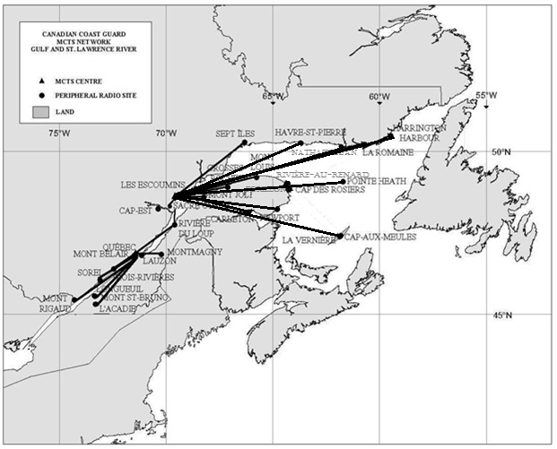
Part 2 - Numbering
AMEND
Page numbering from Les Escoumins (page 21) to page 43. Sarnia stays page 45.
Part 3 - Page 7
3.6.4.5. Exiting the Zone
REMOVE
Rivière-au-Renard MCTS Centre
Telephone : 418-269-3843
Facsimile : 418-269-5514
Email : RARECAREG@INNAV.GC.CA
TO READ:
Les Escoumins MCTS Centre
Telephone : 418-233-2194
Facsimile : 418-233-3299
Email : ECAREG.ESCOUMINS@INNAV.GC.CA
Part 3 - Page 41
REMOVE
Note: Les Escoumins, Québec and Montréal Traffic monitor navigation in the traffic zone using radar and Automatic Identification System (AIS).
TO READ
Note: Les Escoumins and Québec Traffic monitor navigation in the traffic zone using radar and Automatic Identification System (AIS).
Part 4 - Page 52
AMEND
4.3.2 Canadian NAVTEX Service
Table 4-18 – Transmitting sites where NAVTEX Service is available:
| Controlled by | Site | Position | Range (NM) | ID 518 kHz (English) |
ID 490 kHz (French) |
| St. John’s MCTS | St. John’s | 47º36’N 52º40’W | 300 | O | |
| Labrador MCTS | Cartwright | 53º42’N 57º01’W | 300 | X | |
| Sydney MCTS | Port Caledonia | 46º11’N 59º54’W | 300 | Q | J |
| Saint John MCTS | Yarmouth | 43º45’N 66º07’W | 300 | U | V |
| Rivière-au-Renard MCTS | Moisie | 50º15’N 66º10’W | 300 | C | D |
| Sarnia MCTS | Pass Lake | 48º34’N 88º39’W | 300 | P | |
| Prescott MCTS | Ferndale | 44º56’N 81º14’W | 300 | H | |
| Iqaluit MCTS | Iqaluit | 63º43’N 68º33’W | 300 | T | S |
The above noted NAVTEX services are provided on a time-shared basis for the broadcast of the following subject indicator content:
(A) Navigational Warnings
(B) Meteorological Warnings
(C) Ice Reports
(D) Search and Rescue Information/Tsunami
(E) Meteorological Forecasts
(G) AIS Service Messages
(J) GPS Messages
Broadcast time and content is shown in individual MCTS Centre listings. For Wiarton site consult Prescott MCTS listing. For Sept-Iles site consult Rivière-au-Renard MCTS listing
Table 4-18 – Transmitting sites where NAVTEX Service is available:
| Controlled by | Site | Position | Range (NM) | ID 518 kHz (English) |
ID 490 kHz (French) |
| St. John’s MCTS | St. John’s | 47º36’N 52º40’W | 300 | O | |
| Labrador MCTS | Cartwright | 53º42’N 57º01’W | 300 | X | |
| Sydney MCTS | Port Caledonia | 46º11’N 59º54’W | 300 | Q | J |
| Saint John MCTS | Yarmouth | 43º45’N 66º07’W | 300 | U | V |
| Les Escoumins MCTS | Moisie | 50º15’N 66º10’W | 300 | C | D |
| Sarnia MCTS | Pass Lake | 48º34’N 88º39’W | 300 | P | |
| Prescott MCTS | Ferndale | 44º56’N 81º14’W | 300 | H | |
| Iqaluit MCTS | Iqaluit | 63º43’N 68º33’W | 300 | T | S |
The above noted NAVTEX services are provided on a time-shared basis for the broadcast of the following subject indicator content:
(A) Navigational Warnings
(B) Meteorological Warnings
(C) Ice Reports
(D) Search and Rescue Information/Tsunami
(E) Meteorological Forecasts
(G) AIS Service Messages
(J) GPS Messages
Broadcast time and content is shown in individual MCTS Centre listings. For Wiarton site consult Prescott MCTS listing.
For Moisie site consult :Les Escoumins MCTS listing.
Part 5 - Page 39
AMEND:
Table 5-47- Production Schedule - NAVTEX Format (refer to Part 2 for the MCTS broadcast schedule)
| MCTS Centre | Name | Header | Issue Time |
| Rivière-au-Renard VCG | NAVTEX/1 | FQCN97 CWUL | 03:00, 15:00 EDT / EST |
| NAVTEX/2 | FQCN97 CWHX | 03:00, 05:00, 10:00, 15:30, 17:00, 20:00 ADT / AST | |
| NAVTEX/3 | FQCN97 CYQX | 03:00, 06:00, 10:00, 15:30, 18:00, 20:00 NDT / NST |
| MCTS Centre | Name | Header | Issue Time |
| Les Escoumins VCF | NAVTEX/1 | FQCN97 CWUL | 03:00, 15:00 EDT / EST |
| NAVTEX/2 | FQCN97 CWHX | 03:00, 05:00, 10:00, 15:30, 17:00, 20:00 ADT / AST | |
| NAVTEX/3 | FQCN97 CYQX | 03:00, 06:00, 10:00, 15:30, 18:00, 20:00 NDT / NST |
Table of Content
AMEND
Table of Content Page iii
TO READ:
| PART 2 | Facilities Information | 1 |
| 2.1 | Marine Communications and Traffic Services Centre | 1 |
| 2.1.1 Halifax, Nova Scotia | 1 | |
| 2.1.2 Iqaluit, Nunavut | 7 | |
| 2.1.3 Labrador (Goose Bay), Newfoundland and Labrador | 17 | |
| 2.1.4 Les Escoumins, Québec | 21 | |
| 2.1.5 Placentia, Newfoundland and Labrador | 27 | |
| 2.1.6 Port aux Basques, Newfoundland and Labrador | 33 | |
| 2.1.7 Prescott, Ontario | 37 | |
| 2.1.8 Québec, Québec | 41 | |
| 2.1.9 Sarnia, Ontario | 45 | |
| 2.1.10 St. Anthony, Newfoundland and Labrador | 51 | |
| 2.1.11 Sydney, Nova Scotia | 55 | |
| 2.2 | Canal And Lock Operations | 59 |
| 2.3 | Canal, Port And Lock Operations | 59 |
| 2.4 | Radio Beacon Stations Continuously in Operations | 67 |
| 2.5 | Radar Beacon (Racons) | 67 |
| 2.5.1 Atlantic Coast, Gulf and St. Lawrence River to Montréal, Eastern Arctic | 67 | |
| 2.5.2 Lake Winnipeg | 72 | |
| 2.5.3 Great Lakes (includes St. Lawrence River to Montréal) | 72 |
SAILING DIRECTIONS AND SAMLL CRAFT GUIDE CORRECTIONS
ATL 100 — General Information, Atlantic Coast, Second Edition, 2007 —
Chapter 1 — Paragraph 19, after “Dartmouth (NS) and”
Delete: Rivière-au-Renard
Replace by: Les Escoumins
(Q2015-039.1)
ATL 101 — Newfoundland — Northeast and East Coasts, Second Edition, 2013 —
Chapter 2 — Paragraph 166
Delete: “Port hand light buoy KL3 … small stone breakwater.”
(N2015-03.3)
ATL 102 — Newfoundland — East and South Coasts, Second Edition, 2008 —
Chapter 5 — In the vicinity of paragraph 106
Replace the ARNOLD’S COVE diagram with the new one provided in Section 4 of this Monthly Edition.
http://www.notmar.gc.ca/eng/services/notmar/ed072015_arnoldcove-bil.pdf
(N2015-03.6)
Chapter 5 — Paragraph 106
Delete: “A light (38.7) … west Public wharf.”
(N2015-03.7)
Chapter 5 — Paragraph 106, last line
Add: There is a stone breakwater with a bent outer end extending 125 m (410 ft) in a northerly direction
from the shore, located about 100 m (328 ft) west of the westernmost Public wharf at Arnold’s Cove. A light
(38.7) is shown from a mast on the outer end of the stone breakwater.
(N2015-03.8)
ATL 103 — Newfoundland — Southwest Coast, Second Edition, 2010 —
Chapter 1 — Paragraph 115, last line
Add: A marine farm is charted about 1.5 miles ESE of Pointes de Belliveau; caution is advised.
(N2015-03.4)
ATL 108 — Gulf of St. Lawrence (Southwest Portion), First Edition, 2006 —
Chapter 4 — Paragraph 211
Delete: 7.6 m
Replace by: 7.3 m
(Q2015-032.1)
Chapter 4 — Paragraph 211
Delete: 2.3 m
Replace by: 2.0 m
(Q2015-032.2)
Chapter 4 — Paragraph 285
Delete: 1.7 to 5 m
Replace by: 2 to 3.6 m
(Q2015-034.1)
ATL 109 — Gulf of St. Lawrence (Northeast Portion), First Edition, 2006 —
Chapter 4 — Paragraph 212
Delete: “Starboard and port hand light buoys QK2, … east of the light.”
Replace by: Starboard hand light buoys QK2 (160.1) and QK4 (160.3) mark the east approach into Motherlake Bay.
A small private fish plant and wharf are located about 300 m (984 ft) east of the north tip of Pig Island.
(N2015-03.5)
APPENDICES — Page 112, bottom of the page, “Environment” column
Delete: (418) 269-5686
Replace by: (418) 233-2194
(Q2015-039.2)
ATL 110 — St. Lawrence River — Cap Whittle/Cap Gaspé to Les Escoumins and Anticosti Island, Third Edition, 2011 —
Chapter 2 — Delete paragraph 126
Replace by: 126 A cathodic protection system to control corrosion is in operation at the public wharf and
at Quai des Pêcheurs of Les Méchins. When berthing at these wharves, certain operational procedures must be
observed to prevent damage to vessels. At the public wharf contact the wharfinger at 418-560-2953.
(Q2015-029.1)
ATL 111 — St. Lawrence River — Île Verte to Québec and Fjord du Saguenay, Third Edition, 2007 —
Chapter 2 — After paragraph 110
Insert: 110.1 Two sets of lights in line (private) with daymarks mark the limits of dredged areas that
are adjacent to Berth 86. The white lights (12696, 12697), with yellow daymarks, mark the 12.5 m dredged
area limit while the red lights (12698, 12699), with orange daymarks, mark the 6.5 m dredged area limit.
(Q2015-028.1)
Chapter 2 — Adjacent to paragraph 110.1, add a light pictograph.
(Q2015-028.2)
Chapter 2 — In the vicinity of paragraph 127, Table 2.4 Port of Québec: Private Berths
Make the following change in the “Depth” column.
| Berth | Depth m |
| 87 | 16.4 |
(Q2015-028.3)
ATL 112 — St. Lawrence River — Cap-Red to Montréal and Rivière Richelieu, Third Edition, 2009 —
Chapter 2 — Paragraph 124
Delete: 55 m
Replace by: 52 m
(Q2015-023.1)
Chapter 2 — Paragraph 124
Delete: *52 m
Replace by: *44 m
(Q2015-023.2)
APPENDICES — Replace the Summary of air obstructions for this booklet Table with the new
one provided in Section 4 of this Monthly Edition.
http://www.notmar.gc.ca/eng/services/notmar/ed072015_table_air_obstructions-en.pdf
(Q2015-023.3)
LIST OF LIGHTS, BUOYS AND FOG SIGNALS CORRECTIONS
Atlantic |
||||||||||
336 H3782 |
Baccaro Point |
E. side of entrance to Barrington Bay. 43 26 59 065 28 15 |
Mo(D) |
W |
10s |
15.0 |
15 |
White square tower, red upper portion. 14.0 |
Flash 5 s; eclipse 1 s; flash 1 s; eclipse 1 s; flash 1 s; eclipse 1 s. Visible from 207° through W., N., and E. to 127°. Operates at night only. Fog signal Blast 2 s; sil. 18 s. Horn points 200°. Chart:4241 Ed. 07/15 (F15-022) |
|
521.5 |
Halifax Harbour Smart buoy |
44 33 31.3 063 32 43.9 |
Fl |
Y |
25s |
..... |
..... |
ODAS, yellow. |
Flash 5s; eclipse. 20s. Private ODAS. Chart:4203 Edn. 07/15 (F15-020) |
|
752.6 H3359 |
Rouse Point |
45 50 35.0 060 07 56.8 |
LFl |
Y |
6s |
9.0 |
12 |
Square skeleton tower, red with white band. |
Seasonal. Chart:4375 Edn. 07/15(G15-024) |
|
953.5 |
Wheeler Bar - light buoy NH3 |
46 09 31.1 062 29 34.5 |
Fl |
G |
4s |
..... |
..... |
Green spar,marked "NH3". |
Winter spar. Seasonal. (In place year round). Chart:4422 Edn. 07/15 (G15-041) |
|
979 980 |
Pinette River - outer range |
| | | | | | | | | | |
Delete from list. Chart:4466 Edn. 07/15 (G15-045, 046) |
|||||||
1060.15 |
New London – light buoy JM11 |
46 30 37.6 063 28 56.5 |
Q |
G |
1s |
..... |
..... |
Green, marked "JM11". |
Seasonal. Buoy may be repositioned due to shifting channel. Operates 24 hrs. Chart:4467 Edn. 07/15(G15-058) |
|
1069.5 |
Darnley Basin - Outer light buoy JU3 |
Basin entrance. 46 33 46.3 063 41 37.6 |
Q |
G |
1s |
..... |
..... |
Green spar, marked "JU3". |
Seasonal. Buoy may be repositioned due to shifting channel. Chart:4491 Edn. 07/15(G15-057) |
|
1072.59 |
Conway Inlet light buoy JS40 |
46 39 25.4 065 53 47.4 |
Fl |
R |
4s |
..... |
..... |
Red, marked "JS40". |
Seasonal. Buoy may be repositioned due to shifting channel. Chart:4491 Edn 07/15 (G15-052) |
|
1125.17 |
Buctouche Harbour - light buoy XV16 |
46 27 56.6 064 39 05.9 |
Fl |
R |
4s |
..... |
..... |
Red, marked "XV16". |
Seasonal. Buoy may be repositioned due to shifting channel. Chart:N/A Edn. 07/15 |
|
1125.21 |
Buctouche Harbour – light buoy XV19 |
46 28 05.7 064 39 24.4 |
Fl |
G |
4s |
..... |
..... |
Green, marked "XV19". |
Seasonal. Buoy may be repositioned due to shifting channel. Chart:N/A Edn. 07/15 |
|
1125.23 |
Buctouche Harbour – light buoy XV23 |
46 28 34.0 064 40 03.0 |
Q |
G |
1s |
..... |
..... |
Green, marked "XV23". |
Seasonal. Buoy may be repositioned due to shifting channel. Chart:N/A Edn. 07/15 |
|
1173.72 |
Miramichi Bar – light buoy M15/1 |
47 08 22.8 065 00 07.4 |
Q |
G |
1s |
..... |
..... |
Green spar, marked "M15/1". |
Seasonal. (In place Year round). Chart:N/A Edn. 07/15 |
|
1238.05 |
Tabusintac light buoy TA2/2 |
47 18 56.3 064 55 21.1 |
Q |
R |
1s |
..... |
..... |
Red spar, marked "TA2/2". |
Seasonal. Buoy may be repositioned due to shifting channel. Chart: 4906 Edn. 07/15(G15-059) |
|
1238.1 |
Tabusintac South Gully Approach - light buoy TA4 |
47 18 59.3 064 55 24.0 |
Fl |
R |
4s |
..... |
..... |
Red, marked "TA4". |
Seasonal. Buoy may be repositioned due to shifting channel. Chart:N/A Edn.07/15(G15-061) |
|
1238.13 |
Tabusintac - light buoy TA6 |
47 19 01.7 064 55 27.2 |
Fl |
R |
4s |
..... |
..... |
Red spar, marked "TA6". |
Seasonal. Buoy may be repositioned due to shifting channel. Chart:N/A Edn 07/15(G15-060) |
|
1238.17 |
Tabusintac - light buoy TA10 |
47 19 04.7 064 55 32.3 |
Fl |
R |
4s |
..... |
..... |
Red spar, marked "TA10". |
Seasonal. Buoy may be repositioned due to shifting channel. Chart:N/A Edn. 07/15 (G15-062) |
|
1238.2 |
Tabusintac South Gully Approach - light buoy TA12 |
47 19 07.3 064 55 37.3 |
Fl |
R |
4s |
..... |
..... |
Red,marked "TA12". |
Seasonal. Buoy may be repositioned due to shifting channel. Chart:N/A Edn. 07/15 (G15-063) |
|
1238.24 |
Tabusintac - light buoy TA16 |
47 19 09.7 064 55 50.1 |
Fl |
R |
4s |
..... |
..... |
Red,marked "TA16". |
Seasonal. Buoy may be repositioned due to shifting channel. Chart:N/A Edn. 07/15(G15-064) |
|
1238.26 |
Tabusintac South Gully - light buoy TA18 |
47 19 09.7 064 55 57.2 |
Fl |
R |
4s |
..... |
..... |
Red, marked "TA18". |
Seasonal. Buoy may be repositioned due to shifting channel. Chart:N/A Edn. 07/15(G15-065) |
|
1238.28 |
Tabusintac - light buoy TA20 |
47 19 12.5 064 56 07.7 |
Q |
R |
1s |
..... |
..... |
Red,marked "TA20". |
Seasonal. Buoy may be repositioned due to shifting channel. Chart:N/A Edn. 07/15 (G15-066) |
|
1238.29 |
Tabusintac - light buoy TA21 |
47 19 11.9 064 56 07.4 |
Fl |
G |
4s |
..... |
..... |
Green, marked "TA21". |
Seasonal. Buoy may be repositioned due to shifting channel. Chart:4906 Edn. 07/15(G15-078) |
|
1238.3 |
Tabusintac South Gully - light buoy TA22 |
47 19 17.8 064 56 08.1 |
Q |
R |
1s |
..... |
..... |
Red,marked "TA22". |
Seasonal. Buoy may be repositioned due to shifting channel. Chart:N/A Edn. 07/15 (G15-067) |
|
1238.4 |
Tabusintac Gully - light buoy TA23 |
47 19 19.7 064 56 12.8 |
Fl |
G |
4s |
..... |
..... |
Green spar,marked "TA23". |
Seasonal. Buoy may be repositioned due to shifting channel. Chart:N/A Edn. 07/15(G15-079) |
|
1238.6 |
Tabusintac Bay - light buoy TA37 |
47 19 51.4 064 56 10.0 |
Q |
G |
1s |
..... |
..... |
Green, marked “TA37”. |
Seasonal. Buoy may be repositioned due to shifting channel. Chart:N/A Edn. 07/15(G15-082) |
|
1238.65 |
Tabusintac Bay - light buoy TA39 |
47 20 02.5 064 56 18.4 |
Fl |
G |
4s |
..... |
..... |
Green spar, marked "TA39". |
Seasonal. Buoy may be repositioned due to shifting channel. Chart:N/A Edn. 07/15(G15-081) |
|
1238.66 |
Tabusintac Bay - light buoy TA41 |
47 20 19.9 064 56 55.2 |
Fl |
G |
4s |
..... |
..... |
Green spar,marked "TA41". |
Seasonal. Buoy may be repositioned due to shifting channel. Chart:N/A Edn. 07/15(G15-080) |
|
1248.12 |
Shippegan South Gully – light buoy TJ5 |
47 42 45.3 064 39 36.1 |
Fl |
G |
4s |
..... |
..... |
Green spar,marked "TJ5". |
Seasonal. Buoy may be repositioned due to shifting channel. Chart:N/A Edn. 07/15(G15-083) |
|
1248.13 |
Shippegan South Gully - light buoy TJ6 |
47 42 49.9 064 39 39.1 |
Fl |
R |
4s |
..... |
..... |
Red, marked "TJ6". |
Seasonal. Buoy may be repositioned due to shifting channel. Chart:N/A Edn. 07/15(G15-084) |
|
1248.15 |
Shippegan Gully - light buoy TJ8 |
47 42 52.2 64 39 42.2 |
Fl |
R |
4s |
..... |
..... |
Red spar,marked "TJ8". |
Seasonal. Buoy may be repositioned due to shifting channel. Chart:N/A Edn. 07/15(G15-085) |
|
1248.71 |
Shippegan South Gully light buoy TJ12 |
47 43 10.3 064 40 02.1 |
Fl |
R |
4s |
..... |
..... |
Red, marked "TJ12". |
Seasonal. Buoy may be repositioned due to shifting channel. Chart:N/A Edn. 07/15(G15-086) |
|
1319 |
Young, Wharf |
SE corner. 47 47 48.9 064 55 31.3 |
Q |
R |
1s |
7.5 |
9 |
Mast, triangular day mark red, white and red. 7.1 |
Seasonal. Chart:4920 Edn. 07/15 (G15-055) |
|
1823.63 |
St-Prime FR |
48 36 03.3 072 19 19.3 |
F |
R |
..... |
7.0 |
..... |
Mast. |
Private. Seasonal. Chart:6100 Edn. 07/15 (Q15-084) |
|
1890.47 |
St-Thomas de Montmagny - light buoy HM5 |
47 00 00.9 070 33 18.7 |
Fl |
G |
4s |
..... |
..... |
Green, marked "HM5”. |
Seasonal. Chart:1317 Edn. 07/15 (Q15-058) |
|
1890.5 |
Montmagny - light buoy HM2 |
47 00 09.1 070 33 27.0 |
Fl |
R |
4s |
..... |
..... |
Red, marked "HM2". |
Seasonal. Chart:1317 Edn. 07/15 (Q15-059) |
|
Inland Waters |
||||||||||
711 |
Belle River, Pier |
42 18 07.3 082 42 32.8 |
Fl |
R |
5s |
9.9 |
6 |
White cylindrical tower, red upper portion. 7.2 |
Privately maintained. Flash 1.5 s; eclipse 3.5 s. Seasonal. Chart:14850(U.S.) Edn. 07/15 (B15-001) |
|
|
CANADIAN COAST GUARD MARINE INFORMATION REPORT AND SUGGESTION SHEET. |
Name of Ship or Sender:..................................................................... Date:....................................
Address of Sender:..........................................................................................................................
Street # Street Name
Town / City:.............................. Prov / State:....................... Postal Code / Zip Code: ........................
Tel / Fax / E-mail address of sender (if appropriate):............................................................................
Observation Date:............................................. Time (UTC): ...........................................................
Geographical Position:......................................................................................................................
Coordinate Position: Lat: ............................................... Long:.........................................................
Position Method: q DGPS q GPS with WAAS q GPS q Radar qOther
Horizontal Datum Used: qWGS 84 q NAD 27 q Other
Estimated Position Accuracy:............................................................................................................
Chart #:............................................................ Datum: q NAD 27 q NAD 83
Chart Edition:.................................................... Last Correction applied:............................................
Publications affected: (Quote Volume and page):.................................................................................
*Full details (Attach additional sheets as necessary)............................................................................
Mariners are requested to notify the responsible authorities when new or suspected dangers to navigation are discovered, changes are observed in aids to navigation, or corrections to publications are seen to be necessary.
In the case of new or suspected dangers to navigation, it is important that all details be given in order to aid with future investigations. Items of interest include heights, depths, physical description, type of bottom and equipment method used to position the item. It is helpful to mark details on chart, which will be promptly replaced by the Canadian Hydrographic Service.
Reports should be made to the nearest Marine Communications and Traffic Services Centre (MCTS) and should be confirmed in writing to:
|
Leader, Notices to Mariners Canadian Coast Guard Department of Fisheries and Oceans Montréal, Qc H2Y 2E7 |
In the case of information concerning aids to navigation or the List of Lights, Buoys and Fog Signals. |
|
OR |
|
Dominion Hydrographer Canadian Hydrographic Service Department of Fisheries and Oceans Ottawa, Ontario, K1A 0E6 |
In the case of new or suspected dangers to navigation or where corrections to "Sailing Directions" appear to be necessary. |
Or general questions on Coast Guard programs or services please send an e-mail message to:
info@dfo-mpo.gc.ca (Please include your postal code and e-mail address).