
Archived information
The Standard on Web Usability replaces this content. This content is archived because Common Look and Feel 2.0 Standards have been rescinded.
Archived information is provided for reference, research or recordkeeping purposes. It is not subject to the Government of Canada Web Standards and has not been altered or updated since it was archived.
|
|
Fisheries and Oceans Canada |
Pêches et Océans Canada |
VOL. 36, MONTHLY EDITION NO 06 June 24, 2011 Publication Number 40063779 |
NOTICES TO MARINERS
PUBLICATION EASTERN EDITION |
|||
Published monthly by the
CANADIAN COAST GUARD |
|||
|
|
|||
Page |
|||
| Section 1 |
Safety and General Information | 1 - 5 |
|
| Section 2 |
Chart Corrections | 6 - 18 |
|
| Section 3 |
Corrections to Radio Aids to Marine Navigation | 19 - 24 |
|
| Section 4 |
Sailing Directions and Small Craft Guide Corrections | 25 - 36 |
|
| Section 5 |
List of Lights, Buoys and Fog signals Corrections | 37 - 41 |
|
Maritime Services Directorate Aids to Navigation |
|||
EXPLANATORY NOTES |
Geographical positions refer directly to the graduations of the largest scale Canadian Hydrographic chart unless otherwise indicated. |
Bearings refer to the true compass and are measured clockwise from 000° (North) clockwise to 359°; those relating to lights are from seaward. |
Visibility of lights is that in clear weather. |
Depths - The units used for soundings (metres, fathoms or feet) are stated in the title of each chart. |
Elevations are normally given above Higher High Water, Large Tides unless otherwise indicated. |
Distances may be calculated as follows: |
1 nautical mile = 1 852 metres (6,076.1 feet) 1 statute mile = 1 609.3 metres (5,280 feet) 1 metre = 3.28 feet |
Temporary & Preliminary Notices are indicated by a (T) or a (P) before the chart action and in the section 1. Please note that Nautical charts are not amended by the Canadian Hydrographic Service for Temporary (T) and Preliminary (P) Notices. It is recommended that mariners chart these corrections in pencil. Listing of charts affected by Temporary and Preliminary Notices are revised and promulgated quarterly in Section 1 of the Monthly Edition . |
Please note that, in addition to the temporary and preliminary changes normally advertised as (T) and (P) Notices, there are a few permanent changes to navigational aids that have been advertised as Preliminary Notices to Mariners while charts are being updated for new editions. |
Marine Information Report & Suggestion Sheet - Mariners are requested to notify the responsible authorities when new or suspected dangers to navigation are discovered, changes observed in aids to navigation or corrections to publications are seen to be necessary. Such communications can be made using the Marine Information Report & Suggestion Sheet inserted on the last page of each monthly edition of Notices to Mariners. |
Monthly Notices to Mariners - WEB ACCESS -We are offering a feature where subscribers to our on-line service are able to receive the complete electronic monthly edition of our Notices to Mariners. We are encouraging our clients to visit the http://www.notmar.gc.ca/subscribe/ user-friendly web site to subscribe for this service. Users wishing to receive information updates for their charts can do so by setting up a "User Profile" on the following web page – http://www.notmar.gc.ca/search/mycharts-eng.php?czoxOToibnRtPXN0ZXBfb25lJmxhbmc9ZSI7. This feature permits users to register the nautical charts they currently have in their possession. Registrants are then automatically notified by e-mail when a Notices to Mariners is published concerning these charts. |
Canadian Nautical Charts & Publications - A source list of Canadian Nautical Charts & publications is published in Notice No. 14 of the Notices to Mariners Annual Edition April 2010. The source supply and the prices effective at the time of printing are listed. For current chart edition dates refer to the following web site: http://www.chs-shc.gc.ca/charts-cartes/paper-papier/index-eng.asp |
NOTE: Cette publication est aussi disponible en français. |
CHART CORRECTIONS - SECTION 2 |
|
Corrections to nautical charts will be listed in numeric order by chart number. Each chart correction listed applies only to that particular chart. Related charts, if any, will have their own specific correction listed separately. Users should also refer to CHS Chart 1 Symbols, Abbreviations Terms for additional information pertaining to the correction of charts. The illustration below describes the elements that will comprise a typical Section 2 chart correction. |

ADVISORY |
|
NOTICES TO SHIPPING (WRITTEN AND BROADCAST) |
|
The Canadian Coast Guard is implementing a number of changes to the aids to navigation system in Canada . |
|
These changes are advertised as Notices to Shipping (Broadcast and Written) by the Canadian Coast Guard and are followed up with Notices to Mariners, then charts are updated by hand correction, reprints or new editions. |
|
Mariners are advised that all relevant Written Notices to Shipping should be kept until superseded by Notices to Mariners or through revised charts issued by the Canadian Hydrographic Service. |
|
Written Notices to Shipping are published weekly and are available from local Canadian Coast Guard Offices. |
|
The Canadian Hydrographic Service is reviewing the impact of these changes with the Canadian Coast Guard and together we are preparing an action plan on the issuing of chart revisions. |
|
For further information contact your local Regional Notices to Shipping (Notships) issuing authorities. |
|
|

|
MONTHLY EDITION OF NOTICES TO MARINERS |
WEB ACCESS |
We are offering a feature where subscribers to our on-line service are able to receive the complete electronic monthly edition of our Notices to Mariners. We are encouraging our clients to visit the http://www.notmar.gc.ca /subscribe / web site to subscribe for this service. Users wishing to receive information updates for their charts can do so by setting up a "User Profile" on the following web page http://www.notmar.gc.ca/search/mycharts-eng.php?czoxOToibnRtPXN0ZXBfb25lJmxhbmc9ZSI7 This feature permits users to register the nautical charts they currently have in their possession. Registrants are then automatically notified by e-mail when a Notice to Mariners is published concerning these charts. |
INDEX |
|
CANADIAN HYDROGRAPHIC SERVICE - ANNOUNCEMENT REGARDING CANADIAN HYDROGRAPHIC SERVICE CHART PATCHES |
1 |
CANADIAN HYDROGRAPHIC SERVICE - CUMULATIVE CHART CORRECTIONS |
1 |
CANADIAN HYDROGRAPHIC SERVICE - CURRENT CHART EDITION DATES |
1 |
CANADIAN HYDROGRAPHIC SERVICE - PRINT ON DEMAND CHARTS - CARE AND USE |
1 |
CANADIAN HYDROGRAPHIC SERVICE - TRANSPORT CANADA NAVIGATION SAFETY - ECDIS |
1 |
*610 CANADIAN COAST GUARD PUBLICATION - AMENDMENT TO THE RADIO AIDS TO MARINE NAVIGATION (ATLANTIC, ST. LAWRENCE, GREAT LAKES, LAKE WINNIPEG AND EASTERN ARCTIC) PUBLICATION - 2011 |
19 |
*602 CANADIAN HYDROGRAPHIC SERVICE - ELECTRONIC NAVIGATIONAL CHARTS |
2 |
*601 CANADIAN HYDROGRAPHIC SERVICE - NAUTICAL CHARTS |
2 |
*603 CANADIAN HYDROGRAPHIC SERVICE - RASTER DIGITAL CHARTS (BSB V4) |
2 |
*604 CANADIAN HYDROGRAPHIC SERVICE - SAILING DIRECTIONS - CEN 302E IS NOW AVAILABLE IN PRINT-ON- DEMAND FORMAT |
3 |
*606 ENVIRONMENT CANADA - EXPANSION OF MARINE FORECAST SERVICE TO SECTIONS OF METAREAS XVII AND XVIII |
3 |
*605 ENVIRONMENT CANADA - METAREAS XVII AND XVIII |
3 |
*607 GREAT BRAS D'OR AND / ET ST. PATRICKS CHANNEL - LIGHT DISCONTINUED |
5 |
*609 PLANS BAIE DES CHALEURS / CHALEUR BAY - CÔTE SUD / SOUTH SHORE - BUOY ESTABLISHED |
5 |
*608 ST. PETERS BAY TO / À STRAIT OF CANSO - SPAR BUOYS DISCONTINUED |
5 |
NUMERICAL INDEX OF CANADIAN CHARTS AFFECTED |
|||||
Chart No. |
Page |
Chart No. |
Page |
Chart No. |
Page |
1429 |
6 |
4485 |
13 |
||
1430 |
6 |
4486 |
13 |
||
1431 |
6 |
4529 |
13 |
||
3710 |
2 |
4821 |
13 |
||
3711 |
2 |
4839 |
13 |
||
3719 |
2 |
4852 |
13 |
||
3723 |
2 |
4853 |
13 |
||
3910 |
2 |
4857 |
14 |
||
3911 |
2 |
4905 |
14 |
||
4001 |
6,7 |
4906 |
14 |
||
4003 |
7 |
4909 |
14 |
||
4006 |
7 |
L/C 4913 |
15 |
||
4010 |
7 |
4920 |
5,15 |
||
4011 |
7 |
4921 |
15 |
||
4020 |
7 |
4956 |
15-17 |
||
4236 |
8 |
5412 |
17 |
||
4237 |
8 |
6248 |
17 |
||
4277 |
9 |
6249 |
17 |
||
4278 |
5,9 |
6286 |
17,18 |
||
4306 |
9 |
6287 |
18 |
||
4307 |
9,10 |
8005 |
18 |
||
4308 |
5,10,11 |
||||
L/C 4320 |
11,12 |
||||
4335 |
12 |
||||
4381 |
12 |
||||
4386 |
12 |
||||
4422 |
13 |
||||
CANADIAN HYDROGRAPHIC SERVICE - ANNOUNCEMENT REGARDING CANADIAN HYDROGRAPHIC SERVICE CHART PATCHES
Colour Web Patches are free to the mariner, and given the quality of many printers, should reproduce well. They will be available in real time all around the world.
CHS welcomes your feedback on this service at chsinfo@dfo-mpo.gc.ca
CANADIAN HYDROGRAPHIC SERVICE - CUMULATIVE CHART CORRECTIONS
The cumulative Notices to Mariners corrections for charts can now be accessed at
http://www.notmar.gc.ca/search/notmar-eng.php
CANADIAN HYDROGRAPHIC SERVICE - CURRENT CHART EDITION DATES
CHART EDITIONS |
The three terms described below are used to indicate the publication status of Canadian charts. |
NEW CHART - "NEWCHT" |
The first publication of a Canadian chart embracing an area not previously charted to the scale shown, or embracing an area different from any existing Canadian chart. |
NEW EDITION - "NEWEDT" |
A new issue of an existing chart containing amendments essential to navigation in addition to those issued in Notices to Mariners and making existing editions obsolete. |
REPRINTS |
A new issue of the current edition of a chart incorporating no amendments of navigational significance other than those previously promulgated in Notices to Mariners. It may also contain amendments from other sources provided they are not essential to navigation. Previous printings of the current edition remain in force. |
The current chart edition dates can be accessed at http://www.chs-shc.gc.ca/charts-cartes/paper-papier/index-eng.asp
CANADIAN HYDROGRAPHIC SERVICE - PRINT ON DEMAND CHARTS - CARE AND USE
Background By providing nautical charts to the public, the goal of the Canadian Hydrographic Service (CHS) is to provide services for safe navigation in a fiscally responsible manner. As a result, CHS continues to expand its portfolio of nautical paper charts that are printed using Print On Demand (POD) technology. These charts are easily recognized by their whiter paper and the coloured logo of the Canadian Hydrographic Service. This new technology enables CHS to print charts in a more efficient manner while enhancing chart content through being able to quickly add new and important information. POD technology provides customers with up-to-date charts without the historical hand-drawn corrections or glued-on patches. Additionally, this technology eliminates out-of-stock situations which arise with the traditional printing and warehousing methods. In the event of a national emergency, CHS can respond to the appropriate authorities with best available information very quickly. Care of Your POD Chart CHS encourages its customers to handle the POD charts more carefully than the traditional lithographic charts. When plotting information on POD charts, use HB pencils and apply limited pressure. Testing has suggested that an Indian gum eraser is more effective than alternatives when used on the product. This eraser is also suitable for charts printed using lithographic processes. |
CANADIAN HYDROGRAPHIC SERVICE - TRANSPORT CANADA NAVIGATION SAFETY - ECDIS
Mariners are advised that ECDIS may not display some isolated shoal depths when operating in "base or standard display" mode. Route planning and monitoring alarms for these shoal depths may not always be activated. To ensure safe navigation and to confirm that a planned route is clear of such dangers, mariners should visually inspect the planned route and any deviations from it using ECDIS configured to display "all data". The automated voyage planning check function should not be solely relied upon. |
*601 CANADIAN HYDROGRAPHIC SERVICE - NAUTICAL CHARTS
CHARTS |
MAIN TITLE |
SCALE |
PUBLISHED |
CAT# |
PRICE |
New Charts |
All temporary and preliminary notices affecting the previous versions of the following chart(s) (is / are) now cancelled. For any outstanding notices please consult section 2 of this edition. |
||||
3910 |
Plans - Milbanke Sound and/et Beauchemin Channel |
---- |
01-APR-2011 |
2 |
$20.00 |
3911 |
Plans Vicinity of/Proximité de Princess Royal Island |
---- |
01-OCT-2010 |
2 |
$20.00 |
Charts Permanently Withdrawn |
|||||
3710 |
Plans - Vicinity of/Proximité de Laredo Sound and/et Milbanke Sound |
||||
3711 |
Plans - Vicinity of/Proximité de Princess Royal Island |
||||
3719 |
Inlets in Campania and Princess Royal Islands |
||||
3723 |
Plans - Hecate Strait, East Shore/Côte Est |
||||
*602 CANADIAN HYDROGRAPHIC SERVICE - Electronic Navigational Charts
RELEASED PRODUCTS |
|
S-57 ENC NUMBER |
CHART TITLE |
CA573361 |
Gananoque Harbour |
CA573395 |
Pangnirtung |
CA573406 |
Grise Fiord |
CA276821 |
Murphy Head to Button Islands |
CA570175 |
Okeover Inlet |
CA570186 |
Bedwell Harbour to/à Georgeson Passage |
CA570383 |
Nanaimo Harbour and/et Departure Bay |
CA570562 |
Victoria Harbour |
CA473025 |
Grindstone Island to/à Carleton Island |
CA473043 |
Bayfield Sound |
CA373086 |
Cape Gargantua to/à Otter Head |
CA476218 |
Ticorolak Island to Carrington Island |
CA176290 |
Labrador Sea/Mer du Labrador |
CA376483 |
Davis Inlet to/aux Seniarlit Islands |
CA376808 |
Bonavista Bay, Southern Portion |
CA476814 |
Carmanville to Bacalhoa Island and Fogo (Northern Portion) |
CA579041 |
Rimouski, Pointe-au-Père |
*603 CANADIAN HYDROGRAPHIC SERVICE - RASTER DIGITAL CHARTS (BSB V4)
CHARTS |
MAIN TITLE |
PUBLISHED |
|||
New Charts |
All temporary and preliminary notices affecting the previous versions of the following chart(s) (is / are) now cancelled. For any outstanding notices please consult section 2 of this edition. |
||||
R/M3860 |
Harbours on the West Coast of/Havres sur la côte ouest de Graham Island |
24-JUN-2011 |
|||
R/M5027 |
Murphy Head to/aux Button Islands |
24-JUN-2011 |
|||
*604 CANADIAN HYDROGRAPHIC SERVICE - SAILING DIRECTIONS - CEN 302E IS NOW AVAILABLE IN PRINT-ON-DEMAND FORMAT
The Sailing Directions booklet CEN 302E - Lake Ontario, First Edition, 1996 is now available as Print-on-Demand (POD) product. POD booklets are updated through Notices to Mariners to the date of printing. For instance, the POD version of CEN 302 now incorporates some 145 Notices issued since 1996, which previously had to be manually added to the book. The Canadian Hydrographic Service (CHS) is converting all of its Sailing Directions to the POD format in response to requests received through our Level of Service initiative. Contact an authorized CHS dealer to purchase a new copy. Please note that despite the new look, the content remains the same except that the Notices to Mariners have been incorporated up to the date of printing. |
*605 ENVIRONMENT CANADA - METAREAS XVII AND XVIII
Notification of Full Operational Capability of METAREA XVII and XVIII - Canada.
Commencing on 01 June 2011 marine forecast service to METAREA XVII and XVIII will transition to Full Operational Capability. Meteorological warnings and forecasts for METAREA XVII and XVIII will be promulgated by Environment Canada in accordance with the joint IMO/IHO/WMO Maritime Safety Information manual.
During the navigation season meteorological warnings and forecasts for sections of METAREA XVII and XVIII south of 75 degrees latitude will be broadcast via Inmarsat-C EGC SafetyNET. Scheduled broadcast times are:
METAREA XVII (POR) at 0300 UTC and 1500 UTC daily.
METAREA XVIII (AOR-W) at 0300 UTC and 1500 UTC daily.
Messages will be transmitted to a rectangular addressed area until Inmarsat-C or Mini-C terminals operating in Arctic waters have been updated. Users should note that meteorological MSI received by their Sat-C terminals may be labelled as navigational MSI.
During the navigation season meteorological warnings and forecasts for sections of METAREA XVII and XVIII north of 70 degrees latitude will be broadcast via HF Narrow Band Direct Printing on 8416.5 kHz from the Canadian Coast Guard centre in Iqaluit NU. Scheduled broadcast times are 0330 UTC and 1530 UTC daily.
Mariners should note that actual HF service provision dates will be announced by Canadian Coast Guard notice to shipping.
Contact information for METAREA XVII and XVIII is:
phone: +1 709 256 6612
fax: +1 709 256 6627
email: metareas17.18@ec.gc.ca
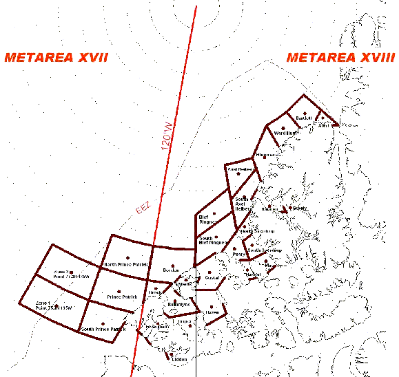
*606 ENVIRONMENT CANADA - EXPANSION OF MARINE FORECAST SERVICE TO SECTIONS OF METAREAS XVII AND XVIII
Effective June 28, 2011 at 1600 UTC the following METAREAS forecast bulletins will be modified to include new forecast zones.
At this time bulletins are available in English only.
Telecommunication Header / Bulletin Title / New Forecast Zones:
FQCN01 CWNT - marine forecasts for METAREA XVII north of 75N - Zone 1 centred on 75.7N135W, Zone 2 centred on 77.3N135W, South Prince Patrick, Prince Patrick, North Prince Patrick.
FQCN03 CWNT - marine forecasts for METAREA XVIII north of 75N - Fitzwilliam, Griper, Ballantyne, Brock, Wilkins, Borden, Hazen, Gustaf, Peary, South Ellef Ringnes, Ellef Ringnes, Hassel, Massey, South Sverdrup, North Sverdrup, South Axel Heiberg, Axel Heiberg, Greely, Nansen, Ellesmere, Ward Hunt, Bartlett, Alert.
FQCN04 CWNT - marine forecasts for METAREA XVIII south of 75N - Liddon.
These new marine forecast zones are generally located between the northwestern Canadian Arctic archipelago and the Canadian Exclusive Economic Zone boundary.
Detailed information regarding the geographic boundaries associated with these new marine zones may be obtained by contacting the Meteorological Service of Canada at the following:
Telephone: +1 (709) 256-6612
Facsimile: +1 (709) 256-6627
Email: metareas17.18@ec.gc.ca
Or by consulting the Joint Commission on Oceanography and Marine Meteorology (JCOMM) web site at http://weather.gmdss.org or by consulting the Canadian Coast Guard notices to mariners (NOTMAR) web site at http://notmar.gc.ca.
Fig. 1: Map of the new high Arctic marine forecast zones.
PDF format http://www.notmar.gc.ca/eng/services/notmar/6s1e1100.pdf or
GIF format - http://www.notmar.gc.ca/eng/services/notmar/6s1e1100.gif
Table 1: Names of the new high Arctic marine forecast zones.
High Arctic Waters |
201 Zone 1 centred on 75.7° N 135° W 202 Zone 2 centred on 77.3° N 135° W 203 South Prince Patrick 204 Prince Patrick 205 North Prince Patrick 206 Liddon 207 Fitzwilliam 208 Griper 209 Ballantyne 210 Brock 211 Wilkins 212 Borden 213 Hazen 214 Gustaf 215 Peary 216 South Ellef Ringnes 217 Ellef Ringnes 218 Hassel 219 Massey 220 South Sverdrup 221 North Sverdrup 222 South Axel Heiberg 223 Axel Heiberg 224 Greely 225 Nansen 226 Ellesmere 227 Ward Hunt 228 Bartlett 229 Alert |
*607 GREAT BRAS D'OR AND / ET ST. PATRICKS CHANNEL - LIGHT DISCONTINUED
Reference: Notice 1013(P)/10 is now cancelled (Chart 4278) (G2011-121) |
*608 ST. PETERS BAY TO / À STRAIT OF CANSO - SPAR BUOYS DISCONTINUED
Reference: Chart 4308 The following spar buoys have been discontinued: Jerseyman Shoal red spar buoy CM2 (45°29'46.3"N 61°04'17.7"W) Hautfond Shoal red spar buoy CK2 (45°29'00.3"N 61°03'21.6"W) Crichton Head red spar buoy CN6 (45°30'53.5"N 61°06'22"W) Isle Madame green spar buoy CN5 (45°30'53.2"N 61°06'40.6"W) (G2011- 148,150, 155, 157) |
*609 PLANS BAIE DES CHALEURS / CHALEUR BAY - CÔTE SUD / SOUTH SHORE - BUOY ESTABLISHED
Reference: Chart 4920 Shippegan Gully red conical buoy marked TJ22 has been established (47°43'08.6"N 64°39'59.3"W) (G2011- 142) |
CHART CORRECTIONS
1429 - Canal de la Rive Sud - New Chart - 09-APR-2010 - NAD 1983
17-JUN-2011 |
||
Add |
legend Mooring Buoys (See Chart No. 1, Q44) |
45°26'09.7"N 073°43'31.8"W |
DFO(6408365-01) |
||
This notice might affect Electronic Navigational Chart: CA579227 |
||
Add |
light Fl Y(Priv) (See Chart No. 1, P65) |
45°26'51.0"N 073°34'06.8"W |
(Q2011070) DFO(6408377-01) |
||
This notice might affect Electronic Navigational Chart: CA579227 |
||
1430 - Lac Saint-Louis - New Chart - 16-APR-2010 - NAD 1983
17-JUN-2011 |
LNM/D. 22-APR-2011 |
|
Delete |
depth of 0 metres 9 decimetres (See Chart No. 1, I10) |
45°20'04.0"N 073°51'10.7"W |
DFO(6408352-02) |
||
This notice might affect Electronic Navigational Chart: CA479228 |
||
Add |
depth of 0 metres 3 decimetres (See Chart No. 1, I10) |
45°20'04.0"N 073°51'10.6"W |
DFO(6408352-03) |
||
This notice might affect Electronic Navigational Chart: CA479228 |
||
Delete |
depth of 0 metres 9 decimetres (See Chart No. 1, I10) |
45°19'54.5"N 073°50'51.1"W |
DFO(6408352-04) |
||
This notice might affect Electronic Navigational Chart: CA479228 |
||
Add |
depth of 0 metres 2 decimetres (See Chart No. 1, I10) |
45°19'54.6"N 073°50'51.3"W |
DFO(6408352-05) |
||
This notice might affect Electronic Navigational Chart: CA479228 |
||
Add |
legend Mooring Buoys (See Chart No. 1, Q44) |
45°26'09.7"N 073°43'31.8"W |
DFO(6408365-01) |
||
This notice might affect Electronic Navigational Chart: CA479228 |
||
1431 - Canal de Beauharnois - New Chart - 17-JAN-2003 - NAD 1983
17-JUN-2011 |
LNM/D. 21-JAN-2011 |
|
Delete |
private orange spar buoy (See Chart No. 1, Q70) |
45°12'17.0"N 074°09'49.8"W |
DFO(6603682-01) |
||
This notice might affect Electronic Navigational Chart: CA473300 |
||
4001 - Gulf of Maine to Strait of Belle Isle /au Detroit de Belle Isle - New Edition - 01-DEC-1995 - NAD 1983
03-JUN-2011 |
LNM/D. 25-MAR-2011 |
|
Delete |
wreck, least depth unknown (See Chart No. 1, K29) |
40°22'21.0"N 072°20'00.4"W |
DFO(6305443-01) |
||
This notice might affect Electronic Navigational Chart: CA176030 |
||
Add |
wreck WK with known depth of 40 metres (See Chart No. 1, K26) |
40°24'04.9"N 072°22'14.1"W |
DFO(6305443-02) |
||
This notice might affect Electronic Navigational Chart: CA176030 |
||
Delete |
light (See Chart No. 1, P1) |
41°10'17.3"N 071°34'42.6"W |
DFO(6305468-01) |
||
This notice might affect Electronic Navigational Chart: CA176030 |
||
4003 - Cape Breton to/à Cape Cod - New Edition - 21-MAR-2003 - NAD 1983
03-JUN-2011 |
LNM/D. 06-MAY-2011 |
|
Delete |
yellow cautionary lighted pillar buoy Fl Y (See Chart No. 1, Qm) |
41°42'07.1"N 069°35'31.8"W |
DFO(6305467-01) |
||
This notice might affect Electronic Navigational Chart: CA176140 |
||
24-JUN-2011 |
LNM/D. 03-JUN-2011 |
|
Delete |
yellow cautionary pillar light and whistle buoy Fl Y, WHIS (See Chart No. 1, Qm) |
40°48'57.0"N 069°00'25.0"W |
DFO(6305532-01) |
||
This notice might affect Electronic Navigational Chart: CA176140 |
||
4006 - Newfoundland and Labrador / Terre-Neuve-et-Labrador to Bermuda / aux Bermudes - New Edition - 08-AUG-2003 - NAD 1983
03-JUN-2011 |
LNM/D. 25-MAR-2011 |
|
Delete |
wreck, least depth unknown (See Chart No. 1, K29) |
40°22'21.0"N 072°20'00.4"W |
DFO(6305443-01) |
||
Add |
wreck WK with known depth of 40 metres (See Chart No. 1, K26) |
40°24'04.9"N 072°22'14.1"W |
DFO(6305443-02) |
||
Delete |
light (See Chart No. 1, P1) |
41°10'17.3"N 071°34'42.6"W |
DFO(6305468-01) |
||
4010 - Bay of Fundy / Baie de Fundy (Inner portion / partie intérieure) - Sheet 1 - New Edition - 14-FEB-2003 - NAD 1983
10-JUN-2011 |
LNM/D. 06-AUG-2010 |
|
Add |
obstruction with known depth of 40 fathoms, reported 2010 (See Chart No. 1, K41 and I3.2) |
45°03'18.3"N 065°44'54.8"W |
DFO(6305507-01) |
||
4011 - Approaches to/approches à Bay of Fundy/Baie de Fundy - Sheet 1 - New Edition - 03-JAN-2003 - NAD 1983
10-JUN-2011 |
LNM/D. 11-FEB-2011 |
|
Add |
obstruction with known depth of 74 metres, reported 2010 (See Chart No. 1, K41 and I3.2) |
45°03'18.3"N 065°44'54.8"W |
DFO(6305507-01) |
||
This notice might affect Electronic Navigational Chart: CA276206 |
||
4020 - Strait of Belle Isle/Détroit de Belle Isle - New Edition - 26-JUL-2002 - NAD 1983
17-JUN-2011 |
LNM/D. 12-MAR-2010 |
|
Add |
light Fl (See Chart No. 1, P1) |
51°32'40.9"N 055°27'26.2"W |
LL(239.0) DFO(6305515-01) |
||
This notice might affect Electronic Navigational Chart: CA376094 |
||
4236 - Taylors Head to/à Shut-in Island - New Edition - 13-JUL-2001 - NAD 1983
10-JUN-2011 |
LNM/D. 01-APR-2011 |
|
Delete |
depth of 1metre, 8 decimetres (See Chart No. 1, I10) |
44°42'05.0"N 063°10'15.2"W |
DFO(6305471-01) |
||
This notice might affect Electronic Navigational Chart: CA376083 |
||
Delete |
depth of 3 metres, 7 decimetres (See Chart No. 1, I10) |
44°41'26.2"N 063°10'17.2"W |
DFO(6305471-02) |
||
This notice might affect Electronic Navigational Chart: CA376083 |
||
Add |
depth of 0 metres 8 decimetres (See Chart No. 1, I10) |
44°42'00.0"N 063°10'16.2"W |
DFO(6305471-05) |
||
This notice might affect Electronic Navigational Chart: CA376083 |
||
Add |
depth of 2 metres, 5 decimetres (See Chart No. 1, I10) |
44°41'22.5"N 063°10'14.4"W |
DFO(6305471-06) |
||
This notice might affect Electronic Navigational Chart: CA376083 |
||
Add |
depth of 1 metre, 7 decimetres (See Chart No. 1, I10) |
44°40'49.5"N 063°10'34.8"W |
DFO(6305471-07) |
||
This notice might affect Electronic Navigational Chart: CA376083 |
||
Add |
depth of 1 metre, 2 decimetres (See Chart No. 1, I10) |
44°41'49.2"N 063°10'25.3"W |
DFO(6305471-09) |
||
This notice might affect Electronic Navigational Chart: CA376083 |
||
Add |
depth of 3 metres (See Chart No. 1, I10) |
44°41'30.2"N 063°10'26.6"W |
DFO(6305471-11) |
||
This notice might affect Electronic Navigational Chart: CA376083 |
||
4237 - Sambro Harbour - New Edition - 02-JUN-2000 - NAD 1983
10-JUN-2011 |
LNM/D. 18-FEB-2011 |
|
Delete |
red starboard hand spar buoy, marked HS24 (See Chart No. 1, Qf) |
44°28'43.7"N 063°35'52.3"W |
(F2011129) DFO(6305475-01) |
||
This notice might affect Electronic Navigational Chart: CA576010 |
||
Add |
red starboard hand lighted spar buoy FlR, marked HS24 (See Chart No. 1, Qf) |
44°28'43.1"N 063°35'53.0"W |
(F2011133) LL(505.83) DFO(6305475-02) |
||
This notice might affect Electronic Navigational Chart: CA576010 |
||
Add |
light FlR against red starboard hand spar buoy, marked HS20 (See Chart No. 1, Q7) |
44°28'38.0"N 063°35'45.5"W |
(F2011136) LL(505.81) DFO(6305478-01) |
||
This notice might affect Electronic Navigational Chart: CA576010 |
||
Add |
light FiR against red starboard hand spar buoy, marked HS22 (See Chart No. 1, Q7) |
44°28'41.0"N 063°35'49.0"W |
(F2011138) LL(505.82) DFO(6305480-01) |
||
This notice might affect Electronic Navigational Chart: CA576010 |
||
4277 - Entrance to/Entrée à St. Ann's Harbour - New Edition - 17-APR-1998 - NAD 1983
17-JUN-2011 |
LNM/D. 22-OCT-2010 |
|
Delete |
green port hand can buoy, marked KP7 (See Chart No. 1, Qg) |
46°17'32.0"N 060°32'18.8"W |
(G2011133) DFO(6305493-01) |
||
This notice might affect Electronic Navigational Chart: CA576065 |
||
Add |
green port hand lighted pillar buoy FlG, marked KP7 (See Chart No. 1, Qg) |
46°17'32.0"N 060°32'18.8"W |
(G2011133) LL(845.3) DFO(6305493-02) |
||
This notice might affect Electronic Navigational Chart: CA576065 |
||
4278 - Great Bras D'Or and/et St. Patricks Channel - New Edition - 20-MAR-1998 - NAD 1983
03-JUN-2011 |
LNM/D. 22-OCT-2010 |
|
Delete |
light Fl (See Chart No. 1, P1) |
46°01'22.7"N 060°46'36.0"W |
(G2011121) LL(832) DFO(6305469-01) |
||
This notice might affect Electronic Navigational Chart: CA476141 |
||
4306 - Strait of Canso and Southern Approaches/et les approches sud - New Edition - 07-NOV-2003 - NAD 1983
24-JUN-2011 |
LNM/D. 23-APR-2010 |
|
Add |
light FlG against green port hand can buoy, marked CN5 (See Chart No. 1, Qg) |
45°30'53.2"N 061°06'40.6"W |
(G2011154) LL(704.93) DFO(6305525-03) |
||
This notice might affect Electronic Navigational Chart: CA476281 |
||
Delete |
red starboard hand spar buoy, marked CN6 (See Chart No. 1, Qt) |
45°30'53.5"N 061°06'22.1"W |
(G2011157) DFO(6305527-01) |
||
This notice might affect Electronic Navigational Chart: CA476281 |
||
Add |
red starboard hand lighted conical buoy FlR, marked CN6 (See Chart No. 1, Qf) |
45°30'53.5"N 061°06'22.1"W |
(G2011156) LL(704.94) DFO(6305527-02) |
||
This notice might affect Electronic Navigational Chart: CA476281 |
||
4307 - Canso Harbour to/au Strait of Canso - New Edition - 04-JAN-2008 - NAD 1983
10-JUN-2011 |
LNM/D. 13-MAY-2011 |
|
Reposition |
green port hand spar buoy, marked CK3 (See Chart No. 1, Qg) |
from 45°29'04.3"N 061°03'22.6"W |
to 45°29'10.0"N 061°02'58.7"W |
||
(G2011125) DFO(6305482-01) |
||
This notice might affect Electronic Navigational Chart: CA476277 |
||
24-JUN-2011 |
LNM/D. 10-JUN-2011 |
|
Add |
red starboard hand spar buoy, marked CM4 (See Chart No. 1, Qf) |
45°29'53.7"N 061°04'09.8"W |
(G2011129) DFO(6305517-01) |
||
This notice might affect Electronic Navigational Chart: CA476277 |
||
Delete |
red starboard hand spar buoy, marked CM2 (See Chart No. 1, Qt) |
45°29'46.3"N 061°04'17.7"W |
(G2011150) DFO(6305521-01) |
||
This notice might affect Electronic Navigational Chart: CA476277 |
||
Add |
red starboard hand lighted spar buoy FlR, marked CM2 (See Chart No. 1, Qf) |
45°29'33.4"N 061°04'43.4"W |
(G2011149) LL(704.861) DFO(6305521-02) |
||
This notice might affect Electronic Navigational Chart: CA476277 |
||
Add |
green port hand lighted spar buoy FlG, marked CM5 (See Chart No. 1, Qg) |
45°30'16.3"N 061°03'46.4"W |
(G2011151) LL(704.864) DFO(6305523-01) |
||
This notice might affect Electronic Navigational Chart: CA476277 |
||
Add |
green port hand lighted spar buoy FlG, marked CM1 (See Chart No. 1, Qg) |
45°29'58.4"N 061°05'38.2"W |
(G2011153) LL(704.86) DFO(6305524-01) |
||
This notice might affect Electronic Navigational Chart: CA476277 |
||
Delete |
green port hand spar buoy, marked CN5 (See Chart No. 1, Qg) |
45°30'53.2"N 061°06'40.6"W |
(G2011155) DFO(6305525-01) |
||
Add |
green port hand lighted can buoy FlG, marked CN5 (See Chart No. 1, Qg) |
45°30'53.2"N 061°06'40.6"W |
(G2011154) LL(704.93) DFO(6305525-02) |
||
Delete |
red starboard hand spar buoy, marked CN6 (See Chart No. 1, Qt) |
45°30'53.5"N 061°06'22.1"W |
(G2011157) DFO(6305527-01) |
||
Add |
red starboard hand lighted conical buoy FlR, marked CN6 (See Chart No. 1, Qf) |
45°30'53.5"N 061°06'22.1"W |
(G2011156) LL(704.94) DFO(6305527-02) |
||
Add |
light QR against red starboard hand spar buoy, marked CK2 (See Chart No. 1, Qf) |
45°28'00.3"N 061°03'21.6"W |
(G2011158) LL(704.85) DFO(6305529-02) |
||
This notice might affect Electronic Navigational Chart: CA476277 |
||
Add |
yellow and black South cardinal spar buoy, marked CK (See Chart No. 1, Q130.3) |
45°28'44.9"N 061°03'55.6"W |
(G2011132) DFO(6305530-01) |
||
This notice might affect Electronic Navigational Chart: CA476277 |
||
4308 - St. Peters Bay to/à Strait of Canso - New Edition - 21-MAR-2003 - NAD 1983
10-JUN-2011 |
LNM/D. 01-OCT-2010 |
||
Reposition |
green port hand spar buoy, marked CK3 (See Chart No. 1, Qg) |
from 45°29'04.3"N 061°03'22.6"W |
|
to 45°29'10.0"N 061°02'58.7"W |
|||
(G2011125) DFO(6305482-01) |
|||
This notice might affect Electronic Navigational Chart: CA476221 |
|||
24-JUN-2011 |
LNM/D. 10-JUN-2011 |
||
Add |
red starboard hand spar buoy, marked CM4 (See Chart No. 1, Qf) |
45°29'53.7"N 061°04'09.8"W |
|
(G2011129) DFO(6305517-01) |
|||
This notice might affect Electronic Navigational Chart: CA476221 |
|||
Delete |
red starboard hand spar buoy, marked CM2 (See Chart No. 1, Qt) |
45°29'46.3"N 061°04'17.7"W |
|
(G2011150) DFO(6305521-01) |
|||
This notice might affect Electronic Navigational Chart: CA476221 |
|||
Add |
red starboard hand lighted spar buoy FlR, marked CM2 (See Chart No. 1, Qf) |
45°29'33.4"N 061°04'43.4"W |
|
(G2011149) LL(704.861) DFO(6305521-02) |
|||
This notice might affect Electronic Navigational Chart: CA476221 |
|||
Add |
green port hand lighted spar buoy FlG, marked CM5 (See Chart No. 1, Qg) |
45°30'16.3"N 061°03'46.4"W |
|
(G2011151) LL(704.864) DFO(6305523-01) |
|||
This notice might affect Electronic Navigational Chart: CA476221 |
|||
Add |
green port hand lighted spar buoy FlG, marked CM1 (See Chart No. 1, Qg) |
45°29'58.4"N 061°05'38.2"W |
|
(G2011153) LL(704.86) DFO(6305524-01) |
|||
This notice might affect Electronic Navigational Chart: CA476221 |
|||
Delete |
green port hand spar buoy, marked CN5 (See Chart No. 1, Qg) |
45°30'53.2"N 061°06'40.6"W |
|
(G2011155) DFO(6305525-01) |
|||
This notice might affect Electronic Navigational Chart: CA476221 |
|||
Add |
green port hand lighted can buoy FlG, marked CN5 (See Chart No. 1, Qg) |
45°30'53.2"N 061°06'40.6"W |
|
(G2011154) LL(704.93) DFO(6305525-02) |
|||
This notice might affect Electronic Navigational Chart: CA476221 |
|||
Delete |
red starboard hand spar buoy, marked CN6 (See Chart No. 1, Qt) |
45°30'53.5"N 061°06'22.1"W |
|
(G2011157) DFO(6305527-01) |
|||
This notice might affect Electronic Navigational Chart: CA476221 |
|||
Add |
red starboard hand lighted conical buoy FlR, marked CN6 (See Chart No. 1, Qf) |
45°30'53.5"N 061°06'22.1"W |
|
(G2011156) LL(704.94) DFO(6305527-02) |
|||
This notice might affect Electronic Navigational Chart: CA476221 |
|||
Add |
light QR against red starboard hand spar buoy, marked CK2 (See Chart No. 1, Qf) |
45°28'00.3"N 061°03'21.6"W |
|
(G2011158) LL(704.85) DFO(6305529-02) |
|||
This notice might affect Electronic Navigational Chart: CA476221 |
|||
Add |
yellow and black South cardinal spar buoy, marked CK (See Chart No. 1, Q130.3) |
45°28'44.9"N 061°03'55.6"W |
|
(G2011132) DFO(6305530-01) |
|||
This notice might affect Electronic Navigational Chart: CA476221 |
|||
L/C4320 - Egg Island to/à West Ironbound Island - New Edition - 26-SEP-1997 - NAD 1983
10-JUN-2011 |
LNM/D. 13-MAY-2011 |
|
Delete |
depth of 1 fathom (See Chart No. 1, I10) |
44°42'01.7"N 063°10'21.3"W |
DFO(6305471-03) |
||
Delete |
depth of 2 fathoms (See Chart No. 1, I10) |
44°41'37.2"N 063°10'22.7"W |
DFO(6305471-04) |
||
Add |
depth of 0 fathoms, 3 feet (See Chart No. 1, I10) |
44°42'00.0"N 063°10'16.2"W |
DFO(6305471-08) |
||
Add |
depth of 1 fathom, 4 feet (See Chart No. 1, I10) |
44°41'30.2"N 063°10'26.6"W |
DFO(6305471-10) |
||
Add |
depth of 0 fathoms, 4 feet (See Chart No. 1, I10) |
44°41'49.2"N 063°10'25.3"W |
DFO(6305471-12) |
||
4335 - Strait of Canso and Approaches/et les approches - New Edition - 04-JAN-2008 - NAD 1983
24-JUN-2011 |
LNM/D. 13-MAY-2011 |
|
Add |
light QR against red starboard hand spar buoy, marked CK2 (See Chart No. 1, Qf) |
45°28'00.3"N 061°03'21.6"W |
(G2011158) LL(704.85) DFO(6305529-02) |
||
Add |
yellow and black South cardinal spar buoy, marked CK (See Chart No. 1, Q130.3) |
45°28'44.9"N 061°03'55.6"W |
(G2011132) DFO(6305530-01) |
||
4381 - Mahone Bay - New Edition - 31-JAN-2003 - NAD 1983
03-JUN-2011 |
LNM/D. 18-MAR-2011 |
||
Delete |
light FlR (See Chart No. 1, P1) |
44°28'23.5"N 064°05'31.5"W |
|
(F2011077) LL(467) DFO(6305332-01) |
|||
Delete |
breakwater (See Chart No. 1, F4.1) |
between 44°28'22.0"N 064°05'29.7"W |
|
and 44°28'23.5"N 064°05'31.5"W |
|||
DFO(6305332-02) |
|||
Add |
breakwater (See Chart No. 1, F4.1) |
between 44°28'21.3"N 064°05'29.8"W |
|
and 44°28'21.3"N 064°05'31.9"W |
|||
DFO(6305332-03) |
|||
Add |
light FlR (See Chart No. 1, P1) |
44°28'21.3"N 064°05'31.9"W |
|
(F2011077) LL(467.00) DFO(6305332-04) |
|||
4386 - St. Margaret's Bay - New Edition - 16-JUL-2004 - NAD 1983
03-JUN-2011 |
LNM/D. 05-MAR-2010 |
||
Delete |
light FlR (See Chart No. 1, P1) |
44°28'24.0"N 064°05'33.0"W |
|
(F2011077) LL(467) DFO(6305332-01) |
|||
This notice might affect Electronic Navigational Chart: CA476195 |
|||
Delete |
breakwater (See Chart No. 1, F4.1) |
between 44°28'22.6"N 064°05'30.5"W |
|
and 44°28'24.3"N 064°05'33.4"W |
|||
DFO(6305332-02) |
|||
This notice might affect Electronic Navigational Chart: CA476195 |
|||
Add |
breakwater (See Chart No. 1, F4.1) |
between 44°28'21.7"N 064°05'30.9"W |
|
and 44°28'21.7"N 064°05'33.0"W |
|||
DFO(6305332-03) |
|||
This notice might affect Electronic Navigational Chart: CA476195 |
|||
Add |
light FlR (See Chart No. 1, P1) |
44°28'21.7"N 064°05'33.0"W |
|
(F2011077) LL(467.00) DFO(6305332-04) |
|||
This notice might affect Electronic Navigational Chart: CA476195 |
|||
4422 - Cardigan Bay - New Edition - 26-DEC-2003 - NAD 1983
17-JUN-2011 |
LNM/D. 22-APR-2011 |
||
Reposition |
green port hand lighted spar buoy QG, marked NH5 (See Chart No. 1, Qg) |
from 46°09'29.2"N 062°30'29.6"W |
|
to 46°09'32.2"N 062°30'27.3"W |
|||
(G2011141) LL(953.6) DFO(6305492-01) |
|||
4485 - Cap des Rosiers à/to Chandler - New Edition - 26-SEP-1997 - NAD 1983
10-JUN-2011 |
LNM/D. 26-JUN-2009 |
|
Add |
yellow ODAS/SADO lighted pillar Fl (5) Y 20s, marked IML-9 (See Chart No. 1, Q58) |
48°23'22.8"N 064°29'17.7"W |
(Q2011048) LL(1400.2) DFO(6408334-01) |
||
This notice might affect Electronic Navigational Chart: CA379086 |
||
4486 - Baie des Chaleurs/Chaleur Bay - New Edition - 19-FEB-1999 - NAD 1983
03-JUN-2011 |
LNM/D. 13-MAY-2011 |
|
Amend |
E3 to read EA3 against buoy (See Chart No. 1, Qg) |
47°56'54.2"N 064°38'21.6"W |
(G2011120) LL(1266) DFO(6305439-01) |
||
This notice might affect Electronic Navigational Chart: CA376187 |
||
10-JUN-2011 |
LNM/D. 03-JUN-2011 |
|
Add |
yellow ODAS/SADO lighted pillar Fl (5) Y 20s, marked IML-9 (See Chart No. 1, Q58) |
48°23'22.8"N 064°29'17.7"W |
(Q2011048) LL(1400.2) DFO(6408334-01) |
||
This notice might affect Electronic Navigational Chart: CA376187 |
||
4529 - Fogo Harbour Seal Cove and Approaches/et les approches - New Edition - 13-JUN-2003 - NAD 1983
24-JUN-2011 |
LNM/D. 24-DEC-2010 |
|
Add |
black, yellow and black East cardinal lighted spar buoy Q(3) 10s, marked DFE (See Chart No. 1, Q130.3) |
49°43'26.4"N 054°14'25.8"W |
(N2011038) LL(365.22) DFO(6305514-01) |
||
4821 - White Bay and/et Notre Dame Bay - New Chart - 23-APR-2004 - NAD 1983
24-JUN-2011 |
LNM/D. 13-MAY-2011 |
|
Add |
light FlG (See Chart No. 1, P1) |
49°51'10.1"N 055°39'22.5"W |
(N2011037) LL(326.11) DFO(6305513-01) |
||
4839 - Head of/Fond de Placentia Bay - New Edition - 28-JAN-2011 - NAD 1983
24-JUN-2011 |
||
Add |
BELL to green port hand lighted pillar buoy FlG, marked EW1 (See Chart No. 1, Qg) |
47°43'33.0"N 054°06'57.0"W |
(N2011031) LL(38.62) DFO(6305508-01) |
||
This notice might affect Electronic Navigational Chart: CA476079 |
||
4852 - Smith Sound and/et Random Sound - New Chart - 02-DEC-1994 - NAD 1983
10-JUN-2011 |
LNM/D. 29-OCT-2010 |
|
Add |
light FlR 6s (See Chart No. 1, P16) |
48°09'15.8"N 053°44'41.3"W |
(N2011028) LL(466.8) DFO(6305491-01) |
||
4853 - Trinity Bay - Northern Portion/Partie Nord - New Edition - 30-JUL-1999 - NAD 1983
10-JUN-2011 |
LNM/D. 29-OCT-2010 |
|
Add |
green port hand lighted spar buoy FlG, marked TCW1 (See Chart No. 1, Qg) |
48°22'32.4"N 053°17'27.6"W |
(N2011021) LL(462.5) DFO(6305472-01) |
||
4857 - Indian Bay to/à Wadham Islands - New Chart - 29-OCT-1999 - NAD 1983
10-JUN-2011 |
LNM/D. 13-MAY-2011 |
|
Add |
black and yellow North cardinal lighted spar buoy Q, marked JFR (See Chart No. 1, Q130.3) |
49°15'52.8"N 053°28'10.2"W |
(N2011024) LL(407.7) DFO(6305486-03) |
||
This notice might affect Electronic Navigational Chart: CA376371 |
||
Add |
yellow and black South cardinal lighted spar buoy VQ(6)+LFl 10s, marked JFC (See Chart No. 1, Q130.3) |
49°15'58.2"N 053°28'25.2"W |
(N2011025) LL(407.18) DFO(6305487-01) |
||
This notice might affect Electronic Navigational Chart: CA376371 |
||
4905 - Cape Tormentine à/to West Point - New Edition - 29-DEC-2000 - NAD 1983
10-JUN-2011 |
LNM/D. 10-DEC-2010 |
||
Delete |
green port hand lighted pillar buoy Q G, marked Q3 (See Chart No. 1, Qg) |
46°42'31.1"N 064°44'40.5"W |
|
(G2011126) LL(1132) DFO(6305483-01) |
|||
17-JUN-2011 |
LNM/D. 10-JUN-2011 |
||
Delete |
light LFlG (See Chart No. 1, P1) |
46°37'06.0"N 064°22'17.0"W |
|
LL(1028.2) DFO(6305506-01) |
|||
Add |
extension to wharf (See Chart 1 F14) |
between 46°37'04.1"N 064°22'19.4"W |
|
and 46°37'04.1"N 064°22'17.7"W |
|||
DFO(6305506-02) |
|||
Add |
light LFlG (See Chart No. 1, P1) |
46°37'04.1"N 064°22'17.7"W |
|
LL(1028.2) DFO(6305506-03) |
|||
4906 - West Point à/to Baie de Tracadie - New Chart - 18-MAR-1988 - NAD 1983
10-JUN-2011 |
LNM/D. 06-MAR-2009 |
|
Reposition |
green port hand lighted pillar buoy Q G, marked Q3 (See Chart No. 1, Qg) |
from 46°42'39.2"N 064°44'38.9"W |
to 46°43'07.2"N 064°44'46.8"W |
||
(G2011126) LL(1132) DFO(6305483-02) |
||
This notice might affect Electronic Navigational Chart: CA376062 |
||
4909 - Richibucto Harbour - Sheet 1 - New Chart - 17-JUN-1988 - NAD 1983
10-JUN-2011 |
LNM/D. 18-MAR-2011 |
|
Reposition |
green port hand lighted pillar buoy Q G, marked Q3 (See Chart No. 1, Qg) |
from 46°42'31.1"N 064°44'40.5"W |
to 46°43'07.2"N 064°44'46.8"W |
||
(G2011126) LL(1132) DFO(6305483-02) |
||
This notice might affect Electronic Navigational Chart: CA476131 |
||
Reposition |
red starboard hand lighted pillar buoy FlR, marked Q18 (See chart No. 1, Qf) |
from 46°42'40.8"N 064°46'03.0"W |
to 46°42'37.8"N 064°46'01.8"W |
||
(G2011128) LL(1135) DFO(6305485-01) |
||
This notice might affect Electronic Navigational Chart: CA476131 |
||
L/C4913 - Caraquet Harbour, Baie de Shippegan and/et Miscou Harbour - New Chart - 07-AUG-1992 - NAD 1983
03-JUN-2011 |
LNM/D. 13-MAY-2011 |
|
Amend |
E3 to read EA3 against buoy (See Chart No. 1, Qg) |
47°56'54.2"N 064°38'21.6"W |
(G2011120) LL(1266) DFO(6305439-01) |
||
4920 - Shippegan Harbour - Sheet 1 - New Edition - 29-JUL-2005 - NAD 1983
24-JUN-2011 |
LNM/D. 11-MAR-2011 |
|
Delete |
red starboard hand lighted spar buoy FlR , marked TJ26 (See Chart No. 1, Qf) |
47°43'19.7"N 064°40'03.3"W |
(G2011139) LL(1257.4) DFO(6305498-01) |
||
Add |
red starboard hand spar buoy, marked TJ26 (See Chart No. 1, Qf) |
47°43'16.3"N 064°40'04.0"W |
(G2011138) DFO(6305498-02) |
||
Reposition |
green port hand spar buoy, marked TJ29 (See Chart No. 1, Qg) |
from 47°43'31.0"N 064°40'01.4"W |
to 47°43'33.0"N 064°40'02.6"W |
||
(G2011145) DFO(6305504-01) |
||
Reposition |
red starboard hand lighted pillar buoy QR, marked TJ30 (See chart No. 1, Qf) |
from 47°43'32.7"N 064°40'00.0"W |
to 47°43'34.3"N 064°39'59.5"W |
||
(G2011146) LL(1257.8) DFO(6305505-01) |
||
4921 - Grande-Rivière - Sheet 1 - New Edition - 06-MAR-1998 - NAD 1983
10-JUN-2011 |
LNM/D. 18-MAR-2011 |
|
Add |
yellow ODAS/SADO lighted pillar Fl (5) Y 20s, marked IML-9 (See Chart No. 1, Q58) |
48°23'22.8"N 064°29'17.7"W |
(Q2011048) LL(1400.2) DFO(6408334-01) |
||
This notice might affect Electronic Navigational Chart: CA579065 |
||
4956 - Cap-aux-Meules - New Edition - 21-FEB-2003 - NAD 1983
03-JUN-2011 |
LNM/D. 11-MAR-2011 |
|
Delete |
depth of 2 metres 3 decimetres (See Chart No. 1, I10) |
47°22'36.4"N 061°51'24.1"W |
DFO(6408374-01) |
||
This notice might affect Electronic Navigational Chart: CA579046 |
||
Add |
depth of 1 metre 9 decimetres (See Chart No. 1, I10) |
47°22'36.7"N 061°51'23.9"W |
DFO(6408374-02) |
||
This notice might affect Electronic Navigational Chart: CA579046 |
||
Delete |
depth of 6 metres 7 decimetres (See Chart No. 1, I10) |
47°22'19.6"N 061°50'58.5"W |
DFO(6408374-03) |
||
This notice might affect Electronic Navigational Chart: CA579046 |
||
Add |
depth of 6 metres 4 decimetres (See Chart No. 1, I10) |
47°22'19.9"N 061°50'58.7"W |
DFO(6408374-04) |
||
This notice might affect Electronic Navigational Chart: CA579046 |
||
Delete |
depth of 5 metres 4 decimetres (See Chart No. 1, I10) |
47°22'24.1"N 061°51'02.2"W |
DFO(6408374-05) |
||
This notice might affect Electronic Navigational Chart: CA579046 |
||
Add |
depth of 4 metres 7 decimetres (See Chart No. 1, I10) |
47°22'23.4"N 061°51'02.8"W |
DFO(6408374-06) |
||
This notice might affect Electronic Navigational Chart: CA579046 |
||
Delete |
depth of 6 metres 4 decimetres (See Chart No. 1, I10) |
47°22'23.4"N 061°51'04.5"W |
DFO(6408374-07) |
||
This notice might affect Electronic Navigational Chart: CA579046 |
||
Add |
depth of 5 metres 2 decimetres (See Chart No. 1, I10) |
47°22'23.2"N 061°51'04.8"W |
DFO(6408374-08) |
||
This notice might affect Electronic Navigational Chart: CA579046 |
||
Delete |
depth of 5 metres 2 decimetres (See Chart No. 1, I10) |
47°22'25.5"N 061°51'03.4"W |
DFO(6408374-09) |
||
This notice might affect Electronic Navigational Chart: CA579046 |
||
Add |
depth of 4 metres 9 decimetres (See Chart No. 1, I10) |
47°22'25.1"N 061°51'04.6"W |
DFO(6408374-10) |
||
This notice might affect Electronic Navigational Chart: CA579046 |
||
Delete |
depth of 5 metres 8 decimetres (See Chart No. 1, I10) |
47°22'26.8"N 061°51'05.1"W |
DFO(6408374-11) |
||
This notice might affect Electronic Navigational Chart: CA579046 |
||
Add |
depth of 5 metres 3 decimetres (See Chart No. 1, I10) |
47°22'26.4"N 061°51'05.1"W |
DFO(6408374-12) |
||
This notice might affect Electronic Navigational Chart: CA579046 |
||
Delete |
depth of 6 metres 7 decimetres (See Chart No. 1, I10) |
47°22'29.4"N 061°51'08.2"W |
DFO(6408374-13) |
||
This notice might affect Electronic Navigational Chart: CA579046 |
||
Add |
depth of 6 metres 1 decimetre (See Chart No. 1, I10) |
47°22'29.2"N 061°51'07.3"W |
DFO(6408374-14) |
||
This notice might affect Electronic Navigational Chart: CA579046 |
||
Delete |
depth of 6 metres 5 decimetres (See Chart No. 1, I10) |
47°22'31.2"N 061°51'08.7"W |
DFO(6408374-15) |
||
This notice might affect Electronic Navigational Chart: CA579046 |
||
Add |
depth of 6 metres 3 decimetres (See Chart No. 1, I10) |
47°22'31.2"N 061°51'08.4"W |
DFO(6408374-16) |
||
This notice might affect Electronic Navigational Chart: CA579046 |
||
Delete |
depth of 5 metres 3 decimetres (See Chart No. 1, I10) |
47°22'41.8"N 061°51'16.0"W |
DFO(6408374-17) |
||
This notice might affect Electronic Navigational Chart: CA579046 |
||
Add |
depth of 4 metres 9 decimetres (See Chart No. 1, I10) |
47°22'41.6"N 061°51'16.6"W |
DFO(6408374-18) |
||
This notice might affect Electronic Navigational Chart: CA579046 |
||
Delete |
depth of 4 metres 9 decimetres (See Chart No. 1, I10) |
47°22'46.9"N 061°51'23.6"W |
DFO(6408374-19) |
||
This notice might affect Electronic Navigational Chart: CA579046 |
||
Add |
depth of 4 metres 7 decimetres (See Chart No. 1, I10) |
47°22'46.8"N 061°51'23.5"W |
DFO(6408374-20) |
||
This notice might affect Electronic Navigational Chart: CA579046 |
||
Delete |
depth of 3 metres 9 decimetres (See Chart No. 1, I10) |
47°22'47.0"N 061°51'19.9"W |
DFO(6408374-21) |
||
This notice might affect Electronic Navigational Chart: CA579046 |
||
Add |
depth of 3 metres 7 decimetres (See Chart No. 1, I10) |
47°22'47.0"N 061°51'19.8"W |
DFO(6408374-22) |
||
This notice might affect Electronic Navigational Chart: CA579046 |
||
Add |
depth of 5 metres 4 decimetres (See Chart No. 1, I10) |
47°22'21.9"N 061°51'02.4"W |
DFO(6408374-23) |
||
This notice might affect Electronic Navigational Chart: CA579046 |
||
5412 - Nuvuk Harbour et/and Ivugivik Harbour - New Edition - 26-NOV-2004 - NAD 1983
17-JUN-2011 |
LNM/D. 07-JUL-2006 |
|
Delete |
private light Fl Y (See Chart No. 1, P1) |
62°25'01.8"N 077°54'11.3"W |
DFO(6603681-01) |
||
6248 - Observation Point to/à Grindstone Point - New Edition - 08-JUL-2005 - NAD 1983
24-JUN-2011 |
LNM/D. 04-MAR-2011 |
|
Amend |
Fl to read Fl 5s against light (See Chart No. 1, P16) |
51°11'34.0"N 096°36'15.0"W |
(D2011010) LL(1583) DFO(6603683-01) |
||
6249 - Gull Harbour to/à Riverton - New Edition - 26-NOV-2004 - Unknown
24-JUN-2011 |
LNM/D. 04-MAR-2011 |
|
Amend |
Fl 90ft 17M to read Fl 5s against light (See Chart No. 1, P16) |
51°11'36.0"N 096°36'15.0"W |
(D2011010) LL(1583) DFO(6603683-01) |
||
6286 - Whitedog Dam to/à Minaki - Sheet 1 - New Edition - 06-SEP-2002 - NAD 1983
24-JUN-2011 |
LNM/D. 29-AUG-2008 |
|
Replace |
green port hand spar buoy, marked QC1 with green port hand spar buoy, marked QC3 (See Chart No. 1, Qg) |
50°06'15.9"N 094°44'47.4"W |
(D2011012) DFO(6603686-01) |
||
Add |
green port hand spar buoy, marked QC1 (See Chart No. 1, Qg) |
50°06'23.5"N 094°44'18.2"W |
(D2011013) DFO(6603687-01) |
||
Delete |
port hand daybeacon (See Chart No. 1, Qt) |
50°06'21.6"N 094°44'17.0"W |
(D2011014) DFO(6603688-01) |
||
Add |
islet (See Chart No. 1, K10) |
50°06'21.6"N 094°44'17.0"W |
DFO(6603688-02) |
||
6287 - Minaki to/à Kenora - side 2 - Sheet 2 - New Edition - 07-JUN-2002 - NAD 1983
17-JUN-2011 |
LNM/D. 26-FEB-2010 |
||
Add |
red starboard hand spar buoy, marked QN2 (See Chart No. 1, Qf) |
49°48'02.7"N 094°31'15.9"W |
|
(D2011011) DFO(6603685-01) |
|||
Delete |
recommended alternate track |
between 49°48'11.5"N 094°30'54.5"W |
|
and 49°48'02.0"N 094°31'20.0"W |
|||
DFO(6603685-02) |
|||
Add |
recommended alternate track |
joining 49°48'11.5"N 094°30'54.5"W |
|
49°48'05.0"N 094°31'01.0"W |
|||
49°48'02.5"N 094°31'08.5"W |
|||
and 49°48'02.0"N 094°31'20.0"W |
|||
DFO(6603685-03) |
|||
8005 - Georges Bank - New Edition - 20-JUN-2003 - NAD 1983
24-JUN-2011 |
LNM/D. 23-JUL-2010 |
|
Delete |
yellow cautionary pillar light and whistle buoy Fl Y, WHIS (See Chart No. 1, Qm) |
40°48'57.0"N 068°59'55.0"W |
DFO(6305532-01) |
||
CORRECTIONS TO RADIO AIDS TO MARINE NAVIGATION
*610 CANADIAN COAST GUARD PUBLICATION - AMENDMENT TO THE RADIO AIDS TO MARINE NAVIGATION (ATLANTIC, ST. LAWRENCE, GREAT LAKES, LAKE WINNIPEG AND EASTERN ARCTIC) PUBLICATION - 2011
Page 1-9
REGIONAL NOTICES TO SHIPPING (NOTSHIP) ISSUING AUTHORITIES
DELETE:
•Fisheries and Oceans Canada
Canadian Coast Guard
→Québec MCTS Centre
101 Champlain Boulevard
QUÉBEC, QC G1K 7Y7
Telephone: 418-648-5410 / 4427
Facsimile: 418-648-7244
Page 1-9
REGIONAL NOTICES TO SHIPPING (NOTSHIP) ISSUING AUTHORITIES
ADD:
→•Fisheries and Oceans Canada
Canadian Coast Guard
Montréal MCTS Centre
101 Roland Therrien Boulevard, Suite 510
LONGUEUIL, QC J4H 4B9
Telephone: 450-928-6174
Facsimile: 450-928-4547
Email: OPSAVIS@dfo-mpo.gc.ca
Page 2-28
MCTS Rivière-au-Renard / VCG - Ship/Shore Communications
DELETE:
Newport ♦ 48°13'37"N 64°47'33"W |
Ch16 Ch27* Ch70 |
Page 2-28
MCTS Rivière-au-Renard / VCG - Ship/Shore Communications
ADD:
Newport ♦ 48°13'37"N 64°47'33"W |
Ch16 Ch70 →Ch84* |
Page 2-33
DELETE:
MCTS Sarnia / VBE - Ship/Shore Communications |
||||
Communications Sites located at: |
Channel |
Transmit |
Receive |
Remarks |
Frequencies |
Frequencies |
|||
→Sarnia 43°01'451"N 82°11'089"W |
Ch11 Ch16 Ch24 Ch70 Ch85 |
|||
→Kincardine 44°07'001"N 81°41'4124"W |
Ch11 Ch16 Ch27 Ch70 Ch85 |
|||
→Leamington 42°04'10"N 82°39'558"W |
Ch12 Ch16 Ch27 Ch70 Ch85 |
|||
→Port Burwell 42°34'548"N 80°36'153"W |
Ch12 Ch16 Ch24 Ch70 Ch85* |
|||
→Grande Pointe 42°23'26"N 82°24'167"W |
Ch11 Ch12 Ch16 Ch70 Ch85 |
|||
→Rondeau 42°25'223"N 81°50'4318"W |
Ch12 Ch16 Ch70 Ch85* |
|||
Page 2-33
ADD:
→MCTS Sarnia / VBE - Ship/Shore Communications |
||||
Communications Sites located at: |
Channel |
Transmit |
Receive |
Remarks |
Frequencies |
Frequencies |
|||
Sarnia 43°01'41"N 82°11'09"W |
Ch11 Ch16 Ch24 Ch70 Ch85 |
|||
Kincardine 44°07'01"N 81°41'24"W |
Ch11 Ch16 Ch27 Ch70 Ch85 |
|||
Leamington 42°04'10"N 82°39'58"W |
Ch12 Ch16 Ch27 Ch70 Ch85 |
|||
Port Burwell 42°34'58"N 80°36'13"W |
Ch12 Ch16 Ch24 Ch70 Ch85 |
|||
Grande Pointe 42°23'26"N 82°24'17"W |
Ch11 Ch12 Ch16 Ch70 Ch85 |
|||
Rondeau 42°25'22"N 81°50'40"W |
Ch12 Ch16 Ch70 Ch85 |
|||
Page 2-43 to 2-45
DELETE:
MCTS Thunder Bay / VBA - Ship/Shore Communications serving the Great Lakes |
||||
Communications Sites serving the Great Lakes: |
Channel |
Transmit |
Receive |
Remarks |
Frequencies |
Frequencies |
|||
Thunder Bay 48°26'02"N 89°18'06"W |
Ch12 Ch16 Ch70 →Ch85 |
Commercial vessels entering the Port of Thunder Bay are requested to contact Thunder Bay MCTS Centre on Ch12 when abeam of Welcome Islands and also when shifting berths or departing the harbour |
||
→Horn 48°49'086"N 87°21'2012"W |
Ch16 Ch24 Ch70 |
|||
→Bald Head 47°39'5437"N 84°47'369"W |
Ch16 Ch27 Ch70 |
|||
→Sault Ste. Marie (Gros Cap) 46°32'116"N 84°354'0054"W |
Ch11 Ch16 Ch24 Ch70 |
|||
→Silver Water, (Manitoulin Island) 45°54'053"N 82°54'550"W |
Ch11 Ch16 Ch27 Ch70 |
|||
Wiarton 44°44'50"N 81°06'44"W |
Ch16 èCh26 Ch70 |
|||
Meaford 44°30'56"N 80°34'00"W |
Ch16 Ch70 →Ch85 |
|||
→Tobermory ♦ 45°09'4236"N 81°29'545"W |
Ch16 Ch26 Ch70 |
|||
Killarney 45°58'05"N 81°29'22"W |
Ch16 →Ch24 Ch70 |
|||
→Pointe au Baril ♦ 45°33'503"N 80°19'1802"W |
Ch16 Ch26 Ch70 |
|||
MCTS Thunder Bay / VBA - Ship/Shore Communications serving Lake Winnipeg |
||||
Sites serving Lake Winnipeg: |
Channel |
Transmit |
Receive |
Remarks |
Frequencies |
Frequencies |
|||
Beaver Creek →51°23'221"N 96°54'4925"W |
Ch16 Ch26 |
Operational May 15 to October 31 |
||
Fraserwood →50°34'1947"N 97°13'546"W |
Ch16 Ch19 |
Operational May 15 to October 31 |
||
Jackhead →51°523'5520"N 97°198'5001"W |
Ch16 Ch26 |
Operational May 15 to October 31 |
||
Long Point →52°55'4633"N 98°578'5210"W |
Ch16 Ch26 |
Operational May 15 to October 31 |
||
MCTS Thunder Bay / VBA - Ship/Shore Communications serving Hudson Bay |
||||
Communications Sites serving Hudson Bay: |
Channel |
Transmit |
Receive |
Remarks |
Frequencies |
Frequencies |
|||
→Churchill (Manitoba) 58°45'4233"N 93°568'3905"W |
Ch16 Ch26 |
Operational only during navigation season. July 1 to October 31, approximately |
||
Page 2-43 to 2-45
ADD:
→MCTS Thunder Bay / VBA - Ship/Shore Communications serving the Great Lakes |
||||
Communications Sites serving the Great Lakes: |
Channel |
Transmit |
Receive |
Remarks |
Frequencies |
Frequencies |
|||
Thunder Bay 48°26'02"N 89°18'06"W |
Ch12 Ch16 Ch70 Ch85 |
Commercial vessels entering the Port of Thunder Bay are requested to contact Thunder Bay MCTS Centre on Ch12 when abeam of Welcome Islands and also when shifting berths or departing the harbour |
||
Horn 48°49'06"N 87°21'12"W |
Ch16 Ch24 Ch70 |
|||
Bald Head 47°39'37"N 84°47'39"W |
Ch16 Ch27 Ch70 |
|||
Sault Ste. Marie (Gros Cap) 46°32'16"N 84°34'54"W |
Ch11 Ch16 Ch24 Ch70 |
|||
Silver Water, (Manitoulin Island) 45°54'03"N 82°54'50"W |
Ch11 Ch16 Ch27 Ch70 |
|||
Wiarton 44°44'50"N 81°06'44"W |
Ch16 Ch26 Ch70 |
|||
Meaford 44°30'56"N 80°34'00"W |
Ch16 Ch70 Ch85 |
|||
Tobermory ♦ 45°09'36"N 81°29'45"W |
Ch16 Ch26 Ch70 |
|||
Killarney 45°58'05"N 81°29'22"W |
Ch16 Ch24 Ch70 |
|||
Pointe au Baril ♦ 45°33'53"N 80°19'02"W |
Ch16 Ch26 Ch70 |
|||
→MCTS Thunder Bay / VBA - Ship/Shore Communications serving Lake Winnipeg |
||||
Sites serving Lake Winnipeg: |
Channel |
Transmit |
Receive |
Remarks |
Frequencies |
Frequencies |
|||
Beaver Creek 51°23'21"N 96°54'25"W |
Ch16 Ch26 |
Operational May 15 to October 31 |
||
Fraserwood 50°34'47"N 97°13'56"W |
Ch16 Ch19 |
Operational May 15 to October 31 |
||
Jackhead 51°53'20"N 97°19'01"W |
Ch16 Ch26 |
Operational May 15 to October 31 |
||
Long Point 52°55'33"N 98°58'10"W |
Ch16 Ch26 |
Operational May 15 to October 31 |
||
→MCTS Thunder Bay / VBA - Ship/Shore Communications serving Hudson Bay |
||||
Communications Sites serving Hudson Bay: |
Channel |
Transmit |
Receive |
Remarks |
Frequencies |
Frequencies |
|||
Churchill (Manitoba) 58°45'33"N 93°58'05"W |
Ch16 Ch26 |
Operational only during navigation season. July 1 to October 31, approximately |
||
Page 2-60
RADAR BEACON (RACONS) GREAT LAKES (includes St. Lawrence River to Montréal)(located in Ontario unless noted)
DELETE:
→LIGHT 7, USA 43 03 34.838N 82 25 03.981W Range 6NM, Identifier (T) - Operated by USA, Navigation season only. |
Page 2-60
RADAR BEACON (RACONS) GREAT LAKES (includes St. Lawrence River to Montréal)(located in Ontario unless noted)
ADD:
→LIGHT 7, USA 43 03 34.838N 82 25 03.981W |
6 |
-- (T) |
Operated by USA Navigation season only. |
SAILING DIRECTIONS AND SMALL CRAFT GUIDE CORRECTIONS
ARC 400 - General Information, Northern Canada, First Edition, 2009 -
Chapter 1 - Paragraph 245, last line
Add: To make a report pursuant to the Pollutant Discharge Reporting Regulations, 1995, in Northern Canada, contact the nearest MCTS centre or telephone 1-800-265-0237 or, if necessary the appropriate telephone number below:
a. If in waters adjacent to Quebec, contact the Environmental Protection Operations Directorate - Quebec, and Environment Canada, at
514-283-2333, or if within Quebec,
1-866-283-2333;
b. If in waters adjacent to Ontario, contact the Spills Action Centre, Ontario Ministry of the Environment, at 416-325-3000, or if within Ontario, 1-800-268-6060;
c. If in waters adjacent to or in Manitoba, contact the Manitoba Department of Conservation, at
204-944-4888;
d. If in Saskatchewan, contact the Saskatchewan Ministry of Environment, at 1-800-667-7525;
e. If in Alberta, contact the Alberta Ministry of Environment, at 780-422-4505 or 1-800-222-6514;
f. If in waters adjacent to or in Nunavut or Northwest Territories, contact the Department of Environment and Natural Resources, Government of the Northwest Territories, at 867-920-8130, or
g. If in waters adjacent to or in Yukon, contact the Yukon Department of Environment, at 867-667-7244.
(C2011-011.01)
ATL 101 - Newfoundland - Northeast and East Coasts, First Edition, 1997 -
Chapter 3 - Paragraph 52
Delete: 15 feet (4.6 m)
Replace by: 13 feet (4 m)
(N2011-02.8)
Chapter 3 - Paragraph 100 (Re: Correction promulgated in Monthly Edition No. 5/2002)
Delete: 13 feet (2.1 to 3.9 m)
Replace by: 10 feet (2.1 to 3.2 m)
(N2011-02.9)
Chapter 3 - Paragraph 145
Delete: 11 to 21 feet (3.4 to 6.4 m) alongside
Replace by: 13 to 23 feet (4 to 7 m) alongside the west side and 11 to 23 feet (3.3 to 7 m) alongside the east side of the wharf
(N2011-03.0)
Chapter 3 - Paragraph 177 (Re: Correction promulgated in Monthly Edition No. 11/2008)
Delete: foul
Replace by: protected by large boulders
(N2011-03.1)
Chapter 3 - Paragraph 177 (Re: Correction promulgated in Monthly Edition No. 11/2008)
Delete: (1.3 m)
Replace by: (1.1 m)
(N2011-03.2)
Chapter 3 - Paragraph 240
Delete: "A light (414) ... on the island."
Replace by: South cardinal light buoy JWB (414.1) is moored about 0.1 mile SW of Black Island.
(N2011-03.3)
Chapter 3 - Paragraph 421, after last line of correction promulgated in Monthly Edition No. 8/2001
Add: A large stone breakwater 558 feet (170 m) long extends in an easterly direction from a point about 165 feet (50 m) north of the L-shaped Public wharf. Caution is advised as the breakwater extends to a point about 262 feet (80 m) ENE of the outer end of the L-shaped Public wharf.
(N2011-03.4)
ATL 102 - Newfoundland - East and South Coasts, Second Edition, 2008 -
Chapter 1 - After paragraph 206
Insert: 206.1 A light (467.29) is shown from a mast on The Hoof, located about 3.2 miles NNW of Ram Head.
(N2011-03.5)
INDEX - After "Holyrood Harbour, C2/P138"
Insert: Hoof, The, C1/P206.1
(N2011-03.6)
INDEX - After "The Haypooks, C1/P17"
Insert: The Hoof, C1/P206.1
(N2011-03.7)
ATL 103 - Newfoundland -Southwest Coast, Second Edition, 2010 -
Chapter 2 - Paragraph 166
Delete: in disrepair,
(N2011-05.1)
Chapter 4 - Paragraph 54
Delete: "A wharf extending south ... caution is advised."
Replace by: Close SW of the pier with its outer end in ruins, there is a Public wharf which joins a 17 m (56 ft) section of the fish plant wharf extending from the previously described pier. The Public wharf extends 18 m (59 ft) from the shore to a depth of 4.2 m (14 ft) alongside a 10 m (33 ft) wide outer end. Another Public wharf is located 45 m (148 ft) south of the previously described wharf. On its north end there is a face 10 m (33 ft) long with a depth of 2.8 m (9 ft) alongside. The remaining face extends 37 m (121 ft) south with depths of 1.8 to 2.6 m (6 to 9 ft) alongside.
(N2011-03.8)
ATL 105 - Cape Canso to Cape Sable (including Sable Island), First Edition, 2001 -
Chapter 1 - Paragraph 39
Delete: "A fog signal ... points 348°."
(A2011-005.1)
Chapter 1 - Paragraph 87
Delete: Starboard hand light and whistle buoy TE2 (645)
Replace by: Fairway light and bell buoy TH (646.1)
(A2011-005.2)
Chapter 1 - Paragraph 97
Delete: "A light (647) ... on the island."
(A2011-005.3)
Chapter 1 - Paragraph 111
Delete: and bell
(A2011-005.4)
Chapter 1 - Paragraph 131
Delete: A light (637)
Replace by: A light tower, no longer in use
(A2011-005.6)
Chapter 1 - Paragraph 145
Delete: "Two sets ... with red stripes."
Replace by: Leading lights lead into Mouton Harbour. The range (629.5, 629.6) is shown from white daymarks with red stripes, and lead 264° north of Bickerton Island.
(A2011-005.7)
Chapter 4 - Paragraph 76
Delete: "A light (454.3) ... Indian Point."
Replace by: Beacon Shoal is situated 0.15 mile SSW of Martin Point.
(A2011-005.9)
Chapter 4 - Paragraph 84
Delete: "A light (452) ... on this ledge."
(A2011-005.10)
Chapter 4 - Paragraph 104
Delete: "Lights, privately maintained ... on this wharf."
(A2011-005.11)
Chapter 5 - Paragraph 34
Delete: , near inner fairway buoy UMA (408)
(A2011-005.12)
Chapter 5 - Paragraph 36
Delete: "A fog signal (408.3) ... points 061°."
(A2011-005.13)
Chapter 5 - Paragraph 114
Delete: a least depth of 6.8 m
Replace by: least depths of 8.1 to 9.1 m
(A2011-005.14)
ATL 106 - Gulf of Maine and Bay of Fundy, First Edition, 2001 -
Chapter 1 - Paragraph 77
Delete: "A light (294.5) ... Tucker Island."
(A2011-006.1)
Chapter 1 - Paragraph 98
Delete: "A light (278.5) ... east of Ram Island."
(A2011-006.2)
Chapter 3 - Paragraph 99
Delete: "A light (42) ... outer end of the wharf."
(A2011-006.3)
Chapter 3 - Paragraph 105
Delete: "A light (40) ... outer end of the wharf."
(A2011-006.4)
Chapter 3 - Paragraph 120
Delete: radar reflector
Replace by: light (51.1), with a white and black square daymark,
(A2011-006.5)
Chapter 3 - Paragraph 120, last line
Add: A light (54) is shown from a mast on Bag Ledge, off the west side of Beans Island.
(A2011-006.6)
Chapter 3 - Paragraph 132
Delete: "At the inner end ... water tower."
(A2011-006.7)
ATL 108 - Gulf of St. Lawrence (Southwest Portion), First Edition, 2006 -
Chapter 1 - Paragraph 61
Delete: ", and two buoys ... throught it"
(A2011-008.1)
Chapter 1 - Paragraph 66
Delete: "A light (876.8) ... west breakwater."
Replace by: Lights (876.8, 876.9) are shown at the outer ends of each breakwater. Another light (879.1) is situated on the shore midway between the breakwater and Murphy Pond.
(A2011-008.2)
Chapter 1 - In the vicinity of paragraph 171, NORTH LAKE Diagram
Change the Outer Range Light Characteristic QG 9m to read Iso G 9m.
(A2011-008.3)
Chapter 1 - Paragraph 179, last line
Add: A light (1046.5) is shown from a mast on the outer end of the east breakwater.
(A2011-008.4)
Chapter 1 - Paragraph 218
Delete: Three sets of
(A2011-008.5)
Chapter 1 - Paragraph 218
Delete: "The outer lights ... east of this range."
(A2011-008.6)
Chapter 1 - Delete paragraph 219.
(A2011-008.7)
Chapter 1 - Paragraph 220
Delete: The third set of
(A2011-008.8)
Chapter 3 - Paragraph 30
Delete: "In 2004 ... by fire."
Replace by: A light (906.4) is shown from a square skeleton tower with a red and white daymark at the NW end of Lighthouse Beach.
(A2011-008.9)
Chapter 3 - Paragraph 112
Delete: "Leading lights (973, 974), ... red stripes."
Replace by: Lights (975, 975.1) are shown from square skeleton towers with red and white rectangular daymarks at the outer ends of the guard piers.
(A2011-008.10)
Chapter 3 - Paragraph 147
Delete: "700 feet (213 m) ... outer end."
Replace by: 790 feet (240 m) long with an outer face 600 feet (183 m) long with depths of 39 to 42 feet (11.8 to 13 m) alongside.
(A2011-008.11)
Chapter 3 - Paragraph 178
Delete: 8.5
Replace by: 7.5
(A2011-008.12)
Chapter 3 - Paragraph 208
Delete: "A light (1097.2) ... outer end of the wharf."
(A2011-008.13)
Chapter 4 - Paragraph 20
Delete: 242½°
Replace by: 243½°
(A2011-008.14)
Chapter 4 - Paragraph 82
Delete: ", and another ... breakwater."
(A2011-008.15)
ATL 109 - Gulf of St. Lawrence (Northeast Portion), First Edition, 2006 -
Chapter 2 - Delete paragraph 171
Replace by: 171 There is a 600 feet (183 m) long wharf in the little cove in the bay, with a depth of 21 feet (6.3 m) at its outer end. The berths on both sides of the wharf are 177 feet (54 m) long; the north side offers a depth of 9 feet (2.7 m), while the depths on the south side range from 10 to 23 feet (2.9 to 6.9 m). A ledge of about 66 feet (20 m) long with a depth of 9 feet (2.7 m) extends from the north side of the wharf.
(Q2011-026.1)
Chapter 3 - Paragraph 96, last line
Add: A wharf having two faces with a total length of 141 feet (43 m) is located on the west end of the basin formed by the stone breakwater. There are depths of 3 to 4 feet (1 to 1.2 m) in the west end of the basin and alongside the wharf.
(N2011-03.9)
Chapter 4 - Paragraph 50, after "long outer end."
Insert: A wharf, 226 feet (69 m) long with depths of 3 to 10 feet (1 to 3 m) alongside, extends south from the inner end of the south side of the Public wharf.
(N2011-04.0)
ATL 112 - St. Lawrence River - Cap-Rouge to Montréal and Rivière Richelieu, Third Edition, 2009 -
Chapter 1 - Delete paragraph 137 and the caution pictograph pertaining to it.
Q2011-031.1)
Chapter 2 - Paragraph 65
Delete: "In addition, ... exceeding 8 knots."
Replace by: In addition, a maximum speed limit of 10 knots upbound and 14 knots downbound is imposed on all vessels in the Port of Sorel, making a wake effect of an average speed over the ground of 12 knots.
(Q2011-031.3)
ATL 121 - Labrador, Hamilton Inlet to Cape Chidley (including Button Islands and Gray Strait), First Edition, 2004 -
Chapter 3 - Before paragraph 77
Insert: Chart 5058
(N2011-04.1)
Chapter 3 - Paragraph 77
Delete: The charted islet is reported not to exist.
(N2011-04.2)
Chapter 3 - Paragraph 85
Delete: 6 feet (1.8 m) or less over it
Replace by: a depth of 15 feet (4.5 m)
(N2011-04.3)
Chapter 3 - Paragraph 85
Delete: 10 feet (3 m)
Replace by: 3 feet (1 m)
(N2011-04.4)
Chapter 3 - Paragraph 85
Delete: 6 feet (1.8 m) or less over it
Replace by: a depth of 1 foot (0.2 m)
(N2011-04.5)
Chapter 3 - Paragraph 85
Delete: "An islet or possible danger ... Naked Man Point."
(N2011-04.6)
Chapter 3 - After paragraph 87, top left column
Delete: 4769
Replace by: 5058
(N2011-04.7)
Chapter 3 - Paragraph 88
Delete: "The depths in Tallek Arm ... approximately as charted."
(N2011-04.8)
Chapter 3 - Paragraph 88
Delete: "Soundings taken (1986) ... near the head."
(N2011-04.9)
Chapter 3 - Delete paragraphs 89 and 90.
(N2011-05.0)
CEN 300 - General Information, Great Lakes, First Edition, 1996 -
Chapter 1 - Before paragraph 167
Insert: |
166.1 Caution. - Reception or transmission of VHF DSC radio frequencies is markedly degraded over land areas. The Trent-Severn Waterway and the Rideau Canal may have areas of poor or no contact with a Marine Communications and Traffic Services (MCTS) centre; in particular, the Ottawa River from about MacLaren's Landing to Lake Timiskaming is an area of no MCTS coverage. Consult Section 4 of Radio Aids to Marine Navigation (Atlantic, St. Lawrence, Great Lakes, Lake Winnipeg and Eastern Arctic) for maps of VHF-DSC coverage (this publication is available at: http://www.ccg-gcc.gc.ca). |
Chapter 2 - After paragraph 10
Insert: 10.1 The Pollutant Discharge Reporting Regulations, 1995 requires the master or owner of any ship in Canadian waters to immediately report discharge or probable discharge of a pollutant substance to a pollution prevention officer. A Canadian ship not in Canadian waters shall make a report pursuant to these regulations to an appropriate official of the nearest coastal state.
10.2 To make a report pursuant to the Pollutant Discharge Reporting Regulations, 1995, for vessels in the Department of Fisheries and Oceans Central and Arctic Region, contact the nearest Marine Communications and Traffic Services (MCTS) centre by VHF or telephone 1-800-265-0237. In Quebec Region, contact the nearest MCTS centre by VHF or telephone 1-866-283-2333.
(C2011-012.01)
CEN 301 - St. Lawrence River, Montréal to Kingston, Second Edition, 2010 -
Chapter 1 - Paragraph 96, after "between Dorval and Île Dorval."
Insert: Immediately east of Pointe Picard, there are marine facilities, floating wharves and numerous mooring buoys.
(Q2011-027.1)
Chapter 1 - Delete paragraph 136
Replace by: 136 Control dams cross the St. Lawrence River WNW of the Beauharnois dam, in the vicinity of Île des Cascades, PointedesCascades and Pointe du Buisson. Caution is advised for small craft.
(Q2011-029.1)
CEN 306 - Georgian Bay, First Edition, 1998 -
Chapter 7 - Paragraph 87
Delete: "A survey in ... (0.9 m)"
Replace by: An underwater rock, submerged 2 feet (0.6 m), is
(C2011-018.01)
Chapter 8 - Paragraph 21, after "dark, bare islet"
Insert: 14 feet (4.3 m) high
(C2011-018.02)
Chapter 8 - Paragraph 50
Delete: 179 feet (54.6 m)
Replace by: 299 feet (91.1 m)
(C2011-018.03)
Chapter 8 - Paragraph 72
Delete: 143 feet (43.6 m)
Replace by: 154 feet (46.9 m)
(C2011-018.04)
Chapter 8 - Paragraph 79
Delete: 2 feet (0.6 m)
Replace by: 1 foot (0.3 m)
(C2011-018.05)
Chapter 9 - Paragraph 7
Delete: Squaw
Replace by: Kewis
(C2011-018.06)
Chapter 9 - Paragraph 12, after "A rock"
Delete: with a depth of 2 feet (0.6 m)
Replace by: awash
(C2011-018.07)
Chapter 9 - Paragraph 20
Delete: Squaw
Replace by: Kewis
(C2011-019.01)
Chapter 9 - Paragraph 21, first and second sentences
Delete: Squaw
Replace by: Kewis
(C2011-019.02)
Chapter 9 - Paragraph 22
Delete: Squaw
Replace by: Kewis
(C2011-019.03)
Chapter 9 - Paragraph 23
Delete: Squaw
Replace by: Kewis
(C2011-019.04)
Chapter 9 - Paragraph 25
Delete: Squaw
Replace by: Kewis
(C2011-019.05)
Chapter 9 - Delete paragraph 35.
(C2011-019.06)
Chapter 9 - Paragraph 53
Delete: "and three beacon" to end of paragraph.
(C2011-019.07)
Chapter 9 - Delete paragraph 55.
(C2011-020.01)
Chapter 9 - Delete paragraph 67.
(C2011-020.02)
Chapter 9 - Paragraph 68
Delete: "are port and ... daybeacons"
Replace by: is a port-hand daybeacon
(C2011-020.03)
Chapter 9 - Paragraph 204
Delete: 104°
Replace by: 102½°
(C2011-020.04)
Chapter 10 - Paragraph 24, last line
Add: The buoyed channel has a depth of 6 feet (1.8 m).
(C2011-020.05)
Chapter 10 - Paragraph 27
Delete: 8 feet (2.4 m)
Replace by: 7 feet (2.1 m)
(C2011-020.06)
Chapter 10 - Paragraph 100, after "red and white daymark."
Insert: The condition of this daymark is unknown.
(C2011-020.07)
Chapter 10 - Paragraph 123, last line
Add: The shoal bank is marked by buoys.
(C2011-021.01)
Chapter 10 - Paragraph 161
Delete: 1984
Replace by: 2008
(C2011-021.02)
Chapter 10 - Paragraph 170
Delete: a flagstaff,
(C2011-021.03)
Chapter 10 - Paragraph 179
Delete: "and a large ... these beacons"
Replace by: . With this beacon
(C2011-021.04)
Chapter 10 - Delete paragraph 193
Replace by: 193 Cameron Cove is a shallow bay on the north side of the east end of the harbour; Thebo Cove, also shallow, is east of Cameron Cove.
(C2011-021.05)
Chapter 10 - Paragraph 202, after "Gateway Marine & Storage"
Insert: , an authorised dealer of Canadian Hydrographic Service charts and publications,
(C2011-021.06)
CEN 308 - Rideau Canal and Ottawa River, First Edition, 2003 -
Chapter 1 - After paragraph 37
Insert: |
37.1 Caution. - Reception or transmission of VHF DSC radio frequencies is markedly degraded over land areas. The Rideau Canal may have areas of poor or no contact with a Marine Communications and Traffic Services (MCTS) centre; in particular, the Ottawa River from about MacLaren's Landing to Lake Timiskaming is an area of no MCTS coverage. Consult Section 4 of Radio Aids to Marine Navigation (Atlantic, St. Lawrence, Great Lakes, Lake Winnipeg and Eastern Arctic) for maps of VHF-DSC coverage (this publication is available at: http://www.ccg-gcc.gc.ca). |
Chapter 5 - Paragraph 31
Delete: Île Twelve Mile
Replace by: Île Allen
(C2011-013.01)
Chapter 5 - Paragraph 32
Delete: Île Twelve Mile
Replace by: Île Allen
(C2011-013.02)
Chapter 5 - Paragraph 33
Delete: Île Twelve Mile
Replace by: Île Allen
(C2011-013.03)
Chapter 5 - Paragraph 38
Delete: Île Twelve Mile
Replace by: Île Allen
(C2011-013.04)
Chapter 5 - Paragraph 39
Delete: Île Twelve Mile
Replace by: Île Allen
(C2011-013.05)
Chapter 5 - Paragraph 44
Delete: Pointe Dion
Replace by: Pointe Cornu
(C2011-013.06)
Chapter 5 - Paragraph 45, first and second sentences
Delete: Pointe Dion
Replace by: Pointe Cornu
(C2011-014.01)
Chapter 5 - Paragraph 47
Delete: Pointe Dion
Replace by: Pointe Cornu
(C2011-014.02)
INDEX - After "Algonquin Provincial Park, 78"
Insert: Allen, Île, 56
(C2011-014.03)
INDEX - After "Corbeau, Battures du, 113"
Insert : Cornu, Pointe, 56
(C2011-014.04)
INDEX - After "Dimensions of vessels, 4"
Delete: Dion, Pointe, 56
(C2011-014.05)
INDEX - After "Turnip Island, 31"
Delete: Twelve Mile, Île, 56
(C2011-014.06)
Small Craft Guide, Trent-Severn Waterway, Seventh Edition, 1989 -
Chapter I - Before paragraph 193
Insert: 192.1 Caution. - Reception or transmission of VHF DSC radio frequencies is markedly degraded over land areas. The Trent-Severn Waterway may have areas of poor or no contact with a Marine Communications and Traffic Services (MCTS) centre. Consult Section 4 of Radio Aids to Marine Navigation (Atlantic, St. Lawrence, Great Lakes, Lake Winnipeg and Eastern Arctic) for maps of VHF-DSC coverage (this publication is available at: http://www.ccg-gcc.gc.ca).
(C2011-016.01)
LIST OF LIGHTS, BUOYS AND FOG SIGNALS CORRECTIONS
NEWFOUNDLAND |
||||||||||
38.62 |
Williams Rock light and bell buoy EW1 |
NW. of Bread Island. 47 43 33 54 06 57 |
Fl |
G |
4s |
..... |
..... |
Green, marked "EW1". |
Year round. Chart:4839 Edn 06/11(N11-031) |
|
176.11 |
Crabbes River light buoy XD3 |
48 13 12.3 58 51 53.4 |
Fl |
G |
4s |
..... |
..... |
Green spar, marked "XD3". |
Seasonal. Chart:4022 Edn 06/11(N11-034) |
|
176.3 |
Crabbes River Channel light buoy XD6 |
48 13 08.9 58 51 48 |
Fl |
R |
4s |
..... |
..... |
Red spar, marked "XD6". |
Seasonal. Chart:4022 Edn 06/11(N11-033) |
|
239 |
Griquet Harbour |
51 32 40.9 55 27 26.2 |
Fl |
W |
6s |
16.5 |
5 |
Square skeleton tower, red rectangular daymark, white horizontal stripe. 4.2 |
Flash 0.5 s; eclipse 5.5 s. Seasonal. Chart:4020 Ed 06/11 |
|
326.11 |
Round Harbour Wharf |
49 51 10.1 55 39 22.5 |
Fl |
G |
4s |
4.1 |
2 |
Skeleton mast. |
Seasonal. Chart:4821 Edn 06/11(N11-037) |
|
365.22 |
Eastern Tickle East Cardinal light buoy DFE |
Fogo Harbour Entrance. 49 43 26.4 54 14 25.8 |
Q(3) |
W |
10s |
..... |
..... |
Black, yellow and black spar, marked "DFE". |
Seasonal. Chart:4529 Edn 06/11(N11-038) |
|
407.18 |
Crackers #1 South Cardinal light buoy JFC |
Cape Freels. 49 15 58.2 53 28 25.2 |
VQ(6) +LFl |
W |
10s |
..... |
..... |
Yellow and black spar, marked "JFC". |
Seasonal. Chart:4857 Edn 06/11(N11-026) |
|
407.7 |
Crackers #2 North Cardinal light buoy JFR |
Cape Freels. 49 15 52.8 53 28 10.2 |
Q |
W |
1s |
..... |
..... |
Black and yellow spar, marked "JFR". |
Seasonal. Chart:4857 Edn 06/11(N11-024) |
|
462.5 |
Bennett's Point Rock light buoy TCW1 |
Entrance to Champney's West. 48 22 32.4 53 17 27.6 |
Fl |
G |
4s |
..... |
..... |
Green spar, marked "TCW1". |
Seasonal. Chart:4853 Edn 06/11(N11-021) |
|
463.1 |
Old Bonaventure Entrance light buoy TRB3 |
48 17 04.2 53 25 38.4 |
Fl |
G |
4s |
..... |
..... |
Green spar, marked "TRB3". |
Seasonal. Chart:4853 Edn 06/11(N11-023) |
|
463.29 |
Old Bonaventure Inner light buoy TRB4 |
48 17 05.4 53 25 37.2 |
Fl |
R |
4s |
..... |
..... |
Red spar, marked "TRB4". |
Seasonal. Chart:4853 Edn 06/11(N11-022) |
|
466.8 |
Petley Wharf |
48 09 15.8 53 44 41.3 |
Fl |
R |
6s |
3.8 |
..... |
Mast. 2.4 |
Flash 0.5 s; eclipse 5.5 s. Seasonal. Chart:4852 Edn 06/11(N11-028) |
|
ATLANTIC |
||||||||||
467 H3674 |
New Harbour |
On S. side of entrance. 44 28 21.3 64 05 31.9 |
Fl |
R |
5s |
5.7 |
4 |
Cylindrical mast. 3.6 |
Flash 1 s; eclipse 4 s Operates at night only. Year round. Chart:4381 Edn 06/11 (F11-077) |
|
504.01 |
Inner Sambro Island light buoy HA2 |
44 27 22 63 35 09 |
Fl |
R |
4s |
..... |
..... |
Red, marked "HA2". |
Year round. Chart:4237 Edn 06/11 (F11-134) |
|
505.81 |
Sambro Harbour light buoy HS20 |
44 28 38 63 35 45.5 |
Fl |
R |
4s |
..... |
..... |
Red spar, marked "HS20". |
Year round. Chart:4237 Edn 06/11 (F11-136) |
|
505.82 |
Sambro Harbour light buoy HS22 |
44 28 41 63 35 49 |
Fl |
R |
4s |
..... |
..... |
Red spar, marked "HS22". |
Year round. Chart:4237 Edn 06/11 (F11-138) |
|
505.83 |
Sambro Harbour light buoy HS24 |
44 28 43.1 63 35 53 |
Fl |
R |
4s |
..... |
..... |
Red spar, marked "HS24". |
Year round. Chart:4237 Edn 06/11 (F11-133) |
|
704.85 |
Hautfond Shoal light buoy CK2 |
45 28 00.3 61 03 21.6 |
Q |
R |
1s |
..... |
..... |
Red spar, marked "CK2". |
Year round. Chart:4308 Edn 06/11 (G11-158) |
|
704.86 |
Picard Reef light buoy CM1 |
45 29 58.4 61 05 38.2 |
Fl |
G |
4s |
..... |
..... |
Green spar, marked "CM1". |
Year round. Chart:4307 Edn 06/11 (G11-153) |
|
704.861 |
Jerseyman Shoal light buoy CM2 |
45 29 33.4 61 04 43.4 |
Fl |
R |
4s |
..... |
..... |
Red spar, marked "CM2". |
Year round. Chart:4308 Edn 06/11 (G11-149) |
|
704.864 |
Crid Passage light buoy CM5 |
45 30 16.3 61 03 46.4 |
Fl |
G |
4s |
..... |
..... |
Green spar, marked "CM5". |
Year round. Chart:4308 Edn 06/11 (G11-151) |
|
704.93 |
Crichton Head light buoy CN5 |
45 30 53.2 61 06 40.6 |
Fl |
G |
4s |
..... |
..... |
Green, marked "CN5". |
Year round. Chart:4308 Edn 06/11 (G11-154) |
|
704.94 |
Crichton Head light buoy CN6 |
45 30 53.5 61 06 22.1 |
Fl |
R |
4s |
..... |
..... |
Red, marked "CN6". |
Year round. Chart:4308 Edn 06/11 (G11-156) |
|
832 H812 |
Gillis Point |
Delete from List. Chart:4278 Edn 06/11 (G11-121) |
||||||||
845.3 |
Great Bras D'Or (St. Ann's Bay) light buoy KP7 |
46 17 32 60 32 18.8 |
Fl |
G |
4s |
..... |
..... |
Green, marked "KP7". |
Seasonal. Chart:4277 Edn 06/11 (G11-133) |
|
953.6 |
Wheeler Bar light buoy NH5 |
46 09 32.2 62 30 27.3 |
Q |
G |
1s |
..... |
..... |
Green spar, marked "NH5". |
Winter spar. Seasonal. (In place Year round). Chart:4422 Edn 06/11 (G11-141) |
|
1028.2 |
West Point Wharf |
End of wharf. 46 37 04.1 64 22 17.7 |
LFl |
G |
8s |
6.6 |
7 |
Square skeleton tower. 5.3 |
Flash 3 s; eclipse 5 s. Operates at night only. Seasonal. Chart:4905 Edn 06/11 |
|
1047.011 |
Savage Harbour light buoy JE7/1 |
46 25 49.6 62 50 00.6 |
Q |
G |
1s |
..... |
..... |
Green, marked "JE7/1". |
Seasonal. Chart:4425 Edn 06/11 (G11-124) |
|
1127 |
Chockpish Breakwater |
On N. breakwater. 46 34 59 64 43 07.4 |
Fl |
R |
4s |
5.7 |
3 |
Cylindrical mast. 3.2 |
Operates at night only. Seasonal. Chart:4905 Edn 06/11 (G11-152) |
|
1132 |
Richibucto Gully Entrance light buoy Q3 |
46 43 07.2 64 44 46.8 |
Q |
G |
1s |
..... |
..... |
Green, marked "Q3". |
Seasonal. Chart:4909 Edn 06/11 (G11-126) |
|
1133.6 |
Richibucto Gully Outer light buoy Q10 |
N. side of channel. 46 42 31.8 64 45 25.8 |
Q |
R |
1s |
..... |
..... |
Red, marked "Q10". |
Seasonal. Chart:4909 Edn 06/11 (G11-127) |
|
1135 |
Richibucto Gully Channel light buoy Q18 |
46 42 37.8 64 46 01.8 |
Fl |
R |
4s |
..... |
..... |
Red, marked "Q18". |
Seasonal. Chart:4909 Edn 06/11 (G11-128) |
|
1248.13 |
Shippegan South Gully light buoy TJ6 |
47 42 39 64 40 01.6 |
Fl |
R |
4s |
..... |
..... |
Red, marked "TJ6". |
Seasonal. Chart:4913 Edn 06/11 (G11-134) |
|
1248.15 |
Shippegan Gully light buoy TJ8 |
47 42 41.6 64 40 05.9 |
Q |
R |
1s |
..... |
..... |
Red spar, marked "TJ8". |
Seasonal. Chart:4913 Edn 06/11 (G11-135) |
|
1248.16 |
Shippegan South Gully light buoy TJ8/2 |
47 42 45.9 64 40 06 |
Fl |
R |
4s |
..... |
..... |
Red spar, marked "TJ8/2". |
Seasonal. Chart:4913 Edn 06/11 (G11-136) |
|
1248.7 |
Shippegan South Gully light buoy TJ10 |
47 42 51.7 64 40 01.7 |
Fl |
R |
4s |
..... |
..... |
Red, marked "TJ10". |
Seasonal. Chart:4913 Edn 06/11 (G11-137) |
|
1253 |
Shippegan Gully light buoy TJ20 |
47 43 02.9 64 39 53.1 |
Fl |
R |
4s |
..... |
..... |
Red, marked "TJ20". |
Winter spar. Seasonal. Chart:4920 Edn 06/11 (G11-140) |
|
1257.4 |
Shippegan South Gully light buoy TJ26 |
Delete from List. Chart:4920 Edn 06/11 (G11-139) |
||||||||
1257.5 |
Shippegan South Gully light buoy TJ27 |
47 43 27.1 64 40 03.5 |
Fl |
G |
4s |
..... |
..... |
Green, marked "TJ27". |
Winter spar. Seasonal. Chart:4920 Edn 06/11 (G11-143) |
|
1257.6 |
Shippegan South Gully light buoy TJ28 |
47 43 26 64 40 01.6 |
Fl |
R |
4s |
..... |
..... |
Red, marked "TJ28". |
Seasonal. Chart:4920 Edn 06/11 (G11-144) |
|
1257.8 |
Shippegan Harbour light buoy TJ30 |
47 43 34.3 64 39 59.5 |
Q |
R |
1s |
..... |
..... |
Red, marked "TJ30". |
Winter spar. Seasonal. Chart:4920 Edn 06/11 (G11-146) |
|
1266 |
Miscou Flat light and bell buoy EA3 |
NW. of Goose Lake. 47 56 54.2 64 38 21.6 |
Fl |
G |
4s |
..... |
..... |
Green, marked "EA3". |
Winter spar. Seasonal. Chart:4913 Edn 06/11 (G11-120) |
|
1400.2 |
Grande-Rivière ODAS light buoy IML-9 |
48 23 22.8 64 29 17.7 |
Fl(5) |
Y |
20s |
..... |
..... |
Yellow, marked "IML-9". |
Privately maintained. Seasonal. Chart:4921 Edn 06/11 (Q11-048) |
|
1663.9 |
Pte-aux-Basques West Breakwater |
Delete from List. Chart:1220 Edn 06/11 (Q11-056) |
||||||||
1663.95 |
Pte-aux-Basques East entrance |
Delete from List. Chart:1220 Edn 06/11 (Q11-057) |
||||||||
Inland LL 2608 H28 Inland LL 2609 H28.1 |
Fort Prince of Wales range |
| | | | | | | |
58 47 39.3 94 12 55.8 343°49' 385.2m from front. |
F F |
W W |
..... ..... |
7.9 10.9 |
15 15 |
Skeleton tower, orange trapezoidal daymark, black vertical stripe. Tripod skeleton tower, orange trapezoidal daymark, black vertical stripe. |
Seasonal. Seasonal. Chart:5640 Edn 06/11 (D11-015) |
Inland LL 2610 H29 Inland LL 2611 H29.1 |
Ship Point range |
| | | | | | | | | |
58 47 28.1 94 13 22.8 317°37' 196.4m from front. |
F F |
W W |
..... ..... |
9.1 13.3 |
15 15 |
Square skeleton mast, orange trapezoidal daymark, black vertical stripe. 6.1 Tripod skeleton tower, orange trapezoidal daymark, black vertical stripe. |
Seasonal. Seasonal. Chart:5640 Edn 06/11 (D11-015) |
INLAND WATERS |
||||||||||
1583 |
Gull Harbour |
NE. end of Hecla Island. 51 11 36 96 36 18 |
Fl |
W |
5s |
27.4 |
7 |
Red skeleton tower, white upper portion. |
Flash 1 s; eclipse 4 s. Seasonal. Chart:6249 Edn 06/11(D11-010) |
|
2608 H28 2609 H28.1 |
Fort Prince of Wales range |
| | | | | | |
58 47 39.3 94 12 55.8 343°49' 385.2m from front. |
F F |
W W |
..... ..... |
7.9 10.9 |
15 15 |
Skeleton tower, orange trapezoid daymark, black vertical stripe. Tripod skeleton tower, orange trapezoid daymark, black vertical stripe. |
Seasonal. Seasonal. Chart:5640 Edn 06/11(D11-015) |
2610 H29 2611 H29.1 |
Ship Point range |
| | | | | | |
58 47 28.1 94 13 22.8 317°37' 196.4m from front. |
F F |
W W |
..... ..... |
9.1 13.3 |
15 15 |
Square skeleton mast, orange trapezoid daymark, black vertical stripe. 6.1 Tripod skeleton tower, orange trapezoid daymark, black vertical stripe. |
Seasonal. Seasonal. Chart:5640 Edn 06/11(D11-015) |

