
Archived information
The Standard on Web Usability replaces this content. This content is archived because Common Look and Feel 2.0 Standards have been rescinded.
Archived information is provided for reference, research or recordkeeping purposes. It is not subject to the Government of Canada Web Standards and has not been altered or updated since it was archived.
NOTICES TO MARINERS
PUBLICATION
WESTERN EDITION
December 27, 2019

Safety First, Service Always
Published Monthly by the
CANADIAN COAST GUARD
www.notmar.gc.ca/subscribe/
CONTENTS
| Section 1 | General and Safety Information |
| Section 2 | Chart Corrections |
| Section 3 | Radio Aids to Marine Navigation Corrections |
| Section 4 | Sailing Directions and Small Craft Guide Corrections |
| Section 5 | List of Lights, Buoys and Fog Signals Corrections |
Canadian Coast Guard Programs
Aids to Navigation and Waterways
Fisheries and Oceans Canada
Montreal, Quebec
H2Y 2E7
© Her Majesty the Queen in Right of Canada, 2019
DFO/2019-2026
Fs152-6E-PDF
ISSN 1719-7708
Disponible en français :
Publication des Avis aux navigateurs
Édition de l'Ouest
Édition mensuelle Nº12/2019
Fisheries and Oceans Canada
Official Publication of the Canadian Coast Guard
DFO/2019-2026
EXPLANATORY NOTES
Geographical positions refer directly to the graduations of the largest scale Canadian Hydrographic chart unless otherwise indicated.
Bearings refer to the true compass and are measured clockwise from 000° (North) clockwise to 359°; those relating to lights are from seaward.
Visibility of lights is that in clear weather.
Depths - The units used for soundings (metres, fathoms or feet) are stated in the title of each chart.
Elevations are normally given above Higher High Water, Large Tide unless otherwise indicated.
Distances may be calculated as follows:
1 nautical mile = 1,852 metres (6,076.1 feet)
1 statute mile = 1,609.3 metres (5,280 feet)
1 metre = 3.28 feet
Temporary & Preliminary Notices are indicated by a (T) or a (P) in Section 1, respectively. Please note that Nautical charts are not amended by the Canadian Hydrographic Service for Temporary (T) and Preliminary (P) Notices. It is recommended that mariners chart these corrections in pencil. The list of charts affected by Temporary and Preliminary Notices are revised and promulgated quarterly in Section 1 of the Monthly Edition.
Please note that, in addition to the temporary and preliminary changes normally advertised as (T) and (P) Notices, there are a few permanent changes to aids to navigation that have been advertised as Preliminary Notices to Mariners while charts are being updated for new editions.
Marine Information Report & Suggestion Sheet
Mariners are requested to notify the responsible authorities when new or suspected dangers to navigation are discovered, changes observed in aids to navigation or corrections to publications are seen
to be necessary. Such communications can be made using the Marine Information Report & Suggestion Sheet inserted on the last
page of each monthly edition of Notices to Mariners.
Canadian Hydrographic Service - Information Published in Section 2 of Notices to Mariners
Mariners are advised that only the most critical changes that directly affect safety to navigation are issued in Section 2 – Chart Corrections. This limitation
is required to ensure that charts remain as clear and easy to read as possible. As a result, mariners may see minor discrepancies of a
non-critical nature between information in official publications. For example, a small change in the nominal range or focal height of a light
may not result in the production of a chart correction in Notices to Mariners, but may result in a correction in the List of Lights, Buoys and
Fog Signals publication.
In case of discrepancy between information provided on CHS charts relating to aids to navigation, and the List of Lights, Buoys and Fog Signals publication, the latter shall be deemed as containing the most up-to-date information.
Canadian Nautical Charts & Publications
A source list of Canadian nautical charts and publications is published in Notice No. 14 of the Notices to Mariners Annual Edition 2019. The source supply and the prices
effective at the time of printing are listed. For current chart edition dates, please refer to the following website:
www.chs-shc.gc.ca/charts-cartes/paper-papier/index-eng.asp
CHART CORRECTIONS - SECTION 2
Corrections to nautical charts will be listed in numerical order by chart number. Each chart correction listed applies only to that particular chart. Related charts, if any, will have their own specific correction listed separately.
Users should also refer to CHS Chart 1: Symbols, Abbreviations and Terms for additional information pertaining to the correction of charts.
The illustration below describes the elements that will comprise a typical Section 2 chart correction:

The last correction number is identified with the LNM/D or Last Notice to Mariners Number / Date.
NOTICES TO MARINERS WEBSITE – MONTHLY EDITIONS, CHART CORRECTIONS, AND CHART PATCHES
The Notices to Mariners website allows users to access the monthly publications,
chart corrections, and chart patches.
Users can subscribe for free to the email notification service
to receive notifications when charts of interest are updated, including their patches, as well as when a new monthly edition becomes available online.
In addition, the monthly publication and related files to download, such as chart patches and Sailing Directions diagrams, can be obtained all together through the download of a single ZIP file.
ADVISORY NAVIGATIONAL WARNINGS / NOTICES TO SHIPPING
The Canadian Coast Guard is implementing a number of changes to the aids to navigation system in Canada.
These changes are advertised as Navigational Warnings, formerly called Notices to ShippingFootnote 1, that are broadcast by the Canadian Coast Guard, and are then followed up with Notices to Mariners, then charts are updated by hand correction, reprints or new editions.
Mariners are advised that all relevant Navigational Warnings (NAVWARNs) should be kept until superseded by Notices to Mariners or through revised charts issued by the Canadian Hydrographic Service (CHS).
Navigational Warnings are accessible on the applicable regional page on the Canadian Coast Guard e-Navigation Maritime Information Portal at http://www.marinfo.gc.ca/e-nav.
The Canadian Hydrographic Service is reviewing the impact of these changes with the Canadian Coast Guard and together are preparing an action plan on the issuing of chart revisions.
For further information, contact your regional Navigational Warning (NAVWARN) Issuing Desk.
Western Region
Prince Rupert MCTS Centre
Canadian Coast Guard
Bag 4444
Prince Rupert, BC V8J 4K2
Telephone: (250) 627-3070
Email: NAVWARN.MCTSPrinceRupert@innav.gc.ca
Website: http://www.marinfo.gc.ca/e-nav
Central & Arctic Region
* Iqaluit MCTS Centre
Operational from approximately mid-May until late December.
Canadian Coast Guard
P.O. Box 189
Iqaluit, NU X0A 0H0
“A” Series
Telephone: (867) 979-5269
“H” Series
Telephone: (867) 979-0310
Facsimile: (867) 979-4264
Email: NAVWARN.MCTSIqaluit@innav.gc.ca
Website: http://www.marinfo.gc.ca/e-nav
* Service available in English and French.
Index
NUMERICAL INDEX OF CANADIAN CHARTS AFFECTED
| 2050 | 3512 | 3605 | 6217 |
| 3052 | 3513 | 3606 | 7646 |
| 3311 | 3526 | 3675 | 7725 |
| 3312 | 3538 | 3744 | 7731 |
| 3313 | 3539 | 3795 | 7736 |
| 3412 | 3540 | 3937 | 7737 |
| 3441 | 3541 | 3938 | 7738 |
| 3477 | 3549 | 3941 | 7739 |
| 3492 | 3602 | 3994 |
SECTION 1 - GENERAL AND SAFETY INFORMATION
CANADIAN COAST GUARD PUBLICATION – COMMENTS AND SUGGESTIONS ON NOTICES TO MARINERS (NOTMAR) PUBLICATIONS
In an effort to continuously improve the Notices to Mariners publications and to provide the most efficient service possible, the Notices to Mariners team invites all mariners and other interested parties to submit comments and suggestions on possible improvements to its various publications and services at the following email address: Notmar.XNCR@dfo-mpo.gc.ca
*1115(P)ROBERTS BANK – NOTICE OF PROPOSED CHANGES
Reference Chart: 3492
The Canadian Coast Guard proposes to permanently change the following aids to navigation:
|
LL # |
Aid Name |
Position |
Proposed Changes |
|
307.91 |
Roberts Bank |
49° 01’ 35.6”N |
Change the flash characteristics from |
|
307.92 |
Roberts Bank |
032° 250 m |
Change the flash characteristics from |
Comments on this action are solicited from mariners and other interested parties by February 28, 2020, three months following the initial publication date of November 29, 2019. Following this date, this notice will be cancelled. Comments should be directed to the following:
A/Superintendent, Glenna Evans
Aids to Navigation & Waterways, Western Region
Canadian Coast Guard
25 Huron Street
Victoria, BC, V8V 4V9
Telephone: (250) 480-2602
Fax: (250) 480-2702
Email: glenna.evans@dfo-mpo.gc.ca
Any objections raised must state the facts on which they are based and should include supporting information on safety, commerce and public benefit.
(P2019-134)
*1116(P)LANGLEY PASSAGE, ESTEVAN GROUP – UNLIT BUOYS TO BE DISCONTINUED
Reference Chart: 3795
The Canadian Coast Guard proposes to permanently discontinue the following aids to navigation:
|
Langley Passage #1 buoy ET2 |
(LL 6048.1) |
(53° 03’ 30.2”N 129° 36’ 22.1”W) |
|
Langley Passage #2 buoy ET1 |
(LL 6048.2) |
(53° 03’ 14.2”N 129° 36’ 46.1”W) |
|
Langley Passage #3 buoy ET4 |
(LL 6048.3) |
(53° 02’ 57.2”N 129° 37’ 21.1”W) |
|
Langley Passage #4 buoy ET6 |
(LL 6048.4) |
(53° 03’ 08.2”N 129° 37’ 57.1”W) |
|
Langley Passage #5 buoy ET3 |
(LL 6048.5) |
(53° 03’ 32.2”N 129° 38’ 46.1”W) |
Comments on this action are solicited from mariners and other interested parties by February 28, 2020, three months following the initial publication date of November 29, 2019. Following this date, this notice will be cancelled. Comments should be directed to the following:
A/Superintendent, Glenna Evans
Aids to Navigation & Waterways, Western Region
Canadian Coast Guard
25 Huron Street
Victoria, BC, V8V 4V9
Telephone: (250) 480-2602
Fax: (250) 480-2702
Email: glenna.evans@dfo-mpo.gc.ca
Any objections raised must state the facts on which they are based and should include supporting information on safety, commerce and public benefit.
(P2019-131)
*1201CANADIAN HYDROGRAPHIC SERVICE – NAUTICAL CHARTS
|
CHARTS |
MAIN TITLE |
SCALE |
PUBLISHED |
CAT# |
PRICE |
|
New Editions |
|
|
|
|
|
|
2050 |
Oshawa Harbour |
1:5 000 |
04-OCT-2019 |
3 |
11.50 |
|
7739 |
James Ross Strait |
1:80 000 |
08-NOV-2019 |
4 |
20.00 |
*1202CANADIAN HYDROGRAPHIC SERVICE – ELECTRONIC NAVIGATIONAL CHARTS
|
S-57 ENC NUMBER |
CHART TITLE |
|
NEW PRODUCTS |
|
|
CA470725 |
Lasqueti Island |
|
WITHDRAWN PRODUCTS |
|
|
CA576386 |
St. John's Harbour |
*1203CANADIAN HYDROGRAPHIC SERVICE – RASTER DIGITAL CHARTS (BSB V3)
|
CHARTS |
MAIN TITLE |
SCALE |
PUBLISHED |
|
New Editions |
|
|
|
|
RM-7739 |
James Ross Strait |
1:80 000 |
08-NOV-2019 |
*1204TRANSPORT CANADA – SHIP SAFETY BULLETIN #15/2019
A new Ship Safety Bulletin has recently been posted to the Transport Canada website at www.tc.gc.ca/ssb-bsn/.
To view or download this bulletin, please click on the link below:
SSB#15/2019 – Reciprocal
Arrangements Subject to STCW Convention and the Canada
Shipping Act, 2001
RDIMS#15950338
Sign yourself up for e-Bulletin to receive an e-mail notice each time a new Ship Safety Bulletin is published on our website.
Contact us at marinesafety-securitemaritime@tc.gc.ca or 1-855-859-3123 (Toll Free).
*1208OKANAGAN LAKE – UNLIT BUOY REPOSITIONED
Reference Chart: 3052
The following unlit buoy has been permanently repositioned:
|
Skaha Lake North spar buoy E6 |
(LL 5561): |
49° 21’ 14.6”N 119° 34’ 21.8”W |
(P2019-130)
SECTION 2 - CHART CORRECTIONS
3311 - Howe Sound Thornbrough Channel - Sheet/Feuille 2 - New Edition - 31-DEC-1993 - NAD 1983
(See Chart No. 1, K26)
3311 - Continuation A - Sheet/Feuille 4 - New Edition - 31-DEC-1993 - NAD 1983
(See Chart No. 1, I10)
(See Chart No. 1, K13)
3312 - Agamemnon Channel - Sheet/Feuille 2 - New Edition - 05-JAN-2007 - NAD 1983
(See Chart No. 1, I10)
(See Chart No. 1, K13)
(See Chart No. 1, N10)
3312 - Desolation Sound - Sheet/Feuille 8 - New Edition - 05-JAN-2007 - NAD 1983
(See Chart No. 1, I10)
(See Chart No. 1, I10)
3312 - Homfray Channel - Sheet/Feuille 9 - New Edition - 05-JAN-2007 - NAD 1983
(See Chart No. 1, I10)
(See Chart No. 1, I10)
3312 - Pendrell Sound - Waddington - Homfray - Pryce Channels - Sheet/Feuille 16 - New Edition - 05-JAN-2007 - NAD 1983
(See Chart No. 1, I10)
(See Chart No. 1, I10)
3312 - Sutil Channel - Discovery Passage - Sheet/Feuille 18 - New Edition - 05-JAN-2007 - NAD 1983
(See Chart No. 1, T12)
(See Chart No. 1, T12)
(See Chart No. 1, N62.2)
(See Chart No. 1, N62.2)
3313 - Victoria Harbour - Sheet/Feuille 3 - New Edition - 02-JAN-2009 - NAD 1983
(See Chart No. 1, T11)
3313 - Approaches to/Approches à Victoria - Sheet/Feuille 4 - New Edition - 02-JAN-2009 - NAD 1983
(See Chart No. 1, T11)
3313 - Brentwood Bay and/et Tod Inlet - Sheet/Feuille 13 - New Edition - 02-JAN-2009 - NAD 1983
(See Chart No. 1, K26)
3313 - Saanich Inlet - Sheet/Feuille 13 - New Edition - 02-JAN-2009 - NAD 1983
(See Chart No. 1, K26)
(See Chart No. 1, I10)
3412 - Victoria Harbour - New Edition - 22-NOV-2013 - World Geodetic System 1984
(See Chart No. 1, F22)
(See Chart No. 1, F22)
(See Chart No. 1, F22)
(See Chart No. 1, F22)
(See Chart No. 1, F22)
(See Chart No. 1, F22)
(See Chart No. 1, F22)
(See Chart No. 1, T11)
3441 - Haro Strait, Boundary Pass and/et Satellite Channel - New Edition - 01-JUL-2005 - NAD 1983
For additional information see Annual Notices to Mariners A2 Section 5
Zone de Restriction des Épaulards
Pour plus de renseignements voir Avis Annuel Aux Navigateurs A2 Section 5
For additional information see Annual Notices to Mariners A2 Section 5
Zone de Restriction des Épaulards
Pour plus de renseignements voir Avis Annuel Aux Navigateurs A2 Section 5
(See Chart No. 1, K26)
(See Chart No. 1, I10)
3477 - Bedwell Harbour to/à Georgeson Passage - New Edition - 03-MAY-1985 - NAD 1927
For additional information see Annual Notices to Mariners A2 Section 5
Zone de Restriction des Épaulards
Pour plus de renseignements voir Avis Annuel Aux Navigateurs A2 Section 5
3512 - Strait of Georgia, Central Portion/Partie Centrale - New Edition - 25-DEC-1998 - NAD 1983
(See Chart No. 1, I10)
(See Chart No. 1, K13)
(See Chart No. 1, K26)
(See Chart No. 1, A18)
3513 - Strait of Georgia, Northern Portion/Partie Nord - New Edition - 29-OCT-1999 - NAD 1983
(See Chart No. 1, N62.2)
(See Chart No. 1, A18)
3526 - Howe Sound - New Edition - 01-JUL-2005 - NAD 1983
(See Chart No. 1, K26)
3538 - Desolation Sound and/et Sutil Channel - New Edition - 30-DEC-2005 - NAD 1983
(See Chart No. 1, N62.2)
(See Chart No. 1, N62.2)
(See Chart No. 1, N62.2)
(See Chart No. 1, I10)
(See Chart No. 1, I10)
(See Chart No. 1, I10)
(See Chart No. 1, I10)
3539 - Discovery Passage - New Edition - 30-MAR-2007 - NAD 1983
(See Chart No. 1, T12)
(See Chart No. 1, T12)
(See Chart No. 1, N62.2)
3540 - Approaches to/Approches à Campbell River - New Edition - 01-FEB-2016 - World Geodetic System 1984
(See Chart No. 1, T12)
(See Chart No. 1, T12)
(See Chart No. 1, N62.2)
(See Chart No. 1, N62.2)
3541 - Approaches to/Approches à Toba Inlet - New Edition - 29-JUL-1994 - NAD 1983
(See Chart No. 1, I10)
(See Chart No. 1, I10)
3549 - Queen Charlotte Strait Western Portion/Partie Ouest - New Chart - 03-DEC-1993 - NAD 1983
(See Chart No. 1, K48.2)
3602 - Approaches to/Approches à Juan de Fuca Strait - New Edition - 29-NOV-2002 - NAD 1983
For additional information see Annual Notices to Mariners A2 Section 5
Zone de Restriction des Épaulards
Pour plus de renseignements voir Avis Annuel Aux Navigateurs A2 Section 5
3605 - Quatsino Sound to/à Queen Charlotte Strait - New Edition - 06-MAR-1998 - NAD 1983
(See Chart No. 1, I10)
(See Chart No. 1, I10)
(See Chart No. 1, K41)
3606 - Juan de Fuca Strait - New Edition - 29-NOV-2002 - NAD 1983
For additional information see Annual Notices to Mariners A2 Section 5
Zone de Restriction des Épaulards
Pour plus de renseignements voir Avis Annuel Aux Navigateurs A2 Section 5
3675 - Nootka Sound - New Chart - 20-NOV-1998 - NAD 1983
(See Chart No. 1, K48.2)
(See Chart No. 1, K48.2)
(See Chart No. 1, K48.2)
(See Chart No. 1, K48.2)
(See Chart No. 1, K48.2)
3744 - Queen Charlotte Sound - New Edition - 20-MAY-1988 - NAD 1927
(See Chart No. 1, I10)
(See Chart No. 1, I10)
3937 - Queens Sound - New Chart - 07-JUL-2000 - NAD 1983
(See Chart No. 1, P1)
(See Chart No. 1, I10)
(See Chart No. 1, I10)
(See Chart No. 1, I10)
(See Chart No. 1, I10)
(See Chart No. 1, I10)
(See Chart No. 1, I10)
(See Chart No. 1, I10)
(See Chart No. 1, I10)
(See Chart No. 1, I10)
(See Chart No. 1, I10)
(See Chart No. 1, I10)
3938 - Queens Sound to/à Seaforth Channel - New Edition - 15-APR-2016 - World Geodetic System 1984
(See Chart No. 1, P1)
(See Chart No. 1, I10)
(See Chart No. 1, I10)
(See Chart No. 1, I10)
(See Chart No. 1, I10)
(See Chart No. 1, I10)
(See Chart No. 1, I10)
(See Chart No. 1, I10)
(See Chart No. 1, I10)
(See Chart No. 1, I10)
(See Chart No. 1, I10)
(See Chart No. 1, I10)
(See Chart No. 1, I10)
(See Chart No. 1, I10)
(See Chart No. 1, I10)
(See Chart No. 1, I10)
(See Chart No. 1, I10)
(See Chart No. 1, I10)
(See Chart No. 1, I10)
3941 - Channels/Chenaux Vicinity of/Proximité de Milbanke Sound - New Edition - 01-AUG-2014 - NAD 1983
(See Chart No. 1, P1)
6217 - Mud Portage Channel - Sheet/Feuille 2 - New Edition - 01-MAR-2002 - NAD 1983
(See Chart No. 1, Qg)
(See Chart No. 1, Qg)
(See Chart No. 1, Qg)
SECTION 3 - RADIO AIDS TO MARINE NAVIGATION CORRECTIONS
*1215RADIO AIDS TO MARINE NAVIGATION 2019 (ATLANTIC, ST. LAWRENCE, GREAT LAKES, LAKE WINNIPEG, ARCTIC AND PACIFIC)
PART 4 – Page 55
DELETE THE FOLLOWING:
4.3.2 NAVTEX Services in Canada
Under GMDSS, the NAVTEX is part of the mandatory equipment carriage requirement for SOLAS vessels. Canada provides the International NAVTEX Service in English on 518 kHz from eight strategically located MCTS Centres. Additionally, Canada provides the National NAVTEX Service in French on 490 kHz from four bilingual MCTS Centres.
REPLACE WITH THE FOLLOWING:
4.3.2 NAVTEX Services
The dissemination of
navigational warnings via NAVTEX is a vital component
of the Global Maritime Distress and Safety System
(GMDSS) as developed by the International Maritime
Organization (IMO). Canada provides the International
NAVTEX Service in English on 518 kHz from nine
strategically located MCTS Centres and a National
NAVTEX Service in French on 490 kHz from four bilingual
MCTS Centres.
As required by the
international standards expressed in the IMO NAVTEZX
Manual, NAVTEX transmitters must respect both a
Coverage Area and a unique Service Area. Canada has
provided efficient and functional NAVTEX services for
decades but is now in a position to formally establish
Service Areas with the overall goal to reduce broadcast
area overlaps and the corresponding duplication of
information.
4.3.2.1 Coverage Area
All ten Canadian NAVTEX transmitters provide an advertised Coverage Area of 300 nm, though the range of signal reception may vary based on the time of day, the season, weather and geography.
4.3.2.2 Service Area
The established NAVTEX Service Areas provide precisely defined sea areas, wholly contained within the coverage area, through which maritime safety information is provided by a NAVTEX transmitter.
4.3.2.3 Broadcast Content
The established Service Areas are intricately linked to the Environment and Climate Change Canada’s marine forecast areas, as described in Part 5 of this publication. The Service Areas ensure boundaries with no broadcast duplications of navigational warnings, meteorological warnings/forecasts, and ice information.
In cases where a marine forecast area extends beyond the Coverage Area of a NAVTEX transmitter, the entire associated marine forecast/ice information will be broadcast. Typically only navigational warnings located within the Service Area will be broadcast, though those of a regional/national scope may also be occasionally broadcast.
4.3.2.4 NAVTEX Transmitter “B1” Code
With the resulting re-allocation of areas of responsibility for each NAVTEX transmitter, mariners should note that in some cases they may need to update their NAVTEX “B1” receiver codes to ensure the continued reception of pertinent information throughout their voyage.
PART 4 – Page 57
DELETE THE FOLLOWING:
Figure 4-11 - NAVTEX Coverage - 300 NM - Atlantic and Central and Arctic
While the indicated coverage footprint of NAVTEX transmitters located at Pass Lake and Ferndale intersect over Lake Michigan, information specifically pertaining to Lake Michigan waters is not included on Navtex broadcasts
PART 4 – Page 58
DELETE THE FOLLOWING FIGURE:
Figure 4-12 - NAVTEX Coverage Western Region

PART 4 – Starting at page 57
INSERT THE FOLLOWING:
Figure 4-11 Individual NAVTEX Transmitter Coverage and Service Area
Figure 4-11 a) Digby Island
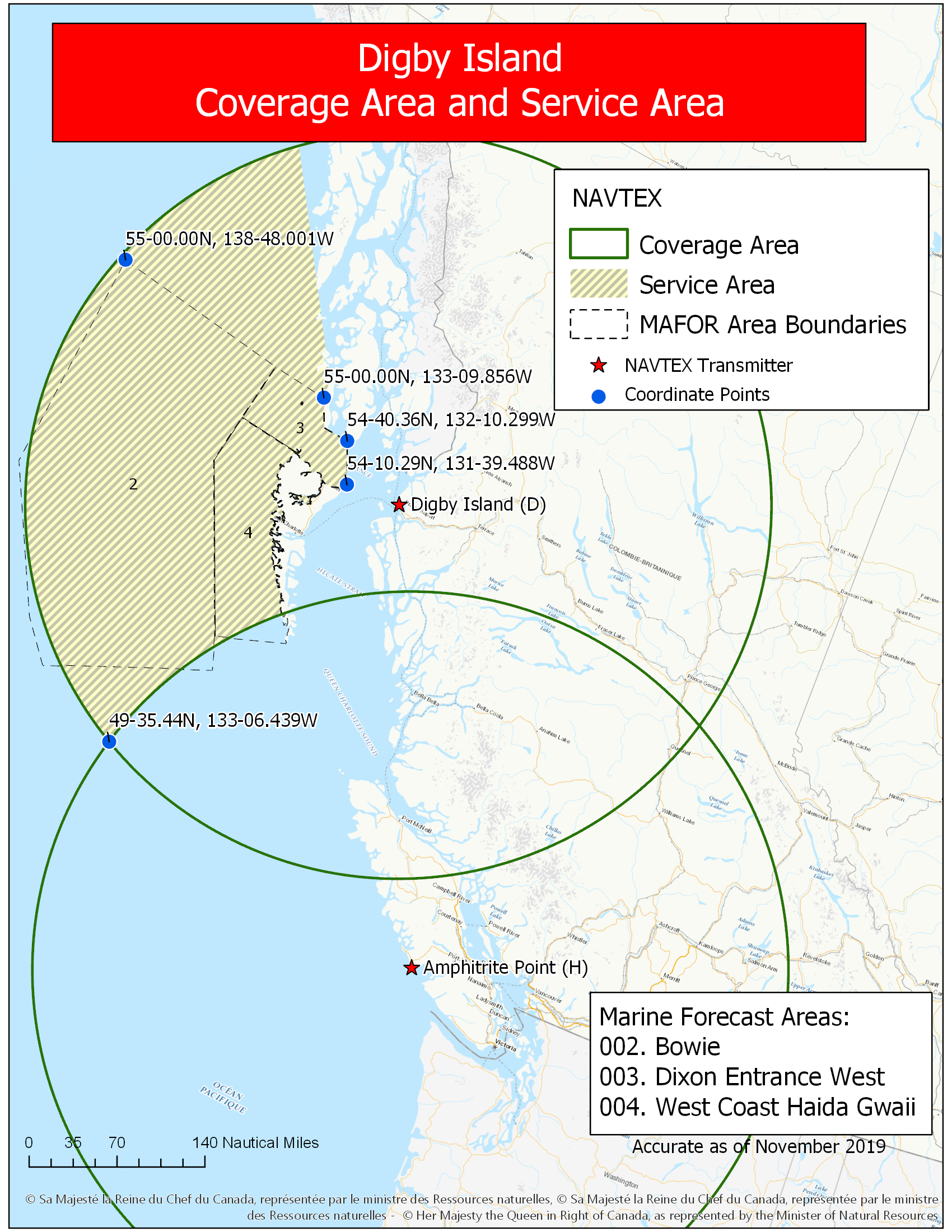
Figure 4-11 b) Amphitrite Point
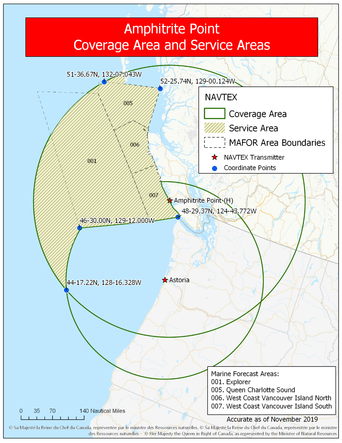
Figure 4-11 c) Pass Lake
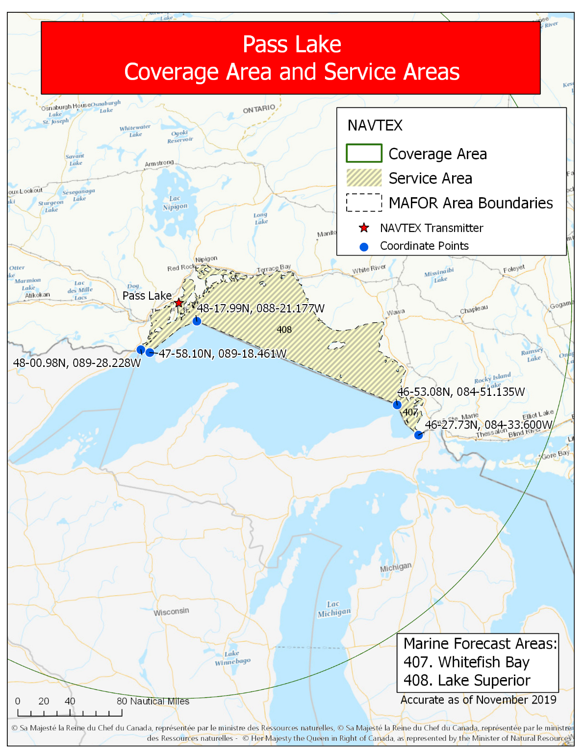
Figure 4-11 d) Ferndale
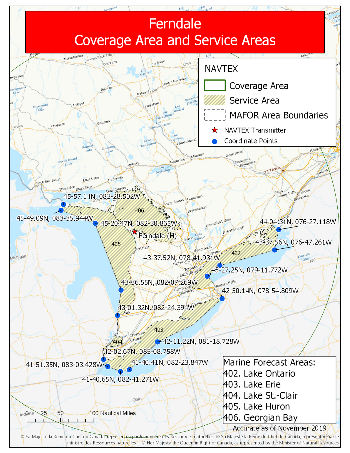
Figure 4-11 e) Moisie
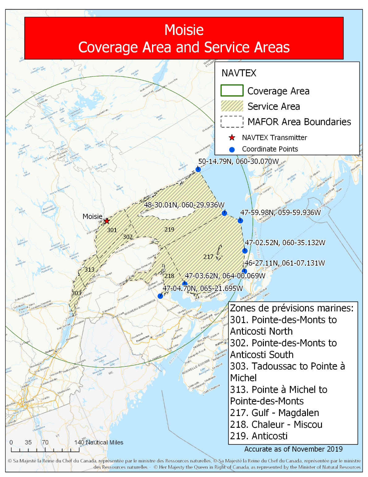
Figure 4-11 f) Chebogue
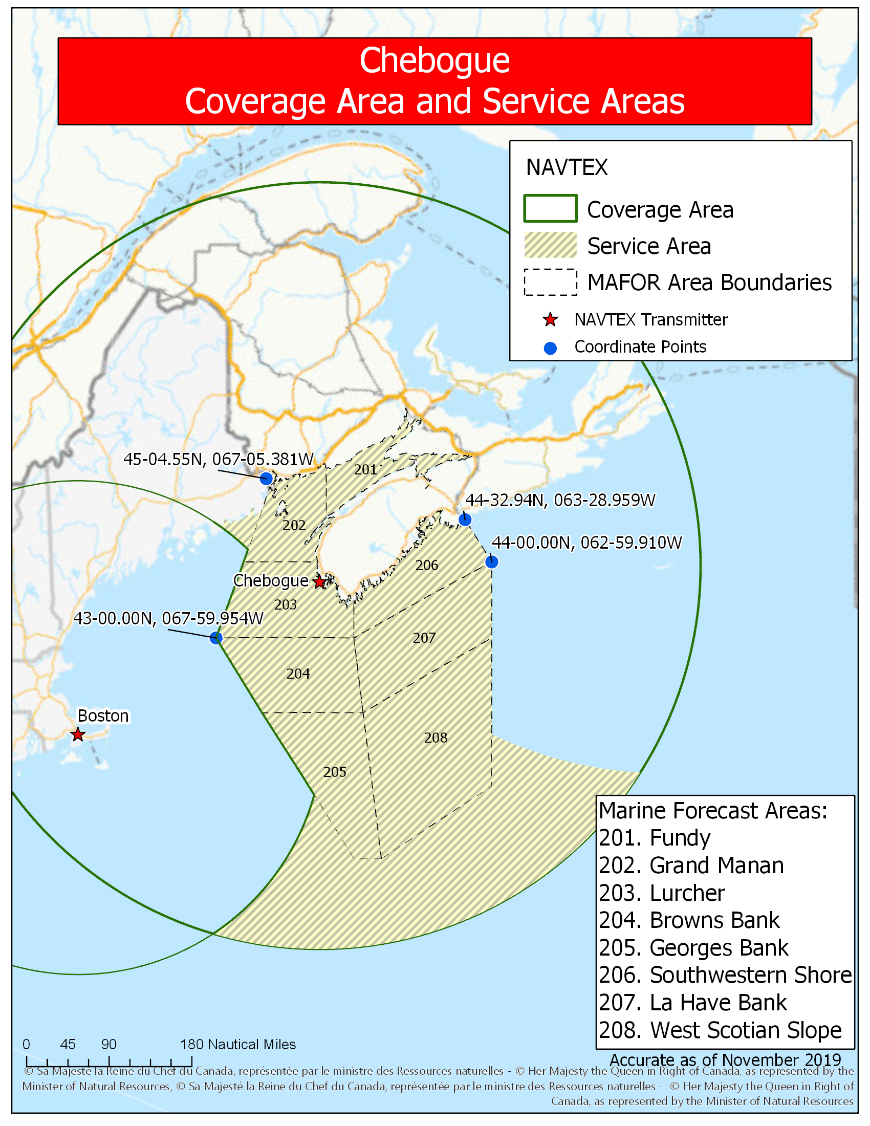
Figure 4-11 g) Port Caledonia
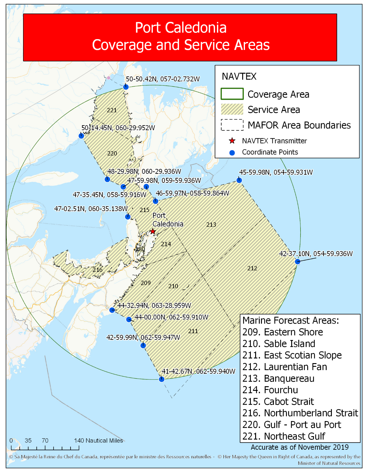
Figure 4-11 h) Robin Hood Bay
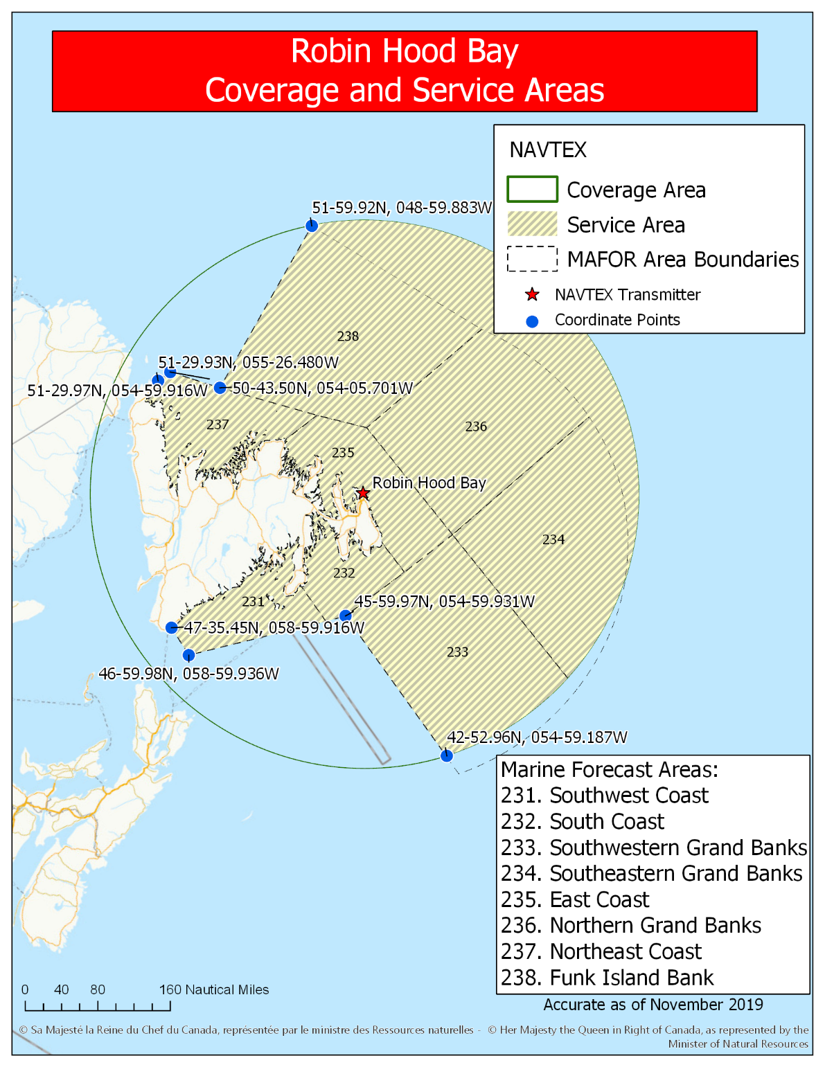
Figure 4-11 i) Cartwright
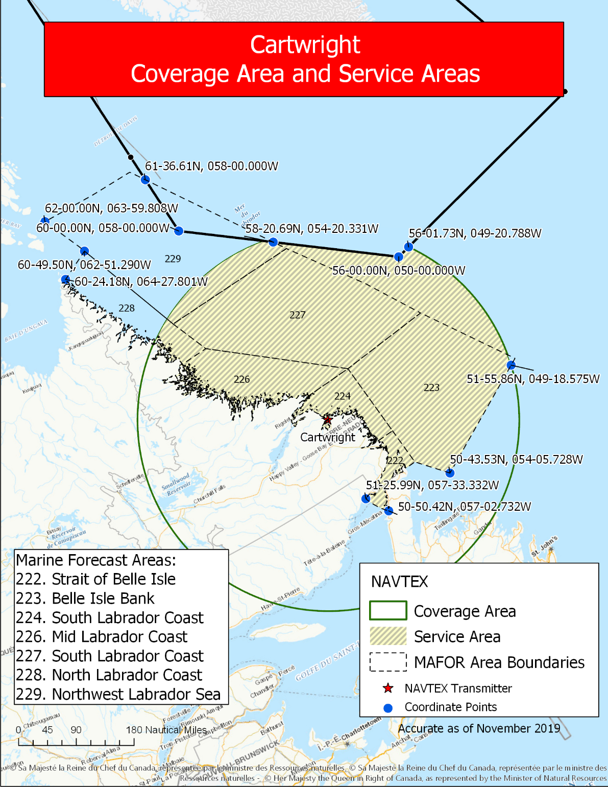
Figure 4-11 j) Iqaluit
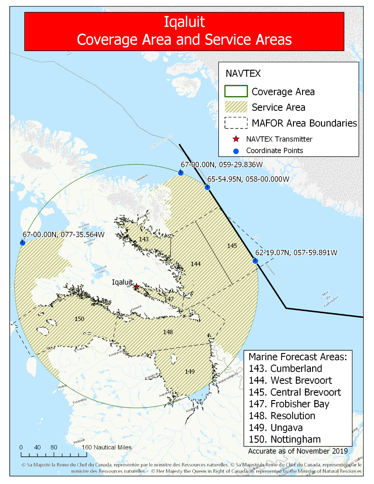
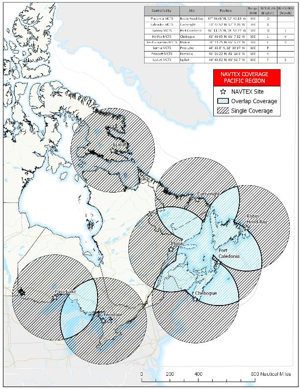
Figure 4-12 Regional NAVTEX Overview - Coverage and Service Areas
Figure 4-12 a) Western Region
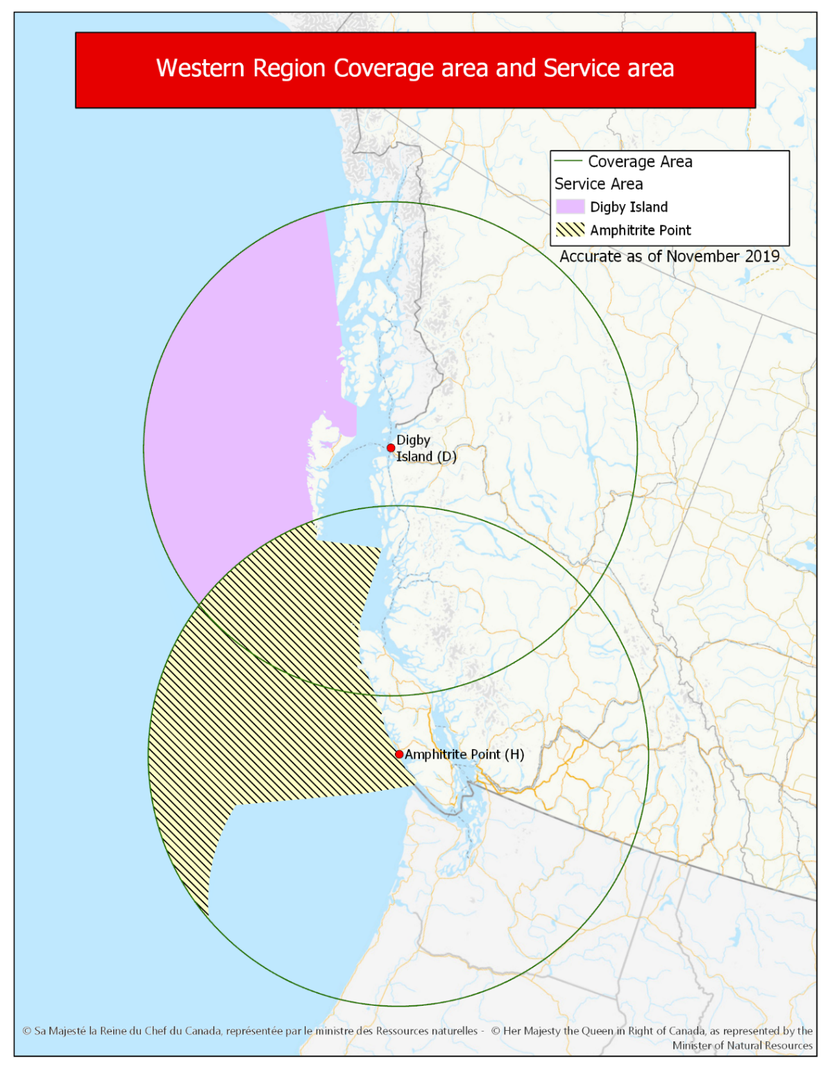
Figure 4-12 b) Great Lakes Region

While the indicated coverage footprint of NAVTEX transmitters located at Pass Lake and Ferndale intersect over Lake Michigan, information specifically pertaining to Lake Michigan waters is not included on NAVTEX broadcasts
Figure 4-12 c) Gulf of St Lawrence and Atlantic Region
Figure 4-12 d) Atlantic Region – Newfoundland and Labrador

Figure 4-12 e) Arctic Region
SECTION 4 - SAILING DIRECTIONS AND SMALL CRAFT GUIDE CORRECTIONS
TABLE OF CONTENTS — CHAPTER 7
Delete: Requisite Channel and Approaches
Replace by: Storis Passage to Requisite Channel
(C2019-017.01)
Chapter 5 — Paragraph 121
Delete: “A depth of 2.7 m … NNE of Cosens
Point.”
(C2019-017.02)
Chapter 7 — Before paragraph 1
Delete: 7725, 7731
Replace by: 7737, 7738
(C2019-017.03)
Chapter 7 — In the vicinity of paragraph 232, photo caption
Delete: HAT ISLAND RADOME FROM EAST OF NORTHPOST ISLAND
(1991)
Replace by: PUTULIK RADOME FROM EAST OF NORTHPOST ISLAND
(1991)
(C2019-017.04)
Chapter 7 — In the vicinity of paragraph 232, photo caption
Delete: HAT ISLAND RADOME FROM SOUTH OF TILLER ISLAND
(1991)
Replace by: PUTULIK RADOME FROM SOUTH OF TILLER ISLAND
(1991)
(C2019-017.05)
Chapter 7 — In the vicinity of paragraph 232, photo caption
Delete: HAT ISLAND LANDING BEACH (1991)
Replace by: PUTULIK LANDING BEACH (1991)
(C2019-017.06)
Chapter 7 — After paragraph 230
Delete: Requisite Channel and Approaches
Replace by: Storis Passage to Requisite Channel
(C2019-017.07)
Chapter 7 — Before paragraph 231
Delete: 7725
Replace by: 7737
(C2019-017.08)
Chapter 7 — Paragraph 232
Delete: Hat Island
Replace by: Putulik
(C2019-017.09)
Chapter 7 — Paragraph 232, after “northward has sighted”
Delete: Hat Island
Replace by: Putulik
(C2019-017.10)
Chapter 7 — Paragraph 233
Delete: Hat Island
Replace by: Putulik
(C2019-017.11)
Chapter 7 — Before paragraph 234
Insert: Chart 7646
(C2019-017.12)
Chapter 7 — Paragraph 234
Delete: Hat Island
Replace by: Putulik
(C2019-017.13)
Chapter 7 — Paragraph 237
Delete: Clog and Hat Islands
Replace by: Clog Island and Putulik
(C2019-017.14)
Chapter 7 — Paragraph 238
Delete: Hat Island
Replace by: Putulik
(C2019-017.15)
Chapter 7 — Paragraph 239, at the beginning of the paragraph
Delete: Hat Island
Replace by: Putulik
(C2019-017.16)
Chapter 7 — Paragraph 239, after “east side of”
Delete: Hat Island
Replace by: Putulik
(C2019-017.17)
Chapter 7 — Paragraph 239
Delete: 3-fathom (5.5-m)
Replace by: 5-m
(C2019-017.18)
Chapter 7 — Paragraphs 242 and 243
Delete: Hat Island
Replace by: Putulik
(C2019-017.19)
Chapter 7 — Before paragraph 244
Insert: Chart 7737
(C2019-017.20)
Chapter 7 — Delete paragraph 250
Replace by:250 Anchorage has been obtained 2 miles SW of Borge Island in about 12.8 m, and 4 miles farther south in about 27.4 m. Anchorage in 27.4 m is also available 2 miles SW of the islet, with the racon, described above.
(C2019-017.21)
Chapter 7 — Paragraphs 251 and 255
Delete: Hat Island
Replace by: Putulik
(C2019-017.22)
Chapter 7 — Delete paragraph 252.
(C2019-017.23)
Chapter 7 — Delete paragraph 259
Replace by:259 Caution. — Numerous shoals and reported shoals lie NW and north of Putulik. Between Grenadier and Leader Islands a shoal with 9.8 m over it and a 1.3-m shoal which breaks, lie close to the track usually followed.
(C2019-017.24)
Chapter 7 — Before paragraph 260
Delete: 7725, 7731
Replace by: 7737, 7738
(C2019-017.25)
Chapter 7 — Before paragraph 262
Delete: 7731
Replace by: 7738
(C2019-017.26)
Chapter 8 — Before paragraph 1
Delete: 7731
Replace by: 7738
(C2019-017.27)
Chapter 8 — After paragraph 21
Delete: 7731
Replace by: 7738
(C2019-017.28)
Chapter 8 — After paragraph 34
Delete: 7646
Replace by: 7736
(C2019-017.29)
Chapter 8 — After paragraph 46
Delete: Chart 7736
(C2019-017.30)
INDEX — After “Haswell Point, C2/P326”
Delete: Hat Island, C7/P232
(C2019-017.31)
INDEX — After “Purchase Bay, C11/P224”
Insert: Putulik, C7/P232
(C2019-017.32)
Chapter 2 — Paragraph 101, after “between Ogden Point and Shoal
Point”
Insert: and has a year-round rescue unit
(P2019-26.1)
Chapter 2 — Adjacent to paragraph 101, add a lifesaving station pictograph.
(P2019-26.2)
Chapter 10 — Paragraph 213
Delete: 2.4 m
Replace by: 1.6 m
(P2019-27.1)
Chapter 2 — Paragraph 91, after “entrance to Bull Harbour”
Insert: and NW of Heath Point
(P2019-24.1)
Chapter 6 — Paragraph 47
Delete: on the east side of Atrevida Point.
Replace by:located between the entrance of Muchalat Inlet and the Houston River.
(P2019-24.2)
INDEX — After “Heater Point, C7/P24”
Insert: Heath Point, C2/P91
(P2019-24.3)
Chapter 1 — Paragraph 268
Delete: 5.2 m
Replace by: 7.4 m
(P2019-22.1)
Chapter 1 — Paragraph 287
Delete: 17 feet (5.2 m)
Replace by: 22 feet (6.7 m)
(P2019-19.1)
Chapter 1 — Paragraph 357
Delete: 17 feet (5.2 m)
Replace by: 21 feet (6.5 m)
(P2019-18.1)
Chapter 1 — Paragraph 378
Delete: daybeacon has a port hand daymark.
Replace by:light (600.6) is shown at an elevation of 4.7 m from a skeleton tower.
(P2019-20.1)
Chapter 1 — Adjacent to paragraph 378, add a light pictograph.
(P2019-20.2)
Chapter 1 — Paragraph 382
Delete: “, 1.3 miles to the east, is marked by a starboard hand
daybeacon.”
Replace by:is 1.3 miles to the east. Fougner Point light (600.8) is shown at an elevation of 10.5 m from a skeleton tower.
(P2019-21.1)
Chapter 1 — Adjacent to paragraph 382, add a light pictograph.
(P2019-21.2)
Chapter 1 — After paragraph 509
Insert:509.1 Johnson Channel (Wallace) light (594.8) is shown at an elevation of 6.1 m from a skeleton tower located 1.7 miles SE of McCroskie Islands. Wallace Point is a local name and not charted.
(P2019-16.1)
Chapter 1 — Adjacent to paragraph 509.1, add a light pictograph.
(P2019-16.2)
Chapter 1 — Paragraph 512
Delete: 6.5 m
Replace by: 7.6 m
(P2019-23.1)
Chapter 1 — After paragraph 517
Insert:517.1 Nicholson (Hoonees) Island light (604.2) is shown at an elevation of 6.7 m from a skeleton tower.
(P2019-17.1)
Chapter 1 — Adjacent to paragraph 517.1, add a light pictograph.
(P2019-17.2)
Chapter 4 — Paragraph 192
Delete: 19 feet (5.9 m)
Replace by: 16 feet (5.0 m)
(P2019-25.1)
INDEX — After “Wallace Bight, C2/P202”
Insert: Wallace Point, C1/P509.1
(P2019-16.3)
SECTION 5 - LIST OF LIGHTS, BUOYS AND FOG SIGNALS CORRECTIONS
The amendments are highlighted and deletions are crossed out. For general and region-specific
information on the List of Lights, click on the following links:
Newfoundland and Labrador Coast,
Atlantic Coast,
Inland Waters and
Pacific Coast.
PACIFIC COAST
| No. | Name |
Position ----- Latitude N. Longitude W. |
Light Characteristics |
Focal Height in m. above water |
Nominal Range |
Description ----- Height in meters above ground |
Remarks ----- Fog Signals |
|||
|---|---|---|---|---|---|---|---|---|---|---|
NORTHERN INSIDE CHANNELS (LL 587 – 718.5) |
||||||||||
|
613 G5708 |
Idol Point |
52 14 18.0 128 16 37.1 |
Fl | W | 6s | 7.6 | 5 |
White square
skeleton tower. 6.6 |
Flash 0.5 s; eclipse 5.5 s. Year round. Chart:3938 Edn 12/19 (P19-104) |
|
PACIFIC COAST (LL 719 – 768.2) |
||||||||||
|
754 G5864 |
Lizard Point |
54 50 00.4 130 16 33.7 |
Fl | W | 6s | 8.6 | 5 | Red cylindrical tower. |
Flash 0.5 s; eclipse 5.5 s. Year round. Chart:3994 Edn 12/19 (P19-135) |
|
CANADIAN COAST GUARD - MARINE INFORMATION REPORT AND SUGGESTION SHEET
Name of Ship or Sender:..................................................................... Date:....................................
Address of Sender:..........................................................................................................................
Street # Street Name
Town / City:.............................. Prov / State:....................... Postal Code / Zip Code: ........................
Tel / Fax / E-mail address of sender (if appropriate):............................................................................
Observation Date:............................................. Time (UTC): ...........................................................
Geographical Position:......................................................................................................................
Coordinate Position: Lat: ............................................... Long:.........................................................
Position Method: DGPS GPS with WAAS GPS Radar Other
Horizontal Datum Used: WGS 84 NAD 27 Other
Estimated Position Accuracy:............................................................................................................
Chart #:............................................................ Datum: NAD 27 NAD 83
Chart Edition:.................................................... Last Correction applied:............................................
Publications affected: (Quote edition and page number):.....................................................................
*Full details (Attach additional sheets as necessary):...........................................................................
Mariners are requested to notify the responsible authorities when new or suspected dangers to navigation are discovered, changes are observed in aids to navigation, or corrections to publications are seen to be necessary.
In the case of new or suspected dangers to navigation, it is important that all details be given in order to aid with future investigations. Items of interest include heights, depths, physical description, type of bottom and equipment method used to position the item. It is helpful to mark details on the chart, which will be promptly replaced by the Canadian Hydrographic Service.
Reports should be made to the nearest Marine Communications and Traffic Services Centre (MCTS) and should be confirmed in writing to:
Leader, Notices to Mariners
Canadian Coast Guard
Department of Fisheries and Oceans
Montréal, QC H2Y 2E7
In the case of information concerning aids to navigation or the List of Lights, Buoys and Fog Signals book.
OR
Director General, Canadian Hydrographic Service & Oceanographic Services
Department of Fisheries and Oceans
Ottawa, ON K1A 0E6
In the case of new or suspected dangers to navigation or where corrections to "Sailing Directions" appear to be necessary.
For general questions on Canadian Coast Guard programs or services, please send an e-mail to:
info@dfo-mpo.gc.ca (Please include your postal code and e-mail address).
You can access the online form on the following page: https://www.notmar.gc.ca/incident-en.php or you can use the printable pdf version : https://www.notmar.gc.ca/publications/monthly-mensuel/images/monthly-form-en.pdf