
Archived information
The Standard on Web Usability replaces this content. This content is archived because Common Look and Feel 2.0 Standards have been rescinded.
Archived information is provided for reference, research or recordkeeping purposes. It is not subject to the Government of Canada Web Standards and has not been altered or updated since it was archived.
NOTICES TO MARINERS
PUBLICATION
WESTERN EDITION

Safety First, Service Always
Published Monthly by the
CANADIAN COAST GUARD
www.notmar.gc.ca/subscribe/
CONTENTS
| Section 1 | General and Safety Information |
| Section 2 | Chart Corrections |
| Section 3 | Radio Aids to Marine Navigation Corrections |
| Section 4 | Sailing Directions and Small Craft Guide Corrections |
| Section 5 | List of Lights, Buoys and Fog Signals Corrections |
Canadian Coast Guard Programs
Aids to Navigation and Waterways
Fisheries and Oceans Canada
Montreal, Quebec
H2Y 2E7
© Her Majesty the Queen in Right of Canada, 2019
DFO/2019-2026
Fs152-6E-PDF
ISSN 1719-7708
Disponible en français :
Publication des Avis aux navigateurs
Édition de l'Ouest
Édition mensuelle Nº02/2019
Fisheries and Oceans Canada
Official Publication of the Canadian Coast Guard
DFO/2019-2026
EXPLANATORY NOTES
Geographical positions refer directly to the graduations of the largest scale Canadian Hydrographic chart unless otherwise indicated.
Bearings refer to the true compass and are measured clockwise from 000° (North) clockwise to 359°; those relating to lights are from seaward.
Visibility of lights is that in clear weather.
Depths - The units used for soundings (metres, fathoms or feet) are stated in the title of each chart.
Elevations are normally given above Higher High Water, Large Tide unless otherwise indicated.
Distances may be calculated as follows:
1 nautical mile = 1,852 metres (6,076.1 feet)
1 statute mile = 1,609.3 metres (5,280 feet)
1 metre = 3.28 feet
Temporary & Preliminary Notices are indicated by a (T) or a (P) in Section 1, respectively. Please note that Nautical charts are not amended by the Canadian Hydrographic Service for Temporary (T) and Preliminary (P) Notices. It is recommended that mariners chart these corrections in pencil. The list of charts affected by Temporary and Preliminary Notices are revised and promulgated quarterly in Section 1 of the Monthly Edition.
Please note that, in addition to the temporary and preliminary changes normally advertised as (T) and (P) Notices, there are a few permanent changes to aids to navigation that have been advertised as Preliminary Notices to Mariners while charts are being updated for new editions.
Marine Information Report & Suggestion Sheet
Mariners are requested to notify the responsible authorities when new or suspected dangers to navigation are discovered, changes observed in aids to navigation or corrections to publications are seen
to be necessary. Such communications can be made using the Marine Information Report & Suggestion Sheet inserted on the last
page of each monthly edition of Notices to Mariners.
Canadian Hydrographic Service - Information Published in Section 2 of Notices to Mariners
Mariners are advised that only the most critical changes that directly affect safety to navigation are issued in Section 2 – Chart Corrections. This limitation
is required to ensure that charts remain as clear and easy to read as possible. As a result, mariners may see minor discrepancies of a
non-critical nature between information in official publications. For example, a small change in the nominal range or focal height of a light
may not result in the production of a chart correction in Notices to Mariners, but may result in a correction in the List of Lights, Buoys and
Fog Signals publication.
In case of discrepancy between information provided on CHS charts relating to aids to navigation, and the List of Lights, Buoys and Fog Signals publication, the latter shall be deemed as containing the most up-to-date information.
Canadian Nautical Charts & Publications
A source list of Canadian nautical charts and publications is published in Notice No. 14 of the Notices to Mariners Annual Edition 2018. The source supply and the prices
effective at the time of printing are listed. For current chart edition dates, please refer to the following website:
www.chs-shc.gc.ca/charts-cartes/paper-papier/index-eng.asp
CHART CORRECTIONS - SECTION 2
Corrections to nautical charts will be listed in numerical order by chart number. Each chart correction listed applies only to that particular chart. Related charts, if any, will have their own specific correction listed separately.
Users should also refer to CHS Chart 1: Symbols, Abbreviations and Terms for additional information pertaining to the correction of charts.
The illustration below describes the elements that will comprise a typical Section 2 chart correction:

The last correction number is identified with the LNM/D or Last Notice to Mariners Number / Date.
NOTICES TO MARINERS WEBSITE – MONTHLY EDITIONS, CHART CORRECTIONS, AND CHART PATCHES
The Notices to Mariners website allows users to access the monthly publications,
chart corrections, and chart patches.
Users can subscribe for free to the email notification service
to receive notifications when charts of interest are updated, including their patches, as well as when a new monthly edition becomes available online.
ADVISORY NAVIGATIONAL WARNINGS / NOTICES TO SHIPPING
The Canadian Coast Guard is implementing a number of changes to the aids to navigation system in Canada.
These changes are advertised as Navigational Warnings, formerly called Notices to ShippingFootnote 1, that are broadcast by the Canadian Coast Guard, and are then followed up with Notices to Mariners, then charts are updated by hand correction, reprints or new editions.
Mariners are advised that all relevant Navigational Warnings (NAVWARNs) should be kept until superseded by Notices to Mariners or through revised charts issued by the Canadian Hydrographic Service (CHS).
Navigational Warnings are accessible on the applicable regional page on the Canadian Coast Guard e-Navigation Maritime Information Portal at http://www.marinfo.gc.ca/e-nav.
The Canadian Hydrographic Service is reviewing the impact of these changes with the Canadian Coast Guard and together are preparing an action plan on the issuing of chart revisions.
For further information, contact your regional Navigational Warning (NAVWARN) Issuing Desk.
Western Region
Prince Rupert MCTS Centre
Canadian Coast Guard
Bag 4444
Prince Rupert, BC V8J 4K2
Telephone: (250) 627-3070
Email: NAVWARN.MCTSPrinceRupert@innav.gc.ca
Website: http://www.marinfo.gc.ca/e-nav
Central & Arctic Region
* Iqaluit MCTS Centre
Operational from approximately mid-May until late December.
Canadian Coast Guard
P.O. Box 189
Iqaluit, NU X0A 0H0
“A” Series
Telephone: (867) 979-5269
“H” Series
Telephone: (867) 979-0310
Facsimile: (867) 979-4264
Email: NAVWARN.MCTSIqaluit@innav.gc.ca
Website: http://www.marinfo.gc.ca/e-nav
* Service available in English and French.
Index
NUMERICAL INDEX OF CANADIAN CHARTS AFFECTED
| 3001 | 3489 | 3646 | 3935 |
| 3311 | 3512 | 3671 | 3945 |
| 3410 | 3513 | 3681 | 3947 |
| 3463 | 3514 | 3890 | 6242 |
| 3475 | 3526 | 3894 | 6417 |
| 3481 | 3548 | 3934 |
SECTION 1 - GENERAL AND SAFETY INFORMATION
CANADIAN HYDROGRAPHIC SERVICE – ANNOUNCEMENT REGARDING CHS CHART PATCHES
Colour Web Patches are free to the mariner, and given the quality of many printers, should reproduce well. They will be available in real time all around the world.
CHS welcomes your feedback on this service at chsinfo@dfo-mpo.gc.ca
CANADIAN HYDROGRAPHIC SERVICE – CUMULATIVE CHART CORRECTIONS
The cumulative chart corrections published in
Notices to Mariners can now be accessed
at
https://www.notmar.gc.ca/corrections-en.php
CANADIAN HYDROGRAPHIC SERVICE – CURRENT CHART EDITION DATES
CHART
EDITIONS
The three terms
described below are used to indicate the publication status
of Canadian charts.
NEW CHART -
"NEWCHT"
The first
publication of a Canadian chart embracing an area not
previously charted to the scale shown, or embracing an area
different from any existing Canadian chart.
NEW EDITION -
"NEWEDT"
A new issue of
an existing chart containing amendments essential to
navigation in addition to those issued in Notices
to Mariners and making existing editions
obsolete.
REPRINTS
A new
issue of the current edition of a chart incorporating no
amendments of navigational significance other than those
previously promulgated in Notices to
Mariners. It may also contain amendments from
other sources provided they are not essential to navigation.
Previous printings of the current edition remain in
force.
The current chart edition dates can be accessed at www.chs-shc.gc.ca/charts-cartes/paper-papier/index-eng.asp
CANADIAN HYDROGRAPHIC SERVICE – PRINT ON DEMAND CHARTS - CARE AND USE
Background
By providing nautical charts to the public, the goal of the Canadian Hydrographic Service (CHS) is to provide services for safe navigation in a fiscally responsible manner. As a result, CHS continues to expand its portfolio of nautical paper charts that are printed using Print On Demand (POD) technology. These charts are easily recognized by their whiter paper and the coloured logo of the Canadian Hydrographic Service. This new technology enables CHS to print charts in a more efficient manner, while enhancing chart content through being able to quickly add new and important information. POD technology provides customers with up-to-date charts without the historical hand-drawn corrections or glued-on patches. Additionally, this technology eliminates out-of-stock situations which arise with the traditional printing and warehousing methods. In the event of a national emergency, CHS can respond to the appropriate authorities with the best available information very quickly.
Care of Your POD Chart
CHS encourages its customers to handle the POD charts more carefully than the traditional lithographic charts. When plotting information on POD charts, use HB pencils and apply limited pressure. Testing has suggested that an Indian gum eraser is more effective than alternatives when used on the product. This eraser is also suitable for charts printed using lithographic processes.
CANADIAN HYDROGRAPHIC SERVICE, TRANSPORT CANADA – NAVIGATION SAFETY - ECDIS
Mariners are advised that ECDIS may not display some isolated shoal depths when operating in "base or standard display" mode. Route planning and monitoring alarms for these shoal depths may not always be activated. To ensure safe navigation and to confirm that a planned route is clear of such dangers, mariners should visually inspect the planned route and any deviations from it using ECDIS configured to display "all data". The automated voyage planning check function should not be solely relied upon.
NOTICES TO MARINERS WEBSITE – MONTHLY PUBLICATION AND RELATED FILES TO DOWNLOAD NOW AVAILABLE IN A SINGLE ZIP FILE
The Notices to Mariners website has now added a new functionality where the monthly publication and related files to download, such as chart patches and Sailing Directions diagrams, can be obtained all together through the download of a single ZIP file.
The NOTMAR team would appreciate any feedback concerning this new functionality by sending an email to Notmar.XNCR@dfo-mpo.gc.ca.
*201 CANADIAN HYDROGRAPHIC SERVICE – NAUTICAL CHARTS
|
CHARTS |
MAIN TITLE |
SCALE |
PUBLISHED |
CAT# |
PRICE |
|---|---|---|---|---|---|
|
New Editions |
|||||
|
CAT-3 |
Catalogue of Nautical Charts and Publications -
Ontario/Manitoba Including the Great Lakes
/ |
25-JAN-2019 |
N/A |
0.00 |
|
|
CAT-4 |
Catalogue of Nautical Charts and Publications - Arctic / Catalogue des Cartes et publications nautiques - Arctique |
25-JAN-2019 |
N/A |
0.00 |
*202 CANADIAN HYDROGRAPHIC SERVICE – ELECTRONIC NAVIGATIONAL CHARTS
|
S-57 ENC NUMBER |
CHART TITLE |
|---|---|
|
WITHDRAWN PRODUCTS |
|
|
CA576096 |
International Piers |
|
CA576097 |
North Sydney |
|
CA576098 |
Sydney River |
|
CA576099 |
Sydney Wharves/Quais |
|
CA576100 |
Sydport |
|
CA576305 |
Channel Port Aux Basques |
|
CA576420 |
St. Anthony Harbour |
*203 CANADIAN HYDROGRAPHIC SERVICE – RASTER DIGITAL CHARTS (BSB V3)
|
CHARTS |
MAIN TITLE |
SCALE |
PUBLISHED |
|---|---|---|---|
|
New Editions |
|||
|
RM-1430 |
Lac Saint-Louis |
1:25 000 |
23-NOV-2018 |
|
RM-2314 |
Port of Thunder Bay |
1:20 000 |
02-NOV-2018 |
|
RM-3891 |
Skidegate Channel |
1:40 000 |
26-OCT-2018 |
|
RM-4203 |
Halifax Harbour: Black Point to / à Point Pleasant |
1:10 000 |
28-DEC-2018 |
|
RM-4920 |
Plans Baie des Chaleurs / Chaleur Bay - Côte sud / South Shore |
1:20 000 |
14-DEC-2018 |
|
RM-5625 |
Schooner Harbour to/à Baker Lake |
1:40 000 |
28-DEC-2018 |
|
RM-7150 |
Pangnirtung and Approaches/et les approches |
1:40 000 |
02-NOV-2018 |
|
Charts Permanently Withdrawn |
|||
|
RM-4437 |
Pictou Harbour |
||
|
RM-4443 |
East River of Pictou: Indian Cross Point to / à Trenton and New Glasgow |
||
*205 BARKLEY SOUND – STRUCTURE FOR A DAYBEACON REBUILT AND REPOSITIONED
Reference Chart: 3671
The structure of the following daybeacon has been rebuilt and respositioned to the following coordinates:
Cia Rock port daybeacon (LL 5078.1): 48° 50’ 16.9”N 125° 10’ 57.6”W
(P2019-004)
*206 PLANS - QUATSINO SOUND – FRONT RANGE REBUILT AND REPOSITIONED
Reference Chart: 3681
The following front range has been rebuilt and respositioned to the following coordinates:
Quatsino Narrows front range (LL 5006): 50° 32’ 50.5”N 127° 33’ 34.9”W
(P2018-142)
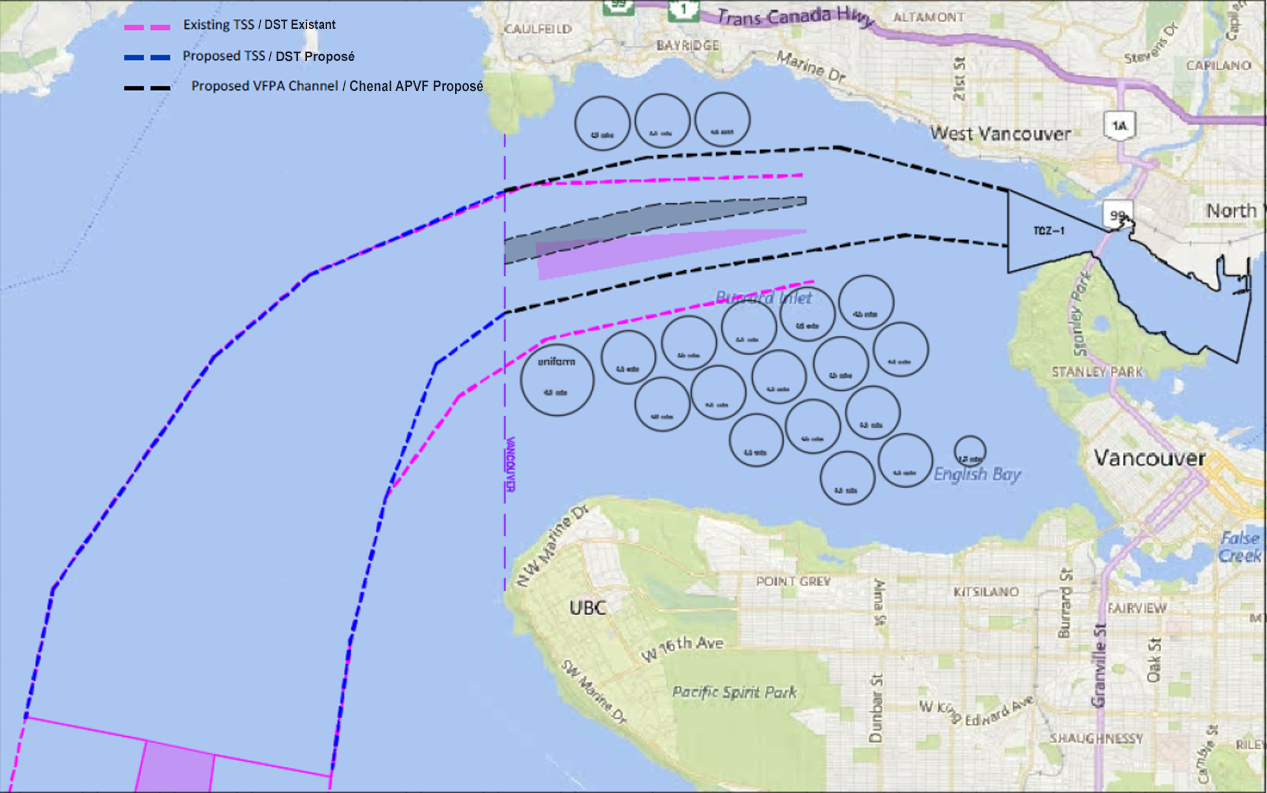
*209(P) VANCOUVER FRASER PORT AUTHORITY – NEW TRAFFIC SEPARATION SCHEME TO BE IMPLEMENTED FOR APPROACHES TO VANCOUVER HARBOUR
Reference Charts: 3463 & 3481
Vancouver Fraser Port Authority (VFPA) is implementing a new traffic separation scheme (TSS) for the approaches to Vancouver Harbour, which will come into effect on May 1, 2019. These changes are primarily affecting charts Strait of Georgia, Southern Portion/Partie Sud (Chart 3463) and Approaches to/Approches à Vancouver Harbour (Chart 3481). For more details, please refer to the graphic below.
*210 WINNIPEG TO/AU LAKE WINNIPEG/LAC WINNIPEG – AIDS TO NAVIGATION PERMANENTLY DISCONTINUED
Reference: Notice 417(P)/18 is cancelled (Chart 6242).
(A2018-051, 053, 055, 056)
*211 PLANS - BARKLEY SOUND – DAYBEACON PERMANENTLY DISCONTINUED
Reference: Notice 611(P)/18 is cancelled (Chart 3646).
(P2018-141)
SECTION 2 - CHART CORRECTIONS
3001 - Vancouver Island / Île de Vancouver, Juan de Fuca Strait to/à Queen Charlotte Sound - New Edition - 23-FEB-2001 - NAD 1927
| 15-FEB-2019 | LNM/D. 28-SEP-2018 | ||
| Delete |
depth of 1788 fathoms (See Chart No. 1, I10) This notice affects Electronic Navigational Chart: CA270389 |
50°07′24.9″N 129°35′59.0″W | |
| DFO(6203950-01) | |||
| Add |
depth of 859 fathoms (See Chart No. 1, I10) This notice affects Electronic Navigational Chart: CA270389 |
50°07′27.4″N 129°35′38.9″W | |
| DFO(6203950-02) | |||
| Delete |
depth of 307 fathoms (See Chart No. 1, I10) This notice affects Electronic Navigational Chart: CA270389 |
48°45′29.4″N 127°09′17.2″W | |
| DFO(6203950-03) | |||
| Delete |
depth of 379 fathoms (See Chart No. 1, I10) This notice affects Electronic Navigational Chart: CA270389 |
48°44′23.6″N 126°56′14.7″W | |
| DFO(6203950-04) | |||
| Delete |
depth of 312 fathoms (See Chart No. 1, I10) This notice affects Electronic Navigational Chart: CA270389 |
48°43′59.7″N 126°47′13.9″W | |
| DFO(6203950-05) | |||
| Delete |
depth of 222 fathoms (See Chart No. 1, I10) This notice affects Electronic Navigational Chart: CA270389 |
48°43′25.6″N 126°40′40.3″W | |
| DFO(6203950-06) | |||
| Add |
depth of 694 fathoms (See Chart No. 1, I10) This notice affects Electronic Navigational Chart: CA270389 |
48°43′24.0″N 126°40′41.8″W | |
| DFO(6203950-07) | |||
| Add |
depth of 1108 fathoms (See Chart No. 1, I10) This notice affects Electronic Navigational Chart: CA270389 |
48°45′29.0″N 127°09′20.3″W | |
| DFO(6203950-08) | |||
| Add |
depth of 735 fathoms (See Chart No. 1, I10) This notice affects Electronic Navigational Chart: CA270389 |
48°43′59.2″N 126°47′14.3″W | |
| DFO(6203950-09) | |||
| Add |
depth of 792 fathoms (See Chart No. 1, I10) This notice affects Electronic Navigational Chart: CA270389 |
48°44′23.8″N 126°56′14.3″W | |
| DFO(6203950-10) |
3311 - Port Moody to/à Howe Sound - Sheet/Feuille 1 - New Edition - 31-DEC-1993 - NAD 1983
| 22-FEB-2019 | LNM/D. 14-DEC-2018 | ||
| Add |
submarine cable (See Chart No. 1, L30.1) This notice affects Electronic Navigational Chart: CA370016, CA370381, CA370382, CA470004 |
joining 49°20′36.4″N 123°25′44.2″W 49°20′38.4″N 123°25′54.4″W 49°20′34.1″N 123°27′22.3″W 49°20′28.6″N 123°28′07.9″W 49°20′34.4″N 123°29′13.5″W 49°20′52.8″N 123°30′59.8″W 49°21′16.4″N 123°31′58.7″W and 49°23′00.0″N 123°37′53.3″W |
|
| DFO(6203983-01) |
3311 - Howe Sound to/à Pender Harbour - Sheet/Feuille 3 - New Edition - 31-DEC-1993 - NAD 1983
| 22-FEB-2019 | LNM/D. 14-DEC-2018 | ||
| Add |
submarine cable (See Chart No. 1, L30.1) This notice affects Electronic Navigational Chart: CA370016, CA370381, CA370382, CA470004 |
joining 49°20′36.4″N 123°25′44.2″W 49°20′38.4″N 123°25′54.4″W 49°20′34.1″N 123°27′22.3″W 49°20′28.6″N 123°28′07.9″W 49°20′34.4″N 123°29′13.5″W 49°20′52.8″N 123°30′59.8″W 49°21′16.4″N 123°31′58.7″W 49°24′39.7″N 123°44′00.9″W 49°25′57.3″N 123°46′53.1″W 49°26′13.0″N 123°49′17.7″W and 49°25′20.9″N 123°54′50.3″W |
|
| DFO(6203983-01) |
3410 - Pedder Bay - New Edition - 17-MAY-2013 - World Geodetic System 1984
| 08-FEB-2019 | LNM/D. 12-SEP-2014 | ||
| Reposition |
green port hand pillar buoy, marked V11 (See Chart No. 1, Qg) This notice affects Electronic Navigational Chart: CA570101 |
from 48°20′31.3″N 123°33′28.7″W to 48°20′31.1″N 123°33′28.2″W |
|
| (P2018137) DFO(6203943-01) |
3463 - Strait of Georgia, Southern Portion/Partie Sud - New Edition - 01-JUL-2005 - NAD 1983
| 22-FEB-2019 | LNM/D. 19-OCT-2018 | ||
| Add |
SILTING Mariners are advised that depths shown in the vicinity of Boundary Bay are subject to change as a result of silting. ENVASEMENT Les navigateurs prendront garde que les profondeurs cartographiées à proximité de Boundary Bay peuvent changer en raison de l′ensablement. This notice affects Electronic Navigational Chart: CA370145 |
49°03′15.0″N 122°58′00.0″W | |
| DFO(6203975-01) | |||
| Add |
submarine cable (See Chart No. 1, L30.1) This notice affects Electronic Navigational Chart: CA370016, CA370381, CA370382, CA470004 |
joining 49°20′36.4″N 123°25′44.2″W 49°20′38.4″N 123°25′54.4″W 49°20′34.1″N 123°27′22.3″W 49°20′28.6″N 123°28′07.9″W 49°20′34.4″N 123°29′13.5″W 49°20′52.8″N 123°30′59.8″W 49°21′16.4″N 123°31′58.7″W and 49°22′00.0″N 123°34′23.7″W |
|
| DFO(6203983-01) |
3475 - Dodd Narrows to/à Flat Top Islands - New Edition - 30-DEC-2005 - NAD 1983
| 08-FEB-2019 | LNM/D. 29-JUN-2018 | ||
| Add |
pile (See Chart No. 1, F22) This notice affects Electronic Navigational Chart: CA570156 |
49°08′22.0″N 123°51′07.4″W | |
| DFO(6203946-01) | |||
| Add |
pile (See Chart No. 1, F22) This notice affects Electronic Navigational Chart: CA570156 |
49°08′22.0″N 123°51′06.2″W | |
| DFO(6203946-02) | |||
| Add |
breakwater (See Chart No. 1, F4.1) This notice affects Electronic Navigational Chart: CA570156 |
between 49°08′22.9″N 123°51′04.9″W and 49°08′19.0″N 123°51′06.2″W |
|
| DFO(6203946-03) |
3489 - Pattullo Bridge to/à Barnston Island - Sheet/Feuille 1 - New Chart - 21-OCT-1994 - NAD 1983
| 22-FEB-2019 | LNM/D. 06-APR-2018 | ||
| Affix |
patch Download Patch - ftp://ftp.dfo-mpo.gc.ca/patches/3489A Patch_NTM20190222.pdf |
49°11′37.0″N 122°41′00.0″W | |
| DFO(6203987-01) |
3489 - Barnston Island to/à Crescent Island - Sheet/Feuille 2 - New Chart - 21-OCT-1994 - NAD 1983
| 22-FEB-2019 | LNM/D. 06-APR-2018 | ||
| Affix |
patch Download Patch - ftp://ftp.dfo-mpo.gc.ca/patches/3489B Patch_NTM20190222.pdf |
49°12′00.0″N 122°40′00.0″W | |
| DFO(6203987-02) |
3512 - Strait of Georgia, Central Portion/Partie Centrale - New Edition - 25-DEC-1998 - NAD 1983
| 22-FEB-2019 | LNM/D. 30-NOV-2018 | ||
| Add |
rock awash at chart datum (See Chart No. 1, K12) This notice affects Electronic Navigational Chart: CA370381, CA470095 |
49°45′44.1″N 123°57′00.0″W | |
| DFO(6203964-03) | |||
| Add |
submarine cable (See Chart No. 1, L30.1) This notice affects Electronic Navigational Chart: CA370016, CA370381, CA370382, CA470004 |
joining 49°20′36.4″N 123°25′44.2″W 49°20′38.4″N 123°25′54.4″W 49°20′34.1″N 123°27′22.3″W 49°20′28.6″N 123°28′07.9″W 49°20′34.4″N 123°29′13.5″W 49°20′52.8″N 123°30′59.8″W 49°21′16.4″N 123°31′58.7″W 49°24′39.7″N 123°44′00.9″W 49°25′57.3″N 123°46′53.1″W 49°26′13.0″N 123°49′17.7″W 49°25′16.2″N 123°55′18.0″W 49°23′40.5″N 124°07′10.7″W 49°23′16.2″N 124°08′57.8″W 49°22′57.4″N 124°09′36.9″W 49°20′40.8″N 124°17′00.8″W 49°20′39.6″N 124°18′06.3″W 49°21′00.7″N 124°20′14.0″W 49°20′55.8″N 124°20′43.9″W and 49°20′37.5″N 124°21′11.7″W |
|
| DFO(6203983-01) |
3513 - Strait of Georgia, Northern Portion/Partie Nord - New Edition - 29-OCT-1999 - NAD 1983
| 22-FEB-2019 | LNM/D. 14-DEC-2018 | ||
| Add |
submarine cable (See Chart No. 1, L30.1) This notice affects Electronic Navigational Chart: CA370016, CA370381, CA370382, CA470004 |
between 49°20′39.0″N 124°21′11.0″W and 49°20′56.9″N 124°20′41.2″W |
|
| DFO(6203983-01) |
3514 - Jervis Inlet - New Edition - 02-AUG-1996 - NAD 1983
| 22-FEB-2019 | LNM/D. 17-AUG-2018 | ||
| Delete |
depth of 5.5 metres (See Chart No. 1, I10) This notice affects Electronic Navigational Chart: CA470095 |
49°45′44.9″N 123°57′02.6″W | |
| DFO(6203964-01) | |||
| Add |
rock which covers and uncovers with drying height of 0.6
metres (See Chart No. 1, K11) This notice affects Electronic Navigational Chart: CA470095 |
49°45′01.3″N 123°53′56.6″W | |
| DFO(6203964-02) | |||
| Add |
rock awash at chart datum (See Chart No. 1, K12) This notice affects Electronic Navigational Chart: CA370381, CA470095 |
49°45′44.1″N 123°57′00.0″W | |
| DFO(6203964-03) | |||
| Add |
rock which covers and uncovers with drying height of 0.5
metres (See Chart No. 1, K11) This notice affects Electronic Navigational Chart: CA470095 |
49°44′51.4″N 123°54′59.0″W | |
| DFO(6203964-04) | |||
| Add |
depth of 1.5 metres (See Chart No. 1, I10) This notice affects Electronic Navigational Chart: CA470095 |
49°45′32.2″N 123°55′23.5″W | |
| DFO(6203964-05) | |||
| Add |
depth of 4.2 metres (See Chart No. 1, I10) This notice affects Electronic Navigational Chart: CA470095 |
49°45′45.6″N 123°56′38.9″W | |
| DFO(6203964-06) |
3514 - Sechelt Rapids - New Edition - 02-AUG-1996 - NAD 1983
| 22-FEB-2019 | LNM/D. 17-AUG-2018 | ||
| Affix |
patch Download Patch - ftp://ftp.dfo-mpo.gc.ca/patches/3514 Patch_NTM20190222.pdf This notice affects Electronic Navigational Chart: CA570097 |
49°44′00.0″N 123°53′00.0″W | |
| DFO(6203964-07) |
3526 - Howe Sound - New Edition - 01-JUL-2005 - NAD 1983
| 22-FEB-2019 | LNM/D. 07-JUL-2017 | ||
| Add |
submarine cable (See Chart No. 1, L30.1) This notice affects Electronic Navigational Chart: CA370016, CA370381, CA370382, CA470004 |
joining 49°20′36.4″N 123°25′44.2″W 49°20′38.4″N 123°25′54.4″W 49°20′34.1″N 123°27′22.3″W 49°20′28.6″N 123°28′07.9″W 49°20′34.4″N 123°29′13.5″W 49°20′52.8″N 123°30′59.8″W 49°21′16.4″N 123°31′58.7″W and 49°21′32.2″N 123°32′52.8″W |
|
| DFO(6203983-01) |
3548 - Port Hardy - New Edition - 26-SEP-1997 - NAD 1983
| 22-FEB-2019 | LNM/D. 24-AUG-2018 | ||
| Affix |
patch Download Patch - ftp://ftp.dfo-mpo.gc.ca/patches/3548 Patch_NTM20190222.pdf This notice affects Electronic Navigational Chart: CA570033 |
50°43′00.0″N 127°29′00.0″W | |
| DFO(6203959-01) |
3646 - Bamfield Inlet - New Edition - 30-JUN-1995 - NAD 1983
| 15-FEB-2019 | LNM/D. 05-OCT-2018 | ||
| Delete |
starboard hand daybeacon (See Chart No. 1, Qt) |
48°49′43.3″N 125°08′22.1″W | |
| (P2018141) DFO(6203956-01) | |||
| Add |
drying height of 0.8 metres (See Chart No. 1, I15) This notice affects Electronic Navigational Chart: CA570227 |
48°49′42.9″N 125°08′21.9″W | |
| DFO(6203956-02) |
3890 - Alliford Bay - New Chart - 14-MAR-1986 - NAD 1927
| 01-FEB-2019 | LNM/D. 28-SEP-2018 | ||
| Amend |
Fl to read Fl 6s against light (See Chart No. 1, P1) |
53°12′56.7″N 131°59′27.9″W | |
| LL(782) DFO(6203940-01) |
3894 - Selwyn Inlet to/à Lawn Point - New Edition - 12-JUN-1998 - NAD 1983
| 01-FEB-2019 | LNM/D. 28-SEP-2018 | ||
| Amend |
Fl to read Fl 6s against light (See Chart No. 1, P1) |
53°12′55.8″N 131°59′34.1″W | |
| LL(782) DFO(6203940-01) |
3934 - Approaches to/Approches à Smith Sound and/et Rivers Inlet - New Chart - 21-FEB-1992 - NAD 1983
| 22-FEB-2019 | LNM/D. 23-NOV-2018 | ||
| Amend |
Fl to read Fl 6s against light (See Chart No. 1, P1) |
51°25′27.5″N 127°42′01.5″W | |
| LL(583) DFO(6203984-01) |
3935 - Hakai Passage and Vicinity/et Environs - New Chart - 28-JAN-2000 - NAD 1983
| 15-FEB-2019 | LNM/D. 09-NOV-2018 | ||
| Add |
yellow ODAS/SADO lighted pillar buoy Fl(5) Y20s, marked
Priv (See Chart No. 1, Q58) This notice affects Electronic Navigational Chart: CA470358 |
51°39′10.1″N 128°05′13.0″W | |
| DFO(6203958-01) |
3945 - Coghlan Anchorage - New Chart - 25-DEC-2009 - NAD 1983
| 08-FEB-2019 | LNM/D. 26-OCT-2018 | ||
| Add |
rock which covers and uncovers with drying height of 1.1
metres (See Chart No. 1, K11) This notice affects Electronic Navigational Chart: CA570592 |
53°25′25.4″N 129°14′14.6″W | |
| DFO(6203952-01) | |||
| Delete |
depth of 0.4 metres (See Chart No. 1, I10) This notice affects Electronic Navigational Chart: CA570592 |
53°25′25.3″N 129°14′14.7″W | |
| DFO(6203952-02) |
3947 - Grenville Channel to/à Chatham Sound - New Chart - 25-DEC-2009 - NAD 1983
| 08-FEB-2019 | LNM/D. 26-OCT-2018 | ||
| Reposition |
ON CERTAIN COPIES rock which covers and uncovers with drying height of 0.4 metres (See Chart No. 1, K11) |
from 54°10′18.4″N 130°17′00.3″W to 54°10′18.4″N 130°17′03.0″W |
|
| DFO(6203951-01) |
6417 - Tulita (Fort Norman), Police Island to/aux Halfway Islands Kilometre 810 / kilometre 860 - New Edition - 27-APR-2018 - NAD 1983
| 22-FEB-2019 | |||
| Add |
green port hand can buoy (See Chart No. 1, Qg) |
64°54′49.0″N 125°46′36.0″W | |
| DFO(6604517-01) |
SECTION 3 - RADIO AIDS TO MARINE NAVIGATION CORRECTIONS
NO CORRECTIONS FOR THIS SECTION.
SECTION 4 - SAILING DIRECTIONS AND SMALL CRAFT GUIDE CORRECTIONS
ARC 401 — Hudson Strait, Hudson Bay and Adjoining Waters, First Edition, 2009 —
Chapter 6 — Paragraph 238
Delete: 000°
Replace by: 358½°
(C2018-018.01)
Chapter 6 — Paragraph 239
Delete: 029½°
Replace by: 027°
(C2018-018.02)
PAC 201 — Juan de Fuca Strait and Strait of Georgia, First Edition, 2012 —
Chapter 4 — Delete paragraph 235
Replace by:235 Golden Ears Bridge (TransLink) is a fixed span road bridge. Bishops Reach (north side) has a vertical clearance of 34 m. Parsons Channel (south side) has a vertical clearance of 14 m.
(P2019-3.1)
Chapter 9 — Before paragraph 369
Insert:368.1 Two underwater rocks, close NE of Three Islets are a hazard to navigation. These rocks, and Three Islets collectively, are known locally as Cod Rocks. Mariners are advised to give Cod Rocks a wide berth.
(P2019-3.2)
Chapter 9 — Adjacent to paragraph 368.1, add a caution pictograph.
(P2019-3.3)
INDEX — After “Cockburn Bay, C9/P124”
Insert: Cod Rocks, C9/P368.1
(P2019-3.4)
PAC 202 — Discovery Passage to Queen Charlotte Strait and West Coast of Vancouver Island, First Edition, 2016 —
Chapter 6 — Paragraph 63
Delete: and has a starboard hand
daymark
(P2019-2.1)
Chapter 6 — Paragraph 263
Delete: has a starboard hand
daymark
Replace by: is shown from a mast
(P2019-2.2)
PAC 205 — Inner Passage, Queen Charlotte Sound to Chatham Sound, First Edition, 2002 —
Chapter 1 — In the vicinity of paragraph
452
Delete the photograph of Dryad Point
light (1986) and replace it with
the new Dryad Point Light
(2018)
photograph provided in Section
4 of this Monthly
Edition.
www.notmar.gc.ca/publications/monthly-mensuel/images/ed0219-sec4-pac205-dryad-point-light-2018.pdf
(P2018-18.1)
PAC 206 — Hecate Strait, Dixon Entrance, Portland Inlet and Adjacent Waters, and Haida Gwaii, Second Edition, 2015 —
Chapter 1 — Paragraph 165
Delete: 44 feet (13.3 m) from a white
mast
Replace by: 62 feet (19 m) from a white tower
(P2018-30.1)
Chapter 1 — After paragraph 237
Insert:237.1 Baird Point light (742.5), on the west side of McCauley Island, is shown from a white tower fitted with a Racon (— • —).
(P2019-1.1)
Chapter 1 — Adjacent to paragraph 237.1, add a light pictograph.
(P2019-1.2)
Chapter 1 — Paragraph 249
Delete: 15 feet (4.7 m) from a white
tower
Replace by:22 feet (6.6 m) from a white tower with a green band at the top
(P2018-30.2)
Chapter 1 — Paragraph 500
Delete: 27 feet (8.2 m) from a skeleton
tower
Replace by: 30.5 feet (9.3 m) from a white tower
(P2018-30.3)
Chapter 1 — Paragraph 503
Delete: grey tower
Replace by: mast with a white base
(P2018-30.4)
Chapter 1 — Paragraph 508
Delete: 28 feet (8.6 m) from a white
tower
Replace by:29.5 feet (9 m) from a white tower with a red band at the top
(P2018-30.5)
Chapter 1 — Paragraph 524
Delete: 15 feet (4.7 m) from a skeleton
tower
Replace by: 23 feet (7 m) from a white tower with a red band at the top
(P2018-30.6)
Chapter 1 — Paragraph 527
Delete: 34 feet (10.3 m) from a skeleton
tower
Replace by: 28 feet (8.4 m) from a white tower with a green band at the top
(P2018-30.7)
Chapter 1 — Delete paragraph 634
Replace by:634 Nepean Rock South Cardinal light and bell buoy “EM” (741.5), SW of Fleishman Point at the west entrance to Otter Channel, is fitted with a Racon (— •).
(P2018-30.8)
Chapter 2 — After paragraph 141
Insert:141.1 Boat Rock light (US 21915), 2 miles NE of Cape Fox, is shown at an elevation of 38 feet (11.6 m) from a spindle. The light is obscured from 049° to 210°, through east and south.
(P2018-30.9)
Chapter 2 — Adjacent to paragraph 141.1, add a light pictograph.
(P2018-30.10)
Chapter 2 — Paragraph 375
Delete: orange
Replace by: red
(P2018-30.11)
Chapter 3 — Paragraph 165
Delete: 2 feet (0.6 m)
Replace by: 3 feet (1.0 m)
(P2018-30.12)
Chapter 3 — Paragraph 168
Delete: 14-foot (4.3-m)
Replace by: 13-foot (4-m)
(P2019-1.3)
Chapter 3 — Paragraph 173
Delete: 15 feet (4.6 m)
Replace by: 13 feet (4.1 m)
(P2019-1.4)
Chapter 3 — Delete paragraph 402
Replace by:402 Lights. — Kwuna Point light (782), on rocks NW of the public dock, is shown at an elevation of 6.4 m from a white tower.
(P2018-30.13)
SECTION 5 - LIST OF LIGHTS, BUOYS AND FOG SIGNALS CORRECTIONS
The amendments are highlighted and deletions are crossed out. For general and region-specific
information on the List of Lights, click on the following links:
Newfoundland and Labrador Coast,
Atlantic Coast,
Inland Waters and
Pacific Coast.
PACIFIC COAST
| No. | Name |
Position ----- Latitude N. Longitude W. |
Light Characteristics |
Focal Height in m. above water |
Nominal Range |
Description ----- Height in meters above ground |
Remarks ----- Fog Signals |
|||
|---|---|---|---|---|---|---|---|---|---|---|
WEST COAST, VANCOUVER ISLAND (LL 66 – 179.1) |
||||||||||
|
147 G5254.2 |
Hand Island |
On islet NE. of
island. 48 57 07.6 125 18 27.8 |
Fl | W | 4s | 8.8 | 5 | White square tower. |
Visible from 108°
through S., W. and N. to 005°; obscured from 005° to 011°; visible from 011° to 040°; obscured from 040° to 108°. Year round. Chart:3670 Edn 02/19 (P18-147) |
|
|
171.5 G5258.4 |
Grappler Inlet |
48 49 54.7 125 07 38.1 |
Fl | W | 4s | 1.4 | 4 | Pipe tower. |
Year round. Chart:3646 Edn 02/19 (P19-015) |
|
HOWE SOUND (LL 417 – 432) |
||||||||||
|
417 G5419.4 |
Cape Roger Curtis |
On cape, near
entrance to Collingwood Channel. 49 20 24.0 123 25 58.3 |
Fl(3) | W | 12s | 9.6 | 5 | White square tower. |
Flash 0.5 s; eclipse 2 s; flash 0.5 s; eclipse 2 s; flash 0.5 s; eclipse 6.5 s. Year round. Chart:3526 Edn 02/19 (P19-009) |
|
QUEEN CHARLOTTE SOUND (LL 569.2 – 586) |
||||||||||
|
583 G5668 |
Major Brown Rock |
On rock, entrance to Rivers Inlet. 51 25 27.5 127 42 01.4 |
Fl | W | 6s | 13.3 | 5 | Square skeleton tower. |
Flash 0.5 s;
eclipse 5.5 s. Year round. Chart:3934 Edn 02/19 |
|
CANADIAN COAST GUARD - MARINE INFORMATION REPORT AND SUGGESTION SHEET
Name of Ship or Sender:..................................................................... Date:....................................
Address of Sender:..........................................................................................................................
Street # Street Name
Town / City:.............................. Prov / State:....................... Postal Code / Zip Code: ........................
Tel / Fax / E-mail address of sender (if appropriate):............................................................................
Observation Date:............................................. Time (UTC): ...........................................................
Geographical Position:......................................................................................................................
Coordinate Position: Lat: ............................................... Long:.........................................................
Position Method: DGPS GPS with WAAS GPS Radar Other
Horizontal Datum Used: WGS 84 NAD 27 Other
Estimated Position Accuracy:............................................................................................................
Chart #:............................................................ Datum: NAD 27 NAD 83
Chart Edition:.................................................... Last Correction applied:............................................
Publications affected: (Quote edition and page number):.....................................................................
*Full details (Attach additional sheets as necessary):...........................................................................
Mariners are requested to notify the responsible authorities when new or suspected dangers to navigation are discovered, changes are observed in aids to navigation, or corrections to publications are seen to be necessary.
In the case of new or suspected dangers to navigation, it is important that all details be given in order to aid with future investigations. Items of interest include heights, depths, physical description, type of bottom and equipment method used to position the item. It is helpful to mark details on the chart, which will be promptly replaced by the Canadian Hydrographic Service.
Reports should be made to the nearest Marine Communications and Traffic Services Centre (MCTS) and should be confirmed in writing to:
Leader, Notices to Mariners
Canadian Coast Guard
Department of Fisheries and Oceans
Montréal, QC H2Y 2E7
In the case of information concerning aids to navigation or the List of Lights, Buoys and Fog Signals book.
OR
Director General, Canadian Hydrographic Service & Oceanographic Services
Department of Fisheries and Oceans
Ottawa, ON K1A 0E6
In the case of new or suspected dangers to navigation or where corrections to "Sailing Directions" appear to be necessary.
For general questions on Canadian Coast Guard programs or services, please send an e-mail to:
info@dfo-mpo.gc.ca (Please include your postal code and e-mail address).
You can access the online form on the following page: https://www.notmar.gc.ca/incident-en.php or you can use the printable pdf version : https://www.notmar.gc.ca/publications/monthly-mensuel/images/monthly-form-en.pdf