
Archived information
The Standard on Web Usability replaces this content. This content is archived because Common Look and Feel 2.0 Standards have been rescinded.
Archived information is provided for reference, research or recordkeeping purposes. It is not subject to the Government of Canada Web Standards and has not been altered or updated since it was archived.
|
|
Fisheries and Oceans Canada |
Pêches et Océans Canada |
VOL. 35, MONTHLY EDITION NO 07 |
NOTICES TO MARINERS PUBLICATION WESTERN EDITION |
|||
Published monthly by the CANADIAN COAST GUARD |
|||
|
|
|||
Page |
|||
| Section 1 |
Safety and General Information | 1 - 7 | |
| Section 2 |
Chart Corrections | 8 - 15 | |
| Section 3 |
Corrections to Radio Aids to Marine Navigation | 16 - 20 | |
| Section 4 |
Sailing Directions and Small Craft Guide Corrections | 21 | |
| Section 5 |
List of Lights, Buoys and Fog signals Corrections | 22, 23 | |
Maritime Services Directorate Aids to Navigation |
|||
EXPLANATORY NOTES |
Geographical positions refer directly to the graduations of the largest scale Canadian Hydrographic chart unless otherwise indicated. |
Bearings refer to the true compass and are measured clockwise from 000° (North) clockwise to 359°; those relating to lights are from seaward. |
Visibility of lights is that in clear weather. |
Depths - The units used for soundings (metres, fathoms or feet) are stated in the title of each chart. |
Elevations are normally given above Higher High Water, Large Tides unless otherwise indicated. |
Distances may be calculated as follows: |
1 nautical mile = 1 852 metres (6,076.1 feet) 1 statute mile = 1 609.3 metres (5,280 feet) 1 metre = 3.28 feet |
Temporary & Preliminary Notices are indicated by a (T) or a (P) before the chart action and in the section 1. Please note that Nautical charts are not amended by the Canadian Hydrographic Service for Temporary (T) and Preliminary (P) Notices. It is recommended that mariners chart these corrections in pencil. Listing of charts affected by Temporary and Preliminary Notices are revised and promulgated quarterly in Section 1 of the Monthly Edition . |
Please note that, in addition to the temporary and preliminary changes normally advertised as (T) and (P) Notices, there are a few permanent changes to navigational aids that have been advertised as Preliminary Notices to Mariners while charts are being updated for new editions. |
Marine Information Report & Suggestion Sheet - Mariners are requested to notify the responsible authorities when new or suspected dangers to navigation are discovered, changes observed in aids to navigation or corrections to publications are seen to be necessary. Such communications can be made using the Marine Information Report & Suggestion Sheet inserted on the last page of each monthly edition of Notices to Mariners. |
Monthly Notices to Mariners - WEB ACCESS -We are offering a feature where subscribers to our on-line service are able to receive the complete electronic monthly edition of our Notices to Mariners. We are encouraging our clients to visit the http://www.notmar.gc.ca/subscribe/ user-friendly web site to subscribe for this service. Users wishing to receive information updates for their charts can do so by setting up a "User Profile" on the following web page – http://www.notmar.gc.ca/search/mycharts-eng.php?czoxOToibnRtPXN0ZXBfb25lJmxhbmc9ZSI7. This feature permits users to register the nautical charts they currently have in their possession. Registrants are then automatically notified by e-mail when a Notices to Mariners is published concerning these charts. |
Canadian Nautical Charts & Publications - A source list of Canadian Nautical Charts & publications is published in Notice No. 14 of the Notices to Mariners Annual Edition April 2010. The source supply and the prices effective at the time of printing are listed. For current chart edition dates refer to the following web site: http://www.chs-shc.gc.ca/charts-cartes/paper-papier/index-eng.asp |
NOTE: Cette publication est aussi disponible en français. |
|
CHART CORRECTIONS - SECTION 2 |
|
Corrections to nautical charts will be listed in numeric order by chart number. Each chart correction listed applies only to that particular chart. Related charts, if any, will have their own specific correction listed separately. Users should also refer to CHS Chart 1 Symbols, Abbreviations Terms for additional information pertaining to the correction of charts. The illustration below describes the elements that will comprise a typical Section 2 chart correction. |

ADVISORY |
NOTICES TO SHIPPING (WRITTEN AND BROADCAST) |
The Canadian Coast Guard is implementing a number of changes to the aids to navigation system in Canada . |
These changes are advertised as Notices to Shipping (Broadcast and Written) by the Canadian Coast Guard and are followed up with Notices to Mariners, then charts are updated by hand correction, reprints or new editions. |
Mariners are advised that all relevant Written Notices to Shipping should be kept until superseded by Notices to Mariners or through revised charts issued by the Canadian Hydrographic Service. |
Written Notices to Shipping are published weekly and are available from local Canadian Coast Guard Offices. |
The Canadian Hydrographic Service is reviewing the impact of these changes with the Canadian Coast Guard and together we are preparing an action plan on the issuing of chart revisions. |
For further information contact your local Regional Notices to Shipping (Notships) issuing authorities. |

MONTHLY EDITION OF NOTICES TO MARINERS |
WEB ACCESS |
We are offering a feature where subscribers to our on-line service are able to receive the complete electronic monthly edition of our Notices to Mariners. We are encouraging our clients to visit the http://www.notmar.gc.ca /subscribe / web site to subscribe for this service. Users wishing to receive information updates for their charts can do so by setting up a "User Profile" on the following web page http://www.notmar.gc.ca/search/mycharts-eng.php?czoxOToibnRtPXN0ZXBfb25lJmxhbmc9ZSI7 This feature permits users to register the nautical charts they currently have in their possession. Registrants are then automatically notified by e-mail when a Notice to Mariners is published concerning these charts. |
INDEX |
|
CANADIAN HYDROGRAPHIC SERVICE - ANNOUNCEMENT REGARDING CANADIAN HYDROGRAPHIC SERVICE CHART PATCHES |
1 |
CANADIAN HYDROGRAPHIC SERVICE - CUMULATIVE CHART CORRECTIONS |
1 |
CANADIAN HYDROGRAPHIC SERVICE - CURRENT CHART EDITION DATES |
1 |
CANADIAN HYDROGRAPHIC SERVICE - PRINT ON DEMAND CHARTS - CARE AND USE |
1 |
CANADIAN HYDROGRAPHIC SERVICES - TRANSPORT CANADA NAVIGATION SAFETY - ECDIS |
1 |
*704 CANADIAN COAST GUARD - LIST OF CHARTS AND REFERENCE CHARTS (SECTION I) AFFECTED BY TEMPORARY AND PRELIMINARY NOTICES |
3 |
*710 CANADIAN COAST GUARD PUBLICATION - AMENDMENT TO THE RADIO AIDS TO MARINE NAVIGATION (PACIFIC AND WESTERN ARCTIC) PUBLICATION - 2010 |
16 |
*705 CANADIAN COAST GUARD PUBLICATION - ADMENDMENT TO THE 2010 ANNUAL EDITION OF NOTICES TO MARINERS - ICE NAVIGATION, ROUTING AND REQUESTS FOR ICEBREAKER ASSISTANCE |
4 |
*702 CANADIAN HYDROGRAPHIC SERVICE - ELECTRONIC NAVIGATIONAL CHARTS |
2 |
*701 CANADIAN HYDROGRAPHIC SERVICE - NAUTICAL CHART |
2 |
*707 CANADIAN HYDROGRAPHIC SERVICE - QUEEN CHARLOTTE ISLANDS, BC, NOW OFFICIALLY NAMED HAIDA GWAII |
7 |
*703 CANADIAN HYDROGRAPHIC SERVICE - SAILING DIRECTIONS |
2 |
*706 MARINE COMMUNICATIONS AND TRAFFIC SERVICES (MCTS) - ESTABLISHMENT OF ARCTIC MARITIME SAFETY INFORMATION SERVICES - 5 NEW ARCTIC NAVAREAS/METAREAS |
5 |
NUMERICAL INDEX OF CANADIAN CHARTS AFFECTED |
|||||
Chart No. |
Page |
Chart No. |
Page |
Chart No. |
Page |
3053 |
2,8 |
||||
3062 |
8 |
||||
3311 |
8 |
||||
3313 |
8,9 |
||||
3441 |
9,10 |
||||
3447 |
10 |
||||
3478 |
10 |
||||
3479 |
10,11 |
||||
3495 |
11 |
||||
3526 |
11 |
||||
3527 |
12 |
||||
3534 |
12 |
||||
3736 |
12 |
||||
L/C 3854 |
12 |
||||
3869 |
12 |
||||
3891 |
13 |
||||
6453 |
13 |
||||
7083 |
13 |
||||
7573 |
13 |
||||
7725 |
13,14 |
||||
7731 |
14 |
||||
7760 |
14 |
||||
7770 |
14,15 |
||||
7783 |
15 |
||||
7784 |
15 |
||||
CANADIAN HYDROGRAPHIC SERVICE - ANNOUNCEMENT REGARDING CANADIAN HYDROGRAPHIC SERVICE CHART PATCHES
Colour Web Patches are free to the mariner, and given the quality of many printers, should reproduce well. They will be available in real time all around the world.
CHS welcomes your feedback on this service at chsinfo@dfo-mpo.gc.ca
CANADIAN HYDROGRAPHIC SERVICE - CUMULATIVE CHART CORRECTIONS
The cumulative Notice to Mariners corrections for charts can now be accessed at
http://www.notmar.gc.ca/search/notmar-eng.php
CANADIAN HYDROGRAPHIC SERVICE - CURRENT CHART EDITION DATES
CHART EDITIONS |
The three terms described below are used to indicate the publication status of Canadian charts. |
NEW CHART - "NEWCHT" |
The first publication of a Canadian chart embracing an area not previously charted to the scale shown, or embracing an area different from any existing Canadian chart. |
NEW EDITION - "NEWEDT" |
A new issue of an existing chart containing amendments essential to navigation in addition to those issued in Notice to Mariners and making existing editions obsolete. |
REPRINTS |
A new issue of the current edition of a chart incorporating no amendments of navigational significance other than those previously promulgated in Notice to Mariners. It may also contain amendments from other sources provided they are not essential to navigation. Previous printings of the current edition remain in force. |
The current chart edition dates can be accessed at http://www.chs-shc.gc.ca/charts-cartes/paper-papier/index-eng.asp
CANADIAN HYDROGRAPHIC SERVICE - PRINT ON DEMAND CHARTS - CARE AND USE
Background By providing nautical charts to the public, the goal of the Canadian Hydrographic Service (CHS) is to provide services for safe navigation in a fiscally responsible manner. As a result, CHS continues to expand its portfolio of nautical paper charts that are printed using Print On Demand (POD) technology. These charts are easily recognized by their whiter paper and the coloured logo of the Canadian Hydrographic Service. This new technology enables CHS to print charts in a more efficient manner while enhancing chart content through being able to quickly add new and important information. POD technology provides customers with up-to-date charts without the historical hand-drawn corrections or glued-on patches. Additionally, this technology eliminates out-of-stock situations which arise with the traditional printing and warehousing methods. In the event of a national emergency, CHS can respond to the appropriate authorities with best available information very quickly. Care of Your POD Chart CHS encourages its customers to handle the POD charts more carefully than the traditional lithographic charts. When plotting information on POD charts, use HB pencils and apply limited pressure. Testing has suggested that an Indian gum eraser is more effective than alternatives when used on the product. This eraser is also suitable for charts printed using lithographic processes. |
CANADIAN HYDROGRAPHIC SERVICES - TRANSPORT CANADA NAVIGATION SAFETY - ECDIS
Mariners are advised that ECDIS may not display some isolated shoal depths when operating in "base or standard display" mode. Route planning and monitoring alarms for these shoal depths may not always be activated. To ensure safe navigation and to confirm that a planned route is clear of such dangers, mariners should visually inspect the planned route and any deviations from it using ECDIS configured to display "all data". The automated voyage planning check function should not be solely relied upon. |
*701 CANADIAN HYDROGRAPHIC SERVICE - NAUTICAL CHART
CHART |
MAIN TITLE |
SCALE |
PUBLISHED |
CAT# |
PRICE |
Reprint |
|||||
3053 |
Shuswap Lake |
---- |
19-MAR-2010 |
2 |
$18.00 |
*702 CANADIAN HYDROGRAPHIC SERVICE - Electronic Navigational Charts
RELEASED PRODUCTS |
|
S-57 ENC NUMBER |
CHART TITLE |
CA570469 |
Inlets in / entrée en Campania Island |
CA570470 |
Kingkown Inlet |
CA470471 |
Port Canaveral |
CA470590 |
Approaches to / Approches à Douglas Channel |
CA570592 |
Coghlan Anchorage |
CA470615 |
Principe Channel Southern Portion / Partie Sud (part 1 of 2) |
CA470616 |
Continuation A |
CA470618 |
Principe Channel Central Portion / Partie Centrale and / et Petrel Channel |
CA470619 |
Continuation A |
CA470620 |
Hevenor Inlet |
CA570621 |
Newcombe Harbour |
CA470657 |
Principe Channel Southern Portion / Partie Sud (part 2 of 2) |
CA476380 |
St. Lewis Sound and / et Inlet |
CA576381 |
Fox Harbour |
CA576382 |
Battle Harbour |
CA576383 |
Caribou Run |
CA576503 |
Mary's Harbour |
CA376656 |
White Bay and / et Notre Dame Bay |
CA570012 |
Squamish Harbour |
CA570562 |
Victoria Harbour |
CA473111 |
Croil Islands to Cardinal |
CA573327 |
Erieau - Entrance to Rondeau Bay |
CA576001 |
Halifax Harbour - Bedford Basin |
CA476009 |
Approaches to/Approches au Halifax Harbour |
CA476084 |
Approaches to / à aprroaches a Ship Harbour |
CA376167 |
Cape Smokey to St.Paul Island |
CA376242 |
St. George's Bay |
CA576546 |
Long Island Bay |
CA576548 |
North Head Wharves |
CA479021 |
Cap aux Oies à/to Sault-au-Cochon |
CA470122 |
Approaches to / Approches à Skeena River |
CA470443 |
Approaches to / Approches à Douglas Channel |
CA470444 |
Approaches to / Approches à Douglas Channel (part 2 of 2) |
*703 CANADIAN HYDROGRAPHIC SERVICE - SAILING DIRECTIONS
You can now access all of the corrections to Sailing Directions separately by volumes, by clicking on the link http://www.notmar.gc.ca . Once you have accepted the waiver of responsibility, click on Monthly Notices to Mariners, then scroll down and click on "SEC.4 - Sailing Directions and Small Craft Guide Corrections".
*704 CANADIAN COAST GUARD - LIST OF CHARTS AND REFERENCE CHARTS (SECTION I) AFFECTED BY TEMPORARY AND PRELIMINARY NOTICES
IN EFFECT JUNE 25, 2010 (REVISED AND PROMULGATED QUARTERLY) |
|
1431 |
1206(P)/09 |
1432 |
1206(P)/09 |
1434 |
03-AUG(P)/01, 1206(P)/09 |
1510 |
507(T)/07 |
2042 |
1206(P)/09 |
2110 |
1206(P)/09 |
2218 |
28-APR(P)/00 |
2235 |
1207(P)/09 |
2241 |
28-APR(P)/00 |
2250 |
361(P)/97 |
2251 |
1207(P)/09 |
2283 |
31-MAR(P)/00, 1207(P)/06 |
2305 |
1204(P)/08 |
2314 |
1207(P)/09 |
LC 3000 |
2346(P)/99, 28-APR(P)/00, 03-NOV(P)/00 |
3053 |
19-JAN(P)/01 |
3681 |
1009(P)/09 |
3891 |
24-AUG(P)/01 |
4000 |
19-JUNE(T)/09, 03-JUL(P)/09 |
4001 |
19-DEC(T)/08, 19-JUNE(T)/09, 03-JUL(P)/09, 10-JUL(P)/09 |
4003 |
19-DEC(T)/08, 03-JUL(P)/09, 10-JUL(P)/09 |
4006 |
19-DEC(T)/08, 03-JUL(P)/09 |
4011 |
12-JUNE(T)/09 |
4012 |
12-JUNE(T)/09 |
4013 |
10-JUL(P)/09 |
LC 4049 |
04-APR(T)/08 |
4098 |
1102(P)/03 |
4099 |
03-JUL(T)/09, 03-JUL(P)/09, 10-JUL(P)/09 |
4210 |
607(P)/04 |
LC 4227 |
10-JUL(P)/09 |
4233 |
10-JUL(P)/09, 411(P)/10 |
4234 |
10-JUL(P)/09 |
4237 |
1108(P)/07, 26-SEP(T)/08 |
4242 |
1008(P)/09 |
4244 |
506(P)/10 |
4275 |
108(P)/09 |
4278 |
107(P)/09 |
4281 |
504(P)/10 |
4308 |
410(P)/10 |
LC 4320 |
26-SEP(T)/08 |
4321 |
10-JUL(P)/09 |
4381 |
412(P)/10 |
4385 |
902(P)/04, 26-SEP(T)/08 |
4406 |
206(P)/10, 505(P)/10 |
4659 |
22-AUG(P)/08 |
4855 |
26-DEC(T)/08 |
4856 |
26-DEC(T)/08 |
4954 |
16-MAY(T)/03 |
5001 |
19-JUNE(T)/09 |
5449 |
808(P)/04 |
5707 |
807(P)/04 |
6241 |
108(P)/10 |
6267 |
112(P)/06 |
7010 |
153(T)/99 |
LC 7011 |
153(T)/99 |
7083 |
847(P)/89, 1510(P)/98, 1727(P)/98 |
7371 |
634(P)/96 |
7760 |
1510(P)/98, 1727(P)/98 |
8007 |
19-DEC(T)/08, 03-JUL(T)/09, 03-JUL(P)/09, 10-JUL(P)/09 |
8012 |
04-APR(T)/08 |
8048 |
07-AUG(T)/09 |
*705 CANADIAN COAST GUARD PUBLICATION - ADMENDMENT TO THE 2010 ANNUAL EDITION OF NOTICES TO MARINERS - ICE NAVIGATION, ROUTING AND REQUESTS FOR ICEBREAKER ASSISTANCE
Page A6-1
Amend:
6 ICE NAVIGATION, ROUTING AND REQUESTS FOR ICEBREAKER ASSISTANCE
1 Hudson Strait and Canadian Arctic
ARCTIC CANADA TRAFFIC SYSTEM (NORDREG CANADA)
Mariners should be aware of the existence of the Arctic Canada Traffic System (NORDREG CANADA) and the advantages of reporting to this system, which is a voluntary Vessel Traffic Services (VTS) system covering the waters of Ungava Bay, Hudson Bay and James Bay south of the parallel of 60° North Latitude and the waters to which the Arctic Waters Pollution Prevention Act applies. Ice operations support to NORDREG is provided through the Regional Operations Centre in Sarnia (ON). Icebreaker assistance, when requested, may be arranged through the Ice Operations Officer. For more detailed information on this VTS system, the definition of waters it covers and the requirements to make certain reports and obtain clearance, mariners should refer to Part 3 of the Radio Aids to Marine Navigation (Atlantic, St. Lawrence, Great Lakes, Lake Winnipeg and Eastern Arctic).
(a) For general information on ice conditions:
Address: NORDREG CANADA,
P.O. Box 189,
Iqaluit (NU)
X0A 0H0
Telephone: (867) 979-5724 or 979-5269
Facsimile: (867) 979-4264
Radiogram: NORDREG CANADA
to read:
6 ICE NAVIGATION, ROUTING AND REQUESTS FOR ICEBREAKER ASSISTANCE
1 Hudson Strait and Canadian Arctic
Northern Canada Vessel Traffic Services (NORDREG) Zone
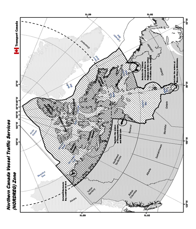
Mariners should be aware of the existence of the Northern Canada Vessel Traffic Services Zone established by the Northern Canada Vessel Traffic Services Zone Regulations. These regulations require certain vessels to report information to NORDREG before entering the NORDREG Zone and while navigating within it. In general, the NORDREG zone covers the waters of Ungava Bay, Hudson Bay and James Bay and Canada's coastal northern waters within the area enclosed by the 60th parallel of north latitude, the 141st meridian of west longitude and the outer limit of the exclusive economic zone; however, where the international boundary between Canada and Greenland is less than 200 nautical miles from the baselines of the territorial sea of Canada, the international boundary shall be substituted for that outer limit.
Ice operations support to NORDREG is provided by the Canadian Coast Guard. Icebreaker assistance as well as ice information and ice routing should be requested through NORDREG. For more detailed information on this VTS system, the definition of waters it covers and the requirements to make certain reports and obtain clearance, mariners should refer to Part 3 of the Radio Aids to Marine Navigation (Atlantic, St. Lawrence, Great Lakes, Lake Winnipeg and Eastern Arctic).
(a) For general information on ice conditions:
Address: NORDREG CANADA,
P.O. Box 189,
Iqaluit (NU)
X0A 0H0
Telephone: (867) 979-5724 or 979-5269
Facsimile: (867) 979-4264
Radiogram: NORDREG CANADA
*706 MARINE COMMUNICATIONS AND TRAFFIC SERVICES (MCTS) - ESTABLISHMENT OF ARCTIC MARITIME SAFETY INFORMATION SERVICES - 5 NEW ARCTIC NAVAREAS/METAREAS
The International Maritime Organization (IMO), the International Hydrographic Organization (IHO), and the World Meteorological Organization (WMO) announce the establishment of five (5) new Arctic NAVAREAs/METAREAs as part of the expansion of the IMO/IHO World-Wide Navigational Warning Service (WWNWS) into Arctic waters. The limits of the new Arctic NAVAREAs/METAREAs are identified in the attached graphic. Effective 01 July 2010, an International SafetyNET Service for broadcasting navigational warnings and meteorological warnings and forecasts in the English language will be declared to be in an "Initial Operational Capability" (IOC) for these waters with a transition to "Full Operational Capability" (FOC) on 01 June 2011.
During the IOC period, these Arctic NAVAREA/METAREAs will be providing navigational warnings and meteorological warnings and forecasts on an intermittent and test basis. The broadcasting of SafetyNET messages to the new Arctic NAVAREA/METAREAs will be addressed to rectangular area(s) until the SafetyNET receiver modifications with the inclusion of the NAVAREA/METAREAs boundary limits and its identification are in place. Reception of rectangular addressed messages should be automatic providing the ship's position is inside the addressed area. However, mariners are advised to check their manufacturer's operation manuals to obtain information on the setting of their EGC receivers to receive relevant SafetyNET messages.
Arctic NAVAREA Co-ordinators and METAREA Issuing Services are:
NAVAREA/METAREA XVII - CANADA
NAVAREA/METAREA XVIII - CANADA
NAVAREA/METAREA XIX - NORWAY
NAVAREA/METAREA XX- RUSSIAN FEDERATION
NAVAREA/METAREA XXI - RUSSIAN FEDERATION
Arctic NAVAREA/METAREA Boundary limits:
NAVAREA/METAREA XVII bound by:
67° 00'.00N 168° 58'.00W,
90° 00'.00N 168° 58'.00W,
90° 00'.00N 120° 00'.00W,
south to the Canadian coastline along the 120°00'.00W meridian;
NAVAREA/METAREA XVIII bound by:
A position on the Canadian coastline at the 120°00'.00W meridian to:
90° 00'.00N 120°00'.00W,
90° 00'.00N 035°00'.00W,
67° 00'.00N 035°00'.00W;
NAVAREA/METAREA XIX bound by:
From a position on the Norwegian coastline at 65°00'.00N to:
65° 00'.00N 005° 00'.00W,
75° 00'.00N 005° 00'.00W,
west to a position on the Greenland coastline;
From the border between Norway and Russia (Inland) to:
69° 47'.68N 030° 49'.16E,
69° 58'.48N 031° 06'.24E,
70° 22'.00N 031° 43'.00E,
71° 00'.00N 030° 00'.00E,
From this geographical position (71° 00'.00N . 030°00'.00E) further north
along the 030° 00'.00E meridian to:
90° 00'.00N 030° 00'.00E,
90° 00'.00N 035° 00'.00W,
south to the Greenland coastline along the 035° 00'.00W meridian;
NAVAREA/METAREA XX bound by:
From the border between Norway and Russia (Inland) to:
69° 47'.68N 030° 49'.16E,
69° 58'.48N 031° 06'.24E,
70° 22'.00N 031° 43'.00E,
71° 00'.00N 030° 00'.00E,
From this geographical position (71° 00'.00N . 030°00'.00E) further north along
the 030°00'.00E meridian to:
90° 00'.00N 030° 00'.00E,
90° 00'.00N 125° 00'.00E,
then south to the Russian Federation coastline along the 125° 00'.00E meridian;
NAVAREA/METAREA XXI bound by:
From a geographical position on the Russian Federation coastline at
the 125°00'. 00E meridian to:
90° 00'.00N 125° 00'.00E,
90° 00'.00N 168° 58'.00W,
67° 00'.00N 168° 58'.00W,
west to a geographical position on the Russian Federation coastline along
the 67° 00'.00N parallel
Arctic NAVAREA Broadcast Schedules:
NAVAREA XVII (POR) at 1130UTC and 2330UTC
NAVAREA XVIII (AOR-W) at 1100UTC and 2300UTC
NAVAREA XIX (AOR-E) at 0630UTC and 1830UTC
NAVAREA XX (IOR) at 0530UTC and1730UTC
NAVAREA XXI (POR) at 0630UTC and 1830UC
Arctic METAREA Broadcast Schedules:
METAREA XVII (POR) at 0300UTC and 1500UTC
METAREA XVIII (AOR-W) at 0300UTC and 1500UTC
METAREA XIX (AOR-E) at 1100UTC and 2300UTC
METAREA XX (IOR) at 0600UTC and 1800UTC
METAREA XXI (POR) at 0600UTC and 1800UTC
Feedback concerning the reception of NAVAREA broadcasts, especially above 76°N, is encouraged and may be sent to:
NAVAREA XVII and XVIII - CANADA
Prescott MCTS Centre
Telephone: +1-613-925-4471
Facsimile: +1-613-925-4519
Email: navarea17.18@innav.gc.ca
NAVAREA XIX - NORWAY
Vardoe VTS Centre
Telephone: +47 78 98 98 98
Facsimile: +47 78 98 98 99
Email: navarea19@kystverket.no
NAVAREA XX and XXI - RUSSIAN FEDERATION
Chief of MSI Division
Telephone: +7 812 570 34 66
Facsimile: +7 812 570 34 66
Email: ibm@hydrograph.spb.su
Feedback concerning the reception of METAREA broadcasts, especially above 76°N, is encouraged and may be sent to:
METAREA XVII and XVIII - CANADA
Contact: Mr. Tom King
Telephone: +1-709-256-6612
Facsimile: +1-709-256-6627
Email: Tom.King@ec.gc.ca
METAREA XIX - NORWAY
Contact: Mr. Helge Tangen
Telephone: +47 7762 1300
Facsimile: +47 7762-1301`
Email: helget@met.no
METAREA XX and XXI - RUSSIAN FEDERATION
Contact Name: Mr. Sergey Brestkin
Telephone: +7-812-352-1901
Facsimile: +7-812-352-2688
Email: gmdss@aari.ru
*707 CANADIAN HYDROGRAPHIC SERVICE - QUEEN CHARLOTTE ISLANDS, BC, NOW OFFICIALLY NAMED HAIDA GWAII
In December 2009, the Government of British Columbia agreed to rename the Queen Charlotte Islands, Haida Gwaii, as part of an historic reconciliation agreement between the province and the Haida Nation. The Geographical Names Board of Canada, the national body responsible for the naming of places and geographical features in Canada, confirmed that Haida Gwaii is now the official name of the Islands and will be reflected on all federal government maps.
The Canadian Hydrographic Service will be updating this name on an opportunity basis as New Products and New Editions are published.
CHART CORRECTIONS
3053 - Continuation A - Sheet 2 - New Chart - 11-APR-1986 - NAD 1927
02-JUL-2010 |
LNM/D. 05-FEB-2010 |
|
Affix |
patch |
50°42'42.0"N 119°17'54.0"W |
Download Patch - http://chartsvr.chs-shc.gc.ca/patches/3053_PA_291253.pdf |
||
DFO(6202271-01) |
||
3062 - Pitt Lake - Sheet 1 - New Chart - 24-MAY-1985 - NAD 1927
30-JUL-2010 |
LNM/D. 12-MAR-2010 |
|
Reposition |
red starboard hand lighted pillar buoy Fl R, marked L24 (See Chart No. 1, Qf) |
from 49°24'09.4"N 122°33'14.6"W |
to 49°24'11.4"N 122°33'13.9"W |
||
(P2010062) LL(373.3) DFO(6202280-01) |
||
Add |
red starboard hand conical buoy, marked L22 (See Chart No. 1, Qf) |
49°23'33.0"N 122°33'32.5"W |
(P2010068) DFO(6202286-01) |
||
3311 - Howe Sound Thornbrough Channel - Sheet 2 - New Edition - 31-DEC-1993 - NAD 1983
02-JUL-2010 |
LNM/D. 04-JUN-2010 |
|
Delete |
Fog Sig (Occas) (See Chart No. 1, R1) |
49°26'01.0"N 123°28'09.0"W |
DFO(6202270-01) |
||
3313 - Gulf Islands and Adjacent Waterways / et les Voies Navigables Adjacentes - New Edition - 02-JAN-2009 - NAD 1983
02-JUL-2010 |
LNM/D. 25-JUN-2010 |
|
Delete |
measured distance 1,845m-143°/323° on W side marked by two pairs of white triangular daymarks |
Page 6a under ANCHORAGES - BERTHS Sidney Spit: |
DFO(6202272-09) |
||
Delete |
distance mesurée 1 845 m-143°/323° du côté Ouest, marquée par deux paires de marques de jour triangulaires blanches |
Page 6a under MOUILLAGES - POSTES D'AMARRAGE Sidney Spit: |
DFO(6202272-10) |
||
3313 - Saanich Inlet - Sheet 13 - New Edition - 02-JAN-2009 - NAD 1983
02-JUL-2010 |
LNM/D. 25-JUN-2010 |
|
Delete |
Fog Sig (Ocass) (See Chart No. 1, R1) |
48°36'51.0"N 123°30'49.0"W |
(P2010037) LL(252.5) DFO(6202247-01) |
||
3313 - Brentwood Bay and / et Tod Inlet - Sheet 13 - New Edition - 02-JAN-2009 - NAD 1983
02-JUL-2010 |
LNM/D. 25-JUN-2010 |
|
Delete |
Fog Sig (Ocass) (See Chart No. 1, R1) |
48°34'39.3"N 123°28'08.5"W |
(P2010036) LL(252.3) DFO(6202246-01) |
||
3313 - Haro Strait North / Nord - Sheet 6 - New Edition - 02-JAN-2009 - NAD 1983
02-JUL-2010 |
LNM/D. 25-JUN-2010 |
||
Delete |
beacon marked (Priv) Bns (See Chart No. 1, Q80) |
48°38'14.7"N 123°20'27.3"W |
|
DFO(6202272-01) |
|||
Delete |
beacon (See Chart No. 1, Q80) |
48°38'15.3"N 123°20'26.2"W |
|
DFO(6202272-02) |
|||
Delete |
measured distance (See Chart No. 1, Q122) |
between 48°38'15.3"N 123°20'26.2"W |
|
and 48°37'48.2"N 123°21'19.9"W |
|||
DFO(6202272-03) |
|||
Delete |
measured distance (See Chart No. 1, Q122) |
between 48°37'49.9"N 123°21'16.6"W |
|
and 48°37'02.5"N 123°20'22.4"W |
|||
DFO(6202272-04) |
|||
Delete |
legend 143°-323° 1838m |
48°37'24.8"N 123°20'56.5"W |
|
DFO(6202272-05) |
|||
Delete |
measured distance (See Chart No. 1, Q122) |
between 48°37'01.5"N 123°20'23.9"W |
|
and 48°37'23.7"N 123°19'39.6"W |
|||
DFO(6202272-06) |
|||
Delete |
beacon (See Chart No. 1, Q80) |
48°37'23.2"N 123°19'40.7"W |
|
DFO(6202272-07) |
|||
Delete |
beacon marked Bns (Priv) (See Chart No. 1, Q80) |
48°37'23.7"N 123°19'39.6"W |
|
DFO(6202272-08) |
|||
3313 - Fulford Harbour - Sheet 8 - New Edition - 02-JAN-2009 - NAD 1983
02-JUL-2010 |
LNM/D. 25-JUN-2010 |
|
Delete |
Fog Sig (Occas) (See Chart No. 1, R1) |
48°46'12.0"N 123°26'51.0"W |
(P2010034) LL(244) DFO(6202245-01) |
||
3441 - Haro Strait, Boundary Pass and / et Satellite Channel - Sheet 1 - New Edition - 01-JUL-2005 - NAD 1983
02-JUL-2010 |
LNM/D. 11-DEC-2009 |
|
Delete |
Fog Sig (Occas) (See Chart No. 1, R1) |
48°46'14.0"N 123°26'43.0"W |
(P2010034) LL(244) DFO(6202245-01) |
||
Delete |
Fog Sig (Ocass) (See Chart No. 1, R1) |
48°34'42.0"N 123°27'38.0"W |
(P2010036) LL(252.3) DFO(6202246-01) |
||
Delete |
Fog Sig (Ocass) (See Chart No. 1, R1) |
48°36'51.0"N 123°30'49.0"W |
(P2010037) LL(252.5) DFO(6202247-01) |
||
Delete |
beacon marked (Priv) Bns (See Chart No. 1, Q80) |
48°38'14.7"N 123°20'27.1"W |
DFO(6202272-01) |
||
Delete |
measured distance (See Chart No. 1, Q122) |
between 48°38'14.7"N 123°20'27.1"W |
and 48°37'43.3"N 123°21'29.5"W |
||
DFO(6202272-03) |
||
Delete |
measured distance (See Chart No. 1, Q122) |
between 48°37'44.7"N 123°21'26.8"W |
and 48°36'57.1"N 123°20'32.0"W |
||
DFO(6202272-04) |
||
Delete |
legend 143°-323° 1838m |
48°37'21.0"N 123°20'59.6"W |
DFO(6202272-05) |
||
Delete |
measured distance (See Chart No. 1, Q122) |
between 48°36'56.0"N 123°20'34.2"W |
and 48°37'22.8"N 123°19'40.4"W |
||
DFO(6202272-06) |
||
Delete |
beacon marked (Bns) Priv (See Chart No. 1, Q80) |
48°37'22.8"N 123°19'40.4"W |
DFO(6202272-07) |
||
3447 - Nanaimo Harbour and / et Departure Bay - New Edition - 03-JUN-2005 - NAD 1983
02-JUL-2010 |
LNM/D. 21-AUG-2009 |
|
Delete |
Fog Sig (Occas) (See Chart No. 1, R1) |
49°11'40.0"N 123°57'25.5"W |
(P2010038) LL(445.1) DFO(6202248-01) |
||
3478 - Fulford Harbour - Sheet 1 - New Edition - 17-JUN-2005 - NAD 1983
02-JUL-2010 |
LNM/D. 29-JAN-2010 |
|
Delete |
Fog Sig (Occas) (See Chart No. 1, R1) |
48°46'11.0"N 123°26'53.0"W |
(P2010034) LL(244) DFO(6202245-01) |
||
Delete |
Fuel/Essence |
48°46'16.0"N 123°27'02.0"W |
DFO(6202245-02) |
||
3479 - Approaches to / Approches à Sidney - New Chart - 18-MAY-2007 - NAD 1983
02-JUL-2010 |
LNM/D. 02-APR-2010 |
|
Delete |
beacon marked (Priv) Bns (See Chart No. 1, Q80) |
48°38'14.7"N 123°20'27.3"W |
DFO(6202272-01) |
||
Delete |
beacon (See Chart No. 1, Q80) |
48°38'15.3"N 123°20'26.2"W |
DFO(6202272-02) |
||
Delete |
measured distance (See Chart No. 1, Q122) |
between 48°38'15.3"N 123°20'26.2"W |
and 48°37'48.2"N 123°21'19.9"W |
||
DFO(6202272-03) |
||
Delete |
measured distance (See Chart No. 1, Q122) |
between 48°37'50.0"N 123°21'16.8"W |
and 48°37'02.5"N 123°20'22.4"W |
||
DFO(6202272-04) |
||
Delete |
legend 143°-323° 1838m |
48°37'19.2"N 123°20'41.7"W |
DFO(6202272-05) |
||
Delete |
measured distance (See Chart No. 1, Q122) |
between 48°37'01.5"N 123°20'23.9"W |
and 48°37'23.7"N 123°19'39.6"W |
||
DFO(6202272-06) |
||
Delete |
beacon marked Priv (Bns) (See Chart No. 1, Q80) |
48°37'23.2"N 123°19'40.7"W |
DFO(6202272-07) |
||
Delete |
beacon (See Chart No. 1, Q80) |
48°37'23.7"N 123°19'39.6"W |
DFO(6202272-08) |
||
3495 - Vancouver Harbour Eastern Portion / Partie Est - Sheet 1 - New Edition - 12-NOV-2004 - NAD 1983
16-JUL-2010 |
LNM/D. 04-JUN-2010 |
|||
Delete |
light (Priv) F (See Chart No. 1, P1) |
49°17'34.4"N 122°52'53.2"W |
||
DFO(6202276-01) |
||||
This notice might affect Electronic Navigational Chart: CA570127 |
||||
Delete |
light F (Priv) (See Chart No. 1, P1) |
49°17'34.4"N 122°52'52.0"W |
||
DFO(6202276-02) |
||||
This notice might affect Electronic Navigational Chart: CA570127 |
||||
Add |
breakwater (See Chart No. 1, F4.1) |
between 49°17'34.4"N 122°52'53.2"W |
||
and 49°17'34.4"N 122°52'52.0"W |
||||
DFO(6202276-03) |
||||
This notice might affect Electronic Navigational Chart: CA570127 |
||||
Delete |
breakwater (See Chart No. 1, F4.1) |
between 49°17'34.3"N 122°52'47.1"W |
||
and 49°17'34.3"N 122°52'45.0"W |
||||
DFO(6202276-04) |
||||
This notice might affect Electronic Navigational Chart: CA570127 |
||||
Add |
light (Priv) F (See Chart No. 1, P1) |
49°17'34.3"N 122°52'47.1"W |
||
DFO(6202276-05) |
||||
This notice might affect Electronic Navigational Chart: CA570127 |
||||
Add |
light F (Priv) (See Chart No. 1, P1) |
49°17'34.3"N 122°52'45.0"W |
||
DFO(6202276-06) |
||||
This notice might affect Electronic Navigational Chart: CA570127 |
||||
Add |
light (Priv) F (See Chart No. 1, P1) |
49°17'33.6"N 122°53'18.9"W |
||
DFO(6202276-07) |
||||
This notice might affect Electronic Navigational Chart: CA570127 |
||||
Add |
light F (Priv) (See Chart No. 1, P1) |
49°17'33.8"N 122°53'17.8"W |
||
DFO(6202276-08) |
||||
This notice might affect Electronic Navigational Chart: CA570127 |
||||
3526 - Howe Sound - New Edition - 01-JUL-2005 - NAD 1983
02-JUL-2010 |
LNM/D. 04-JUN-2010 |
|
Delete |
Fog Sig (Occas) (See Chart No. 1, R1) |
49°26'00.0"N 123°28'00.0"W |
DFO(6202270-01) |
||
This notice might affect Electronic Navigational Chart: CA470004 |
||
3527 - Baynes Sound - New Edition - 06-APR-2001 - NAD 1983
02-JUL-2010 |
LNM/D. 20-APR-2007 |
|
Delete |
Fog Sig (Occas) (See Chart No. 1, R1) |
49°32'14.0"N 124°49'10.0"W |
(P2010039) LL(496.1) DFO(6202249-01) |
||
Delete |
Fog Sig (Occas) (See Chart No. 1, R1) |
49°31'43.0"N 124°50'34.0"W |
(P2010040) LL(496.2) DFO(6202250-01) |
||
Delete |
Fog Sig (Occas) (See Chart No. 1, R1) |
49°29'46.0"N 124°42'12.0"W |
(P2010041) LL(496.3) DFO(6202251-01) |
||
Delete |
Fog Sig (Occas) (See Chart No. 1, R1) |
49°30'39.0"N 124°42'39.0"W |
(P2010042) LL(496.4) DFO(6202252-01) |
||
3534 - Squamish Harbour - Sheet 1 - New Edition - 26-DEC-2003 - NAD 1983
16-JUL-2010 |
LNM/D. 04-JUN-2010 |
|
Add |
submarine cable (See Chart No. 1, L30.1) |
joining 49°39'58.5"N 123°12'00.0"W |
49°40'03.6"N 123°11'36.0"W |
||
49°40'06.0"N 123°11'04.2"W |
||
49°40'00.0"N 123°10'36.0"W |
||
49°40'03.3"N 123°10'16.2"W |
||
49°39'58.6"N 123°10'12.8"W |
||
49°39'59.0"N 123°10'11.5"W |
||
49°40'01.8"N 123°10'11.1"W |
||
49°40'03.3"N 123°10'09.9"W |
||
and 49°40'06.3"N 123°10'05.5"W |
||
DFO(6202279-01) |
||
3736 - Kitimat - Sheet 1 - New Edition - 31-AUG-1990 - NAD 1983
16-JUL-2010 |
LNM/D. 31-JUL-2009 |
|
Add |
breakwater (See Chart No. 1, F4.1) |
between 53°59'20.0"N 128°41'42.5"W |
and 53°59'20.2"N 128°41'39.1"W |
||
DFO(6202278-01) |
||
Add |
light Fl (Priv) (See Chart No. 1, P1) |
53°59'20.2"N 128°41'39.1"W |
DFO(6202278-02) |
||
L/C3854 - Tasu Sound to / à Port Louis - New Edition - 23-OCT-1987 - NAD 1927
16-JUL-2010 |
LNM/D. 23-OCT-2009 |
|
Delete |
depth of 27 fathoms (See Chart No. 1, I10) |
53°11'36.0"N 132°39'00.0"W |
DFO(6202277-01) |
||
Add |
depth of 8 fathoms (See Chart No. 1, I10) |
53°11'38.2"N 132°39'06.1"W |
DFO(6202277-02) |
||
3869 - Skidgate Channel to / à Tian Rock - Sheet 1 - New Edition - 28-NOV-1986 - Unknown
16-JUL-2010 |
LNM/D. 02-DEC-2005 |
|
Add |
depth of 8 fathoms (See Chart No. 1, I10) |
53°11'39.0"N 132°39'07.0"W |
DFO(6202277-02) |
||
3891 - Skidegate Channel - New Chart - 08-SEP-1989 - NAD 1983
16-JUL-2010 |
LNM/D. 28-MAY-2010 |
|
Add |
depth of 15.1 metres (See Chart No. 1, I10) |
53°11'37.2"N 132°39'11.9"W |
DFO(6202277-02) |
||
6453 - Mackenzie River / Fleuve Mackenzie (Kilometre Kilomètre 58-90) - New Edition - 25-JAN-2008 - NAD 1983
23-JUL-2010 |
||
Delete |
green port hand lighted pillar buoy Q G |
61°15'57.0"N 117°31'33.0"W |
(A2010005) LL(1722.8) DFO(6603602-01) |
||
Delete |
red starboard hand lighted pillar buoy Q R |
61°15'49.5"N 117°31'35.0"W |
(A2010004) LL(1722.7) DFO(6603602-02) |
||
7083 - Cambridge Bay to Shepherd Bay - New Edition - 15-JUN-1984 - Unknown
16-JUL-2010 |
LNM/D. 01-MAY-2009 |
|
Reposition |
red beacon, BnR and radar reflector |
from 69°00'36.0"N 100°39'54.0"W |
to 69°00'11.9"N 100°39'36.0"W |
||
DFO(6603587-01) |
||
Delete |
radar reflector against beacon, BnR |
69°18'50.0"N 099°53'00.0"W |
DFO(6603589-01) |
||
Add |
red beacon, BnR and radar reflector |
68°30'15.2"N 100°54'29.2"W |
DFO(6603591-02) |
||
Add |
red beacon, BnR and radar reflector |
69°25'55.0"N 093°54'55.0"W |
DFO(6603593-03) |
||
7573 - M'Clintock Channel, Larsen Sound and / et Franklin Strait - New Chart - 25-FEB-2000 - NAD 1983
23-JUL-2010 |
LNM/D. 01-MAY-2009 |
|
Add |
recommended main two way track |
joining 69°34'00.0"N 095°12'00.0"W |
69°35'00.0"N 095°14'48.0"W |
||
69°40'00.0"N 095°26'21.0"W |
||
69°41'00.0"N 095°35'33.0"W |
||
and 69°46'10.8"N 096°10'00.0"W |
||
DFO(6603604-01) |
||
This notice might affect Electronic Navigational Chart: CA273329 |
||
7725 - Requisite Channel and Approaches - New Edition - 22-JUN-1984 - Unknown
16-JUL-2010 |
LNM/D. 09-JUL-2010 |
|
Delete |
tower with elevation of 30ft. |
68°30'24.0"N 100°54'15.0"W |
DFO(6603591-01) |
||
Add |
red beacon, BnR and radar reflector. |
68°30'24.2"N 100°54'18.2"W |
DFO(6603591-02) |
||
09-JUL-2010 |
LNM/D. 14-MAR-2003 |
|
Amend |
legend 351° to read 351½° against leading beacons |
68°17'27.0"N 100°00'08.0"W |
DFO(6603601-01) |
||
7731 - Storis Passage and Approaches - New Edition - 25-MAY-1984 - Unknown
09-JUL-2010 |
LNM/D. 14-MAR-2003 |
|
Amend |
legend 351° to read 351½° against leading beacons |
68°17'40.0"N 100°00'08.0"W |
DFO(6603601-01) |
||
7760 - St. Roch and / et Rasmussen Basins - New Chart - 03-MAY-1968 - NAD 1927
16-JUL-2010 |
LNM/D. 01-MAY-2009 |
|
Reposition |
red beacon, BnR and radar reflector |
from 69°33'27.5"N 095°19'12.0"W |
to 69°33'17.3"N 095°19'12.4"W |
||
DFO(6603588-01) |
||
Reposition |
red beacon, BnR and radar reflector |
from 69°46'10.0"N 095°51'00.0"W |
to 69°46'01.3"N 095°50'41.0"W |
||
DFO(6603590-01) |
||
23-JUL-2010 |
LNM/D. 16-JUL-2010 |
|
Add |
recommended main two way track |
joining 69°32'01.0"N 095°04'59.0"W |
69°34'58.0"N 095°14'47.1"W |
||
69°39'58.0"N 095°26'20.1"W |
||
69°40'58.0"N 095°35'32.0"W |
||
and 69°46'08.8"N 096°09'59.1"W |
||
DFO(6603604-01) |
||
7760 - Goja Haven - New Chart - 03-MAY-1968 - NAD 1927
16-JUL-2010 |
LNM/D. 01-MAY-2009 |
|
Amend |
358½° to read 358° against leading beacons |
226½° 3000 ft from aeronautical radiobeacon (68°37'33"N 95°52'00"W). |
DFO(6603594-01) |
||
Amend |
BnR 55ft to read Bn against rear leading beacon. |
304½° 2760 ft from aeronautical radiobeacon (68°37'33"N 95°52'00"W). |
DFO(6603594-02) |
||
Amend |
BnR 25ft to read Bn against front leading beacon |
300¼° 2620 ft from aeronautical radiobeacon (68°37'33"N 95°52'00"W). |
DFO(6603594-03) |
||
7770 - Spence Bay and Approaches - New Edition - 27-AUG-1971 - NAD 1927
16-JUL-2010 |
LNM/D. 31-MAY-2002 |
|
Amend |
BnR 20ft to read BnR against beacon |
69°25'33.5"N 093°53'28.0"W |
DFO(6603593-01) |
||
Reposition |
red beacon, BnR and radar reflector |
from 69°25'33.5"N 093°53'28.0"W |
to 69°25'32.9"N 093°53'32.6"W |
||
DFO(6603593-02) |
||
Amend |
BnR 15ft to read BnR against beacon |
69°31'23.0"N 093°34'52.0"W |
DFO(6603595-01) |
||
Reposition |
Red beacon BnR |
from 69°31'23.0"N 093°34'52.0"W |
to 69°31'27.9"N 093°34'49.4"W |
||
DFO(6603595-02) |
||
7770 - Spence Bay - New Edition - 27-AUG-1971 - NAD 1927
16-JUL-2010 |
LNM/D. 31-MAY-2002 |
|
Amend |
BnR 15ft to read BnR against beacon |
253° 9625 ft from beacon (69°31'50"N 93°30'08"W) |
DFO(6603595-01) |
||
Reposition |
Red beacon BnR |
from 253° 9625 ft from beacon (69°31'50"N 93°30'08"W) to 255½° 9380 ft from beacon. |
DFO(6603595-02) |
||
7783 - Queen Maud Gulf Eastern Portion / Partie est - New Edition - 13-JUN-1997 - NAD 1983
16-JUL-2010 |
LNM/D. 23-AUG-2002 |
|
Delete |
red beacon, BnR and radar reflector |
69°00'12.0"N 100°39'09.4"W |
DFO(6603587-02) |
||
7784 - Victoria Strait - New Chart - 03-JUL-1998 - NAD 1983
16-JUL-2010 |
LNM/D. 12-JUL-2002 |
|
Reposition |
red beacon BnR and radar reflector |
from 69°00'12.0"N 100°39'09.4"W |
to 69°00'11.9"N 100°38'09.5"W |
||
DFO(6603587-01) |
||
This notice might affect Electronic Navigational Chart: CA373262 |
||
Delete |
radar reflector against beacon, BnR |
69°18'34.2"N 099°53'48.9"W |
DFO(6603589-01) |
||
This notice might affect Electronic Navigational Chart: CA373262 |
||
CORRECTIONS TO RADIO AIDS TO MARINE NAVIGATION
*710 CANADIAN COAST GUARD PUBLICATION – AMENDMENT TO THE RADIO AIDS TO MARINE NAVIGATION (PACIFIC AND WESTERN ARCTIC) PUBLICATION - 2010
Page v, TABLE OF CONTENTS
REPLACE PART 3 – VESSEL TRAFFIC SERVICES (VTS), Arctic Canada VTS NORDREG (chart) page 3-16 WITH:
Northern Canada Vessel Traffic Services (NORDREG) Zone (chart) 3-16
Page 3-3
REPLACE ZONE DESCRIPTIONS, ARCTIC CANADA WITH:
Northern Canada
The Northern Canada Vessel Traffic Services (NORDREG) Zone consists of:
(a) the shipping safety control zones prescribed by the Shipping Safety Control Zones Order;1
(b) the waters of Ungava Bay, Hudson Bay and Kugmallit Bay that are not in a shipping safety control zone;
(c) the waters of James Bay;
(d) the waters of Koksoak River from Ungava Bay to Kuujjuaq;
(e) the waters of Feuilles Bay from Ungava Bay to Tasiujaq;
(f) the waters of Chesterfield Inlet that are not within a shipping safety control zone and the waters of Baker Lake; and
(g) the waters of Moose River from James Bay to Moosonee.
1 The Shipping Safety Control Zones cover Canada’s coastal northern waters within the area enclosed by the 60th parallel of north latitude, the 141st meridian of west longitude and the outer limit of the exclusive economic zone; however, where the international boundary between Canada and Greenland is less than 200 nautical miles from the baselines of the territorial sea of Canada, the international boundary shall be substituted for that outer limit.
Page 3-3
REPLACE ZONE APPLICATION, ARCTIC CANADA LOCAL VTS ZONE (NORDREG) WITH:
Northern Canada VTS (NORDREG) Zone
With respect to the Northern Canada VTS (NORDREG) Zone the Northern Canada Vessel Traffic Services Zone Regulations apply to the following classes of vessels:
(a) vessels of 300 gross tonnage or more;
(b) vessels that are engaged in towing or pushing another vessel, if the combined gross tonnage of the vessel and the vessel being towed or pushed is 500 gross tonnage or more; and
(c) vessels that are carrying as cargo, a pollutant or dangerous goods, or that are engaged in towing or pushing a vessel that is carrying as cargo a pollutant or dangerous goods.
Participation is mandatory.
Page 3-7 to Page 3-8 ending with: "A report containing the required information listed in (a), (b), (d) and (h), shall be made immediately before the ship crosses the seaward boundary."
REPLACE NORDREG Zone Report WITH:
NORDREG Zone Reports
Format
NORDREG reports shall be addressed to NORDREG CANADA and communicated either directly to NORDREG CANADA or to the nearest Canadian Coast Guard MCTS Centre. The master of a ship shall ensure that these reports are made in accordance with the stated requirements.
The information requested from the ships is derived from the standard reporting format shown in International Maritime Organization resolution A.851(20) – General Principles for Ship Reporting Systems and Ship Reporting Requirements, Including Guidelines for Reporting Incidents Involving Dangerous Goods, Harmful Substances and/or Pollutants.
Every report shall begin with the term "NORDREG" (system identifier) and be followed by whichever of the following two letters corresponds to the report:
(a) "SP", in the case of a sailing plan report;
(b) "PR", in the case of a position report;
(c) "FR", in the case of a final report;
(d) "DR", in the case of a deviation report.
The report must include the applicable designators followed by the information required in accordance with the table on page 3-8.
Content and time and geographical position for submitting reports
Vessels shall send a report as follows, and provide the information required in accordance with the table on page 3-8 that corresponds to the designators specified:
When the vessel is about to enter the NORDREG Zone
A sailing plan report (SP) shall be provided when the vessel is about to enter the NORDREG zone and must include the following designators: A, B, either C or D, E, F, G, H, I, L, O, P, Q, S, T, W, and X.
Note: Designators O, Q, T are not required when entering directly from the ECAREG Zone.
Vessels about to enter the NORDREG zone should provide the sailing plan report 24 hours in advance of entering the zone, or as soon as possible after leaving a port that is less than 24 hours from the NORDREG Zone. This ensures vessels are not delayed in obtaining a clearance from MCTS and enables MCTS to assess current conditions and prepare relevant safety information for the vessel.1
1Vessels must obtain a clearance from MCTS before entering the NORDREG zone.
Departing a berth/anchorage
A sailing plan report (SP) shall be provided more than one hour but not more than two hours before a vessel departs from a berth within the NORDREG Zone, unless the vessel is moving to another berth in the same port. The sailing plan report must include the following designators: A, B, either C or D, H, I, L, O, P, Q, S, T, W, and X.
Note: Designators O, P, Q, S, T, W, X are not required if the corresponding information has not changed since the previous sailing plan report.
Getting Underway After an Incident
A sailing plan report (SP) shall be provided immediately before a vessels gets underway within the NORDREG Zone if the vessel; has been stranded, has stopped as a result of a breakdown in the main propulsion systems or steering systems, has been involved in a collision. The sailing plan report must include the following designators: A, B, either C or D, I, L, O, P, Q, S, T, W and X.
Note: Designators O, P, Q, S, T, W, X are not required if the corresponding information has not changed since the previous sailing plan report.
Entering at Zone Boundary
A position report (PR) shall be provided immediately after a vessel enters the NORDREG Zone and must include the following designators: A, B, either C or D, E, F, and S.
Daily
A position report (PR) shall be provided daily at 1600 UTC, unless the vessel is transmitting LRIT information. The position report shall include the following designators: A, B, either C or D, E, F, and S.
Other Situations
A position report (PR) shall be provided with designators A, B, either C or D, E, F, S and X as soon as feasible after a vessel’s master becomes aware of any of the following:
- another vessel in apparent difficulty,
- any obstruction to navigation,
- any aid to navigation that is not functioning properly or is damaged, out of position or missing.
- any ice or weather conditions that are hazardous to safe navigation
- a pollutant in the water.
Arrival at berth/anchorage
A final report (FR) shall be provided on the arrival of a vessel at a berth within the NORDREG Zone and include the following designators: A and K.
Exiting the Zone
A final report (FR) shall be provided immediately before a vessel exits the NORDREG Zone and include the following designators: A and K
Deviation Report
A deviation report (DR) shall be provided when a vessel’s position varies significantly from the position that was expected based on the sailing plan report, or when a vessel’s intended voyage changes from the sailing plan report. The deviation report must include the following designators: A, B, either C or D and the other designators included in the sailing plan report if the corresponding information has changed since that report.
Designator |
Subject and Information Required |
|
A |
Vessel |
The vessel’s name, the name of the state whose flag the vessel in entitled to fly and, if applicable, the vessel’s call sign, International Maritime Organization ship identification number and Maritime Mobile Service Identity (MMSI) number. |
B |
Date and time |
Date and time corresponding to the vessel’s position under designator C or D given in Coordinated Universal Time (UTC). A 6-digit group followed by a Z, the first 2 digits giving the day of the month, the next two digits giving the hour and the last two digits giving the minutes. |
C |
Vessel’s position |
A 4-digit group giving latitude in degrees and minutes suffixed with N and a 5-digit group giving longitude in degrees and minutes suffixed with W. |
| Vessel’s position by geographical name of place. | If the vessel is at a known place, the name of the place. If the vessel is not at a known place, the name of a known place followed by the vessel’s true bearing (3-digits) and distance in nautical miles from the place. | |
E |
Vessel’s course. |
True course. A 3-digit group. |
F |
Vessel’s speed. |
Speed in knots. A 2-digit group. |
G |
The vessel’s last port of call. |
The name of the port of call. |
H |
Vessel’s entry into the NORDREG Zone or departure from a berth within the NORDREG Zone. |
Estimated date and time the vessel will enter the NORDREG Zone or depart the berth within the NORDREG Zone, as appropriate. Date and time expressed as under designator B and entry or departure position expressed as under designator C or D. |
I |
Vessel’s destination and expected time of arrival. |
The name of the destination followed by expected time of arrival, expressed as under designator B. |
K |
Vessel’s exit from the NORDREG Zone or arrival at the vessel’s destination. |
Date and time vessel exits the NORDREG Zone or arrives at its berth within the NORDREG Zone. Exit date and time expressed as under designator B and exit or arrival position expressed as under designator C or D. |
L |
Vessel’s intended route. |
A brief description of the intended route through the NORDREG Zone. |
O |
Vessel’s maximum present static draught. |
A 4-digit group giving metres and centimetres. |
P |
Cargo. |
A brief description of the vessel’s cargo and the cargo of any vessel being towed or pushed. The description must include: (a) in the case of a dangerous good, the class and quantity; and (b) in the case of a pollutant, the technical name and quantity. |
Q |
Defects, damage and deficiencies, as well as circumstances adversely affecting the vessel’s normal navigation. |
Brief details of any defects, damage or deficiencies of the vessel or its machinery, equipment or charts and nautical publications, or circumstances that adversely affect normal navigation. |
S |
Weather and Ice. |
A brief description of the prevailing weather and ice conditions. |
T |
Vessel’s authorized representative, agent or owner. |
The name and contact information of; |
W |
Persons on board the vessel. |
The number of persons. |
X |
Additional information for sailing plan report. |
(a) In the case of a sailing plan report the following information:
(b) In the case of a position report required after becoming aware of: another vessel in difficulty; any obstruction to navigation; an aid to navigation that is not functioning properly or is damaged, out of position or missing; any ice or weather conditions that are hazardous to safe navigation and a pollutant in the water - then a brief description of the applicable matter. |
Page 3-16
ARCTIC CANADA VESSEL TRAFFIC SERVICES (NORDREG) ZONE
DELETE CHART AND REPLACE WITH:
SAILING DIRECTIONS AND SMALL CRAFT GUIDE CORRECTIONS
British Columbia, Volume 1, Seventeenth Edition, 2004 -
Chapter 2 - Delete paragraph 144.
(P2010-22.01)
PACIFIC |
||||||||||
244 G5352 |
Fulford Harbour |
On ferry landing slip. 48 46 10.8 123 27 06.7 |
Fl |
W |
4s |
..... |
..... |
............................. |
Privately maintained. Year round. Chart:3478 Edn 07/10(P10-034) |
|
252.3 G5350.4 |
Brentwood Bay Ferry Fog Signal |
Delete from list. Chart:3441 Edn 07/10(P10-036) |
||||||||
252.5 G5350.6 |
Mill Bay Ferry Fog Signal |
Delete from list. Chart:3441 Edn 07/10(P10-037) |
||||||||
372.5 |
Pitt Lake light buoy L11 |
49 21 17.4 122 34 50.5 |
Fl |
G |
4s |
..... |
..... |
Green, marked "L11". |
Year round. Chart:3062 Edn 07/10(P10-064) |
|
373.3 |
Pitt Lake North light buoy L24 |
49 24 11.4 122 33 13.9 |
Fl |
R |
4s |
..... |
..... |
Red, marked "L24". |
Year round. Chart:3062 Edn 07/10(P10-062) |
|
373.4 |
Pitt Lake light buoy L23 |
49 23 58.8 122 33 28.9 |
Fl |
G |
4s |
..... |
..... |
Green, marked "L23". |
Year round. Chart:3062 Edn 07/10(P10-063) |
|
445.1 G5497 |
Departure Bay Ferry Landing Fog Signal |
Delete from list. Chart:3447 Edn 07/10(P10-038) |
||||||||
479.8 G5573 |
Refuge Cove |
SW. tip of West Redonda Island. 50 06 56.9 124 50 58.8 |
Fl |
R |
4s |
6.4 |
4 |
White cylindrical tower, red band at top. |
Year round. Chart:3538 Edn 07/10(P10-057) |
|
496.1 G5537 |
Denman Island Ferry Landing |
W. side of island. 49 32 05.9 124 49 26.7 |
F |
Y |
..... |
7.6 |
..... |
On dolphin. |
Privately maintained. Year round. Chart:3527 Edn 07/10(P10-039) |
|
496.2 G5535 |
Buckley Bay Ferry Landing |
S. side of landing. 49 31 35.4 124 50 50.9 |
F |
Y |
..... |
7.6 |
..... |
On dolphin. |
Privately maintained. Year round. Chart:3527 Edn 07/10(P10-040) |
|
496.3 G5540 |
Denman Island East Ferry Landing |
Gravelly Bay. 49 29 40.3 124 42 30.1 |
F |
Y |
..... |
7.6 |
..... |
On dolphin. |
Privately maintained. Year round. Chart:3527 Edn 07/10(P10-041) |
|
496.4 G5531 |
Hornby Island Ferry Landing |
SE. of Shingle Spit. 49 30 40 124 42 17.9 |
F |
Y |
..... |
7.6 |
..... |
On dolphin. |
Privately maintained. Year round. Chart:3527 Edn 07/10(P10-042) |
|
651.2 G5739.5 |
Hartley Bay Breakwater |
End of boulder breakwater. Entrance to Hartley Bay. 53 25 25.4 129 15 03.4 |
Q |
R |
1s |
7.2 |
3 |
White square skeleton tower, red and white triangular daymark. |
Year round. Chart:3945 Edn 07/10(P10-069) |
|
761 G5972 |
Lord Rock (U.S.) |
On highest point of rock. 54 43 32.8 130 49 13.2 |
Fl |
W |
4s |
11.6 |
7 |
Skeleton tower, red and white diamond daymark. |
Year round. Chart:3960 Edn 07/10(P10-059) |
|

