
Archived information
The Standard on Web Usability replaces this content. This content is archived because Common Look and Feel 2.0 Standards have been rescinded.
Archived information is provided for reference, research or recordkeeping purposes. It is not subject to the Government of Canada Web Standards and has not been altered or updated since it was archived.
|
|
Fisheries and Oceans Canada |
Pêches et Océans Canada |
VOL. 36, MONTHLY EDITION NO 04 April 29, 2011 Publication Number 40063779 |
NOTICES TO MARINERS
PUBLICATION EASTERN EDITION |
|||
Published monthly by the
CANADIAN COAST GUARD |
|||
|
|
|||
Page |
|||
| Section 1 |
Safety and General Information | 1 - 9 |
|
| Section 2 |
Chart Corrections | 10 - 26 |
|
| Section 3 |
Corrections to Radio Aids to Marine Navigation | NIL |
|
| Section 4 |
Sailing Directions and Small Craft Guide Corrections | 27 - 32 |
|
| Section 5 |
List of Lights, Buoys and Fog signals Corrections | 33 - 37 |
|
Maritime Services Directorate Aids to Navigation |
|||
EXPLANATORY NOTES |
Geographical positions refer directly to the graduations of the largest scale Canadian Hydrographic chart unless otherwise indicated. |
Bearings refer to the true compass and are measured clockwise from 000° (North) clockwise to 359°; those relating to lights are from seaward. |
Visibility of lights is that in clear weather. |
Depths - The units used for soundings (metres, fathoms or feet) are stated in the title of each chart. |
Elevations are normally given above Higher High Water, Large Tides unless otherwise indicated. |
Distances may be calculated as follows: |
1 nautical mile = 1 852 metres (6,076.1 feet) 1 statute mile = 1 609.3 metres (5,280 feet) 1 metre = 3.28 feet |
Temporary & Preliminary Notices are indicated by a (T) or a (P) before the chart action and in the section 1. Please note that Nautical charts are not amended by the Canadian Hydrographic Service for Temporary (T) and Preliminary (P) Notices. It is recommended that mariners chart these corrections in pencil. Listing of charts affected by Temporary and Preliminary Notices are revised and promulgated quarterly in Section 1 of the Monthly Edition . |
Please note that, in addition to the temporary and preliminary changes normally advertised as (T) and (P) Notices, there are a few permanent changes to navigational aids that have been advertised as Preliminary Notices to Mariners while charts are being updated for new editions. |
Marine Information Report & Suggestion Sheet - Mariners are requested to notify the responsible authorities when new or suspected dangers to navigation are discovered, changes observed in aids to navigation or corrections to publications are seen to be necessary. Such communications can be made using the Marine Information Report & Suggestion Sheet inserted on the last page of each monthly edition of Notices to Mariners. |
Monthly Notices to Mariners - WEB ACCESS -We are offering a feature where subscribers to our on-line service are able to receive the complete electronic monthly edition of our Notices to Mariners. We are encouraging our clients to visit the http://www.notmar.gc.ca/subscribe/ user-friendly web site to subscribe for this service. Users wishing to receive information updates for their charts can do so by setting up a "User Profile" on the following web page – http://www.notmar.gc.ca/search/mycharts-eng.php?czoxOToibnRtPXN0ZXBfb25lJmxhbmc9ZSI7. This feature permits users to register the nautical charts they currently have in their possession. Registrants are then automatically notified by e-mail when a Notices to Mariners is published concerning these charts. |
Canadian Nautical Charts & Publications - A source list of Canadian Nautical Charts & publications is published in Notice No. 14 of the Notices to Mariners Annual Edition April 2010. The source supply and the prices effective at the time of printing are listed. For current chart edition dates refer to the following web site: http://www.chs-shc.gc.ca/charts-cartes/paper-papier/index-eng.asp |
NOTE: Cette publication est aussi disponible en français. |
CHART CORRECTIONS - SECTION 2 |
|
Corrections to nautical charts will be listed in numeric order by chart number. Each chart correction listed applies only to that particular chart. Related charts, if any, will have their own specific correction listed separately. Users should also refer to CHS Chart 1 Symbols, Abbreviations Terms for additional information pertaining to the correction of charts. The illustration below describes the elements that will comprise a typical Section 2 chart correction. |

ADVISORY |
|
NOTICES TO SHIPPING (WRITTEN AND BROADCAST) |
|
The Canadian Coast Guard is implementing a number of changes to the aids to navigation system in Canada . |
|
These changes are advertised as Notices to Shipping (Broadcast and Written) by the Canadian Coast Guard and are followed up with Notices to Mariners, then charts are updated by hand correction, reprints or new editions. |
|
Mariners are advised that all relevant Written Notices to Shipping should be kept until superseded by Notices to Mariners or through revised charts issued by the Canadian Hydrographic Service. |
|
Written Notices to Shipping are published weekly and are available from local Canadian Coast Guard Offices. |
|
The Canadian Hydrographic Service is reviewing the impact of these changes with the Canadian Coast Guard and together we are preparing an action plan on the issuing of chart revisions. |
|
For further information contact your local Regional Notices to Shipping (Notships) issuing authorities. |
|
|

|
MONTHLY EDITION OF NOTICES TO MARINERS |
WEB ACCESS |
We are offering a feature where subscribers to our on-line service are able to receive the complete electronic monthly edition of our Notices to Mariners. We are encouraging our clients to visit the http://www.notmar.gc.ca /subscribe / web site to subscribe for this service. Users wishing to receive information updates for their charts can do so by setting up a "User Profile" on the following web page http://www.notmar.gc.ca/search/mycharts-eng.php?czoxOToibnRtPXN0ZXBfb25lJmxhbmc9ZSI7 This feature permits users to register the nautical charts they currently have in their possession. Registrants are then automatically notified by e-mail when a Notice to Mariners is published concerning these charts. |
INDEX |
|
CANADIAN HYDROGRAPHIC SERVICE - ANNOUNCEMENT REGARDING CANADIAN HYDROGRAPHIC SERVICE CHART PATCHES |
1 |
CANADIAN HYDROGRAPHIC SERVICE - CUMULATIVE CHART CORRECTIONS |
1 |
CANADIAN HYDROGRAPHIC SERVICE - CURRENT CHART EDITION DATES |
1 |
CANADIAN HYDROGRAPHIC SERVICE - PRINT ON DEMAND CHARTS - CARE AND USE |
1 |
CANADIAN HYDROGRAPHIC SERVICE - TRANSPORT CANADA NAVIGATION SAFETY - ECDIS |
1 |
*418(P) BAIE DES CHALEURS/CHALEUR BAY - BUOYS TO BE DISCONTINUED |
8 |
*410(P) BLANC SABLON - BUOY TO BE DISCONTINUED |
5 |
*407 CANADIAN COAST GUARD - LIST OF CHARTS AND REFERENCE CHARTS (SECTION I) AFFECTED BY TEMPORARY AND PRELIMINARY NOTICES |
4 |
*409 CANADIAN COAST GUARD PUBLICATION - INLAND WATERS LIST OF LIGHTS, BUOYS AND FOG SIGNALS - 2009 |
5 |
*406 CANADIAN COAST GUARD PUBLICATIONS - NEW EDITION OF THE ANNUAL EDITION OF NOTICES TO MARINERS - 2011 |
4 |
*404 CANADIAN COAST GUARD PUBLICATIONS - NEW EDITION OF RADIO AIDS TO MARINE NAVIGATION (ATLANTIC, ST. LAWRENCE, GREAT LAKES, LAKE WINNIPEG AND EASTERN ARCTIC) - 2011 |
3 |
*405 CANADIAN COAST GUARD PUBLICATIONS - NEW EDITION OF RADIO AIDS TO MARINE NAVIGATION (PACIFIC AND WESTERN ARCTIC) - 2011 |
4 |
*402 CANADIAN HYDROGRAPHIC SERVICE - ELECTRONIC NAVIGATIONAL CHARTS |
2 |
*401 CANADIAN HYDROGRAPHIC SERVICE - NAUTICAL CHARTS |
2 |
*403 CANADIAN HYDROGRAPHIC SERVICE - RASTER DIGITAL CHART (BSB V4) |
3 |
*412(P) CANSO HARBOUR TO/AU STRAIT OF CANSO - LIGHT BUOY TO BE DISCONTINUED |
6 |
*413(P) CAPE GEORGE TO/À PICTOU - RANGE LIGHTS TO BE DISCONTINUED |
6 |
*422(P) CAPE TORMENTINE À/TO WEST POINT - BUOYS TO BE DISCONTINUED |
8 |
*421(T) HARBOURS IN THE BAY OF FUNDY/PORTS DANS LA BAIE DE FUNDY SOUTHWEST COAST/CÔTÉ SUD- OUEST - LIGHT BUOY TEMPORARY ESTABLISHED |
8 |
*420 LAC SAINT-PIERRE - DAYBEACON DISCONTINUED |
8 |
*415(P) MALPEQUE BAY - LIGHTS TO BE DISCONTINUED |
7 |
*417 PLANS - ÎLE D'ANTICOSTI - DAYBEACON DISCONTINUED |
7 |
*414(P) PICTOU ISLAND TO/AUX TRYON SHOALS - RANGE LIGHTS TO BE DISCONTINUED |
6 |
*419 POINTE DES MONTS AUX/TO ESCOUMINS - DAYBEACONS DISCONTINUED |
8 |
*411(P) ST. PETERS BAY TO/À STRAIT OF CANSO - BUOYS TO BE DISCONTINUED |
5 |
*416(P) TRYON SHOALS TO/À CAPE EGMONT - BUOY TO BE DISCONTINUED |
7 |
NUMERICAL INDEX OF CANADIAN CHARTS AFFECTED |
|||||
Chart No. |
Page |
Chart No. |
Page |
Chart No. |
Page |
1234 |
10 |
4328 |
20 |
||
1236 |
8,10,11 |
4404 |
6 |
||
1310 |
11 |
4405 |
6,7 |
||
1312 |
8,11 |
4406 |
7 |
||
1314 |
11-13 |
4422 |
20,21 |
||
1315 |
13 |
4430 |
7,21 |
||
1317 |
13-15 |
4452 |
21 |
||
1351 |
15 |
4459 |
21,22 |
||
1430 |
15 |
4468 |
22,23 |
||
1510 |
15 |
4469 |
23 |
||
2042 |
15 |
4486 |
8,23,24 |
||
2085 |
2 |
4491 |
7 |
||
3860 |
2 |
4492 |
24,25 |
||
4021 |
15,16 |
4905 |
8,9 |
||
4024 |
16 |
4980 |
5 |
||
4026 |
16 |
6422 |
2 |
||
4099 |
16 |
6423 |
2 |
||
4114 |
16 |
7662 |
25,26 |
||
4115 |
17 |
7777 |
26 |
||
4124 |
8,17 |
8007 |
26 |
||
4140 |
17-19 |
||||
4145 |
19 |
||||
L/C 4227 |
19 |
||||
4236 |
19 |
||||
4243 |
20 |
||||
4307 |
6 |
||||
4308 |
5,6 |
||||
CANADIAN HYDROGRAPHIC SERVICE - ANNOUNCEMENT REGARDING CANADIAN HYDROGRAPHIC SERVICE CHART PATCHES
Colour Web Patches are free to the mariner, and given the quality of many printers, should reproduce well. They will be available in real time all around the world.
CHS welcomes your feedback on this service at chsinfo@dfo-mpo.gc.ca
CANADIAN HYDROGRAPHIC SERVICE - CUMULATIVE CHART CORRECTIONS
The cumulative Notices to Mariners corrections for charts can now be accessed at
http://www.notmar.gc.ca/search/notmar-eng.php
CANADIAN HYDROGRAPHIC SERVICE - CURRENT CHART EDITION DATES
CHART EDITIONS |
The three terms described below are used to indicate the publication status of Canadian charts. |
NEW CHART - "NEWCHT" |
The first publication of a Canadian chart embracing an area not previously charted to the scale shown, or embracing an area different from any existing Canadian chart. |
NEW EDITION - "NEWEDT" |
A new issue of an existing chart containing amendments essential to navigation in addition to those issued in Notices to Mariners and making existing editions obsolete. |
REPRINTS |
A new issue of the current edition of a chart incorporating no amendments of navigational significance other than those previously promulgated in Notices to Mariners. It may also contain amendments from other sources provided they are not essential to navigation. Previous printings of the current edition remain in force. |
The current chart edition dates can be accessed at http://www.chs-shc.gc.ca/charts-cartes/paper-papier/index-eng.asp
CANADIAN HYDROGRAPHIC SERVICE - PRINT ON DEMAND CHARTS - CARE AND USE
Background By providing nautical charts to the public, the goal of the Canadian Hydrographic Service (CHS) is to provide services for safe navigation in a fiscally responsible manner. As a result, CHS continues to expand its portfolio of nautical paper charts that are printed using Print On Demand (POD) technology. These charts are easily recognized by their whiter paper and the coloured logo of the Canadian Hydrographic Service. This new technology enables CHS to print charts in a more efficient manner while enhancing chart content through being able to quickly add new and important information. POD technology provides customers with up-to-date charts without the historical hand-drawn corrections or glued-on patches. Additionally, this technology eliminates out-of-stock situations which arise with the traditional printing and warehousing methods. In the event of a national emergency, CHS can respond to the appropriate authorities with best available information very quickly. Care of Your POD Chart CHS encourages its customers to handle the POD charts more carefully than the traditional lithographic charts. When plotting information on POD charts, use HB pencils and apply limited pressure. Testing has suggested that an Indian gum eraser is more effective than alternatives when used on the product. This eraser is also suitable for charts printed using lithographic processes. |
CANADIAN HYDROGRAPHIC SERVICE - TRANSPORT CANADA NAVIGATION SAFETY - ECDIS
Mariners are advised that ECDIS may not display some isolated shoal depths when operating in "base or standard display" mode. Route planning and monitoring alarms for these shoal depths may not always be activated. To ensure safe navigation and to confirm that a planned route is clear of such dangers, mariners should visually inspect the planned route and any deviations from it using ECDIS configured to display "all data". The automated voyage planning check function should not be solely relied upon. |
*401 CANADIAN HYDROGRAPHIC SERVICE - NAUTICAL CHARTS
CHARTS |
MAIN TITLE |
SCALE |
PUBLISHED |
CAT# |
PRICE |
New Editions |
All temporary and preliminary notices affecting the previous versions of the following chart(s) (is / are) now cancelled. For any outstanding notices please consult section 2 of this edition. |
||||
2085 |
Toronto Harbour |
1:15000 |
04-MAR-2011 |
3 |
$20.00 |
3860 |
Harbours on the West Coast of / Havres sur la côte ouest de Graham Island |
---- |
06-AUG-2010 |
2 |
$20.00 |
6422 |
Fort Good Hope to/à Askew Islands Kilometre 1100 / Kilometre 1180 |
1:50000 |
11-FEB-2011 |
4 |
$12.00 |
6423 |
Askew Islands to/à Bryan Island Kilometre 1180 / Kilometre 1240 |
1:50000 |
11-FEB-2011 |
4 |
$12.00 |
*402 CANADIAN HYDROGRAPHIC SERVICE - ELECTRONIC NAVIGATIONAL CHARTS
RELEASED PRODUCTS |
|
S-57 ENC NUMBER |
CHART TITLE |
CA573406 |
Grise Fiord |
CA370381 |
Strait of Georgia, Central Portion / Partie Centrale (Part 1 of 2) |
CA576005 |
Saint John Harbour and Approaches / et les approches |
CA476006 |
Annapolis Basin |
CA376014 |
Cape Sable Island to / aux Tusket Islands |
CA376015 |
Motion Bay to / à Cape St Francis |
CA376018 |
Tusket Islands to / au Cape St. Marys |
CA576020 |
Yarmouth Harbour and Approaches / et les approches |
CA576033 |
Campobello Island |
CA476043 |
Cape Sable to / à Pubnico Harbour |
CA376049 |
Nunasuk Island to Calf, Cow and Bull Islands |
CA376050 |
Seniartlit Islands to Nain |
CA376062 |
West Point à / to Baie de Tracadie |
CA476063 |
Great Bras D'Or, St. Andrews Channel and / et St. Anns Bay |
CA376070 |
Renews Harbour to / à Motion Bay |
CA576082 |
Come by Chance and / et Arnold's Cove |
CA576088 |
Port Harmon |
CA276092 |
Cape Race to Cape Freels |
CA376093 |
Flint Island to Cape Smoky |
CA576095 |
Sydney Harbour |
CA276101 |
Grand Bank, Northern Portion / Grand Banc, Partie Nord to / à la Flemish Pass |
CA376106 |
Cape Pine to / à Renews Harbour |
CA576110 |
Port Bickerton |
CA276113 |
Cape Harrison to / à St. Michael Bay |
CA376120 |
Conception Bay |
CA176140 |
Cape Breton to / à Cape Cod |
CA476141 |
Great Bras D'Or and / et St. Patricks Channel |
CA376164 |
Burin Peninsula to Saint-Pierre |
CA376173 |
Cape St. Mary's to Argentia Harbour and Jude Island |
CA576177 |
Charlottetown Harbour |
CA476179 |
Hillsborough Bay |
CA476189 |
Chebucto Head to Betty Island |
CA476190 |
Bay of Islands |
CA476195 |
St. Margaret's Bay |
CA476199 |
Mahone Bay |
CA576200 |
Chester Harbour |
CA576201 |
Mahone Harbour |
CA276204 |
Halifax to / à Sydney |
CA276206 |
Approaches to / à Bay of Fundy |
CA376212 |
Lake Melville |
CA476213 |
Mulligan Bay |
CA576225 |
Mortier Bay |
CA376248 |
East Point to Cape Bear |
CA576268 |
Quai / Wharf Belledune |
CA276271 |
Cabot Strait and Approaches, Scatarie Island to Anticosti Island |
CA376272 |
Bras D'Or Lake |
CA276274 |
Saint-Pierre to St. John's |
CA476279 |
Hamilton Sound, Eastern Portion / Partie est |
CA476281 |
Strait of Canso and / et Southern Approaches / et les approches sud |
CA576282 |
Canso Lock and Causeway |
CA576283 |
Point Tupper to / à Ship Point |
CA476285 |
Canso Lock to St.George's Bay / Écluse de Canso à St.George's Bay |
CA476300 |
Red Island to Pinchgut Point |
CA376303 |
Guyon Island to Flint Island |
CA576304 |
Port aux Basques and Approaches |
CA576305 |
Channel Port Aux Basques |
CA376330 |
Grand Manan |
CA576342 |
Botwood Harbour |
CA576343 |
Botwood Wharves |
CA376355 |
Approaches to Cartwright, Black Island to Tumbledown Dick Island |
CA376361 |
Cape Makkovik to / à Winsor Harbour Island |
CA376370 |
Cape Harrison to Dog Islands |
CA276514 |
Grand Bank /Grand Banc Southern Portion/Partie Sud,Atlantic Ocean/Ocean Atlantique |
CA576546 |
Long Island Bay |
CA376596 |
Domino Point to Cape North |
CA376597 |
Table Harbour, Continuation at same scale |
CA276652 |
Nanaksaluk Island to / à Cape Kiglapait |
CA376656 |
White Bay and / et Notre Dame Bay |
CA476664 |
Pearl Island to / à Cape La Have |
CA576667 |
Landing Beach, Saglek Bay |
CA376668 |
Khikkertarsoak North Island to / à Morhardt Point |
CA476803 |
Bacalhao Island to Black Island |
CA476805 |
Presque Harbour to Bar Haven Island and Paradise Sound |
CA376811 |
South Auliatsivik Island to / à Fenstone Tickle Island |
CA476813 |
Carmanville to Bacalhoa Island and Fogo (Southern Portion) |
*403 CANADIAN HYDROGRAPHIC SERVICE - RASTER DIGITAL CHART (BSB V4)
CHART |
MAIN TITLE |
|
PUBLISHED |
|
|
New Chart |
All temporary and preliminary notices affecting the previous versions of the following chart(s) (is / are) now cancelled. For any outstanding notices please consult section 2 of this edition. |
||||
R/M7778 |
Coronation Gulf Eastern Portion /Partie Est |
|
13-JUN-1997 |
|
|
*404 CANADIAN COAST GUARD PUBLICATIONS - NEW EDITION OF RADIO AIDS TO MARINE NAVIGATION (ATLANTIC, ST. LAWRENCE, GREAT LAKES, LAKE WINNIPEG AND EASTERN ARCTIC) - 2011
The 2011 annual edition of Radio Aids to Marine Navigation (Atlantic, St. Lawrence, Great Lakes, Lake Winnipeg and Eastern Arctic) is now available, at a cost of $18.95, from authorized Canadian Hydrographic Service chart dealers. For a complete list of authorized dealers visit www.charts.gc.ca/. Amendments to this publication are advertised by radio broadcast (Notices to Shipping) and/or in Section 3 of the monthly edition of Notices to Mariners (www.notmar.gc.ca). The 2011 annual edition has been revised to January 1, 2011 and supersedes the 2010 edition. The publication is also available for download, free of charge, on the Radio Aids to Marine Navigation website: www.ccg-gcc.gc.ca/eng/CCG/MCTS_Radio_Aids. |
*405 CANADIAN COAST GUARD PUBLICATIONS - NEW EDITION OF RADIO AIDS TO MARINE NAVIGATION (PACIFIC AND WESTERN ARCTIC) - 2011
The 2011 annual edition of Radio Aids to Marine Navigation (Pacific and Western Arctic) is now available, at a cost of $14.95, from authorized Canadian Hydrographic Service chart dealers. For a complete list of authorized dealers visit www.charts.gc.ca/. Amendments to this publication are advertised by radio broadcast (Notices to Shipping) and/or in Section 3 of the monthly edition of Notices to Mariners (www.notmar.gc.ca). The 2011 annual edition has been revised to January 1, 2011 and supersedes the 2010 edition. The publication is also available for download, free of charge, on the Radio Aids to Marine Navigation website: www.ccg-gcc.gc.ca/eng/CCG/MCTS_Radio_Aids. |
*406 CANADIAN COAST GUARD PUBLICATIONS - NEW EDITION OF THE ANNUAL EDITION OF NOTICES TO MARINERS - 2011
The 2011 edition of the Annual Edition of Notices to Mariners publication is now available at a cost of $22.95, from authorized Canadian Hydrographic Service chart dealers. For a complete list of authorized dealers visit www.charts.gc.ca/. Amendments to this publication are advertised in the Section 1 of the monthly edition of Notices to Mariners (www.notmar.gc.ca). The 2011 edition has been revised to Edition 12, 2010 and supersedes the 2010 edition. It can be downloaded free of charge on the Notices to Mariners website: http://www.notmar.gc.ca |
*407 CANADIAN COAST GUARD - LIST OF CHARTS AND REFERENCE CHARTS (SECTION I) AFFECTED BY TEMPORARY AND PRELIMINARY NOTICES
IN EFFECT MARCH 25, 2011 |
|
1434 |
03-AUG(P)/01, 808(P)/10 |
2218 |
28-APR(P)/00 |
2241 |
28-APR(P)/00 |
2250 |
361(P)/97 |
2251 |
1207(P)/09 |
2283 |
31-MAR(P)/00, 1207(P)/06 |
2305 |
1204(P)/08 |
2314 |
1207(P)/09 |
L/C 3000 |
2346(P)/99, 28-APR(P)/00, 03-NOV(P)/00 |
3053 |
19-JAN(P)/01 |
3536 |
108(P)/11 |
3891 |
24-AUG(P)/01 |
4000 |
26-NOV(P)/10 |
4001 |
26-NOV(P)/10, 11-FEB(T)/11 |
4003 |
26-NOV(P)/10, 11-FEB(T)/11 |
4006 |
26-NOV(P)/10, 11-FEB(T)/11 |
L/C 4049 |
04-APR(T)/08 |
4098 |
1102(P)/03 |
4099 |
26-NOV(P)/10 |
4210 |
607(P)/04 |
4233 |
411(P)/10, 106(P)/11, 107(P)/11, 208(P)/11 |
4237 |
1108(P)/07, 26-SEP(T)/08 |
4242 |
1008(P)/09 |
4278 |
1013(P)/10 |
4281 |
207(P)/11 |
4307 |
1209(P)/10 |
L/C 4320 |
26-SEP(T)/08 |
4385 |
902(P)/04, 26-SEP(T)/08 |
4405 |
910(P)/10 |
4486 |
210(P)/11 |
4491 |
209(P)/11 |
4659 |
22-AUG(P)/08 |
4913 |
1107(P)/10 |
4950 |
1210(P)/10 |
5449 |
808(P)/04 |
5707 |
807(P)/04 |
6241 |
108(P)/10 |
6267 |
112(P)/06 |
7010 |
153(T)/99 |
L/C 7011 |
153(T)/99 |
7083 |
847(P)/89, 1510(P)/98, 1727(P)/98 |
7371 |
634(P)/96 |
7760 |
1510(P)/98, 1727(P)/98 |
8007 |
26-NOV(P)/10, 11-FEB(T)/11 |
8012 |
04-APR(T)/08 |
*409 CANADIAN COAST GUARD PUBLICATION - INLAND WATERS LIST OF LIGHTS, BUOYS AND FOG SIGNALS - 2009
Inland Waters List of Lights book paper version only. The LL 1082 is duplicated on page 117 and page 118. Please delete LL 1082 listed on page 118. |
*410(P) BLANC SABLON - BUOY TO BE DISCONTINUED
Reference: Chart 4980 The Canadian Coast Guard intends to permanently discontinue the following aid to navigation: Blanc Sablon, CY2 unlit buoy (51°24'24".2N 57°07'59".6 W) This will be in effect , July 1st, 2011 Comments on this action are solicited from mariners and other interested parties. Regional Superintendent, Any objections must state the facts on which they are based and should include supporting information on safety, commerce and public benefit. (Q2011-051) |
*411(P) ST. PETERS BAY TO/À STRAIT OF CANSO - BUOYS TO BE DISCONTINUED
Reference: Chart 4308 The Canadian Coast Guard intends to permanently discontinue the following aids to navigation: Petite Anse red spar buoy NS2 (45°29'42"N 60°55'36"W) Petite Anse green spar buoy NS3 (45°29'37"N 60°55'32"W) Petite Anse red conical buoy NS4 (45°29'42" N 60°55'50"W) Petite Anse red conical buoy NS6 (45°29'43".5N 60°55'55"W) Comments on this action are solicited from mariners and other interested parties. Natacha Riendeau, Superintendent , Any objections must state the facts on which they are based and should include supporting information on safety, commerce and public benefit. (G2011-060, 062, 064, 075) |
*412(P) CANSO HARBOUR TO/AU STRAIT OF CANSO - LIGHT BUOY TO BE DISCONTINUED
Reference: Chart 4307 The Canadian Coast Guard intends to permanently discontinue the following aid to navigation: Half Island Cove green light buoy CT1 (LL 682.8) (45°21'12".3N 61°11'45".6W) Comments on this action are solicited from mariners and other interested parties. Natacha Riendeau, Superintendent , Any objections must state the facts on which they are based and should include supporting information on safety, commerce and public benefit. (G2011-074) |
*413(P) CAPE GEORGE TO/À PICTOU - RANGE LIGHTS TO BE DISCONTINUED
Reference: Chart 4404 The Canadian Coast Guard intends to permanently discontinue the following aids to navigation: Arisaig Harbour front range light (LL 893) (45°45'36".2N 62°10'09".7W) Comments on this action are solicited from mariners and other interested parties. Natacha Riendeau, Superintendent , Any objections must state the facts on which they are based and should include supporting information on safety, commerce and public benefit. (G2011- 096; 097) |
*414(P) PICTOU ISLAND TO/AUX TRYON SHOALS - RANGE LIGHTS TO BE DISCONTINUED
Reference: Chart 4405 The Canadian Coast Guard intends to permanently discontinue the following aids to navigation: Machons Point front range light (LL 968.5) (46°01'08".3N 62°30'42".6 W) Leards front range light (LL 1008) (46°12'50".8N 63°29'19".7W) Wrights front range light (LL 1010) (46°12'16"N 63°29'48".3 W) Comments on this action are solicited from mariners and other interested parties. Natacha Riendeau, Superintendent , Any objections must state the facts on which they are based and should include supporting information on safety, commerce and public benefit. (G2011- 065; 066; 067; 068; 069; 070) |
*415(P) MALPEQUE BAY - LIGHTS TO BE DISCONTINUED
Reference: Chart 4491 The Canadian Coast Guard intends to permanently discontinue the following aids to navigation: Darnley Basin South light (LL 1071.3) (46°32'02".7N 63°40'17".2W) Malpeque Harbour Approach rear range light (LL 1067) 279°48' 450.8m from front light (LL 1066) (46°34'38".3 N 63°42'51.6" W) Comments on this action are solicited from mariners and other interested parties. Natacha Riendeau, Superintendent , Any objections must state the facts on which they are based and should include supporting information on safety, commerce and public benefit. (G2011 - 005, 112) |
*416(P) TRYON SHOALS TO/À CAPE EGMONT - BUOY TO BE DISCONTINUED
Reference: Chart 4406 The Canadian Coast Guard intends to permanently discontinue the following aid to navigation: Little Shemogue red light buoy XE2 (LL 1097.4) (46°10'36".2N 64°03'35".7W) Comments on this action are solicited from mariners and other interested parties. Natacha Riendeau, Superintendent , Any objections must state the facts on which they are based and should include supporting information on safety, commerce and public benefit. (G2011-099) |
*417 PLANS - ÎLE D'ANTICOSTI - DAYBEACON DISCONTINUED
Reference: Chart 4430 Menier daybeacon (49°47'36".2N 64°22'48".5 W) has been discontinued. (Q2011-027) |
*418(P) BAIE DES CHALEURS/CHALEUR BAY - BUOYS TO BE DISCONTINUED
Reference: Chart 4486 The Canadian Coast Guard intends to permanently discontinue the following aids to navigation: Jacquet River Outer red light buoy EU2 (LL 1340.3) (47°55'48".2N 66°01'45".7W) Jacquet River green light buoy EU5 (LL 1340.4) (47°55'36".2N 66°01'43".7W) Comments on this action are solicited from mariners and other interested parties. Natacha Riendeau, Superintendent , Any objections must state the facts on which they are based and should include supporting information on safety, commerce and public benefit. (G2011 - 071, 072, 073) |
*419 POINTE DES MONTS AUX/TO ESCOUMINS - DAYBEACONS DISCONTINUED
Chart 1236 Gibier daybeacon (48°47'13".1N 68°56'58".3W) and Forestville daybeacon (48°42'28".9N 69°04'24".3W) have been discontinued. (Q2011-129, 130) |
*420 LAC SAINT-PIERRE - DAYBEACON DISCONTINUED
Chart 1312 Gignac daybeacon (46°15'54".6N 72°47'59".7W) has been discontinued. (Q2011-026) |
*421(T) HARBOURS IN THE BAY OF FUNDY/PORTS DANS LA BAIE DE FUNDY SOUTHWEST COAST/CÔTÉ SUD- OUEST - LIGHT BUOY TEMPORARY ESTABLISHED
Chart: 4124 Morgan Ledge red light buoy Flash 0.3 s; eclipse 0.75s marked S2 has been temporarily established in 45°02'10".4N 66°53'38"W. It will be removed when Morgan Ledge light (LL 73) (45°02'14"N 66°53'36".2W ) is back in service (F2011-006) |
*422(P) CAPE TORMENTINE À/TO WEST POINT - BUOYS TO BE DISCONTINUED
Reference: Chart 4905 The Canadian Coast Guard intends to permanently discontinue the following aids to navigation: Little Shemogue 4 red conical buoys PLAS4 Little Shemogue red can buoy XE1 Little Shemogue red conical buoy XE6 Little Shemogue red conical buoy XE8 Little Shemogue red conical buoy XE10 Little Shemogue red conical buoy XE12 Little Shemogue red conical buoy XE14 Little Shemogue red conical buoy XE16 Comments on this action are solicited from mariners and other interested parties. Natacha Riendeau, Superintendent , Any objections must state the facts on which they are based and should include supporting information on safety, commerce and public benefit. (G2011-100; 101; 102; 103; 104; 105; 106; 107; 108; 109; 110) |
CHART CORRECTIONS
1234 - Port de Gros-Cacouna - New Edition - 25-MAY-2001 - NAD 1983
29-APR-2011 |
LNM/D. 24-SEP-2010 |
|
Add |
depth of 9 metres 8 decimetres |
47°55'45.2"N 069°30'48.2"W |
DFO(6408342-01) |
||
This notice might affect Electronic Navigational Chart: CA579030 |
||
Delete |
depth of 8 metres 1 decimetre |
47°55'38.3"N 069°30'53.6"W |
DFO(6408342-02) |
||
This notice might affect Electronic Navigational Chart: CA579030 |
||
Add |
depth of 7 metres 8 decimetres |
47°55'38.3"N 069°30'53.5"W |
DFO(6408342-03) |
||
This notice might affect Electronic Navigational Chart: CA579030 |
||
Delete |
depth of 7 metres |
47°55'35.6"N 069°30'52.0"W |
DFO(6408342-04) |
||
This notice might affect Electronic Navigational Chart: CA579030 |
||
Add |
depth of 5 metres 8 decimetres |
47°55'35.5"N 069°30'51.9"W |
DFO(6408342-05) |
||
This notice might affect Electronic Navigational Chart: CA579030 |
||
Delete |
obstruction with known depth of 8 metres 1 decimetre |
47°55'43.5"N 069°30'55.2"W |
DFO(6408342-06) |
||
This notice might affect Electronic Navigational Chart: CA579030 |
||
Add |
obstruction with known depth of 7 metres 8 decimetres |
47°55'43.5"N 069°30'55.4"W |
DFO(6408342-07) |
||
This notice might affect Electronic Navigational Chart: CA579030 |
||
1236 - Pointe des Monts aux/to Escoumins - New Edition - 23-JUL-2004 - NAD 1983
08-APR-2011 |
LNM/D. 11-FEB-2011 |
|
Delete |
orange beacon BnOr |
48°47'13.1"N 068°56'58.3"W |
(Q2011029) DFO(6408302-01) |
||
This notice might affect Electronic Navigational Chart: CA279037 |
||
Delete |
orange beacon BnOr |
48°42'28.9"N 069°04'24.3"W |
(Q2011030) DFO(6408303-01) |
||
This notice might affect Electronic Navigational Chart: CA279037 |
||
1236 - Rimouski - New Edition - 23-JUL-2004 - NAD 1983
29-APR-2011 |
LNM/D. 15-APR-2011 |
|
Amend |
Q R 11m 21M to read Iso R 1s 11m 16M against light (See Chart No. 1, P16) |
48°28'06.0"N 068°31'06.1"W |
(Q2010167) LL(1734) DFO(6408253-01) |
||
This notice might affect Electronic Navigational Chart: CA579041 |
||
Amend |
Q R 21m 21M to read Iso R 1s 21m 16M against light |
48°27'43.3"N 068°31'05.1"W |
(Q2010168) LL(1735) DFO(6408254-01) |
||
This notice might affect Electronic Navigational Chart: CA579041 |
||
15-APR-2011 |
LNM/D. 08-APR-2011 |
|
Affix |
patch |
48°29'05.0"N 068°31'00.0"W |
Download Patch - http://www.chs-shc.gc.ca/patches/1236_PA_296156.pdf |
||
DFO(6408314-01) |
||
This notice might affect Electronic Navigational Chart: CA579041 |
||
1310 - Quai Alexandra - Sheet 1 - New Edition - 15-FEB-2008 - NAD 1983
15-APR-2011 |
LNM/D. 11-MAR-2011 |
||
Add |
pontoons |
between 45°30'23.3"N 073°32'52.5"W |
|
and 45°30'24.6"N 073°32'52.7"W |
|||
DFO(6408319-01) |
|||
This notice might affect Electronic Navigational Chart: CA579002 |
|||
1312 - Lac Saint-Pierre - New Edition - 08-JUN-2007 - NAD 1983
01-APR-2011 |
LNM/D. 25-MAR-2011 |
|
Delete |
orange beacon Bn Or |
46°15'54.6"N 072°47'59.7"W |
(Q2011026) DFO(6408298-01) |
||
This notice might affect Electronic Navigational Chart: CA479129 |
||
Add |
depth of 4 metres 9 decimetres |
46°07'43.4"N 072°56'41.6"W |
DFO(6408299-01) |
||
This notice might affect Electronic Navigational Chart: CA479129 |
||
Add |
depth of 8 metres 7 decimetres |
46°07'55.6"N 072°57'06.7"W |
DFO(6408299-02) |
||
This notice might affect Electronic Navigational Chart: CA479129 |
||
Add |
depth of 9 metres 2 decimetres |
46°08'09.0"N 072°57'03.6"W |
DFO(6408299-03) |
||
This notice might affect Electronic Navigational Chart: CA479129 |
||
1314 - Donnacona à/to Batiscan - New Edition - 15-FEB-2008 - NAD 1983
29-APR-2011 |
LNM/D. 11-MAR-2011 |
|
Delete |
depth of 7 metres 0 decimetres |
46°34'43.9"N 072°02'13.5"W |
DFO(6408329-01) |
||
This notice might affect Electronic Navigational Chart: CA479017 |
||
Add |
depth of 6 metres 6 decimetres |
46°34'44.2"N 072°02'12.9"W |
DFO(6408329-02) |
||
This notice might affect Electronic Navigational Chart: CA479017 |
||
Delete |
depth of 0 metres 3 decimetres |
46°40'42.9"N 071°53'16.2"W |
DFO(6408336-01) |
||
This notice might affect Electronic Navigational Chart: CA479017 |
||
Add |
drying height of 0 metres 2 decimetres |
46°40'43.0"N 071°53'16.3"W |
DFO(6408336-02) |
||
This notice might affect Electronic Navigational Chart: CA479017 |
||
Add |
depth of 4 metres 1 decimetre |
46°40'40.2"N 071°53'04.9"W |
DFO(6408336-03) |
||
This notice might affect Electronic Navigational Chart: CA479017 |
||
Add |
depth of 6 metres 3 decimetres |
46°41'01.7"N 071°51'45.7"W |
DFO(6408341-01) |
||
This notice might affect Electronic Navigational Chart: CA479017 |
||
Add |
drying height of 0 metres 7 decimetres |
46°41'08.6"N 071°51'43.8"W |
DFO(6408341-02) |
||
This notice might affect Electronic Navigational Chart: CA479017 |
||
Add |
depth of 6 metres 6 decimetres |
46°41'01.9"N 071°51'30.5"W |
DFO(6408341-03) |
||
This notice might affect Electronic Navigational Chart: CA479017 |
||
Delete |
depth of 8 metres 5 decimetres |
46°41'00.8"N 071°51'39.3"W |
DFO(6408341-04) |
||
This notice might affect Electronic Navigational Chart: CA479017 |
||
Add |
depth of 9 metres 1 decimetre |
46°38'30.4"N 071°42'22.8"W |
DFO(6408343-01) |
||
This notice might affect Electronic Navigational Chart: CA479017 |
||
Delete |
depth of 14 metres 3 decimetres |
46°38'24.2"N 071°42'21.6"W |
DFO(6408343-02) |
||
This notice might affect Electronic Navigational Chart: CA479017 |
||
Add |
depth of 12 metres 5 decimetres |
46°38'25.6"N 071°42'22.8"W |
DFO(6408343-03) |
||
This notice might affect Electronic Navigational Chart: CA479017 |
||
Delete |
depth of 13 metres 1 decimetre |
46°38'29.1"N 071°42'00.5"W |
DFO(6408343-04) |
||
This notice might affect Electronic Navigational Chart: CA479017 |
||
Add |
depth of 12 metres 2 decimetres |
46°38'30.0"N 071°41'55.0"W |
DFO(6408343-05) |
||
This notice might affect Electronic Navigational Chart: CA479017 |
||
Add |
depth of 9 metres 3 decimetres |
46°39'37.9"N 071°47'18.0"W |
DFO(6408345-01) |
||
This notice might affect Electronic Navigational Chart: CA479017 |
||
Add |
depth of 8 metres 2 decimetres |
46°34'47.2"N 072°01'35.5"W |
DFO(6408346-02) |
||
This notice might affect Electronic Navigational Chart: CA479017 |
||
Delete |
depth of 8 metres 5 decimetres |
46°34'22.6"N 072°03'05.5"W |
DFO(6408348-01) |
||
This notice might affect Electronic Navigational Chart: CA479017 |
||
Add |
depth of 7 metres 5 decimetres |
46°34'22.5"N 072°03'05.5"W |
DFO(6408348-02) |
||
This notice might affect Electronic Navigational Chart: CA479017 |
||
Delete |
depth of 11 metres 3 decimetres |
46°40'57.1"N 071°51'50.2"W |
DFO(6408349-01) |
||
This notice might affect Electronic Navigational Chart: CA479017 |
||
Add |
depth of 9 metres 6 decimetres |
46°40'58.2"N 071°51'52.9"W |
DFO(6408349-02) |
||
This notice might affect Electronic Navigational Chart: CA479017 |
||
Delete |
depth of 15 metres 2 decimetres |
46°40'59.9"N 071°51'16.7"W |
DFO(6408349-03) |
||
This notice might affect Electronic Navigational Chart: CA479017 |
||
Add |
depth of 14 metres 4 decimetres |
46°40'58.9"N 071°51'18.5"W |
DFO(6408349-04) |
||
This notice might affect Electronic Navigational Chart: CA479017 |
||
1315 - Québec à/to Donnacona - New Edition - 27-MAR-2009 - NAD 1983
15-APR-2011 |
LNM/D. 18-MAR-2011 |
|
Add |
depth of 13 metres 5 decimetres |
46°38'53.1"N 071°39'54.4"W |
DFO(6408328-01) |
||
This notice might affect Electronic Navigational Chart: CA479020 |
||
29-APR-2011 |
LNM/D. 15-APR-2011 |
|
Add |
depth of 9 metres 1 decimetre |
46°38'30.4"N 071°42'22.8"W |
DFO(6408343-01) |
||
Delete |
depth of 14 metres 3 decimetres |
46°38'24.2"N 071°42'21.6"W |
DFO(6408343-02) |
||
Add |
depth of 12 metres 5 decimetres |
46°38'25.6"N 071°42'22.8"W |
DFO(6408343-03) |
||
Delete |
depth of 13 metres 1 decimetre |
46°38'29.1"N 071°42'00.5"W |
DFO(6408343-04) |
||
Add |
depth of 12 metres 2 decimetres |
46°38'30.0"N 071°41'55.0"W |
DFO(6408343-05) |
||
1317 - Sault-au-Cochon à/to Québec - Sheet 1 - New Edition - 04-JUL-2008 - NAD 1983
22-APR-2011 |
LNM/D. 25-MAR-2011 |
|
Delete |
depth of 8 metres 6 decimetres |
47°03'45.0"N 070°30'47.9"W |
DFO(6408325-01) |
||
This notice might affect Electronic Navigational Chart: CA479025 |
||
Add |
depth of 7 metres 9 decimetres |
47°03'48.4"N 070°30'46.6"W |
DFO(6408325-02) |
||
This notice might affect Electronic Navigational Chart: CA479025 |
||
Add |
depth of 7 metres 3 decimetres |
47°03'22.5"N 070°30'51.1"W |
DFO(6408325-03) |
||
This notice might affect Electronic Navigational Chart: CA479025 |
||
Add |
depth of 4 metres 8 decimetres |
47°04'16.9"N 070°30'46.5"W |
DFO(6408325-04) |
||
This notice might affect Electronic Navigational Chart: CA479025 |
||
Add |
depth of 8 metres 0 decimetres |
47°04'01.7"N 070°30'16.7"W |
DFO(6408325-05) |
||
This notice might affect Electronic Navigational Chart: CA479025 |
||
Delete |
depth of 7 metres 2 decimetres |
47°03'58.9"N 070°30'42.3"W |
DFO(6408325-06) |
||
This notice might affect Electronic Navigational Chart: CA479025 |
||
Add |
depth of 8 metres 1 decimetre |
47°03'56.3"N 070°30'38.8"W |
DFO(6408325-07) |
||
This notice might affect Electronic Navigational Chart: CA479025 |
||
Delete |
depth of 13 metres 8 decimetres |
47°04'37.9"N 070°30'08.8"W |
DFO(6408333-01) |
||
This notice might affect Electronic Navigational Chart: CA479025 |
||
Add |
depth of 12 metres 9 decimetres |
47°04'39.0"N 070°30'11.5"W |
DFO(6408333-02) |
||
This notice might affect Electronic Navigational Chart: CA479025 |
||
Add |
depth of 11metres 7 decimetres |
47°04'56.8"N 070°29'47.5"W |
DFO(6408333-03) |
||
This notice might affect Electronic Navigational Chart: CA479025 |
||
Add |
wreck Wk with known depth of 7 metres 6 decimetres |
47°04'37.3"N 070°29'55.3"W |
DFO(6408333-04) |
||
This notice might affect Electronic Navigational Chart: CA479025 |
||
Delete |
depth of 8 metres 5 decimetres |
46°59'37.1"N 070°39'01.7"W |
DFO(6408337-01) |
||
This notice might affect Electronic Navigational Chart: CA479025 |
||
Add |
depth of 7 metres 5 decimetres |
46°59'40.2"N 070°38'57.3"W |
DFO(6408337-02) |
||
This notice might affect Electronic Navigational Chart: CA479025 |
||
Add |
depth of 8 metres 1 decimetre |
46°58'55.4"N 070°38'43.4"W |
DFO(6408337-03) |
||
This notice might affect Electronic Navigational Chart: CA479025 |
||
Add |
depth of 4 metres 9 decimetres |
46°58'54.4"N 070°38'24.0"W |
DFO(6408337-04) |
||
This notice might affect Electronic Navigational Chart: CA479025 |
||
Add |
wreck Wk with known depth of 9 metres 9 decimetres |
46°58'54.6"N 070°39'02.1"W |
DFO(6408337-05) |
||
This notice might affect Electronic Navigational Chart: CA479025 |
||
1351 - Quai des Douanes/Customs Wharf - Sheet 4 - New Edition - 28-SEP-2007 - NAD 1983
29-APR-2011 |
LNM/D. 18-FEB-2011 |
|
Affix |
patch |
45°01'27.5"N 073°20'53.9"W |
Download Patch - http://www.chs-shc.gc.ca/patches/1351_PA_295310.pdf |
||
|
||
Note: This Notice supersede Notice 6408202-01 for the Inset of Quai des Douanes published in Edition 1, 2011 |
||
DFO(6408327-01) |
||
1430 - Lac Saint-Louis - New Chart - 16-APR-2010 - NAD 1983
22-APR-2011 |
LNM/D. 18-MAR-2011 |
|
Replace |
red starboard hand spar lighted buoy, Q R, marked A38 with a red starboard hand pillar lighted buoy, Q R, marked A38 |
45°21'37.2"N 073°50'29.6"W |
(Q2011042) LL(24) DFO(6408318-01) |
||
This notice might affect Electronic Navigational Chart: CA479228 |
||
1510 - Baie de Vaudreuil à/to Laval - Compartment A-B - Sheet 2 - New Edition - 04-JUN-2010 - NAD 1983
22-APR-2011 |
LNM/D. 18-FEB-2011 |
|
Add |
obstruction with depth of 0 metre 7 decimetres, Rep 2010 |
45°28'20.6"N 074°00'02.4"W |
DFO(6408284-01) |
||
2042 - D à/to E - Sheet 1 - New Edition - 28-NOV-2003 - NAD 1983
15-APR-2011 |
LNM/D. 21-JAN-2011 |
|
Add |
depth of 7 metres |
42°52'17.6"N 079°15'08.6"W |
DFO(6603676-01) |
||
Add |
depth of 5.9 metres |
42°52'18.6"N 079°15'14.3"W |
DFO(6603676-02) |
||
Add |
depth of 6 metres |
42°52'18.6"N 079°15'11.9"W |
DFO(6603676-03) |
||
4021 - Pointe Amour à/to Cape Whittle et/and Cape George - New Edition - 01-NOV-2002 - NAD 1983
22-APR-2011 |
LNM/D. 24-SEP-2010 |
|
Delete |
depth of 3 fathoms 3 feet |
50°26'24.0"N 059°27'12.7"W |
DFO(6408326-05) |
||
This notice might affect Electronic Navigational Chart: CA276138 |
||
Add |
depth of 2 fathoms 5 feet |
50°26'23.5"N 059°27'06.2"W |
DFO(6408326-06) |
||
This notice might affect Electronic Navigational Chart: CA276138 |
||
4024 - Baie des Chaleurs/Chaleur Bay aux/to Îles de la Madeleine - New Edition - 03-MAR-2000 - NAD 1983
22-APR-2011 |
LNM/D. 18-MAR-2011 |
|
Delete |
red and white fairway lighted pillar bell buoy Mo(A) BELL, marked Anse-à-Valleau |
49°04'54.2"N 064°31'59.6"W |
(Q2011040) LL(1637) DFO(6408316-01) |
||
4026 - Havre Saint-Pierre et/and Cap des Rosiers à/to Pointe des Monts - New Edition - 12-JAN-2001 - NAD 1983
22-APR-2011 |
LNM/D. 28-JAN-2011 |
|
Delete |
red and white fairway lighted pillar bell buoy Mo(A) BELL |
49°04'54.2"N 064°31'59.6"W |
(Q2011040) LL(1637) DFO(6408316-01) |
||
This notice might affect Electronic Navigational Chart: CA279044 |
||
4099 - Sable Island/Île de Sable, Western Portion/Partie Ouest - New Edition - 28-DEC-2001 - NAD 1983
22-APR-2011 |
LNM/D. 14-JAN-2011 |
||
Add |
pipeline |
joining 43°47'20.6"N 060°45'16.5"W |
|
43°48'10.8"N 060°42'19.7"W |
|||
and 43°48'42.8"N 060°41'17.1"W |
|||
DFO(6305357-01) |
|||
This notice might affect Electronic Navigational Chart: CA376137 |
|||
Add |
pipeline |
between 43°48'48.3"N 060°41'44.7"W |
|
and 43°48'43.6"N 060°41'18.2"W |
|||
DFO(6305357-02) |
|||
This notice might affect Electronic Navigational Chart: CA376137 |
|||
Add |
pipeline |
between 43°49'16.6"N 060°40'17.2"W |
|
and 43°48'44.2"N 060°41'15.2"W |
|||
DFO(6305357-03) |
|||
This notice might affect Electronic Navigational Chart: CA376137 |
|||
Add |
pipeline |
between 43°49'23.7"N 060°39'51.7"W |
|
and 43°48'43.8"N 060°41'15.1"W |
|||
DFO(6305357-04) |
|||
This notice might affect Electronic Navigational Chart: CA376137 |
|||
Add |
pipeline |
between 43°48'42.9"N 060°41'14.6"W |
|
and 43°50'08.7"N 060°37'18.6"W |
|||
DFO(6305357-05) |
|||
This notice might affect Electronic Navigational Chart: CA376137 |
|||
4114 - Campobello Island - New Edition - 29-SEP-2006 - NAD 1983
01-APR-2011 |
LNM/D. 19-NOV-2010 |
|
Add |
light FlY |
44°59'59.5"N 066°56'26.0"W |
(F2011079) LL(54) DFO(6305334-02) |
||
4115 - Passamaquoddy Bay and/et St. Croix River - New Chart - 31-DEC-1999 - NAD 1983
01-APR-2011 |
LNM/D. 10-DEC-2010 |
|
Delete |
light FlY |
45°00'01.4"N 066°56'27.0"W |
(F2011079) LL(54) DFO(6305334-01) |
||
This notice might affect Electronic Navigational Chart: CA476035 |
||
Add |
light FlY |
44°59'59.5"N 066°56'26.0"W |
(F2011079) LL(54) DFO(6305334-02) |
||
This notice might affect Electronic Navigational Chart: CA476035 |
||
08-APR-2011 |
LNM/D. 01-APR-2011 |
|
Add |
anchorage area and swinging circle with a radius of 0.5 nautical miles |
45°01'00.0"N 066°45'42.0"W |
DFO(6305356-01) |
||
This notice might affect Electronic Navigational Chart: CA476035 |
||
4124 - Letete Passage, Letang Harbour and/et Blacks Harbour - Sheet 1 - New Edition - 07-APR-2000 - NAD 1983
01-APR-2011 |
LNM/D. 05-MAR-2010 |
|
Delete |
light FlY |
45°00'01.4"N 066°56'27.0"W |
(F2011079) LL(54) DFO(6305334-01) |
||
Add |
light FlY |
44°59'59.5"N 066°56'26.0"W |
(F2011079) LL(54) DFO(6305334-02) |
||
08-APR-2011 |
LNM/D. 01-APR-2011 |
|
Add |
anchorage area with arc |
joining 45°01'27.1"N 066°46'00.0"W |
45°01'00.0"N 066°46'24.4"W |
||
and 45°00'32.8"N 066°46'00.0"W |
||
the anchorage circle is centered at position 45°01'00"N 66°45'42"W with a 0.5 nautical mile radius |
|
|
DFO(6305356-02) |
||
4140 - Avon River and Approaches/et les approches - New Edition - 15-NOV-2002 - NAD 1983
22-APR-2011 |
LNM/D. 01-JUN-2007 |
|
Delete |
depth of 7 feet |
45°12'48.6"N 064°15'12.2"W |
DFO(6305390-01) |
||
Delete |
awash 0 feet |
45°12'46.0"N 064°15'12.7"W |
DFO(6305390-02) |
||
Delete |
depth of 10 feet |
45°12'46.3"N 064°15'09.0"W |
DFO(6305390-03) |
||
Delete |
depth of 21 feet |
45°12'40.5"N 064°15'06.5"W |
DFO(6305390-04) |
||
Add |
depth of 6 feet |
45°12'47.6"N 064°15'14.8"W |
DFO(6305390-05) |
||
Add |
depth of 13 feet |
45°12'45.2"N 064°15'08.8"W |
DFO(6305390-06) |
||
Add |
depth of 16 feet |
45°12'39.1"N 064°15'06.9"W |
DFO(6305390-07) |
||
Delete |
depth of 19 feet |
45°08'13.7"N 064°13'56.2"W |
DFO(6305391-01) |
||
Delete |
depth of 10 feet |
45°08'15.9"N 064°13'49.6"W |
DFO(6305391-02) |
||
Delete |
depth of 12 feet |
45°08'27.2"N 064°13'53.0"W |
DFO(6305391-03) |
||
Delete |
depth of 26 feet |
45°08'29.2"N 064°14'00.0"W |
DFO(6305391-04) |
||
Delete |
depth of 1 foot |
45°08'25.2"N 064°13'55.5"W |
DFO(6305391-05) |
||
Delete |
depth of 2 feet |
45°08'21.0"N 064°13'54.3"W |
DFO(6305391-06) |
||
Add |
depth of 35 feet |
45°08'29.1"N 064°14'04.3"W |
DFO(6305391-07) |
||
Add |
depth of 5 feet |
45°08'11.1"N 064°13'51.2"W |
DFO(6305391-08) |
||
Add |
drying height of 1 foot |
45°08'27.4"N 064°13'56.2"W |
DFO(6305391-09) |
||
Add |
drying height of 1 foot |
45°08'20.2"N 064°13'53.9"W |
DFO(6305391-10) |
||
Add |
depth of 12 feet |
45°08'12.5"N 064°13'55.6"W |
DFO(6305391-11) |
||
Delete |
depth of 2 feet |
45°04'59.2"N 064°10'08.7"W |
DFO(6305392-01) |
||
Delete |
drying height of 4 feet |
45°04'53.6"N 064°10'10.2"W |
DFO(6305392-02) |
||
Delete |
depth of 2 feet |
45°04'48.3"N 064°10'10.6"W |
DFO(6305392-03) |
||
Delete |
depth of 4 feet |
45°04'42.1"N 064°10'08.6"W |
DFO(6305392-04) |
||
Add |
depth of 7 feet |
45°04'57.2"N 064°10'05.0"W |
DFO(6305392-05) |
||
Add |
depth of 8 feet |
45°04'45.2"N 064°10'12.4"W |
DFO(6305392-06) |
||
Add |
depth of 2 feet |
45°04'52.6"N 064°10'11.6"W |
DFO(6305392-07) |
||
Add |
depth of 2 feet |
45°04'48.0"N 064°10'04.5"W |
DFO(6305392-08) |
||
Add |
depth of 4 feet |
45°04'39.5"N 064°10'02.6"W |
DFO(6305392-09) |
||
4145 - Mactaquac to/à Ritchie - Sheet A - New Edition - 04-JAN-2002 - NAD 1983
01-APR-2011 |
LNM/D. 14-FEB-2003 |
||
Add |
overhead power cable with vertical clearance of 37 feet |
between 45°56'52.7"N 066°53'00.5"W |
|
and 45°56'54.7"N 066°53'00.1"W |
|||
DFO(6305302-01) |
|||
4145 - Continuation A-1 - Sheet A - New Edition - 04-JAN-2002 - NAD 1983
01-APR-2011 |
LNM/D. 14-FEB-2003 |
||
Add |
overhead power cable with vertical clearance of 37 feet |
between 45°56'52.7"N 066°53'00.5"W |
|
and 45°56'54.7"N 066°53'00.1"W |
|||
DFO(6305302-01) |
|||
L/C4227 - Country Harbour to/au Ship Harbour - New Chart - 24-MAY-1991 - NAD 1983
01-APR-2011 |
LNM/D. 25-MAR-2011 |
||
Amend |
FlR 12s 13m 6M to read LFlR 12s 9m 5M against light |
44°47'40.3"N 062°39'01.4"W |
|
(F2011038) LL(589) DFO(6305337-01) |
|||
This notice might affect Electronic Navigational Chart: CA376061 |
|||
4236 - Taylors Head to/à Shut-in Island - New Edition - 13-JUL-2001 - NAD 1983
01-APR-2011 |
LNM/D. 30-APR-2010 |
|
Amend |
FlR 12s 13m 6M to read LFlR 12s 9m 5M against light |
44°47'40.3"N 062°39'01.4"W |
(F2011038) LL(589) DFO(6305337-01) |
||
This notice might affect Electronic Navigational Chart: CA376083 |
||
4243 - Tusket Islands to/à Cape St. Marys - New Edition - 11-OCT-2002 - NAD 1983
01-APR-2011 |
LNM/D. 11-MAR-2011 |
|
Reposition |
red, green and red starboard bifurcation lighted pillar buoy Fl(2+1)R, with racon, marked NM |
from 43°49'00.3"N 066°29'58.0"W |
to 43°48'57.2"N 066°29'58.0"W |
||
(F2011020) LL(251) DFO(6305284-01) |
||
This notice might affect Electronic Navigational Chart: CA376018 |
||
4328 - Lunenburg Bay - New Edition - 10-JUL-1998 - NAD 1983
22-APR-2011 |
LNM/D. 04-JUN-2010 |
|
Add |
drying height of 0 fathoms, 1 foot |
44°17'22.5"N 064°16'20.7"W |
DFO(6305414-01) |
||
4328 - Lunenburg Harbour - New Edition - 10-JUL-1998 - NAD 1983
29-APR-2011 |
LNM/D. 22-APR-2011 |
||
Delete |
depth of 2 fathoms, 2 feet |
44°22'33.4"N 064°18'49.8"W |
|
DFO(6305417-01) |
|||
Delete |
depth of 1 fathom, 3 feet |
44°22'33.9"N 064°18'49.0"W |
|
DFO(6305417-02) |
|||
Delete |
wharf in ruins with legend Ru |
joining 44°22'34.2"N 064°18'48.6"W |
|
44°22'33.9"N 064°18'48.7"W |
|||
and 44°22'33.9"N 064°18'49.1"W |
|||
DFO(6305417-03) |
|||
Add |
depth of 1 fathom, 2 feet |
44°22'33.9"N 064°18'48.6"W |
|
DFO(6305417-04) |
|||
Add |
depth of 2 fathom |
44°22'30.4"N 064°18'36.3"W |
|
DFO(6305417-05) |
|||
Add |
floating breakwater with legend Bkw |
between 44°22'30.1"N 064°18'44.9"W |
|
and 44°22'28.5"N 064°18'46.5"W |
|||
DFO(6305417-06) |
|||
4422 - Cardigan Bay - New Edition - 26-DEC-2003 - NAD 1983
22-APR-2011 |
LNM/D. 07-AUG-2009 |
|
Delete |
depth of 4 feet |
46°09'29.3"N 062°30'21.8"W |
DFO(6305374-01) |
||
Add |
depth of 30 feet |
46°09'29.0"N 062°30'22.3"W |
DFO(6305374-02) |
||
4422 - Quai Georgetown Wharf - New Edition - 26-DEC-2003 - NAD 1983
22-APR-2011 |
LNM/D. 07-AUG-2009 |
|
Delete |
depth of 13 feet |
46°10'37.6"N 062°32'09.7"W |
DFO(6305374-03) |
||
Add |
depth of 24 feet |
46°10'37.6"N 062°32'09.7"W |
DFO(6305374-04) |
||
4430 - Port-Menier - Sheet 1 - New Edition - 19-JUN-2009 - NAD 1983
22-APR-2011 |
||
Delete |
orange beacon Bn Or |
49°47'36.2"N 064°22'48.5"W |
(Q2011027) DFO(6408300-01) |
||
This notice might affect Electronic Navigational Chart: CA479148 |
||
4452 - Baie de Kégashka - Sheet 1 - New Edition - 15-AUG-2008 - NAD 1983
08-APR-2011 |
LNM/D. 04-FEB-2011 |
|
Delete |
depth of 3 metres 9 decimetres |
50°11'04.4"N 061°15'55.3"W |
DFO(6408320-01) |
||
Add |
depth of 3 metres 6 decimetres |
50°11'04.3"N 061°15'55.2"W |
DFO(6408320-02) |
||
Delete |
depth of 0 metre 7 decimetres |
50°11'03.0"N 061°15'58.0"W |
DFO(6408320-03) |
||
Add |
depth of 0 metre 4 decimetres |
50°11'03.1"N 061°15'57.9"W |
DFO(6408320-04) |
||
4459 - Summerside Harbour and Approaches/et les approches - New Edition - 25-JUN-1999 - NAD 1983
22-APR-2011 |
LNM/D. 21-MAY-2010 |
|
Amend |
legend 6,7m (2009) to read 6,7m (2010) |
46°22'24.0"N 063°49'39.0"W |
DFO(6305411-01) |
||
4459 - Summerside Harbour - New Edition - 25-JUN-1999 - NAD 1983
22-APR-2011 |
LNM/D. 21-MAY-2010 |
|
Delete |
depth of 2 metres, 3 decimetres |
46°23'17.6"N 063°47'17.6"W |
DFO(6305408-01) |
||
Delete |
depth of 6 metres, 2 decimetres |
46°23'13.8"N 063°47'22.3"W |
DFO(6305408-02) |
||
Delete |
depth of 6 metres, 2 decimetres |
46°23'11.9"N 063°47'32.6"W |
DFO(6305408-03) |
||
Delete |
depth of 5 metres, 5 decimetres |
46°23'10.9"N 063°47'20.9"W |
DFO(6305408-04) |
||
Add |
depth of 2 metres, 1 decimetre |
46°23'19.4"N 063°47'15.3"W |
DFO(6305408-05) |
||
Add |
depth of 3 metres, 4 decimetres |
46°23'17.4"N 063°47'17.6"W |
DFO(6305408-06) |
||
Add |
depth of 6 metres, 8 decimetres |
46°23'15.2"N 063°47'21.9"W |
DFO(6305408-07) |
||
Add |
depth of 5 metres, 9 decimetres |
46°23'12.0"N 063°47'33.1"W |
DFO(6305408-08) |
||
Add |
depth of 6 metres |
46°23'10.9"N 063°47'20.8"W |
DFO(6305408-09) |
||
Amend |
legend 6,7m (2009) to read 6,7m (2010) |
46°22'17.0"N 063°49'42.3"W |
DFO(6305411-02) |
||
Amend |
legend 6,7m (2009) to read 6,7m (2010) |
46°23'01.9"N 063°48'13.4"W |
DFO(6305411-03) |
||
Amend |
legend 6,4m (2009) to read 6,4m (2010) |
46°23'05.2"N 063°47'20.5"W |
DFO(6305411-04) |
||
Amend |
legend 7,3m (2009) to read 7,3m (2010) |
46°23'14.8"N 063°47'23.5"W |
DFO(6305411-05) |
||
4468 - Île du Petit Mécatina aux/to Îles Sainte-Marie - New Edition - 12-JUL-1985 - NAD 1927
22-APR-2011 |
LNM/D. 14-JAN-2011 |
|
Delete |
depth of 10 fathoms |
50°26'23.8"N 059°26'40.8"W |
DFO(6408326-01) |
||
Add |
depth of 7 fathoms 1 foot |
50°26'22.6"N 059°26'39.4"W |
DFO(6408326-02) |
||
Add |
depth of 3 fathoms 4 feet |
50°26'15.3"N 059°26'23.7"W |
DFO(6408326-07) |
||
4468 - Havre de Harrington - New Edition - 12-JUL-1985 - NAD 1927
22-APR-2011 |
LNM/D. 14-JAN-2011 |
|
Delete |
depth of 10 fathoms |
50°26'23.8"N 059°26'40.8"W |
DFO(6408326-01) |
||
Add |
depth of 7 fathoms 1 foot |
50°26'22.6"N 059°26'39.4"W |
DFO(6408326-02) |
||
Delete |
depth of 5 fathoms 1 foot |
50°26'28.6"N 059°26'54.0"W |
DFO(6408326-03) |
||
Add |
depth of 3 fathoms 4 feet |
50°26'28.8"N 059°26'54.1"W |
DFO(6408326-04) |
||
Add |
depth of 2 fathoms 5 feet |
50°26'23.3"N 059°27'09.2"W |
DFO(6408326-06) |
||
Add |
depth of 3 fathoms 4 feet |
50°26'15.3"N 059°26'23.7"W |
DFO(6408326-07) |
||
Delete |
depth of 4 fathoms 1 foot |
50°26'23.5"N 059°27'01.9"W |
DFO(6408326-08) |
||
Add |
depth of 3 fathoms 1 foot |
50°26'22.2"N 059°27'01.9"W |
DFO(6408326-09) |
||
Add |
depth of 3 fathoms 5 feet |
50°26'32.8"N 059°26'47.5"W |
DFO(6408326-10) |
||
Delete |
depth of 15 fathoms |
50°26'19.9"N 059°26'35.0"W |
DFO(6408326-11) |
||
Add |
depth of 2 fathoms 5 feet |
50°26'19.1"N 059°26'32.0"W |
DFO(6408326-12) |
||
Add |
depth of 3 fathoms 5 feet |
50°26'13.2"N 059°26'43.7"W |
DFO(6408326-13) |
||
4469 - Île Plate à/to Île du Petit Mécatina - New Edition - 08-NOV-1985 - NAD 1927
22-APR-2011 |
LNM/D. 06-JUL-2007 |
|
Delete |
depth of 10 fathoms |
50°26'23.8"N 059°26'40.8"W |
DFO(6408326-01) |
||
Add |
depth of 7 fathoms 1 foot |
50°26'22.6"N 059°26'39.4"W |
DFO(6408326-02) |
||
Add |
depth of 3 fathoms 4 feet |
50°26'15.3"N 059°26'23.8"W |
DFO(6408326-07) |
||
4486 - Baie des Chaleurs/Chaleur Bay - New Edition - 19-FEB-1999 - NAD 1983
01-APR-2011 |
LNM/D. 18-MAR-2011 |
|
Delete |
depth of 8 fathoms, 2 feet |
48°01'41.7"N 065°10'18.3"W |
DFO(6305301-01) |
||
This notice might affect Electronic Navigational Chart: CA376187 |
||
Delete |
depth of 12 fathoms |
48°03'16.1"N 065°05'44.4"W |
DFO(6305301-02) |
||
This notice might affect Electronic Navigational Chart: CA376187 |
||
Add |
fish haven with depth of 8 fathoms, 4 feet over an artificial feature |
48°04'24.9"N 065°04'31.0"W |
DFO(6305301-03) |
||
This notice might affect Electronic Navigational Chart: CA376187 |
||
Add |
fish haven with depth of 8 fathoms over an artificial feature |
48°01'28.4"N 065°10'16.7"W |
DFO(6305301-04) |
||
This notice might affect Electronic Navigational Chart: CA376187 |
||
Add |
fish haven with depth of 12 fathoms over an artificial feature |
48°03'43.8"N 065°04'29.4"W |
DFO(6305301-05) |
||
This notice might affect Electronic Navigational Chart: CA376187 |
||
Add |
fish haven with depth of 13 fathoms over an artificial feature |
48°03'18.9"N 065°05'14.6"W |
DFO(6305301-06) |
||
This notice might affect Electronic Navigational Chart: CA376187 |
||
4492 - Cascumpeque Bay - New Edition - 08-NOV-2002 - NAD 1983
22-APR-2011 |
LNM/D. 18-MAR-2011 |
|
Add |
depth of 10 feet |
46°48'07.1"N 064°01'04.2"W |
DFO(6305346-01) |
||
Add |
depth of 5 feet |
46°48'07.4"N 064°01'37.0"W |
DFO(6305346-05) |
||
Add |
depth of 13 feet |
46°48'15.3"N 064°01'17.4"W |
DFO(6305346-20) |
||
Add |
depth of 10 feet |
46°48'07.5"N 064°00'37.2"W |
DFO(6305346-21) |
||
4492 - Alberton Harbour - New Edition - 08-NOV-2002 - NAD 1983
22-APR-2011 |
LNM/D. 18-MAR-2011 |
|
Add |
depth of 10 feet |
46°48'07.1"N 064°01'04.2"W |
DFO(6305346-01) |
||
Delete |
depth of 16 feet |
46°48'07.8"N 064°01'20.5"W |
DFO(6305346-02) |
||
Add |
depth of 9 feet |
46°48'07.7"N 064°01'20.3"W |
DFO(6305346-03) |
||
Delete |
depth of 14 feet |
46°48'07.0"N 064°01'37.2"W |
DFO(6305346-04) |
||
Add |
depth of 5 feet |
46°48'07.4"N 064°01'37.0"W |
DFO(6305346-05) |
||
Add |
depth of 5 feet |
46°48'12.3"N 064°02'01.8"W |
DFO(6305346-06) |
||
Delete |
depth of 10 feet |
46°48'00.6"N 064°02'27.6"W |
DFO(6305346-07) |
||
Delete |
depth of 10 feet |
46°48'02.2"N 064°02'22.6"W |
DFO(6305346-08) |
||
Delete |
depth of 20 feet |
46°48'00.0"N 064°02'32.1"W |
DFO(6305346-09) |
||
Add |
depth of 4 feet |
46°48'01.4"N 064°02'25.2"W |
DFO(6305346-10) |
||
Delete |
depth of 18 feet |
46°47'59.7"N 064°02'36.3"W |
DFO(6305346-11) |
||
Add |
depth of 12 feet |
46°47'59.6"N 064°02'35.9"W |
DFO(6305346-12) |
||
Delete |
depth of 20 feet |
46°47'56.7"N 064°02'40.1"W |
DFO(6305346-13) |
||
Add |
depth of 11 feet |
46°47'57.1"N 064°02'39.5"W |
DFO(6305346-14) |
||
Delete |
depth of 19 feet |
46°47'49.5"N 064°02'54.6"W |
DFO(6305346-15) |
||
Add |
depth of 11 feet |
46°47'49.8"N 064°02'54.6"W |
DFO(6305346-16) |
||
Delete |
depth of 14 feet |
46°47'46.7"N 064°03'00.0"W |
DFO(6305346-17) |
||
Add |
depth of 2 feet |
46°47'46.6"N 064°03'00.2"W |
DFO(6305346-18) |
||
Delete |
depth of 20 feet |
46°48'00.0"N 064°02'39.8"W |
DFO(6305346-19) |
||
7662 - Trent Bay - New Edition - 14-NOV-2003 - NAD 1983
01-APR-2011 |
LNM/D. 04-FEB-2011 |
||
Delete |
legend NIAQUNNAQ MARINE PROTECTION AREA/ZONE DE PROTECTION MARINE NIAQUNNAQ |
68°58'40.0"N 137°18'00.0"W |
|
DFO(6603675-01) |
|||
Add |
legend NIAQUNNAQ MARINE PROTECTION AREA/ZONE DE PROTECTION MARINE NIAQUNNAQ |
69°00'08.0"N 137°16'40.0"W |
|
DFO(6603675-02) |
|||
Delete |
maritime limit in general |
between 68°57'51.0"N 137°16'40.0"W |
|
and 68°59'25.0"N 137°18'39.7"W |
|||
DFO(6603675-03) |
|||
Add |
maritime limit in general |
between 68°57'51.0"N 137°16'40.0"W |
|
and 68°58'24.0"N 137°18'39.7"W |
|||
DFO(6603675-04) |
|||
7777 - Kugluktuk - New Edition - 30-MAY-1997 - NAD 1983
15-APR-2011 |
LNM/D. 04-FEB-2011 |
|||
Delete |
sounding of 0.9 metres |
67°49'34.5"N 115°08'12.0"W |
||
DFO(6603677-01) |
||||
This notice might affect Electronic Navigational Chart: CA473342 |
||||
Add |
breakwater and legend Bkw |
joining 67°49'33.4"N 115°08'16.2"W |
||
67°49'33.7"N 115°08'10.4"W |
||||
67°49'37.3"N 115°07'57.2"W |
||||
and 67°49'37.2"N 115°07'51.4"W |
||||
DFO(6603677-02) |
||||
This notice might affect Electronic Navigational Chart: CA473342 |
||||
8007 - Halifax to/à Sable Island/Île de Sable, Including/y compris Emerald Bank/Banc d'Émeraude and/et Sable Island Bank/Banc de l'Île de Sable - New Edition - 30-AUG-2002 - NAD 1983
22-APR-2011 |
LNM/D. 14-JAN-2011 |
|
Add |
pipeline |
joining 43°47'20.6"N 060°45'16.5"W |
43°48'10.8"N 060°42'19.7"W |
||
and 43°48'42.8"N 060°41'17.1"W |
||
DFO(6305357-01) |
||
Add |
pipeline |
between 43°48'42.9"N 060°41'14.6"W |
and 43°50'08.7"N 060°37'18.6"W |
||
DFO(6305357-05) |
||
SAILING DIRECTIONS AND SMALL CRAFT GUIDE CORRECTIONS
ATL 100 - General Information - Atlantic Coast, Second Edition, 2007 -
Chapter 1 - Paragraph 147, last line
Add: Information on radiotelephone procedures for distress, urgency and safety communications are in the publication Radio Aids to Marine Navigation (Atlantic...).
(Q2010-054.1)
Chapter 1 - After paragraph 156
Insert: 156.1 A ship-to-ship and ship-to-shore identification system, similar to aircraft identification transponders, has been developed with guidelines from the International Maritime Organization (IMO), International Telecommunication Union (ITU) and the International Electro-technical Commission (IEC). Automatic Identification System (AIS) transponders use GPS technology and can transmit ship identification, voyage information, position and present course and speed to other similarly equipped vessels and shore stations for safety and security purposes. Aids to navigation are now more equipped with AIS transponders to improve marine safety in bad weather. In Canada, AIS is mandatory for most vessels. AIS, as with other electronic aids to navigation, must be properly set up and maintained, and used with caution.
(Q2010-054.2)
156.2 Certain Canadian vessels operating on international voyages must be equipped with Long-Range Identification and Tracking of Vessels (LRIT) equipment approved by IMO. The LRIT system, used world-wide in GMDSS Sea Area A3, transmits the ship's name, latitude and longitude, date and time in a secure radio message via Inmarsat geostationary satellites to intended recipients. The Canadian Coast Guard is responsible for receiving LRIT transmissions and notifying intended recipients in Canada. The main purpose of the LRIT system is to enhance security; however LRIT has been incorporated in SOLAS Chapter V, Safety of Navigation, for the purposes of safety and environmental protection.
(Q2010-054.3)
Chapter 2 - Paragraph 58
Delete: exemption, extension and issuance of de-ratting certificates
Replace by: issuance of ship sanitation certificates
(Q2010-054.4)
Chapter 2 - Delete paragraph 59
Replace by: 59 Ship Sanitation Control. - Health Canada, through its Ship Sanitation Certificate Program, protects public health by ensuring that international vessels stopping in Canada are free of contamination and infection, which could introduce communicable diseases. Under International Health Regulations, vessels engaged in international trade are required to obtain either a Ship Sanitation Control Certificate, or a Ship Sanitation Control Exemption Certificate, every six (6) months. The Ship Sanitation Control Certificate replaces the Deratification Certificate. For more information see www.hc-sc.gc.ca. Vessels may obtain the certificate at various ports.
(Q2010-054.5)
ATL 108 - Gulf of St. Lawrence (Southwest Portion), First Edition, 2006 -
Chapter 4 - Paragraph 273
Delete: 2.5 m (2004)
Replace by: 2.1 m (2010)
(Q2011-002.1)
Chapter 4 - Paragraph 273 (Re: Correction promulgated in Monthly Edition No. 6/2009)
Delete: to a depth of 1.5 m (2008)
Replace by: to a depth of 1.7 m (2010)
(Q2011-002.2)
ATL 109 - Gulf of St. Lawrence (Northeast Portion), First Edition, 2006 -
Chapter 2 - Delete paragraph 123
Replace by: 123 There is a public wharf 420 feet (128 m) long with a depth (2010) of 19 feet (5.8 m) alongside. Fresh water and diesel fuel are available in limited quantities. A travel-lift is also available. A small craft harbour lies 1.2 miles SE of La Tabatière.
(Q2011-001.1)
Chapter 2 - After paragraph 123
Insert: 123.1 Cathodic protection system to control corrosion is in operation at the La Tabatière public wharf. When berthing at this wharf certain operational procedures must be observed to prevent damage to vessels.
(Q2011-001.2)
Chapter 2 - Paragraph 125
Delete: white oil
(Q2011-001.3)
ATL 110 - St. Lawrence River - Cap Whittle/Cap Gaspé to Les Escoumins and Anticosti Island, Second Edition, 2002 -
Chapter 3 - Paragraph 183 (Re: Correction promulgated in Monthly Edition No. 12/2010)
Delete: 4.3 m (2009)
Replace by: 5.0 m (2010)
(Q2011-015.1)
Chapter 3 - In the vicinity of paragraph 189
Delete Table 3.5 Rimouski-Est - Wharves and replace with the new Table 3.5 Port of Rimouski Wharves provided in Section 4 of this Monthly Edition.
Table 3.5 Port of Rimouski Wharves - PDF format - http://www.notmar.gc.ca/eng/services/notmar/sec4apr11-Rimouski-en.pdf or GIF format http://www.notmar.gc.ca/eng/services/notmar/sec4apr11-Rimouski-en.gif
(Q2011-015.2)
ATL 111 - St. Lawrence River - Île Verte to Québec and Fjord du Saguenay, Third Edition, 2007 -
Chapter 1 - Paragraph 122
Delete: additional lights
Replace by: additional lights (1852.1, 1853.1)
(Q2011-010.1)
Chapter 4 - In the vicinity of paragraph 106
Delete Table 4.3 Port Saguenay: Wharves and Facilities and replace with the new Table 4.3 Port Saguenay: Wharves and Facilities provided in Section 4 of this Monthly Edition.
Table 4.3 Port Saguenay: Wharves and Facilities - http://www.notmar.gc.ca/eng/services/notmar/sec4apr11-Saguenay-en.pdf or GIF format http://www.notmar.gc.ca/eng/services/notmar/sec4apr11-Saguenay-en.gif
(Q2011-023.1)
ATL 112 - St. Lawrence River - Cap-Rouge to Montréal and Rivière Richelieu, Third Edition, 2009 -
Chapter 1 - Paragraph 45, after "second light "
Insert: (1986.1)
(Q2011-011.1)
CEN 306 - Georgian Bay, First Edition, 1998 -
Chapter 3 - Paragraph 60
Delete correction promulgated in Monthly Edition No. 10/2007.
Replace by: Little Port Elgin is at the head, and a rock that dries 0.1 m (0.3 ft) is at the SE entrance to the bay.
(C2011-004.01)
Chapter 3 - Paragraph 108, after second sentence
Insert: East Linton, midway between Sutton Point and Bayview Point, is a small residential area; a submerged water intake extends 0.15 mile offshore here.
(C2011-004.02)
Chapter 3 - Paragraph 121, last sentence of correction promulgated in Monthly Edition No. 4/1999
Delete: 12.3 m (40 ft)
Replace by: 12 m (39 ft)
(C2011-004.04)
Chapter 3 - Paragraph 128, last sentence
Delete: 6 m (20 ft)
Replace by: 5.9 m (19 ft)
(C2011-004.05)
Chapter 3 - Paragraph 130, first sentence
Delete: 2.4 m (8 ft)
Replace by: 1.6 m (5 ft)
(C2011-004.06)
Chapter 3 - Delete paragraph 138.
(C2011-004.07)
Chapter 3 - After paragraph 141
Insert: 141.1 Caution. - Submerged piles and a submerged crib lie off the mouth of Pottawatomi River between the north end of the west pier of Owen Sound Harbour and the entrance to South Basin.
141.2 Caution. - Several submerged cribs, with depths of 0.3 m (1 ft), are up to 50 m (164 ft) offshore in line with the south entrance point of North Basin.
(C2011-005.01)
Chapter 3 - Adjacent to paragraph 141.1, add a Caution pictograph
(C2011-005.02)
Chapter 3 - Paragraph 155
Delete: by the Department of Fisheries and Oceans
(C2011-005.03)
Chapter 3 - Delete paragraph 187
Replace by: 187 An abandoned lighthouse is near the NW end of Nottawasaga Island.
(C2011-005.04)
Chapter 3 - Delete paragraph 234
Replace by: 234 At Yarwood Point there is a launch ramp and a small wharf. The wharf and ramp are sheltered from Nottawasaga Bay by a breakwater extending SE from the point.
(C2011-005.05)
Chapter 3 - Delete paragraph 237
Replace by: 237 Grandolph Bay is NW of Dow Bay. A reef, submerged 1 foot (0.3 m), lies 0.6 mile west of the small point between the two bays. Grandolph Bay is shallow with a bottom of stones, sand and boulders. The holding ground near shore is poor. A narrow islet, with bushes and shrubs, lies at right angles to the shore 0.5 mile off in the south half of the bay; a submerged continuation of the islet extends to within 0.3 mile of the shore. A second islet lies 0.2 mile off in the north half of the bay. This islet also has a submerged extension trending NE.
(C2011-006.01)
Chapter 4 - Paragraph 57, after "A wreck "
Insert: , not shown on the chart,
(C2011-006.02)
Chapter 4 - Paragraph 59
Delete: sandy
Replace by: filled with drying sand banks and
(C2011-006.03)
Chapter 4 - Paragraph 67, after "Lottie Wolf Rock "
Insert: , marked with a buoy,
(C2011-006.04)
Chapter 4 - Delete paragraph 80
Replace by: 80 Caution. - From Southwest Harbour to south of Giants Tomb light, drying rocks, a rock awash and submerged rocks and boulders are found up to 0.2 mile offshore.
(C2011-006.05)
INDEX - After "East Fox Island, 74"
Insert: East Linton, 26
(C2011-006.06)
INDEX - After "Little McCoy Island, 68"
Insert: Little Port Elgin, 24
(C2011-007.01)
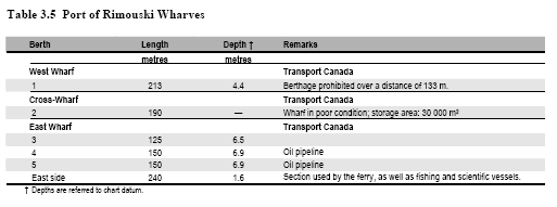
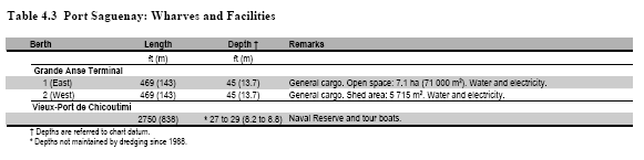
LIST OF LIGHTS, BUOYS AND FOG SIGNALS CORRECTIONS
ATLANTIC |
||||||||||
22 H4180 |
Ingalls Head Breakwater |
On outer end of breakwater. 44 39 41.9 66 45 16.6 |
Q |
G |
1s |
5.3 |
7 |
Cylindrical mast, green, white and green square daymark. 4 |
Operates at night only. Year round. Chart:4342 Edn 04/11 (F11-042) |
|
47 H4146.4 |
Leonardville Wharf |
Near outer end of wharf. 44 58 17.3 66 57 09.4 |
F |
R |
..... |
7.8 |
7 |
Cylindrical mast. 6.8 |
Operates at night only. Year round. Chart:4114 Edn 04/11 (F11-050) |
|
48 H4148 |
Fairhaven |
On outer end of wharf. 44 57 49.8 67 00 29.5 |
F |
R |
..... |
4.2 |
7 |
Cylindrical mast. 3.7 |
Operates at night only. Year round. Chart:4114 Edn 04/11 (F11-040) |
|
54 |
Bag Ledge |
44 59 59.5 66 56 26 |
Fl |
Y |
4s |
2.7 |
2 |
Cylindrical mast. 7 |
Operates at night only. Year round. Chart:4124 Edn 04/11 (F11-079) |
|
79 H4115 |
Roaring Bull |
On W. side of ledge. 45 02 22.6 66 48 46.2 |
Fl |
R |
4s |
4.5 |
3 |
Red cylindrical mast. 5.7 |
Operates at night only. Year round. Chart:4124 Edn 04/11 (F11-078) |
|
122 |
Belyeas Point |
On W. side of river. 45 22 41.4 66 12 57.8 |
Fl |
G |
5s |
12.7 |
5 |
White square tower, red upper portion. 11.9 |
Flash 1 s; eclipse 4 s. Operates at night only. Seasonal. Chart:4141 Edn 04/11 (F11-041) |
|
125 |
Oak Point |
On E. extremity of point, W. side of river. 45 30 26.7 66 04 49.1 |
LFl |
G |
10s |
15.5 |
8 |
White square tower, red upper portion. 14.1 |
Flash 2 s; eclipse 8 s. Operates at night only. Seasonal. Chart:4141 Edn 04/11 (F11-047) |
|
131.5 |
Gorhams Bluff |
On the bluff. 45 32 28.8 66 02 05 |
Fl |
R |
4s |
7.7 |
3 |
Triangular skeleton tower. 3.5 |
Operates at night only. Seasonal. Chart:4141 Edn 04/11 (F11-058) |
|
147 H4077 |
Black River |
On SW. point entrance to river. 45 15 27.4 65 48 39.6 |
Fl |
W |
4s |
13.9 |
6 |
Pipe swing pole. 6.8 |
Operates at night only. Year round. Chart:4010 Edn 04/11 (F11-049) |
|
173 H3954 |
Parrsboro Wharf |
SE. corner of wharf. 45 23 24.1 64 19 06.6 |
Fl |
R |
4s |
5.14 |
3 |
Pipe swing pole. 3.7 |
Operates at night only. Year round. Chart:4399 Edn 04/11 (F11-046) |
|
192 H3942 |
Halls Harbour |
On end of wharf. 45 12 06.6 64 37 11.8 |
Fl |
R |
4s |
5.8 |
7 |
Cylindrical mast, red and white triangular daymark, red triangle in centre. 5.6 |
Operates at night only. Year round. Chart:4010 Edn 04/11 (F11-044) |
|
230 H3864 |
Little River |
On outer end of wharf. 44 26 37.4 66 07 44.6 |
LFl |
G |
6s |
7.5 |
4 |
Cylindrical mast, green, white and green square daymark. 6.7 |
Flash 2s; eclipse 4 s. Operates at night only. Year round. Chart:4118 Edn 04/11 (F11-055) |
|
230.2 H3864.5 |
East Sandy Cove |
On outer end of wharf. 44 29 10.8 66 05 04.3 |
Fl |
R |
4s |
4.3 |
4 |
Pipe Swing Pole. 3.7 |
Operates at night only. Year round. Chart:4118 Edn 04/11 (F11-057) |
|
251 |
Lurcher Shoal bifurcation light buoy NM Racon -.- (K) X Band |
W. of Southwest Shoal. 43 48 57.2 66 29 58 |
Fl (2+1) |
R |
6s |
..... |
..... |
Red, green and red, marked "NM". |
Operates at night only. Year round. Chart:4243 Edn 04/11 (F11-020) |
|
281 H3815 |
The Sluice West |
W. side of rock. 43 40 13.1 66 00 53.2 |
Fl |
W |
4s |
4.5 |
..... |
Cylindrical mast. 3.6 |
Operates at night only. Year round. Chart:4244 Edn 04/11 (F11-063) |
|
282 H3816 |
The Sluice East |
E. side of rock. 43 40 12.1 66 00 48.2 |
Fl |
W |
4s |
4.5 |
..... |
Cylindrical mast, 3 reflective bands. 3.6 |
Operates at night only. Year round. Chart:4244 Edn 04/11 (F11-076) |
|
295.9 H3801 |
Gull Island |
43 39 37.6 65 54 55.3 |
Fl |
W |
4s |
8.6 |
..... |
Square skeleton tower. white and red horizontals bands. 6.1 |
Operates at night only. Year round. Chart:4244 Edn 04/11 (F11-027) |
|
315 H3796 |
Falls Point Wharf |
On wharf extension. 43 31 45.6 65 44 23.5 |
Fl |
G |
5s |
8.7 |
..... |
Cylindrical mast, square green, white and green daymark. 6.6 |
Flash 1 s; eclipse 4 s. Operates at night only. Year round. Chart:4210 Edn 04/11 (F11-062) |
|
316 H3788 |
Bear Point Wharf |
S. end of wharf. 43 29 10.1 65 39 19.6 |
Fl |
R |
4s |
4.7 |
..... |
Cylindrical mast, red and white triangular daymark, red triangle in centre. 3.6 |
Operates at night only. Year round. Chart:4210 Edn 04/11 (F11-059) |
|
318.5 H3787.2 |
Newellton West Breakwater |
NE. corner, new pier extension. 43 28 24.6 65 38 01.7 |
Fl |
R |
12s |
9.9 |
4 |
Square skeleton tower. 6.6 |
Flash 2 s; eclipse 10 s. Operates at night only. Year round. Chart:4210 Edn 04/11 (F11-061) |
|
323.5 H3785.4 |
Swims Point |
Outer end of wharf. 43 25 56.9 65 37 54.9 |
LFl |
G |
6s |
8 |
5 |
Cylindrical mast, green, white and green square daymark. 6.6 |
Flash 2 s; eclipse 4 s. Operates at night only. Year round. Chart:4210 Edn 04/11 (F11-054) |
|
329.5 H3784.4 |
Daniels Head |
End of rubble breakwater. 43 26 54.6 65 35 09.6 |
Fl |
G |
4s |
9.4 |
4 |
Square skeleton tower. 6.6 |
Operates at night only. Year round. Chart:4241 Edn 04/11 (F11-045) |
|
331.2 H3787.4 |
Stoney Island Outer Breakwater |
On outer end of breakwater. 43 28 06.4 65 33 56.1 |
Fl |
G |
3s |
9.6 |
..... |
Square skeleton tower, red, white and red rectangular daymark, green white and green square in center. 6.7 |
Flash 1 s; eclipse 2 s. Operates at night only. Year round. Chart:4241 Edn 04/11 (F11-060) |
|
388 H3746 |
Port Hebert |
On Shingle Point, E. side of harbour. 43 48 46.9 64 55 30.4 |
Fl |
R |
5s |
8.0 |
4 |
Skeleton mast. 6.6 |
Flash 1 s; eclipse 4 s. Operates at night only. Year round. Chart:4240 Edn 04/11 (F11-068) |
|
403 H3742.6 |
Hunts Landing |
On outer end of breakwater. 43 57 05.3 64 46 07.4 |
Iso |
R |
4s |
7.6 |
4 |
Skeleton tower, enclosed lower portion red, white and red rectangular daymark red triangle in center. 3.5 |
Operates at night only. Year round. Chart:4240 Edn 04/11 (F11-066) |
|
417.5 H3718 |
Cherry Cove |
On point of land between Little Harbour and Back Cove. 44 09 29.8 64 28 53.2 |
Iso |
G |
4s |
6.7 |
8 |
Cylindrical mast. 3.7 |
Operates at night only. Year round. Horn - Blast 3 s; sil. 27 s. Horn points 055º46'. Seasonal. Chart:4211 Edn 04/11 (F11-070) |
|
435 H3700 |
Feltzen South |
At end of breakwater. 44 19 47.6 64 16 49.7 |
Fl |
G |
6s |
6.1 |
4 |
Cylindrical mast. 3.6 |
Flash 1 s; eclipse 5 s. Operates at night only. Year round. Chart:4328 Edn 04/11 (F11-074) |
|
481 H3667 |
Northwest Cove Wharf |
On outer end of wharf. 44 32 01.2 64 01 24.9 |
LFl |
R |
6s |
4.6 |
4 |
Pipe swing pole. 3.7 |
Flash 2 s; eclipse 4 s Operates at night only. Year round. Chart:4386 Edn 04/11 (F11-065) |
|
486 H3661 |
Peggy's Cove Wharf |
On outer end of wharf. 44 29 36.4 63 54 59.6 |
Fl |
G |
3s |
4.5 |
4 |
Pipe swing pole, green, white and green square daymark. 3.7 |
Flash 1 s; eclipse 2 s Operates at night only. Year round. Chart:4386 Edn 04/11 (F11-051) |
|
487.5 H3659 |
Dover West |
On wharf. 44 29 34.7 63 52 05.4 |
LFl |
G |
6s |
5.2 |
4 |
Pipe swing pole. 3.7 |
Flash 2 s; eclipse 4 s Operates at night only. Year round. Chart:4386 Edn 04/11 (F11-080) |
|
489 H3657 |
East Dover Wharf |
On outer end of wharf. 44 29 44.5 63 50 41.6 |
LFl |
R |
6s |
4.5 |
4 |
Pipe swing pole, red and white triangular daymark, red triangle in centre. 3.7 |
Flash 2 s; eclipse 4 s Operates at night only. Year round. Chart:4386 Edn 04/11 (F11-048) |
|
492 H3655 |
Prospect Wharf |
On outer end of public wharf. 44 28 07.9 63 47 03.3 |
Fl |
G |
4s |
4.5 |
4 |
Pipe swing pole. 3.7 |
Flash 1 s; eclipse 3 s Operates at night only. Year round. Chart:4385 Edn 04/11 (F11-053) |
|
496.5 H3651.4 |
Lower Prospect |
On wharf. 44 27 03.4 63 43 32.1 |
Fl |
W |
4s |
4.5 |
4 |
Pipe swing pole. 3.7 |
Flash 1 s; eclipse 3 s Operates at night only. Year round. Chart:4385 Edn 04/11 (F11-056) |
|
499 H3651 |
Terence Bay Wharf |
On outer end of wharf. 44 28 04.4 63 42 52.2 |
LFl |
W |
6s |
4.7 |
4 |
Pipe swing pole. 3.7 |
Flash 2 s; eclipse 4 s Operates at night only. Year round. Chart:4385 Edn 04/11 (F11-052) |
|
522.1 H3605 |
Herring Cove Breakwater |
SE. corner of breakwater. 44 34 09.6 63 33 25.4 |
Fl |
R |
5s |
4 |
..... |
Pipe swing pole, red and white daymark red triangle in center. 3.5 |
Flash 1 s; eclipse 4 s. Operates at night only. Year round. Chart:4203 Edn 04/11 (F11-039) |
|
583 H3566 |
Owls Head Direction |
On extremity of head. 44 43 14.6 62 47 59.5 |
Fl |
W |
4s |
25.8 |
6 |
Skeleton mast, red. white and red triangular daymarks. 9.7 |
Operates at night only. Year round. Chart:4236 Edn 04/11 (F11-071) |
|
589 H3560 |
Popes Harbour |
On W. point of Harbour Island. 44 47 40.3 62 39 01.4 |
LFl |
R |
12s |
9.4 |
5 |
Skeleton tower, red and white rectangular daymark. 6.7 |
Flash 2 s; eclipse 10 s. Operates at night only. Year round. Chart:4236 Edn 04/11 (F11-038) |
|
612 H3530 |
Marie Joseph (Thrumcap Island) |
On Islet. 44 57 25.6 62 02 25.7 |
Fl |
R |
4s |
12.2 |
4 |
Square skeleton tower, red and white rectangular daymark, red triangle in center. 6.1 |
Operates at night only. Year round. Chart:4234 Edn 04/11 (F11-024) |
|
634 H3512 |
Fishermans Harbour |
W. extremity of Shingle beach on S. side of harbour. 45 06 42 61 40 41.1 |
Fl |
G |
4s |
7.1 |
7 |
Square skeleton tower, green, white and green daymark. 7.9 |
Operates at night only. Seasonal. Chart:4234 Edn 04/11 (G11-054) |
|
845.7 H857.5 845.8 H857.51 |
Briton Cove range |
|
46 26 41.2 60 27 38.7 290°59' 80.2m from front. |
F F |
Y Y |
..... ..... |
7.2 10.7 |
16 16 |
Square skeleton tower, white trapezoid daymark, red vertical stripe. 5 Square skeleton tower, white trapezoid daymark, red vertical stripe. 10.1 |
Visible in line of range. operates at night only. Seasonal. Visible in line of range. operates at night only. Seasonal. Chart:4367 Edn 04/11 (G11-055, 056) |
1637 |
Anse-à-Valleau light and bell buoy VALLEA |
Delete from list. Chart:4026 Edn 04/11 (Q11-040) |
||||||||
1685 H1860 |
Cap-Chat |
NE. point of cap, Gaspésie. 49 05 20.4 66 44 28 |
Fl |
W |
6s |
41.4 |
15 |
White square tower, red upper portion. 9.5 |
Flash 1 s; eclipse 5 s. Emergency light. Privately maintained by le Parc Récréotouristique du rocher Cap Chat. Year round. Chart:1236 Edn 04/11 (Q11-041) |
|
1734 H2074 1735 H2074.1 |
Port de Rimouski range Racon -. (N) X & S Band |
| | | | | | | | | | | | | |
S. of wharf. 48 28 06 68 31 06.1 178°23' 701.7m from front. |
Iso Iso |
R R |
1s 1s |
11.2 20.6 |
16 16 |
Square skeleton tower, orange daymark, black vertical stripe. 11.2 Square skeleton tower, orange daymark, black vertical stripe. 18.9 |
Visible in line of range. Emergency light. Year round. Visible in line of range. Emergency light. Year round. Chart:1236 Edn 04/11 (Q10-167, 168) |
1779 H2112 1779.1 1780 H2112.1 |
Pointe Noire, Saguenay range |
| | | | | | | | | | | | | |
On E. extremity of point. 48 07 23.9 69 43 00.4 273°05' 427.4m from front. |
F F F |
W G W |
..... ..... ..... |
29.1 28.8 43.5 |
22 6 22 |
Square skeleton tower, orange trapezoid daymark, black vertical stripe. 11.4 11.0 Skeleton tower, orange trapezoid daymark, black vertical stripe. 9.1 |
Visible in line of range. Emergency light. Year round. Visible from 077° through E. and S. to 257°. Visible in line of range. Emergency light. Year round. Chart:1203 Edn 04/11 |
INLAND WATERS |
||||||||||
24 |
Light buoy A38 |
45 21 37.2 73 50 29.6 |
Q |
R |
1s |
..... |
..... |
Red, marked "A38". |
Winter spar. Seasonal. Chart:1430 Edn 04/11(Q11-042) |
|

