
Archived information
The Standard on Web Usability replaces this content. This content is archived because Common Look and Feel 2.0 Standards have been rescinded.
Archived information is provided for reference, research or recordkeeping purposes. It is not subject to the Government of Canada Web Standards and has not been altered or updated since it was archived.
NOTICES TO MARINERS
PUBLICATION
EASTERN EDITION

Safety First, Service Always
Published Monthly by the
CANADIAN COAST GUARD
www.notmar.gc.ca/subscribe/
CONTENTS
| Section 1 | General and Safety Information |
| Section 2 | Chart Corrections |
| Section 3 | Radio Aids to Marine Navigation Corrections |
| Section 4 | Sailing Directions and Small Craft Guide Corrections |
| Section 5 | List of Lights, Buoys and Fog Signals Corrections |
Canadian Coast Guard Programs
Aids to Navigation and Waterways
Fisheries and Oceans Canada
Montreal, Quebec
H2Y 2E7
© Her Majesty the Queen in Right of Canada, 2016
DFO/2016-2002
Fs152-6E-PDF
ISSN 1719-7708
Disponible en français :
Publication des Avis aux navigateurs
Édition de l'Est
Édition mensuelle Nº09/2016
Fisheries and Oceans Canada
Official Publication of the Canadian Coast Guard
DFO/2018-2002
EXPLANATORY NOTES
Geographical positions refer directly to the graduations of the largest scale Canadian Hydrographic chart unless otherwise indicated.
Bearings refer to the true compass and are measured clockwise from 000° (North) clockwise to 359°; those relating to lights are from seaward.
Visibility of lights is that in clear weather.
Depths - The units used for soundings (metres, fathoms or feet) are stated in the title of each chart.
Elevations are normally given above Higher High Water, Large Tide unless otherwise indicated.
Distances may be calculated as follows:
1 nautical mile = 1,852 metres (6,076.1 feet)
1 statute mile = 1,609.3 metres (5,280 feet)
1 metre = 3.28 feet
Temporary & Preliminary Notices are indicated by a (T) or a (P) in Section 1, respectively. Please note that Nautical charts are not amended by the Canadian Hydrographic Service for Temporary (T) and Preliminary (P) Notices. It is recommended that mariners chart these corrections in pencil. The list of charts affected by Temporary and Preliminary Notices are revised and promulgated quarterly in Section 1 of the Monthly Edition.
Please note that, in addition to the temporary and preliminary changes normally advertised as (T) and (P) Notices, there are a few permanent changes to aids to navigation that have been advertised as Preliminary Notices to Mariners while charts are being updated for new editions.
Marine Information Report & Suggestion Sheet
Mariners are requested to notify the responsible authorities when new or suspected dangers to navigation are discovered, changes observed in aids to navigation or corrections to publications are seen
to be necessary. Such communications can be made using the Marine Information Report & Suggestion Sheet inserted on the last
page of each monthly edition of Notices to Mariners.
Canadian Hydrographic Service - Information Published in Section 2 of Notices to Mariners
Mariners are advised that only the most critical changes that directly affect safety to navigation are issued in Section 2 – Chart Corrections. This limitation
is required to ensure that charts remain as clear and easy to read as possible. As a result, mariners may see minor discrepancies of a
non-critical nature between information in official publications. For example, a small change in the nominal range or focal height of a light
may not result in the production of a chart correction in Notices to Mariners, but may result in a correction in the List of Lights, Buoys and
Fog Signals publication.
In case of discrepancy between information provided on CHS charts relating to aids to navigation, and the List of Lights, Buoys and Fog Signals publication, the latter shall be deemed as containing the most up-to-date information.
Canadian Nautical Charts & Publications
A source list of Canadian nautical charts and publications is published in Notice No. 14 of the Notices to Mariners Annual Edition 2018. The source supply and the prices
effective at the time of printing are listed. For current chart edition dates, please refer to the following website:
www.chs-shc.gc.ca/charts-cartes/paper-papier/index-eng.asp
CHART CORRECTIONS - SECTION 2
Corrections to nautical charts will be listed in numerical order by chart number. Each chart correction listed applies only to that particular chart. Related charts, if any, will have their own specific correction listed separately.
Users should also refer to CHS Chart 1: Symbols, Abbreviations and Terms for additional information pertaining to the correction of charts.
The illustration below describes the elements that will comprise a typical Section 2 chart correction:

The last correction number is identified with the LNM/D or Last Notice to Mariners Number / Date.
NOTICES TO MARINERS WEBSITE – MONTHLY EDITIONS, CHART CORRECTIONS, AND CHART PATCHES
The Notices to Mariners website allows users to access the monthly publications,
chart corrections, and chart patches.
Users can subscribe for free to the email notification service
to receive notifications when charts of interest are updated, including their patches, as well as when a new monthly edition becomes available online.
ADVISORY NOTICES TO SHIPPING (BROADCAST AND WRITTEN)
The Canadian Coast Guard is implementing a number of changes to the aids to navigation system in Canada.
These changes are advertised as Notices to Shipping (Broadcast and Written) by the Canadian Coast Guard, and are then followed up with Notices to Mariners, then charts are updated by hand correction, reprints or new editions.
Mariners are advised that all relevant Written Notices to Shipping should be kept until superseded by Notices to Mariners or through revised charts issued by the Canadian Hydrographic Service (CHS).
Written Notices to Shipping are available on the Canadian Coast Guard website at: www.ccg-gcc.gc.ca/eng/CCG/NOTSHIP.
The Canadian Hydrographic Service is reviewing the impact of these changes with the Canadian Coast Guard and together are preparing an action plan on the issuing of chart revisions.
For further information, contact your local Regional Notices to Shipping (NOTSHIP) issuing authorities.
Newfoundland
* Port aux Basques MCTS Centre
Canadian Coast Guard
49 Stadium Rd.
P.O. Box 99
Port aux Basques, NL A0M 1C0
Telephone: (709) 695-2168 or 1-800-563-9089
Facsimile: (709) 695-7784
Email: notshippax@dfo-mpo.gc.ca
Website: http://www.ccg-gcc.gc.ca/eng/CCG/Notship#nfld
Central & Arctic
* Prescott MCTS Centre
Canadian Coast Guard
401 King Street West
P.O. Box 1000
Prescott, ON K0E 1T0
“C” Series NOTSHIPs
Telephone: (613) 925-0666
Facsimile: (613) 925-4519
Email: CA.XCA-NotshipDesk@dfo-mpo.gc.ca
Website: http://www.ccg-gcc.gc.ca/eng/CCG/Notship-Home
Maritimes
* Sydney MCTS Centre
Canadian Coast Guard
1190 Westmount Road
Sydney, NS B1R 2J6
Telephone: (902) 564-7751 or 1-800-686-8676
Facsimile: (902) 564-7662
Email: notshipssyd@mar.dfo-mpo.gc.ca
Website: http://www.ccg-gcc.gc.ca/eng/CCG/Notship#maritime
Québec
* Les Escoumins MCTS Centre
Canadian Coast Guard
35, rue Otis
Les Escoumins, QC G0T 1K0
Telephone: (418) 233-2308
Facsimile: (418) 233-3299
Email: opsavis@dfo-mpo.gc.ca
Website: www.marinfo.gc.ca/en/avisecrits/index.asp
* Iqaluit MCTS Centre
Operational from approximately mid-May until late December.
Canadian Coast Guard
P.O. Box 189
Iqaluit, NU X0A 0H0
“A” Series NOTSHIPs
Telephone: (867) 979-5269
Facsimile: (867) 979-4264
Email: IqaNordreg@innav.gc.ca
Website: http://www.ccg-gcc.gc.ca/eng/CCG/Notship-Home
“H” Series NOTSHIPs
Telephone: (867) 979-0310
Facsimile: (867) 979-4264
Email: Iqamck01@innav.gc.ca
Website: http://www.ccg-gcc.gc.ca/eng/CCG/Notship-Home
* Service available in English and French.
Index
NUMERICAL INDEX OF CANADIAN CHARTS AFFECTED
| 1202 | 4011 | 4432 | 4980 |
| 1220 | 4015 | 4452 | 5051 |
| 1221 | 4016 | 4454 | 5352 |
| 1226 | 4047 | 4455 | 5365 |
| 1230 | 4049 | 4462 | 5390 |
| 1233 | 4255 | 4625 | 5391 |
| 1234 | 4277 | 4626 | 6242 |
| 1317 | 4278 | 4643 | 6341 |
| 1320 | 4302 | 4670 | 7082 |
| 1350 | 4328 | 4823 | 7646 |
| 1550 | 4335 | 4911 | 7736 |
| 2207 | 4385 | 4912 | 7760 |
| 2257 | 4386 | 4950 | 7776 |
| 2299 | 4396 | 4954 | 7777 |
| 3938 | 4416 | 4955 | 8005 |
| 4003 | 4428 | 4956 | 8010 |
| 4010 | 4429 | 4957 | U.S. 14832 |
SECTION 1 - GENERAL AND SAFETY INFORMATION
CANADIAN HYDROGRAPHIC SERVICE - ANNOUNCEMENT REGARDING CANADIAN HYDROGRAPHIC SERVICE CHART PATCHES
Colour Web Patches are free to the mariner, and given the quality of many printers, should reproduce well. They will be available in real time all around the world.
CHS welcomes your feedback on this service at shcinfo@dfo-mpo.gc.ca.
CANADIAN HYDROGRAPHIC SERVICE - CUMULATIVE CHART CORRECTIONS
The cumulative Notices to Mariners corrections for charts can now be accessed at http://www.notmar.com/corrections-en.php.
CANADIAN HYDROGRAPHIC SERVICE - Current chart edition dates
CHART EDITIONS
The three terms described below are used to indicate the publication status of Canadian charts.
NEW CHART - "NEWCHT"
The first publication of a Canadian chart embracing an area not previously charted to the scale shown, or embracing an area different from any existing Canadian chart.
NEW EDITION - "NEWEDT"
A new issue of an existing chart containing amendments essential to navigation in addition to those issued in Notices to Mariners and making existing editions obsolete.
REPRINTS
A new issue of the current edition of a chart incorporating no amendments of navigational significance other than those previously promulgated in Notices to Mariners. It may also contain amendments from other sources provided they are not essential to navigation. Previous printings of the current edition remain in force.
The current chart edition dates can be accessed at www.chs-shc.gc.ca/charts-cartes/paper-papier/index-eng.asp
CANADIAN HYDROGRAPHIC SERVICE - PRINT ON DEMAND CHARTS - CARE AND USE
Background
By providing nautical charts to the public, the goal of the Canadian Hydrographic Service (CHS) is to provide services for safe navigation in a fiscally responsible manner. As a result, CHS continues to expand its portfolio of nautical paper charts that are printed using Print On Demand (POD) technology. These charts are easily recognized by their whiter paper and the coloured logo of the Canadian Hydrographic Service. This new technology enables CHS to print charts in a more efficient manner while enhancing chart content through being able to quickly add new and important information. POD technology provides customers with up-to-date charts without the historical hand-drawn corrections or glued-on patches. Additionally, this technology eliminates out-of-stock situations which arise with the traditional printing and warehousing methods. In the event of a national emergency, CHS can respond to the appropriate authorities with best available information very quickly.
Care of Your POD Chart
CHS encourages its customers to handle the POD charts more carefully than the traditional lithographic charts. When plotting information on POD charts, use HB pencils and apply limited pressure. Testing has suggested that an Indian gum eraser is more effective than alternatives when used on the product. This eraser is also suitable for charts printed using lithographic processes.
CANADIAN HYDROGRAPHIC SERVICE - TRANSPORT CANADA NAVIGATION SAFETY - ECDIS
Mariners are advised that ECDIS may not display some isolated shoal depths when operating in "base or standard display" mode. Route planning and monitoring alarms for these shoal depths may not always be activated. To ensure safe navigation and to confirm that a planned route is clear of such dangers, mariners should visually inspect the planned route and any deviations from it using ECDIS configured to display "all data". The automated voyage planning check function should not be solely relied upon.
TRANSPORT CANADA - RESTRICTED SPEED AREA - ST. CLAIR AND DETROIT RIVER.
Since November 14, 2012 the restricted speed area currently in place as per the St. Clair and Detroit River Navigation Safety Regulation between the Detroit River light and Peche Island light is reduced in size by relocating the southern point of the restricted speed area from its current location at the Detroit River light to a new location at Bar Point light D33. (This notice refers to the previous one published in November 2012 with number *1103)
CANADIAN COAST GUARD PUBLICATION - RADIO AIDS TO MARINE NAVIGATION (ATLANTIC, ST. LAWRENCE, GREAT LAKES, LAKE WINNIPEG AND EASTERN ARCTIC) PUBLICATION - 2013 - The Commercial Public Correspondence Service.
Part I - Page 1 of 10
ADVANCE NOTICES
The Commercial Public Correspondence Service
Effective January 1, 2014, the following changes to the Canadian Coast Guard commercial public correspondence service, provided through select Marine Communications and Traffic Services centres, will be in effect: All long distance ship-shore callswill be administered through the regular telephone service provider as a collect call . Individuals intending to place shore-ship calls will be required to direct-dial the appropriate MCTS centre. MCTS centres providing a commercial public correspondence service are identified in RAMN, Part 2.
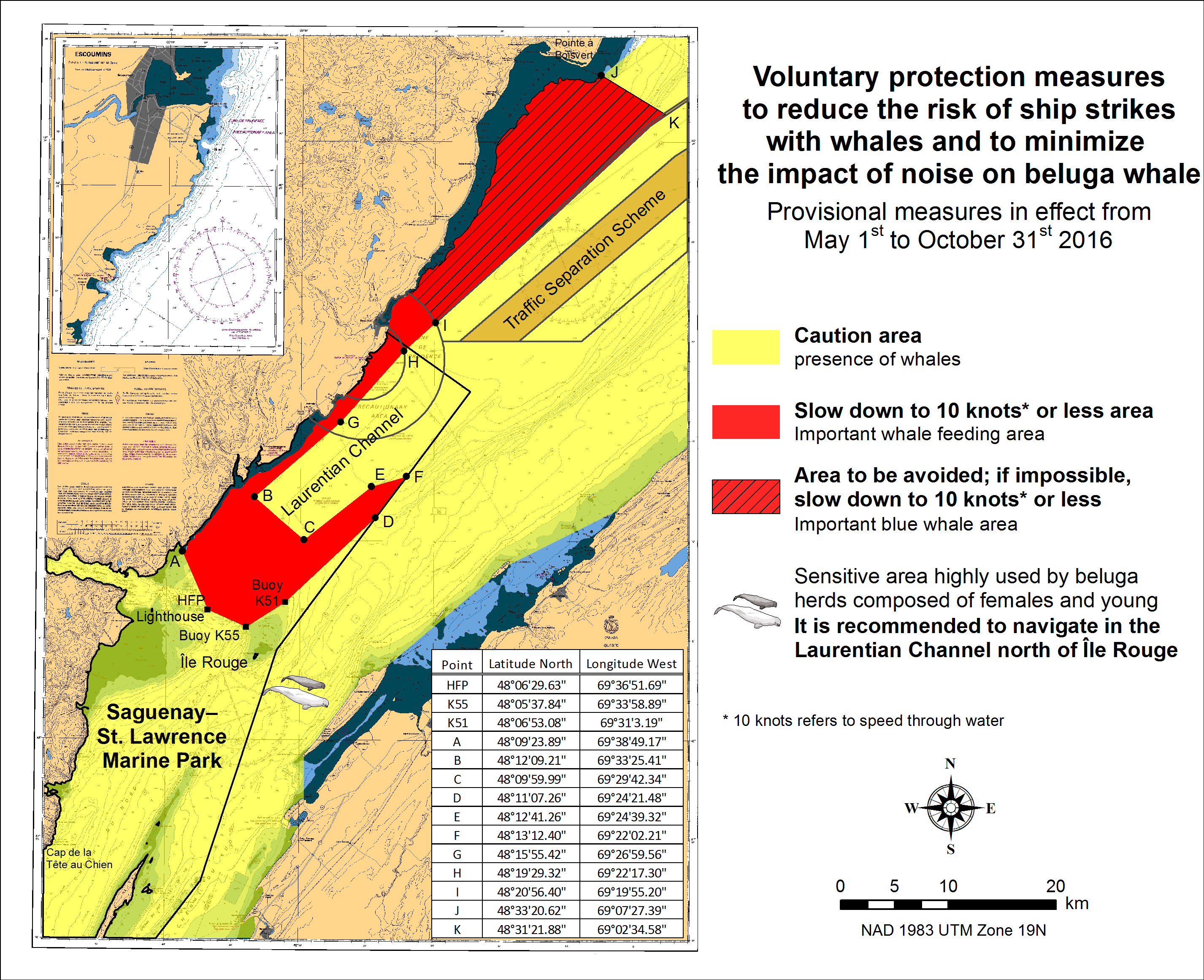
SAGUENAY-ST. LAWRENCE MARINE PARK AND SURROUNDING WATERS - WHALE PROTECTION.
The waters in and around the Saguenay-St. Lawrence Marine Park are well known for their resident threatened beluga population and the wide diversity of whales that migrate there to feed, particularly between April and November.
REGULATORY PROTECTION MEASURES
All whale species that are found in the St. Lawrence are protected under the Marine Mammal Regulations, pursuant to the Fisheries Act. Within the boundaries of the Marine Park, specific measures are set out in the Marine Activities in the Saguenay-St. Lawrence Marine Park Regulations, pursuant to the Act Establishing the Saguenay-St. Lawrence Marine Park. Any collision with a marine mammal within the Marine Park must immediately be reported to a park warden at 1-866-508-9888. For collisions that occur outside the Marine Park or for any situation involving a marine mammal that is dead or in trouble, contact the emergency network at 1-877-722-5346 or on channel 16.
For more information on the Saguenay-St. Lawrence Marine Park, see section 5C of the Annual Edition of the Notices to Mariners - April 2015 to March 2016.
VOLUNTARY PROTECTION MEASURES
Provisional measures in effect from May 1st to October 31st, 2016. See map below.
These measures apply to merchant vessels and cruise ships between Pointe à Boisvert and Cap de la Tête au Chien to prevent collisions with whales. These measures should only be taken when they will not jeopardize navigational safety.
Caution area (yellow area): To reduce the risk of collisions with whales that can be present anywhere in this area, heightened vigilance of navigators is critical. Posting a lookout is recommended in order to increase the chances of seeing the whales and thus taking necessary measures to avoid them. If bypassing the whales is not possible, slow down and wait for the animals to move away to a distance greater than 400 meters (0.215 nautical miles) before resuming original speed. It is more difficult to see the animals at night therefore increased caution is recommended.
Slow down to 10 knots or less area (red area): To reduce the risk of collisions with whales in this feeding area, it is recommended that vessels slow down to a maximum speed through the water of 10 knots and post a lookout. It is further recommended to remain in the Laurentian Channel to the north of Île Rouge to minimize the impact of noise in a sensitive area south of this island, which is highly frequented by herds of beluga whales composed of females and young.
Area to be avoided (hatched red area): To reduce noise and the risk of collisions with whales, vessels should avoid transiting through this area which is highly frequented by blue whales, an endangered species. If the area cannot be avoided, slow down to a speed through the water of 10 knots or less.
CANADIAN HYDROGRAPHIC SERVICE - ANNOUNCEMENT REGARDING TIDAL INFORMATION TABLES ON CHARTS.
ERRATUM : REFERENCE NOTICE 610(T)/2016
AMEND
Reference Chart: 8010
TO READ
Reference Chart: 4049
*REF: 303(T) STRAIT OF CANSO - 2016 AND 2017, REDUCED OPERATIONAL SEASON AMENDMENT OF OPERATIONAL PERIOD OF CANSO CANAL
Reference chart: 4302
Mariners are advised that, due to extensive maintenance requirements to the causeway swing bridge,
the Canso Canal will have a reduced operational season for the next two years. For the 2016 and 2017
navigation seasons, the Canso Canal will operate according to the following schedule:
2016 – April 14 to 07:30 local time November 1
2017 – 07:30 local time May 15 to 07:30 local time December 24
For further information, please contact:
Ovide Boudreau
Officer-in-Charge
Canso Canal
Telephone: (902) 625-1973
Email: Ovide.Boudreau@dfo-mpo.gc.ca
*901 CANADIAN HYDROGRAPHIC SERVICE - NAUTICAL CHARTS
| CHARTS | MAIN TITLE | SCALE | PUBLISHED | CAT # | PRICE |
|---|---|---|---|---|---|
| New Editions | |||||
| 3938 | Queens Sound to/à Seaforth Channel | 1:40000 | 15-APR-2016 | 2 | 20.00 |
| 4278 | Great Bras D'Or and/et St. Patricks Channel | 1:40000 | 26-AUG-2016 | 1 | 20.00 |
*902 CANADIAN HYDROGRAPHIC SERVICE - ELECTRONIC NAVIGATIONAL CHARTS
| NEW PRODUCTS | |
|---|---|
| S-57 ENC NUMBER | CHART TITLE |
| CA370440 | Bonilla Island to/à Edye Passage part 1 of 4 |
| CA370441 | Bonilla Island to/à Edye Passage Part 2 of 4 |
| CA370442 | Bonilla Island to/à Edye Passage Part 3 of 4 |
| CA370731 | Bonilla Island to/à Edye Passage Part 4 of 4 |
| CA376249 | Chetcamp to/à Cape Mabou |
| Withdrawn Products | |
| CA370298 | Bonilla Island to/à Edye Passage (Part 1 of 4) |
| CA370299 | Bonilla Island to/à Edye Passage (Part 2 of 4) |
| CA370300 | Bonilla Island to/à Edye Passage (Part 3 of 4) |
| CA370301 | Bonilla Island to/à Edye Passage (Part 4 of 4) |
*903 CANADIAN HYDROGRAPHIC SERVICE – RASTER DIGITAL CHARTS (BSB V4).
| CHARTS | MAIN TITLE | SCALE | PUBLISHED |
|---|---|---|---|
| New Charts | |||
| RM-3982 | Caamaño Sound to/à Whale Channel | 1:40000 | 30-OCT-2015 |
*904 TRANSPORT CANADA – SHIP SAFETY BULLETIN.
This is to notify you that a new Ship Safety Bulletin has recently been posted to
the Transport Canada website at:
www.tc.gc.ca/ssb-bsn/
To go online to view or download this bulletin, please click on the link below:
SSB#08/2016 - Regulations for Vessel Air Emissions: Sulphur in Fuel Content Verification Process
RDIMS#11568812
Sign yourself up for e-Bulletin to receive an e-mail notice each time a new Ship Safety Bulletin
is published on our Web site
Contact us at: marinesafety-securitemaritime@tc.gc.ca
or 1-855-859-3123 (Toll Free).
*905 TRANSPORT CANADA – SHIP SAFETY BULLETIN.
This is to notify you that a new Ship Safety Bulletin has recently been posted to
the Transport Canada website at:
www.tc.gc.ca/ssb-bsn/
To go online to view or download this bulletin, please click on the link below:
SSB#09/2016 - Interim Measure – Provisional Marine Medical Certificates
RDIMS#12228657
Sign yourself up for e-Bulletin to receive an e-mail notice each time a new Ship Safety Bulletin
is published on our Web site
Contact us at: marinesafety-securitemaritime@tc.gc.ca
or 1-855-859-3123 (Toll Free).
*906 NOTICES TO MARINERS ANNUAL EDITION. SECTION C - NOTICE 27A. AMENDMENTS.
Delete:
The Pre-arrival information (96-hour Notification - PAIR) made pursuant to the Marine Transportation Security Regulations, can now be found in Parts 3 and 4 of Radio Aids to Marine Navigation (RAMN). You can access the RAMN at the following web site: http://www.ccg-gcc.gc.ca/Communications-Marines/Home
Replace with:
Information concerning Pre-Arrival Information Report (PAIR) made pursuant to the Marine Transportation Security Regulations, can be found in Part 3 of the publication Radio Aids to Marine Navigation (RAMN).
Add to page 1, after 4) Anchorage areas (M):
5) Under keel Clearance
Add to page 5
5) Directives concerning Under Keel Clearance
In order to maximize the loading, operators and captains of wide-beam vessels and long vessels determine the minimum under keel clearance (UKC) by using the minimal authorized speed established at 7 knots in the UKC table. That constrains up bound vessels in Quebec-Montreal sector to transit during a long period with at minimum speed because of window passages restrictions. The speed between Quebec and Trois-Rivières can be influenced by the tide and the passage can be completed in 7 hours. But, Trois-Rivières and Montreal sector depends only on water levels; the vessel, not being able to go faster than 7 or 8 knots over the water (SOW) , corresponding to a speed of 5 knots over the ground (SOG) it will take 12 hours to complete the transit. Thus the vessel will cause a congestion of the system for a long period, that makes difficult to coordinate passages and safe meetings because they have to favor transits mainly during daylight and can anchor only in short time anchorages.
The hydraulic pressure on these very wide ships is important, at low speed they are less manoeuvrable and the response time is slower. When we need to push the ship to increase the pressure of water on the rudder to thwart a yaw, the ship inertia is so heavy it takes several minutes to have the wished effect. The operators and the captains should thus plan their transits at a minimum speed of 10 knots SOW , in order to reduce the transit time and allow the ship to be in the system for an acceptable and plannable time while favoring daylight passages and by ensuring a good maneuverability.
In order to ensure a safe conduct and allow the coordination of the transits in opposite directions of vessels in the Saint-Lawrence between Quebec City and Montreal, vessels with beam greater than 32.50 meters (Post-Panamax) shall:
-Conform with the under keel clearance calculation table as per notice to mariners 27C.
-When up bound to a destination upstream Quebec City, ensure to have an under keel clearance permitting a transit at a minimum speed of 10 knots on the water.
-When down bound from a locality upstream Quebec City ensure to have an under keel clearance permitting a transit at a minimum speed of 7 knots on the water
Notwithstanding the preceding, all vessels should be capable to reduce their speed if necessary in order to allow the coordination of the meetings between ships and conform to the voluntary measures of speed reduction.
*907 PUTULIK (HAT ISLAND) AND/ET WILKINS POINT – NEW EDITION OF CHART 7646.
Reference Chart: 7646
Insert this footnote to the release of chart 7646:
M’Clintock Bay has been removed from chart 7646 and replaced with Putulik (Hat Island).
MClintock Bay can be found on chart 7736.
*908 CAP DU PRINCE-DE-GALLES À/TO DAVIES ISLAND – NEW EDITION OF CHART 5365.
Reference Chart: 5365
This New Edition has been released to comply with the government of Canada’s official languages requirements. The information on this chart has only been updated for Notices to Mariners up to the date of publication.
*909 WAKEHAM BAY AND FISHER BAY ET LES APPROCHES/AND APPROACHES – NEW EDITION OF CHART 5390.
Reference Chart: 5390
This New Edition has been released to comply with the government of Canada’s official languages requirements. The information on this chart has only been updated for Notices to Mariners up to the date of publication.
*910 DOUGLAS HARBOUR ET LES APPROCHES/AND APPROACHES – NEW EDITION OF CHART 5391.
Reference Chart: 5391
This New Edition has been released to comply with the government of Canada’s official languages requirements. The information on this chart has only been updated for Notices to Mariners up to the date of publication.
*911 PAYNE BAY ET/AND RIVIÈRE ARNAUD (TUVALIK POINT À/TO ILE BASKING) – NEW EDITION OF CHART 5352.
Reference Chart: 5352
This New Edition has been released to comply with the government of Canada’s official languages requirements. The information on this chart has only been updated for Notices to Mariners up to the date of publication.
*912 CAPE RAY TO/À GARIA BAY – TWO HORIZONTALLY DRILLED STEEL CONDUITS.
Reference Chart: 4823
There are two horizontally drilled steel conduits, which extend above the sea floor:
Cape Ray East HDD (47° 36’ 55”N 059° 18’ 17.8”W)
Cape Ray West HDD(47° 36’ 56”N 059° 18’ 20.3”W)
These structures are part of the Maritime Link Project
(
http://www.emeranl.com/en/home/themaritimelink/infrastructure.aspx)
and provide the means to transition from buried subsea cables to land-based transmission.
*913 GREAT BRAS D'OR, ST. ANDREWS CHANNEL AND/ET ST. ANNS BAY – TWO HORIZONTALLY DRILLED STEEL CONDUITS.
Reference Chart: 4277
There are two horizontally drilled steel conduits, which extend above the sea floor:
Point Aconi East HDD (46° 19’ 59.7”N 060° 20’ 07”W)
Point Aconi West HDD (46° 19’ 59.7”N 060° 20’ 11.3”W)
These structures are part of the Maritime Link Project
(
http://www.emeranl.com/en/home/themaritimelink/infrastructure.aspx)
and provide the means to transition from buried subsea cables to land-based transmission.
*914 SOREL-TRACY À/TO OTTERBURN-PARK – PRIVATE UNLIT BUOY ESTABLISHED.
Reference Chart: 1350
The following private unlit buoy has been established:
The unlit buoy Saint-Charles-sur-Richelieu amont PRIV (LL 12823) (45° 41’ 19.2”N 073° 11’ 14.8”W)
(Q2016-124)
*915 WINNIPEG TO/AU LAKE WINNIPEG/LAC WINNIPEG – UNLIT BUOY PERMANENTLY ESTABLISHED.
Reference Chart: 6242
The following unlit buoy has been permanently established:
Red River Netley Cut Cautionary unlit buoy YNCN (LL 9801.5) (50° 18’ 40.0’’N 096° 50’ 03.3’’W)
(A2016-009)
*916 ÎLES DE LA MADELEINE – PRIVATE UNLIT BUOYS ESTABLISHED.
Reference Chart: 4950
The following private unlit buoys have been established:
The unlit buoy Havre-aux-Maisons North Center PRIV (LL 11606.5) (47° 21’ 34.8”N 061° 45’ 22.9”W)
The unlit buoy Havre-aux-Maisons South Center PRIV (LL 11606.6) (47° 21’ 27.1”N 061° 45’ 26.8”W)
(Q2016-128, 129)
*917 ST. ROCH AND/ET RASMUSSEN BASINS – PRIVATE LIGHT ESTABLISHED.
Reference Chart: 7760
Gjoa Haven Breakwater light (LL 4585.1) has been established in position 68° 37’ 13.4’’N 095° 52’ 41.7’’W.
It is a red flashing light [FlR 4S (PRIV)] with a height of 10.5 metres, and is located on the outer
end of the small craft breakwall.
Mariners are advised that the small craft breakwall is currently shown on electronic navigational
chart CA573391, but is not yet shown on chart 7760.
(NOTSHIP A115/12)
*918 LUNENBURG BAY – BUOYS DISCONTINUED.
Reference: Notice 205(T)/13 is cancelled (Chart 4328).
*919 FORTEAU BAY – FOG SIGNAL PERMANENTLY DISCONTINUED.
Reference: Notice 1206(T)/13 is cancelled (Chart 4670).
(N2016-002)
*920 NUNAKSUK ISLAND TO/À CALF COW AND/ET BULL ISLANDS – LIGHT AND RACON RECONSTRUCTED.
Reference: Notice 1208(T)/13 is cancelled (Chart 5051).
*921 ST. MARGARET'S BAY – AID TO NAVIGATION PERMANENTLY AMENDED.
Reference: Notice 507(P)/14 is cancelled (Chart 4386).
(F2016-047)
*922 ANNAPOLIS BASIN – BUOYS PERMANENTLY AMENDED.
Reference: Notice 709(P)/14 is cancelled (Chart 4396).
(F2015-026, 042)
*923 UPPER NIAGARA RIVER - GRAND ISLAND – BRIDGE MAINTENANCE WORK COMPLETED.
Reference: Notice 712(T)/14 is cancelled (U.S. Chart 14832).
*924 CHEBUCTO HEAD TO/À BETTY ISLAND – FOG SIGNAL PERMANENTLY DISCONTINUED.
Reference: Notice 202(P)/15 is cancelled (Chart 4385).
(F2016-032)
*925 ENTRÉE À/ENTRANCE TO MIRAMICHI RIVER – PROPOSITION TO AMEND SEVERAL AIDS TO NAVIGATION.
Reference: Notice 515(P)/15 is cancelled (Chart 4911).
*926 MIRAMICHI – FLOATING AIDS PERMANENTLY RELOCATED AND FIXED AIDS TO REMAIN YEAR ROUND.
Reference: Notice 516(P)/15 is cancelled (Chart 4912).
*927 BAY OF FUNDY / BAIE DE FUNDY (INNER PORTION / PARTIE INTÉRIEURE) – LIGHT PERMANENTLY DISCONTINUED.
Reference: Notice 1108(P)/15 is cancelled (Chart 4010).
(F2016-003)
SECTION 2 - CHART CORRECTIONS
1202 - Cap Éternité à Cap à l'Est - New Edition - 22-JUL-2011 - NAD 1983
| 02-SEP-2016 | LNM/D. 05-FEB-2016 | ||
| Affix | patch | 48°20′05.0″N 070°32′18.0″W | |
| Download Patch - http://www.chs-shc.gc.ca/patches/PA1202_20160329.pdf | |||
| DFO(6409410-01) | |||
1220 - Baie des Sept-Îles - New Edition - 11-MAY-2012 - NAD 1983
| 16-SEP-2016 | LNM/D. 14-AUG-2015 | ||
| Amend |
vertical clearance of 2 metres 6 decimetres, to read 2 metres 7 decimetres
(See Chart No. 1, D22) |
50°13′46.0″N 066°23′35.3″W | |
| This notice affects Electronic Navigational Chart: CA479006 | |||
| DFO(6409515-01) | |||
| Affix | patch | 50°14′05.0″N 066°35′55.0″W | |
| Download Patch - http://www.chs-shc.gc.ca/patches/PA1220_20160815.pdf | |||
| DFO(6409516-01) | |||
1221 - Pointe de Moisie à/to Île du Grand Caoui - New Edition - 27-FEB-2015 - NAD 1983
| 16-SEP-2016 | |||
| Affix | patch | 50°10′39.0″N 066°54′05.0″W | |
| Download Patch - http://www.chs-shc.gc.ca/patches/PA1221_20160329.pdf | |||
| DFO(6409414-01) | |||
| Amend |
vertical clearance of 4 metres 3 decimetres, to read 4 metres 4 decimetres
(See Chart No. 1, D22) |
50°16′11.1″N 066°27′53.5″W | |
| This notice affects Electronic Navigational Chart: CA379028 | |||
| DFO(6409431-01) | |||
| Amend |
vertical clearance of 2 metres 3 decimetres, to read 2 metres 5 decimetres
(See Chart No. 1, D22) |
50°06′39.6″N 066°42′00.9″W | |
| This notice affects Electronic Navigational Chart: CA379028 | |||
| DFO(6409431-02) | |||
| Amend |
vertical clearance of 4 metres 4 decimetres, to read 4 metres 5 decimetres
(See Chart No. 1, D22) |
50°06′20.4″N 066°42′42.2″W | |
| This notice affects Electronic Navigational Chart: CA379028 | |||
| DFO(6409431-03) | |||
| Amend |
vertical clearance of 2 metres 6 decimetres, to read 2 metres 7 decimetres
(See Chart No. 1, D22) |
50°13′36.2″N 066°23′41.5″W | |
| This notice affects Electronic Navigational Chart: CA379028 | |||
| DFO(6409431-04) | |||
1226 - Mouillages et Installations Portuaires/Anchorages and Harbour Installations - Haute Côte-Nord - New Edition - 19-FEB-2010 - NAD 1983
| 16-SEP-2016 | LNM/D. 19-AUG-2016 | ||
| Affix | patch | Below the chart title block | |
| Download Patch - http://www.chs-shc.gc.ca/patches/PA1226_20160413.pdf | |||
| DFO(6409413-01) | |||
1226 - Port-Cartier - New Edition - 19-FEB-2010 - NAD 1983
| 16-SEP-2016 | LNM/D. 19-AUG-2016 | ||
| Amend |
vertical clearance of 3 metres 2 decimetres to read 3 metres 3 decimetres
(See Chart No. 1, D22) |
50°01′01.4″N 066°52′08.6″W | |
| This notice affects Electronic Navigational Chart: CA379028, CA579047 | |||
| DFO(6409430-01) | |||
| Amend |
vertical clearance of 3 metres 4 decimetres, to read 3 metres 7 decimetres
(See Chart No. 1, D22) |
50°01′16.0″N 066°52′27.5″W | |
| This notice affects Electronic Navigational Chart: CA379028, CA579047 | |||
| DFO(6409430-02) | |||
1230 - Les Méchins - New Edition - 19-FEB-2010 - NAD 1983
| 30-SEP-2016 | LNM/D. 15-JUL-2016 | ||
| Delete |
depth of 0 metres 3 decimetres
(See Chart No. 1, I10) |
49°00′15.3″N 066°58′24.4″W | |
| This notice affects Electronic Navigational Chart: CA579056 | |||
| DFO(6409532-01) | |||
| Add |
depth of 0 metres 1 decimetre
(See Chart No. 1, I10) |
49°00′15.5″N 066°58′24.5″W | |
| This notice affects Electronic Navigational Chart: CA579056 | |||
| DFO(6409532-02) | |||
| Add |
drying height of 0 metres 1 decimetre
(See Chart No. 1, I15) |
49°00′14.8″N 066°58′23.3″W | |
| This notice affects Electronic Navigational Chart: CA579056 | |||
| DFO(6409532-03) | |||
1233 - Cap aux Oies à/to Sault-au-Cochon - New Edition - 11-MAY-2012 - NAD 1983
| 30-SEP-2016 | LNM/D. 19-AUG-2016 | ||
| Add |
depth of 4 metres 9 decimetres
(See Chart No. 1, I10) |
47°14′09.0″N 070°23′01.2″W | |
| This notice affects Electronic Navigational Chart: CA479021 | |||
| DFO(6409280-01) | |||
| Add |
depth of 0 metres 4 decimetres
(See Chart No. 1, I10) |
47°14′00.2″N 070°23′27.4″W | |
| This notice affects Electronic Navigational Chart: CA479021 | |||
| DFO(6409280-02) | |||
| Delete |
depth of 5 metres 2 decimetres
(See Chart No. 1, I10) |
47°13′56.6″N 070°23′18.2″W | |
| This notice affects Electronic Navigational Chart: CA479021 | |||
| DFO(6409280-03) | |||
| Add |
depth of 4 metres 5 decimetres
(See Chart No. 1, I10) |
47°13′56.7″N 070°23′18.0″W | |
| This notice affects Electronic Navigational Chart: CA479021 | |||
| DFO(6409280-04) | |||
| Add |
depth of 1 metre 9 decimetres
(See Chart No. 1, I10) |
47°13′51.2″N 070°23′36.5″W | |
| This notice affects Electronic Navigational Chart: CA479021 | |||
| DFO(6409280-05) | |||
| Add |
depth of 4 metres 6 decimetres
(See Chart No. 1, I10) |
47°13′42.4″N 070°23′25.4″W | |
| This notice affects Electronic Navigational Chart: CA479021 | |||
| DFO(6409280-06) | |||
| Add |
depth of 0 metres 1 decimetre
(See Chart No. 1, I10) |
47°13′38.9″N 070°23′56.4″W | |
| This notice affects Electronic Navigational Chart: CA479021 | |||
| DFO(6409280-07) | |||
| Add |
depth of 0 metres 4 decimetres
(See Chart No. 1, I10) |
47°13′25.8″N 070°24′02.9″W | |
| This notice affects Electronic Navigational Chart: CA479021 | |||
| DFO(6409280-08) | |||
| Add |
depth of 5 metres 0 decimetres
(See Chart No. 1, I10) |
47°13′06.6″N 070°23′46.8″W | |
| This notice affects Electronic Navigational Chart: CA479021 | |||
| DFO(6409280-09) | |||
| Add |
depth of 4 metres 9 decimetres
(See Chart No. 1, I10) |
47°12′58.5″N 070°23′49.5″W | |
| This notice affects Electronic Navigational Chart: CA479021 | |||
| DFO(6409280-10) | |||
| Add |
depth of 4 metres 3 decimetres
(See Chart No. 1, I10) |
47°13′20.7″N 070°23′19.1″W | |
| This notice affects Electronic Navigational Chart: CA479021 | |||
| DFO(6409280-11) | |||
| Add |
depth of 5 metres 0 decimetres
(See Chart No. 1, I10) |
47°13′53.5″N 070°22′45.0″W | |
|
This notice affects Electronic Navigational Chart: CA479021 |
|||
| DFO(6409280-12) | |||
1233 - Saint-Jean-Port-Joli - New Edition - 11-MAY-2012 - NAD 1983
| 30-SEP-2016 | LNM/D. 19-AUG-2016 | ||
| Add |
private light FIG (Priv)
(See Chart No. 1, P1) |
47°13′00.9″N 070°16′29.6″W | |
| This notice affects Electronic Navigational Chart: CA579024 | |||
| (Q2016114) LL(1875.8) DFO(6409514-01) | |||
| Delete |
port hand daybeacon
(See Chart No. 1, Qt) |
47°13′00.9″N 070°16′29.6″W | |
| This notice affects Electronic Navigational Chart: CA579024 | |||
| (Q2016115) DFO(6409518-01) | |||
| Add |
private light FIR (Priv)
(See Chart No. 1, P1) |
47°12′59.0″N 070°16′31.1″W | |
| This notice affects Electronic Navigational Chart: CA579024 | |||
| (Q2016116) LL(1875.9) DFO(6409519-01) | |||
| Delete |
starboard hand daybeacon
(See Chart No. 1, Qt) |
47°12′59.0″N 070°16′31.1″W | |
| This notice affects Electronic Navigational Chart: CA579024 | |||
| (Q2016117) DFO(6409520-01) | |||
1234 - Cap de la Tête au Chien au/to Cap aux Oies - New Edition - 04-NOV-2011 - NAD 1983
| 23-SEP-2016 | LNM/D. 26-AUG-2016 | ||
| Add |
obstruction, depth unknown, position approximate
(See Chart No. 1, K40, B7) |
47°57′03.4″N 069°32′30.0″W | |
| This notice affects Electronic Navigational Chart: CA379232 | |||
| DFO(6409544-01) | |||
1317 - Sault-au-Cochon à/to Québec - New Edition - 22-JUN-2012 - NAD 1983
| 16-SEP-2016 | LNM/D. 01-APR-2016 | ||
| Delete |
depth of 4 metres 1 decimetre
(See Chart No. 1, I10) |
46°57′26.4″N 070°40′43.5″W | |
| This notice affects Electronic Navigational Chart: CA479025 | |||
| DFO(6409471-01) | |||
| Add |
depth of 1 metre 9 decimetres
(See Chart No. 1, I10) |
46°57′25.5″N 070°40′44.7″W | |
| This notice affects Electronic Navigational Chart: CA479025 | |||
| DFO(6409471-02) | |||
| Add |
depth of 4 metres 6 decimetres
(See Chart No. 1, I10) |
46°56′25.4″N 070°43′56.4″W | |
| This notice affects Electronic Navigational Chart: CA479025 | |||
| DFO(6409471-03) | |||
| Add |
depth of 4 metres 7 decimetres
(See Chart No. 1, I10) |
46°56′23.2″N 070°44′28.8″W | |
| This notice affects Electronic Navigational Chart: CA479025 | |||
| DFO(6409471-04) | |||
| Add |
depth of 4 metres 7 decimetres
(See Chart No. 1, I10) |
46°56′12.7″N 070°45′10.2″W | |
| This notice affects Electronic Navigational Chart: CA479025 | |||
| DFO(6409471-05) | |||
| Add |
depth of 3 metres 9 decimetres
(See Chart No. 1, I10) |
46°55′49.6″N 070°45′34.9″W | |
| This notice affects Electronic Navigational Chart: CA479025 | |||
| DFO(6409471-06) | |||
| Delete |
depth of 5 metres 7 decimetres
(See Chart No. 1, I10) |
46°55′13.3″N 070°47′59.5″W | |
| This notice affects Electronic Navigational Chart: CA479025 | |||
| DFO(6409471-07) | |||
| Add |
depth of 4 metres 7 decimetres
(See Chart No. 1, I10) |
46°55′12.5″N 070°47′59.1″W | |
| This notice affects Electronic Navigational Chart: CA479025 | |||
| DFO(6409471-08) | |||
| Add |
depth of 4 metres 7 decimetres
(See Chart No. 1, I10) |
46°54′54.7″N 070°48′37.2″W | |
| This notice affects Electronic Navigational Chart: CA479025 | |||
| DFO(6409471-09) | |||
| Add |
depth of 5 metres 0 decimetres
(See Chart No. 1, I10) |
46°54′42.5″N 070°49′59.1″W | |
| This notice affects Electronic Navigational Chart: CA479025 | |||
| DFO(6409471-10) | |||
| Delete |
depth of 8 metres 8 decimetres
(See Chart No. 1, I10) |
47°00′46.2″N 070°55′35.6″W | |
| This notice affects Electronic Navigational Chart: CA479025 | |||
| DFO(6409486-05) | |||
| Add |
depth of 7 metres 8 decimetres
(See Chart No. 1, I10) |
47°00′46.2″N 070°55′38.2″W | |
| This notice affects Electronic Navigational Chart: CA479025 | |||
| DFO(6409486-06) | |||
| Add |
depth of 1 metre 0 decimetres
(See Chart No. 1, I10) |
47°01′29.6″N 070°53′32.4″W | |
| This notice affects Electronic Navigational Chart: CA479025 | |||
| DFO(6409486-07) | |||
| Add |
depth of 3 metres 7 decimetres
(See Chart No. 1, I10) |
47°01′48.1″N 070°53′15.8″W | |
| This notice affects Electronic Navigational Chart: CA479025 | |||
| DFO(6409486-08) | |||
| Add |
depth of 4 metres 7 decimetres
(See Chart No. 1, I10) |
47°01′50.2″N 070°52′02.3″W | |
| This notice affects Electronic Navigational Chart: CA479025 | |||
| DFO(6409486-09) | |||
| Add |
depth of 5 metres 4 decimetres
(See Chart No. 1, I10) |
47°02′17.7″N 070°49′10.6″W | |
| This notice affects Electronic Navigational Chart: CA479025 | |||
| DFO(6409486-10) | |||
| Delete |
depth of 10 metres 5 decimetres
(See Chart No. 1, I10) |
47°02′30.1″N 070°48′05.1″W | |
| This notice affects Electronic Navigational Chart: CA479025 | |||
| DFO(6409486-11) | |||
| Add |
depth of 5 metres 5 decimetres
(See Chart No. 1, I10) |
47°02′31.6″N 070°47′59.9″W | |
| This notice affects Electronic Navigational Chart: CA479025 | |||
| DFO(6409486-12) | |||
| Add |
depth of 7 metres 6 decimetres
(See Chart No. 1, I10) |
47°02′55.3″N 070°47′25.7″W | |
| This notice affects Electronic Navigational Chart: CA479025 | |||
| DFO(6409486-13) | |||
| Add |
depth of 9 metres 1 decimetre
(See Chart No. 1, I10) |
47°03′29.1″N 070°46′04.5″W | |
| This notice affects Electronic Navigational Chart: CA479025 | |||
| DFO(6409486-14) | |||
| Add |
depth of 7 metres 8 decimetres
(See Chart No. 1, I10) |
47°02′23.7″N 070°48′17.1″W | |
| This notice affects Electronic Navigational Chart: CA479025 | |||
| DFO(6409486-15) | |||
1317 - Continuation A - New Edition - 22-JUN-2012 - NAD 1983
| 16-SEP-2016 | LNM/D. 01-APR-2016 | ||
| Delete |
depth of 6 metres 4 decimetres
(See Chart No. 1, I10) |
46°59′23.1″N 070°58′08.9″W | |
| This notice affects Electronic Navigational Chart: CA479082 | |||
| DFO(6409486-01) | |||
| Add |
depth of 5 metres 9 decimetres
(See Chart No. 1, I10) |
46°59′22.6″N 070°58′10.1″W | |
| This notice affects Electronic Navigational Chart: CA479082 | |||
| DFO(6409486-02) | |||
| Delete |
depth of 8 metres 2 decimetres
(See Chart No. 1, I10) |
46°59′25.7″N 070°57′38.6″W | |
| This notice affects Electronic Navigational Chart: CA479082 | |||
| DFO(6409486-03) | |||
| Add |
depth of 7 metres 5 decimetres
(See Chart No. 1, I10) |
46°59′27.5″N 070°57′40.3″W | |
| This notice affects Electronic Navigational Chart: CA479082 | |||
| DFO(6409486-04) | |||
| Delete |
depth of 8 metres 8 decimetres
(See Chart No. 1, I10) |
47°00′46.2″N 070°55′35.6″W | |
| This notice affects Electronic Navigational Chart: CA479025 | |||
| DFO(6409486-05) | |||
| Add |
depth of 7 metres 8 decimetres
(See Chart No. 1, I10) |
47°00′46.2″N 070°55′38.2″W | |
| This notice affects Electronic Navigational Chart: CA479025 | |||
| DFO(6409486-06) | |||
| Add |
depth of 1 metre 0 decimetres
(See Chart No. 1, I10) |
47°01′29.6″N 070°53′32.4″W | |
| This notice affects Electronic Navigational Chart: CA479025 | |||
| DFO(6409486-07) | |||
| Add |
depth of 3 metres 7 decimetres
(See Chart No. 1, I10) |
47°01′48.1″N 070°53′15.8″W | |
| This notice affects Electronic Navigational Chart: CA479025 | |||
| DFO(6409486-08) | |||
| Add |
depth of 4 metres 7 decimetres
(See Chart No. 1, I10) |
47°01′50.2″N 070°52′02.3″W | |
| This notice affects Electronic Navigational Chart: CA479025 | |||
| DFO(6409486-09) | |||
1320 - Île du Bic au/to Cap de la Tête au Chien - New Chart - 26-AUG-2011 - NAD 1983
| 23-SEP-2016 | LNM/D. 19-AUG-2016 | ||
| Add |
obstruction, depth unknown, position approximate
(See Chart No. 1, K40, B7) |
47°57′03.4″N 069°32′30.0″W | |
| This notice affects Electronic Navigational Chart: CA379232 | |||
| DFO(6409544-01) | |||
1550 - Britannia Bay à/to Breckenridge - Sheet/Feuille 1 - New Edition - 27-MAY-2011 - NAD 1983
| 09-SEP-2016 | LNM/D. 23-MAY-2014 | ||
| Add |
obstruction, depth unknown, Rep (2016)
(See Chart No. 1, K40, I3.2) |
45°21′16.2″N 075°49′18.7″W | |
| DFO(6604234-01) | |||
2207 - Bay of Islands to/à Benjamin Islands (2207-1) - Sheet/Feuille 1 - New Chart - 27-JUL-2001 - NAD 1983
| 30-SEP-2016 | LNM/D. 26-SEP-2014 | ||
| Reposition |
starboard hand daybeacon
(See Chart No. 1, Qt) |
from 46°07′00.1″N 082°12′14.7″W
to 46°07′00.6″N 082°12′24.3″W |
|
| This notice affects Electronic Navigational Chart: CA473251 | |||
| (D2016006) DFO(6604221-01) | |||
2257 - Clapperton Island to/à John Island - New Edition - 11-JAN-2002 - NAD 1983
| 30-SEP-2016 | LNM/D. 27-MAR-2015 | ||
| Reposition |
starboard hand daybeacon
(See Chart No. 1, Qt) |
from 46°07′00.1″N 082°12′14.7″W
to 46°07′00.6″N 082°12′24.3″W |
|
| This notice affects Electronic Navigational Chart: CA473251 | |||
| (D2016006) DFO(6604221-01) | |||
2299 - Clapperton Island to/à Meldrum Bay - New Edition - 25-MAY-2001 - NAD 1983
| 30-SEP-2016 | LNM/D. 24-JUN-2016 | ||
| Reposition |
starboard hand daybeacon
(See Chart No. 1, Qt) |
from 46°07′00.1″N 082°12′14.7″W
to 46°07′00.6″N 082°12′24.3″W |
|
| This notice affects Electronic Navigational Chart: CA473251 | |||
| (D2016006) DFO(6604221-01) | |||
4003 - Cape Breton to / à Cape Cod - New Edition - 21-MAR-2003 - NAD 1983
| 02-SEP-2016 | LNM/D. 12-AUG-2016 | ||
| Reposition | private yellow ODAS/SADO lighted pillar Fl Y,
marked DMON MDR (See Chart No. 1, Q58) |
from 43°59′32.0″N 068°12′19.0″W
to 43°58′44.6″N 068°05′07.3″W |
|
| This notice affects Electronic Navigational Chart: CA276206 | |||
| (USCG:28/16) DFO(6307670-01) | |||
| Add | depth of 42 fathoms | 41°12′48.0″N 066°24′12.0″W | |
| This notice affects Electronic Navigational Chart: CA276367 | |||
| (NGA:30/2016) DFO(6307670-02) | |||
| Add | depth of 45 fathoms
(See Chart No. 1, I10) |
41°15′30.0″N 066°19′06.0″W | |
| This notice affects Electronic Navigational Chart: CA276367 | |||
| (NGA:30/2016) DFO(6307670-03) | |||
| Delete |
depth of 48 fathoms
(See Chart No. 1, I10) |
41°14′48.0″N 066°21′50.0″W | |
| DFO(6307670-06) | |||
4011 - Approaches to / Approches à Bay of Fundy / Baie de Fundy - New Edition - 03-JAN-2003 - NAD 1983
| 02-SEP-2016 | LNM/D. 13-MAY-2016 | ||
| Reposition |
private yellow ODAS/SADO lighted pillar Fl Y, marked DMON MDR
(See Chart No. 1, Q58) |
from 43°59′32.0″N 068°12′19.0″W
to 43°58′44.6″N 068°05′07.3″W |
|
| This notice affects Electronic Navigational Chart: CA276206 | |||
| (USCG:28/16) DFO(6307670-01) | |||
4015 - Sydney to / à Saint-Pierre - New Edition - 28-MAR-2003 - NAD 1983
| 02-SEP-2016 | LNM/D. 26-AUG-2016 | ||
| Delete |
legend Fog Sig against light
(See Chart No. 1, R1, R20) |
46°46′00.2″N 056°09′12.3″W | |
| This notice affects Electronic Navigational Chart: CA276091, CA376164 | |||
| DFO(6307665-01) | |||
4016 - Saint-Pierre to / à St. John's - New Edition - 06-JUN-2003 - NAD 1983
| 02-SEP-2016 | LNM/D. 06-MAY-2016 | ||
| Delete |
legend Fog Sig against light
(See Chart No. 1, R1, R20) |
46°45′56.2″N 056°09′24.4″W | |
| This notice affects Electronic Navigational Chart: CA276091, CA376164 | |||
| DFO(6307665-01) | |||
4047 - St. Pierre Bank/Banc de Saint-Pierre to/au Whale Bank/Banc de la Baleine - New Edition - 09-OCT-1998 - NAD 1983
| 02-SEP-2016 | LNM/D. 06-MAY-2016 | ||
| Delete |
legend Fog Sig against light
(See Chart No. 1, R1, R20) |
46°45′52.2″N 056°09′26.9″W | |
| This notice affects Electronic Navigational Chart: CA276091, CA376164 | |||
| DFO(6307665-01) | |||
4255 - Georges Bank/Banc de Georges - Eastern Portion/Partie Est - New Chart - 27-JUL-1990 - NAD 1983
| 02-SEP-2016 | LNM/D. 03-JUL-2015 | ||
| Add | depth of 77 metres | 41°12′48.0″N 066°24′12.0″W | |
| This notice affects Electronic Navigational Chart: CA276367 | |||
| (NGA:30/2016) DFO(6307670-02) | |||
| Add |
depth of 82 metres
(See Chart No. 1, I10) |
41°15′30.0″N 066°19′06.0″W | |
| This notice affects Electronic Navigational Chart: CA276367 | |||
| (NGA:30/2016) DFO(6307670-03) | |||
| Add |
depth of 79 metres
(See Chart No. 1, I10) |
41°13′48.0″N 066°22′18.0″W | |
| This notice affects Electronic Navigational Chart: CA276367 | |||
| (NGA:30/2016) DFO(6307670-05) | |||
4302 - Strait of Canso - New Chart - 28-SEP-2012 - NAD 1983
| 09-SEP-2016 | LNM/D. 05-FEB-2016 | ||
| Amend |
vertical clearance of 49 metres, to read 41 metres
(See Chart No. 1, D22) |
45°39′23.5″N 061°25′55.8″W | |
| This notice affects Electronic Navigational Chart: CA376242, CA476678 | |||
| DFO(6307686-01) | |||
4335 - Strait of Canso and Approaches/et les approches - New Edition - 04-JAN-2008 - NAD 1983
| 09-SEP-2016 | LNM/D. 05-FEB-2016 | ||
| Amend |
vertical clearance of 161 feet, to read 135 feet
(See Chart No. 1, D22) |
45°39′24.5″N 061°25′58.5″W | |
| This notice affects Electronic Navigational Chart: CA376242, CA476678 | |||
| DFO(6307686-01) | |||
4416 - Havre de Gaspé - New Edition - 12-JUN-2009 - NAD 1983
| 30-SEP-2016 | LNM/D. 01-JAN-2016 | ||
| Affix | patch | 48°51′45.0″N 064°24′00.0″W | |
| Download Patch - http://www.chs-shc.gc.ca/patches/PA4416_20160829.pdf | |||
| DFO(6409547-01) | |||
4428 - Havre de Natashquan et les approches/and Approaches - New Edition - 15-FEB-2008 - NAD 1983
| 09-SEP-2016 | LNM/D. 01-JUN-2012 | ||
| Affix | patch | 50°12′42.0″N 061°49′00.0″W | |
| Download Patch - http://www.chs-shc.gc.ca/patches/PA4428_20160329.pdf | |||
| DFO(6409416-01) | |||
| Amend |
vertical clearance of 1 metre 3 decimetres, to read 2 metres 1 decimetre
(See Chart No. 1, D22) |
50°11′17.0″N 061°49′25.8″W | |
| This notice affects Electronic Navigational Chart: CA379093, CA579098 | |||
| DFO(6409440-01) | |||
4429 - Havre Saint-Pierre et les approches/and Approaches - New Edition - 18-FEB-2011 - NAD 1983
| 02-SEP-2016 | LNM/D. 18-MAR-2016 | ||
| Affix | patch | 50°08′58.0″N 063°35′54.0″W | |
| Download Patch - http://www.chs-shc.gc.ca/patches/PA4429_20160329.pdf | |||
| DFO(6409418-01) | |||
4432 - Archipel de Mingan - New Edition - 11-MAR-2011 - NAD 1983
| 02-SEP-2016 | LNM/D. 18-MAR-2016 | ||
| Affix | patch | 50°22′30.9″N 063°54′36.5″W | |
| Download Patch - http://www.chs-shc.gc.ca/patches/PA4432_20160329.pdf | |||
| DFO(6409417-01) | |||
4452 - Baie de Kégaska - New Edition - 22-MAR-2013 - NAD 1983
| 09-SEP-2016 | LNM/D. 27-MAY-2016 | ||
| Amend |
vertical clearance of 6 metres 8 decimetres to read 6 metres 9 decimetres
(See Chart No. 1, D22) |
50°10′56.9″N 061°16′03.5″W | |
| This notice affects Electronic Navigational Chart: CA479138 | |||
| DFO(6409429-01) | |||
4454 - Pointe Curlew à/to Baie Washtawouka - New Edition - 16-NOV-2012 - NAD 1983
| 09-SEP-2016 | |||
| Affix | patch | 50°15′36.0″N 061°24′38.0″W | |
| Download Patch - http://www.chs-shc.gc.ca/patches/PA4454_20160330.pdf | |||
| DFO(6409420-01) | |||
| Amend |
vertical clearance of 1 metre 4 decimetres, to read 2 metres 1 decimetre
(See Chart No. 1, D22) |
50°11′10.3″N 061°49′14.6″W | |
| This notice affects Electronic Navigational Chart: CA379093, CA579098 | |||
| DFO(6409440-01) | |||
4455 - Baie Washtawouka à/to Baie Piashti - New Edition - 22-FEB-2013 - NAD 1983
| 09-SEP-2016 | LNM/D. 27-MAY-2016 | ||
| Affix | patch | 50°20′30.0″N 062°24′41.0″W | |
| Download Patch - http://www.chs-shc.gc.ca/patches/PA4455_20160329.pdf | |||
| DFO(6409419-01) | |||
| Amend |
vertical clearance of 7 metres 3 decimetres, to read 7 metres 4 decimetres
(See Chart No. 1, D22) |
50°16′48.5″N 062°21′06.3″W | |
| This notice affects Electronic Navigational Chart: CA379140 | |||
| DFO(6409441-01) | |||
4462 - St. George's Bay - New Edition - 07-MAR-2003 - NAD 1983
| 09-SEP-2016 | LNM/D. 05-FEB-2016 | ||
| Amend |
vertical clearance of 161 feet, to read 135 feet
(See Chart No. 1, D22) |
45°39′29.0″N 061°25′49.5″W | |
| This notice affects Electronic Navigational Chart: CA376242, CA476678 | |||
| DFO(6307686-01) | |||
4625 - Burin Peninsula to/à Saint-Pierre - New Edition - 24-JAN-2003 - NAD 1983
| 02-SEP-2016 | LNM/D. 06-MAY-2016 | ||
| Delete |
beacon with legend Fog Sig (2) 60s
(See Chart No. 1, R1) |
46°45′51.5″N 056°09′12.1″W | |
| This notice affects Electronic Navigational Chart: CA276091, CA376164 | |||
| DFO(6307665-01) | |||
4626 - Saint-Pierre and/et Miquelon (France) - New Edition - 24-JAN-2003 - NAD 1983
| 02-SEP-2016 | LNM/D. 06-MAY-2016 | ||
| Delete |
legend Fog Sig (2) 60s
(See Chart No. 1, R1) |
46°45′51.0″N 056°09′50.0″W | |
| This notice affects Electronic Navigational Chart: CA276091, CA376164 | |||
| DFO(6307665-01) | |||
4643 - Île Saint-Pierre (France) - New Edition - 28-MAR-2003 - NAD 1983
| 02-SEP-2016 | LNM/D. 12-FEB-2016 | ||
| Delete |
beacon with legend Fog Sig (2) 60s
(See Chart No. 1, R1) |
46°45′50.5″N 056°09′13.8″W | |
| This notice affects Electronic Navigational Chart: CA276091, CA376164 | |||
| DFO(6307665-01) | |||
4912 - Miramichi - New Edition - 27-JAN-2006 - NAD 1983
| 09-SEP-2016 | LNM/D. 04-MAR-2016 | |||
| Delete | depth of 6 metres
(See Chart No. 1, I10) |
47°08′04.7″N 065°11′17.3″W | ||
| This notice affects Electronic Navigational Chart: CA476125 | ||||
| DFO(6307552-02) | ||||
| Add | depth of 5 metres, 6 decimetres
(See Chart No. 1, I10) |
47°08′04.4″N 065°11′20.0″W | ||
| This notice affects Electronic Navigational Chart: CA476125 | ||||
| DFO(6307552-03) | ||||
4950 - Îles de la Madeleine - New Edition - 19-JUL-2013 - NAD 1983
| 30-SEP-2016 | LNM/D. 08-JAN-2016 | ||
| Reposition |
red starboard hand pillar lighted buoy Fl R, marked YE2
(See Chart No. 1, Qf) |
from 47°23′09.1″N 061°50′27.5″W
to 47°23′04.3″N 061°50′36.2″W |
|
| This notice affects Electronic Navigational Chart: CA379216, CA579046 | |||
| (Q2016118) LL(1494) DFO(6409521-01) | |||
4954 - Chenal du Havre de la Grande Entrée - New Edition - 18-MAR-2016 - NAD 1983
| 16-SEP-2016 | |||
| Delete |
depth of 1 metre 6 decimetres
(See Chart No. 1, I10) |
47°33′27.1″N 061°33′41.9″W | |
| This notice affects Electronic Navigational Chart: CA579084 | |||
| DFO(6409507-01) | |||
| Add |
depth of 0 metres 9 decimetres
(See Chart No. 1, I10) |
47°33′27.2″N 061°33′41.6″W | |
| This notice affects Electronic Navigational Chart: CA579084 | |||
| DFO(6409507-02) | |||
4955 - Havre-aux-Maisons - New Edition - 06-APR-2012 - NAD 1983
| 30-SEP-2016 | LNM/D. 15-JAN-2016 | ||
| Reposition |
red starboard hand conical lighted buoy Fl R, marked YE4
(See Chart No. 1, Qf) |
from 47°23′25.6″N 061°50′29.2″W
to 47°23′23.6″N 061°50′37.5″W |
|
| This notice affects Electronic Navigational Chart: CA579211 | |||
| (Q2016119) LL(1494.2) DFO(6409522-01) | |||
| Reposition |
red starboard hand conical lighted buoy Fl R, marked YE6
(See Chart No. 1, Qf) |
from 47°23′37.8″N 061°50′21.5″W
to 47°23′33.8″N 061°50′26.4″W |
|
| This notice affects Electronic Navigational Chart: CA579211 | |||
| (Q2016120) LL(1494.4) DFO(6409523-01) | |||
| Delete |
green port hand lighted can buoy Fl G, marked YE11
(See Chart No. 1, Qg) |
47°24′03.8″N 061°50′24.5″W | |
| This notice affects Electronic Navigational Chart: CA579211 | |||
| (Q2016122) LL(1494.9) DFO(6409524-01) | |||
| Add |
green port hand lighted can buoy Fl G, marked YE7
(See Chart No. 1, Qg) |
47°23′40.0″N 061°50′22.9″W | |
| This notice affects Electronic Navigational Chart: CA579211 | |||
| (Q2016121) LL(1494.45) DFO(6409528-01) | |||
4956 - Cap-aux-Meules - New Edition - 02-SEP-2011 - NAD 1983
| 30-SEP-2016 | LNM/D. 08-JUL-2016 | ||
| Reposition |
red starboard hand pillar lighted buoy Fl R, marked YE2
(See Chart No. 1, Qf) |
from 47°23′09.1″N 061°50′27.5″W
to 47°23′04.3″N 061°50′36.2″W |
|
| This notice affects Electronic Navigational Chart: CA379216, CA579046 | |||
| (Q2016118) LL(1494) DFO(6409521-01) | |||
| Add |
red starboard hand conical lighted buoy Fl R, marked YE4
(See Chart No. 1, Qf) |
47°23′23.6″N 061°50′37.5″W | |
| This notice affects Electronic Navigational Chart: CA579046 | |||
| (Q2016119) LL(1494.2) DFO(6409522-02) | |||
4957 - Havre-Aubert - New Edition - 02-JAN-2015 - NAD 1983
| 23-SEP-2016 | LNM/D. 12-FEB-2016 | ||
| Amend |
1,8m (2009) to read 1,2m (2015)
(See Chart No. 1, I22) |
47°14′03.0″N 061°49′46.0″W | |
| This notice affects Electronic Navigational Chart: CA579212 | |||
| DFO(6409525-01) | |||
| Delete |
depth of 6 metres 1 decimetre
(See Chart No. 1, I10) |
47°13′59.4″N 061°49′46.1″W | |
| This notice affects Electronic Navigational Chart: CA579212 | |||
| DFO(6409525-02) | |||
| Add |
depth of 4 metres 9 decimetres
(See Chart No. 1, I10) |
47°13′59.2″N 061°49′45.8″W | |
| This notice affects Electronic Navigational Chart: CA579212 | |||
| DFO(6409525-03) | |||
| Add |
depth of 4 metres 9 decimetres
(See Chart No. 1, I10) |
47°14′08.3″N 061°49′36.7″W | |
| This notice affects Electronic Navigational Chart: CA579212 | |||
| DFO(6409525-04) | |||
| Delete |
depth of 4 metres 9 decimetres
(See Chart No. 1, I10) |
47°14′14.2″N 061°49′31.4″W | |
| This notice affects Electronic Navigational Chart: CA579212 | |||
| DFO(6409525-05) | |||
| Add |
depth of 4 metres 6 decimetres
(See Chart No. 1, I10) |
47°14′14.3″N 061°49′31.6″W | |
| This notice affects Electronic Navigational Chart: CA579212 | |||
| DFO(6409525-06) | |||
| Add |
depth of 4 metres 7 decimetres
(See Chart No. 1, I10) |
47°14′15.3″N 061°49′29.9″W | |
| This notice affects Electronic Navigational Chart: CA579212 | |||
| DFO(6409525-07) | |||
| Add |
depth of 4 metres 8 decimetres
(See Chart No. 1, I10) |
47°14′17.2″N 061°49′28.0″W | |
| This notice affects Electronic Navigational Chart: CA579212 | |||
| DFO(6409525-08) | |||
| Delete |
depth of 4 metres 8 decimetres
(See Chart No. 1, I10) |
47°14′00.1″N 061°49′44.5″W | |
| This notice affects Electronic Navigational Chart: CA579212 | |||
| DFO(6409525-09) | |||
| Add |
depth of 4 metres 4 decimetres
(See Chart No. 1, I10) |
47°14′00.6″N 061°49′44.3″W | |
| This notice affects Electronic Navigational Chart: CA579212 | |||
| DFO(6409525-10) | |||
4980 - Quai / Wharf Blanc-Sablon - New Edition - 21-OCT-2011 - NAD 1983
| 16-SEP-2016 | |||
| Delete |
depth of 3 metres 8 decimetres
(See Chart No. 1, I10) |
51°24′57.1″N 057°09′02.7″W | |
| This notice affects Electronic Navigational Chart: CA579096 | |||
| DFO(6409449-01) | |||
| Add |
depth of 2 metres 9 decimetres
(See Chart No. 1, I10) |
51°24′57.1″N 057°09′02.8″W | |
| This notice affects Electronic Navigational Chart: CA579096 | |||
| DFO(6409449-02) | |||
| Delete |
depth of 5 metres 8 decimetres
(See Chart No. 1, I10) |
51°24′53.8″N 057°09′02.4″W | |
| This notice affects Electronic Navigational Chart: CA579096 | |||
| DFO(6409449-03) | |||
| Add |
depth of 5 metres 0 decimetres
(See Chart No. 1, I10) |
51°24′53.9″N 057°09′02.6″W | |
| This notice affects Electronic Navigational Chart: CA579096 | |||
| DFO(6409449-04) | |||
6341 - Great Slave Lake/Grand lac des Esclaves, Eastern Portion/Partie est - Sheet/Feuille 1 - New Edition - 16-JAN-2004 - Unknown
| 30-SEP-2016 | LNM/D. 28-NOV-2014 | ||
| Add |
obstruction, depth unknown, Rep (2016)
(See Chart No. 1, K41, I3.2) |
62°24′19.0″N 110°49′45.5″W | |
| DFO(6604236-01) | |||
7082 - Cape Baring to/à Cambridge Bay - New Edition - 20-FEB-2004 - Unknown
| 09-SEP-2016 | LNM/D. 07-JUN-2013 | ||
| Delete |
aero light and ″Aero RC″
(See Chart No. 1, P60, SI) |
68°28′54.0″N 113°12′39.0″W | |
| DFO(6604227-01) | |||
7776 - Dolphin and Union Strait - New Edition - 30-MAY-1997 - NAD 1983
| 09-SEP-2016 | LNM/D. 21-AUG-2015 | ||
| Delete |
aero light and ″Aero RC″
(See Chart No. 1, P60, SI) |
68°28′43.0″N 113°13′39.5″W | |
| DFO(6604227-01) | |||
7777 - Coronation Gulf Western Portion/Partie Ouest - New Edition - 15-MAY-2015 - WGS84
| 09-SEP-2016 | |||
| Delete |
aero light and ″Aero RC″
(See Chart No. 1, P60, SI) |
68°28′43.0″N 113°13′38.5″W | |
| DFO(6604227-01) | |||
8005 - Georges Bank - New Edition - 20-JUN-2003 - NAD 1983
| 02-SEP-2016 | LNM/D. 12-AUG-2016 | ||
| Add | depth of 42 fathoms | 41°12′48.0″N 066°24′12.0″W | |
| This notice affects Electronic Navigational Chart: CA276367 | |||
| (NGA:30/2016) DFO(6307670-02) | |||
| Add |
depth of 45 fathoms
(See Chart No. 1, I10) |
41°15′30.0″N 066°19′06.0″W | |
| This notice affects Electronic Navigational Chart: CA276367 | |||
| (NGA:30/2016) DFO(6307670-03) | |||
| Delete |
depth of 57 fathoms
(See Chart No. 1, I10) |
41°14′48.0″N 066°18′54.0″W | |
| (NGA:30/2016) DFO(6307670-04) | |||
SECTION 3 - RADIO AIDS TO MARINE NAVIGATION CORRECTIONS
*929 RADIO AIDS TO MARINE NAVIGATION 2016, (ATLANTIC, ST. LAWRENCE, GREAT LAKES, LAKE WINNIPEG AND ARCTIC).
PART 4 - Page 64
MODIFY THE FOLLOWING PARAGRAPHS:
4.3.8.6 Quarantine Messages
- In the following circumstances only, the person in charge of a vessel shall, by radio (via the nearest MCTS Centre), telephone or email, at least 24 hours prior to the vessel’s estimated time of arrival at its port of destination, notify or cause the notification of a quarantine officer at the quarantine station designated in paragraph (3) for that port of the occurrence:
- For the purposes of paragraph (1), the quarantine station for vessels bound for
- a port in the Province of Nova Scotia, New Brunswick, Prince Edward Island, or Newfoundland is the Halifax Nova Scotia Quarantine Station at 902-873-7659 (24 hour phone line) or by email at quarantineeast@phac-aspc.gc.ca if notification is 48 hours or greater prior to arrival;
- a port in the Province of Québec or any Canadian port via the St. Lawrence River, is the Montréal Québec Quarantine Station at 514-229-2561 (24 hour phone line) or by email at quarantineeast@phac-aspc.gc.ca if notification is 48 hours or greater prior to arrival;
- a port in the Province of Ontario or a port in the Nunavut Territories, is the Toronto, Ontario Quarantine Station at 416-315-5039 (24 hour phone line) or by email at quarantineeast@phac-aspc.gc.ca if notification is 48 hours or greater prior to arrival;
- a port on Hudson Bay is the Calgary Alberta Quarantine Station at 403-221-3067 (24 hour phone line) or by email at quarantinewest@phac-aspc.gc.ca if notification is 48 hours or greater prior to arrival;
- a port in the province of British Columbia, a port in the Yukon Territories or a port in the Northwest Territories, is the Vancouver British Columbia Quarantine Station at 604-317-1720 (24 hour phone line) or by email at quarantinewest@phac-aspc.gc.ca if notification is 48 hours or greater prior to arrival.
SECTION 4 - SAILING DIRECTIONS AND SMALL CRAFT GUIDE CORRECTIONS
ATL 106 — Gulf of Maine and Bay of Fundy, First Edition, 2001 —
Chapter 1 — Paragraph 102
Delete: Fairway light and bell
Replace by: South Cardinal light
(A2016-006.11)
Chapter 2 — Paragraph 22
Delete: “A light (247) … NW of Port Maitland.”
Replace by: A light (247) is shown from a skeleton tower having a green and white rectangular daymark, at the outer
end of the east breakwater. A light (250.1) is shown from a mast having a red and white triangular daymark,
on the outer end of the west breakwater. Fairway light buoy NU (246) is moored 0.7 mile NW of Port Maitland.
(A2016-006.12)
Chapter 2 — Paragraph 23, after “Bifurcation light”
Delete: and whistle
(A2016-006.13)
ATL 108 — Gulf of St. Lawrence (Southwest Portion), First Edition, 2006 —
Chapter 1 — Paragraph 42
Delete: 161 feet (49.1 m)
Replace by: 134 feet (41 m)
(A2016-008.10)
Chapter 2 — In the vicinity of paragraph 38
Replace the GRANDE-ENTRÉE diagram with the new one provided in Section 4 of this Monthly Edition.
https://www.notmar.gc.ca/publications/monthly-mensuel/images/092016-east-est-sec4-grande-entree-atl108.pdf
(Q2016-046.1)
Chapter 2 — Paragraph 77, after “offering a depth of”
Delete: 5.4 m (2009)
Replace by: 5.4 m (2015)
(Q2016-049.1)
Chapter 2 — Paragraph 77, after “A small basin with a depth of”
Delete: 1.8 m (2003)
Replace by: 1.2 m (2015)
(Q2016-049.2)
Chapter 2 — In the vicinity of paragraph 93
Replace the L’ANSE-À-LA-CABANE diagram with the new one provided in Section 4 of this Monthly Edition.
https://www.notmar.gc.ca/publications/monthly-mensuel/images/092016-east-est-sec4-lanse-a-la-cabane-atl108.pdf
(Q2016-026.1)
ATL 109 — Gulf of St. Lawrence (Northeast Portion), First Edition, 2006 —
Chapter 1 — Paragraph 182, after “berth length of 62 m (203 ft) with depths of”
Delete: 5.8 to 7.4 m (19 to 24 ft)
Replace by: 5.0 to 7.4 m (16 to 24 ft)
(Q2016-031.1)
Chapter 1 — Paragraph 182, after “fishermen’s wharf, with a”
Delete: depth of 3.7 m (12 ft)
Replace by: least depth of 2.9 m (10 ft)
(Q2016-031.2)
ATL 111 — St. Lawrence River — Île Verte to Québec and Fjord du Saguenay, Third Edition, 2007 —
Chapter 3 — Paragraph 38, after “wharf with depths alongside of”
Delete: 9.5 to 9.8 m
Replace by: 9.0 to 9.8 m
(Q2016-035.1)
Chapter 3 — Paragraph 65
Delete: Parts of the ruins are submerged.
(Q2016-043.1)
Chapter 3 — After paragraph 65
Insert: 65.1 A private light is at the outer end of the jetty.
(Q2016-043.2)
Chapter 3 — Adjacent to paragraph 65.1, add a light pictograph.
(Q2016-043.3)
SECTION 5 - LIST OF LIGHTS, BUOYS AND FOG SIGNALS CORRECTIONS
Newfoundland
| No. | Name | Position ----- Latitude N. Longitude W. |
Light Characteristics |
Focal Height in m. above water |
Nominal Range |
Description ----- Height in meters above ground |
Remarks ----- Fog Signals |
|||
|---|---|---|---|---|---|---|---|---|---|---|
| 238.1 | Gull Rock - light buoy KU1 | Griquet Hr Entrance. 51 31 54.7 055 26 51.2 |
Fl | G | 4s | ..... | ..... | Green spar, marked "KU1". |
Seasonal. Chart:4020 Edn 09/16 (N16-017) |
|
| 360.1 | Harbour Rock - light buoy DPU1 | 49 36 46.8 054 42 07.2 |
Fl | G | 4s | ..... | ..... | Green spar, marked "DPU1" | Seasonal. Chart:4863 Éd 09/16 (N16-041) |
|
| 360.2 | Shiphouse Rock - light buoy DPU2 | 49 36 48.6 054 42 01.8 |
Fl | R | 4s | ..... | ..... | Red spar, marked "DPU2". | Seasonal. Chart: 4863 Edn 09/16 (N16-042) |
|
| 376.1 | Cobbs Arm - light buoy DCB1 | 49 37 13.8 054 33 48.0 |
Fl | G | 4s | ..... | ..... | Green spar, marked "DCB1". | Seasonal. Chart: 4862 Edn 09/16 (N16-040) |
|
Atlantic
| No. | Name | Position ----- Latitude N. Longitude W. |
Light Characteristics |
Focal Height in m. above water |
Nominal Range |
Description ----- Height in meters above ground |
Remarks ----- Fog Signals |
|||
|---|---|---|---|---|---|---|---|---|---|---|
| 261 H3822 |
Ships Stern | On N. end of Ships Stern. 43 48 31.7 066 08 45.9 |
Fl | W | 4s | ..... | 4 | Pipe swing pole. 3.5 |
Year round. Chart: 4245 Edn 09/16 (F16-044) |
|
| 345 H3779 |
Port Latour Harbour | On Whale Back Rock. 43 29 34.0 065 26 58.8 |
Fl | G | 4s | 5.5 | 2 | Cylindrical mast, green, white and black square daymark.
3.8 |
Year round. Chart: 4241 Edn 09/16 (F16-050) |
|
| 1111.1 H1329 |
Pointe-du-Chêne | On outer end of breakwater. 46 14 29.2 064 31 40.4 |
Fl | R | 4s | 6.0 | 4 | Cylindrical mast, red triangular daymark. 3.5 |
Flash 1s; eclipse 3s. Seasonal. Chart : 4909 Edn 09/16 (G16-121) |
|
| 1314.1 H1582.4 |
Middle Caraquet, East Wharf. | 47 48 14.3 064 52 22.6 |
Fl | G | 4s | 4.3 | 4 | Pipe swing pole. | Seasonal. Chart:4920 Edn 09/16 (G16-122) |
|
| 1376 H1674 |
St. Godefroi FQ | On outer end of wharf. 48 04 23.4 065 06 52.1 |
Fl | R | 6s | 7.9 | 5 | Square skeleton tower. 6.5 |
Flash 1s; eclipse 5s. Seasonal. Chart:4486 Edn 09/16 (Q16-137) |
|
| 1379.5 | Port Daniel Est FR | On outer end of breakwater. 48 10 54.8 064 57 42.0 |
Iso | R | 2s | 4.0 | 3 | Cylindrical mast. 2.3 |
Seasonal.
Chart:4921 Edn 09/16 (Q16-138) |
|
| 1401.3 | Sainte-Thérèse de Gaspé, brise-lames Nord FR | On outer end of breakwater. 48 24 51.7 064 23 34.6 |
Iso | R | 2s | 3.1 | 3 | Mast. 2.2 |
Seasonal. Chart:4921 Edn 09/16 (Q16-136) |
|
| 1401.5 H1715 |
Sainte-Thérèse de Gaspé FR | On outer end of breakwater. 48 24 50.5 064 23 32.4 |
Iso | G | 4s | ..... | ..... | Green spar, marked "JN3". | Seasonal.
Chart:N/A Edn 08/16 (G16-115) |
|
| 1410 | Mal-Bay FQ | On the wharf. 48 37 12.3 064 11 57.3 |
Fl | G | 6s | 9.2 | ..... | Pipe swing pole. 7.8 |
Flash 1s; eclipse 5s. Seasonal. Chart:4921 Edn 09/16 (Q16-135) |
|
| 1494 | Havre-aux-Maisons Entrance - light buoy YE2 | Entrance to channel. 47 23 04.3 061 50 36.2 |
Fl | R | 4s | ..... | ..... | Red, marked "YE2". | Seasonal. Chart : 4950 Edn 09/16 (Q16-118) |
|
| 1494.2 | Havre-aux-Maisons - light buoy YE4 | 47 23 23.6 061 50 37.5 |
Fl | R | 4s | ..... | ..... | Red, marked "YE4". | Seasonal.
Chart:4955 Edn 09/16 (Q16-119) |
|
| 1494.4 | Havre-aux-Maisons - light buoy YE6 | 47 23 33.9 061 50 26.4 |
Fl | R | 4s | ..... | ..... | Red, marked "YE6". | Seasonal. Chart: 4955 Edn 09/16(Q16-120) |
|
| 1494.45 | Havre-aux-Maisons - light buoy YE7 | 47 23 40.0 061 50 22.9 |
Fl | G | 4s | ..... | ..... | Green, marked "YE7". | Seasonal. Chart:4955 Edn 09/16 (Q16-121) |
|
| 1494.9 | Havre-aux-Maisons - light buoy YE11 | Delete from list.
Chart:4955 Edn 09/16 (Q16-122) |
||||||||
| 1875.8 | Saint-Jean-Port-Joli FR | On northern end of breakwater. 47 13 00.9 070 16 29.6 |
Fl | G | 4s | ..... | ..... | Green, white and black square daymark. | Privately maintained. Year round. Chart: 1233 Edn 09/16 (Q16-114) |
|
| 1875.9 |
Saint-Jean-Port-Joli FR | On southern end of breakwater. 47 12 59.0 070 16 31.1 |
Fl | R | 4s | ..... | ..... | Red and white triangular daymark, red triangle in center. | Privately maintained. Year round. Chart: 1233 Edn 09/16 (Q16-116) |
|
Inland Waters
| No. | Name | Position ----- Latitude N. Longitude W. |
Light Characteristics |
Focal Height in m. above water |
Nominal Range |
Description ----- Height in meters above ground |
Remarks ----- Fog Signals |
|||
|---|---|---|---|---|---|---|---|---|---|---|
| 1589 | Matheson Island Landing | Delete from list. Chart:6267 Edn 09/16 (A16-010) |
||||||||
| 1597 | Dowling Reef - light buoy DM2 | SE. from reef. 51 59 35.9 097 05 41.0 |
Fl | R | 4s | ..... | ..... | Red spar, marked "DM2". | Seasonal. Chart: 6267 Edn 09/16 (A16-014) |
|
CANADIAN COAST GUARD - MARINE INFORMATION REPORT AND SUGGESTION SHEET
Name of Ship or Sender:..................................................................... Date:....................................
Address of Sender:..........................................................................................................................
Street # Street Name
Town / City:.............................. Prov / State:....................... Postal Code / Zip Code: ........................
Tel / Fax / E-mail address of sender (if appropriate):............................................................................
Observation Date:............................................. Time (UTC): ...........................................................
Geographical Position:......................................................................................................................
Coordinate Position: Lat: ............................................... Long:.........................................................
Position Method: DGPS GPS with WAAS GPS Radar Other
Horizontal Datum Used: WGS 84 NAD 27 Other
Estimated Position Accuracy:............................................................................................................
Chart #:............................................................ Datum: NAD 27 NAD 83
Chart Edition:.................................................... Last Correction applied:............................................
Publications affected: (Quote edition and page number):.....................................................................
*Full details (Attach additional sheets as necessary):...........................................................................
Mariners are requested to notify the responsible authorities when new or suspected dangers to navigation are discovered, changes are observed in aids to navigation, or corrections to publications are seen to be necessary.
In the case of new or suspected dangers to navigation, it is important that all details be given in order to aid with future investigations. Items of interest include heights, depths, physical description, type of bottom and equipment method used to position the item. It is helpful to mark details on the chart, which will be promptly replaced by the Canadian Hydrographic Service.
Reports should be made to the nearest Marine Communications and Traffic Services Centre (MCTS) and should be confirmed in writing to:
Leader, Notices to Mariners
Canadian Coast Guard
Department of Fisheries and Oceans
Montréal, QC H2Y 2E7
In the case of information concerning aids to navigation or the List of Lights, Buoys and Fog Signals book.
OR
Director General, Canadian Hydrographic Service & Oceanographic Services
Department of Fisheries and Oceans
Ottawa, ON K1A 0E6
In the case of new or suspected dangers to navigation or where corrections to "Sailing Directions" appear to be necessary.
For general questions on Canadian Coast Guard programs or services, please send an e-mail to:
info@dfo-mpo.gc.ca (Please include your postal code and e-mail address).
You can access the online form on the following page: https://www.notmar.gc.ca/incident-en.php or you can use the printable pdf version : https://www.notmar.gc.ca/publications/monthly-mensuel/images/monthly-form-en.pdf