
Archived information
The Standard on Web Usability replaces this content. This content is archived because Common Look and Feel 2.0 Standards have been rescinded.
Archived information is provided for reference, research or recordkeeping purposes. It is not subject to the Government of Canada Web Standards and has not been altered or updated since it was archived.
NOTICES TO MARINERS
PUBLICATION
EASTERN EDITION

Safety First, Service Always
Published Monthly by the
CANADIAN COAST GUARD
www.notmar.gc.ca/subscribe/
CONTENTS
| Section 1 | General and Safety Information |
| Section 2 | Chart Corrections |
| Section 3 | Radio Aids to Marine Navigation Corrections |
| Section 4 | Sailing Directions and Small Craft Guide Corrections |
| Section 5 | List of Lights, Buoys and Fog Signals Corrections |
Canadian Coast Guard Programs
Aids to Navigation and Waterways
Fisheries and Oceans Canada
Montreal, Quebec
H2Y 2E7
© Her Majesty the Queen in Right of Canada, 2017
DFO/2017-2002
Fs152-6E-PDF
ISSN 1719-7708
Disponible en français :
Publication des Avis aux navigateurs
Édition de l'Est
Édition mensuelle Nº08/2017
Fisheries and Oceans Canada
Official Publication of the Canadian Coast Guard
DFO/2018-2002
EXPLANATORY NOTES
Geographical positions refer directly to the graduations of the largest scale Canadian Hydrographic chart unless otherwise indicated.
Bearings refer to the true compass and are measured clockwise from 000° (North) clockwise to 359°; those relating to lights are from seaward.
Visibility of lights is that in clear weather.
Depths - The units used for soundings (metres, fathoms or feet) are stated in the title of each chart.
Elevations are normally given above Higher High Water, Large Tide unless otherwise indicated.
Distances may be calculated as follows:
1 nautical mile = 1,852 metres (6,076.1 feet)
1 statute mile = 1,609.3 metres (5,280 feet)
1 metre = 3.28 feet
Temporary & Preliminary Notices are indicated by a (T) or a (P) in Section 1, respectively. Please note that Nautical charts are not amended by the Canadian Hydrographic Service for Temporary (T) and Preliminary (P) Notices. It is recommended that mariners chart these corrections in pencil. The list of charts affected by Temporary and Preliminary Notices are revised and promulgated quarterly in Section 1 of the Monthly Edition.
Please note that, in addition to the temporary and preliminary changes normally advertised as (T) and (P) Notices, there are a few permanent changes to aids to navigation that have been advertised as Preliminary Notices to Mariners while charts are being updated for new editions.
Marine Information Report & Suggestion Sheet
Mariners are requested to notify the responsible authorities when new or suspected dangers to navigation are discovered, changes observed in aids to navigation or corrections to publications are seen
to be necessary. Such communications can be made using the Marine Information Report & Suggestion Sheet inserted on the last
page of each monthly edition of Notices to Mariners.
Canadian Hydrographic Service - Information Published in Section 2 of Notices to Mariners
Mariners are advised that only the most critical changes that directly affect safety to navigation are issued in Section 2 – Chart Corrections. This limitation
is required to ensure that charts remain as clear and easy to read as possible. As a result, mariners may see minor discrepancies of a
non-critical nature between information in official publications. For example, a small change in the nominal range or focal height of a light
may not result in the production of a chart correction in Notices to Mariners, but may result in a correction in the List of Lights, Buoys and
Fog Signals publication.
In case of discrepancy between information provided on CHS charts relating to aids to navigation, and the List of Lights, Buoys and Fog Signals publication, the latter shall be deemed as containing the most up-to-date information.
Canadian Nautical Charts & Publications
A source list of Canadian nautical charts and publications is published in Notice No. 14 of the Notices to Mariners Annual Edition 2018. The source supply and the prices
effective at the time of printing are listed. For current chart edition dates, please refer to the following website:
www.chs-shc.gc.ca/charts-cartes/paper-papier/index-eng.asp
CHART CORRECTIONS - SECTION 2
Corrections to nautical charts will be listed in numerical order by chart number. Each chart correction listed applies only to that particular chart. Related charts, if any, will have their own specific correction listed separately.
Users should also refer to CHS Chart 1: Symbols, Abbreviations and Terms for additional information pertaining to the correction of charts.
The illustration below describes the elements that will comprise a typical Section 2 chart correction:

The last correction number is identified with the LNM/D or Last Notice to Mariners Number / Date.
NOTICES TO MARINERS WEBSITE – MONTHLY EDITIONS, CHART CORRECTIONS, AND CHART PATCHES
The Notices to Mariners website allows users to access the monthly publications,
chart corrections, and chart patches.
Users can subscribe for free to the email notification service
to receive notifications when charts of interest are updated, including their patches, as well as when a new monthly edition becomes available online.
ADVISORY NOTICES TO SHIPPING (BROADCAST AND WRITTEN)
The Canadian Coast Guard is implementing a number of changes to the aids to navigation system in Canada.
These changes are advertised as Notices to Shipping (Broadcast and Written) by the Canadian Coast Guard, and are then followed up with Notices to Mariners, then charts are updated by hand correction, reprints or new editions.
Mariners are advised that all relevant Written Notices to Shipping should be kept until superseded by Notices to Mariners or through revised charts issued by the Canadian Hydrographic Service (CHS).
Written Notices to Shipping are available on the Canadian Coast Guard website at: www.ccg-gcc.gc.ca/eng/CCG/NOTSHIP.
The Canadian Hydrographic Service is reviewing the impact of these changes with the Canadian Coast Guard and together are preparing an action plan on the issuing of chart revisions.
For further information, contact your local Regional Notices to Shipping (NOTSHIP) issuing authorities.
Newfoundland
* Port aux Basques MCTS Centre
Canadian Coast Guard
49 Stadium Rd.
P.O. Box 99
Port aux Basques, NL A0M 1C0
Telephone: (709) 695-2168 or 1-800-563-9089
Facsimile: (709) 695-7784
Email: notshippax@dfo-mpo.gc.ca
Website: http://www.ccg-gcc.gc.ca/eng/CCG/Notship#nfld
Central & Arctic
* Prescott MCTS Centre
Canadian Coast Guard
401 King Street West
P.O. Box 1000
Prescott, ON K0E 1T0
“C” Series NOTSHIPs
Telephone: (613) 925-0666
Facsimile: (613) 925-4519
Email: CA.XCA-NotshipDesk@dfo-mpo.gc.ca
Website: http://www.ccg-gcc.gc.ca/eng/CCG/Notship-Home
Maritimes
* Sydney MCTS Centre
Canadian Coast Guard
1190 Westmount Road
Sydney, NS B1R 2J6
Telephone: (902) 564-7751 or 1-800-686-8676
Facsimile: (902) 564-7662
Email: notshipssyd@mar.dfo-mpo.gc.ca
Website: http://www.ccg-gcc.gc.ca/eng/CCG/Notship#maritime
Québec
* Les Escoumins MCTS Centre
Canadian Coast Guard
35, rue Otis
Les Escoumins, QC G0T 1K0
Telephone: (418) 233-2308
Facsimile: (418) 233-3299
Email: opsavis@dfo-mpo.gc.ca
Website: www.marinfo.gc.ca/en/avisecrits/index.asp
* Iqaluit MCTS Centre
Operational from approximately mid-May until late December.
Canadian Coast Guard
P.O. Box 189
Iqaluit, NU X0A 0H0
“A” Series NOTSHIPs
Telephone: (867) 979-5269
Facsimile: (867) 979-4264
Email: IqaNordreg@innav.gc.ca
Website: http://www.ccg-gcc.gc.ca/eng/CCG/Notship-Home
“H” Series NOTSHIPs
Telephone: (867) 979-0310
Facsimile: (867) 979-4264
Email: Iqamck01@innav.gc.ca
Website: http://www.ccg-gcc.gc.ca/eng/CCG/Notship-Home
* Service available in English and French.
Index
NUMERICAL INDEX OF CANADIAN CHARTS AFFECTED
| 1220 | 4023 | 4375 | 4906 |
| 3598 | 4024 | 4384 | 4911 |
| 3909 | 4045 | 4394 | 4913 |
| 3956 | 4202 | 4404 | 4920 |
| 3957 | 4227 | 4437 | 4921 |
| 4001 | 4235 | 4467 | 5001 |
| 4002 | 4236 | 4485 | 6249 |
| 4003 | 4240 | 4486 | 6251 |
| 4006 | 4241 | 4530 | 6267 |
| 4012 | 4307 | 4820 | 6419 |
| 4013 | 4308 | 4830 | 8006 |
| 4015 | 4320 | 4832 | 8007 |
| 4022 | 4335 | 4862 | 14853 (É.-U.) |
SECTION 1 - GENERAL AND SAFETY INFORMATION
CANADIAN HYDROGRAPHIC SERVICE – ANNOUNCEMENT REGARDING CHS CHART PATCHES
Colour Web Patches are free to the mariner, and given the quality of many printers, should reproduce well. They will be available in real time all around the world.
CHS welcomes your feedback on this service at chsinfo@dfo-mpo.gc.ca
CANADIAN HYDROGRAPHIC SERVICE – CUMULATIVE CHART CORRECTIONS
The cumulative chart corrections published in Notices to Mariners can now be accessed at
CANADIAN HYDROGRAPHIC SERVICE – CURRENT CHART EDITION DATES
CHART EDITIONS
The three terms described below are used to indicate the publication status of Canadian charts.
NEW CHART - "NEWCHT"
The first publication of a Canadian chart embracing an area not previously charted to the scale shown, or embracing an area different from any existing Canadian chart.
NEW EDITION - "NEWEDT"
A new issue of an existing chart containing amendments essential to navigation in addition to those issued in Notices to Mariners and making existing editions obsolete.
REPRINTS
A new issue of the current edition of a chart incorporating no amendments of navigational significance other than those previously promulgated in Notices to Mariners. It may also contain amendments from other sources provided they are not essential to navigation. Previous printings of the current edition remain in force.
The current chart edition dates can be accessed at www.chs-shc.gc.ca/charts-cartes/paper-papier/index-eng.asp
CANADIAN HYDROGRAPHIC SERVICE – PRINT ON DEMAND CHARTS - CARE AND USE
Background
By providing nautical charts to the public, the goal of the Canadian Hydrographic Service (CHS) is to provide services for safe navigation in a fiscally responsible manner. As a result, CHS continues to expand its portfolio of nautical paper charts that are printed using Print On Demand (POD) technology. These charts are easily recognized by their whiter paper and the coloured logo of the Canadian Hydrographic Service. This new technology enables CHS to print charts in a more efficient manner, while enhancing chart content through being able to quickly add new and important information. POD technology provides customers with up-to-date charts without the historical hand-drawn corrections or glued-on patches. Additionally, this technology eliminates out-of-stock situations which arise with the traditional printing and warehousing methods. In the event of a national emergency, CHS can respond to the appropriate authorities with the best available information very quickly.
Care of Your POD Chart
CHS encourages its customers to handle the POD charts more carefully than the traditional lithographic charts. When plotting information on POD charts, use HB pencils and apply limited pressure. Testing has suggested that an Indian gum eraser is more effective than alternatives when used on the product. This eraser is also suitable for charts printed using lithographic processes.
CANADIAN HYDROGRAPHIC SERVICE, TRANSPORT CANADA – NAVIGATION SAFETY - ECDIS
Mariners are advised that ECDIS may not display some isolated shoal depths when operating in "base or standard display" mode. Route planning and monitoring alarms for these shoal depths may not always be activated. To ensure safe navigation and to confirm that a planned route is clear of such dangers, mariners should visually inspect the planned route and any deviations from it using ECDIS configured to display "all data". The automated voyage planning check function should not be solely relied upon.
TRANSPORT CANADA – RESTRICTED SPEED AREA - ST. CLAIR AND DETROIT RIVERS
Since November 14, 2012, the restricted speed area currently in place as per the St. Clair and Detroit River Navigation Safety Regulations between the Detroit River light and Peche Island light is reduced in size by relocatingthe southern point of the restricted speed area from its current location at the Detroit River light to a new location at Bar Point light D33. (This notice refers to the previous one published in November 2012 with number *1103.)
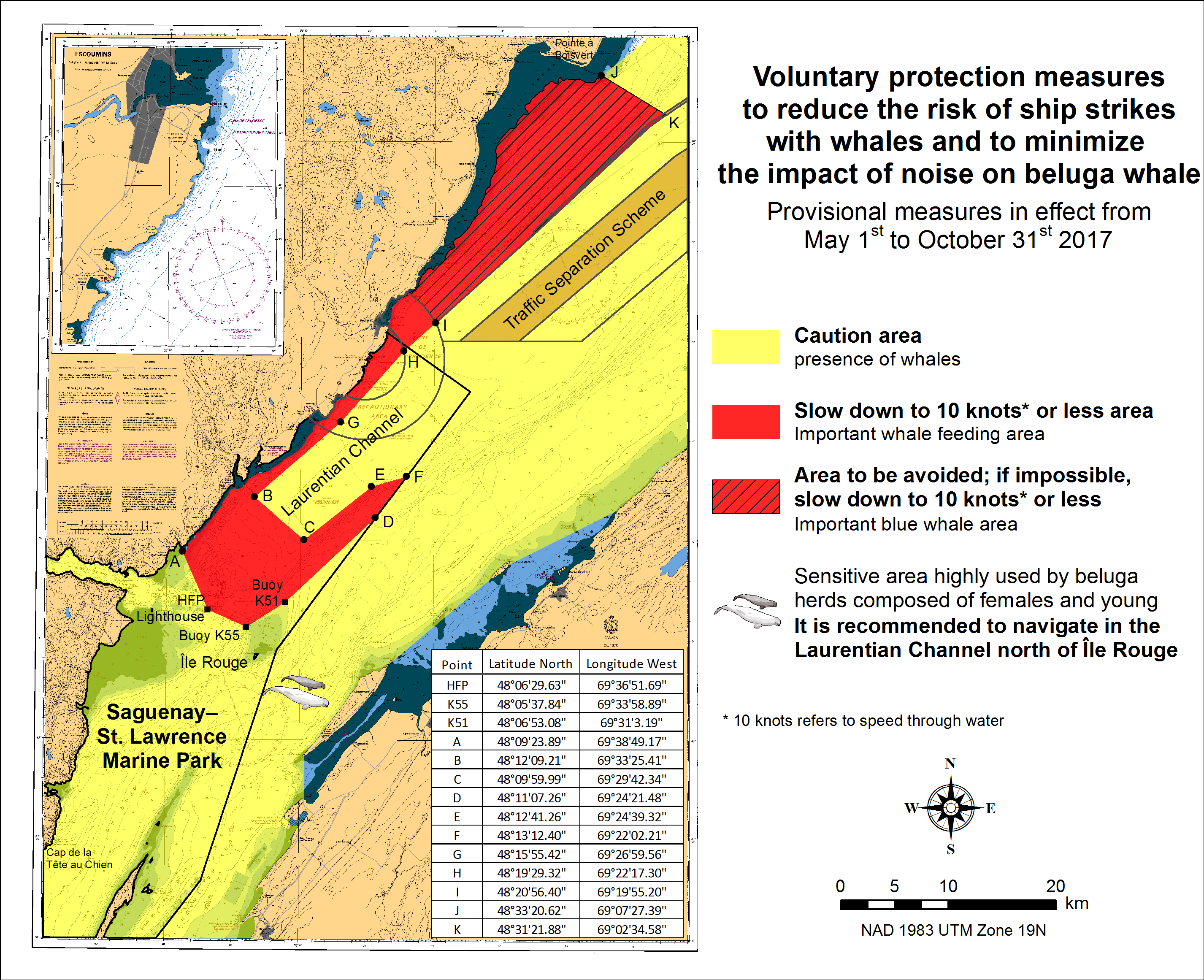
SAGUENAY-ST. LAWRENCE MARINE PARK AND SURROUNDING WATERS – WHALE PROTECTION
The waters in and around the Saguenay–St. Lawrence Marine Park are well known for the resident endangered beluga population and the wide diversity of whales that migrate there to feed, particularly between April and November.
Regulatory protection measures
All whale species that are found in the St. Lawrence are protected under the Marine Mammal Regulations, pursuant to the Fisheries Act. Within the boundaries of the Marine Park, specific measures are set out in the Marine Activities in the Saguenay–St. Lawrence Marine Park Regulations, pursuant to the Act Establishing the Saguenay–St. Lawrence Marine Park. Any collision with a marine mammal within the Marine Park must immediately be reported to a park warden at 1-866-508-9888. For collisions that occur outside the Marine Park or for any situation involving a marine mammal that is dead or in trouble, contact the emergency network at 1-877-722-5346 or on channel 16.
For more information on the Saguenay–St. Lawrence Marine Park, see section 5C of the Notices to Mariners Annual Edition 2017.
Voluntary protection measures
Provisional measures in effect from May 1st to October 31st, 2017. See map below.
These measures apply to merchant vessels and cruise ships between Pointe à Boisvert and Cap de la Tête au Chien to prevent collisions with whales. These measures should only be taken when they will not jeopardize navigational safety.
Caution area (yellow area): To reduce the risk of collisions with whales that can be present anywhere in this area, heightened vigilance of navigators is critical. Posting a lookout is recommended in order to increase the chances of seeing the whales and thus taking necessary measures to avoid them. If bypassing the whales is not possible, slow down and wait for the animals to move away to a distance greater than 400 meters (0.215 nautical miles) before resuming original speed. It is more difficult to see the animals at night therefore increased caution is recommended.
Slow down to 10 knots or less area (red area): To reduce the risk of collisions with whales in this feeding area, it is recommended that vessels slow down to a maximum speed through the water of 10 knots and post a lookout. It is further recommended to remain in the Laurentian Channel to the north of Île Rouge to minimize the impact of noise in a sensitive area south of this island, which is highly frequented by herds of beluga whales composed of females and young.
Area to be avoided (hatched red area): To reduce noise and the risk of collisions with whales, vessels should avoid transiting through this area which is highly frequented by blue whales, an endangered species. If the area cannot be avoided, slow down to a speed through the water of 10 knots or less.
CANADIAN HYDROGRAPHIC SERVICE – MODIFICATIONS TO THE 2017 CANADIAN TIDE AND CURRENT TABLES – VOLUME 3
Mariners should replace the following values for Baie-Trinité, Index no. 2815 published in the 2017 Canadian Tide and Current Tables with the attached table for Baie-Trinité on page 64, Volume 3, 2017 Canadian Tide and Current Tables, St. Lawrence River and Saguenay Fjord.
The Canadian Hydrographic Service of the Quebec Region has recently been informed that there is an error in the 2017 Canadian Tide and Current Tables, Volume 3, St. Lawrence River and Saguenay Fjord, page 64, Index no. 2815 – BAIE-TRINITÉ.
Mariners and users are advised that tidal prediction calculations for the secondary port of Baie-Trinité should be carried out on the reference port of SEPT-ÎLES rather than of Pointe-au-Père. The information and tidal differences for secondary port BAIE-TRINITÉ should be located in the block of stations on SEPT-ÎLES.
The tidal predictions of times and heights of the high and low tides on the website for Baie-Trinité are however correct.
Insert the new part of Table 3 provided in Section 1 of this monthly edition.
https://www.notmar.gc.ca/publications/monthly-mensuel/images/ed052017-part1-tidal-information.pdf
CANADIAN HYDROGRAPHIC SERVICE – MODIFICATION TO CATALOGUE 2: PACIFIC COAST/CÔTE PACIFIQUE
The Canadian Hydrographic Service has been recently informed that there is an error in the following chart catalogue:
Catalogue 2: Pacific Coast/Côte pacifique
Affix patch to Catalogue 2: Pacific Coast/Côte pacifique provided in Section 1 of this monthly edition.
https://www.notmar.gc.ca/publications/monthly-mensuel/images/ed072017-part1-catalogue2-patch.pdf
ERRATUM : GOLFE DU SAINT-LAURENT / GULF OF ST. LAWRENCE – RESTRICTED SPEED AREA FOR THE SAFETY OF NORTH ATLANTIC RIGHT WHALES
AMEND
Reference Chart: 4002
Due to an increased presence of endangered North Atlantic right whales in the Gulf of St. Lawrence, mariners are requested to proceed with caution in all areas of the Gulf of St. Lawrence between the following coordinates:
47º 10’ N 062º 00’ W; 47º 10’ N 065º 00’ W; 50º 20’ N 065º 00’ W; 50º 20’ N 062º 00’ W.
Within this area, all vessels 65 feet (19.8 m) or longer are requested to reduce speed (a speed of 10 knots is suggested, but not obligatory) until September 30, 2017. Report all observations of dead or injured marine mammals by calling 1-866-567-6277 (Marine Animal Response Society) or 1-877-772-5346 (Réseau québécois d’urgences pour les mammifères marins). The reporting of live whale sightings using Whale Alert is encouraged (http://www.whalealert.org/).
TO READ
GOLFE DU SAINT-LAURENT / GULF OF ST. LAWRENCE – SPEED RESTRICTION DUE TO INCREASED PRESENCE OF NORTH ATLANTIC RIGHT WHALESReference Chart: 4002
In order to promote navigation safety and protection of the marine environment due to an increased presence of North Atlantic right whales in the Gulf of St. Lawrence, all vessels of 65 feet (19.8m) or longer are instructed to proceed at a speed not exceeding 10.0 knots over the ground in the St. Lawrence River and the Gulf of St. Lawrence between the following coordinates: 47º 10’ N 062º 00’ W; 47º 10’ N 065º 00’ W; 50º 20’ N 065º 00’ W; 50º 20’ N 062º 00’ W.
Failure to comply with this speed restriction could lead to enforcement action under section 7 of the Collision Regulations.
Report all observations of live, dead or injured whales to the Canadian Coast Guard on VHF ch 16 or by calling the Marine Animal Response Society at 1-866-567-6277 or the Réseau québécois d’urgences pour les mammifères marins at 1-877-722-5346. The reporting of live whale sightings using Whale Alert is encouraged as well (http://www.whalealert.org/)
(NOTSHIP M1717/17, Q1189/17)
*801 CANADIAN HYDROGRAPHIC SERVICE – NAUTICAL CHARTS
|
CHARTS |
MAIN TITLE |
SCALE |
PUBLISHED |
CAT# |
PRICE |
|---|---|---|---|---|---|
|
New Editions |
|||||
|
1220 |
Baie des Sept-Îles |
1:25 000 |
24-MAR-2017 |
1 |
20.00 |
|
3598 |
Cape Scott to Cape Calvert |
1:74 490 |
11-NOV-2016 |
2 |
20.00 |
|
3909 |
Plans Chatham Sound |
1:15 000 |
28-APR-2017 |
2 |
20.00 |
|
3956 |
Malacca Passage to/à Bell Passage |
1:40 000 |
13-JAN-2017 |
2 |
20.00 |
|
3957 |
Approaches to/Approches à Prince Rupert Harbour |
1:40 000 |
07-OCT-2016 |
2 |
20.00 |
*802 CANADIAN HYDROGRAPHIC SERVICE – ELECTRONIC NAVIGATIONAL CHARTS
|
S-57 ENC NUMBER |
CHART TITLE |
|---|---|
|
NEW PRODUCTS |
|
|
CA373462 |
Storis Passage to/à Requisite Channel |
|
CA373463 |
Simpson Strait to/à Storis Passage |
|
CA473476 |
Inukjuak et les Approches and Approaches |
*803 CANADIAN COAST GUARD PUBLICATION – THE SUMMARY OF TEMPORARY AND PRELIMINARY NOTICES IS NOW PUBLISHED ON A MONTHLY BASIS ON THE NOTICES TO MARINERS WEBSITE
The Summary of Temporary and Preliminary Notices is now published on a monthly basis on the Notices to Mariners website. This will allow mariners to remain up-to-date each month on which Temporary and Preliminary notices are in effect, and also reference the complete notices for the details.
*804 CANADIAN COAST GUARD PUBLICATION – AMENDMENTS TO NOTICES TO MARINERS ANNUAL EDITION - SECTION A, NOTICE 5A: GENERAL REGULATORY REQUIREMENTS FOR ALL OCEANS ACT MARINE PROTECTED AREAS
|
AMEND |
TO READ |
|
|---|---|---|
|
Page 6 |
1.3 Eastport Marine Protected Areas |
1.4 Eastport Marine Protected Areas |
|
Page 9 |
1.4 Gilbert Bay Marine Protected Area |
1.5 Gilbert Bay Marine Protected Area |
|
Page 10 |
1.5 Basin Head Marine Protected Area |
1.6 Basin Head Marine Protected Area |
ADD (Starting from Page 6)
1.3 The St. Anns Bank Marine Protected Area
The St. Anns Bank Marine Protected Area was designated pursuant to the Oceans Act on June 2, 2017. The full text of the regulations may be accessed in the Canada Gazette Part II, Vol. 151, No. 12, 1199-1205 (http://canadagazette.gc.ca).
Coordinates
The St. Anns Bank Marine Protected Areais bounded by a series of rhumb lines drawn from points 1 to 10, and then back to point 1. All geographical coordinates (latitude and longitude) are expressed in the North America Datum 1983 (NAD83) reference system.
|
Point |
Latitude (North) |
Longitude (West) |
|---|---|---|
|
1 |
46° 10' |
59° 39' |
|
2 |
46° 10' |
59° 20' |
|
3 |
46° 16' |
59° 20' |
|
4 |
46° 25' |
59° 00' |
|
5 |
46° 25' |
58° 40' |
|
6 |
46° 14' |
58° 22' |
|
7 |
46° 04' |
58° 32' |
|
8 |
46° 04' |
58° 40' |
|
9 |
45° 56' |
58° 40' |
|
10 |
45° 47' |
59° 39' |
The St. Anns Bank Marine Protected Areais shown in the map below:
Regulatory Requirements for Vessels Operating in the St. Anns Bank Marine Protected Area
•See Section 5A - General Regulatory Requirements for all Oceans Act Marine Protected Areas.
•Specific requirements for the St. Anns Bank Marine Protected Area
oVessels must avoid discharge of ballast water in the Marine Protected Area. However, under certain circumstances, vessels when navigating on transoceanic voyages mayconduct ballast exchanges in the portion of the Marine Protected Area that overlaps with the Laurentian Channel, where the water depth is at least 300 m, and only between the dates December 1 and May 1. Please see the Ballast Water Control and Management Regulations for additional guidance (including exceptions) on ballast water management in and around the Marine Protected Area.
Guidelines for Vessels Operating in the Area (Year Round)
The following procedures are recommended in order to safeguard the Marine Protected Area and its resources.
1.Vessels must comply with all relevant provisions of the Marine Mammal Regulations pursuant to the Fisheries Act. Further guidance is found in Section 5 - General Guidelines for Aquatic Species at Risk and Important Marine Mammal Areas.
2.Report any marine mammal collisions, entanglements, distressed or dead animals to the Marine Animal Response Society’s emergency hotline (1-866-567-6277), or via VHF channel 16. Sightings of healthy marine mammals should be reported to XMARwhalesightings@dfo-mpo.gc.ca. The following information about the sighting should be included: date, time, location, and species. Photos and videos should be submitted if available.
3.Report all live and dead sea turtle sightings and incidents (e.g. entanglements, collisions) to the Canadian Sea Turtle Network’s hotline (1-888-729-4667) or online at http://seaturtle.ca/turtle-sighting/. The following information about the sighting or incident should be included: date, time, location, species, and condition of the animal. Photos and videos should be submitted if available.
*805 CANADIAN COAST GUARD PUBLICATION – AMENDMENTS TO NOTICES TO MARINERS ANNUAL EDITION - SECTION F, NOTICE 35: FIRING PRACTICE AND EXERCISE AREAS
Page 4:
AMEND
|
Nova Scotia Area |
|||||
|---|---|---|---|---|---|
|
Sea Areas |
Air Space |
Location |
Coordinates |
Employment |
Diagram |
|
ECHO TWO |
To 20,000 feet |
Charts 4001, 4003 4012, 4013, 4320 and 8007 |
44°19′N63°30′W 44°19′N63°00′W 44°00′N63°00′W 44°00′N63°30′W |
Sub surface operations area. Firing Exercise (FIREX) |
1 |
TO READ
|
Nova Scotia Area |
|||||
|---|---|---|---|---|---|
|
Sea Areas |
Air Space |
Location |
Coordinates |
Employment |
Diagram |
|
ECHO TWO |
To 20,000 feet |
Charts 4001, 4003 4012, 4013, 4320 and 8007 |
44°19′N063°30′W 44°19′N063°00′W 44°10′N063°00′W 44°10′N063°30′W |
Sub surface operations area. Firing Exercise (FIREX) |
1 |
ADD
|
Nova Scotia Area |
|||||
|---|---|---|---|---|---|
|
Sea Areas |
Air Space |
Location |
Coordinates |
Employment |
Diagram |
|
ECHO ONE |
… |
… |
… |
… |
… |
|
HOTBOX ONE |
To 5,000 feet |
Charts 4013 |
44°00’N 063°00’W 44°19’N 063°00’W 44°19’N 062°30’W 44°00’N 062°30’W |
Sub surface operations area. Firing Exercise (FIREX) |
1 |
|
ECHO TWO |
… |
… |
… |
… |
… |
|
ECHO THREE |
To 20,000 feet |
Charts 4001, 4003 4012, 4013, 4320 and 8007 |
44°10’N 063°30’W 44°10’N 063°00’W 44°00’N 063°00’W 44°00’N 063°30’W |
Sub surface operations area. Firing Exercise (FIREX) |
1 |
|
FOXTROT ONE |
… |
… |
… |
… |
… |
Page 8:
ADD
|
Nova Scotia Area |
|||||
|---|---|---|---|---|---|
|
Sea Areas |
Air Space |
Location |
Coordinates |
Employment |
Diagram |
|
MIKE ONE |
… |
… |
… |
… |
… |
|
HOTBOX TWO |
To 5,000 feet |
Chart 4001,4003 8006 |
42°50’N 064°00’W 43°00’N 064°00’W 43°00’N 063°30’W 42°50’N 063°30’W |
Sub surface operations area. Firing Exercise (FIREX) |
1 |
|
MIKE TWO |
… |
… |
… |
… |
… |
Page 9 (after the table):
REPLACE
*806 WEST POINT À / TO BAIE DE TRACADIE – UNLIT SPAR BUOY REPLACED BY LIT SPAR BUOY
Reference Chart: 4906
Tabusintac buoy TA47 (LL 6240.22) (47° 20’ 27.1”N 064° 57’ 27.0”W) has been replaced by
Tabusintac Gully light buoy TA47 (LL 1240.22) (47° 20’ 27.1”N 064° 57’ 27.0”W).
(G2017-062, 063)
*807 CARAQUET HARBOUR, BAIE DE SHIPPEGAN AND / ET MISCOU HARBOUR – UNLIT BUOY REPLACED BY LIT BUOY
Reference Chart: 4913
Fox Dens Gully buoy TK12 (LL 6262.18) (47° 53’ 07.2”N 064° 30’ 20.4”W) has been replaced by
Fox Dens Gully light buoy TK12 (LL 1262.18) (47° 53’ 06.7”N 064° 30’ 27.4”W).
(G2017-057, 058)
*808(P) DETROIT RIVER, LAKE ST. CLAIR AND ST. CLAIR RIVER – LIGHT TO BE DISCONTINUED
Reference Chart: 14853 (U.S.)
The Canadian Coast Guard intends to permanently discontinue the following aid to navigation:
The light Courtright (LL 753) (42° 48’ 23.1”N 082° 28’ 42.5”W)
Comments on this action are solicited from mariners and other interested parties. Comments should be directed to the following within three months from the date of this notice:
Supervisor, Gary Greer
Aids to Navigation and Waterways
Canadian Coast Guard
28 Waubeek St.
Parry Sound, ON, P2A 1B9
Email: gary.greer@dfo-mpo.gc.ca
Any objections raised must state the facts on which they are based and should include supporting information on safety, commerce and public benefit.
(B2017-013)
*809 GRINDSTONE POINT TO/À BERENS RIVER – LIGHT REMAINS IN SERVICE
Reference: Notice 1114(P)/14 is cancelled (Chart 6267).
(A2017-049)
*810 TAYLORS HEAD TO / À SHUT-IN ISLAND – AIDS TO NAVIGATION CHANGED
Reference: Notice 609(P)/15is cancelled.
Reference Chart: 4236
The following aids to navigation remain unchanged:
Musquodoboit Harbour Spar YV20 (LL 5566.115) (44° 42’ 34.0”N 063° 04’ 50.0”W)
Musquodoboit (NE Francis Nose Is) Spar YV22 (LL 5566.13) (44° 42’ 58.0”N 063° 05’ 03.1”W)
(F2016-022, 023, 024, 025, 026, 027, 028, 029, 031, F2017-021)
SECTION 2 - CHART CORRECTIONS
4001 - Gulf of Maine to Strait of Belle Isle / au Detroit de Belle Isle - New Edition - 01-DEC-1995 - NAD 1983
| 11-AUG-2017 | LNM/D. 28-JUL-2017 | ||
| Add |
environmentally sensitive sea area with legend, St Anns
Bank MPA / ZPM du banc de Sainte-Anne (See Chart No. 1, N22) This notice affects Electronic Navigational Chart: CA179245, CA276090, CA276204, CA276271, CA276284, CA376303 |
joining 46°10′00.0″N 059°39′00.0″W 45°47′00.0″N 059°39′00.0″W 45°56′00.0″N 058°40′00.0″W 46°04′00.0″N 058°40′00.0″W 46°04′00.0″N 058°32′00.0″W 46°14′00.0″N 058°22′00.0″W 46°25′00.0″N 058°40′00.0″W 46°25′00.0″N 059°00′00.0″W 46°16′00.0″N 059°20′00.0″W 46°10′00.0″N 059°20′00.0″W and 46°10′00.0″N 059°39′00.0″W |
|
| DFO(6308006-01) |
4002 - Golfe du Saint-Laurent / Gulf of St. Lawrence - New Edition - 30-OCT-2015 - NAD 1983
| 11-AUG-2017 | LNM/D. 28-JUL-2017 | ||
| Add |
environmentally sensitive sea area with legend, St Anns
Bank MPA / ZPM du banc de Sainte-Anne (See Chart No. 1, N22) This notice affects Electronic Navigational Chart: CA179245, CA276090, CA276204, CA276271, CA276284, CA376303 |
joining 46°10′00.0″N 059°39′00.0″W 45°47′00.0″N 059°39′00.0″W 45°56′00.0″N 058°40′00.0″W 46°04′00.0″N 058°40′00.0″W 46°04′00.0″N 058°32′00.0″W 46°14′00.0″N 058°22′00.0″W 46°25′00.0″N 058°40′00.0″W 46°25′00.0″N 059°00′00.0″W 46°16′00.0″N 059°20′00.0″W 46°10′00.0″N 059°20′00.0″W and 46°10′00.0″N 059°39′00.0″W |
|
| DFO(6308006-01) |
4003 - Cape Breton to / à Cape Cod - New Edition - 21-MAR-2003 - NAD 1983
| 11-AUG-2017 | LNM/D. 28-JUL-2017 | ||
| Add |
environmentally sensitive sea area with legend, St Anns
Bank Marine Protected Area / Zone de protection marine du
banc de Sainte-Anne (See Chart No. 1, N22) This notice affects Electronic Navigational Chart: CA179245, CA276090, CA276204, CA276271, CA276284, CA376303 |
joining 46°10′00.0″N 059°39′00.0″W 45°47′00.0″N 059°39′00.0″W 45°56′00.0″N 058°40′00.0″W 46°04′00.0″N 058°40′00.0″W 46°04′00.0″N 058°32′00.0″W 46°14′00.0″N 058°22′00.0″W 46°25′00.0″N 058°40′00.0″W 46°25′00.0″N 059°00′00.0″W 46°16′00.0″N 059°20′00.0″W 46°10′00.0″N 059°20′00.0″W and 46°10′00.0″N 059°39′00.0″W |
|
| DFO(6308006-01) |
4006 - Newfoundland and Labrador/Terre-Neuve-et-Labrador to Bermuda / aux Bermudes - New Edition - 08-AUG-2003 - NAD 1983
| 11-AUG-2017 | LNM/D. 02-DEC-2016 | ||
| Add |
environmentally sensitive sea area with legend, St Anns
Bank MPA / ZPM du banc de Sainte-Anne (See Chart No. 1, N22) This notice affects Electronic Navigational Chart: CA179245, CA276090, CA276204, CA276271, CA276284, CA376303 |
joining 46°10′00.0″N 059°39′00.0″W 45°47′00.0″N 059°39′00.0″W 45°56′00.0″N 058°40′00.0″W 46°04′00.0″N 058°40′00.0″W 46°04′00.0″N 058°32′00.0″W 46°14′00.0″N 058°22′00.0″W 46°25′00.0″N 058°40′00.0″W 46°25′00.0″N 059°00′00.0″W 46°16′00.0″N 059°20′00.0″W 46°10′00.0″N 059°20′00.0″W and 46°10′00.0″N 059°39′00.0″W |
|
| DFO(6308006-01) |
4013 - Halifax to / à Sydney - New Edition - 06-SEP-2002 - NAD 1983
| 11-AUG-2017 | LNM/D. 07-JUL-2017 | ||
| Add |
environmentally sensitive sea area with legend, St Anns
Bank Marine Protected Area / Zone de protection marine du
banc de Sainte-Anne (See Chart No. 1, N22) This notice affects Electronic Navigational Chart: CA179245, CA276090, CA276204, CA276271, CA276284, CA376303 |
joining 45°53′00.0″N 059°00′00.0″W 45°47′00.0″N 059°39′00.0″W 46°10′00.0″N 059°39′00.0″W 46°10′00.0″N 059°20′00.0″W 46°16′00.0″N 059°20′00.0″W and 46°22′00.0″N 059°06′40.0″W |
|
| DFO(6308006-01) | |||
| Replace |
depth of 0 fathoms, 4 feet with depth of 0 fathoms, 3
feet (See Chart No. 1, I10) This notice affects Electronic Navigational Chart: CA276286, CA376691 |
45°41′09.6″N 062°36′52.3″W | |
| DFO(6308023-02) |
4015 - Sydney to / à Saint-Pierre - New Edition - 28-MAR-2003 - NAD 1983
| 11-AUG-2017 | LNM/D. 07-JUL-2017 | ||
| Add |
environmentally sensitive sea area with legend, St Anns
Bank Marine Protected Area / Zone de protection marine du
banc de Sainte-Anne (See Chart No. 1, N22) This notice affects Electronic Navigational Chart: CA179245, CA276090, CA276204, CA276271, CA276284, CA376303 |
joining 46°10′00.0″N 059°39′00.0″W 45°47′00.0″N 059°39′00.0″W 45°56′00.0″N 058°40′00.0″W 46°04′00.0″N 058°40′00.0″W 46°04′00.0″N 058°32′00.0″W 46°14′00.0″N 058°22′00.0″W 46°25′00.0″N 058°40′00.0″W 46°25′00.0″N 059°00′00.0″W 46°16′00.0″N 059°20′00.0″W 46°10′00.0″N 059°20′00.0″W and 46°10′00.0″N 059°39′00.0″W |
|
| DFO(6308006-01) |
4022 - Cabot Strait and approaches / Détroit de Cabot et les approches - New Edition - 17-JAN-2003 - NAD 1983
| 11-AUG-2017 | LNM/D. 28-JUL-2017 | ||
| Add |
environmentally sensitive sea area with legend, St Anns
Bank Marine Protected Area / Zone de protection marine du
banc de Sainte-Anne (See Chart No. 1, N22) This notice affects Electronic Navigational Chart: CA179245, CA276090, CA276204, CA276271, CA276284, CA376303 |
joining 46°00′03.0″N 059°39′00.0″W 46°04′00.0″N 058°40′00.0″W 46°04′00.0″N 058°32′00.0″W 46°14′00.0″N 058°22′27.0″W 46°25′00.0″N 058°40′00.0″W 46°25′00.0″N 059°00′00.0″W 46°16′00.0″N 059°20′00.0″W 46°10′00.0″N 059°20′00.0″W 46°10′00.0″N 059°39′00.0″W and 46°00′03.0″N 059°39′00.0″W |
|
| DFO(6308006-01) |
4023 - Northumberland Strait / Détroit de Northumberland - New Edition - 27-DEC-2002 - NAD 1983
| 11-AUG-2017 | LNM/D. 28-JUL-2017 | ||
| Replace |
depth of 0 fathoms, 4 feet with depth of 0 fathoms, 3
feet (See Chart No. 1, I10) This notice affects Electronic Navigational Chart: CA276286, CA376691 |
45°41′09.6″N 062°36′52.3″W | |
| DFO(6308023-02) |
4024 - Baie des Chaleurs/Chaleur Bay aux/to Îles de la Madeleine - New Edition - 06-MAR-2015 - NAD 1983
| 04-AUG-2017 | LNM/D. 21-JUL-2017 | ||
| Replace |
red starboard lighted pillar buoy Fl R with bell, marked
TJ2 with red-white fairway lighted pillar buoy Mo(A) with
bell, marked TJ (See Chart No. 1, Qf, Qh) This notice affects Electronic Navigational Chart: CA279075, CA376187, CA476275 |
47°42′04.0″N 064°39′05.0″W | |
| (G2017008) LL(1248) DFO(6307891-01) |
4045 - Sable Island Bank / Banc de I'Île de Sable to / au St. Pierre Bank / Banc de Saint-Pierre - New Edition - 10-OCT-2003 - NAD 1983
| 11-AUG-2017 | LNM/D. 07-JUL-2017 | ||
| Add |
environmentally sensitive sea area with legend, St Anns
Bank Marine Protected Area / Zone de protection marine du
banc de Sainte-Anne (See Chart No. 1, N22) This notice affects Electronic Navigational Chart: CA179245, CA276090, CA276204, CA276271, CA276284, CA376303 |
joining 46°10′00.0″N 059°39′00.0″W 45°47′00.0″N 059°39′00.0″W 45°56′00.0″N 058°40′00.0″W 46°04′00.0″N 058°40′00.0″W 46°04′00.0″N 058°32′00.0″W 46°14′00.0″N 058°22′00.0″W 46°25′00.0″N 058°40′00.0″W 46°25′00.0″N 059°00′00.0″W 46°16′00.0″N 059°20′00.0″W 46°10′00.0″N 059°20′00.0″W and 46°10′00.0″N 059°39′00.0″W |
|
| DFO(6308006-01) |
4202 - Halifax Harbour: Point Pleasant to / à Bedford Basin - New Edition - 26-FEB-2016 - NAD 1983
| 25-AUG-2017 | LNM/D. 28-JUL-2017 | ||
| Add |
footbridge with legend ′Flo′ (See Chart No. 1, D20.2) This notice affects Electronic Navigational Chart: CA576003 |
between 44°38′52.7″N 063°34′10.4″W and 44°38′57.8″N 063°34′12.9″W |
|
| DFO(6308030-01) |
4227 - Country Harbour to / au Ship Harbour - New Chart - 24-MAY-1991 - NAD 1983
| 11-AUG-2017 | LNM/D. 03-MAR-2017 | ||
| Replace |
depth of 7 metres with depth of 5 metres, 8
decimetres (See Chart No. 1, I10) This notice affects Electronic Navigational Chart: CA376083 |
44°47′41.7″N 062°34′47.2″W | |
| DFO(6308020-06) |
4235 - Barren Island to / à Taylors Head - New Edition - 28-APR-2000 - NAD 1983
| 11-AUG-2017 | LNM/D. 12-FEB-2016 | ||
| Add |
depth of 2 metres, 4 decimetres (See Chart No. 1, I10) This notice affects Electronic Navigational Chart: CA376102 |
44°49′34.6″N 062°31′03.8″W | |
| DFO(6308020-09) | |||
| Add |
depth of 4 metres (See Chart No. 1, I10) This notice affects Electronic Navigational Chart: CA376102 |
44°49′09.2″N 062°27′29.3″W | |
| DFO(6308020-10) | |||
| Replace |
depth of 2 metres, 1 decimetre with depth of 1 metre, 4
decimetres (See Chart No. 1, I10) This notice affects Electronic Navigational Chart: CA376102 |
44°49′12.8″N 062°20′40.4″W | |
| DFO(6308020-11) |
4236 - Taylors Head to / à Shut-in Island - New Edition - 13-JUL-2001 - NAD 1983
| 11-AUG-2017 | LNM/D. 28-JUL-2017 | ||
| Add |
depth of 4 metres, 1 decimetre (See Chart No. 1, I10) This notice affects Electronic Navigational Chart: CA376083 |
44°46′41.2″N 062°40′21.1″W | |
| DFO(6308020-01) | |||
| Delete |
depth of 2 metres, 7 decimetres (See Chart No. 1, I10) This notice affects Electronic Navigational Chart: CA376083 |
44°48′13.0″N 062°38′50.2″W | |
| DFO(6308020-02) | |||
| Add |
depth of 1 metre, 5 decimetres (See Chart No. 1, I10) This notice affects Electronic Navigational Chart: CA376083 |
44°48′10.4″N 062°38′55.0″W | |
| DFO(6308020-03) | |||
| Delete |
depth of 1 metre, 5 decimetres (See Chart No. 1, I10) This notice affects Electronic Navigational Chart: CA376083 |
44°48′41.2″N 062°37′22.2″W | |
| DFO(6308020-04) | |||
| Add |
depth of 0 metres, 7 decimetres (See Chart No. 1, I10) This notice affects Electronic Navigational Chart: CA376083 |
44°48′41.3″N 062°37′17.0″W | |
| DFO(6308020-05) | |||
| Replace |
depth of 7 metres with depth of 5 metres, 8
decimetres (See Chart No. 1, I10) This notice affects Electronic Navigational Chart: CA376083 |
44°47′41.7″N 062°34′47.2″W | |
| DFO(6308020-06) | |||
| Replace |
depth of 4 metres, 6 decimetres with depth of 3 metres, 4
decimetres (See Chart No. 1, I10) This notice affects Electronic Navigational Chart: CA376083 |
44°46′33.4″N 062°35′42.8″W | |
| DFO(6308020-07) | |||
| Add |
depth of 3 metres (See Chart No. 1, I10) This notice affects Electronic Navigational Chart: CA376083 |
44°46′37.4″N 062°36′18.0″W | |
| DFO(6308020-08) | |||
| Add |
depth of 2 metres, 4 decimetres (See Chart No. 1, I10) This notice affects Electronic Navigational Chart: CA376102 |
44°49′34.6″N 062°31′03.8″W | |
| DFO(6308020-09) | |||
| Replace |
depth of 2 metres, 2 decimetres with depth of 1 metre, 4
decimetres (See Chart No. 1, I10) This notice affects Electronic Navigational Chart: CA376083 |
44°42′03.8″N 062°50′49.7″W | |
| DFO(6308024-01) |
4240 - Liverpool Harbour to / à Lockeport Harbour - New Chart - 06-OCT-1989 - NAD 1983
| 11-AUG-2017 | LNM/D. 09-JUN-2017 | ||
| Add |
depth of 1 metre, 6 decimetres (See Chart No. 1, I10) This notice affects Electronic Navigational Chart: CA376045 |
43°48′16.5″N 064°55′30.6″W | |
| DFO(6308022-01) | |||
| Add |
depth of 0 metres, 5 decimetres (See Chart No. 1, I10) This notice affects Electronic Navigational Chart: CA376045 |
43°49′19.7″N 064°53′03.2″W | |
| DFO(6308022-02) |
4241 - Lockeport to / à Cape Sable - New Edition - 08-NOV-2002 - NAD 1983
| 18-AUG-2017 | LNM/D. 09-JUN-2017 | ||
| Replace |
depth of 2 metres, 4 decimetres with depth of 1 metre, 2
decimetres (See Chart No. 1, I10) This notice affects Electronic Navigational Chart: CA376047 |
43°34′15.4″N 065°26′10.2″W | |
| DFO(6308021-01) | |||
| Replace |
depth of 1 metre, 8 decimetres with depth of 1 metre, 1
decimetre (See Chart No. 1, I10) This notice affects Electronic Navigational Chart: CA376047 |
43°34′32.6″N 065°25′42.8″W | |
| DFO(6308021-02) | |||
| Delete |
depth of 2 metres, 4 decimetres (See Chart No. 1, I10) This notice affects Electronic Navigational Chart: CA376047 |
43°34′28.9″N 065°25′32.9″W | |
| DFO(6308021-03) | |||
| Add |
depth of 1 metre, 2 decimetres (See Chart No. 1, I10) This notice affects Electronic Navigational Chart: CA376047 |
43°34′25.4″N 065°25′30.9″W | |
| DFO(6308021-04) |
4307 - Canso Harbour to / au Strait of Canso - New Edition - 04-JAN-2008 - NAD 1983
| 11-AUG-2017 | LNM/D. 28-JUL-2017 | ||
| Replace |
depth of 2 fathoms, 2 feet with depth of 1 fathom, 1
foot (See Chart No. 1, I10) This notice affects Electronic Navigational Chart: CA476277, CA576222 |
45°30′28.5″N 060°57′27.9″W | |
| DFO(6308019-02) | |||
| Replace |
depth of 2 fathoms, 1 foot with depth of 1 fathom, 5
feet (See Chart No. 1, I10) This notice affects Electronic Navigational Chart: CA476277 |
45°30′49.3″N 060°57′12.8″W | |
| DFO(6308019-03) | |||
| Replace |
depth of 1 fathom, 3 feet with depth of 0 fathoms, 2
feet (See Chart No. 1, I10) This notice affects Electronic Navigational Chart: CA476277 |
45°30′54.9″N 060°57′02.0″W | |
| DFO(6308019-04) | |||
| Replace |
depth of 0 fathoms, 2 feet with depth awash 0
fathoms (See Chart No. 1, I10, Kb) This notice affects Electronic Navigational Chart: CA476277 |
45°30′55.4″N 060°56′55.6″W | |
| DFO(6308019-06) |
4308 - Petit-de-Grat Inlet - New Edition - 21-MAR-2003 - NAD 1983
| 11-AUG-2017 | LNM/D. 28-JUL-2017 | ||
| Replace |
depth of 3 metres, 7 decimetres with depth of 2 metres, 6
decimetres (See Chart No. 1, I10) This notice affects Electronic Navigational Chart: CA576222 |
45°30′23.7″N 060°57′36.3″W | |
| DFO(6308019-01) | |||
| Replace |
depth of 4 metres, 3 decimetres with depth of 2 metres, 1
decimetre (See Chart No. 1, I10) This notice affects Electronic Navigational Chart: CA476277, CA576222 |
45°30′28.5″N 060°57′27.9″W | |
| DFO(6308019-02) | |||
| Add |
depth of 0 metres, 7 decimetres (See Chart No. 1, I10) This notice affects Electronic Navigational Chart: CA576222 |
45°30′26.7″N 060°57′30.7″W | |
| DFO(6308019-05) |
4308 - St. Peters Bay to / à Strait of Canso - New Edition - 21-MAR-2003 - NAD 1983
| 11-AUG-2017 | LNM/D. 28-JUL-2017 | ||
| Replace |
depth of 4 metres, 3 decimetres with depth of 2 metres, 1
decimetre (See Chart No. 1, I10) This notice affects Electronic Navigational Chart: CA476277, CA576222 |
45°30′28.5″N 060°57′27.9″W | |
| DFO(6308019-02) | |||
| Replace |
depth of 4 metres with depth of 3 metres, 5
decimetres (See Chart No. 1, I10) This notice affects Electronic Navigational Chart: CA476277 |
45°30′49.3″N 060°57′12.8″W | |
| DFO(6308019-03) | |||
| Replace |
depth of 2 metres, 7 decimetres with depth of 0 metres, 6
decimetres (See Chart No. 1, I10) This notice affects Electronic Navigational Chart: CA476277 |
45°30′54.9″N 060°57′02.0″W | |
| DFO(6308019-04) | |||
| Replace |
depth of 0 metres, 6 decimetres with depth awash 0
metres (See Chart No. 1, I10, Kb) This notice affects Electronic Navigational Chart: CA476277 |
45°30′55.4″N 060°56′55.6″W | |
| DFO(6308019-06) |
4335 - Strait of Canso and Approaches / et les approches - New Edition - 04-JAN-2008 - NAD 1983
| 11-AUG-2017 | LNM/D. 30-JUN-2017 | ||
| Replace |
depth of 2 fathoms, 1 foot with depth of 1 fathom, 5
feet (See Chart No. 1, I10) This notice affects Electronic Navigational Chart: CA476277 |
45°30′49.3″N 060°57′12.8″W | |
| DFO(6308019-03) |
4375 - Guyon Island to / à Flint Island - New Edition - 11-OCT-2002 - NAD 1983
| 11-AUG-2017 | LNM/D. 31-MAR-2017 | ||
| Add |
environmentally sensitive sea area with legend, St Anns
Bank Marine Protected Area / Zone de protection marine du
banc de Sainte-Anne (See Chart No. 1, N22) This notice affects Electronic Navigational Chart: CA179245, CA276090, CA276204, CA276271, CA276284, CA376303 |
joining 45°50′43.0″N 059°14′37.0″W 45°47′00.0″N 059°39′00.0″W 46°10′00.0″N 059°39′00.0″W 46°10′00.0″N 059°20′00.0″W and 46°11′23.5″N 059°20′00.0″W |
|
| DFO(6308006-01) |
4384 - Pearl Island to / à Cape La Have - New Edition - 10-JAN-2003 - NAD 1983
| 25-AUG-2017 | LNM/D. 05-AUG-2016 | ||
| Replace |
depth of 4 metres, 3 decimetres with depth of 2 metres, 1
decimetre (See Chart No. 1, I10) This notice affects Electronic Navigational Chart: CA476664 |
44°14′47.4″N 064°21′55.2″W | |
| DFO(6308029-01) | |||
| Delete |
depth of 2 metres, 7 decimetres (See Chart No. 1, I10) This notice affects Electronic Navigational Chart: CA476664 |
44°14′31.9″N 064°22′09.0″W | |
| DFO(6308029-05) | |||
| Delete |
depth of 3 metres (See Chart No. 1, I10) This notice affects Electronic Navigational Chart: CA476664 |
44°14′31.7″N 064°22′14.4″W | |
| DFO(6308029-06) | |||
| Add |
depth of 1 metre, 8 decimetres (See Chart No. 1, I10) This notice affects Electronic Navigational Chart: CA476664 |
44°14′31.3″N 064°22′11.4″W | |
| DFO(6308029-07) |
4394 - LaHave River: West Ironbound Island to / à Riverport - New Edition - 26-JUL-2002 - NAD 1983
| 25-AUG-2017 | LNM/D. 05-AUG-2016 | ||
| Replace |
depth of 14 feet with depth of 7 feet (See Chart No. 1, I10) This notice affects Electronic Navigational Chart: CA476664 |
44°14′45.7″N 064°21′56.2″W | |
| DFO(6308029-01) | |||
| Delete |
depth of 23 feet (See Chart No. 1, I10) |
44°14′41.0″N 064°22′05.1″W | |
| DFO(6308029-02) | |||
| Add |
depth of 15 feet (See Chart No. 1, I10) |
44°14′40.5″N 064°22′06.3″W | |
| DFO(6308029-03) | |||
| Replace |
depth of 22 feet with depth of 6 feet (See Chart No. 1, I10) |
44°14′31.3″N 064°22′11.4″W | |
| DFO(6308029-04) | |||
| Replace |
depth of 17 feet with depth of 5 feet (See Chart No. 1, I10) |
44°14′28.9″N 064°22′10.3″W | |
| DFO(6308029-08) | |||
| Add |
depth of 1 foot (See Chart No. 1, I10) |
44°14′27.5″N 064°22′08.0″W | |
| DFO(6308029-09) | |||
| Delete |
depth of 33 feet (See Chart No. 1, I10) |
44°14′27.4″N 064°22′08.0″W | |
| DFO(6308029-10) |
4404 - Cape George to / à Pictou - New Edition - 28-FEB-2014 - NAD 1983
| 11-AUG-2017 | LNM/D. 03-FEB-2017 | ||
| Replace |
depth of 1 metre, 2 decimetres with depth of 0 metres, 9
decimetres (See Chart No. 1, I10) This notice affects Electronic Navigational Chart: CA276286, CA376691 |
45°41′09.6″N 062°36′52.3″W | |
| DFO(6308023-02) |
4437 - Pictou Harbour - New Edition - 14-MAR-2003 - NAD 1983
| 11-AUG-2017 | LNM/D. 24-MAR-2017 | ||
| Add |
depth of 3 feet (See Chart No. 1, I10) |
45°41′09.6″N 062°36′52.3″W | |
| DFO(6308023-01) | |||
| Add |
depth of 2 feet (See Chart No. 1, I10) |
45°41′09.1″N 062°37′00.2″W | |
| DFO(6308023-03) |
4467 - Rustico Bay - New Edition - 10-JAN-2003 - NAD 1983
| 11-AUG-2017 | LNM/D. 25-JUL-2014 | ||
| Replace |
depth of 11 feet with depth of 7 feet (See Chart No. 1, I10) |
46°27′27.9″N 063°17′09.7″W | |
| DFO(6308025-01) | |||
| Replace |
depth of 11 feet with depth of 4 feet (See Chart No. 1, I10) |
46°27′25.9″N 063°17′11.6″W | |
| DFO(6308025-02) | |||
| Add |
depth of 3 feet (See Chart No. 1, I10) |
46°27′23.6″N 063°17′15.0″W | |
| DFO(6308025-03) | |||
| Replace |
depth of 13 feet with depth of 7 feet (See Chart No. 1, I10) |
46°27′16.3″N 063°17′24.7″W | |
| DFO(6308025-04) | |||
| Add |
depth of 9 feet (See Chart No. 1, I10) |
46°27′18.6″N 063°17′38.3″W | |
| DFO(6308025-05) | |||
| Replace |
depth of 7 feet with depth of 2 feet (See Chart No. 1, I10) |
46°27′19.3″N 063°17′40.5″W | |
| DFO(6308025-06) | |||
| Replace |
depth of 9 feet with depth of 4 feet (See Chart No. 1, I10) |
46°27′19.8″N 063°17′44.4″W | |
| DFO(6308025-07) | |||
| Add |
depth of 9 feet (See Chart No. 1, I10) |
46°27′20.4″N 063°17′48.6″W | |
| DFO(6308025-08) | |||
| Delete |
depth of 13 feet (See Chart No. 1, I10) |
46°27′19.3″N 063°17′48.6″W | |
| DFO(6308025-09) | |||
| Add |
depth of 1 foot (See Chart No. 1, I10) |
46°27′19.7″N 063°17′54.8″W | |
| DFO(6308025-10) | |||
| Add |
depth of 5 feet (See Chart No. 1, I10) |
46°27′20.8″N 063°17′59.0″W | |
| DFO(6308025-11) | |||
| Add |
depth awash of 0 feet (See Chart No. 1, Kb) |
46°27′21.9″N 063°18′03.2″W | |
| DFO(6308025-12) | |||
| Delete |
depth of 8 feet (See Chart No. 1, I10) |
46°27′21.7″N 063°18′04.6″W | |
| DFO(6308025-13) | |||
| Add |
depth of 4 feet (See Chart No. 1, I10) |
46°27′21.5″N 063°18′06.0″W | |
| DFO(6308025-14) |
4485 - Cap des Rosiers à/to Chandler - New Edition - 17-JUN-2011 - NAD 1983
| 04-AUG-2017 | LNM/D. 07-JUL-2017 | ||
| Add |
depth of 11 metres, 3 decimetres (See Chart No. 1, I10) This notice affects Electronic Navigational Chart: CA379086 |
48°50′53.6″N 064°11′14.4″W | |
| DFO(6409690-01) |
4486 - Baie des Chaleurs / Chaleur Bay - New Edition - 19-FEB-1999 - NAD 1983
| 04-AUG-2017 | LNM/D. 19-MAY-2017 | ||
| Replace |
red starboard lighted pillar buoy Fl R with bell, marked
TJ2 with red-white fairway lighted pillar buoy Mo(A) with
bell, marked TJ (See Chart No. 1, Qf, Qh) This notice affects Electronic Navigational Chart: CA279075, CA376187, CA476275 |
47°42′04.0″N 064°39′05.0″W | |
| (G2017008) LL(1248) DFO(6307891-01) |
4530 - Hamilton Sound: Eastern Portion / Partie-est - New Edition - 15-MAR-2002 - NAD 1983
| 25-AUG-2017 | LNM/D. 26-JUN-2015 | ||
| Add |
ferry route (See Chart No. 1, M50) This notice affects Electronic Navigational Chart: CA376655, CA476813 |
joining 49°34′03.5″N 054°18′26.6″W 49°34′10.4″N 054°18′15.1″W and 49°34′14.5″N 054°18′08.1″W |
|
| DFO(6308011-06) |
4820 - Cape Freels to / à Exploits Islands - New Chart - 01-JUL-2005 - NAD 1983
| 25-AUG-2017 | LNM/D. 26-FEB-2016 | ||
| Delete |
ferry route (See Chart No. 1, M50) This notice affects Electronic Navigational Chart: CA376655, CA476813 |
joining 49°33′24.1″N 054°28′31.7″W 49°34′07.8″N 054°24′09.1″W and 49°34′14.1″N 054°24′09.1″W |
|
| DFO(6308011-03) | |||
| Add |
ferry route (See Chart No. 1, M50) This notice affects Electronic Navigational Chart: CA376655, CA476813 |
between 49°33′30.1″N 054°26′04.2″W and 49°34′08.2″N 054°23′40.4″W |
|
| DFO(6308011-04) | |||
| Delete |
ferry route (See Chart No. 1, M50) This notice affects Electronic Navigational Chart: CA376655, CA476813 |
joining 49°33′24.1″N 054°28′31.7″W 49°33′31.5″N 054°19′15.4″W and 49°34′10.4″N 054°18′15.1″W |
|
| DFO(6308011-05) | |||
| Add |
ferry route (See Chart No. 1, M50) This notice affects Electronic Navigational Chart: CA376655, CA476813 |
joining 49°33′24.1″N 054°28′31.7″W 49°33′30.1″N 054°26′04.2″W 49°33′17.2″N 054°20′00.0″W 49°33′24.1″N 054°19′14.2″W and 49°34′10.4″N 054°18′15.1″W |
|
| DFO(6308011-06) |
4830 - Great Bay de l'Eau and Approaches / et les approches - New Edition - 08-NOV-2002 - NAD 1983
| 11-AUG-2017 | LNM/D. 28-JUL-2017 | ||
| Delete |
red and white fairway lighted pillar whistle buoy Mo(A),
WHIS, marked VSS (See Chart No. 1, Qh) This notice affects Electronic Navigational Chart: CA376233, CA476323 |
47°21′39.9″N 055°48′34.3″W | |
| (N2017024) LL(120.2) DFO(6308026-01) |
4832 - Fortune Bay: Southern Portion / Partie Sud - New Chart - 02-OCT-1987 - NAD 1983
| 11-AUG-2017 | LNM/D. 28-JUL-2017 | ||
| Delete |
red and white fairway lighted pillar whistle buoy Mo(A),
WHIS, marked VSS (See Chart No. 1, Qh) This notice affects Electronic Navigational Chart: CA376233, CA476323 |
47°21′39.9″N 055°48′34.3″W | |
| (N2017024) LL(120.2) DFO(6308026-01) |
4862 - Carmanville to / à Bacalhoa Island and / et Fogo - New Chart - 26-DEC-2003 - NAD 1983
| 25-AUG-2017 | LNM/D. 06-NOV-2015 | ||
| Delete |
ferry route (See Chart No. 1, M50) This notice affects Electronic Navigational Chart: CA476813 |
joining 49°34′52.2″N 054°21′58.7″W 49°34′53.0″N 054°22′04.5″W and 49°34′02.1″N 054°23′18.1″W |
|
| DFO(6308011-01) | |||
| Add |
ferry route (See Chart No. 1, M50) This notice affects Electronic Navigational Chart: CA476813 |
between 49°34′02.6″N 054°23′19.0″W and 49°34′52.2″N 054°21′58.7″W |
|
| DFO(6308011-02) | |||
| Delete |
ferry route (See Chart No. 1, M50) This notice affects Electronic Navigational Chart: CA376655, CA476813 |
joining 49°33′24.1″N 054°28′31.7″W 49°34′07.8″N 054°24′09.1″W and 49°34′14.1″N 054°24′09.1″W |
|
| DFO(6308011-03) | |||
| Add |
ferry route (See Chart No. 1, M50) This notice affects Electronic Navigational Chart: CA376655, CA476813 |
between 49°33′30.1″N 054°26′04.2″W and 49°34′08.2″N 054°23′40.4″W |
|
| DFO(6308011-04) | |||
| Delete |
ferry route (See Chart No. 1, M50) This notice affects Electronic Navigational Chart: CA376655, CA476813 |
joining 49°33′24.1″N 054°28′31.7″W 49°33′31.5″N 054°19′15.4″W and 49°34′10.4″N 054°18′15.1″W |
|
| DFO(6308011-05) | |||
| Add |
ferry route (See Chart No. 1, M50) This notice affects Electronic Navigational Chart: CA376655, CA476813 |
joining 49°33′24.1″N 054°28′31.7″W 49°33′30.1″N 054°26′04.2″W 49°33′17.2″N 054°20′00.0″W 49°33′24.1″N 054°19′14.2″W 49°33′54.2″N 054°18′41.4″W and 49°34′10.4″N 054°18′15.1″W |
|
| DFO(6308011-06) |
4906 - West Point à / to Baie de Tracadie - New Chart - 18-MAR-1988 - NAD 1983
| 25-AUG-2017 | LNM/D. 28-JUL-2017 | ||
| Amend |
2 Lts Fl & Fl G to read 2 Lts LFl Y & Fl G
against light (See Chart No. 1, P16) This notice affects Electronic Navigational Chart: CA376062, CA476133, CA576723 |
47°04′57.3″N 064°53′14.6″W | |
| (G2017064) LL(1165.8) DFO(6307994-01) |
4911 - Entrée à / Entrance to Miramichi River - New Edition - 27-JAN-2006 - NAD 1983
| 25-AUG-2017 | LNM/D. 07-JUL-2017 | ||
| Amend |
Fl 8m to read LFl Y 6s8m8M against light (See Chart No. 1, P16) This notice affects Electronic Navigational Chart: CA376062, CA476133, CA576723 |
47°04′57.3″N 064°53′14.6″W | |
| (G2017064) LL(1165.8) DFO(6307994-01) |
4911 - Escuminac - New Edition - 27-JAN-2006 - NAD 1983
| 25-AUG-2017 | LNM/D. 07-JUL-2017 | ||
| Amend |
Fl to read LFl Y against light (See Chart No. 1, P16) This notice affects Electronic Navigational Chart: CA376062, CA476133, CA576723 |
47°04′57.3″N 064°53′14.6″W | |
| (G2017064) LL(1165.8) DFO(6307994-01) |
4913 - Caraquet Harbour, Baie de Shippegan and / et Miscou Harbour - New Chart - 07-AUG-1992 - NAD 1983
| 04-AUG-2017 | LNM/D. 03-MAR-2017 | ||
| Replace |
red starboard lighted pillar buoy Fl R with bell, marked
TJ2 with red-white fairway lighted pillar buoy Mo(A) with
bell, marked TJ (See Chart No. 1, Qf, Qh) This notice affects Electronic Navigational Chart: CA279075, CA376187, CA476275 |
47°42′04.0″N 064°39′05.0″W | |
| (G2017008) LL(1248) DFO(6307891-01) | |||
| Delete |
red starboard hand pillar buoy, marked TK12 (See Chart No. 1, Qf) This notice affects Electronic Navigational Chart: CA476275 |
47°53′07.0″N 064°30′20.0″W | |
| (G2017058) LL(6262.18) DFO(6307891-02) |
4920 - Shippegan Harbour - New Edition - 29-JUL-2005 - NAD 1983
| 04-AUG-2017 | LNM/D. 14-JUL-2017 | ||
| Reposition |
green port hand lighted can buoy Fl G, marked TJ27 (See Chart No. 1, Qg) This notice affects Electronic Navigational Chart: CA576269 |
from 47°43′27.1″N 064°40′03.4″W to 47°43′28.8″N 064°40′03.4″W |
|
| (G2017048) LL(1257.5) DFO(6307961-01) |
4921 - Sainte-Thérèse-de-Gaspé - New Edition - 02-DEC-2016 - NAD 1983
| 04-AUG-2017 | LNM/D. 07-JUL-2017 | ||
| Add |
limit of dredged area (See Chart No. 1, I20) This notice affects Electronic Navigational Chart: CA579064 |
between 48°24′51.7″N 064°23′34.8″W and 48°24′50.8″N 064°23′35.0″W |
|
| DFO(6409687-01) | |||
| Add |
3,7 m (See Chart No. 1, I21) This notice affects Electronic Navigational Chart: CA579064 |
48°24′51.4″N 064°23′33.2″W | |
| DFO(6409687-02) | |||
| Amend |
3,8 m to read 3,5 m (See Chart No. 1, I21) This notice affects Electronic Navigational Chart: CA579064 |
48°24′53.0″N 064°23′38.6″W | |
| DFO(6409687-03) | |||
| Amend |
3,5 m to read 3,2 m (See Chart No. 1, I21) This notice affects Electronic Navigational Chart: CA579064 |
48°24′56.7″N 064°23′44.4″W | |
| DFO(6409687-04) |
5001 - Labrador Sea / Mer du Labrador - New Edition - 17-JAN-2003 - NAD 1983
| 25-AUG-2017 | LNM/D. 02-DEC-2016 | ||
| Delete |
subsurface Ocean Data Acquisition system ODAS/SADO (See Chart No. 1, L25) |
56°49′19.3″N 052°13′08.7″W | |
| DFO(6308038-01) |
6249 - Gull Harbour to/à Riverton - Sheet/Feuille 1 - New Edition - 26-NOV-2004 - Unknown
| 25-AUG-2017 | LNM/D. 28-NOV-2014 | ||
| Delete |
front range/leading light FR 27ft (See Chart No. 1, P20.2) |
51°01′45.8″N 096°57′43.6″W | |
| (A2017043) LL(1576) DFO(6604338-01) | |||
| Delete |
rear range/leading light FG 35ft with leading line and
bearings 105½ - 285½° (See Chart No. 1, P20.2, Pe) |
51°01′56.1″N 096°58′48.1″W | |
| (A2017044) LL(1577) DFO(6604339-01) |
6251 - Red River / Rivière Rouge to/à Gull Harbour - Sheet/Feuille 1 - New Edition - 26-MAY-2000 - NAD 1927
| 25-AUG-2017 | LNM/D. 29-JUL-2016 | ||
| Delete |
front range/leading light FR (See Chart No. 1, P20.2) |
51°01′51.0″N 096°57′17.1″W | |
| DFO(6604338-02) | |||
| Delete |
rear range/leading light FG with leading line and
bearings 105½° - 285½° (See Chart No. 1, P20.2, Pe) |
51°02′02.0″N 096°58′18.0″W | |
| DFO(6604339-02) |
6419 - Norman Wells to/à Carcajou Ridge Kilometre 910 / Kilometre 980 - New Edition - 15-JAN-2016 - World Geodetic System 1984
| 25-AUG-2017 | |||
| Delete |
red starboard hand conical buoy (See Chart No. 1, Qf) |
65°30′39.7″N 127°40′03.5″W | |
| DFO(6604320-01) | |||
| Reposition |
red starboard hand conical buoy (See Chart No. 1, Qf) |
from 65°31′27.3″N 127°40′37.9″W to 65°31′24.0″N 127°40′45.0″W |
|
| DFO(6604320-02) | |||
| Reposition |
green port hand can buoy (See Chart No. 1, Qg) |
from 65°30′20.6″N 127°39′40.9″W to 65°30′20.0″N 127°39′56.0″W |
|
| DFO(6604320-03) | |||
| Reposition |
green port hand can buoy (See Chart No. 1, Qg) |
from 65°31′02.3″N 127°40′09.5″W to 65°30′59.0″N 127°40′24.0″W |
|
| DFO(6604320-04) | |||
| Reposition |
green port hand can buoy (See Chart No. 1, Qg) |
from 65°29′52.0″N 127°39′14.4″W to 65°29′50.0″N 127°39′22.0″W |
|
| DFO(6604320-05) | |||
| Reposition |
green port hand can buoy (See Chart No. 1, Qg) |
from 65°29′27.0″N 127°38′54.0″W to 65°29′24.0″N 127°38′55.0″W |
|
| DFO(6604320-06) | |||
| Delete |
green port hand can buoy (See Chart No. 1, Qg) |
65°31′26.4″N 127°40′27.9″W | |
| DFO(6604320-07) |
SECTION 3 - RADIO AIDS TO MARINE NAVIGATION CORRECTIONS
*811 RADIO AIDS TO MARINE NAVIGATION 2017 (ATLANTIC, ST. LAWRENCE, GREAT LAKES, LAKE WINNIPEG, ARCTIC AND PACIFIC)
PART 4 - Page 78
AMEND:
CCG Québec
Fisheries and Oceans Canada
Telephone: 514-283-5684
Facsimile: 514-283-2129
TO READ:
CCG Central and Arctic Region (Québec and Ontario)
Fisheries and Oceans Canada
Telephone: 514-283-5684
Facsimile: 514-283-2129
PART 4 - Page 79
DELETE COMPLETELY:
Prescott, Ontario
Supervisor of Technical Maintenance
Fisheries and Oceans Canada
Canadian Coast Guard Ships Electronic Workshop
401 King Street West, P.O. Box 1000
Prescott ON K0E 1T0
Telephone: 613-925-2865 ext. 246
Facsimile: 613-925-5540
Sarnia, Ontario
Supervisor of Technical Maintenance
Fisheries and Oceans Canada
Canadian Coast Guard Ships Electronic Workshop
105 Christina Street South
P.O. Box 2839
Sarnia ON N7T 7W1
Telephone: 519-464-5106
Facsimile: 519-464-5108
Thunder Bay, Ontario
Supervisor of Technical Maintenance
Fisheries and Oceans Canada
Canadian Coast Guard Ships Electronic Workshop
100 Main Street, Suite 400
Thunder Bay ON P7B 6R9
Telephone: 807-345-8084
Facsimile: 807-344-5893
SECTION 4 - SAILING DIRECTIONS AND SMALL CRAFT GUIDE CORRECTIONS
ATL 101 — Newfoundland — Northeast and East Coasts, Second Edition, 2013 —
Chapter 3 — After paragraph 313
Insert: 313.1 An underwater rock of unknown depth and dangerous to surface navigation is located near the head of Southeast Arm about 0.25 mile NNW of the head of Squid Cove. Another underwater rock of unknown depth and dangerous to surface navigation is charted close off the shoreline about 0.55 mile NW of the head of Squid Cove. A shallow ledge containing a rock dangerous to navigation extends about 0.1 mile north of the unnamed point located 0.25 mile west of Sims Point.
(N2017-05.4)
INDEX — After “Squarry Island, C6/P340”
Insert: Squid Cove (Fortune Harbour), C3/P313.1
(N2017-05.5)
ATL 103 — Newfoundland, Southwest Coast, Second Edition, 2010 —
Chapter 4 — Paragraph 88
Delete: 50
Replace by: 25
(N2017-05.6)
Chapter 5 — Delete paragraph 94
Replace by: 94 The fish plant on the west side of the harbour was closed in 2017. The east face of the fish plant wharf, 21 m (69 ft) long with depths of 3.5 to 4.1 m (11 to 13 ft) alongside, was in disrepair in 2017. The north face of the wharf, 21 m (69 ft) long, was in disrepair in 2017.
(N2017-05.7)
Chapter 5 — Delete paragraph 119
Replace by: 119 A wharf, 161 feet (49 m) long with depths of 4 to 6 feet (1.2 to 1.8 m) alongside, is located adjacent to the inner end of the west berth of the previously described Public wharf.
(N2017-05.8)
APPENDICES — Marine Repair Facilities Table, under “Burgeo”
Delete: 50
Replace by: 25
(N2017-05.9)
ATL 104 — Cape North to Cape Canso (including Bras d’Or Lake), Second Edition, 2010 —
Chapter 1 — Paragraph 58
Delete: “Fairway light buoy SA (776) … of Low Point.”
(A2017-004.6)
ATL 106 — Gulf of Maine and Bay of Fundy, First Edition, 2001 —
Chapter 1 — Paragraph 97, after “from a mast”
Insert: having a green and white daymark,
(A2017-006.13)
Chapter 1 — Paragraph 97
Delete: “A fog signal of 3 blasts… ; the horn points 177°.”
(A2017-006.14)
Chapter 2 — Paragraph 76
Delete: “A light (212) … end of the breakwater.”
(A2017-006.15)
Chapter 2 — Adjacent to paragraph 76, delete the light pictograph.
(A2017-006.16)
Chapter 3 — Delete paragraph 12
Replace by: 12 A racon (— — •) (8) operates from a white octagonal tower with black stripes 23 m in elevation, on Gannet Rock. A light (8.1) is shown at an elevation of 12.9 m from a mast north of the light tower; it is visible from 058° through east, south and west to 348°. A second light (8.2) is shown at an elevation of 13.6 m, from a mast south of the light tower; it is visible from 193° through west, north and east to 164°.
(A2017-006.17)
ATL 108 — Gulf of St. Lawrence (Southwest Portion), First Edition, 2006 —
Chapter 1 — Delete paragraph 44.
(A2017-008.14)
Chapter 1 — Adjacent to paragraph 44, delete the light pictograph.
(A2017-008.15)
Chapter 1 — Paragraph 78, after “two rock breakwaters.”
Insert: A light (888.5) is shown from a mast at the outside end of the north breakwater.
(A2017-008.16)
Chapter 1 — Adjacent to paragraph 78, add a light pictograph.
(A2017-008.17)
Chapter 1 — Paragraph 131
Delete: “Leading lights (955, 956) … tower with a red stripe.”
Replace by: There is a channel 0.2 mile wide between these dangers. St. Andrew Point (Wightmans Point)
is on the south side of the approach to Georgetown Harbour.
(A2017-008.18)
Chapter 1 — Paragraph 212, after “Oyster Point.”
Delete: “A light (1074) … outer end of the wharf.”
(A2017-008.19)
Chapter 1 — Adjacent to paragraph 212, delete the light pictograph.
(A2017-008.20)
Chapter 1 — Paragraph 227, last line
Add: A privately maintained light (1036.1) is shown from the north breakwater.
(A2017-008.21)
Chapter 3 — Paragraph 201, after “entrance to the pond.”
Insert: A light (1033.5)1033.5), shown from a skeleton tower having green and white daymarks, is at the outer end of the north breakwater. The reef is marked by an east cardinal light buoy DPB (1032.35) and a south cardinal light buoy DPA (1032.45).
(A2017-008.22)
Chapter 4 — Paragraph 35, after “from red daymarks with”
Delete: white
Replace by: black
(A2017-008.23)
Chapter 4 — Paragraph 274, after “vertical clearance of”
Delete: 4 m
Replace by: 4.1 m
(Q2017-018.1)
ATL 109 — Gulf of St. Lawrence (Northeast Portion), First Edition, 2006 —
Chapter 1 — Delete paragraph 134
Replace by: 134 Major marine archaeological work at Red Bay since 1978 has
uncovered the remains of four shipwrecks in the harbour related to 16th century Basque whaling operations, as well as a number of large
whale bone deposits from the same period. Parts of The Harbour have been designated no anchorage zones for all vessels to ensure the
protection of these cultural resources; smaller vessels must “go slow” in these areas.
134.1 A no anchorage area exists in “The Harbour” commencing from the shoreline about 50 m (164 ft)
SE of the south end of the Public wharf. It then extends in a SW direction to starboard hand light buoy NR6 (229.6)
and then south to the NW tip of Saddle Island. The no anchorage area then follows the north shoreline of Saddle Island east to the overhead
power cables, charted 0.13 mile NW of the east end of Saddle Island. It then extends NNE along the power cables route to intersect the shoreline
close NE of Harbour Rock (local name) and then follows the shoreline NW to its starting point near the Public wharf.
134.2 An additional no anchorage area includes the shallow channel between the west side of Penney Island
and Moore Point. It extends from near the SE tip of Penney Island and following the 2-meter charted contour line SW and west to a point about 0.1
mile SW of the SE end of Penney Island. It then extends 0.19 mile NNW to Moore Point. From Moore Point it extends about 110 m (361 ft) ENE and
then south and then 100 m (328 ft) SE to join the north end of Penney Island. Speed reductions and no anchorage in both areas previously described
reduce the risk of damage to these sensitive areas.
134.3 Recreational divers are required to register with Parks Canada
prior to any diving activity taking place. Fishing activities that involve the use of any fishing method that could
possibly disturb the underwater historic resources are not permitted within The Harbour and The Basin. For additional
information contact Parks Canada at (709) 920-2142 or email
redbay.info@pc.gc.ca.
(N2017-06.0)
Chapter 3 — Paragraph 110
Delete: “A light (203) … to Parsons Pond.”
(N2017-06.1)
Chapter 3 — Adjacent to paragraph 110, delete the light pictograph.
(N2017-06.5)
INDEX — After “Harbour Point, C3/P13, C4/P158” (Print-on-Demand Version)
Insert: Harbour Rock, C1/P134.1
(N2017-06.2)
INDEX — After “Harbour Point,49, 100”
Insert: Harbour Rock, 20
(N2017-06.2)
INDEX — After “Stowbridge Head, C4/P24” (Print-on-Demand Version)
Delete: Strand, The, C1/P134
(N2017-06.3)
INDEX — After “Stowbridge Head, 81”
Delete: Strand, The, 20
(N2017-06.3)
ATL 120 — Labrador, Camp Islands to Hamilton Inlet (including Lake Melville), First Edition, 2004 —
Chapter 1 — In the vicinity of paragraph 176
Replace the CHARLOTTETOWN diagram with the new one provided in Section 4 of this Monthly Edition. https://www.notmar.gc.ca/publications/monthly-mensuel/images/ed082017-part4-atl120-charlottetown(labrador).pdf
(N2017-06.4)
SECTION 5 - LIST OF LIGHTS, BUOYS AND FOG SIGNALS CORRECTIONS
The amendments have been highlighted in yellow.
NEWFOUNDLAND
| No. | Name | Position ----- Latitude N. Longitude W. |
Light Characteristics |
Focal Height in m. above water |
Nominal Range |
Description ----- Height in meters above ground |
Remarks ----- Fog Signals |
|||
|---|---|---|---|---|---|---|---|---|---|---|
| 120.2 | Sagona Island light and whistle buoy VSS | Delete from list.
Chart:4830 Edn 08/17 (N17-024) |
||||||||
| 407.1 | Cape Freels Harbour light buoy JF2 | 49 15 47.0
053 28 49.8 | Fl | R | 4s | ..... | ..... | Red spar, marked "JF2". |
Seasonal.
Chart:N/A Edn 08/17 (N17-025) |
|
| 467.209 | Chance Cove Rock light buoy TB5 |
47 40 47.3
053 49 40.2 | Fl | G | 4s | ..... | ..... | Green spar, marked "TB5". | Seasonal.
Chart:4851 Edn 08/17 (N17-020) |
|
ATLANTIC
| No. | Name | Position ----- Latitude N. Longitude W. |
Light Characteristics |
Focal Height in m. above water |
Nominal Range |
Description ----- Height in meters above ground |
Remarks ----- Fog Signals |
|||
|---|---|---|---|---|---|---|---|---|---|---|
| 44.5 H4155 | Head Harbour Inner | 44 56 55.2
066 54 46.9 | LFl | W | 6s | 12.3 | ...... | Pipe swing pole, white cylindrical daymark. | Flash 2 s; eclipse 4 s.
Year round. Chart:4114 Edn 08/17 (F17-018) |
|
| 53.5 | Lords Cove |
45 00 11.7
066 56 47.0 | Fl | G | 4s | 1.2 | 4 | Green cylindrical mast, green, white and black square daymark. |
Year round.
Chart:4124 Edn 08/17 (F17-023) |
|
|
308.5 H3793.5 | Shag Harbour Ledges |
43 29 22.7
065 42 53.5 | Fl | R | 4s | 5.3 | 4 | Red cylindrical mast. | Visible 360º. Operates 24hrs. Year round. Chart:N/A Edn 08/17 (F17-019) |
|
| 566.04 | Musquodoboit Harbour green lighted spar buoy YV11 |
44 41 23.4
063 04 48.5 | Fl | G | 4s | ..... | ..... | Green spar, marked "YV11". |
Year round.
Chart:4236 Edn 08/17 (F17-022) |
|
| 566.11 | Musquodoboit (French Pt) lighted red spar YV18 |
Eastern shore. 44 42 31.2 063 04 57.0 | Q | R | 1s | ..... | ..... | Red spar, marked “YV18”. |
Year round.
Chart:N/A Edn 08/17 (F17-021) |
|
| 1032.35 | Miminegash East Cardinal light buoy DPB |
46 53 06.7 064 14 21.1 |
Q(3) | W | 10s | ..... | ..... | Black, yellow and black spar, marked “DPB”. | Operates 24hrs. Seasonal. Chart:4906 Edn 08/17 |
|
| 1032.45 | Miminegash South Cardinal light buoy DPA |
46 52 53.2 064 14 22.3 |
Q(6) + LFI |
W | 15s | ..... | ..... | Yellow and black spar, marked ‘’DPA’’. | Operates 24hrs. Seasonal. Chart:4906 Edn 08/17 |
|
|
1165.8 H1430 | Escuminac Breakwater |
On outer end of middle breakwater.
47 04 57.3 064 53 14.6 | LFl | Y | 6s | 8.2 | 8 |
Square skeleton tower,
red rectangular daymark, white band.
6.9 |
Flash 2 s; eclipse 4 s. Operates 24hrs. Year round. Chart:4911 Edn 12/13 (G13-161) |
|
| 1172 | The Lump light buoy M5 | 47 06 21.5
064 57 58.9 | Q | G | 1s | ..... | ..... | Green spar, marked "M5". | Seasonal.
(In place Year round). Chart:N/A Edn 08/17 (G17-061) |
|
| 1172.5 | The Lump light buoy M6 | 47 06 26.4
064 58 12.4 | Fl | R | 4s | ..... | ..... | Red spar, marked "M6". | Seasonal (In place Year round).
Chart:4911 Edn 08/17 (G17-059) |
|
| 1172.51 | The Lump light buoy M7 | 47 06 22.5 064 58 16.9 |
Fl | G | 4s | ..... | ..... | Green spar, marked "M7". | Seasonal (in place year round). Chart:N/A Edn 08/17 (G17-060)<3 |
|
| 1195 | Grand Dune range turning light buoy M31 |
47 08 09.3
065 11 52.8 | Q | G | 1s | ..... | ..... | Green spar, marked "M31". |
Seasonal (in place year round).
Chart:4912 Edn 08/17 (G17-055) |
|
| 1240.22 | Tabusintac Gully light buoy TA47 | 47 20 27.1 064 57 27.0 | Q | G | 1s | ..... | ..... | Green spar, marked “TA47”. | Buoy may be repositioned due to shifting channel. Seasonal. | |
| 1248 | Shippegan Fairway buoy TJ |
S. entrance to Shippegan Gully.
47 42 04.0 064 39 05.0 | Mo(A) | W | 6s | ..... | ..... | Red and white vertical stripes, marked “TJ”. | Buoy may be repositioned due to shifting channel. Seasonal. Chart:4913 Edn 08/17 (G17-008) |
|
| 1250.7 | Shippegan Gully Cautionary light buoy TJA |
47 43 23.7
064 40 05.3 | Fl | Y | 4s | ..... | ..... | Yellow, marked "TJA". | Buoy may be repositioned due to shifting channel. Seasonal. Chart:4920 Edn 08/17 (G17-075) |
|
| 1257.5 | Shippegan South Gully light buoy TJ27 | 47 43 28.8
064 40 03.4 | Fl | G | 4s | ..... | ..... | Green, marked "TJ27". | (Winter spar.)
Buoy may be repositioned due to shifting channel. Seasonal. Chart:4920 Edn 08/17 (G17-048) |
|
| 1262.11 | Fox Dens Gully light buoy TK4 |
47 53 07.2
064 29 51.4 | FI | R | 4s | ..... | ..... | Red, marked “TK4”. |
Seasonal.
Chart:N/A Edn 08/17 (G17-056) |
|
| 1262.18 | Fox Dens Gully light buoy TK12 |
47 53 06.7
064 30 27.4 | Fl | R | 4s | ..... | ..... | Red, marked “TK12”. |
Seasonal. Chart:N/A Edn 08/17 (G17-057) |
|
INLAND WATERS
| No. | Name | Position ----- Latitude N. Longitude W. |
Light Characteristics |
Focal Height in m. above water |
Nominal Range |
Description ----- Height in meters above ground |
Remarks ----- Fog Signals |
|||
|---|---|---|---|---|---|---|---|---|---|---|
| 1576
1577 | Icelandic River range | Delete from list.
Delete from list. Chart:6249 Edn 08/17 (A17-043, 044) |
||||||||
| 1594.1 | Fisher River light buoy DK3 | At entrance of river.
51 26 31.5 097 16 51.4 | Fl | G | 4s | ..... | ..... | Green spar, marked “DK3”. | Seasonal. Chart:6267 Edn 08/17 (A17-042) |
|
| 1809.6
1809.7 | Mile 978.2 - Dillon Channel range | Delete from list.
Delete from list. Chart:6428 Edn 08/17 (A17-045, 047) |
||||||||
CANADIAN COAST GUARD - MARINE INFORMATION REPORT AND SUGGESTION SHEET
Name of Ship or Sender:..................................................................... Date:....................................
Address of Sender:..........................................................................................................................
Street # Street Name
Town / City:.............................. Prov / State:....................... Postal Code / Zip Code: ........................
Tel / Fax / E-mail address of sender (if appropriate):............................................................................
Observation Date:............................................. Time (UTC): ...........................................................
Geographical Position:......................................................................................................................
Coordinate Position: Lat: ............................................... Long:.........................................................
Position Method: DGPS GPS with WAAS GPS Radar Other
Horizontal Datum Used: WGS 84 NAD 27 Other
Estimated Position Accuracy:............................................................................................................
Chart #:............................................................ Datum: NAD 27 NAD 83
Chart Edition:.................................................... Last Correction applied:............................................
Publications affected: (Quote edition and page number):.....................................................................
*Full details (Attach additional sheets as necessary):...........................................................................
Mariners are requested to notify the responsible authorities when new or suspected dangers to navigation are discovered, changes are observed in aids to navigation, or corrections to publications are seen to be necessary.
In the case of new or suspected dangers to navigation, it is important that all details be given in order to aid with future investigations. Items of interest include heights, depths, physical description, type of bottom and equipment method used to position the item. It is helpful to mark details on the chart, which will be promptly replaced by the Canadian Hydrographic Service.
Reports should be made to the nearest Marine Communications and Traffic Services Centre (MCTS) and should be confirmed in writing to:
Leader, Notices to Mariners
Canadian Coast Guard
Department of Fisheries and Oceans
Montréal, QC H2Y 2E7
In the case of information concerning aids to navigation or the List of Lights, Buoys and Fog Signals book.
OR
Director General, Canadian Hydrographic Service & Oceanographic Services
Department of Fisheries and Oceans
Ottawa, ON K1A 0E6
In the case of new or suspected dangers to navigation or where corrections to "Sailing Directions" appear to be necessary.
For general questions on Canadian Coast Guard programs or services, please send an e-mail to:
info@dfo-mpo.gc.ca (Please include your postal code and e-mail address).
You can access the online form on the following page: https://www.notmar.gc.ca/incident-en.php or you can use the printable pdf version : https://www.notmar.gc.ca/publications/monthly-mensuel/images/monthly-form-en.pdf