
Archived information
The Standard on Web Usability replaces this content. This content is archived because Common Look and Feel 2.0 Standards have been rescinded.
Archived information is provided for reference, research or recordkeeping purposes. It is not subject to the Government of Canada Web Standards and has not been altered or updated since it was archived.
NOTICES TO MARINERS
PUBLICATION
EASTERN EDITION

Safety First, Service Always
Published Monthly by the
CANADIAN COAST GUARD
www.notmar.gc.ca/subscribe/
CONTENTS
| Section 1 | General and Safety Information |
| Section 2 | Chart Corrections |
| Section 3 | Radio Aids to Marine Navigation Corrections |
| Section 4 | Sailing Directions and Small Craft Guide Corrections |
| Section 5 | List of Lights, Buoys and Fog Signals Corrections |
Canadian Coast Guard Programs
Aids to Navigation and Waterways
Fisheries and Oceans Canada
Montreal, Quebec
H2Y 2E7
© Her Majesty the Queen in Right of Canada, 2018
DFO/2018-2002
Fs152-6E-PDF
ISSN 1719-7708
Disponible en français :
Publication des Avis aux navigateurs
Édition de l'Est
Édition mensuelle Nº07/2018
Fisheries and Oceans Canada
Official Publication of the Canadian Coast Guard
DFO/2018-2002
EXPLANATORY NOTES
Geographical positions refer directly to the graduations of the largest scale Canadian Hydrographic chart unless otherwise indicated.
Bearings refer to the true compass and are measured clockwise from 000° (North) clockwise to 359°; those relating to lights are from seaward.
Visibility of lights is that in clear weather.
Depths - The units used for soundings (metres, fathoms or feet) are stated in the title of each chart.
Elevations are normally given above Higher High Water, Large Tide unless otherwise indicated.
Distances may be calculated as follows:
1 nautical mile = 1,852 metres (6,076.1 feet)
1 statute mile = 1,609.3 metres (5,280 feet)
1 metre = 3.28 feet
Temporary & Preliminary Notices are indicated by a (T) or a (P) in Section 1, respectively. Please note that Nautical charts are not amended by the Canadian Hydrographic Service for Temporary (T) and Preliminary (P) Notices. It is recommended that mariners chart these corrections in pencil. The list of charts affected by Temporary and Preliminary Notices are revised and promulgated quarterly in Section 1 of the Monthly Edition.
Please note that, in addition to the temporary and preliminary changes normally advertised as (T) and (P) Notices, there are a few permanent changes to aids to navigation that have been advertised as Preliminary Notices to Mariners while charts are being updated for new editions.
Marine Information Report & Suggestion Sheet
Mariners are requested to notify the responsible authorities when new or suspected dangers to navigation are discovered, changes observed in aids to navigation or corrections to publications are seen
to be necessary. Such communications can be made using the Marine Information Report & Suggestion Sheet inserted on the last
page of each monthly edition of Notices to Mariners.
Canadian Hydrographic Service - Information Published in Section 2 of Notices to Mariners
Mariners are advised that only the most critical changes that directly affect safety to navigation are issued in Section 2 – Chart Corrections. This limitation
is required to ensure that charts remain as clear and easy to read as possible. As a result, mariners may see minor discrepancies of a
non-critical nature between information in official publications. For example, a small change in the nominal range or focal height of a light
may not result in the production of a chart correction in Notices to Mariners, but may result in a correction in the List of Lights, Buoys and
Fog Signals publication.
In case of discrepancy between information provided on CHS charts relating to aids to navigation, and the List of Lights, Buoys and Fog Signals publication, the latter shall be deemed as containing the most up-to-date information.
Canadian Nautical Charts & Publications
A source list of Canadian nautical charts and publications is published in Notice No. 14 of the Notices to Mariners Annual Edition 2018. The source supply and the prices
effective at the time of printing are listed. For current chart edition dates, please refer to the following website:
www.chs-shc.gc.ca/charts-cartes/paper-papier/index-eng.asp
CHART CORRECTIONS - SECTION 2
Corrections to nautical charts will be listed in numerical order by chart number. Each chart correction listed applies only to that particular chart. Related charts, if any, will have their own specific correction listed separately.
Users should also refer to CHS Chart 1: Symbols, Abbreviations and Terms for additional information pertaining to the correction of charts.
The illustration below describes the elements that will comprise a typical Section 2 chart correction:

The last correction number is identified with the LNM/D or Last Notice to Mariners Number / Date.
NOTICES TO MARINERS WEBSITE – MONTHLY EDITIONS, CHART CORRECTIONS, AND CHART PATCHES
The Notices to Mariners website allows users to access the monthly publications,
chart corrections, and chart patches.
Users can subscribe for free to the email notification service
to receive notifications when charts of interest are updated, including their patches, as well as when a new monthly edition becomes available online.
ADVISORY NOTICES TO SHIPPING (BROADCAST AND WRITTEN)
The Canadian Coast Guard is implementing a number of changes to the aids to navigation system in Canada.
These changes are advertised as Notices to Shipping (Broadcast and Written) by the Canadian Coast Guard, and are then followed up with Notices to Mariners, then charts are updated by hand correction, reprints or new editions.
Mariners are advised that all relevant Written Notices to Shipping should be kept until superseded by Notices to Mariners or through revised charts issued by the Canadian Hydrographic Service (CHS).
Written Notices to Shipping are available on the Canadian Coast Guard website at: www.ccg-gcc.gc.ca/eng/CCG/NOTSHIP.
The Canadian Hydrographic Service is reviewing the impact of these changes with the Canadian Coast Guard and together are preparing an action plan on the issuing of chart revisions.
For further information, contact your local Regional Notices to Shipping (NOTSHIP) issuing authorities.
Newfoundland
* Port aux Basques MCTS Centre
Canadian Coast Guard
49 Stadium Rd.
P.O. Box 99
Port aux Basques, NL A0M 1C0
Telephone: (709) 695-2168 or 1-800-563-9089
Facsimile: (709) 695-7784
Email: notshippax@dfo-mpo.gc.ca
Website: http://www.ccg-gcc.gc.ca/eng/CCG/Notship#nfld
Central & Arctic
* Prescott MCTS Centre
Canadian Coast Guard
401 King Street West
P.O. Box 1000
Prescott, ON K0E 1T0
“C” Series NOTSHIPs
Telephone: (613) 925-0666
Facsimile: (613) 925-4519
Email: CA.XCA-NotshipDesk@dfo-mpo.gc.ca
Website: http://www.ccg-gcc.gc.ca/eng/CCG/Notship-Home
Maritimes
* Sydney MCTS Centre
Canadian Coast Guard
1190 Westmount Road
Sydney, NS B1R 2J6
Telephone: (902) 564-7751 or 1-800-686-8676
Facsimile: (902) 564-7662
Email: notshipssyd@mar.dfo-mpo.gc.ca
Website: http://www.ccg-gcc.gc.ca/eng/CCG/Notship#maritime
Québec
* Les Escoumins MCTS Centre
Canadian Coast Guard
35, rue Otis
Les Escoumins, QC G0T 1K0
Telephone: (418) 233-2308
Facsimile: (418) 233-3299
Email: opsavis@dfo-mpo.gc.ca
Website: www.marinfo.gc.ca/en/avisecrits/index.asp
* Iqaluit MCTS Centre
Operational from approximately mid-May until late December.
Canadian Coast Guard
P.O. Box 189
Iqaluit, NU X0A 0H0
“A” Series NOTSHIPs
Telephone: (867) 979-5269
Facsimile: (867) 979-4264
Email: IqaNordreg@innav.gc.ca
Website: http://www.ccg-gcc.gc.ca/eng/CCG/Notship-Home
“H” Series NOTSHIPs
Telephone: (867) 979-0310
Facsimile: (867) 979-4264
Email: Iqamck01@innav.gc.ca
Website: http://www.ccg-gcc.gc.ca/eng/CCG/Notship-Home
* Service available in English and French.
Index
NUMERICAL INDEX OF CANADIAN CHARTS AFFECTED
| 1236 | 4116 | 4429 | 4862 |
| 1512 | 4117 | 4432 | 4905 |
| 2017 | 4142 | 4443 | 4913 |
| 2085 | 4211 | 4459 | 4920 |
| 2202 | 4240 | 4486 | 4970 |
| 2223 | 4302 | 4511 | 5628 |
| 2241 | 4307 | 4512 | 5629 |
| 4003 | 4335 | 4641 | 8006 |
| 4010 | 4379 | 4728 | 8007 |
| 4011 | 4385 | 4823 | |
| 4012 | 4404 | 4826 | |
| 4026 | 4406 | 4839 |
SECTION 1 - GENERAL AND SAFETY INFORMATION
CANADIAN HYDROGRAPHIC SERVICE – ANNOUNCEMENT REGARDING CHS CHART PATCHES
Colour Web Patches are free to the mariner, and given the quality of many printers, should reproduce well. They will be available in real time all around the world.
CHS welcomes your feedback on this service at chsinfo@dfo-mpo.gc.ca
CANADIAN HYDROGRAPHIC SERVICE – CUMULATIVE CHART CORRECTIONS
The cumulative chart corrections published in
Notices to Mariners can now be accessed
at
https://www.notmar.gc.ca/corrections-en.php
CANADIAN HYDROGRAPHIC SERVICE – CURRENT CHART EDITION DATES
CHART
EDITIONS
The three terms
described below are used to indicate the publication status
of Canadian charts.
NEW CHART -
"NEWCHT"
The first
publication of a Canadian chart embracing an area not
previously charted to the scale shown, or embracing an area
different from any existing Canadian chart.
NEW EDITION -
"NEWEDT"
A new issue of
an existing chart containing amendments essential to
navigation in addition to those issued in Notices
to Mariners and making existing editions
obsolete.
REPRINTS
A new
issue of the current edition of a chart incorporating no
amendments of navigational significance other than those
previously promulgated in Notices to
Mariners. It may also contain amendments from
other sources provided they are not essential to navigation.
Previous printings of the current edition remain in
force.
The current chart edition dates can be accessed at www.chs-shc.gc.ca/charts-cartes/paper-papier/index-eng.asp
CANADIAN HYDROGRAPHIC SERVICE – PRINT ON DEMAND CHARTS - CARE AND USE
Background
By providing nautical charts to the public, the goal of the Canadian Hydrographic Service (CHS) is to provide services for safe navigation in a fiscally responsible manner. As a result, CHS continues to expand its portfolio of nautical paper charts that are printed using Print On Demand (POD) technology. These charts are easily recognized by their whiter paper and the coloured logo of the Canadian Hydrographic Service. This new technology enables CHS to print charts in a more efficient manner, while enhancing chart content through being able to quickly add new and important information. POD technology provides customers with up-to-date charts without the historical hand-drawn corrections or glued-on patches. Additionally, this technology eliminates out-of-stock situations which arise with the traditional printing and warehousing methods. In the event of a national emergency, CHS can respond to the appropriate authorities with the best available information very quickly.
Care of Your POD Chart
CHS encourages its customers to handle the POD charts more carefully than the traditional lithographic charts. When plotting information on POD charts, use HB pencils and apply limited pressure. Testing has suggested that an Indian gum eraser is more effective than alternatives when used on the product. This eraser is also suitable for charts printed using lithographic processes.
CANADIAN HYDROGRAPHIC SERVICE, TRANSPORT CANADA – NAVIGATION SAFETY - ECDIS
Mariners are advised that ECDIS may not display some isolated shoal depths when operating in "base or standard display" mode. Route planning and monitoring alarms for these shoal depths may not always be activated. To ensure safe navigation and to confirm that a planned route is clear of such dangers, mariners should visually inspect the planned route and any deviations from it using ECDIS configured to display "all data". The automated voyage planning check function should not be solely relied upon.
TRANSPORT CANADA – RESTRICTED SPEED AREA - ST. CLAIR AND DETROIT RIVERS
Since November 14, 2012, the restricted speed area currently in place as per the St. Clair and Detroit River Navigation Safety Regulations between the Detroit River light and Peche Island light is reduced in size by relocating the southern point of the restricted speed area from its current location at the Detroit River light to a new location at Bar Point light D33. (This notice refers to the previous one published in November 2012 with number *1103.)
CANADIAN HYDROGRAPHIC SERVICE – MODIFICATIONS TO THE 2018 CANADIAN TIDE AND CURRENT TABLES VOLUME 3 – ST. LAWRENCE RIVER AND SAGUENAY FJORD
The Canadian Hydrographic Service of the Quebec Region identified information missing in the 2018 Canadian Tide and Current Tables Volume 3 - St. Lawrence River and Saguenay Fjord, page 67.
Replace the part of Table 3 with the patch provided
in Section 1 of this monthly
edition.
https://www.notmar.gc.ca/publications/monthly-mensuel/images/ed012018-part1-tidal-information-vol3-p67-patch.pdf
CANADIAN HYDROGRAPHIC SERVICE – NEW LOCATION TO DOWNLOAD PATCHES
The Canadian Hydrographic Service has moved patch downloads from http://www.chs-shc.gc.ca/patches/ to ftp://ftp.dfo-mpo.gc.ca/patches/. The PDF versions of the monthly editions of Notices to Mariners prior to July 2017 are published with the previous location to download patches, while the HTML versions have the updated hyperlinks to the new location. These changes have also been applied to the “Search Chart Corrections” service on the Notices to Mariners website (https://www.notmar.gc.ca/corrections-en.php).
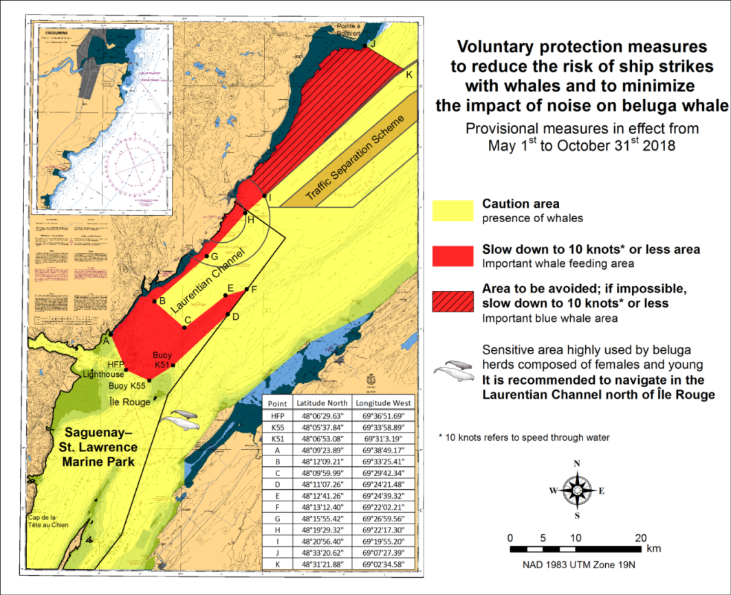
SAGUENAY–ST. LAWRENCE MARINE PARK AND SURROUNDING WATERS – WHALE PROTECTION
The waters in and around the Saguenay–St. Lawrence Marine Park are well known for the resident endangered beluga population and the wide diversity of whales that migrate there to feed, particularly between April and November.
REGULATORY PROTECTION MEASURES
All whale species that are found in the St. Lawrence are protected under the Marine Mammal Regulations, pursuant to the Fisheries Act. Within the boundaries of the Marine Park, specific measures are set out in the Marine Activities in the Saguenay–St. Lawrence Marine Park Regulations, pursuant to the Act Establishing the Saguenay–St. Lawrence Marine Park. Any collision with a marine mammal within the Marine Park must immediately be reported to a park warden at 1-866-508-9888. For collisions that occur outside the Marine Park or for any situation involving a marine mammal that is dead or in trouble, contact the emergency network at 1-877-722-5346 or on channel 16.
For more information on the Saguenay–St. Lawrence Marine Park, see notice 5C of the Notices to Mariners Annual Edition 2018.
VOLUNTARY PROTECTION MEASURES
Provisional measures in effect from May 1st to October 31st, 2018. See map at the end of this notice.
These measures apply to merchant vessels and cruise ships between Pointe à Boisvert and Cap de la Tête au Chien to prevent collisions with whales. These measures should only be taken when they will not jeopardize navigational safety.
Caution area (yellow area): To reduce the risk of collisions with whales that can be present anywhere in this area, heightened vigilance of navigators is critical. Posting a lookout is recommended in order to increase the chances of seeing the whales and thus taking necessary measures to avoid them. If bypassing the whales is not possible, slow down and wait for the animals to move away to a distance greater than 400 meters (0.215 nautical miles) before resuming original speed. It is more difficult to see the animals at night, therefore increased caution is recommended.
Slow down to 10 knots or less area (red area): To reduce the risk of collisions with whales in this feeding area, it is recommended that vessels slow down to a maximum speed through the water of 10 knots and post a lookout. It is further recommended to remain in the Laurentian Channel to the north of Île Rouge to minimize the impact of noise in a sensitive area south of this island, which is highly frequented by herds of beluga whales composed of females and young.
Area to be avoided (hatched red area): To reduce noise and the risk of collisions with whales, vessels should avoid transiting through this area which is highly frequented by blue whales, an endangered species. If the area cannot be avoided, slow down to a speed through the water of 10 knots or less.
GULF OF ST. LAWRENCE - PROTECTION OF THE NORTH ATLANTIC RIGHT WHALE
Due to the changing migratory habits of the North Atlantic Right whale and their increased presence in the Gulf of St. Lawrence, the Government of Canada has put in place seasonal speed restrictions in specified areas. These restrictions are a combination of static zone and dynamic speed reduction sectors. (See map below.)
These measures are in effect from April 28 to November 15, 2018. These dates are subject to change dependent on North Atlantic Right whale presence. Once the mandatory speed restriction has been lifted, vessels are asked to voluntarily reduce their speed to not exceed 10.0 knots over the ground in the presence of North Atlantic Right whales only if maritime conditions permit safe operation of their vessel at that speed.
Static zone coordinates: 47° 10'N 062°
00'W; 47° 10'N 065° 00'W; 50° 20'N 065° 00'W; 50° 20'N 063°
00'W;
49° 43’N 063° 00’W and
49° 04’N 062° 00’W
Within the static zone, with the exclusion of the dynamic sector corridor, vessels 20 m or more in length are required to operate at a speed not exceeding 10.0 knots over the ground during the above specified dates.
Dynamic sector coordinates:
Sector A) 49° 41’N 065° 00’W; 49° 20’N
065° 00’W; 49° 11’N 064° 00’W; 49° 22’N 064°
00’W;
Sector B)
49° 22’N 064° 00’W; 49° 11’N 064° 00’W; 48° 48’N 063°
00’W; 49° 00’N 063° 00’W;
Sector C) 49° 00’N 063°
00’W; 48° 48’N 063° 00’W; 48° 24’N
062° 00’W; 48° 35’N 062° 00’W;
and
Sector D)
50° 06’N 064° 00’W; 50° 00’N 064°
00’W; 49° 56’N 063° 00’W; 50° 03’N
063° 00’W.
Within the static zone, there are four dynamic sectors: A, B, C and D. Within these sectors, vessels may proceed at a safe operational speed when the Government of Canada has determined that whales do not appear to be present. When North Atlantic Right whale presence has been determined inside a dynamic sector, vessels 20 m or more in length will be notified through a Notice to Shipping (NOTSHIP) and are required to reduce their speed to not exceed 10.0 knots over the ground within that sector.
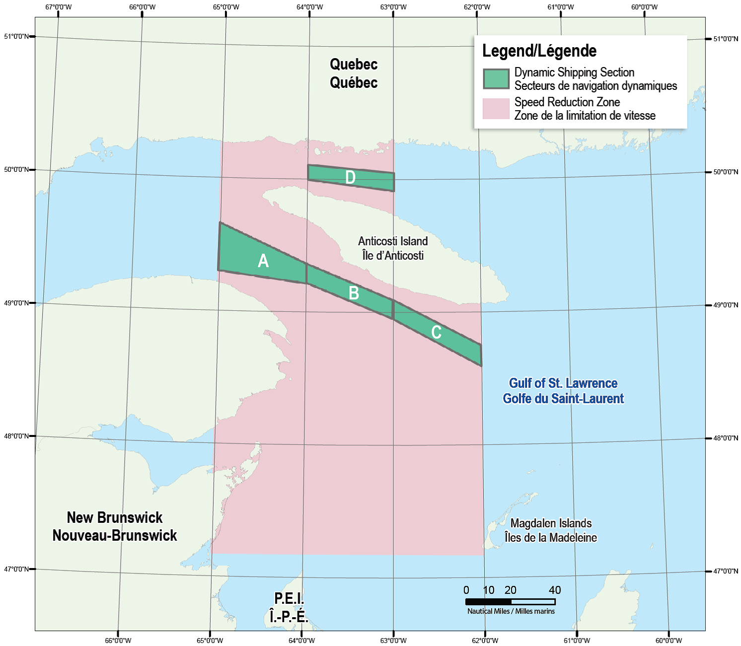
Speed restrictions within the dynamic sectors (A, B, C and D) will be in effect for 15 days, from the date of issuance, and can be extended in the event of continued whale presence. The establishment of speed reduction zones and sectors will be announced through NOTSHIPs.
NOTSHIP Broadcasts
The Canadian Coast Guard (CCG) continues to promulgate valid NOTSHIPs via radio broadcasts over various terrestrial systems and also online at http://www.ccg-gcc.gc.ca/navigating-hub. Mariners shall ensure that they have correct and up-to-date information concerning the protection of the North Atlantic Right whales as contained in all applicable Notices to Mariners (NOTMARs) and NOTSHIPs.
Aids to Navigation
In addition, CCG is testing the use of virtual AIS aids to navigation (AIS AtoN), NOTMAR 819(T)/2016 refers, which will notify a mariner of a dynamic sector that is subject to a speed reduction. Each dynamic sector will be delimited by four virtual AIS AtoN which could be displayed on ship’s navigation equipment such as: ECDIS, ECS, RADAR, Minimum Keyboard Display, and Electronic Nautical Charts. The virtual AIS AtoN will be broadcasted only when speed reduction is in effect in one or more sectors. The mariner is required to select the virtual AIS AtoN symbol to view a message as such: “SectA1 Spd Lim 10 kt.” This message refers to a speed reduction in effect for a specific sector. As this system continues to be in the testing phase, it is not the primary means of communicating with the mariner.
Compliance and Enforcement
Failure to comply with mandatory speed restrictions could lead to enforcement action and subject to fines ranging from $6,000 Cdn to $25,000 Cdn. If vessels appear to have violated the speed restriction, Transport Canada Marine Safety Inspectors will review all information provided through AIS and seek information from the master.
Exemptions to the speed restrictions will not be granted in advance; however, factors such navigation to ensure vessel safety, weather conditions, and responding to emergencies, will be reviewed and considered.
Reporting of Whale Sightings
Mariners are requested to report all observations of entangled, dead, or injured whales to the nearest CCG Marine Communication and Traffic Services Centre; or as follows:
•For the southern part of the Gulf of St. Lawrence:
–Marine Animal Response Society at 1-866-567-6277
•For Newfoundland and Labrador:
–Whale Release and Strandings at 1-888-895-3003
•For the Québec sector:
–Marine Mammal emergencies at 1-877-722-5346.
Sightings of live, free-swimming whales should be reported by phone to 1-902-440-8611 or 1-844-800-8568 or by email: XMARWHALESIGHTINGS@DFO-MPO.GC.CA
SAGUENAY–ST. LAWRENCE MARINE PARK - BELUGA WHALE PROTECTION: SLOWDOWN AREA AT THE MOUTH OF THE SAGUENAY FJORD AND AREA CLOSURE AT BAIE SAINTE-MARGUERITE
The Saguenay–St. Lawrence Marine Park and its surrounding area are at the heart of endangered beluga whale critical summer habitat. Marine mammal protection measures have been put in place in accordance with the Marine Activities in the Saguenay–St. Lawrence Marine Park Regulations within the limits of the Marine Park. However, important feeding, calving and rearing areas for beluga whales require greater protection to ensure the recovery of the species. The portion of the Saguenay situated between the mouth of the Fjord and Baie Sainte-Marguerite is one of the areas most used by females and their young from May to October. The mouth of the Saguenay is known as a feeding ground, and Baie Sainte-Marguerite as a calving and rearing area.
In order to prevent collisions with beluga whales, a compulsory 15-knot slowdown area is in effect from May 1st to October 31st at the mouth of the Saguenay. To ensure tranquility for female belugas and their young during the critical calving period, access to Baie Sainte-Marguerite is prohibited to all vessels from June 21st to September 21st, except for special authorizations (see description below).
For safety reasons, these measures do not apply to cargo ships (see notice “Saguenay–St.Lawrence Marine Park and Surrounding Waters – Whale Protection” in the monthly edition of Notice to Mariners concerning voluntary protection measures in the St. Lawrence Estuary from May to October). An enhanced vigilance is however recommended to all navigators between the mouth of the Saguenay Fjord and Baie Sainte-Marguerite for the protection of beluga whales.
For more information on the Saguenay–St. Lawrence Marine Park, see notice 5C of the Notices to Mariners Annual Edition 2018 or visit http://parcmarin.qc.ca/home/.
SUMMARY OF REGULATORY PROTECTION MEASURES - BELUGA WHALE
Entire Marine Park Territory: When beluga whales are less than half a nautical mile (926 metres) from a motorized vessel, the vessel must maintain a speed of between 5 and 10 knots. All vessels, including human-powered vessels (kayaks and canoes), must continue to move forward and maintain their heading. All vessels must maintain a minimum distance of 400 metres from beluga whales at all times. For more information concerning the regulations, consult: http://marinepark.ca/protect/#regulations
Mouth of the Saguenay Fjord (Figure 1) - Slowdown Area (area cross-hatched in red): Maximum speed at the mouth of the Saguenay between buoys S7 and S8 and the ferry docks between Baie-Sainte-Catherine and Tadoussac is 15 knots from May 1st to October 31st.
Baie Sainte-Marguerite (Figure 2) - Area Closure (red area): From June 21st to September 21st, vessels must not enter the red area which follows a line between Cap Nord-Ouest and Cap Sainte-Marguerite.
Special authorizations are granted only for kayaks, canoes and recreational fishermen who must travel without stopping along a corridor (see dotted line, Figure 2) within 10 metres of the shore or in shallow areas.
VOLUNTARY PROTECTION MEASURES
Baie Sainte-Marguerite sector - Transit Area (area cross-hatched in yellow): From June 21st to September 21st, navigation in this area is recommended at a speed of between 5 and 10 knots without stopping.
The purpose of this transit area is to favour respect of the Marine Activities in the Saguenay–St. Lawrence Marine Park Regulations since beluga whales are often present in the Baie Sainte-Marguerite sector.
INFORMATION
All incidents, including collisions with whales, must be reported without delay by dialling 1-866-508-9888. For any other situation concerning a marine mammal that is either dead or in trouble, contact the emergency network at 1-877-722-5346, or use VHF channel 16.
Figure 1
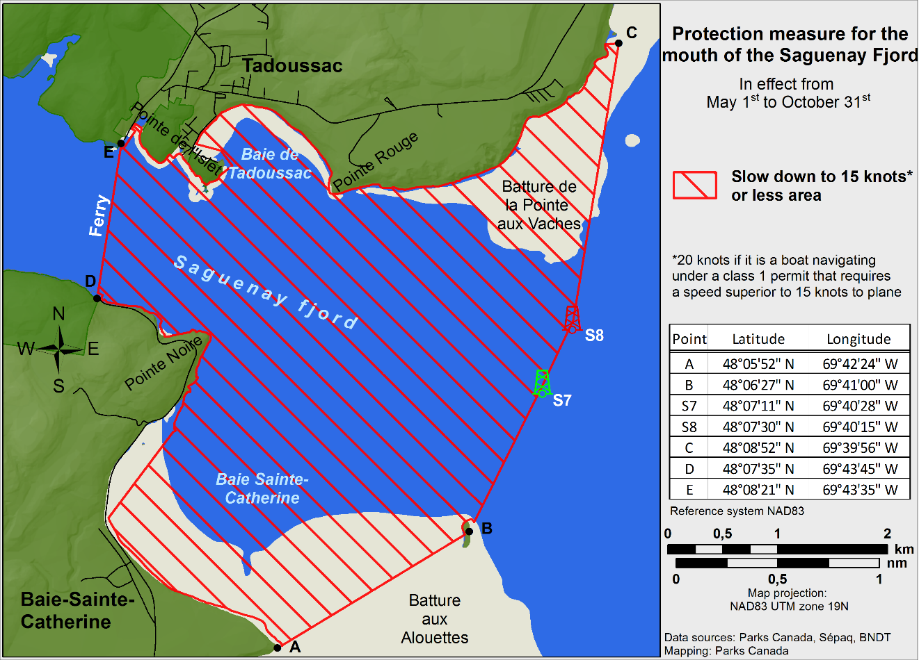
Figure 2

*701 CANADIAN HYDROGRAPHIC SERVICE – RASTER DIGITAL CHARTS (BSB V3)
|
CHARTS |
MAIN TITLE |
SCALE |
PUBLISHED |
|---|---|---|---|
|
New Editions |
|||
|
RM-7685 |
Tuktoyaktuk Harbour and Approaches/et les approches |
1:15 000 |
13-OCT-2017 |
*702 TRANSPORT CANADA – SHIP SAFETY BULLETIN #09/2018
This is to notify you that a new Ship Safety Bulletin has recently been posted to the Transport Canada website at www.tc.gc.ca/ssb-bsn/.
To go online to view or download this bulletin, please click on the link below:
SSB#09/2018 – Safe Operation of Commercial Passenger Vessels
RDIMS#14033737
Sign yourself up for e-Bulletin to receive an e-mail notice each time a new Ship Safety Bulletin is published on our Website.
Contact us at: marinesafety-securitemaritime@tc.gc.ca or 1-855-859-3123 (Toll Free).
*703 TRANSPORT CANADA – SHIP SAFETY BULLETINS (TP 3231) AND TRANSPORT PUBLICATIONS – 2018
Ship Safety Bulletins (TP 3231) – 2018
Ship Safety Bulletins address safety-related matters pertaining to vessels. Bulletins are available from Transport Canada’s Marine Safety Directorate free of charge and are issued on an "as needed" basis. A complete list of Ship Safety Bulletins is available on Transport Canada’s website at:
http://www.tc.gc.ca/eng/marinesafety/bulletins-menu.htm
If you do not have access to our website and wish to be included in the Ship Safety Bulletins mailing list, please send your request to the Marine Safety location provided below. We ask your cooperation in distributing copies of this listing to your colleagues, to ship owners and/or maritime companies to let them know of the existence of these Bulletins.
If this is the first time you are receiving the Bulletin, your name is probably not on Transport Canada’s mailing list. Should you wish to be included, please send your request to the Marine Safety location provided below.
How to Stay Up-to-Date on Newly Published Bulletins
To receive Ship Safety Bulletins electronically, select the following Internet address and follow the instructions on how to sign up for e-Bulletin or RSS feed services. E-Bulletin sends a notice to your e-mail address inbox, whereas RSS feed sends a notice to your Internet browser when a new Ship Safety Bulletin becomes available on our website at http://www.tc.gc.ca/eng/marinesafety/bulletins-menu.htm
As of June 29, 2018, the following Ship Safety Bulletins have been issued:
|
Bulletin No. |
Bulletin Title |
Date |
|---|---|---|
|
01/2018 |
How to Meet STCW Requirements for Masters, Deck Officers and Other Crew Members of Certain Canadian Ships Operating in Polar Waters |
2018-02-15 |
|
02/2018 |
Guidelines for Over-Wintering of Vessels Carrying Oil or NLS in Waters under Canadian Jurisdiction - TP 15295 |
2018-03-01 |
|
03/2018 |
Standards for the Construction, Inspection, and Operation of Barges Carrying Oil or Dangerous Chemicals in Bulk |
2018-03-02 |
|
04/2018 |
Marine Diesel Engines in Small Canadian Vessels |
2018-03-13 |
|
05/2018 |
Coming into force: New Arctic Shipping Safety and Pollution Prevention Regulations |
2018-04-17 |
|
06/2018 |
Protection of the North Atlantic Right Whale – Speed Restriction Measures in the Gulf of St. Lawrence |
2018-05-15 |
|
07/2018 |
Updates to the Canadian Ballast Water Reporting Form |
2018-06-01 |
|
08/2018 |
Loading/Unloading Ammonium Nitrate Based Fertilizers in Bulk |
2018-06-04 |
|
09/2018 |
Safe Operation of Commercial Passenger Vessels |
2018-06-25 |
Transport Publications (TPs) New and/or Updated – 2018
|
Publication No. |
Title |
Date |
|---|---|---|
|
TP 127 |
Ships Electrical Standards Updated |
2018 |
|
TP 12259 |
Arctic Ice Regime Shipping System (AIRSS) Standards Updated |
2018 |
|
TP 13617 |
A Guide to Canada’s Ballast Water Control and Management Regulations Updated |
2018 |
|
TP 13670 |
Guidelines for Passenger Vessels Operating in the Canadian Arctic Updated |
2017 |
|
TP 15211 |
Canadian Supplement to the SOLAS Convention Updated |
2017 |
|
TP 15356 |
Small Vessel Compliance Program (SVCP) Guidance Notes for the Detailed Compliance Report for Small Fishing Vessels not more than 15 Gross Tonnage Updated |
2018 |
Copies of these publications may be obtained from:
Transport Canada
Marine
Safety Directorate
(AMSIA)
Place de Ville, Tower
“C”
330 Sparks Street,
9th
floor
Ottawa, Ontario,
K1A 0N5
Website:Ship Safety Bulletins
http://www.tc.gc.ca/eng/marinesafety/bulletins-menu.htm
Transport Publications
http://www.tc.gc.ca/eng/marinesafety/tp-menu-515.htm
If you have questions, or require hardcopies of Ship Safety Bulletins or Transport Publications, contact Transport Canada Marine Safety Directorate by:
E-mail: .................................
marinesafety-securitemaritime@tc.gc.ca
Phone: ............................................................................
613-991-3135
Toll Free
(Marine): ........................................................
1-866-995-9737
Teletypewriter
(TTY): ....................................................
1-888-675-6863
Fax:
................................................................................
613-990-1879
*705 CANADIAN COAST GUARD PUBLICATION – AMENDMENTS TO NOTICES TO MARINERS ANNUAL EDITION 2018 - SECTION B, NOTICE 23: GENERAL INFORMATION ON PILOTAGE SERVICE
Page 10:
AMEND
|
NOVA SCOTIA |
|||||||
|---|---|---|---|---|---|---|---|
|
Compulsory areas |
|||||||
|
2. |
Halifax |
Pilots Halifax |
44 30 4 N 63 29 5 W |
12 |
3 |
Estimate – 12 Tentative – 5 Confirm – 1.5 |
12 |
|
… |
… |
… |
… |
… |
… |
… |
… |
|
Non-compulsory areas |
|||||||
|
1. |
Eastern Shore Halifax to Cape Canso |
Pilots Halifax |
Off Halifax 44 30 4 N 63 29 5 W (or local boarding by previous arrangement) |
24 |
6 |
6 |
12 |
|
Country Harbour |
Pilots Halifax |
45 02 00 N 61 33 00 W |
24 |
6 |
6 |
16 |
|
|
Sheet Harbour |
Pilots Halifax |
44 30 4 N 62 29 5 W (or local boarding by previous arrangement) |
24 |
6 |
6 |
16 |
|
TO READ
|
NOVA SCOTIA |
|||||||
|---|---|---|---|---|---|---|---|
|
Compulsory areas |
|||||||
|
2. |
Halifax |
Pilots Halifax |
44 30 24 N 63 29 30 W |
12 |
3 |
Estimate – 12 Tentative – 5 Confirm – 1.5 |
12 |
|
… |
… |
… |
… |
… |
… |
… |
… |
|
Non-compulsory areas |
|||||||
|
1. |
Eastern Shore Halifax to Cape Canso |
Pilots Halifax |
Off Halifax 44 30 24 N 63 29 30 W (or local boarding by previous arrangement) |
24 |
6 |
6 |
12 |
|
Country Harbour |
Pilots Halifax |
45 02 00 N 61 33 00 W |
24 |
6 |
6 |
16 |
|
|
Sheet Harbour |
Pilots Halifax |
Off Halifax 44 30 24 N 63 29 30 W (or local boarding by previous arrangement) |
24 |
6 |
6 |
16 |
|
Page 11:
AMEND
|
NOVA SCOTIA |
|||||||
|---|---|---|---|---|---|---|---|
|
Non-compulsory areas |
|||||||
|
4. |
Lunenburg |
Pilots Halifax |
Off Halifax 44 30 4 N 63 29 5 W or La Have River 44 15 00 N 64 19 00 W (as arranged) |
24 |
6 |
4 |
12 16 |
|
5. |
Mahone Bay/ St. Margarets |
Pilots Halifax |
Off Halifax 44 30 4 N 63 29 5 W or La Have River 44 15 00 N 64 19 00 W (as arranged) |
24 |
3 |
4 |
12 16 |
TO READ
|
NOVA SCOTIA |
|||||||
|---|---|---|---|---|---|---|---|
|
Non-compulsory areas |
|||||||
|
4. |
Lunenburg |
Pilots Halifax |
Off Halifax 44 30 24 N 63 29 30 W or La Have River 44 15 00 N 64 19 00 W (as arranged) |
24 |
6 |
4 |
12 16 |
|
5. |
Mahone Bay/ St. Margarets |
Pilots Halifax |
Off Halifax 44 30 24 N 63 29 30 W or La Have River 44 15 00 N 64 19 00 W (as arranged) |
24 |
3 |
4 |
12 16 |
*706 CANADIAN COAST GUARD - LIST OF CHARTS AND REFERENCE CHARTS (SECTION 1) AFFECTED BY TEMPORARY AND PRELIMINARY NOTICES
IN EFFECT JULY 27th, 2018
(REVISED AND PROMULGATED QUARTERLY)
|
1430 |
409(P)/18 |
4244 |
1006(T)/14 |
|
1432 |
107(P)/17 |
4266 |
309(P)/18 |
|
2017 |
909(T)/14 709(T)/18 |
4302 |
906(P)/17 907(P)/17 |
|
2044 |
1005(T)/15 |
4307 |
908(P)/17 |
|
2060 |
814(T)/16 |
4377 |
405(P)/13 |
|
2067 |
1218(T)/16 |
4426 |
310(P)/18 |
|
2077 |
1011(T)/16 |
4459 |
208(P)/18 |
|
2085 |
1205(T)/17 509(T)/18 510(T)/18 512(T)/18 710(T)/18 |
4460 |
311(P)/18 312(P)/18 |
|
2086 |
1219(T)/16 |
4466 |
313(P)/18 314(P)/18 |
|
2123 |
309(T)/17 |
4491 |
1007(P)/17 |
|
2181 |
108(T)/17 |
4523 |
209(P)/18 |
|
2204 |
609(P)/18 |
4587 |
413(P)/18 |
|
2235 |
818(T)/16 |
4591 |
210(P)/18 |
|
2315 |
515(T)/16 |
4642 |
315(P)/18 |
|
3479 |
617(P)/17 |
4644 |
1106(T)/15 |
|
3513 |
410(P)/18 |
4826 |
707(P)/18 |
|
3540 |
411(P)/18 |
4865 |
415(P)/18 |
|
3624 |
1116(P)/16 |
4909 |
613(P)/12 |
|
3646 |
611(P)/18 |
4911 |
811(P)/12 510(P)/15 |
|
3671 |
620(P)/17 |
4913 |
518(P)/16 |
|
3675 |
1118(P)/16 |
4920 |
507(P)/18 |
|
3679 |
1121(P)/16 |
4970 |
708(P)/18 |
|
3681 |
1122(P)/16 |
5047 |
416(P)/18 |
|
3686 |
1123(P)/16 |
6022 |
1206(T)/17 |
|
3890 |
1108(P)/17 |
6218 |
204(T)/16 |
|
4010 |
608(P)/17 |
6242 |
113(T)/18 417(P)/18 418(P)/18 |
|
4116 |
205(P)/18 |
6267 |
114(T)/18 |
|
4117 |
206(P)/18 |
6287 |
113(T)/17 |
|
4234 |
610(P)/18 |
14853 (U.S.) |
808(P)/17 |
|
4236 |
610(P)/15 412(P)/18 |
*707(P) BURGEO TO / À FRANÇOIS – LIGHT TO BE DISCONTINUED
Reference Chart: 4826
The Canadian Coast Guard proposes to permanently discontinue the following aid to navigation:
New Harbour Island (LL 136) (47° 35’ 55.7”N 056° 39’ 41.2”W)
Comments on this action are solicited from mariners and other interested parties by October 27th, 2018, three months following the initial publication date of July 27th, 2018. Comments should be directed to the following:
Superintendent, Renee
Pope
Aids to Navigation and
Waterways
Canadian Coast Guard
P.O. Box 5667
St. John’s, NL A1C 5X1
Telephone: (709)
772-2800
Email:
renee.pope@dfo-mpo.gc.ca
Any objections raised must state the facts on which they are based and should include supporting information on safety, commerce and public benefit.
(N2018-050)
*708(P) BAIE DE BONNE-ESPÉRANCE À/TO ÎLE MISTANOQUE – NOTICE OF PROPOSED CHANGES
Reference Chart: 4970
The Canadian Coast Guard proposes to permanently change the following aids to navigation:
To discontinue the Chenal du Vieux Fort range lights (LL 1539.1 and LL 1539.12), which operates at night only, and replace it by a sector light located on the front range site at position 51° 23’ 51.89”N 057° 48’ 13.06”W. This new sector light would have a nominal range of 18 nautical miles.
The arcs of visibility (true bearing) would be the following:
Red sector: from 010° to 009.25°
White sector: from 012° to 010°
Green sector: from 12.75° to 12°
The change would be effective in the fall of 2018.
Comments on this action are solicited from mariners and other interested parties by October 27th, 2018, three months following the initial publication date of July 27th, 2018. Comments should be directed to the following:
Superintendent,
Lise Richard
Aids to Navigation &
Waterways
Central & Arctic
Region
Canadian Coast
Guard
101 boulevard
Champlain
Québec, QC G1K
7Y7
Telephone: (418)
648-7450
Email:
lise.richard@dfo-mpo.gc.ca
Any objections raised must state the facts on which they are based and should include supporting information on safety, commerce and public benefit.
(Q2018-125)
*709(T) KINGSTON HARBOUR AND APPROACHES/ET LES APPROCHES – INFORMATION REGARDING MOORING AND ANCHORING
Reference: Notice 309(T)/14 is cancelled.
Reference Chart: 2017
All mooring or anchoring within the public port of Kingston is prohibited outside of designated marina areas until further notice without authorization from the port official.
Inquiries are to be directed to Transport Canada at (416) 952-0475.
*710(T) TORONTO HARBOUR – CONSTRUCTION OPERATIONS
Reference Chart: 2085
Construction operations taking place daily from 1100 UTC to 2300 UTC until December 2018 north of Pier 34. Tug D.L. Stanyar and 5 barges on scene. Width of Keating Channel reduced due to operations.
Mariners are requested to keep out of the construction zone, minimize their wake and to follow directions from the Toronto Police Service Marine Unit.
(NOTSHIP C564/18)
*711 PORT SEVERN TO/À PARRY SOUND – UNLIT BUOYS PERMANENTLY DISCONTINUED
Reference: Notice 109(P)/17 is cancelled (Chart 2202).
(D2018-002 to D2018-010)
*712 TRYON SHOALS TO / À CAPE EGMONT – LIGHT BUOYS PERMANENTLY DISCONTINUED
Reference: Notice 207(P)/18 is cancelled (Chart 4406).
(G2018-070, 071)
*713 TORONTO HARBOUR – OFFLOADING IN A CONSTRUCTION ZONE
Reference: Notice 511(T)/18 is cancelled (Chart 2085).
Please refer to NOTSHIP C1351/18 for more information about the stone delivery offloading.
(NOTSHIP C1351/18)
SECTION 2 - CHART CORRECTIONS
1236 - Pointe des Monts aux/to Escoumins - New Edition - 26-OCT-2012 - NAD 1983
| 06-JUL-2018 | LNM/D. 29-JUN-2018 | ||
| Add |
drying height of 0 metres 1 decimetre (See Chart No. 1, I15) This notice affects Electronic Navigational Chart: CA279037 |
48°33′07.3″N 068°21′59.2″W | |
| DFO(6409888-01) | |||
| Add |
drying height of 0 metres 2 decimetres (See Chart No. 1, I15) This notice affects Electronic Navigational Chart: CA279037 |
48°35′47.5″N 068°16′29.4″W | |
| DFO(6409888-02) | |||
| Add |
depth of 2 metres 3 decimetres (See Chart No. 1, I10) This notice affects Electronic Navigational Chart: CA279037 |
48°38′56.8″N 068°08′16.4″W | |
| DFO(6409888-03) |
1236 - Rimouski - New Edition - 26-OCT-2012 - NAD 1983
| 06-JUL-2018 | LNM/D. 29-JUN-2018 | ||
| Affix |
patch Download Patch - ftp://ftp.dfo-mpo.gc.ca/patches/pa1236-20180606.pdf This notice affects Electronic Navigational Chart: CA579041 |
48°30′40.0″N 068°28′54.0″W | |
| DFO(6409889-01) |
1512 - Ottawa to/à Long Island - Sheet/Feuille 1 - New Edition - 04-MAR-2005 - NAD 1983
| 06-JUL-2018 | LNM/D. 19-MAY-2017 | ||
| Add |
green port hand spar buoy, marked N17 (See Chart No. 1, Qg) |
45°21′40.9″N 075°41′29.8″W | |
| (B2016012) DFO(6604418-01) | |||
| Reposition |
red starboard hand spar buoy, marked N20 (See Chart No. 1, Qf) |
from 45°21′36.4″N 075°41′26.2″W to 45°21′36.2″N 075°41′26.9″W |
|
| (B2016010) DFO(6604418-02) | |||
| Delete |
depth of 17 feet (See Chart No. 1, I10) |
45°21′35.6″N 075°41′26.2″W | |
| DFO(6604418-03) |
2202 - Port Severn to/à Penetang Harbour - Sheet/Feuille 1 - New Edition - 05-JAN-2007 - NAD 1983
| 13-JUL-2018 | LNM/D. 05-JUN-2015 | ||
| Add |
underwater rock of unknown depth, dangerous to surface
navigation, Rep (2018) (See Chart No. 1, K13) This notice affects Electronic Navigational Chart: CA473271 |
44°45′20.4″N 079°47′48.0″W | |
| DFO(6604426-01) |
2202 - Port Severn to/à Tomahawk Island - Sheet/Feuille 1 - New Edition - 05-JAN-2007 - NAD 1983
| 13-JUL-2018 | LNM/D. 05-JUN-2015 | ||
| Delete | yellow cautionary can buoy, marked A | 44°47′07.8″N 079°44′02.8″W | |
| (D2018002) DFO(6604402-01) | |||
| Delete | yellow cautionary can buoy, marked B | 44°47′36.3″N 079°47′55.8″W | |
| (D2018003) DFO(6604403-01) | |||
| Delete | yellow cautionary can buoy, marked C | 44°48′52.7″N 079°47′54.3″W | |
| (D2018004) DFO(6604404-01) | |||
| Delete | yellow cautionary can buoy, marked D | 44°50′51.8″N 079°49′03.0″W | |
| (D2018005) DFO(6604405-01) | |||
| Delete | white and orange information can buoy, marked LOW WATER | 44°47′10.0″N 079°44′02.4″W | |
| (D2018006) DFO(6604406-01) | |||
| Delete | white and orange information spar buoy, marked LOW WATER | 44°47′20.4″N 079°43′46.8″W | |
| (D2018007) DFO(6604407-01) | |||
| Delete | white and orange information can buoy, marked LOW WATER | 44°48′56.0″N 079°47′52.3″W | |
| (D2018008) DFO(6604408-01) | |||
| Delete | white and orange information can buoy, marked LOW WATER | 44°47′35.4″N 079°47′55.8″W | |
| (D2018009) DFO(6604409-01) | |||
| Delete | white and orange information can buoy, marked LOW WATER | 44°50′51.2″N 079°49′02.0″W | |
| (D2018010) DFO(6604410-01) | |||
| Add |
submarine power cable (See Chart No. 1, L31.1) This notice affects Electronic Navigational Chart: CA473297 |
joining 44°55′04.0″N 079°50′20.1″W 44°55′04.2″N 079°50′18.3″W 44°55′04.7″N 079°50′13.4″W and 44°55′06.0″N 079°50′07.5″W |
|
| DFO(6604419-01) |
2202 - Tomahawk Island to/à Twelve Mile Bay - Sheet/Feuille 2 - New Edition - 05-JAN-2007 - NAD 1983
| 13-JUL-2018 | LNM/D. 05-JUN-2015 | ||
| Add |
submarine power cable (See Chart No. 1, L31.1) This notice affects Electronic Navigational Chart: CA473297 |
joining 44°55′04.0″N 079°50′20.1″W 44°55′04.2″N 079°50′18.3″W 44°55′04.7″N 079°50′13.4″W and 44°55′06.0″N 079°50′07.5″W |
|
| DFO(6604419-01) |
2223 - Port McNicoll and/et Victoria Harbour - New Chart - 13-APR-1984 - NAD 1927
| 13-JUL-2018 | LNM/D. 04-AUG-2006 | ||
| Add |
underwater rock of unknown depth, dangerous to surface
navigation, Rep (2018) (See Chart No. 1, K13) This notice affects Electronic Navigational Chart: CA473271 |
44°45′20.4″N 079°47′48.0″W | |
| DFO(6604426-01) |
2241 - Port Severn to/à Christian Island - New Chart - 30-JUL-1999 - NAD 1983
| 13-JUL-2018 | LNM/D. 30-NOV-2012 | ||
| Add |
underwater rock of unknown depth, dangerous to surface
navigation, Rep (2018) (See Chart No. 1, K13) This notice affects Electronic Navigational Chart: CA473271 |
44°45′20.4″N 079°47′48.0″W | |
| DFO(6604426-01) |
4003 - Cape Breton to / à Cape Cod - New Edition - 21-MAR-2003 - NAD 1983
| 27-JUL-2018 | LNM/D. 29-JUN-2018 | ||
| Add |
subsurface Ocean Data Acquisition System ODAS/SADO with
known depth of 49 fathoms (See Chart No. 1, L25) This notice affects Electronic Navigational Chart: CA276206 |
43°00′09.3″N 065°33′55.2″W | |
| DFO(6308322-01) | |||
| Add |
subsurface Ocean Data Acquisition System ODAS/SADO with
known depth of 48 fathoms (See Chart No. 1, L25) This notice affects Electronic Navigational Chart: CA176140, CA276801 |
43°29′51.4″N 062°52′11.9″W | |
| DFO(6308323-01) |
4010 - Bay of Fundy / Baie de Fundy: Inner portion / partie intérieure - New Edition - 14-FEB-2003 - NAD 1983
| 13-JUL-2018 | LNM/D. 19-MAY-2017 | ||
| Amend |
Fl R to read Iso R against light (See Chart No. 1, P16) This notice affects Electronic Navigational Chart: CA376011, CA576005 |
45°15′27.0″N 066°02′40.0″W | |
| (F2018023) LL(104) DFO(6308361-01) |
4011 - Approaches to / Approches à Bay of Fundy / Baie de Fundy - New Edition - 03-JAN-2003 - NAD 1983
| 27-JUL-2018 | LNM/D. 23-FEB-2018 | ||
| Add |
subsurface Ocean Data Acquisition System ODAS/SADO with
known depth of 89 metres (See Chart No. 1, L25) This notice affects Electronic Navigational Chart: CA276206 |
43°00′09.3″N 065°33′55.2″W | |
| DFO(6308322-01) |
4012 - Yarmouth to / à Halifax - New Edition - 14-FEB-2003 - NAD 1983
| 27-JUL-2018 | LNM/D. 29-JUN-2018 | ||
| Add |
subsurface Ocean Data Acquisition System ODAS/SADO with
known depth of 89 metres (See Chart No. 1, L25) This notice affects Electronic Navigational Chart: CA276206 |
43°00′09.3″N 065°33′55.2″W | |
| DFO(6308322-01) | |||
| Add |
subsurface Ocean Data Acquisition System ODAS/SADO with
known depth of 87 metres (See Chart No. 1, L25) This notice affects Electronic Navigational Chart: CA176140, CA276801 |
43°29′51.4″N 062°52′11.9″W | |
| DFO(6308323-01) | |||
| Reposition |
light Fl 18m7M (See Chart No. 1, P1) This notice affects Electronic Navigational Chart: CA276800, CA376045, CA476202 |
from 44°02′01.1″N 064°37′41.8″W to 44°02′03.5″N 064°37′42.5″W |
|
| (F2018021) LL(407) DFO(6308352-01) | |||
| Amend |
Fl 18m7M to read Fl 4s15m7M against light (See Chart No. 1, P16) This notice affects Electronic Navigational Chart: CA276800, CA376045, CA476202 |
44°02′03.5″N 064°37′42.5″W | |
| (F2018021) LL(407) DFO(6308352-02) |
4026 - Havre Saint-Pierre et/and Cap des Rosiers à/to Pointe des Monts - New Edition - 23-MAY-2014 - NAD 1983
| 20-JUL-2018 | LNM/D. 24-NOV-2017 | ||
| Delete |
depth of 11 metres 9 decimetres (See Chart No. 1, I10) This notice affects Electronic Navigational Chart: CA279044, CA379026 |
50°16′22.9″N 063°55′49.6″W | |
| DFO(6409863-01) | |||
| Add |
depth of 11 metres 4 decimetres (See Chart No. 1, I10) This notice affects Electronic Navigational Chart: CA279044, CA379026 |
50°16′22.8″N 063°55′48.4″W | |
| DFO(6409863-02) |
4116 - Approaches to / Approches à Saint John - New Edition - 31-AUG-2007 - NAD 1983
| 13-JUL-2018 | LNM/D. 30-MAR-2018 | ||
| Replace |
depth of 1.8 metres with depth of 0.1 metres (See Chart No. 1, I10) This notice affects Electronic Navigational Chart: CA376011, CA576005 |
45°15′21.0″N 066°03′40.0″W | |
| DFO(6308332-05) | |||
| Amend |
Fl R to read Iso R against light (See Chart No. 1, P16) This notice affects Electronic Navigational Chart: CA376011, CA576005 |
45°15′26.4″N 066°02′42.2″W | |
| (F2018023) LL(104) DFO(6308361-01) |
4117 - Saint John Harbour and Approaches / et les approches - New Edition - 29-MAY-2009 - NAD 1983
| 13-JUL-2018 | LNM/D. 13-APR-2018 | ||
| Replace |
depth of 4.2 metres with depth of 0.1 metres (See Chart No. 1, I10) This notice affects Electronic Navigational Chart: CA576005 |
45°16′21.0″N 066°02′38.1″W | |
| DFO(6308331-01) | |||
| Delete |
depth of 0.9 metres (See Chart No. 1, I10) This notice affects Electronic Navigational Chart: CA576005 |
45°15′14.6″N 066°03′39.2″W | |
| DFO(6308332-01) | |||
| Replace |
depth of 0.7 metres with depth of 0.1 metres (See Chart No. 1, I10) This notice affects Electronic Navigational Chart: CA576005 |
45°15′24.9″N 066°03′39.9″W | |
| DFO(6308332-02) | |||
| Replace |
depth of 2.1 metres with depth of 0.1 metres (See Chart No. 1, I10) This notice affects Electronic Navigational Chart: CA576005 |
45°16′23.4″N 066°04′02.9″W | |
| DFO(6308332-03) | |||
| Add |
depth of 0.1 metres (See Chart No. 1, I10) This notice affects Electronic Navigational Chart: CA576005 |
45°15′14.9″N 066°03′37.3″W | |
| DFO(6308332-04) | |||
| Replace |
depth of 1.8 metres with depth of 0.1 metres (See Chart No. 1, I10) This notice affects Electronic Navigational Chart: CA376011, CA576005 |
45°15′21.0″N 066°03′40.0″W | |
| DFO(6308332-05) | |||
| Replace |
depth of 2.9 metres with depth of 0.4 metres (See Chart No. 1, I10) This notice affects Electronic Navigational Chart: CA576005 |
45°16′24.6″N 066°04′04.4″W | |
| DFO(6308332-06) | |||
| Replace |
depth of 3.7 metres with depth of 0.8 metres (See Chart No. 1, I10) This notice affects Electronic Navigational Chart: CA576005 |
45°15′10.0″N 066°03′35.3″W | |
| DFO(6308332-07) | |||
| Replace |
depth of 3.3 metres with depth of 1.9 metres (See Chart No. 1, I10) This notice affects Electronic Navigational Chart: CA576005 |
45°16′20.5″N 066°02′15.7″W | |
| DFO(6308332-08) | |||
| Replace |
depth of 3.7 metres with depth of 2.3 metres (See Chart No. 1, I10) This notice affects Electronic Navigational Chart: CA576005 |
45°15′03.8″N 066°03′31.9″W | |
| DFO(6308332-09) | |||
| Replace |
depth of 7 metres with depth of 2.9 metres (See Chart No. 1, I10) This notice affects Electronic Navigational Chart: CA576005 |
45°15′52.7″N 066°04′19.7″W | |
| DFO(6308332-10) | |||
| Replace |
depth of 9.2 metres with depth of 3.9 metres (See Chart No. 1, I10) This notice affects Electronic Navigational Chart: CA576005 |
45°14′33.1″N 066°02′57.2″W | |
| DFO(6308332-11) | |||
| Replace |
depth of 6 metres with depth of 3.9 metres (See Chart No. 1, I10) This notice affects Electronic Navigational Chart: CA576005 |
45°16′22.3″N 066°02′13.5″W | |
| DFO(6308332-13) | |||
| Delete |
depth of 6.1 metres (See Chart No. 1, I10) This notice affects Electronic Navigational Chart: CA576005 |
45°16′23.8″N 066°02′10.9″W | |
| DFO(6308332-14) | |||
| Amend |
Fl R to read Iso R against light (See Chart No. 1, P16) This notice affects Electronic Navigational Chart: CA376011, CA576005 |
45°15′26.4″N 066°02′42.2″W | |
| (F2018023) LL(104) DFO(6308361-01) |
4142 - Washademoak Lake - Sheet/Feuille 3 - New Edition - 01-NOV-1996 - NAD 1983
| 20-JUL-2018 | LNM/D. 20-OCT-2017 | ||
| Add |
red starboard hand spar buoy, marked D6/2 (See Chart No. 1, Qf) |
45°46′15.5″N 065°58′30.7″W | |
| (F2018022) DFO(6308360-01) |
4211 - Cape Lahave to / à Liverpool Bay - New Edition - 20-JUN-2003 - NAD 1983
| 27-JUL-2018 | LNM/D. 05-AUG-2016 | ||
| Reposition |
light Fl 4s 61ft 7M (See Chart No. 1, P1) This notice affects Electronic Navigational Chart: CA276800, CA376045, CA476202 |
from 44°02′01.1″N 064°37′41.8″W to 44°02′03.5″N 064°37′42.5″W |
|
| (F2018021) LL(407) DFO(6308352-01) | |||
| Amend |
Fl 4s 61ft 7M to read Fl 4s49ft7M against light (See Chart No. 1, P16) This notice affects Electronic Navigational Chart: CA276800, CA376045, CA476202 |
44°02′03.5″N 064°37′42.5″W | |
| (F2018021) LL(407) DFO(6308352-02) |
4240 - Liverpool Harbour to / à Lockeport Harbour - New Chart - 06-OCT-1989 - NAD 1983
| 27-JUL-2018 | LNM/D. 11-AUG-2017 | ||
| Reposition |
light Fl 4s 18m 7M (See Chart No. 1, P1) This notice affects Electronic Navigational Chart: CA276800, CA376045, CA476202 |
from 44°02′01.1″N 064°37′41.8″W to 44°02′03.5″N 064°37′42.5″W |
|
| (F2018021) LL(407) DFO(6308352-01) | |||
| Amend |
Fl 4s 18m 7M to read Fl 4s15m7M against light (See Chart No. 1, P16) This notice affects Electronic Navigational Chart: CA276800, CA376045, CA476202 |
44°02′03.5″N 064°37′42.5″W | |
| (F2018021) LL(407) DFO(6308352-02) |
4302 - Strait of Canso - New Chart - 28-SEP-2012 - NAD 1983
| 20-JUL-2018 | LNM/D. 13-OCT-2017 | ||
| Amend |
FY 14m15M to read FG 14m15M against light (See Chart No. 1, P16) This notice affects Electronic Navigational Chart: CA476678 |
45°32′21.7″N 061°18′53.2″W | |
| (G2018068) LL(690.3) DFO(6308314-01) | |||
| Amend |
FY 21m15M to read FG 21m15M against light (See Chart No. 1, P16) This notice affects Electronic Navigational Chart: CA476678 |
45°32′21.6″N 061°18′57.6″W | |
| (G2018069) LL(690.4) DFO(6308315-01) |
4307 - Canso Harbour to / au Strait of Canso - New Edition - 04-JAN-2008 - NAD 1983
| 20-JUL-2018 | LNM/D. 11-AUG-2017 | ||
| Amend |
FY 45ft to read FG 45ft against light (See Chart No. 1, P16) This notice affects Electronic Navigational Chart: CA476678 |
45°32′21.7″N 061°18′53.2″W | |
| (G2018068) LL(690.3) DFO(6308314-01) | |||
| Amend |
FY 68ft to read FG 68ft against light (See Chart No. 1, P16) This notice affects Electronic Navigational Chart: CA476678 |
45°32′21.6″N 061°18′56.5″W | |
| (G2018069) LL(690.4) DFO(6308315-01) |
4335 - Strait of Canso and Approaches / et les approches - New Edition - 04-JAN-2008 - NAD 1983
| 20-JUL-2018 | LNM/D. 11-AUG-2017 | ||
| Amend |
FY to read FG against light (See Chart No. 1, P16) This notice affects Electronic Navigational Chart: CA476678 |
45°32′21.0″N 061°18′52.0″W | |
| (G2018068) LL(690.3) DFO(6308314-01) | |||
| Amend |
FY to read FG against light (See Chart No. 1, P16) This notice affects Electronic Navigational Chart: CA476678 |
45°32′21.0″N 061°18′56.0″W | |
| (G2018069) LL(690.4) DFO(6308315-01) |
4379 - Liverpool Harbour - New Edition - 18-JUL-2003 - NAD 1983
| 27-JUL-2018 | LNM/D. 25-JUL-2014 | ||
| Reposition |
light Fl 4s 61ft 7M (See Chart No. 1, P1) This notice affects Electronic Navigational Chart: CA276800, CA376045, CA476202 |
from 44°02′01.1″N 064°37′41.8″W to 44°02′03.5″N 064°37′42.5″W |
|
| (F2018021) LL(407) DFO(6308352-01) | |||
| Amend |
Fl 4s 61ft 7M to read Fl 4s49ft7M against light (See Chart No. 1, P16) This notice affects Electronic Navigational Chart: CA276800, CA376045, CA476202 |
44°02′03.5″N 064°37′42.5″W | |
| (F2018021) LL(407) DFO(6308352-02) |
4385 - Chebucto Head to / à Betty Island - New Edition - 07-JUN-1996 - NAD 1983
| 13-JUL-2018 | LNM/D. 16-DEC-2016 | ||
| Add |
depth of 2 fathoms, 3 feet (See Chart No. 1, I10) |
44°26′34.5″N 063°31′34.0″W | |
| DFO(6307791-01) | |||
| Delete |
depth of 3 fathoms, 5 feet (See Chart No. 1, I10) |
44°27′24.8″N 063°32′52.8″W | |
| DFO(6307791-02) | |||
| Add |
depth of 2 fathoms, 4 feet (See Chart No. 1, I10) |
44°27′23.1″N 063°32′55.7″W | |
| DFO(6307791-03) | |||
| Replace |
depth of 4 fathoms, 4 feet with depth of 2 fathoms, 5
feet (See Chart No. 1, I10) |
44°26′50.8″N 063°32′40.9″W | |
| DFO(6307791-04) | |||
| Replace |
depth of 5 fathoms, 5 feet with depth of 4 fathoms, 4
feet (See Chart No. 1, I10) |
44°26′43.4″N 063°32′16.9″W | |
| DFO(6307791-05) | |||
| Replace |
depth of 4 fathoms with depth of 3 fathoms, 1 foot (See Chart No. 1, I10) |
44°26′43.2″N 063°32′26.2″W | |
| DFO(6307791-06) | |||
| Replace |
depth of 5 fathoms, 2 feet with depth of 2 fathoms, 5
feet (See Chart No. 1, I10) |
44°25′59.7″N 063°32′42.6″W | |
| DFO(6307791-07) | |||
| Delete |
depth of 4 fathoms, 4 feet (See Chart No. 1, I10) |
44°26′32.8″N 063°31′35.3″W | |
| DFO(6307791-08) | |||
| Replace |
depth of 5 fathoms with depth of 3 fathoms, 4 feet (See Chart No. 1, I10) |
44°26′13.9″N 063°32′54.7″W | |
| DFO(6307791-09) | |||
| Add |
depth of 3 fathoms, 1 foot (See Chart No. 1, I10) |
44°25′39.7″N 063°37′35.1″W | |
| DFO(6307791-10) | |||
| Replace |
depth of 3 fathoms, 3 feet with depth of 2 fathoms, 4
feet (See Chart No. 1, I10) |
44°26′21.3″N 063°37′36.8″W | |
| DFO(6307791-11) | |||
| Replace |
depth of 6 fathoms, 5 feet with depth of 5 fathoms, 0
feet (See Chart No. 1, I10) |
44°27′30.9″N 063°32′45.4″W | |
| DFO(6307791-12) | |||
| Replace |
depth of 6 fathoms, 4 feet with depth of 4 fathoms, 4
feet (See Chart No. 1, I10) |
44°27′13.2″N 063°38′47.8″W | |
| DFO(6307791-13) | |||
| Replace |
depth of 2 fathoms, 1 foot with depth of 1 fathom, 3
feet (See Chart No. 1, I10) |
44°27′15.1″N 063°38′57.0″W | |
| DFO(6307791-14) | |||
| Replace |
depth of 4 fathoms, 5 feet with depth of 1 fathom, 4
feet (See Chart No. 1, I10) |
44°27′44.9″N 063°39′00.4″W | |
| DFO(6307791-15) | |||
| Add |
depth of 2 fathoms, 5 feet (See Chart No. 1, I10) |
44°25′52.8″N 063°38′05.8″W | |
| DFO(6307791-16) | |||
| Replace |
depth of 2 fathoms, 4 feet with depth of 1 fathom, 5
feet (See Chart No. 1, I10) This notice affects Electronic Navigational Chart: CA476189 |
44°27′55.4″N 063°41′00.9″W | |
| DFO(6307884-01) | |||
| Replace |
depth of 4 fathoms, 5 feet with depth of 3 fathoms, 3
feet (See Chart No. 1, I10) This notice affects Electronic Navigational Chart: CA476189 |
44°27′50.7″N 063°40′25.4″W | |
| DFO(6307884-02) | |||
| Replace |
depth of 7 fathoms, 4 feet with depth of 4 fathoms, 1
foot (See Chart No. 1, I10) This notice affects Electronic Navigational Chart: CA476189 |
44°28′04.5″N 063°41′22.6″W | |
| DFO(6307884-03) | |||
| Add |
depth of 1 fathom, 4 feet (See Chart No. 1, I10) |
44°29′33.5″N 063°46′14.7″W | |
| DFO(6307884-04) | |||
| Replace |
depth of 3 fathoms, 4 feet with 2 fathoms, 0 feet (See Chart No. 1, I10) This notice affects Electronic Navigational Chart: CA476189 |
44°27′42.1″N 063°41′03.6″W | |
| DFO(6307884-05) | |||
| Replace |
depth of 6 fathoms, 3 feet with depth of 2 fathoms, 5
feet (See Chart No. 1, I10) This notice affects Electronic Navigational Chart: CA476189 |
44°26′34.9″N 063°42′00.0″W | |
| DFO(6307884-06) | |||
| Replace |
depth of 8 fathoms, 5 feet with depth of 5 fathoms, 2
feet (See Chart No. 1, I10) This notice affects Electronic Navigational Chart: CA476189 |
44°26′47.8″N 063°42′05.0″W | |
| DFO(6307884-07) | |||
| Replace |
depth of 6 fathoms with depth of 3 fathoms, 3 feet (See Chart No. 1, I10) This notice affects Electronic Navigational Chart: CA476189 |
44°27′03.3″N 063°42′17.3″W | |
| DFO(6307884-08) | |||
| Replace |
depth of 2 fathoms, 2 feet with depth of 1 fathom, 2
feet (See Chart No. 1, I10) |
44°25′57.1″N 063°39′10.0″W | |
| DFO(6307884-09) | |||
| Add |
depth of 3 fathoms, 2 feet (See Chart No. 1, I10) This notice affects Electronic Navigational Chart: CA476189 |
44°27′09.4″N 063°42′24.2″W | |
| DFO(6307884-10) | |||
| Delete |
depth of 4 fathoms, 3 feet (See Chart No. 1, I10) This notice affects Electronic Navigational Chart: CA476189 |
44°27′14.7″N 063°42′18.0″W | |
| DFO(6307884-11) | |||
| Add |
depth of 2 fathoms (See Chart No. 1, I10) This notice affects Electronic Navigational Chart: CA476189 |
44°27′13.9″N 063°42′20.2″W | |
| DFO(6307884-12) | |||
| Replace |
depth of 4 fathoms, 1 foot with depth of 1 fathom, 5
feet (See Chart No. 1, I10) This notice affects Electronic Navigational Chart: CA476189 |
44°27′18.6″N 063°43′02.2″W | |
| DFO(6307884-13) | |||
| Replace |
depth of 5 fathoms, 2 feet with depth of 3 fathoms (See Chart No. 1, I10) This notice affects Electronic Navigational Chart: CA476189 |
44°26′29.3″N 063°44′08.6″W | |
| DFO(6307884-17) | |||
| Add |
depth of 5 fathoms, 2 feet (See Chart No. 1, I10) This notice affects Electronic Navigational Chart: CA476189 |
44°26′47.2″N 063°44′26.7″W | |
| DFO(6307884-18) | |||
| Add |
depth of 2 fathoms, 4 feet (See Chart No. 1, I10) This notice affects Electronic Navigational Chart: CA476189 |
44°27′13.7″N 063°44′47.9″W | |
| DFO(6307884-19) | |||
| Replace |
depth of 8 fathoms, 3 feet with depth of 2 fathoms, 4
feet (See Chart No. 1, I10) This notice affects Electronic Navigational Chart: CA476189 |
44°27′27.2″N 063°44′01.3″W | |
| DFO(6307884-20) | |||
| Replace |
depth of 4 fathoms, 4 feet with depth of 1 fathom, 4
feet (See Chart No. 1, I10) This notice affects Electronic Navigational Chart: CA476189 |
44°27′43.1″N 063°43′44.6″W | |
| DFO(6307884-21) | |||
| Add |
depth of 3 fathoms, 3 feet (See Chart No. 1, I10) This notice affects Electronic Navigational Chart: CA476189 |
44°27′21.8″N 063°45′24.1″W | |
| DFO(6307884-23) | |||
| Replace |
depth of 6 fathoms with depth of 2 fathoms, 2 feet (See Chart No. 1, I10) This notice affects Electronic Navigational Chart: CA476189 |
44°27′44.2″N 063°45′20.1″W | |
| DFO(6307884-24) | |||
| Add |
depth of 4 fathoms, 1 foot (See Chart No. 1, I10) |
44°27′41.5″N 063°45′48.4″W | |
| DFO(6307884-25) | |||
| Replace |
depth of 7 fathoms with depth of 0 fathoms, 5 feet (See Chart No. 1, I10) This notice affects Electronic Navigational Chart: CA476189 |
44°28′00.4″N 063°45′33.2″W | |
| DFO(6307884-26) | |||
| Replace |
depth of 6 fathoms, 3 feet with depth of 1 fathom, 5
feet (See Chart No. 1, I10) |
44°28′49.4″N 063°46′24.8″W | |
| DFO(6307884-27) | |||
| Add |
depth of 4 fathoms, 3 feet (See Chart No. 1, I10) |
44°26′29.3″N 063°46′32.7″W | |
| DFO(6307884-28) | |||
| Add |
rock which covers and uncovers with drying height of 1
foot (See Chart No. 1, K11) |
44°26′49.3″N 063°46′54.9″W | |
| DFO(6307884-30) |
4404 - Cape George to / à Pictou - New Edition - 28-FEB-2014 - NAD 1983
| 13-JUL-2018 | LNM/D. 23-MAR-2018 | ||
| Add |
breakwater (See Chart No. 1, F4.1) This notice affects Electronic Navigational Chart: CA376691 |
between 45°48′13.0″N 062°35′06.0″W and 45°48′10.0″N 062°35′06.0″W |
|
| DFO(6308365-01) | |||
| Add |
light Iso R (See Chart No. 1, P1) This notice affects Electronic Navigational Chart: CA376691 |
45°48′10.0″N 062°35′06.0″W | |
| (G2018096) LL(898.5) DFO(6308365-02) |
4406 - Tryon Shoals to / à Cape Egmont - New Edition - 27-FEB-1998 - NAD 1983
| 20-JUL-2018 | LNM/D. 28-APR-2017 | ||
| Delete |
white and orange information lighted pillar buoy Fl Y,
marked DC (See Chart No. 1, Qp) This notice affects Electronic Navigational Chart: CA376076 |
46°18′21.7″N 063°49′57.7″W | |
| (G2018070) LL(1017.8) DFO(6308317-01) | |||
| Delete |
white and orange information lighted pillar buoy Fl Y,
marked DD (See Chart No. 1, Qp) This notice affects Electronic Navigational Chart: CA376076, CA476181 |
46°18′45.2″N 063°49′25.7″W | |
| (G2018071) LL(1017.9) DFO(6308318-01) |
4429 - Havre Saint-Pierre et les approches/and Approaches - New Edition - 18-FEB-2011 - NAD 1983
| 20-JUL-2018 | LNM/D. 27-APR-2018 | ||
| Add |
depth of 14 metres 3 decimetres (See Chart No. 1, I10) This notice affects Electronic Navigational Chart: CA579004 |
50°15′15.0″N 063°45′51.3″W | |
| DFO(6409864-09) | |||
| Delete |
depth of 15 metres 5 decimetres (See Chart No. 1, I10) This notice affects Electronic Navigational Chart: CA579004 |
50°14′49.5″N 063°45′47.2″W | |
| DFO(6409864-10) | |||
| Add |
depth of 13 metres 9 decimetres (See Chart No. 1, I10) This notice affects Electronic Navigational Chart: CA379026, CA579004 |
50°14′51.1″N 063°45′49.4″W | |
| DFO(6409864-11) | |||
| Delete |
depth of 14 metres 9 decimetres (See Chart No. 1, I10) This notice affects Electronic Navigational Chart: CA379026, CA579004 |
50°14′54.6″N 063°45′37.2″W | |
| DFO(6409864-12) | |||
| Add |
depth of 13 metres 3 decimetres (See Chart No. 1, I10) This notice affects Electronic Navigational Chart: CA379026, CA579004 |
50°14′54.4″N 063°45′34.7″W | |
| DFO(6409864-13) | |||
| Delete |
depth of 17 metres 4 decimetres (See Chart No. 1, I10) This notice affects Electronic Navigational Chart: CA579004 |
50°14′45.2″N 063°45′29.2″W | |
| DFO(6409864-14) | |||
| Add |
depth of 15 metres 6 decimetres (See Chart No. 1, I10) This notice affects Electronic Navigational Chart: CA579004 |
50°14′46.6″N 063°45′31.4″W | |
| DFO(6409864-15) |
4432 - Archipel de Mingan - New Edition - 11-MAR-2011 - NAD 1983
| 20-JUL-2018 | LNM/D. 27-APR-2018 | ||
| Delete |
depth of 13 metres 2 decimetres (See Chart No. 1, I10) This notice affects Electronic Navigational Chart: CA379026 |
50°16′45.7″N 064°02′43.9″W | |
| DFO(6409862-01) | |||
| Add |
depth of 12 metres 8 decimetres (See Chart No. 1, I10) This notice affects Electronic Navigational Chart: CA379026 |
50°16′45.7″N 064°02′43.7″W | |
| DFO(6409862-02) | |||
| Delete |
depth of 16 metres 5 decimetres (See Chart No. 1, I10) This notice affects Electronic Navigational Chart: CA379026 |
50°17′04.7″N 064°02′38.7″W | |
| DFO(6409862-03) | |||
| Add |
depth of 13 metres 3 decimetres (See Chart No. 1, I10) This notice affects Electronic Navigational Chart: CA379026 |
50°17′05.4″N 064°02′40.7″W | |
| DFO(6409862-04) | |||
| Delete |
depth of 29 metres 3 decimetres (See Chart No. 1, I10) This notice affects Electronic Navigational Chart: CA379026 |
50°16′16.1″N 063°57′33.4″W | |
| DFO(6409862-13) | |||
| Add |
depth of 25 metres 2 decimetres (See Chart No. 1, I10) This notice affects Electronic Navigational Chart: CA379026 |
50°16′17.6″N 063°57′34.2″W | |
| DFO(6409862-14) | |||
| Delete |
depth of 11 metres 9 decimetres (See Chart No. 1, I10) This notice affects Electronic Navigational Chart: CA279044, CA379026 |
50°16′22.9″N 063°55′49.6″W | |
| DFO(6409863-01) | |||
| Add |
depth of 11 metres 4 decimetres (See Chart No. 1, I10) This notice affects Electronic Navigational Chart: CA279044, CA379026 |
50°16′22.8″N 063°55′48.4″W | |
| DFO(6409863-02) | |||
| Add |
depth of 10 metres 5 decimetres (See Chart No. 1, I10) This notice affects Electronic Navigational Chart: CA379026 |
50°16′26.3″N 063°55′28.4″W | |
| DFO(6409863-03) | |||
| Delete |
depth of 13 metres 7 decimetres (See Chart No. 1, I10) This notice affects Electronic Navigational Chart: CA379026 |
50°16′24.6″N 063°54′56.6″W | |
| DFO(6409863-04) | |||
| Add |
depth of 13 metres 2 decimetres (See Chart No. 1, I10) This notice affects Electronic Navigational Chart: CA379026 |
50°16′24.2″N 063°54′57.5″W | |
| DFO(6409863-05) | |||
| Add |
depth of 34 metres 0 decimetres (See Chart No. 1, I10) This notice affects Electronic Navigational Chart: CA379026 |
50°16′00.1″N 063°54′23.4″W | |
| DFO(6409863-06) | |||
| Add |
depth of 25 metres 6 decimetres (See Chart No. 1, I10) This notice affects Electronic Navigational Chart: CA379026 |
50°15′41.1″N 063°54′15.2″W | |
| DFO(6409863-07) | |||
| Delete |
depth of 16 metres 6 decimetres (See Chart No. 1, I10) This notice affects Electronic Navigational Chart: CA379026 |
50°15′35.1″N 063°53′50.1″W | |
| DFO(6409863-08) | |||
| Add |
depth of 14 metres 9 decimetres (See Chart No. 1, I10) This notice affects Electronic Navigational Chart: CA379026 |
50°15′35.2″N 063°53′49.4″W | |
| DFO(6409863-09) | |||
| Delete |
depth of 20 metres 1 decimetre (See Chart No. 1, I10) This notice affects Electronic Navigational Chart: CA379026 |
50°15′21.4″N 063°53′35.8″W | |
| DFO(6409863-10) | |||
| Add |
depth of 19 metres 3 decimetres (See Chart No. 1, I10) This notice affects Electronic Navigational Chart: CA379026 |
50°15′23.6″N 063°53′30.3″W | |
| DFO(6409863-11) | |||
| Add |
depth of 25 metres 9 decimetres (See Chart No. 1, I10) This notice affects Electronic Navigational Chart: CA379026 |
50°15′32.8″N 063°51′44.4″W | |
| DFO(6409863-12) | |||
| Add |
depth of 18 metres 5 decimetres (See Chart No. 1, I10) This notice affects Electronic Navigational Chart: CA379026 |
50°15′23.7″N 063°51′11.0″W | |
| DFO(6409864-01) | |||
| Delete |
depth of 16 metres 7 decimetres (See Chart No. 1, I10) This notice affects Electronic Navigational Chart: CA379026 |
50°15′17.3″N 063°50′23.5″W | |
| DFO(6409864-02) | |||
| Add |
depth of 15 metres 7 decimetres (See Chart No. 1, I10) This notice affects Electronic Navigational Chart: CA379026 |
50°15′19.5″N 063°50′27.1″W | |
| DFO(6409864-03) | |||
| Add |
depth of 8 metres 8 decimetres (See Chart No. 1, I10) This notice affects Electronic Navigational Chart: CA379026 |
50°15′25.2″N 063°50′04.8″W | |
| DFO(6409864-04) | |||
| Delete |
depth of 21 metres 9 decimetres (See Chart No. 1, I10) This notice affects Electronic Navigational Chart: CA379026 |
50°15′03.3″N 063°50′14.8″W | |
| DFO(6409864-05) | |||
| Add |
depth of 18 metres 8 decimetres (See Chart No. 1, I10) This notice affects Electronic Navigational Chart: CA379026 |
50°15′01.4″N 063°50′08.2″W | |
| DFO(6409864-06) | |||
| Delete |
depth of 16 metres 5 decimetres (See Chart No. 1, I10) This notice affects Electronic Navigational Chart: CA379026 |
50°15′01.7″N 063°49′55.4″W | |
| DFO(6409864-07) | |||
| Add |
depth of 15 metres 7 decimetres (See Chart No. 1, I10) This notice affects Electronic Navigational Chart: CA379026 |
50°15′01.8″N 063°49′56.4″W | |
| DFO(6409864-08) | |||
| Add |
depth of 13 metres 9 decimetres (See Chart No. 1, I10) This notice affects Electronic Navigational Chart: CA379026, CA579004 |
50°14′51.1″N 063°45′49.4″W | |
| DFO(6409864-11) | |||
| Delete |
depth of 14 metres 9 decimetres (See Chart No. 1, I10) This notice affects Electronic Navigational Chart: CA379026, CA579004 |
50°14′54.6″N 063°45′37.2″W | |
| DFO(6409864-12) | |||
| Add |
depth of 13 metres 3 decimetres (See Chart No. 1, I10) This notice affects Electronic Navigational Chart: CA379026, CA579004 |
50°14′54.4″N 063°45′34.7″W | |
| DFO(6409864-13) |
4432 - Havre de Mingan - New Edition - 11-MAR-2011 - NAD 1983
| 20-JUL-2018 | LNM/D. 27-APR-2018 | ||
| Delete |
depth of 17 metres 0 decimetres (See Chart No. 1, I10) This notice affects Electronic Navigational Chart: CA479027 |
50°17′04.3″N 064°02′23.5″W | |
| DFO(6409862-05) | |||
| Add |
depth of 14 metres 5 decimetres (See Chart No. 1, I10) This notice affects Electronic Navigational Chart: CA479027 |
50°17′04.5″N 064°02′23.3″W | |
| DFO(6409862-06) | |||
| Delete |
depth of 12 metres 1 decimetre (See Chart No. 1, I10) This notice affects Electronic Navigational Chart: CA479027 |
50°16′52.6″N 064°02′21.5″W | |
| DFO(6409862-07) | |||
| Add |
depth of 11 metres 2 decimetres (See Chart No. 1, I10) This notice affects Electronic Navigational Chart: CA479027 |
50°16′52.6″N 064°02′21.2″W | |
| DFO(6409862-08) | |||
| Add |
depth of 7 metres 8 decimetres (See Chart No. 1, I10) This notice affects Electronic Navigational Chart: CA479027 |
50°17′05.6″N 064°02′06.8″W | |
| DFO(6409862-09) | |||
| Add |
depth of 9 metres 1 decimetre (See Chart No. 1, I10) This notice affects Electronic Navigational Chart: CA479027 |
50°17′03.8″N 064°01′45.8″W | |
| DFO(6409862-10) | |||
| Delete |
depth of 11 metres 1 decimetre (See Chart No. 1, I10) This notice affects Electronic Navigational Chart: CA479027 |
50°17′05.1″N 064°01′37.5″W | |
| DFO(6409862-11) | |||
| Add |
depth of 10 metres 5 decimetres (See Chart No. 1, I10) This notice affects Electronic Navigational Chart: CA479027 |
50°17′04.6″N 064°01′39.6″W | |
| DFO(6409862-12) |
4443 - East River of Pictou: Indian Cross Point to / à Trenton and/et New Glasgow - New Edition - 26-JUL-2002 - NAD 1983
| 27-JUL-2018 | LNM/D. 01-JUN-2018 | ||
| Delete |
light FlR against red starboard spar buoy, marked
SJ32 (See Chart No. 1, P16) |
45°37′57.7″N 062°40′12.4″W | |
| (G2018063 & G2018064) LL(909.3) DFO(6308306-01) |
4459 - Summerside Harbour and Approaches / et les approches - New Edition - 25-JUN-1999 - NAD 1983
| 20-JUL-2018 | LNM/D. 02-FEB-2018 | ||
| Delete |
white and orange information lighted pillar buoy FY,
marked DD (See Chart No. 1, Qp) This notice affects Electronic Navigational Chart: CA376076, CA476181 |
46°18′45.2″N 063°49′25.7″W | |
| (G2018071) LL(1017.9) DFO(6308318-01) |
4486 - Baie des Chaleurs / Chaleur Bay - New Edition - 19-FEB-1999 - NAD 1983
| 20-JUL-2018 | LNM/D. 30-MAR-2018 | ||
| Add |
red and white fairway lighted spar buoy Mo(A), marked
EN (See Chart No. 1, Qh) This notice affects Electronic Navigational Chart: CA376187, CA476275 |
47°50′41.5″N 064°54′59.0″W | |
| (G2018083) LL(1322.5) DFO(6308342-01) | |||
| Delete |
red and white fairway lighted pillar buoy Mo(A), marked
EN (See Chart No. 1, Qh) This notice affects Electronic Navigational Chart: CA376187, CA476275 |
47°50′42.2″N 064°55′15.6″W | |
| (G2018083) LL(1322.5) DFO(6308342-02) | |||
| Amend |
vertical clearance of 45 feet, to read 39 feet (See Chart No. 1, D22) This notice affects Electronic Navigational Chart: CA376187, CA476275, CA576269 |
47°45′11.3″N 064°41′06.1″W | |
| DFO(6308355-01) |
4511 - Sacred Bay - New Edition - 20-DEC-2002 - NAD 1983
| 20-JUL-2018 | LNM/D. 19-SEP-2008 | ||
| Add |
red starboard hand lighted spar buoy FlR, marked
XM6 (See Chart No. 1, Qf) |
51°36′08.4″N 055°31′42.5″W | |
| (N2018045) LL(235.8) DFO(6308371-01) | |||
| Add |
green port hand lighted spar buoy FlG, marked XM5 (See Chart No. 1, Qg) |
51°36′08.7″N 055°31′40.9″W | |
| (N2018044) LL(235.7) DFO(6308373-01) |
4512 - Quirpon Harbour and Approaches / et les approches - New Edition - 24-JAN-2003 - NAD 1983
| 20-JUL-2018 | LNM/D. 27-OCT-2017 | ||
| Add |
red starboard hand lighted spar buoy FlR, marked
XM6 (See Chart No. 1, Qf) |
51°36′08.4″N 055°31′42.5″W | |
| (N2018045) LL(235.8) DFO(6308371-01) | |||
| Add |
green port hand lighted spar buoy FlG, marked XM5 (See Chart No. 1, Qg) |
51°36′08.7″N 055°31′40.9″W | |
| (N2018044) LL(235.7) DFO(6308373-01) |
4641 - Port aux Basques - New Edition - 31-OCT-2014 - NAD 1983
| 27-JUL-2018 | LNM/D. 14-JUL-2017 | ||
| Reposition |
private yellow ODAS/SADO lighted pillar buoy Fl(5) Y 20s,
Priv (See Chart No. 1, Q58) This notice affects Electronic Navigational Chart: CA376625, CA576304 |
from 47°33′48.0″N 059°06′01.2″W to 47°33′46.2″N 059°06′01.2″W |
|
| DFO(6308324-01) |
4728 - Epinette Point to / à Terrington Basin - New Edition - 22-NOV-2002 - NAD 1983
| 06-JUL-2018 | LNM/D. 17-MAR-2017 | ||
| Delete |
maritime limit and legend WING TANK JETTISON AREA / ZONE
DE LARGAGE DES RÉSERVOIRS D′AILES (See Chart No. 1, N1.1) This notice affects Electronic Navigational Chart: CA476215 |
joining 53°26′15.0″N 060°11′58.0″W 53°24′07.0″N 060°08′21.0″W and 53°26′12.0″N 060°01′55.0″W |
|
| DFO(6308363-01) |
4823 - Cape Ray to / à Garia Bay - New Chart - 16-JAN-2004 - NAD 1983
| 27-JUL-2018 | LNM/D. 29-DEC-2017 | ||
| Reposition |
private yellow ODAS/SADO lighted pillar buoy Fl(5)Y20s,
Priv (See Chart No. 1, Q58) This notice affects Electronic Navigational Chart: CA376625, CA576304 |
from 47°33′48.0″N 059°06′01.2″W to 47°33′46.2″N 059°06′01.2″W |
|
| DFO(6308324-01) |
4839 - Head of / Fond de Placentia Bay - New Edition - 28-JAN-2011 - NAD 1983
| 20-JUL-2018 | LNM/D. 02-FEB-2018 | ||
| Add |
fish haven with depth of 10.3 metres over an artificial
feature (See Chart No. 1, K46.2) This notice affects Electronic Navigational Chart: CA476081 |
47°51′15.3″N 054°05′18.0″W | |
| DFO(6308340-01) |
4839 - Continuation B - New Edition - 28-JAN-2011 - NAD 1983
| 20-JUL-2018 | LNM/D. 02-FEB-2018 | ||
| Add |
fish haven with depth of 10.3 metres over an artificial
feature (See Chart No. 1, K46.2) This notice affects Electronic Navigational Chart: CA476081 |
47°51′15.3″N 054°05′18.0″W | |
| DFO(6308340-01) |
4862 - Carmanville to / à Bacalhoa Island and / et Fogo - New Chart - 26-DEC-2003 - NAD 1983
| 20-JUL-2018 | LNM/D. 17-NOV-2017 | ||
| Amend |
DX9 to read DH1 against buoy (See Chart No. 1, Q11) This notice affects Electronic Navigational Chart: CA476813 |
49°34′13.5″N 054°19′13.3″W | |
| (N2018032) LL(373.1) DFO(6308320-01) |
4905 - Cape Tormentine à / to West Point - New Edition - 29-DEC-2000 - NAD 1983
| 20-JUL-2018 | LNM/D. 11-MAY-2018 | ||
| Delete |
white and orange information lighted pillar buoy Fl Y,
marked DC (See Chart No. 1, Qp) This notice affects Electronic Navigational Chart: CA376076 |
46°18′22.0″N 063°49′57.0″W | |
| (G2018070) LL(1017.8) DFO(6308317-01) | |||
| Delete |
white and orange information lighted pillar buoy Fl Y,
marked DD (See Chart No. 1, Qp) This notice affects Electronic Navigational Chart: CA376076, CA476181 |
46°18′46.0″N 063°49′25.0″W | |
| (G2018071) LL(1017.9) DFO(6308318-01) |
4913 - Caraquet Harbour, Baie de Shippegan and / et Miscou Harbour - New Chart - 07-AUG-1992 - NAD 1983
| 20-JUL-2018 | LNM/D. 03-NOV-2017 | ||
| Add |
red and white fairway lighted spar buoy Mo(A), marked
EN (See Chart No. 1, Qh) This notice affects Electronic Navigational Chart: CA376187, CA476275 |
47°50′41.5″N 064°54′59.0″W | |
| (G2018083) LL(1322.5) DFO(6308342-01) | |||
| Delete |
red and white fairway lighted pillar buoy Mo(A), marked
EN (See Chart No. 1, Qh) This notice affects Electronic Navigational Chart: CA376187, CA476275 |
47°50′42.2″N 064°55′15.6″W | |
| (G2018083) LL(1322.5) DFO(6308342-02) | |||
| Reposition |
green port hand lighted spar buoy QG, marked EN9 (See Chart No. 1, Qg) This notice affects Electronic Navigational Chart: CA476275 |
from 47°48′48.0″N 064°54′11.0″W to 47°48′45.1″N 064°54′07.8″W |
|
| (G2018084) LL(1321.5) DFO(6308343-01) | |||
| Add |
green port hand spar buoy, marked EM17 (See Chart No. 1, Qg) This notice affects Electronic Navigational Chart: CA476275 |
47°48′48.0″N 064°51′03.2″W | |
| (G2018090) DFO(6308349-01) | |||
| Delete |
green port hand can buoy, marked EM17 (See Chart No. 1, Qg) This notice affects Electronic Navigational Chart: CA476275 |
47°48′53.2″N 064°50′45.6″W | |
| (G2018090) DFO(6308349-02) | |||
| Reposition |
red starboard hand spar buoy, marked EN10 (See Chart No. 1, Qf) This notice affects Electronic Navigational Chart: CA476275 |
from 47°48′32.0″N 064°54′16.0″W to 47°48′34.6″N 064°54′11.7″W |
|
| (G2018092) DFO(6308351-01) | |||
| Amend |
vertical clearance of 13 metres, to read 12 metres (See Chart No. 1, D22) This notice affects Electronic Navigational Chart: CA376187, CA476275, CA576269 |
47°44′23.0″N 064°42′38.9″W | |
| DFO(6308355-01) | |||
| Amend |
vertical clearance of 2.7 metres, to read 2.4
metres (See Chart No. 1, D22) This notice affects Electronic Navigational Chart: CA476275, CA576269 |
47°44′18.2″N 064°42′39.0″W | |
| DFO(6308355-02) | |||
| Delete |
red starboard hand lighted pillar buoy FlR, marked
EM8 (See Chart No. 1, Qf) This notice affects Electronic Navigational Chart: CA476275 |
47°49′56.6″N 064°48′08.0″W | |
| (G2018081) LL(1308) DFO(6308356-01) | |||
| Add |
red starboard hand lighted spar buoy FlR, marked
EM8 (See Chart No. 1, Qf) This notice affects Electronic Navigational Chart: CA476275 |
47°49′58.4″N 064°48′06.4″W | |
| (G2018081) LL(1308) DFO(6308356-02) | |||
| Delete |
red starboard hand lighted pillar buoy QR, marked
EM10 (See Chart No. 1, Qf) This notice affects Electronic Navigational Chart: CA476275 |
47°49′37.0″N 064°49′00.0″W | |
| (G2018082) LL(1308.5) DFO(6308357-01) | |||
| Add |
red starboard hand lighted spar buoy QR, marked
EM10 (See Chart No. 1, Qf) This notice affects Electronic Navigational Chart: CA476275 |
47°49′36.3″N 064°48′55.7″W | |
| (G2018082) LL(1308.5) DFO(6308357-02) |
4920 - Shippegan Harbour - New Edition - 29-JUL-2005 - NAD 1983
| 20-JUL-2018 | LNM/D. 30-MAR-2018 | ||
| Amend |
vertical clearance of 13 metres, to read 12 metres (See Chart No. 1, D22) This notice affects Electronic Navigational Chart: CA376187, CA476275, CA576269 |
47°44′29.4″N 064°41′51.3″W | |
| DFO(6308355-01) | |||
| Amend |
vertical clearance of 2.7 metres, to read 2.4
metres (See Chart No. 1, D22) This notice affects Electronic Navigational Chart: CA476275, CA576269 |
47°44′26.4″N 064°41′51.4″W | |
| DFO(6308355-02) |
5628 - Rankin Inlet Including / Y Compris Melvin Bay And/ Et Prairie Bay - New Chart - 08-AUG-1997 - NAD 1983
| 13-JUL-2018 | LNM/D. 11-APR-2008 | ||
| Delete |
depth of 12.6 metres (See Chart No. 1, I10) |
62°45′30.2″N 091°56′25.5″W | |
| DFO(6604416-01) | |||
| Add |
depth of 7.9 metres (See Chart No. 1, I10) This notice affects Electronic Navigational Chart: CA373325, CA573301 |
62°45′30.6″N 091°56′25.7″W | |
| DFO(6604416-02) | |||
| Add |
depth of 9.6 metres (See Chart No. 1, I10) This notice affects Electronic Navigational Chart: CA373325, CA573301 |
62°46′00.2″N 091°55′19.6″W | |
| DFO(6604416-04) |
5629 - Marble Island to/à Rankin Inlet - New Chart - 27-OCT-2000 - NAD 1983
| 13-JUL-2018 | LNM/D. 18-JUN-2004 | ||
| Add |
depth of 7.9 metres (See Chart No. 1, I10) This notice affects Electronic Navigational Chart: CA373325, CA573301 |
62°45′30.6″N 091°56′25.7″W | |
| DFO(6604416-02) | |||
| Delete |
depth of 12.3 metres (See Chart No. 1, I10) This notice affects Electronic Navigational Chart: CA373325 |
62°46′01.0″N 091°55′23.2″W | |
| DFO(6604416-03) | |||
| Add |
depth of 9.6 metres (See Chart No. 1, I10) This notice affects Electronic Navigational Chart: CA373325, CA573301 |
62°46′00.2″N 091°55′19.6″W | |
| DFO(6604416-04) |
8006 - Scotian Shelf / Plate-Forme Néo-Écossaise: Browns Bank to Emerald Bank / Banc de Brown au Banc D'Émeraude - New Edition - 14-FEB-2003 - NAD 1983
| 27-JUL-2018 | LNM/D. 29-JUN-2018 | ||
| Add |
subsurface Ocean Data Acquisition System ODAS/SADO with
known depth of 49 fathoms (See Chart No. 1, L25) This notice affects Electronic Navigational Chart: CA276206 |
43°00′09.3″N 065°33′55.2″W | |
| DFO(6308322-01) | |||
| Add |
subsurface Ocean Data Acquisition System ODAS/SADO with
known depth of 48 fathoms (See Chart No. 1, L25) This notice affects Electronic Navigational Chart: CA176140, CA276801 |
43°29′51.4″N 062°52′11.9″W | |
| DFO(6308323-01) |
8007 - Halifax to / à Sable Island / Île de Sable, Including / y compris Emerald Bank / Banc d'Émeraude and / et Sable Island Bank / Banc de l'Île de Sable - New Edition - 30-AUG-2002 - NAD 1983
| 27-JUL-2018 | LNM/D. 06-MAY-2016 | ||
| Add |
subsurface Ocean Data Acquisition System ODAS/SADO with
known depth of 48 fathoms (See Chart No. 1, L25) This notice affects Electronic Navigational Chart: CA176140, CA276801 |
43°29′51.4″N 062°52′11.9″W | |
| DFO(6308323-01) |
SECTION 3 - RADIO AIDS TO MARINE NAVIGATION CORRECTIONS
SECTION 4 - SAILING DIRECTIONS AND SMALL CRAFT GUIDE CORRECTIONS
ARC 401 — Hudson Strait, Hudson Bay and Adjoining Waters, First Edition, 2009 —
Chapter 4 — After paragraph 44
Insert: 44.1 There is a strong SW ebb current off Pointe Migeon and a moderate to strong NE set on flood tides.
(C2018-008.01)
Chapter 4 — Adjacent to paragraph 44.1, add a current pictograph.
(C2018-008.02)
Chapter 4 — Delete paragraph 70.
(C2018-006.01)
Chapter 6 — After paragraph 163
Insert: 163.1 Mariners are advised that they may encounter a sweeping current phenomenon abeam Promise Point that pushes their vessel when manœuvring the course change rounding Promise Point. This may be the result of the bulging coast line and the narrowing channel at the point.
(C2018-005.01)
Chapter 6 — Adjacent to paragraph 163.1, add a caution pictograph.
(C2018-005.02)
ARC 402 — Eastern Arctic, First Edition, 2014 —
Chapter 2 — After paragraph 176
Insert: 176.1 There is a small craft harbour with a wharf and slips. The harbour can be accessed at low tide using the Pangnirtung Small Boat Harbour Ranges.
(C2018-010.01)
Chapter 2 — Adjacent to paragraph 176.1, add a wharf pictograph.
(C2018-010.02)
Chapter 4 — Paragraph 142
Delete: SW
Replace by: NE
(C2018-010.03)
ARC 403 — Western Arctic, First Edition, 2011 —
Chapter 6 — After paragraph 292
Insert: 292.1 The facilities of the Hope Bay gold mine are located on the SE side of Roberts Bay. There are buildings, fuel storage tanks, and a road leading to a barge landing site. There is also an airstrip with landing lights.
(C2018-009.01)
Chapter 8 — Paragraph 34
Delete: 15.5 m
Replace by: 14.2 m
(C2018-009.02)
ATL 105 — Cape Canso to Cape Sable (including Sable Island), Second Edition, 2014 —
Chapter 2 — Paragraph 86, after “close south of Popes Head.”
Insert: Port hand light buoy YE5 (588.03) is moored on the southern approach of Popes Harbour, 0.45 mile WSW of Gerard Head.
(A2018-005.9)
Chapter 3 — Paragraph 42, after “Blind Sister, at”
Delete: a depth of 4 m,
Replace by: depths of 3 and 1.9 m,
(A2018-005.10)
Chapter 3 — Paragraph 103
Delete: “Bull Rock …
Pennant Point.”
Replace by: Bull Rock,
drying 0.8 and 1.5 m at its NE and SW ends, respectively,
lies 0.8 mile ESE of Pennant Point. A shoal with a least
depth of 5.7 m is located 0.2 mile SE of Bull Rock.
(A2018-005.11)
Chapter 3 — Paragraph 103, after “Thrumcap Rock, at a depth”
Delete: 5.8 m
Replace by: of 8.1 m
(A2018-005.12)
Chapter 3 — Paragraph 108
Delete: 6.1 m
Replace by: 5.1 m
(A2018-005.13)
Chapter 3 — Paragraph 115, after “NNW of Pennant Point.”
Insert: Middle Ground, at a depth of 2.6 m, is 0.4 mile ENE of Pennant Island and is marked by port bifurcation light buoy AAA (501.4).
(A2018-005.14)
Chapter 3 — Paragraph 117
Delete: “Flatroof Shoal
… Marrs Head (Mars Head).”
Replace by: Flatroof
Shoal, at depths of 12 and 17 feet (3.7 and
5.2 m) at its SE and NW ends, respectively, lies
1 mile ENE of Marrs Head (Head).
(A2018-005.17)
Chapter 4 — Paragraph 17, after “SW of the ledge.”
Insert: A rock, at a depth of 3.1 m, is situated about 0.2 mile NW of Middle Point Rock.
(A2018-005.15)
INDEX — After “Middle Ground (Marie Joseph Harbour), C2/P6”
Insert: Middle Ground (Pennant Bay), C3/P115
(A2018-005.16)
ATL 108 — Gulf of St. Lawrence (Southwest Portion), First Edition, 2006 —
Chapter 2 — Paragraph 64, after “commercial wharf at Cap-aux-Meules”
Insert: and at the jetties used for the ferries
(Q2018-040.1)
Chapter 4 — Paragraph 114
Delete: 13 m
Replace by: 12 m
(A2018-008.14)
ATL 110 — St. Lawrence River — Cap Whittle/Cap Gaspé to Les Escoumins and Anticosti Island, Third Edition, 2011 —
Chapter 1 — Paragraph 138
Delete: 14.1 m
Replace by: 15.4 m
(Q2018-031.1)
Chapter 3 — Paragraph 183
Delete: 2.4 m
Replace by: 2.3 m
(Q2018-043.1)
CEN 304 — Detroit River, Lake St. Clair, St. Clair River, First Edition, 1996 —
Chapter 1 — Paragraph 29
Delete: “The light is … north to 90°.”
(C2018-011.01)
SECTION 5 - LIST OF LIGHTS, BUOYS AND FOG SIGNALS CORRECTIONS
The amendments are highlighted and deletions are crossed out. For general and region-specific
information on the List of Lights, click on the following links:
Newfoundland and Labrador Coast,
Atlantic Coast,
Inland Waters and
Pacific Coast.
NEWFOUNDLAND AND LABRADOR COAST
| No. | Name |
Position ----- Latitude N. Longitude W. |
Light Characteristics |
Focal Height in m. above water |
Nominal Range |
Description ----- Height in meters above ground |
Remarks ----- Fog Signals |
|||
|---|---|---|---|---|---|---|---|---|---|---|
CAPE RACE TO ST. SHOTTS (LL 1 – 7.4) |
||||||||||
|
4 H0443 |
Trepassey Harbour Light |
Trepassey. 46 43 28.4 053 22 57.9 |
Iso | R | 6s | 5.5 | 4 |
Square skeleton
tower, red and white rectangular daymark.
|
Year round. Chart:4844 Edn 07/18 (N18-042) |
|
PLACENTIA BAY (LL 14.4 – 79) |
||||||||||
|
39.7 H0391 |
North Harbour Wharf Light |
47 50 45.4 054 05 47.7 |
Fl | G | 4s | 4.9 | 4 |
Mast. 2.4 |
Flash 1 s; eclipse
3 s. Seasonal. Chart:4839 Edn 07/18 (N18-040, 041) |
|
WHITE BAY (LL 235 – 269.3) |
||||||||||
| 235.7 | L’Anse aux Meadows light buoy XM5 |
Medee
Bay. 51 36 08.7 055 31 40.9 |
Fl | G | 4s | ….. | ….. |
Green spar,
marked “XM5”. |
Operates 24
h. Seasonal. Chart:4512 Edn 07/18 (N18-037, 044) |
|
| 235.8 | L’Anse aux Meadows Harbour light buoy XM6 |
Medee
Bay. 51 36 08.4 055 31 42.5 |
Fl | R | 4s | ….. | ….. |
Red spar,
marked “XM6”. |
Operates 24
h. Seasonal. Chart:4512 Edn 07/18 (N18-036, 045) |
|
NEWFOUNDLAND – LABRADOR COAST (LL 269.99 – 325.23) |
||||||||||
|
292 H0075.7 |
Snooks Cove Light |
54 04 38.3 058 34 08.1 |
Fl | W | 6s | 5.3 | 6 |
Square
skeleton tower, red rectangular daymark,
white horizontal
band. 4.0 |
Flash 0.5 s; eclipse 5.5 s. Visible 180°. Operates 24 h. Seasonal. Chart:4724 Edn 07/18 (N18-030) |
|
|
293 H0075.8 |
Henrietta Island Light |
54 04 12.2 058 33 36.6 |
Fl | W | 6s | 5.5 | 6 |
Square
skeleton tower, red rectangular daymark,
white horizontal
band. 4.6 |
Flash 1 s; eclipse 5 s. Visible 180°. Operates 24 h. Seasonal. Chart:4724 Edn 07/18 (N18-031) |
|
NOTRE DAME BAY (LL 326 – 346.4, 354 – 395) |
||||||||||
| 373.1 | Rogers Point Shoal light buoy DH1 |
S. of Fogo Island. 49 34 13.5 054 19 13.3 |
Fl | G | 4s | ..... | ..... |
Green spar, marked “DH1”. |
Year round. Chart:4862 Edn 07/18 (N18-032) |
|
CAPE ST. FRANCIS TO RENEWS (LL 499 – 516) |
||||||||||
| 515.54 | Renews Harbour #2 light buoy MR3 |
46 55 32.0 052 56 37.0 |
Fl | G | 4s | ..... | ..... |
Green spar, marked “MR3”. |
Seasonal. Chart:4844 Edn 07/18 (N18-048) |
|
|
515.58 H0447.3 |
Renews Southside Wharf Light |
Renews
Harbour. 46 55 45.6 052 56 56.8 |
Fl | G | 4s | ….. | 2 |
2.6 |
Year round. Chart:4844 Edn 07/18 (N18-049) |
|
ATLANTIC COAST
| No. | Name |
Position ----- Latitude N. Longitude W. |
Light Characteristics |
Focal Height in m. above water |
Nominal Range |
Description ----- Height in meters above ground |
Remarks ----- Fog Signals |
|||
|---|---|---|---|---|---|---|---|---|---|---|
BAY OF FUNDY, N.B. (LL 5 – 114, 145 – 157) |
||||||||||
|
104 H4083 |
Courtenay Bay Breakwater |
Near outer end of breakwater. 45 15 26.4 066 02 42.2 |
Iso | R | 4s | 13.0 | 8 |
White hexagonal tower, red top. 9.9 |
Year round. Chart:4117 Edn 07/18 (F18-023) |
|
NOVA SCOTIA, SOUTHEAST COAST (LL 327 – 664.8, 666.8 – 684.02) |
||||||||||
|
407 H3735 |
Coffin Island |
44 02 03.5 064 37 42.5 |
Fl | W | 4s | 14.9 | 7 |
White cylindrical tower, red
top.
|
Year round. Chart:4379 Edn 07/18 (F18-021) |
|
NOVA SCOTIA AND CAPE BRETON ISLAND (LL 686.5 – 704.1) |
||||||||||
|
690.3 H3425 690.4 H3425.1 |
Middle Melford range |
| | | | | | | | | | |
45 32 21.7 061 18 53.2 268°05' 92.4 m from front. |
F Fl F Fl |
G W G W |
..... 4s ..... 4s |
13.7 14.3 20.7 21.2 |
15 7 15 7 |
Triangular skeleton tower, white daymark, red vertical
stripe. 7.8 Triangular skeleton tower, white daymark, red vertical stripe. 13.8 |
Visible in line of range. Operates 24 h. Year round. Visible in line of range. Operates 24 h. Year round. Chart:4302 Edn 07/18 (G18-068, 069) |
|
704 H3423 704.1 H3423.1 |
Janvrin Island range |
| | | | | | | | | | |
At Thomas Head. 45 32 31.3 061 12 01.6 088°10' 300.2m from front. |
F Fl F Fl |
Y W Y W |
..... 4s ..... 4s |
12.6 13.1 25.0 25.5 |
15 7 15 7 |
Triangular skeleton tower, white daymark, red vertical
stripe. 9.6 Triangular skeleton tower, white daymark, red vertical stripe. 15.1 |
Visible in line of range. Operates 24 h. Year round. Visible in line of range. Operates 24 h. Year round. Chart:4302 Edn 07/18(G18-105, 106) |
GULF OF ST. LAWRENCE (LL 883.2 – 940.3, 1169.1 – 1426, 1477.5 – 1584) |
||||||||||
| 898.5 | Pictou Island East Breakwater |
45 48
09.4 062 35 07.1 |
Iso | R | 4s | ….. | 4 |
Pipe swing pole,
red, white and red triangular daymark. |
Seasonal. Chart:4404 Edn 07/18 (G18-096) |
|
| 909.3 | Dunbar Point light buoy SJ32 |
Delete from
list. Chart:4443 Edn 07/18 (G18-063, 064) |
||||||||
| 1172.5 | The Lump light buoy M6 |
47 06 26.9 064 58 10.4 |
Fl | R | 4s | ….. | ….. |
Red spar, marked “M6”. |
Seasonal (in place year round). Chart:4911 Edn 07/18 (G18-099) |
|
| 1308 | Caraquet Channel light buoy EM8 |
NW. side of channel. 47 49 58.4 064 48 06.4 |
Fl | R | 4s | ….. | ….. |
Red spar, marked “EM8”. |
(Winter spar.) Buoy may be repositioned due to shifting channel. Seasonal (in place year round). Chart:4913 Edn 07/18 (G18-081) |
|
| 1308.5 | Caraquet Channel light buoy EM10 |
47 49 36.3 064 48 55.7 |
Q | R | 1s | ….. | ….. |
Red spar, marked “EM10”. |
(Winter spar.) Buoy may be repositioned due to shifting channel. Seasonal (in place year round). Chart:4913 Edn 07/18 (G18-082) |
|
|
1319.1 H1584 |
Young Wharf West |
On NW. corner of wharf. 47 47 51.3 064 55 46.7 |
Iso | G | 4s | 5.4 | 8 |
Square skeleton tower, green and white rectangular
daymark. 4.9 |
Seasonal. Chart:4920 Edn 07/18 (G18-097) |
|
| 1321.5 | Caraquet Harbour light buoy EN9 |
47 48 45.1 064 54 07.8 |
Q | G | 1s | ….. | ….. |
Green spar, marked “EN9”. |
(Winter spar.) Buoy may be repositioned due to shifting channel. Seasonal (in place year round). Chart:4913 Edn 07/18 (G18-084) |
|
| 1322.5 | Maisonnette Ledge light buoy EN |
E. of ledge. 47 50 41.5 064 54 59.0 |
Mo(A) | W | 6s | ….. | ….. |
Spar, red and white vertical stripes, marked “EN”. |
(Winter spar.) Buoy may be repositioned due to shifting channel. Seasonal. Chart:4913 Edn 07/18 (G18-083) |
|
|
1426 H1762 |
Cap Gaspé |
Near S.
coast. 48 45 04.0 064 09 45.5 |
Fl | W | 5s | 106.9 | 14 |
White octagonal tower. 12.8 |
Flash 1 s; eclipse 4 s. Omnidirectional. Year round. Chart:4485 Edn 07/18 (Q18-032) |
|
PRINCE EDWARD ISLAND (LL 942 – 1084.7) |
||||||||||
| 1017.8 | Seacow Head Information light buoy DC |
Delete from
list. Chart:4406 Edn 07/18 (G18-070) |
||||||||
| 1017.9 | Seacow Head Information light buoy DD |
Delete from
list. Chart:4406 Edn 07/18 (G18-071) |
||||||||
| 1020.1 | Summerside Harbour light buoy DE8 |
46 22 49.2 063 49 08.7 |
Fl | R | 4s | ….. | ….. |
Red spar, marked “DE8”. |
Year round.
Chart:4459 Edn 07/18 (G18-080) |
|
|
1039.5 H1174 |
North Lake Harbour West |
On outer end of W. breakwater. 46 28 09.0 062 04 05.0 |
Iso | R | 2s | 7.1 | 5 |
Pipe swing pole, 5.1 |
Seasonal. Chart:4023 Edn 07/18 (G18-095) |
|
| 1047.15 | Savage Harbour light buoy JE7 |
46 26
09.2 062 49 48.6 |
Fl | G | 4s | ….. | ….. |
Green spar,
marked “JE7”. |
Seasonal. Chart:N/A Edn 07/18 (G18-107) |
|
ST. LAWRENCE RIVER (LL 1584.5 – 1772, 1823.8 – 2185.7, 2273 – 2365.95) |
||||||||||
| 2108 | Pointe aux Ormes light buoy C70 |
Champlain, main
channel. 46 18 05.4 072 34 36.1 |
Fl | R | 4s | ….. | ….. |
Red, marked “C70”. |
(Winter spar.) Year round. Chart:1313 Edn 07/18 |
|
INLAND WATERS
| No. | Name |
Position ----- Latitude N. Longitude W. |
Light Characteristics |
Focal Height in m. above water |
Nominal Range |
Description ----- Height in meters above ground |
Remarks ----- Fog Signals |
|||
|---|---|---|---|---|---|---|---|---|---|---|
LAKE WINNIPEG (LL 1562 – 1625) |
||||||||||
| 1569 | Gimli |
On outer end of breakwater. 50 37 44.9 096 58 51.1 |
Fl | R | 4s | 7.7 | 5 |
White square
skeleton tower, red bands at top and bottom.
|
Position in NAD
83. Seasonal. Chart:6251 Edn 07/18 (A18-014, 024) |
|
CANADIAN COAST GUARD - MARINE INFORMATION REPORT AND SUGGESTION SHEET
Name of Ship or Sender:..................................................................... Date:....................................
Address of Sender:..........................................................................................................................
Street # Street Name
Town / City:.............................. Prov / State:....................... Postal Code / Zip Code: ........................
Tel / Fax / E-mail address of sender (if appropriate):............................................................................
Observation Date:............................................. Time (UTC): ...........................................................
Geographical Position:......................................................................................................................
Coordinate Position: Lat: ............................................... Long:.........................................................
Position Method: DGPS GPS with WAAS GPS Radar Other
Horizontal Datum Used: WGS 84 NAD 27 Other
Estimated Position Accuracy:............................................................................................................
Chart #:............................................................ Datum: NAD 27 NAD 83
Chart Edition:.................................................... Last Correction applied:............................................
Publications affected: (Quote edition and page number):.....................................................................
*Full details (Attach additional sheets as necessary):...........................................................................
Mariners are requested to notify the responsible authorities when new or suspected dangers to navigation are discovered, changes are observed in aids to navigation, or corrections to publications are seen to be necessary.
In the case of new or suspected dangers to navigation, it is important that all details be given in order to aid with future investigations. Items of interest include heights, depths, physical description, type of bottom and equipment method used to position the item. It is helpful to mark details on the chart, which will be promptly replaced by the Canadian Hydrographic Service.
Reports should be made to the nearest Marine Communications and Traffic Services Centre (MCTS) and should be confirmed in writing to:
Leader, Notices to Mariners
Canadian Coast Guard
Department of Fisheries and Oceans
Montréal, QC H2Y 2E7
In the case of information concerning aids to navigation or the List of Lights, Buoys and Fog Signals book.
OR
Director General, Canadian Hydrographic Service & Oceanographic Services
Department of Fisheries and Oceans
Ottawa, ON K1A 0E6
In the case of new or suspected dangers to navigation or where corrections to "Sailing Directions" appear to be necessary.
For general questions on Canadian Coast Guard programs or services, please send an e-mail to:
info@dfo-mpo.gc.ca (Please include your postal code and e-mail address).
You can access the online form on the following page: https://www.notmar.gc.ca/incident-en.php or you can use the printable pdf version : https://www.notmar.gc.ca/publications/monthly-mensuel/images/monthly-form-en.pdf