
Archived information
The Standard on Web Usability replaces this content. This content is archived because Common Look and Feel 2.0 Standards have been rescinded.
Archived information is provided for reference, research or recordkeeping purposes. It is not subject to the Government of Canada Web Standards and has not been altered or updated since it was archived.
NOTICES TO MARINERS
PUBLICATION
EASTERN EDITION

Safety First, Service Always
Published Monthly by the
CANADIAN COAST GUARD
www.notmar.gc.ca/subscribe/
CONTENTS
| Section 1 | General and Safety Information |
| Section 2 | Chart Corrections |
| Section 3 | Radio Aids to Marine Navigation Corrections |
| Section 4 | Sailing Directions and Small Craft Guide Corrections |
| Section 5 | List of Lights, Buoys and Fog Signals Corrections |
Canadian Coast Guard Programs
Aids to Navigation and Waterways
Fisheries and Oceans Canada
Montreal, Quebec
H2Y 2E7
© Her Majesty the Queen in Right of Canada, 2016
DFO/2016-2002
Fs152-6E-PDF
ISSN 1719-7708
Disponible en français :
Publication des Avis aux navigateurs
Édition de l'Est
Édition mensuelle Nº07/2016
Fisheries and Oceans Canada
Official Publication of the Canadian Coast Guard
DFO/2018-2002
EXPLANATORY NOTES
Geographical positions refer directly to the graduations of the largest scale Canadian Hydrographic chart unless otherwise indicated.
Bearings refer to the true compass and are measured clockwise from 000° (North) clockwise to 359°; those relating to lights are from seaward.
Visibility of lights is that in clear weather.
Depths - The units used for soundings (metres, fathoms or feet) are stated in the title of each chart.
Elevations are normally given above Higher High Water, Large Tide unless otherwise indicated.
Distances may be calculated as follows:
1 nautical mile = 1,852 metres (6,076.1 feet)
1 statute mile = 1,609.3 metres (5,280 feet)
1 metre = 3.28 feet
Temporary & Preliminary Notices are indicated by a (T) or a (P) in Section 1, respectively. Please note that Nautical charts are not amended by the Canadian Hydrographic Service for Temporary (T) and Preliminary (P) Notices. It is recommended that mariners chart these corrections in pencil. The list of charts affected by Temporary and Preliminary Notices are revised and promulgated quarterly in Section 1 of the Monthly Edition.
Please note that, in addition to the temporary and preliminary changes normally advertised as (T) and (P) Notices, there are a few permanent changes to aids to navigation that have been advertised as Preliminary Notices to Mariners while charts are being updated for new editions.
Marine Information Report & Suggestion Sheet
Mariners are requested to notify the responsible authorities when new or suspected dangers to navigation are discovered, changes observed in aids to navigation or corrections to publications are seen
to be necessary. Such communications can be made using the Marine Information Report & Suggestion Sheet inserted on the last
page of each monthly edition of Notices to Mariners.
Canadian Hydrographic Service - Information Published in Section 2 of Notices to Mariners
Mariners are advised that only the most critical changes that directly affect safety to navigation are issued in Section 2 – Chart Corrections. This limitation
is required to ensure that charts remain as clear and easy to read as possible. As a result, mariners may see minor discrepancies of a
non-critical nature between information in official publications. For example, a small change in the nominal range or focal height of a light
may not result in the production of a chart correction in Notices to Mariners, but may result in a correction in the List of Lights, Buoys and
Fog Signals publication.
In case of discrepancy between information provided on CHS charts relating to aids to navigation, and the List of Lights, Buoys and Fog Signals publication, the latter shall be deemed as containing the most up-to-date information.
Canadian Nautical Charts & Publications
A source list of Canadian nautical charts and publications is published in Notice No. 14 of the Notices to Mariners Annual Edition 2018. The source supply and the prices
effective at the time of printing are listed. For current chart edition dates, please refer to the following website:
www.chs-shc.gc.ca/charts-cartes/paper-papier/index-eng.asp
CHART CORRECTIONS - SECTION 2
Corrections to nautical charts will be listed in numerical order by chart number. Each chart correction listed applies only to that particular chart. Related charts, if any, will have their own specific correction listed separately.
Users should also refer to CHS Chart 1: Symbols, Abbreviations and Terms for additional information pertaining to the correction of charts.
The illustration below describes the elements that will comprise a typical Section 2 chart correction:

The last correction number is identified with the LNM/D or Last Notice to Mariners Number / Date.
NOTICES TO MARINERS WEBSITE – MONTHLY EDITIONS, CHART CORRECTIONS, AND CHART PATCHES
The Notices to Mariners website allows users to access the monthly publications,
chart corrections, and chart patches.
Users can subscribe for free to the email notification service
to receive notifications when charts of interest are updated, including their patches, as well as when a new monthly edition becomes available online.
ADVISORY NOTICES TO SHIPPING (BROADCAST AND WRITTEN)
The Canadian Coast Guard is implementing a number of changes to the aids to navigation system in Canada.
These changes are advertised as Notices to Shipping (Broadcast and Written) by the Canadian Coast Guard, and are then followed up with Notices to Mariners, then charts are updated by hand correction, reprints or new editions.
Mariners are advised that all relevant Written Notices to Shipping should be kept until superseded by Notices to Mariners or through revised charts issued by the Canadian Hydrographic Service (CHS).
Written Notices to Shipping are available on the Canadian Coast Guard website at: www.ccg-gcc.gc.ca/eng/CCG/NOTSHIP.
The Canadian Hydrographic Service is reviewing the impact of these changes with the Canadian Coast Guard and together are preparing an action plan on the issuing of chart revisions.
For further information, contact your local Regional Notices to Shipping (NOTSHIP) issuing authorities.
Newfoundland
* Port aux Basques MCTS Centre
Canadian Coast Guard
49 Stadium Rd.
P.O. Box 99
Port aux Basques, NL A0M 1C0
Telephone: (709) 695-2168 or 1-800-563-9089
Facsimile: (709) 695-7784
Email: notshippax@dfo-mpo.gc.ca
Website: http://www.ccg-gcc.gc.ca/eng/CCG/Notship#nfld
Central & Arctic
* Prescott MCTS Centre
Canadian Coast Guard
401 King Street West
P.O. Box 1000
Prescott, ON K0E 1T0
“C” Series NOTSHIPs
Telephone: (613) 925-0666
Facsimile: (613) 925-4519
Email: CA.XCA-NotshipDesk@dfo-mpo.gc.ca
Website: http://www.ccg-gcc.gc.ca/eng/CCG/Notship-Home
Maritimes
* Sydney MCTS Centre
Canadian Coast Guard
1190 Westmount Road
Sydney, NS B1R 2J6
Telephone: (902) 564-7751 or 1-800-686-8676
Facsimile: (902) 564-7662
Email: notshipssyd@mar.dfo-mpo.gc.ca
Website: http://www.ccg-gcc.gc.ca/eng/CCG/Notship#maritime
Québec
* Les Escoumins MCTS Centre
Canadian Coast Guard
35, rue Otis
Les Escoumins, QC G0T 1K0
Telephone: (418) 233-2308
Facsimile: (418) 233-3299
Email: opsavis@dfo-mpo.gc.ca
Website: www.marinfo.gc.ca/en/avisecrits/index.asp
* Iqaluit MCTS Centre
Operational from approximately mid-May until late December.
Canadian Coast Guard
P.O. Box 189
Iqaluit, NU X0A 0H0
“A” Series NOTSHIPs
Telephone: (867) 979-5269
Facsimile: (867) 979-4264
Email: IqaNordreg@innav.gc.ca
Website: http://www.ccg-gcc.gc.ca/eng/CCG/Notship-Home
“H” Series NOTSHIPs
Telephone: (867) 979-0310
Facsimile: (867) 979-4264
Email: Iqamck01@innav.gc.ca
Website: http://www.ccg-gcc.gc.ca/eng/CCG/Notship-Home
* Service available in English and French.
Index
NUMERICAL INDEX OF CANADIAN CHARTS AFFECTED
| 1230 | 4001 | 4425 | 5048 |
| 1236 | 4010 | 4468 | 5049 |
| 2085 | 4013 | 4469 | 5051 |
| 2201 | 4026 | 4472 | 6100 |
| 2225 | 4116 | 4473 | 6423 |
| 2242 | 4117 | 4474 | 6425 |
| 2243 | 4170 | 4507 | 6427 |
| 2260 | 4233 | 4825 | 6251 |
| 2261 | 4236 | 4830 | 7739 |
| 2273 | 4321 | 4851 | 7750 |
| 3540 | 4374 | 4909 | 8012 |
| 4000 | 4375 | 4956 | 8013 |
SECTION 1 - GENERAL AND SAFETY INFORMATION
CANADIAN HYDROGRAPHIC SERVICE - ANNOUNCEMENT REGARDING CANADIAN HYDROGRAPHIC SERVICE CHART PATCHES
Colour Web Patches are free to the mariner, and given the quality of many printers, should reproduce well. They will be available in real time all around the world.
CHS welcomes your feedback on this service at shcinfo@dfo-mpo.gc.ca.
CANADIAN HYDROGRAPHIC SERVICE - CUMULATIVE CHART CORRECTIONS
The cumulative Notices to Mariners corrections for charts can now be accessed at http://www.notmar.com/corrections-en.php.
CANADIAN HYDROGRAPHIC SERVICE - Current chart edition dates
CHART EDITIONS
The three terms described below are used to indicate the publication status of Canadian charts.
NEW CHART - "NEWCHT"
The first publication of a Canadian chart embracing an area not previously charted to the scale shown, or embracing an area different from any existing Canadian chart.
NEW EDITION - "NEWEDT"
A new issue of an existing chart containing amendments essential to navigation in addition to those issued in Notices to Mariners and making existing editions obsolete.
REPRINTS
A new issue of the current edition of a chart incorporating no amendments of navigational significance other than those previously promulgated in Notices to Mariners. It may also contain amendments from other sources provided they are not essential to navigation. Previous printings of the current edition remain in force.
LThe current chart edition dates can be accessed at www.chs-shc.gc.ca/charts-cartes/paper-papier/index-eng.asp
CANADIAN HYDROGRAPHIC SERVICE - PRINT ON DEMAND CHARTS - CARE AND USE
Background
By providing nautical charts to the public, the goal of the Canadian Hydrographic Service (CHS) is to provide services for safe navigation in a fiscally responsible manner. As a result, CHS continues to expand its portfolio of nautical paper charts that are printed using Print On Demand (POD) technology. These charts are easily recognized by their whiter paper and the coloured logo of the Canadian Hydrographic Service. This new technology enables CHS to print charts in a more efficient manner while enhancing chart content through being able to quickly add new and important information. POD technology provides customers with up-to-date charts without the historical hand-drawn corrections or glued-on patches. Additionally, this technology eliminates out-of-stock situations which arise with the traditional printing and warehousing methods. In the event of a national emergency, CHS can respond to the appropriate authorities with best available information very quickly.
Care of Your POD Chart
CHS encourages its customers to handle the POD charts more carefully than the traditional lithographic charts. When plotting information on POD charts, use HB pencils and apply limited pressure. Testing has suggested that an Indian gum eraser is more effective than alternatives when used on the product. This eraser is also suitable for charts printed using lithographic processes.
CANADIAN HYDROGRAPHIC SERVICE - TRANSPORT CANADA NAVIGATION SAFETY - ECDIS
Mariners are advised that ECDIS may not display some isolated shoal depths when operating in "base or standard display" mode. Route planning and monitoring alarms for these shoal depths may not always be activated. To ensure safe navigation and to confirm that a planned route is clear of such dangers, mariners should visually inspect the planned route and any deviations from it using ECDIS configured to display "all data". The automated voyage planning check function should not be solely relied upon.
TRANSPORT CANADA - RESTRICTED SPEED AREA - ST. CLAIR AND DETROIT RIVER.
Since November 14, 2012 the restricted speed area currently in place as per the St. Clair and Detroit River Navigation Safety Regulation between the Detroit River light and Peche Island light is reduced in size by relocating the southern point of the restricted speed area from its current location at the Detroit River light to a new location at Bar Point light D33. (This notice refers to the previous one published in November 2012 with number *1103)
CANADIAN COAST GUARD PUBLICATION - RADIO AIDS TO MARINE NAVIGATION (ATLANTIC, ST. LAWRENCE, GREAT LAKES, LAKE WINNIPEG AND EASTERN ARCTIC) PUBLICATION - 2013 - The Commercial Public Correspondence Service.
Part I - Page 1 of 10
ADVANCE NOTICES
The Commercial Public Correspondence Service
Effective January 1, 2014, the following changes to the Canadian Coast Guard commercial public correspondence service, provided through select Marine Communications and Traffic Services centres, will be in effect: All long distance ship-shore callswill be administered through the regular telephone service provider as a collect call . Individuals intending to place shore-ship calls will be required to direct-dial the appropriate MCTS centre. MCTS centres providing a commercial public correspondence service are identified in RAMN, Part 2.
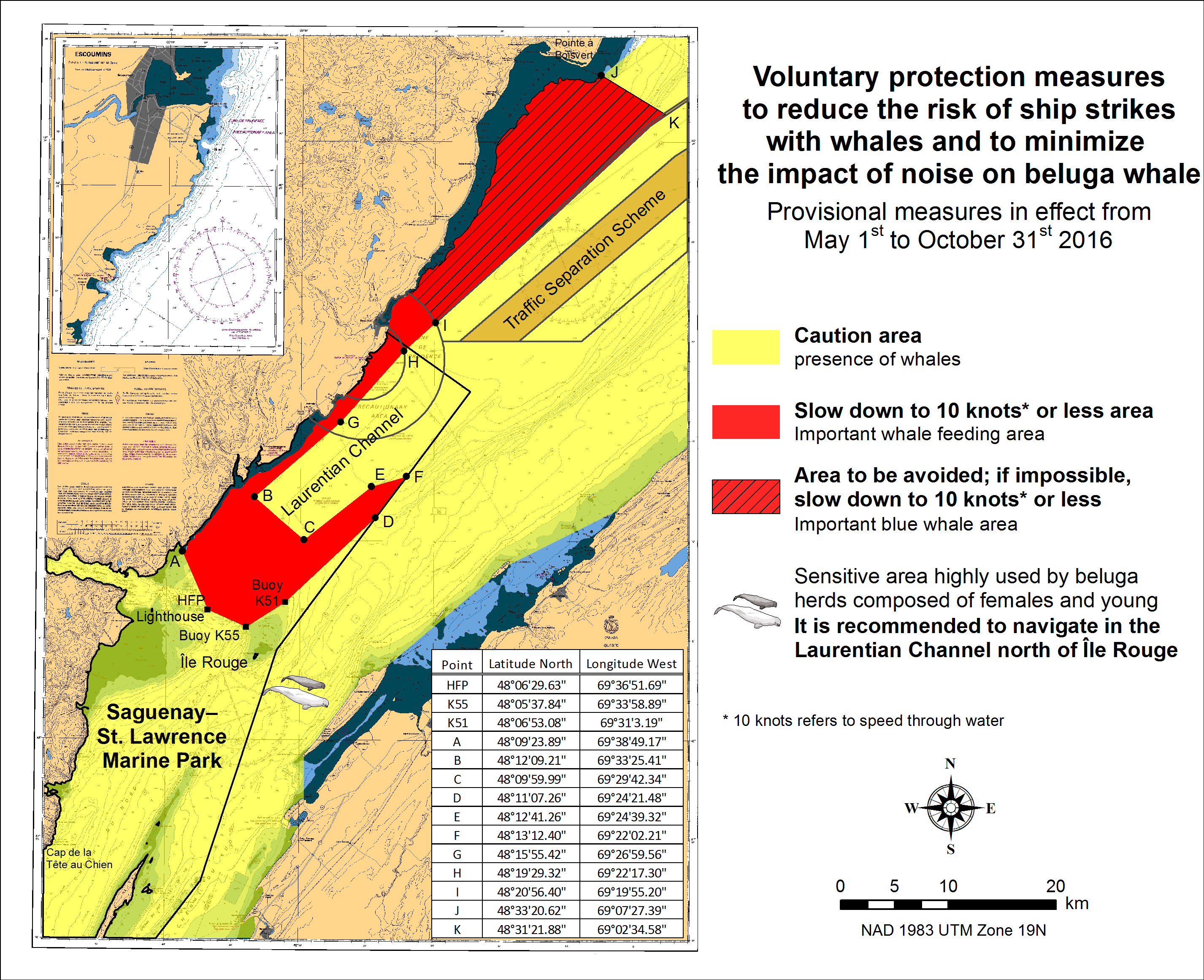
SAGUENAY-ST. LAWRENCE MARINE PARK AND SURROUNDING WATERS - WHALE PROTECTION.
The waters in and around the Saguenay-St. Lawrence Marine Park are well known for their resident threatened beluga population and the wide diversity of whales that migrate there to feed, particularly between April and November.
REGULATORY PROTECTION MEASURES
All whale species that are found in the St. Lawrence are protected under the Marine Mammal Regulations, pursuant to the Fisheries Act. Within the boundaries of the Marine Park, specific measures are set out in the Marine Activities in the Saguenay-St. Lawrence Marine Park Regulations, pursuant to the Act Establishing the Saguenay-St. Lawrence Marine Park. Any collision with a marine mammal within the Marine Park must immediately be reported to a park warden at 1-866-508-9888. For collisions that occur outside the Marine Park or for any situation involving a marine mammal that is dead or in trouble, contact the emergency network at 1-877-722-5346 or on channel 16.
For more information on the Saguenay-St. Lawrence Marine Park, see section 5C of the Annual Edition of the Notices to Mariners - April 2015 to March 2016.
VOLUNTARY PROTECTION MEASURES
Provisional measures in effect from May 1st to October 31st, 2016. See map below.
These measures apply to merchant vessels and cruise ships between Pointe à Boisvert and Cap de la Tête au Chien to prevent collisions with whales. These measures should only be taken when they will not jeopardize navigational safety.
Caution area (yellow area): To reduce the risk of collisions with whales that can be present anywhere in this area, heightened vigilance of navigators is critical. Posting a lookout is recommended in order to increase the chances of seeing the whales and thus taking necessary measures to avoid them. If bypassing the whales is not possible, slow down and wait for the animals to move away to a distance greater than 400 meters (0.215 nautical miles) before resuming original speed. It is more difficult to see the animals at night therefore increased caution is recommended.
Slow down to 10 knots or less area (red area): To reduce the risk of collisions with whales in this feeding area, it is recommended that vessels slow down to a maximum speed through the water of 10 knots and post a lookout. It is further recommended to remain in the Laurentian Channel to the north of Île Rouge to minimize the impact of noise in a sensitive area south of this island, which is highly frequented by herds of beluga whales composed of females and young.
Area to be avoided (hatched red area): To reduce noise and the risk of collisions with whales, vessels should avoid transiting through this area which is highly frequented by blue whales, an endangered species. If the area cannot be avoided, slow down to a speed through the water of 10 knots or less.
CANADIAN HYDROGRAPHIC SERVICE - ANNOUNCEMENT REGARDING TIDAL INFORMATION TABLES ON CHARTS.
*701 CANADIAN HYDROGRAPHIC SERVICE - NAUTICAL CHARTS
| CHARTS | MAIN TITLE | SCALE | PUBLISHED | CAT # | PRICE |
|---|---|---|---|---|---|
| New Charts | |||||
| 7739 | James Ross Strait | 1:80000 | 26-FEB-2016 | ||
| New Editions | |||||
| 2260 | Sarnia to/à Bayfield | 1:80000 | 15-APR-2016 | 3 | 12.00 |
| 2261 | Bayfield to/à Douglas Point | 1:80000 | 30-JUN-2016 | 3 | 12.00 |
| 3540 | Approaches to/Approches à Campbell River | 1:10000 | 01-FEB-2016 | 2 | 20.00 |
| 6100 | Lac Saint-Jean | 1:120000 | 15-APR-2016 | 1 | 28.00 |
| 6423 | Askew Islands to/à Bryan Island Kilometre 1180 / Kilometre 1240 | 1:50000 | 15-JAN-2016 | 4 | 12.00 |
| 6425 | Travaillant River to/à Adam Cabin Creek Kilometre 1325 / Kilomètre 1400 | 1:50000 | 15-JAN-2016 | 4 | 12.00 |
| 6427 | Point Separation to/au Aklavik Channel Kilometre 1480 / Kilomètre 1540 | 1:50000 | 15-JAN-2016 | 4 | 12.00 |
*702 CANADIAN HYDROGRAPHIC SERVICE - ELECTRONIC NAVIGATIONAL CHARTS
| NEW PRODUCTS | |
|---|---|
| S-57 ENC NUMBER | CHART TITLE |
| CA579157 | Carillon à/to L'Orignal |
| CA579158 | L'Orignal à/to Papineauville |
| CA579159 | Papineauville à/to Becketts Creek |
| CA579160 | Becketts Creek à/to Ottawa |
| Withdrawn products | |
| CA576342 | Botwood Harbour |
| CA576343 | Botwood Wharves |
| CA579204 | Carillon |
*703 SHIP SAFETY BULLETINS (TP 3231) – 2016
Ship Safety Bulletins address safety-related matters pertaining to vessels. Bulletins are available from
Transport Canada’s Marine Safety Directorate free of charge and are issued on an "as needed" basis. A complete
list of Ship Safety Bulletins is available on Transport Canada’s Web site at:
http://www.tc.gc.ca/eng/marinesafety/bulletins-menu.htm
If you do not have access to our Web site and wish to be included in the Ship Safety Bulletins mailing list, please send your request to the Marine Safety location provided below. We ask your cooperation in distributing copies of this listing to your colleagues, to ship owners and/or maritime companies to let them know of the existence of these Bulletins.
If this is the first time you are receiving the Bulletin, your name is probably not on Transport Canada’s mailing list. Should you wish to be included, please send your request to the Marine Safety location provided below.
How to stay up-to-date on newly published bulletins.
To receive Ship Safety Bulletins electronically, select the following Internet address and follow the instructions
on how to sign up for e-Bulletin or RSS feed services.
E-Bulletin sends a notice to your e-mail address inbox, whereas RSS feed sends a notice to your Internet
browser when a new SSB becomes available on our Internet at:
http://www.tc.gc.ca/eng/marinesafety/bulletins-menu.htm.
As of June 30, 2016, the following Ship Safety Bulletins have been issued:
| Bulletin No. | Bulletin Title | Date |
|---|---|---|
| 01/2016 | Large Fishing Vessels – Efficient Bilge Drainage Systems in all Watertight and Refrigerated Spaces | 2016-01-20 |
| 02/2016 | Streamlined Application Process for a Candidate Document Number (CDN) | 2016-04-08 |
| 03/2016 | 2016/17 Concentrated Inspection Campaign | 2016-05-05 |
| 04/2016 | Canadian Procedures for Verification of the Gross Mass of Packed Containers | 2016-05-12 |
Transport Publications (TPs) New and/or Updated – 2016
| Publication No | Title | Date |
|---|---|---|
| TP 15330 | Canadian Procedure for obtaining the verified Gross mass of packed containers as required by SOLAS VI/2 New | 2016 |
| TP 15287 | TERMPOL Review Process on the LNG Canada Project New | 2015 |
Copies of these publications may be obtained from:
Transports Canada
Marine Safety Directorate (AMSIA)
Place de Ville, Tower “C”
330 Sparks Street, 9th floor
Ottawa, Ontario, K1A 0N5
Website: Ship Safety Bulletins: :
Site web:
http://www.tc.gc.ca/eng/marinesafety/menu.htm
Publication de transports:
http://www.tc.gc.ca/eng/marinesafety/tp-menu-515.htm
Email : marinesafety-securitemaritime@tc.gc.ca
Telephone : 613-991-3135
Toll Free (Marine) : 1-866-995-9737
Teletypewrier (TTY) : 1-888-675-6863
Fax : 613-990-1879
*704 ANNUAL EDITION NOTICES TO MARINERS 1 TO 46 – NEW NOTICE 5D HAS BEEN ADDED IN SECTION A.2 PAGE 61 OF 67
GENERAL GUIDELINES FOR NATIONAL WILDLIFE AREAS.
National Wildlife Areas of Canada
National Wildlife Areas (NWAs) are protected and managed according to the
Wildlife Area Regulationsunder the Canada Wildlife Act.
The primary purpose of most NWAs is the protection and conservation of wildlife and their habitat. For this purpose,
and according to the legislation, activities that could interfere with the conservation of wildlife are prohibited in an
NWA. Consequently, a few NWAs are not accessible to the public and there are prohibited activities in all of them.
Nonetheless, the Minister of the Environment has the ability to authorize most of the activities, whether through
public notice or the issuance of permits. Those activities benefiting wildlife and their habitat, or are not inconsistent
with the purpose for which the NWA was established and are consistent with the management plan goals for the NWA may be permitted.
For general information regarding Canada’s National Wildlife Areas, please contact Environment and Climate Change
Canada at 1-800-668-6767 (in Canada only) or ec.enviroinfo.ec@canada.ca,
or visit our website: www.ec.gc.ca.
General Guidelines for National Wildlife Areas in Nunavut
Canadian and foreign ships are not allowed to enter these protected areas without a permit. Any foreign ship captain who is planning to enter in any of these protected areas without a permit, claiming a right of innocent passage, is strongly advised to communicate with Environment and Climate Change Canada (Canadian Wildlife Service) at least two weeks in advance.
In the Nunavut territory, Inuit have certain rights as per the Nunavut Land Claims Agreement (NLCA) and the Inuit Impact and Benefit Agreement (IIBA).
Akpait National Wildlife Area
Coordinates
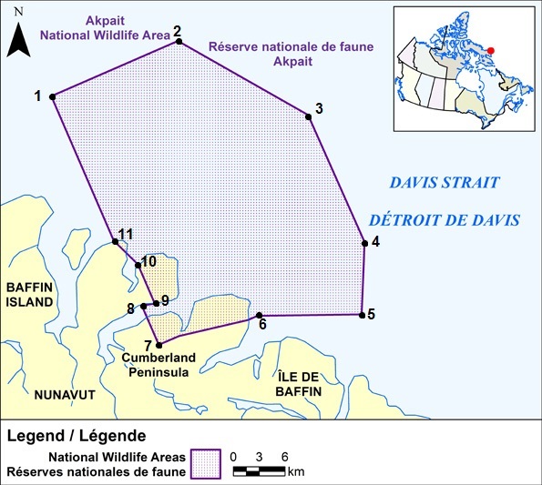
All geographic coordinates (latitude and longitude) are expressed in the North American Datum 1983 (NAD 83) geodetic reference system.
| Point | Latitude | Longitude |
|---|---|---|
| 1 | 67°08′00″ N | 61°51′00″ W |
| 2 | 67°08′00″ N | 61°29′06″ W |
| 3 | 67°00′35″ N | 61°15′00″ W |
| 4 | 66°52′00″ N | 61°15′00″ W |
| 5 | 66°48′00″ N | 61°20′00″ W |
| 6 | 66°50′30″ N | 61°35′00″ W |
| 7 | 66°51′17″ N | 61°51′00″ W |
| 8 | 66°53′55″ N | 61°51′00″ W |
| 9 | 66°53′43″ N | 61°49′00″ W |
| 10 | 66°56′21″ N | 61°49′00″ W |
| 11 | 66°58′17″ N | 61°51′00″ W |
Prohibitions
Navigating within Akpait National Wildlife Area without a permit is prohibited except for Inuit exercising their rights as per the Nunavut Land Claims Agreement or the Inuit Impact and Benefit Agreement.
Permitting Requirements
A permit must be obtained to either navigate within or conduct any type of activity in the National Wildlife Area.
Activities that may be permitted will be in accordance with the conservation objectives of the National Wildlife
Area management plan. A permit is not required for Inuit exercising their rights as per the Nunavut Land Claims
Agreement or the Inuit Impact and Benefit Agreement within the National Wildlife Area.
More information on access and permitting for Akpait National Wildlife Area can be obtained by contacting the
Environment and Climate Change Canada regional office.
Contact Information
Environment and Climate Change Canada – Prairie Northern Region
Canadian Wildlife Service
Protected Areas and Stewardship
P. O. Box 1714
Iqaluit, Nunavut,X0A 0H0
Toll Free: 1-800-668-6767 (in Canada only)
Email : ec.enviroinfo.ec@canada.ca
Ninginganiq National Wildlife Area
Coordinates

All latitudes and longitudes hereinafter are referred to the North American Datum of 1983, Canadian Spatial Reference System (NAD83(CSRS)
| Point | Latitude | Longitude |
|---|---|---|
| 1 | 69°50′00″ N | 67°13′16.87″ W |
| 2 | 69°50′00″ N | 66°36′03″ W |
| 3 | 69°17′00″ N | 66°07′13″ W |
| 4 | 69°17′00″ N | 66°44′03.04″ W |
| 5 | 69°34′43.78″ N | 68°40′00″ W |
| 6 | 69°39′27.57″ N | 68°40′00″ W |
Prohibitions
Navigating within Ninginganiq National Wildlife Area without a permit is prohibited except for Inuit exercising their rights as per the Nunavut Land Claims Agreement or the Inuit Impact and Benefit Agreement.
Permitting Requirements
A permit must be obtained to either navigate within or conduct any type of activity in the National Wildlife Area.
Activities that may be permitted will be in accordance with the conservation objectives of the National Wildlife
Area management plan. A permit is not required for Inuit exercising their rights as per the Nunavut Land Claims
Agreement or the Inuit Impact and Benefit Agreement within the National Wildlife Area.
More information on access and permitting for Ninginganiq National Wildlife Area can be obtained by contacting
the Environment and Climate Change Canada regional office.
https://ec.gc.ca/ap-pa/default.asp?lang=En&n=47D87A04-1#_005
Contact Information
Environment and Climate Change Canada – Prairie Northern Region
Canadian Wildlife Service
Protected Areas and Stewardship
P. O. Box 1714
Iqaluit, Nunavut,X0A 0H0
Toll Free: 1-800-668-6767 (in Canada only)
Email : ec.enviroinfo.ec@canada.ca
Nirjutiqavvik National Wildlife Area
Coordinates
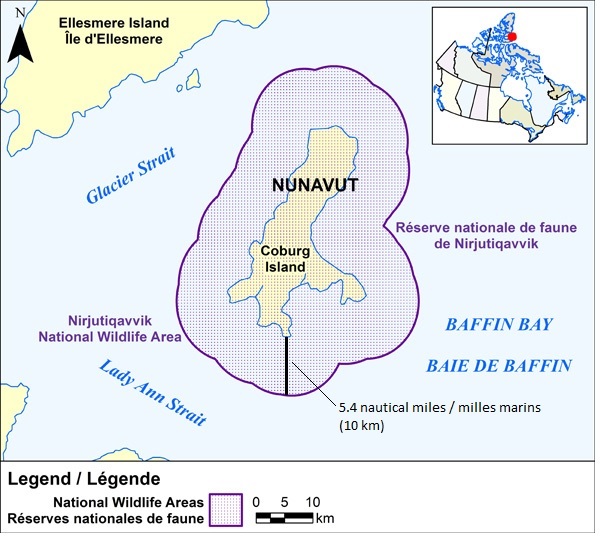
All latitudes and longitudes hereinafter described refer to the 1927 North American Datum.
All of the island known as Coburg Island, the centre of which having approximate latitude 75°57′50″ and approximate longitude 79°19′30″; and also all that land covered by water immediately adjacent to said Coburg Island and extending 10 km (5.4 Nautical Miles) from the ordinary high-water mark thereof.
Prohibitions
Navigating within Nirjutiqavvik National Wildlife Area without a permit is prohibited except for Inuit exercising their rights as per the Nunavut Land Claims Agreement or the Inuit Impact and Benefit Agreement.
Permitting Requirements
A permit must be obtained to either navigate within or conduct any type of activity in the National Wildlife Area.
Activities that may be permitted will be in accordance with the conservation objectives of the National Wildlife Area management plan.
A permit is not required for Inuit exercising their rights as per the Nunavut Land Claims Agreement or the Inuit
Impact and Benefit Agreement within the National Wildlife Area.
More information on access and permitting for Nirjutiqavvik National Wildlife Area can be obtained by contacting the
Environment and Climate Change Canada regional office.
Contact Information
Environment and Climate Change Canada – Prairie Northern Region
Canadian Wildlife Service
Protected Areas and Stewardship
P. O. Box 1714
Iqaluit, Nunavut,X0A 0H0
Toll Free: 1-800-668-6767 (in Canada only)
Email : ec.enviroinfo.ec@canada.ca
Qaqulluit National Wildlife Area
Coordinates

All latitudes and longitudes hereinafter are referred to the North American Datum of 1983, Canadian Spatial Reference System (NAD83(CSRS));
| Point | Latitude | Longitude |
|---|---|---|
| 1 | 67°17′13.53″ N | 62°47′28.04″ W |
| 2 | 67°21′05.00″ N | 62°37′07.13″ W |
| 3 | 67°21′40.56″ N | 62°22′47.50″ W |
| 4 | 67°18′24.40″ N | 62°11′09.29″ W |
| 5 | 67°13′05.16″ N | 62°07′02.76″ W |
| 6 | 67°08′01.14″ N | 62°12′15.74″ W |
| 7 | 67°10′31.73″ N | 62°21′46.00″ W |
| 8 | 67°11′35.41″ N | 62°21′58.76″ W |
| 9 | 67°12′15.21″ N | 62°23′25.39″ W |
| 10 | 67°12′38.43″ N | 62°25′04.87″ W |
| 11 | 67°11′38.90″ N | 62°26′01.70″ W |
Prohibitions
Navigating within Qaqulluit National Wildlife Area without a permit is prohibited except for Inuit exercising their rights as per the Nunavut Land Claims Agreement or the Inuit Impact and Benefit Agreement.
Permitting Requirements
A permit must be obtained to either navigate within or conduct any type of activity in the National Wildlife Area. Activities that may be permitted will be in accordance with the conservation objectives of the National Wildlife Area management plan. A permit is not required for Inuit exercising their rights as per the Nunavut Land Claims Agreement or the Inuit Impact and Benefit Agreement within the National Wildlife Area.
More information on access and permitting for Qaqulluit National Wildlife Area can be obtained by contacting the
Environment and Climate Change Canada regional office.
Contact Information
Environment and Climate Change Canada – Prairie Northern Region
Canadian Wildlife Service
Protected Areas and Stewardship
P. O. Box 1714
Iqaluit, Nunavut,X0A 0H0
Toll Free: 1-800-668-6767 (in Canada only)
Email : ec.enviroinfo.ec@canada.ca
Polar Bear Pass National Wildlife Area
Coordinates
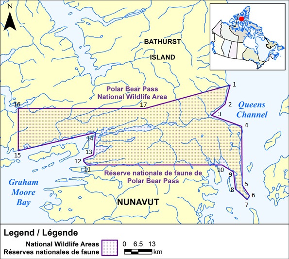
All coordinates quoted herein being Universal Transverse Mercator coordinates in Zone 14;
| Point | Northing | Easting |
|---|---|---|
| 1 | 8 421 000 | 540 000 |
| 2 | 8 412 000 | 537 600 |
| 3 | 8 406 700 | 531 300 |
| 4 | 8 401 500 | 545 500 |
| 5 | 8 373 800 | 545 700 |
| 6 | 8 368 700 | 549 200 |
| 7 | 8 367 000 | 548 000 |
| 8 | 8 372 000 | 542 500 |
| 9 | 8 380 000 | 541 600 |
| 10 | 8 383 300 | 536 200 |
| 11 | 8 383 300 | 472 600 |
| 12 | 8 384 900 | 470 900 |
| 13 | 8 386 100 | 470 800 |
| 14 | 8 388 100 | 475 600 |
| 15 | 8 398 600 | 476 400 |
| 16 | 8 390 000 | 440 000 |
| 17 | 8 410 000 | 500 000 |
Prohibitions
Navigating within Polar Bear Pass National Wildlife Area without a permit is prohibited except for Inuit exercising their rights as per the Nunavut Land Claims Agreement or the Inuit Impact and Benefit Agreement.
Permitting Requirements
A permit must be obtained to either navigate within or conduct any type of activity in the National Wildlife Area. Activities that may be permitted will be in accordance with the conservation objectives of the National Wildlife Area management plan. A permit is not required for Inuit exercising their rights as per the Nunavut Land Claims Agreement or the Inuit Impact and Benefit Agreement within the National Wildlife Area.
More information on access and permitting for Polar Bear Pass National Wildlife Area can be obtained by contacting the
Environment and Climate Change Canada regional office.
Contact Information
Environment and Climate Change Canada – Prairie Northern Region
Canadian Wildlife Service
Protected Areas and Stewardship
P. O. Box 1714
Iqaluit, Nunavut,X0A 0H0
Toll Free: 1-800-668-6767 (in Canada only)
Email : ec.enviroinfo.ec@canada.ca
*705 CANADIAN COAST GUARD - LIST OF CHARTS AND REFERENCE CHARTS (SECTION I) AFFECTED BY TEMPORARY AND PRELIMINARY NOTICES
IN EFFECT JULY 29th, 2016
(REVISED AND PROMULGATED QUARTERLY)
| 1430 | 809(P)/15 |
| 2017 | 909(T)/14 |
| 2044 | 1005(T)/15 |
| 2315 | 1006(T)/15 515(T)/16 |
| 3057 | 209(P)/16 |
| 3478 | 1013(P)/15 |
| 3490 | 1112(P)/14 |
| 3538 | 712(P)/15 |
| 3546 | 714(P)/14 |
| 3668 | 1213(P)/14 718(P)/16 |
| 3800 | 115(P)/16 |
| 4010 | 605(P)/14 1108(P)/15 |
| 4170 | 1109(P)/15 |
| 4201 | 509(P)/13 |
| 4211 | 1205(P)/15 |
| 4236 | 609(P)/15 610(P)/15 |
| 4241 | 810(P)/14 808(P)/15 |
| 4237 | 516 (P)/16 |
| 4244 | 1006(T)/14 904(P)/15 |
| 4302 | 303(T)/16 |
| 4340 | 418(P)/14 |
| 4367 | 1008(P)/15 |
| 4374 | 508(P)/15 |
| 4375 | 411(P)/15 1004(P)/15 113(P)/16 |
| 4376 | 302(P)/16 |
| 4377 | 405(P)/13 |
| 4385 | 202(P)/15 |
| 4386 | 1108(P)/13 507(P)/14 |
| 4396 | 709(P)/14 |
| 4404 | 611(P)/16 |
| 4422 | 1005(P)/14 |
| 4425 | 517(P)/16 |
| 4507 | 715(P)/16 |
| 4512 | 1007(P)/15 |
| 4597 | 1003(P)/09 |
| 4644 | 1106(T)/15 |
| 4825 | 110(T)/16 717(P)/16 |
| 4830 | 1104(T)/13 716(P)/16 |
| 4863 | 109(T)/16 |
| 4909 | 613(P)/12 810(P)/12 714(P)/16 |
| 4911 | 510(P)/15 811(P)/12 515(P)/15 |
| 4912 | 516(P)/15 |
| 4913 | 518(P)/16 519(P)/16 |
| 4920 | 520(P)/16 |
| 5051 | 1208(T)/13 |
| 6218 | 204(T)/16 |
| 6267 | 1114(P)/14 |
| 8010 | 610(T)/16 |
| US 14832 | 712(T)/14 |
| US 14884 | 715(T)/13 |
| US 14853 | 1211(T)/14 |
| US 14865 | 807(T)/15 |
*706 CANADIAN HYDROGRAPHIC SERVICE – SAILING DIRECTIONS – CEN 308 — RIDEAU CANAL AND OTTAWA RIVER, FIRST EDITION, 2003 IS NOW AVAILABLE AS A PRINT-ON-DEMAND (POD) PRODUCT.
The Sailing Directions booklet CEN 308 — Rideau Canal and Ottawa River, First Edition, 2003 is now available as Print-on-Demand (POD) product. POD booklets are updated through Notices to Mariners to the date of printing. For instance, the POD version of CEN 308 now incorporates some 202 Notices to Mariners issued since 2003, which previously had to be manually added to the book. The Canadian Hydrographic Service (CHS) is converting all of its Sailing Directions to the POD format in response to requests received through our Level of Service initiative. Contact an authorized CHS dealer to purchase a new copy.
Please note that despite the new look, the content remains the same except that the Notices to Mariners have been incorporated up to the date of printing.
*707 TORONTO HARBOUR – UNDERWATER INTAKE PIPE HAS BEEN PERMANENTLY INSTALLED
Reference Chart: 2085
Mariners are advised an underwater intake pipe has been permanently installed in the water south of Sherbourne Common (43° 38’ 6.3”N 079° 21’ 08.5”W).
A white hazard buoy with the indication ‘‘No Anchoring’’ has been installed to mark this position.
Mariners are advised to use caution in the area.
(NOTSHIP C884/11)
*708 POINTE DES MONTS AUX/TO ESCOUMINS– UNLIGHTED BUOY TO BE DISCONTINUED.
Reference Chart: 1236
The following unlighted buoy is discontinued:
Nipigon (Proue) Priv (LL 11699) (48° 36’ 27.6”N 068° 25’ 40.6”W)
(Q2016-075)
*709 POINTE DES MONTS AUX/TO ESCOUMINS– UNLIGHTED BUOY TO BE DISCONTINUED.
Reference Chart: 1236
The following unlighted buoy is discontinued:
Nipigon (Proue) Priv (LL 11699) (48° 36’ 27.6”N 068° 25’ 40.6”W)
(Q2016-077)
*710 TAYLORS HEAD TO/À SHUT-IN ISLAND– UNLIGHTED BUOY TO BE DISCONTINUED.
Reference Chart: N/A
The following unlighted buoy is discontinued:
Musquodoboit Gardier Rock spar buoy YV14 (LL 5566.07) (44° 41’ 33”N 063° 04’ 42”W)
(F2016-022)
*711 TAYLORS HEAD TO/À SHUT-IN ISLAND – UNLIGHTED BUOY TO BE DISCONTINUED.
Reference Chart: N/A
The following unlighted buoy is discontinued:
Musquodoboit (Flat Rock) buoy YV15 (LL 5566.08) (44° 41’ 41.9”N 063° 04’ 45.3”W)
Replace by Musquodoboit (Flat Rock) light buoy YV15 (LL 566.08) (44° 41’ 41.4”N 063° 04’ 45”W)
(F2016-029)
*712 TAYLORS HEAD TO/À SHUT-IN ISLAND – UNLIGHTED BUOY TO BE DISCONTINUED.
Reference Chart: N/A
The following unlighted buoy is discontinued:
Musquodoboit (Francis Nose Is) buoy YV21 (LL 5566.12) (44° 42’ 52.9”N 063° 05’ 03.1”W),
Replace by Musqodoboit (Francis Nose Is) light buoy YV21 (LL 566.12) (44° 42’ 52.9”N 063° 05’ 03.1”W).
(F2016-023)
*714(P) DÉTROIT DE NORTHUMBERLAND/NORTHUMBERLAND STRAIT (PARTIE OUEST/WESTERN PORTION) – RANGE TO BE DISCONTINUED
Reference Chart: 4909
The Canadian Coast guard proposed to permanently discontinue the following aids to navigation:
Shediac Harbour range Front (LL 1110) (46° 14’ 30.0”N 064° 31’ 48.4”W)
Rear (LL 1111) (46° 14’ 26.1”N 064° 31’ 49.9”W)
Comments on this action are solicited from mariners and other interested parties.
Comments should be directed to the following within three months from the date of this notice:
Superintendent, Aids to Navigation,
Canadian Coast Guard,
P.O. Box 5667,
St. John’s, NL, A1C 5X1
Telephone: (709) 772-2800
Email: renee.pope@dfo-mpo.gc.ca
Any objections raised must state the facts on which they are based and should include supporting information on safety, commerce and public benefit.
(G2016-100, 101)
*715(P) PLANS - NORTHEAST COAST/CÔTE NORD-EST NEWFOUNDLAND/TERRE-NEUVE – BUOY TO BE DISCONTINUED.
Reference Chart: 4507
The Canadian Coast Guard proposes to discontinue the following aid to navigation:
Wharf Rock light buoy KN4 (LL 239.251) (51° 29’ 58.7”N 055° 28’ 26.3”W).
Comments on this action are solicited from mariners and other interested parties.
Comments should be directed to the following within three months from the date of this notice:
Superintendent, Aids to Navigation,
Canadian Coast Guard,
P.O. Box 5667,
St. John’s, NL, A1C 5X1
Telephone: (709) 772-2800
Email: renee.pope@dfo-mpo.gc.ca
Any objections raised must state the facts on which they are based and should include supporting information on safety, commerce and public benefit.
(N2016-026)
*716(P) GREAT BAY DE L'EAU AND APPROACHES/ET LES APPROCHES – LIGHT AND BELL BUOY TO BE DISCONTINUED.
Reference Chart : 4830
The Canadian Coast Guard proposes to permanently discontinue the following aid to navigation:
Sagona Island N.E light and bell buoy VSN (LL 120.4) (47° 23’ 02.9”N 055° 45’ 55”W)
Comments on this action are solicited from mariners and other interested parties.
Comments should be directed to the following within three months from the date of this notice:
Superintendent, Aids to Navigation,
Canadian Coast Guard,
P.O. Box 5667,
St. John’s, NL, A1C 5X1
Telephone: (709) 772-2800
Email: renee.pope@dfo-mpo.gc.ca
Any objections raised must state the facts on which they are based and should include supporting information on safety, commerce and public benefit.
(N2016-032)
*717(P) BURGEO AND/ET RAMEA ISLANDS – LIGHT BUOY TO BE DISCONTINUED.
Reference Chart : 4825
The Canadian Coast Guard proposes to permanently discontinue the following aid to navigation:
The Douglas light buoy QV (LL 144.3) (47° 35’ 54.6”N 057° 37’ 39.9”W)
Comments on this action are solicited from mariners and other interested parties.
Comments should be directed to the following within three months from the date of this notice:
Superintendent, Aids to Navigation,
Canadian Coast Guard,
P.O. Box 5667,
St. John’s, NL, A1C 5X1
Telephone: (709) 772-2800
Email: renee.pope@dfo-mpo.gc.ca
Any objections raised must state the facts on which they are based and should include supporting information on safety, commerce and public benefit.
(N2016-035)
*719 GUYON ISLAND TO/À FLINT ISLAND – LIGHT AND BELL BUOY PERMANENTLY CHANGED.
Reference Chart: Notice 1004(P)/15 is cancelled (Chart 4375).
(G2016-081)
*720 CAPE CANSO TO/À COUNTRY ISLAND – FOG SIGNAL PERMANENTLY DISCONTINUED.
Reference Chart: Notice 1204(P)/15 is cancelled (Chart 4233).
(G2016-089)
SECTION 2 - CHART CORRECTIONS
1230 - Cap-Chat - New Edition - 19-FEB-2010 - NAD 1983
| 15-JUL-2016 | LNM/D. 13-MAY-2016 | ||
| Add |
obstruction with known depth of 2 metres 2 decimetres
(See Chart No.1, K41) |
49°06′00.0″N 066°41′17.3″W | |
| This notice affects Electronic Navigational Chart: CA579055 | |||
| DFO(6409235-01) | |||
1230 - Grande-Vallée - New Edition - 19-FEB-2010 - NAD 1983
| 15-JUL-2016 | LNM/D. 13-MAY-2016 | |||
| Amend |
vertical clearance 2 metres 2 decimetres, to read 2 metres 4 decimetres
(See Chart No.1, D22) |
49°13′32.5″N 065°07′35.2″W | ||
| This notice affects Electronic Navigational Chart: CA579213 | ||||
| DFO(6409439-04) | ||||
1230 - Les Méchins - New Edition - 19-FEB-2010 - NAD 1983
| 15-JUL-2016 | LNM/D. 13-MAY-2016 | ||
| Amend |
vertical clearance 6 metres 1 decimetre, to read 6 metres 4 decimetres
(See Chart No.1, D22) |
49°00′10.9″N 066°58′06.9″W | |
| This notice affects Electronic Navigational Chart: CA579056 | |||
| DFO(6409439-02) | |||
1230 - Mont-Louis - New Edition - 19-FEB-2010 - NAD 1983
| 15-JUL-2016 | LNM/D. 13-MAY-2016 | ||
| Amend |
vertical clearance 1 metre 7 decimetres, to read 1 metre 8 decimetres
(See Chart No.1, D22) |
49°13′43.2″N 065°44′09.9″W | |
| This notice affects Electronic Navigational Chart: CA479057 | |||
| DFO(6409439-01) | |||
| Add |
pontoons
(See Chart No.1, F16) This notice affects Electronic Navigational Chart: CA479057 |
joining 49°14′04.8″N 065°44′13.1″W
49°14′04.8″N 065°44′11.5″W and 49°14′04.0″N 065°44′10.0″W |
|
| DFO(6409439-05) | |||
1230 - Plans - Péninsule de la Gaspésie - New Edition - 19-FEB-2010 - NAD 1983
| 15-JUL-2016 | LNM/D. 13-MAY-2016 | ||
| Affix | patch | 49°10′30.0″N 066°29′38.0″W | |
| Download patch - http://www.chs-shc.gc.ca/patches/PA1230_20160413.pdf | |||
| DFO(6409415-01) | |||
1230 - Rivière-au-Renard - New Edition - 19-FEB-2010 - NAD 1983
| 15-JUL-2016 | LNM/D. 13-MAY-2016 | ||
| Amend |
vertical clearance 2 metres 7 decimetres, to read 3 metres 0 decimetre
(See Chart No.1, D22) |
48°59′51.6″N 064°23′36.7″W | |
| This notice affects Electronic Navigational Chart: CA579167 | |||
| DFO(6409439-03) | |||
2201 - Georgian Bay / Baie Georgienne - New Edition - 18-NOV-1998 - NAD 1983
| 01-JUL-2016 | LNM/D. 09-OCT-2015 | ||
| Amend |
light characteristics Fl 7s 62ft 17M to read Fl 10s 62ft 11M against light
(See Chart No.1, P16) |
45°21′36.4″N 080°24′28.8″W |
|
| This notice affects Electronic Navigational Chart: CA273097 | |||
| (D2016003) LL(906) DFO(6604213-05) | |||
2225 - Approaches to/Approches à Parry Sound - New Edition - 08-MAR-1991 - NAD 1927
| 01-JUL-2016 | LNM/D. 02-JAN-2015 | ||
| Amend |
light characteristics Fl 7s 62ft 17M to read Fl 10s 62ft 11M against light
(See Chart No.1, P16) |
45°21′36.0″N 080°24′29.0″W | |
| This notice affects Electronic Navigational Chart: CA573283 | |||
| (D2016003) LL(906) DFO(6604213-02) | |||
2242 - Giants Tomb Island to/à Franklin Island - New Chart - 07-JAN-2005 - NAD 1983
| 01-JUL-2016 | LNM/D. 20-AUG-2010 | ||
| Amend |
light characteristics Fl 7s 20m to read Fl 10s 19m against light
(See Chart No.1, P16) |
45°21′36.4″N 080°24′28.8″W | |
| This notice affects Electronic Navigational Chart: CA373311 | |||
| (D2016003) LL(906) DFO(6604213-03) | |||
2243 - Bateau Island to/à Byng Inlet - New Edition - 30-AUG-1985 - NAD 1927
| 01-JUL-2016 | LNM/D. 12-JUN-2015 | ||
| Amend |
light characteristics Fl 7s 62ft 17M to read Fl 10s 62ft 11M against light
(See Chart No.1, P16) |
45°21′36.0″N 080°24′29.0″W | |
| This notice affects Electronic Navigational Chart: CA373311 | |||
| (D2016003) LL(906) DFO(6604213-04) | |||
2273 - South Baymouth Harbour and Approaches - New Edition - 28-AUG-2015 - World Geodetic System 1984
| 22-JUL-2016 | |||
| Add |
ferry route
(See Chart No.1, M50) This notice affects Electronic Navigational Chart: CA573461 |
joining 45°33′22.3″N 082°00′51.8″W
45°33′25.2″N 082°00′36.4″W 45°33′27.6″N 082°00′32.1″W and 45°33′31.7″N 082°00′29.6″W |
|
| DFO(6604220-01) | |||
4000 - Gulf of Maine to/à Baffin Bay / Baie de Baffin - New Edition - 25-JUL-2003 - NAD 1983
| 01-JUL-2016 | LNM/D. 17-JUL-2015 | ||
| Delete | private yellow ODAS/SADO lighted spherical Fl (5)Y20s,Priv, marked AMEC (See Chart No.1, Q58 |
48°09′55.3″N 046°14′18.2″W | |
| This notice affects Electronic Navigational Chart: CA176030 | |||
| DFO(6307562-01) | |||
4001 - Gulf of Maine to Strait of Belle Isle /au Detroit de Belle Isle - New Edition - 01-DEC-1995 - NAD 1983
| 01-JUL-2016 | LNM/D. 24-JUN-2015 | ||
| Delete | private yellow ODAS/SADO lighted spherical Fl (5)Y20s,Priv, marked AMEC (See Chart No.1, Q58) |
48°09′55.3″N 046°14′18.2″W | |
| This notice affects Electronic Navigational Chart: CA176030 | |||
| DFO(6307562-01) | |||
| Delete | obstruction depth unknown (See Chart No.1, K40) |
48°00′21.8″N 046°19′14.5″W |
|
| This notice affects Electronic Navigational Chart: CA176030, CA276477 | |||
| DFO(6307562-02) | |||
4010 - Bay of Fundy / Baie de Fundy (Inner portion / partie intérieure) - New Edition - 14-FEB-2003 - NAD 1983
| 01-JUL-2016 | LNM/D. 04-MAR-2016 | ||
| Add |
private yellow ODAS/SADO lighted pillar Fl (5) Y 20s, Priv
(See Chart No.1, Q58) |
45°12′29.8″N 066°05′47.8″W | |
| This notice affects Electronic Navigational Chart: CA376011, CA576005 | |||
| (F2016019) LL(98.8) DFO(6307546-01) | |||
4013 - Halifax to/à Sydney - New Edition - 06-SEP-2002 - NAD 1983
| 29-JUL-2016 | LNM/D. 17-JUN-2016 | ||
| Delete |
legend Fog Sig against light
(See Chart No. 1 R20) |
45°11′28.8″N 061°18′39.9″W | |
| This notice affects Electronic Navigational Chart: CA276204, CA376067, CA476068 | |||
| (G2016089) LL(646) DFO(6307614-01) | |||
4026 - Havre Saint-Pierre et/and Cap des Rosiers à/to Pointe des Monts - New Edition - 23-MAY-2014 - NAD 1983
| 08-JUL-2016 | LNM/D. 05-FEB-2016 | ||
| Amend |
vertical clearance 3 metres 1 decimetre, to read 1 metre 8 decimetres
(See Chart No.1, D22) |
49°44′45.9″N 067°10′58.9″W | |
| This notice affects Electronic Navigational Chart: CA279044 | |||
| DFO(6409442-01) | |||
4116 - Approaches to/Approches à Saint John - New Edition - 31-AUG-2007 - NAD 1983
| 01-JUL-2016 | LNM/D. 05-FEB-2016 | ||
| Add |
private yellow ODAS/SADO lighted pillar Fl (5) Y 20s, Priv
(See Chart No.1, Q58) |
45°12′29.8″N 066°05′47.8″W | |
| This notice affects Electronic Navigational Chart: CA376011, CA576005 | |||
| (F2016019) LL(98.8) DFO(6307546-01) | |||
4117 - Saint John Harbour and Approaches / et les approches - New Edition - 29-MAY-2009 - NAD 1983
| 01-JUL-2016 | LNM/D. 24-JUL-2015 | ||
| Add |
private yellow ODAS/SADO lighted pillar Fl (5) Y 20s, Priv
(See Chart No.1, Q58) |
45°12′29.8″N 066°05′47.8″W | |
| This notice affects Electronic Navigational Chart: CA376011, CA576005 | |||
| (F2016019) LL(98.8) DFO(6307546-01) | |||
4170 - Glace Bay Harbour - New Chart - 28-FEB-1992 - NAD 1983
| 22-JUL-2016 | LNM/D. 10-JUN-2016 | ||
| Add | light FlR against red starboard hand spar buoy, marked KV2 (See Chart No.1, Q7) |
46°12′31.8″N 059°56′25.5″W | |
| (G2016078) LL(771.01) DFO(6307603-01) | |||
| Add | light FlG against green port hand spar buoy, marked KV5 (See Chart No.1, Q7) |
46°12′02.9″N 059°56′42.6″W | |
| (G2016079) LL(771.04) DFO(6307603-02) | |||
| Add | light FlR against red starboard hand spar buoy, marked KV6 (See Chart No.1, Q7) |
46°12′04.2″N 059°56′45.8″W | |
| (G2016080) LL(771.05) DFO(6307603-03) | |||
4233 - Cape Canso to/à Country Island - New Chart - 11-JAN-1991 - NAD 1983
| 29-JUL-2016 | LNM/D. 17-JUN-2016 | ||
| Delete |
legend Fog Sig (3) 60s against light
(See Chart No. 1 R20) |
45°11′28.8″N 061°18′39.9″W | |
| This notice affects Electronic Navigational Chart: CA276204, CA376067, CA476068 | |||
| (G2016089) LL(646) DFO(6307614-01) | |||
4233 - Tor Bay - New Chart - 11-JAN-1991 - NAD 1983
| 29-JUL-2016 | LNM/D. 17-JUN-2016 | ||
| Delete |
legend Fog Sig (3) 60s against light
(See Chart No. 1 R20) |
45°11′28.8″N 061°18′39.9″W | |
| This notice affects Electronic Navigational Chart: CA276204, CA376067, CA476068 | |||
| (G2016089) LL(646) DFO(6307614-01) | |||
4236 - Taylors Head to/à Shut-in Island - New Edition - 13-JUL-2001 - NAD 1983
| 15-JUL-2016 | LNM/D. 08-JUL-2016 | ||
| Replace | red starboard hand spar buoy, marked YV10, with red starboard hand lighted spar buoy QR, marked YV10 (See Chart No.1, Qf) |
44°41′05.4″N 063°04′41.2″W | |
| This notice affects Electronic Navigational Chart: CA376083 | |||
| (F2016028) LL(566.03) DFO(6307600-01) | |||
| Reposition | red starboard hand lighted spar buoy QR, marked YV10 (See Chart No.1, Q7) |
from 44°41′05.4″N 063°04′41.2″W to 44°41′09.6″N 063°04′45.6″W |
|
| This notice affects Electronic Navigational Chart: CA376083 | |||
| (F2016028) LL(566.03) DFO(6307600-02) | |||
| Add | light QG against green port hand spar buoy , marked YV7 (See Chart No.1, Q7) |
44°40′44.0″N 063°04′23.4″W | |
| This notice affects Electronic Navigational Chart: CA376083 | |||
| (F2016024) LL(566.02) DFO(6307600-03) | |||
| Delete | green port hand spar buoy, marked YV11 (See Chart No.1, Qg) |
44°41′23.2″N 063°04′49.6″W | |
| This notice affects Electronic Navigational Chart: CA376083 | |||
| (F2016025) DFO(6307600-04) | |||
| Delete | red starboard hand spar buoy, marked YV12 (See Chart No.1, Qf) |
44°41′19.2″N 063°04′44.1″W | |
| This notice affects Electronic Navigational Chart: CA376083 | |||
| (F2016027) DFO(6307600-05) | |||
| Delete | green port hand spar buoy, marked YV13 (See Chart No.1, Qg) |
44°41′30.0″N 063°04′44.0″W | |
| This notice affects Electronic Navigational Chart: CA376083 | |||
| (F2016026) DFO(6307600-06) | |||
| Add | Note ″Channel Buoyed/Chenal balisé″ | 44°41′37.8″N 063°05′11.7″W | |
| This notice affects Electronic Navigational Chart: CA376083 | |||
| DFO(6307600-07) | |||
| 08-JUL-2016 | LNM/D. 06-MAY-2016 | ||
| Add | red starboard hand lighted spar buoy FlR, marked HJ2/2 (See Chart No.1, Qf) |
44°41′16.4″N 063°13′52.7″W | |
| This notice affects Electronic Navigational Chart: CA376083 | |||
| (F2016021) LL(564.22) DFO(6307590-01) | |||
| Delete |
green port hand spar buoy, marked YV5
(See Chart No.1, Qg) |
44°39′52.5″N 063°04′26.5″W | |
| This notice affects Electronic Navigational Chart: CA376083 | |||
| (F2016031) DFO(6307602-01) | |||
4321 - Cape Canso to/à Liscomb Island - New Edition - 08-OCT-2004 - NAD 1983
| 29-JUL-2016 | LNM/D. 11-MAR-2016 | ||
| Delete |
legend Fog Sig (3) 60s against light
(See Chart No. 1 R20) |
45°11′28.8″N 061°18′39.9″W | |
| This notice affects Electronic Navigational Chart: CA276204, CA376067, CA476068 | |||
| (G2016089) LL(646) DFO(6307614-01) | |||
4374 - Red Point to/à Guyon Island - New Edition - 08-NOV-2002 - NAD 1983
| 22-JUL-2016 | LNM/D. 12-FEB-2016 | ||
| Amend | NH6 to read NH4 against buoy (See Chart No. 1 Q130.1) |
45°37′15.5″N 060°34′24.8″W | |
| This notice affects Electronic Navigational Chart: CA376295 | |||
| (G2016084) LL(741.03) DFO(6307609-01) | |||
| Amend | NH8 to read NH6 against buoy (See Chart No. 1 Q130.1) |
45°37′17.5″N 060°34′30.8″W | |
| This notice affects Electronic Navigational Chart: CA376295 | |||
| (G2016085) DFO(6307609-02) | |||
| Add |
red and white fairway lighted spar buoy Mo(A), marked NH
(See Chart No.1, Qh) |
45°36′57.1″N 060°34′01.0″W | |
| This notice affects Electronic Navigational Chart: CA376295 | |||
| (G2016086) LL(741) DFO(6307609-03) | |||
| Add |
red starboard hand lighted spar buoy QR, marked NH8
(See Chart No.1, Qf) |
45°37′21.9″N 060°34′36.8″W | |
| This notice affects Electronic Navigational Chart: CA376295 | |||
| (Q2016087) LL(741.04) DFO(6307609-04) | |||
| Add |
green port hand spar buoy, marked NH7
(See Chart No.1, Qg) |
45°37′19.0″N 060°34′35.9″W | |
| This notice affects Electronic Navigational Chart: CA376295 | |||
| (G2016088) DFO(6307609-05) | |||
4375 - Guyon Island to/à Flint Island - New Edition - 11-OCT-2002 - NAD 1983
| 22-JUL-2016 | LNM/D. 17-JUN-2016 | ||
| Replace |
red starboard hand lighted pillar bell buoy FlR, BELL, marked JA2 with red starboard hand lighted spar buoy FlR, marked JA2 (See Chart No.1, Qf) |
46°09′42.3″N 059°48′46.7″W | |
| This notice affects Electronic Navigational Chart: CA376303 | |||
| (G2016081) LL(769) DFO(6307606-01) | |||
4425 - Tracadie Bay - New Edition - 01-NOV-2002 - NAD 1983
| 22-JUL-2016 | LNM/D. 04-DEC-2015 | ||
| Add |
red starboard hand lighted conical buoy FlR, marked JH2
(See Chart No.1, Qf) |
46°25′09.6″N 063°01′01.8″W | |
| (G2016054) LL(1049.121) DFO(6307563-01) | |||
| Add |
green port hand lighted can buoy FlG, marked JH1
(See Chart No.1, Qg) |
46°25′10.2″N 063°00′58.2″W | |
| (G2016071) LL(1049.11) DFO(6307563-02) | |||
| Add | Channel Buoyed/Chenal balisé | 46°24′02.4″N 063°01′03.0″W | |
| DFO(6307563-03) | |||
4468 - Île du Petit Mécatina aux/to Îles Sainte-Marie - New Edition - 27-FEB-2015 - NAD 1983
| 08-JUL-2016 | LNM/D. 03-JUN-2016 | ||
| Add |
depth of 1 metre 2 decimetres
(See Chart No.1, I10) |
50°28′48.5″N 059°32′31.9″W | |
| This notice affects Electronic Navigational Chart: CA379115 | |||
| DFO(6409457-01) | |||
4469 - Île Plate à/to Île du Petit Mécatina - New Edition - 08-NOV-1985 - NAD 1927
| 08-JUL-2016 | LNM/D. 12-FEB-2016 | |||
| Add |
Note
AVERTISSEMENT En raison de distorsions importantes sur cette carte, la ligne de rivage et les autres entités cartographiques peuvent être décalées de plus de 150 mètres par rapport à leurs vraies positions. Les navigateurs sont priés d′être très prudents. WARNING Due to significant distortions on the chart, shoreline and other chart features can be offset by more than 150 metres from their true positions. Mariners are requested to be very cautious. |
50°47′17.0″N 059°14′04.0″W | ||
| MPO(6409458-01) | ||||
| Add |
depth of 1 fathom 5 feet
(See Chart No.1, I10) |
50°44′18.5″N 059°10′13.5″W | ||
| DFO(6409458-02) | ||||
| Add |
drying height of 1 fathom 0 feet
(See Chart No.1, I15) |
50°45′01.0″N 059°00′45.8″W | ||
| DFO(6409458-03) | ||||
| Delete |
depth of 4 fathoms 2 feet
(See Chart No.1, I10) |
50°47′06.7″N 058°57′35.5″W | ||
| DFO(6409458-04) | ||||
| Delete |
depth of 11 fathoms 0 feet
(See Chart No.1, I10) |
50°47′09.7″N 058°57′44.3″W | ||
| DFO(6409458-05) | ||||
| Add |
depth of 2 fathoms 3 feet
(See Chart No.1, I10) |
50°47′07.5″N 058°57′40.3″W | ||
| DFO(6409458-06) | ||||
| Add |
depth of 4 fathoms 3 feet
(See Chart No.1, I10) |
50°43′00.1″N 058°57′42.5″W | ||
| DFO(6409458-07) | ||||
| Add |
depth of 6 fathoms 1 foot
(See Chart No.1, I10) |
50°47′35.4″N 058°57′44.9″W | ||
| DFO(6409458-08) | ||||
4472 - Baie des Homards à/to Île de la Grande Passe - New Edition - 14-AUG-1981 - NAD 1927
| 08-JUL-2016 | LNM/D. 08-APR-2016 | ||
| Delete |
depth of 2 fathoms 5 feet
(See Chart No.1, I10) |
51°07′40.6″N 058°25′57.7″W |
|
| DFO(6409459-01) | |||
| Add |
depth of 0 fathoms 5 feet
(See Chart No.1, I10) |
51°07′41.8″N 058°26′01.4″W | |
| DFO(6409459-02) | |||
| Add |
depth of 1 fathom 0 feet
(See Chart No.1, I10) |
51°08′27.2″N 058°24′44.7″W | |
| DFO(6409459-03) | |||
| Add |
depth of 1 fathom 0 feet
(See Chart No.1, I10) |
51°09′34.4″N 058°22′32.5″W | |
| DFO(6409459-04) | |||
| Add |
depth of 1 fathom 3 feet
(See Chart No.1, I10) |
51°18′19.1″N 058°15′42.5″W | |
| DFO(6409459-05) | |||
| Add |
depth of 2 fathoms 0 feet
(See Chart No.1, I10) |
51°11′55.1″N 058°19′33.9″W | |
| DFO(6409459-06) | |||
| Add |
depth of 2 fathoms 2 feet
(See Chart No.1, I10) |
51°08′13.8″N 058°24′54.7″W | |
| DFO(6409459-07) | |||
| Add |
depth of 2 fathoms 5 feet
(See Chart No.1, I10) |
51°08′46.2″N 058°23′30.3″W | |
| DFO(6409459-08) | |||
| Add |
depth of 3 fathoms 2 feet
(See Chart No.1, I10) |
51°09′09.0″N 058°23′15.6″W | |
| DFO(6409459-09) | |||
| Add |
depth of 3 fathoms 2 feet
(See Chart No.1, I10) |
51°11′48.3″N 058°17′52.0″W | |
| DFO(6409459-10) | |||
| Add |
depth of 3 fathoms 2 feet
(See Chart No.1, I10) |
51°12′26.6″N 058°17′51.8″W | |
| DFO(6409459-11) | |||
| Add |
depth of 3 fathoms 3 feet
(See Chart No.1, I10) |
51°11′31.7″N 058°17′27.3″W | |
| DFO(6409459-12) | |||
| Delete |
depth of 14 fathoms 0 feet
(See Chart No.1, I10) |
51°11′06.3″N 058°17′51.3″W | |
| DFO(6409459-13) | |||
| Add |
depth of 3 fathoms 4 feet
(See Chart No.1, I10) |
51°11′08.8″N 058°17′50.1″W | |
| DFO(6409459-14) | |||
| Add |
depth of 3 fathoms 4 feet
(See Chart No.1, I10) |
51°08′58.0″N 058°23′13.0″W | |
| DFO(6409459-15) | |||
| Add |
depth of 3 fathoms 5 feet
(See Chart No.1, I10) |
51°12′46.7″N 058°16′38.8″W | |
| DFO(6409459-16) | |||
| Add |
depth of 4 fathoms 2 feet
(See Chart No.1, I10) |
51°10′58.1″N 058°19′08.2″W | |
| DFO(6409459-17) | |||
4473 - Île de la Grande Passe aux/to Îles Bun - New Edition - 28-OCT-2005 - NAD 1983
| 08-JUL-2016 | LNM/D. 08-APR-2016 | ||
| Add |
depth of 1 metre 6 decimetres
(See Chart No.1, I10) |
50°59′18.2″N 058°41′23.3″W | |
| DFO(6409467-01) | |||
| Add |
depth of 1 metre 7 decimetres
(See Chart No.1, I10) |
50°58′11.6″N 058°44′47.2″W | |
| DFO(6409467-02) | |||
| Add |
depth of 2 metres 9 decimetres
(See Chart No.1, I10) |
51°01′21.1″N 058°44′50.3″W | |
| DFO(6409467-03) | |||
| Delete |
depth of 6 metres 4 decimetres
(See Chart No.1, I10) |
51°04′52.2″N 058°40′15.3″W | |
| DFO(6409467-04) | |||
| Delete |
depth of 15 metres 9 decimetres
(See Chart No.1, I10) |
51°04′53.4″N 058°40′19.5″W | |
| DFO(6409467-05) | |||
| Add |
depth of 3 metres 0 decimetre
(See Chart No.1, I10) |
51°04′52.9″N 058°40′17.3″W | |
| DFO(6409467-06) | |||
| Delete |
depth of 8 metres 8 decimetres
(See Chart No.1, I10) |
51°04′21.4″N 058°42′04.4″W | |
| DFO(6409467-07) | |||
| Add |
depth of 4 metres 5 decimetres
(See Chart No.1, I10) |
51°04′20.4″N 058°42′08.2″W | |
| DFO(6409467-08) | |||
| Delete |
depth of 10 metres 1 decimetre
(See Chart No.1, I10) |
50°58′24.8″N 058°45′38.2″W | |
| DFO(6409467-09) | |||
| Add |
depth of 5 metres 5 decimetres
(See Chart No.1, I10) |
50°58′23.5″N 058°45′35.2″W | |
| DFO(6409467-10) | |||
| Add |
depth of 8 metres 0 decimetre
(See Chart No.1, I10) |
50°58′42.8″N 058°43′26.4″W | |
| DFO(6409467-11) | |||
| Add |
depth of 1 metre 6 decimetres
(See Chart No.1, I10) |
51°07′42.3″N 058°26′11.7″W | |
| DFO(6409467-12) | |||
| Delete |
depth of 5 metres 2 decimetres
(See Chart No.1, I10) |
51°07′41.1″N 058°25′53.7″W | |
| DFO(6409467-13) | |||
| Delete |
depth of 14 metres 3 decimetres
(See Chart No.1, I10) |
51°07′44.3″N 058°26′00.5″W | |
| DFO(6409467-14) | |||
| Add |
depth of 1 metre 6 decimetres
(See Chart No.1, I10) |
51°07′42.0″N 058°25′58.1″W | |
| DFO(6409467-15) | |||
| Delete |
depth of 9 metres 4 decimetres
(See Chart No.1, I10) |
51°08′29.4″N 058°24′39.6″W | |
| DFO(6409467-16) | |||
| Add |
depth of 1 metre 9 decimetres
(See Chart No.1, I10) |
51°08′27.4″N 058°24′41.4″W | |
| DFO(6409467-17) | |||
| Add |
depth of 2 metres 6 decimetres
(See Chart No.1, I10) |
51°07′56.6″N 058°27′05.5″W | |
| DFO(6409467-18) | |||
| Add |
depth of 3 metres 1 decimetre
(See Chart No.1, I10) |
51°08′07.8″N 058°27′35.3″W | |
| DFO(6409467-19) | |||
| Add |
depth of 3 metres 2 decimetres
(See Chart No.1, I10) |
51°06′49.3″N 058°36′43.7″W | |
| DFO(6409467-20) | |||
| Add |
depth of 3 metres 9 decimetres
(See Chart No.1, I10) |
51°05′45.6″N 058°35′06.4″W | |
| DFO(6409467-21) | |||
| Add |
depth of 4 metres 0 decimetres
(See Chart No.1, I10) |
51°04′00.3″N 058°37′01.3″W | |
| DFO(6409467-22) | |||
| Delete |
depth of 15 metres 2 decimetres
(See Chart No.1, I10) |
51°06′54.4″N 058°27′17.1″W | |
| DFO(6409467-23) | |||
| Add |
depth of 4 metres 0 decimetre
(See Chart No.1, I10) |
51°06′52.8″N 058°27′15.8″W | |
| DFO(6409467-24) | |||
| Add |
depth of 4 metres 2 decimetres
(See Chart No.1, I10) |
51°08′14.0″N 058°24′51.5″W | |
| DFO(6409467-25) | |||
| Add |
depth of 5 metres 5 decimetres
(See Chart No.1, I10) |
51°03′14.0″N 058°37′29.1″W | |
| DFO(6409467-26) | |||
| Add |
depth of 5 metres 7 decimetres
(See Chart No.1, I10) |
51°07′07.1″N 058°29′23.3″W | |
| DFO(6409467-27) | |||
| Delete |
depth of 13 metres 7 decimetres
(See Chart No.1, I10) |
51°06′27.0″N 058°29′29.5″W | |
| DFO(6409467-28) | |||
| Add |
depth of 5 metres 8 decimetres
(See Chart No.1, I10) |
51°06′27.0″N 058°29′25.9″W | |
| DFO(6409467-29) | |||
| Add |
depth of 7 metres 2 decimetres
(See Chart No.1, I10) |
51°05′59.1″N 058°31′00.0″W | |
| DFO(6409467-30) | |||
4474 - Îles Bun à/to Baie des Moutons - New Edition - 28-MAY-1999 - NAD 1983
| 08-JUL-2016 | LNM/D. 08-APR-2016 | ||
| Add |
drying height of 1 fathom 0 feet
(See Chart No.1, I15) |
50°45′01.2″N 059°00′42.7″W | |
| DFO(6409466-01) | |||
| Add |
drying height of 0 fathoms 2 feet
(See Chart No.1, I15) |
50°44′30.5″N 059°03′07.0″W | |
| DFO(6409466-02) | |||
| Add |
depth of 0 fathoms 5 feet
(See Chart No.1, I10) |
50°54′07.0″N 058°48′01.0″W | |
| DFO(6409466-03) | |||
| Add |
depth of 0 fathoms 5 feet
(See Chart No.1, I10) |
50°54′28.7″N 058°48′47.7″W | |
| DFO(6409466-04) | |||
| Add |
depth of 1 fathom 0 feet
(See Chart No.1, I10) |
50°57′55.9″N 058°48′13.2″W | |
| DFO(6409466-05) | |||
| Add |
depth of 1 fathom 0 feet
(See Chart No.1, I10) |
50°58′11.6″N 058°44′47.2″W | |
| DFO(6409466-06) | |||
| Delete |
depth of 2 fathoms 2 feet
(See Chart No.1, I10) |
50°57′27.3″N 058°47′01.9″W | |
| DFO(6409466-07) | |||
| Add |
depth of 1 fathom 2 feet
(See Chart No.1, I10) |
50°57′25.5″N 058°47′02.5″W | |
| DFO(6409466-08) | |||
| Delete |
depth of 2 fathoms 1 foot
(See Chart No.1, I10) |
50°54′30.2″N 058°48′55.1″W | |
| DFO(6409466-09) | |||
| Add |
depth of 1 fathom 2 feet
(See Chart No.1, I10) |
50°54′29.8″N 058°48′54.6″W | |
| DFO(6409466-10) | |||
| Delete |
depth of 2 fathoms 2 feet
(See Chart No.1, I10) |
50°57′22.0″N 058°45′56.2″W | |
| DFO(6409466-11) | |||
| Add |
depth of 1 fathom 3 feet
(See Chart No.1, I10) |
50°57′20.8″N 058°45′56.7″W | |
| DFO(6409466-12) | |||
| Add |
depth of 1 fathom 4 feet
(See Chart No.1, I10) |
51°01′21.1″N 058°44′50.3″W | |
| DFO(6409466-13) | |||
| Delete |
depth of 3 fathoms 4 feet
(See Chart No.1, I10) |
50°56′24.0″N 058°47′50.3″W | |
| DFO(6409466-14) | |||
| Add |
depth of 2 fathoms 0 feet
(See Chart No.1, I10) |
50°56′23.9″N 058°47′53.4″W | |
| DFO(6409466-15) | |||
| Delete |
depth of 4 fathoms 3 feet
(See Chart No.1, I10) |
50°56′21.2″N 058°50′40.3″W | |
| DFO(6409466-16) | |||
| Add |
depth of 2 fathoms 2 feet
(See Chart No.1, I10) |
50°56′22.3″N 058°50′36.8″W | |
| DFO(6409466-17) | |||
| Add |
depth of 2 fathoms 3 feet
(See Chart No.1, I10) |
50°47′07.7″N 058°57′37.2″W | |
| DFO(6409466-18) | |||
| Add |
depth of 2 fathoms 3 feet
(See Chart No.1, I10) |
50°57′57.3″N 058°53′01.2″W | |
| DFO(6409466-19) | |||
| Add |
depth of 2 fathoms 4 feet
(See Chart No.1, I10) |
50°56′33.7″N 058°49′33.1″W | |
| DFO(6409466-20) | |||
| Add |
depth of 2 fathoms 4 feet
(See Chart No.1, I10) |
50°57′45.7″N 058°50′04.1″W | |
| DFO(6409466-21) | |||
| Delete |
depth of 11 fathoms 0 feet
(See Chart No.1, I10) |
50°58′07.0″N 058°49′57.1″W | |
| DFO(6409466-22) | |||
| Add |
depth of 2 fathoms 5 feet
(See Chart No.1, I10) |
50°58′07.3″N 058°49′57.8″W | |
| DFO(6409466-23) | |||
| Delete |
depth of 5 fathoms 3 feet
(See Chart No.1, I10) |
50°58′24.4″N 058°45′37.9″W | |
| DFO(6409466-24) | |||
| Add |
depth of 3 fathoms 0 feet
(See Chart No.1, I10) |
50°58′23.5″N 058°45′35.2″W | |
| DFO(6409466-25) | |||
| Delete |
depth of 6 fathoms 1 foot
(See Chart No.1, I10) |
50°55′16.4″N 058°52′54.4″W | |
| DFO(6409466-26) | |||
| Add |
depth of 3 fathoms 2 feet
(See Chart No.1, I10) |
50°55′17.5″N 058°52′53.8″W | |
| DFO(6409466-27) | |||
| Add |
depth of 3 fathoms 3 feet
(See Chart No.1, I10) |
51°02′41.4″N 058°48′48.9″W | |
| DFO(6409466-28) | |||
| Delete |
depth of 6 fathoms 1 foot
(See Chart No.1, I10) |
50°59′13.0″N 058°49′07.6″W | |
| DFO(6409466-29) | |||
| Add |
depth of 3 fathoms 4 feet
(See Chart No.1, I10) |
50°59′14.1″N 058°49′09.3″W | |
| DFO(6409466-30) | |||
| Add |
depth of 3 fathoms 4 feet
(See Chart No.1, I10) |
50°57′35.4″N 058°44′32.4″W | |
| DFO(6409466-31) | |||
| Add |
depth of 3 fathoms 5 feet
(See Chart No.1, I10) |
50°58′19.9″N 058°55′39.0″W | |
| DFO(6409466-32) | |||
| Add |
depth of 4 fathoms 2 feet
(See Chart No.1, I10) |
50°58′42.8″N 058°43′26.4″W | |
| DFO(6409466-33) | |||
| Delete |
depth of 6 fathoms 4 feet
(See Chart No.1, I10) |
50°55′52.0″N 058°53′38.6″W | |
| DFO(6409466-34) | |||
| Add |
depth of 4 fathoms 3 feet
(See Chart No.1, I10) |
50°55′51.6″N 058°53′39.6″W | |
| DFO(6409466-35) | |||
| Add |
depth of 4 fathoms 4 feet
(See Chart No.1, I10) |
50°57′43.4″N 058°46′17.0″W | |
| DFO(6409466-36) | |||
| Delete |
depth of 6 fathoms 2 feet
(See Chart No.1, I10) |
50°55′00.4″N 058°51′04.3″W | |
| DFO(6409466-37) | |||
| Add |
depth of 4 fathoms 4 feet
(See Chart No.1, I10) |
50°55′00.8″N 058°51′06.6″W | |
| DFO(6409466-38) | |||
| Add |
depth of 4 fathoms 4 feet
(See Chart No.1, I10) |
50°57′56.0″N 058°56′16.7″W | |
| DFO(6409466-39) | |||
| Add |
depth of 5 fathoms 0 feet
(See Chart No.1, I10) |
50°54′26.1″N 058°49′31.4″W | |
| DFO(6409466-40) | |||
| Delete |
depth of 6 fathoms 3 feet
(See Chart No.1, I10) |
50°55′49.8″N 058°50′32.3″W | |
| DFO(6409466-41) | |||
| Add |
depth of 5 fathoms 1 foot
(See Chart No.1, I10) |
50°55′50.3″N 058°50′29.9″W | |
| DFO(6409466-42) | |||
| Delete |
depth of 15 fathoms 0 feet
(See Chart No.1, I10) |
50°53′54.1″N 058°51′59.2″W | |
| DFO(6409466-43) | |||
| Add |
depth of 5 fathoms 3 feet
(See Chart No.1, I10) |
50°53′55.0″N 058°51′56.8″W | |
| DFO(6409466-44) | |||
| Add |
depth of 5 fathoms 4 feet
(See Chart No.1, I10) |
50°58′41.5″N 058°51′14.2″W | |
| DFO(6409466-45) | |||
| Add |
depth of 5 fathoms 4 feet
(See Chart No.1, I10) |
50°55′43.6″N 058°50′04.5″W | |
| DFO(6409466-46) | |||
| Add |
depth of 6 fathoms 1 foot
(See Chart No.1, I10) |
50°47′35.6″N 058°57′41.8″W | |
| DFO(6409466-47) | |||
| Add |
depth of 6 fathoms 2 feet
(See Chart No.1, I10) |
50°53′51.0″N 058°51′18.4″W | |
| DFO(6409466-48) | |||
4851 - Trinity Bay - Southern Portion/Partie Sud - New Edition - 04-APR-1997 - NAD 1983
| 08-JUL-2016 | LNM/D. 20-NOV-2015 | ||
| Reposition | Red Starboard lighted Spar buoy, marked TN2 |
from 47°35′55.0″N 053°33′30.0″W
to 47°35′39.0″N 053°33′17.4″W |
|
| (N2016014) LL(466.91) DFO(6307561-01) | |||
4956 - Cap-aux-Meules - New Edition - 02-SEP-2011 - NAD 1983
| 08-JUL-2016 | LNM/D. 17-JUN-2016 | ||
| Add |
depth of 1 metre 7 decimetres
(See Chart No.1, I10) |
47°22′36.3″N 061°51′25.4″W | |
| This notice affects Electronic Navigational Chart: CA579046 | |||
| DFO(6409465-01) | |||
5048 - Cape Harrigan to/aux Kitlit Islands - New Edition - 25-DEC-2015 - NAD 1983
| 15-JUL-2016 | LNM/D. 01-JUL-2016 | ||
| Amend | ′Route Usually Followed/Route normalement naviguée′ to read ′Alternate Route / Route alternative′ | 56°05′30.0″N 060°46′18.0″W | |
| DFO(6307640-01) | |||
| 01-JUL-2016 | |||
| Amend | ′Alternate Route / Route alternative′ to read ′Route Usually Followed/Route normalement naviguée′ | 56°05′51.0″N 060°44′31.2″W | |
| This notice affects Electronic Navigational Chart: CA376049 | |||
| DFO(6307551-02) | |||
| Amend | ′Route Usually Followed / Route normalement naviguée′ to read ′Alternate Route/Route alternative′ | 56°04′33.3″N 060°50′04.2″W | |
| This notice affects Electronic Navigational Chart: CA376049 | |||
| DFO(6307551-06) | |||
5049 - Davis Inlet to/aux Seniarlit Islands - New Edition - 25-JUN-1999 - NAD 1983
| 01-JUL-2016 | LNM/D. 09-AUG-2013 | ||
| Amend | ′Alternate Route / Route alternative′ to read ′Route Usually Followed/Route normalement naviguée′ | 56°10′41.4″N 060°51′51.4″W | |
| This notice affects Electronic Navigational Chart: CA376049 | |||
| DFO(6307551-01) | |||
| Amend | ′Alternate Route / Route alternative′ to read ′Route Usually Followed/Route normalement naviguée′ | 56°06′23.8″N 060°52′04.4″W | |
| This notice affects Electronic Navigational Chart: CA376049, CA476485 | |||
| DFO(6307551-05) | |||
| Amend | ′Route Usually Followed / Route normalement naviguée′ to read ′Alternate Route/Route alternative′ | 56°04′29.3″N 060°50′20.5″W | |
| This notice affects Electronic Navigational Chart: CA376049 | |||
| DFO(6307551-06) | |||
5049 - South of / Sud de Drawbucket Tickle - New Edition - 25-JUN-1999 - NAD 1983
| 01-JUL-2016 | LNM/D. 09-AUG-2013 | ||
| Amend | ′Route Usually Followed′ to read ′Alternate Route′ | 56°07′39.5″N 060°49′33.3″W | |
| This notice affects Electronic Navigational Chart: CA476485 | |||
| DFO(6307551-03) | |||
| Amend | ′Route normalement naviguée′ to read ′Route alternative′ | 56°06′02.2″N 060°47′33.9″W | |
| This notice affects Electronic Navigational Chart: CA376049, CA476485 | |||
| DFO(6307551-04) | |||
| Amend | ′Alternate Route / Route alternative′ to read ′Route Usually Followed/Route normalement naviguée′ | 56°06′23.8″N 060°52′01.0″W | |
| This notice affects Electronic Navigational Chart: CA376049, CA476485 | |||
| DFO(6307551-05) | |||
5051 - Nunaksuk Island to/à Calf, Cow and/et Bull Islands - New Edition - 25-APR-2014 - NAD 1983
| 01-JUL-2016 | |||
| Amend | ′Alternate Route / Route alternative′ to read ′Route Usually Followed/Route normalement naviguée′ | 56°08′21.8″N 060°47′26.3″W | |
| This notice affects Electronic Navigational Chart: CA376049 | |||
| DFO(6307551-01) | |||
| Amend |
′Route Usually Followed/Route normalement naviguée′
to read ′Alternate Route / Route alternative′ |
56°05′31.2″N 060°46′12.3″W | |
| This notice affects Electronic Navigational Chart: CA376049, CA476485 | |||
| DFO(6307551-04) | |||
| Amend | ′Alternate Route / Route alternative′ to read ′Route Usually Followed/Route normalement naviguée′ | 56°06′26.7″N 060°52′03.9″W | |
| This notice affects Electronic Navigational Chart: CA376049, CA476485 | |||
| DFO(6307551-05) | |||
| Amend |
′Route Usually Followed / Route normalement naviguée′
to read ′Alternate Route/Route alternative′ |
56°04′28.4″N 060°50′32.4″W | |
| This notice affects Electronic Navigational Chart: CA376049 | |||
| DFO(6307551-06) | |||
6251 - Red River / Rivière Rouge to/à Gull Harbour - Sheet/Feuille 1 - New Edition - 26-MAY-2000 - NAD 1927
| 29-JUL-2016 | LNM/D. 31-AUG-2007 | ||
| Add |
obstruction depth unknown Rep (2016)
(See Chart No.1, K40) |
50°28′30.4″N 096°35′03.2″W | |
| DFO(6604223-01) | |||
7750 - Cambridge Bay - New Edition - 19-JAN-2007 - NAD 1983
| 08-JUL-2016 | LNM/D. 03-OCT-2014 | ||
| Delete | crib with depth of 6.1 metres | 69°06′48.1″N 105°03′38.1″W | |
| This notice affects Electronic Navigational Chart: CA473332, CA573333 | |||
| DFO(6604215-01) | |||
7750 - Cambridge Bay Harbour - New Edition - 19-JAN-2007 - NAD 1983
| 08-JUL-2016 | LNM/D. 03-OCT-2014 | ||
| Delete | crib with depth of 6.1 metres | 69°06′48.1″N 105°03′38.1″W | |
| This notice affects Electronic Navigational Chart: CA473332, CA573333 | |||
| DFO(6604215-01) | |||
| Delete |
submarine power cable
(See Chart No.1, L31.1) |
joining 69°06′50.1″N 105°03′36.6″W
69°06′49.5″N 105°03′38.8″W and 69°06′48.1″N 105°03′38.1″W |
|
| This notice affects Electronic Navigational Chart: CA573333 | |||
| DFO(6604215-02) | |||
| Add |
crib with depth of 11.5 metres
(See Chart No.1, Fb,Ka) |
69°06′45.7″N 105°03′53.6″W | |
| This notice affects Electronic Navigational Chart: CA573333 | |||
| DFO(6604215-04) | |||
| Add |
submarine power cable
(See Chart No.1, L31.1) |
joining 69°06′50.1″N 105°03′36.6″W
69°06′47.0″N 105°03′51.0″W and 69°06′45.7″N 105°03′53.6″W |
|
| This notice affects Electronic Navigational Chart: CA573333 | |||
| DFO(6604215-05) | |||
8012 - Flemish Pass/Passe Flamande - New Edition - 11-OCT-2002 - NAD 1983
| 01-JUL-2016 | LNM/D. 24-JUN-2016 | ||
| Delete |
private yellow ODAS/SADO lighted spherical Fl(5)Y 20s, Priv, marked AMEC
(See Chart No.1, Q58) |
48°09′55.3″N 046°14′18.2″W | |
| This notice affects Electronic Navigational Chart: CA176030 | |||
| DFO(6307562-01) | |||
| Delete |
obstruction depth unknown
(See Chart No.1, K40) |
48°00′21.8″N 046°19′14.5″W | |
| This notice affects Electronic Navigational Chart: CA176030, CA276477 | |||
| DFO(6307562-02) | |||
8013 - Flemish Cap/Bonnet Flamand - New Edition - 06-FEB-2004 - NAD 1983
| 01-JUL-2016 | LNM/D. 04-DEC-2015 | ||
| Delete |
private yellow ODAS/SADO lighted spherical Fl(5)Y 20s, Priv, marked AMEC
(See Chart No.1, Q58) |
48°09′55.3″N 046°14′18.2″W | |
| This notice affects Electronic Navigational Chart: CA176030 | |||
| DFO(6307562-01) | |||
| Delete |
obstruction depth unknown
(See Chart No.1, K40) |
48°00′21.8″N 046°19′14.5″W | |
| This notice affects Electronic Navigational Chart: CA176030, CA276477 | |||
| DFO(6307562-02) | |||
SECTION 3 - RADIO AIDS TO MARINE NAVIGATION CORRECTIONS
SECTION 4 - SAILING DIRECTIONS AND SMALL CRAFT GUIDE CORRECTIONS
ATL 100 — General Information, Atlantic Coast, Second Edition, 2007 —
Chapter 3 — Delete paragraph 185.2
Replace by: 185.2 Information is available for sites at Holyrood, St. John’s, Placentia Bay, Port aux Basques,
Bay of Islands and Bay of Exploits, Newfoundland and Labrador, Saint John, New Brunswick and Halifax, Nova Scotia.
In addition to site specific observations, Placentia Bay, Saint John and Halifax Harbour also provide marine forecasting.
(A2016-000.1)
ATL 104 — Cape North to Cape Canso (including Bras d’Or Lake), Second Edition, 2010 —
Chapter 2 — Paragraph 137
Delete: “A light (731) … of the island.”
Replace by: A light (731) is shown from a skeleton tower having red and white daymarks, on the south point of the island.
(A2016-004.7)
ATL 105 — Cape Canso to Cape Sable (including Sable Island), Second Edition, 2014 —
Chapter 3 — Paragraph 42, last line
Add: A danger area, containing unexploded ordnance, is situated close north of Black Rock.
(A2016-005.3)
APPENDICES — Page A-13, SHIP REPAIR, third paragraph
Delete: floating drydock and a
(A2016-005.4)
APPENDICES — Page A-13, SHIP REPAIR, after third paragraph
Delete: Nova Dock (Panamax): Max. lift 36,000 t displacement, 257 m long, 38 m open width, 9 m draft over keel blocks.
(A2016-005.5)
ATL 106 — Gulf of Maine and Bay of Fundy, First Edition, 2001 —
Chapter 2 — Paragraph 55
Delete: “A light (228) … of the wharf.”
Replace by: A light (228) is shown from a mast having a port hand daymark, on the outer end of the wharf.
(A2016-006.9)
ATL 108 — Gulf of St. Lawrence (Southwest Portion), First Edition, 2006 —
Replace the POINTE-AUX-LOUPS diagram with the new one provided in Section 4 of this Monthly Edition.
http://www.notmar.gc.ca/publications/monthly-mensuel/images/072016-east-est-sec4-pointe-aux-loups-atl108.pdf
(Q2016-040.1)
Chapter 3 — Paragraph 252
Delete: white daymarks with red stripes
Replace by: red daymarks with white stripes
(A2016-008.5)
Chapter 3 — Paragraph 253
Delete: white daymarks with red stripes
Replace by: red daymarks with white stripes
(A2016-008.6)
Chapter 4 — Delete paragraph 25.
(A2016-008.7)
Chapter 4 — Paragraph 82, after “A light (1250.5)”
Insert: , having a port-hand daymark,
(A2016-008.8)
ATL 110 — St. Lawrence River — Cap Whittle/Cap Gaspé to Les Escoumins and Anticosti Island, Third Edition, 2011 —
Chapter 2 — Paragraph 63 Delete: 2.2 m Replace by: 2.4 m
(Q2016-027.1)
CEN 305 — Lake Huron, St. Marys River, Lake Superior, First Edition, 2000 —
Chapter 1 — Paragraph 113
Delete: submerged power cable crosses the entrance channel and another
(C2016-014.01)
SECTION 5 - LIST OF LIGHTS, BUOYS AND FOG SIGNALS CORRECTIONS
Newfoundland
| No. | Name | Position ----- Latitude N. Longitude W. |
Light Characteristics |
Focal Height in m. above water |
Nominal Range |
Description ----- Height in meters above ground |
Remarks ----- Fog Signals |
|||
|---|---|---|---|---|---|---|---|---|---|---|
| 235.34 | Alcock’s Point - light buoy KQ7 |
Little Burnt Bay. 51 32 12.2 055 27 45.7 |
Fl | G | 4s | ….. | ….. | Green spar, marked "KQ7". |
Seasonal. Chart:4020 Edn 07/16 (N16-015) |
|
| 235.35 | Sandy Point - light buoy KQ8 |
51 31 58.4 055 27 38.2 |
Fl | R | 4s | ..... | ..... | Red spar, marked "KQ8" | Seasonal. Chart:4020 Edn 07/16 (N16-016) |
|
| 238.2 | Cow Rock - light buoy KU2 | 51 31 58.5 055 26 48.6 |
Fl | R | 4s | ..... | ..... | Red spar, marked "KU2". | Seasonal. Chart: 4020 Edn 07/16 (N16-018) |
|
| 238.3 | Smith’s Point - light buoy KU3 | 51 31 23.5 055 27 19.7 |
Fl | G | 4s | ..... | ..... | Green spar, marked "KU3". | Seasonal. Chart:4020 Edn 07/16 (N16-019) |
|
| 238.4 | Garden Cove Point - light buoy KU4 | 51 31 47.2 055 26 59.4 |
Fl | R | 4s | ..... | ..... | Red spar, marked "KU4". | Seasonal. Chart:4020 Edn 07/16 (N16-020) |
|
| 238.5 | Leo’s Rock - light buoy KU6 | 51 31 24.1 055 27 19.6 |
Fl | R | 4s | ..... | ..... | Red spar, marked "KU6". | Seasonal. Chart:4020 Edn 07/16 (N16-021) |
|
| 239.22 | Vanguard Shoal - light buoy KN1 | Entrée de la baie
Saint Lunaire. 51 29 24 055 28 04.2 |
Fl | G | 4s | ..... | ..... | Green spar, marked "KN1". | Seasonal. Chart:4507 Edn 07/16 (N16-022) |
|
| 466.84 | Long Cove - light buoy extérieure TL1 | 47 34 05.4 053 40 01.8 |
Fl | G | 4s | ..... | ..... | Green spar, marked "TL1". | Seasonal. Chart: N/A Edn 07/16 (N16-006) |
|
| 466.86 | Long Cove - Inner light buoy TL3 | 47 34 02.4 053 39 54.0 |
Fl | G | 4s | ..... | ..... | Green spar, marked "TL3". | Seasonal. Chart:4851 Edn 07/16 (N16-004) |
|
| 466.91 | New Harbour - Outer light buoy TN2 | 47 35 39.0 053 33 17.4 |
Fl | R | 4s | ..... | ..... | Red spar, marked "TN2". | Seasonal. Chart:4851 Edn 07/16 (N16-014) |
|
| 467.14 | Tobin’ Rock - light buoy TG1 | 47 38 25.3 053 44 46.8 |
Fl | G | 4s | ..... | ..... | Green spar, marked "TG1". | Seasonal. Chart:4851 Edn 07/16 (N16-010) |
|
| 467.15 | Bellevue - Outer light buoy TG3 | 47 38 15.0 053 44 42.6 |
Fl | G | 4s | ..... | ..... | Green spar, marked "TG3". | Seasonal. Chart:4851 Edn 07/16 (N16-007) |
|
| 467.17 | Bellevue - Inner light buoy TG6 | 47 38 20.4 053 44 48.0 |
Fl | R | 4s | ..... | ..... | Red spar, marked "TG6". | Seasonal. Chart:4851 Edn 07/16 (N16-009) |
|
| 470.9 | Thornlea Harbour - light buoy TS1 | 47 36 20.4 053 42 49.2 |
Fl | G | 4s | ..... | ..... | Green spar, marked "TS1". | Seasonal. Chart:4851 Edn 07/16 (N16-012) |
|
| 470.93 | Thornlea - Outer light buoy TS4 | 47 36 27.0 053 42 47.4 |
Fl | R | 4s | ..... | ..... | Red spar, marked "TS4". | Seasonal. Chart:4851 Edn 07/16 (N16-013) |
|
| 470.94 | Thornlea - Inner light buoy TS5 | 47 36 26.4 053 42 50.4 |
Fl | G | 4s | ..... | ..... | Green spar, marked "TS5". | Seasonal. Chart:4851 Edn 07/16 (N16-011) |
|
Atlantic
| No. | Name | Position ----- Latitude N. Longitude W. |
Light Characteristics |
Focal Height in m. above water |
Nominal Range |
Description ----- Height in meters above ground |
Remarks ----- Fog Signals |
|||
|---|---|---|---|---|---|---|---|---|---|---|
| 98.8 | Saint John NB Harbour Smart Buoy | 45 11 49.2 066 06 50.4 |
Fl(5) | Y | 20s | ..... | ..... | ODAS, yellow. | Flash 5s ; eclipse 20s. Private aid. Operates 24hr Year round. Chart: 4117 Edn 07/16 (F16-019) |
|
| 438 H3702 |
Battery Point, Breakwater | Near outer end of breakwater. 44 21 37 064 17 46.7 |
Iso | R | 4s | 7.5 | 9 | White square tower, red upper portion.
8.0 |
Year round. Horn - Blast 2 s; sil.18 s. Horn points 130°. Mariners requiring the operation of the fog signal will have to press the button of the VHF radio five (5) consecutive times at 1 second intervals on channel 65A (156,275 MHz). The signal will be in operation for 30 minutes. After this delay, the same operation must be repeated. Chart: 4328 Edn 07/16 |
|
| 564.22 | Chezzetcook – light buoy HJ2/2 | Eastern shore. 44 41 16.4 063 13 52.7 |
Fl | R | 4s | ..... | ..... | Red spar, marked "HJ2/2". | Seasonal. Chart : N/A Edn 07/16 (F16-021) |
|
| 566.02 | Musquodoboit – light buoy YV7 | 44 40 44.0 063 04 23.4 |
Q | G | 1s | ..... | ..... | Green spar, marked "YV7". | Year round. Chart:4236 Edn 07/16 (F16-024) |
|
| 566.03 | Musquodoboit Harbour – light buoy YV10 | 44 41 09.6 063 04 45.6 |
Q | R | 1s | ..... | ..... | Red spar, marked "YV10". | Year round. Chart:4236 Edn 07/16 (F16-028) |
|
| 566.04 | Musquodoboit Harbour – light buoy YV11 | 44 41 26.2 063 04 47.5 |
Fl | G | 4s | ..... | ..... | Green spar, marked "YV11". | Year round. Chart:4236 Edn 07/16 (F16-025) |
|
| 566.05 | Musquodoboit Harbour – light buoy YV12 | 44 41 26.2 063 04 42.8 |
Fl | R | 4s | ..... | ..... | Red spar, marked "YV12". | Year round. Chart:4236 Edn 07/16 (F16-027) |
|
| 566.06 | Musquodoboit Harbour – light buoy YV13 | 44 41 34.0 063 04 43.7 |
Fl | G | 4s | ..... | ..... | Green spar, marked "YV13". | Year round. Chart:4236 Edn 07/16 (F16-026) |
|
| 566.08 | Musquodoboit (Flat Rock) – light buoy YV15 | Eastern shore. 44 41 41.4 063 04 45.0 |
Q | G | 1s | ..... | ..... | Green spar, marked "YV15". | Year round. Chart:N/A Edn 07/16 (F16-029) |
|
| 566.12 | Musquodoboit (Francis Nose Is) – light buoy YV21 | 44 42 52.9 063 05 03.1 |
Q | G | 1s | ..... | ..... | Green spar, marked "YV21". | Year round. Chart : N/A Edn 07/16 (F16-023) |
|
| 646 H3484 |
Berry Head | On E. point of Berry Head, W. side of entrance to bay. 45 11 28.8 061 18 39.9 |
F | W | ..... | 12.5 | 12 | White rectangular tower, red upper portion. 6.2 |
Year round. Chart:4233 Edn 07/16 (G16-089) |
|
| 662.5 H3473 |
Walsh Point - Fog signal | 45 16 17.2 061 01 27.0 |
..... | ..... | ..... | ..... | ..... | Triangular skeleton mast. | Seasonal. Horn - Blast 2 s; sil. 18 s. Mariners requiring the operation of the fog signal will have to select VHF channel 65 (156.275Mhz) and key their microphones five (5) times within 10 secs. The signal will be in operation for 30 min. After this delay the same operation must be repeated. Chart: 4233 Edn 07/16 (G16-050) |
|
| 731 H3384 |
Ouetique Island | On S. point. 45 36 35.2 060 57 26.3 |
Fl | R | 4s | 23.4 | 5 | Square skeleton tower, red and white rectangular daymark. 8.6 |
Seasonal. Chart:4308 Edn 07/16 (G16-077) |
|
| 741 | L’Archevêque - light buoy NH | 45 36 57.1 060 34 01.0 |
Mo(A) | R-W | 6s | ..... | ..... | Red and white, marked "NH". | Seasonal. (In place year round). Chart: 4374 Edn 07/16 (G16-086) |
|
| 741.03 | L’Archevêque - light buoy NH4 | 45 37 15.5 060 34 24.8 |
Fl | R | 4s | ..... | ..... | Red spar, marked "NH4". | Seasonal. (In place year round). Chart: 4374 Edn 07/16 (G16-084) |
|
| 741.04 | L’Archevêque - light buoy NH8 | 45 37 21.9 060 34 36.8 |
Q | R | 1s | ..... | ..... | Red spar, marked "NH8". | Seasonal. (In place year round). Chart: 4374 Edn 07/16 (G16-087) |
|
| 771.01 | Glace Bay - Outer light buoy KV2 | 46 12 31.8 059 56 25.5 |
Fl | R | 4s | ..... | ..... | Red spar, marked "KV2". | Seasonal. Chart: 4170 Edn 07/16 (G16-078) |
|
| 771.04 | Glace Bay – Inner light buoy KV5 | 46 12 02.9 059 56 42.6 |
Fl | G | 4s | ..... | ..... | Green spar, marked "KV5". | Seasonal. Chart: 4170 Edn 07/16 (G16-079) |
|
| 771.05 | Glace Bay – Inner light buoy KV6 | 46 12 04.2 059 56 45.8 |
Fl | R | 4s | ..... | ..... | Red spar, marked "KV6". | Seasonal. Chart: 4170 Edn 07/16 (G16-080) |
|
| 769 | Cow Reef - light buoy JA2 | 46 09 42.3 59 48 46.7 |
Fl | R | 4s | ..... | ..... | Red spar, marked "JA2". | Seasonal. (In place year round). Chart: 4375 Edn 07/16 (G16-081) |
|
| 829.1 | Great Bras d’Or - light buoy A27 | 45 59 49.3 060 58 51.0 |
Q | G | 1s | ..... | ..... | Green spar, marked "A27". | Seasonal. Chart: 4278 Edn 07/16 (G16-036) |
|
| 883.2 | Aulds Cove - light buoy VT2 | 45 38 59.3 061 26 03.6 |
Fl | R | 4s | ..... | ..... | Red, marked "VT2". | Buoy may be repositioned due to shifting channel. Seasonal. Chart: 4302 Edn 07/16 (G16-076) |
|
| 948 H924 |
Souris East Breakwater | On outer end of breakwater. 46 20 51.0 062 15 17.4 |
Fl | R | 4s | 10.5 | 8 | Square skeleton tower.
9.1 |
Flash 1 s; eclipse 3 s. Chart: 4419 Edn 07/16 |
|
| 1006 H0998 |
Nine Mile Creek, wharf | On outer S. corner of wharf. 46 08 53.0 063 13 03.7 |
Fl | R | 4s | 5.4 | 5 | Pipe swing pole, red and white rectangular daymark, red triangle in center.
5.0 |
Flash 1 s; eclipse 3 s Seasonal. Chart: 4466 Edn 07/16 (G16-075) |
|
| 1033 H1072 1034 H1072.1 |
Miminegash range |
On extreme outer end of N. breakwater. 46 28 06.9 062 04 05.1 204°34’ 328.5m from front. |
F
F |
R
R |
.....
..... |
5.7
13.5 |
8
8 |
Square skeleton tower, white daymark, red vertical stripe.
3.8 Square skeleton tower, white daymark, red vertical stripe. 12.9 |
Seasonal. Seasonal. Chart: 4023 Edn 07/16 |
|
| 1049.09 | Grand Tracadie - light buoy JH5 | 46 24 58.8 063 00 47.4 |
Fl | G | 4s | ..... | ..... | Green, marked "JH5". | Buoy may be repositioned due to shifting channel. Seasonal. Chart: N/A Edn 07/16 (G16-061) |
|
| 1049.1 | Grand Tracadie - light buoy JH6 | 46 24 58.2 063 00 51.6 |
Fl | R | 4s | ..... | ..... | Red, marked "JH6". | Buoy may be repositioned due to shifting channel. Seasonal. Chart: N/A Edn 07/16 (G16-056) |
|
| 1049.11 | Grand Tracadie - light buoy JH1 | 46 25 10.2 063 00 58.2 |
Fl | G | 4s | ..... | ..... | Green, marked "JH1". | Buoy may be repositioned due to shifting channel. Seasonal. Chart: 4425 Edn 07/16 (G16-071) |
|
| 1049.12 | Grand Tracadie - light buoy JH7/5 | Delete from list. Chart: 4425 Edn 07/16 (G16-072) |
||||||||
| 1049.121 | Grand Tracadie - light buoy JH2 | 46 25 09.6 063 01 01.8 |
Fl | R | 4s | ..... | ..... | Red, marked "JH2". | Buoy may be repositioned due to shifting channel. Seasonal. Chart: 4425 Edn 07/16 (G16-054) |
|
| 1049.13 | Grand Tracadie - light buoy JH7/7 | Delete from list. Chart: 4425 Edn 07/16 (G16-073) |
||||||||
| 1049.131 | Grand Tracadie - light buoy JH3 | 46 25 04.2 063 00 51.6 |
Fl | G | 4s | ..... | ..... | Green, marked "JH3". | Buoy may be repositioned due to shifting channel. Seasonal. Chart: 4425 Edn 07/16 (G16-068) |
|
| 1049.14 | Grand Tracadie - light buoy JH4 | 46 25 03.6 063 00 55.8 |
Fl | R | 4s | ..... | ..... | Red, marked "JH4". | Buoy may be repositioned due to shifting channel. Seasonal. Chart: 4425 Edn 07/16 (G16-069) |
|
| 1049.15 | Grand Tracadie - light buoy JH7 | 46 24 52.8 063 00 41.4 |
Fl | G | 4s | ..... | ..... | Green, marked "JH7". | Buoy may be repositioned due to shifting channel. Seasonal. Chart: 4425 Edn 07/16 (G16-065) |
|
| 1049.16 | Grand Tracadie - light buoy JH8 | 46 24 51.6 063 00 45.0 |
Fl | R | 4s | ..... | ..... | Red, marked "JH8". | Buoy may be repositioned due to shifting channel. Seasonal. Chart: 4425 Edn 07/16 (G16-064) |
|
| 1049.2 | Grand Tracadie - light buoy JH9 | 46 24 50.4 063 00 39.0 |
Fl | G | 4s | ..... | ..... | Green, marked "JH9". | Buoy may be repositioned due to shifting channel. Seasonal. Chart: N/A Edn 07/16 (G16-057) |
|
| 1049.21 | Grand Tracadie - light buoy JH10 | 46 24 45.6 063 00 38.4 |
Fl | R | 4s | ..... | ..... | Red, marked "JH10". | Buoy may be repositioned due to shifting channel. Seasonal. Chart: N/A Edn 07/16 (G16-058) |
|
| 1049.211 | Grand Tracadie - light buoy JH11 | 46 24 47.4 063 00 37.8 |
Fl | G | 4s | ..... | ..... | Green, marked "JH11". | Buoy may be repositioned due to shifting channel. Seasonal. Chart: 4425 Edn 07/16 (G16-067) |
|
| 1049.22 | Grand Tracadie - light buoy JH12 | 46 24 38.4 063 00 24.0 |
Q | R | 1s | ..... | ..... | Red, marked "JH12". | Buoy may be repositioned due to shifting channel. Seasonal. Chart: 4425 Edn 07/16 (G16-062) |
|
| 1049.24 | Grand Tracadie - light buoy JH19 | 46 24 22.2 062 59 58.2 |
Fl | G | 4s | ..... | ..... | Green, marked "JH19". | Buoy may be repositioned due to shifting channel. Seasonal. Chart: 4425 Edn 07/16 (G16-055) |
|
| 1049.26 | Grand Tracadie - light buoy JH22 | 46 24 05.0 063 00 17.0 |
Q | R | 1s | ..... | ..... | Red, marked "JH22". | Buoy may be repositioned due to shifting channel. Seasonal. Chart: 4425 Edn 07/16 (G16-070) |
|
| 1049.27 | Grand Tracadie - light buoy JH26 | 46 24 06.1 063 01 11.7 |
Fl | R | 4s | ..... | ..... | Red, marked "JH26". | Buoy may be repositioned due to shifting channel. Seasonal. Chart: 4425 Edn 07/16 (G16-066) |
|
| 1049.28 | Grand Tracadie - light buoy JH30 | 46 24 08.1 063 01 42.4 |
Q | R | 1s | ..... | ..... | Red spar, marked "JH30". | Buoy may be repositioned due to shifting channel. Seasonal. Chart: 4425 Edn 07/16 (G16-063) |
|
| 1049.4 | Grand Tracadie - light buoy JH16 | 46 24 18.6 062 00 00.0 |
Q | R | 1s | ..... | ..... | Red spar, marked "JH16". | Buoy may be repositioned due to shifting channel. Seasonal. Chart: N/A Edn 07/16 (G16-059) |
|
| 1049.5 | Havre Grand Tracadie - East light JH18 | . | Delete from list. Chart: 4425 Edn 07/16 (G16-074) |
|||||||
| 1049.6 | Grand Tracadie - light buoy JH21 | 46 24 02.6 063 00 23.6 |
Fl | G | 4s | ..... | ..... | Green spar, marked "JH21". | Buoy may be repositioned due to shifting channel. Seasonal. Chart: N/A Edn 07/16 (G16-060) |
|
| 1142 H1394 1143 H1394.1 |
North Richibucto Beach - Inner range |
On shore behind breakwater. 46 42 57 064 47 59 045°48' 238.6 m from front. |
Iso
Iso |
W
W |
1s
4s |
8.1
13.7 |
6
6 |
Square skeleton tower, red daymark, white vertical stripe.
6.8 Square skeleton tower, red daymark, white vertical stripe. 9.9 |
Seasonal. Seasonal. Chart: 4909 Edn 07/16 (G16-096, 097) |
|
| 1145 H1400 1146 H1400.1 |
South Richibucto Beach - Inner range |
On W. end of South Richibucto Beach. 46 42 29.5 064 48 02 065°44' 296.2 m from front. |
Iso
Iso |
R
R |
1s
4s |
7.7
11.3 |
13
14 |
Square skeleton tower, red daymark, white vertical stripe.
5.0 Square skeleton tower, red daymark, white vertical stripe. 9.6 |
Visible in line of range. Seasonal. Visible in line of range. Seasonal. Chart: 4909 Edn 07/16 (G16-098, 099) |
|
| 1172 | The Lump - light buoy M5 | 47 06 21.8 064 57 56.0 |
Fl | G | 4s | ..... | ..... | Green spar, marked "M5". | Seasonal. (In place year round). Chart: 4911 Edn 07/16 (G16-082) |
|
| 1172.2 | The Lump - light buoy M5/5 | Delete from list. Chart: 4911 Edn 07/16 |
||||||||
| 1172.5 | The Lump - light buoy M6 | 47 06 26.3 064 58 10.2 |
Fl | R | 4s | ..... | ..... | Red spar, marked "M6". | Seasonal. (In place year round). Chart: 4911 Edn 07/16 (G16-083) |
|
| 1248.12 | Shippegan South Gully – light buoy TJ5 | 47 42 53.9 064 39 29.2 |
Fl | G | 4s | ..... | ..... | Green spar, marked "TJ5". | Buoy may be repositioned due to shifting channel. Seasonal. Chart: N/A Edn 07/16 (G16-103) |
|
| 1248.13 | Shippegan South Gully – light buoy TJ6 | 47 42 59.0 064 39 37.0 |
Fl | R | 4s | ..... | ..... | Green spar, marked "TJ6". | Buoy may be repositioned due to shifting channel. Seasonal. Chart: N/A Edn 07/16 (G16-104) |
|
| 1248.133 | Shippegan South Gully – light buoy TJ7 | 47 42 56.1 064 39 37.1 |
Fl | G | 4s | ..... | ..... | Green spar, marked "TJ7". | Buoy may be repositioned due to shifting channel. Operates 24h. Seasonal. Chart: N/A Edn 07/16 (G16-105) |
|
| 1257.7 | Shippegan South Gully – light buoy TJ29 | 47 43 34.2 064 40 01.1 |
Q | G | 1s | ..... | ..... | Green, marked "TJ29". | Buoy may be repositioned due to shifting channel. Seasonal. Chart: 4920 Edn 07/16 (G16-102) |
|
| 1262.14 | Fox Dens Gully – light buoy TK8 | 47 53 08.2 064 30 11.4 |
Fl | R | 4s | ..... | ..... | Red, marked "TK8". | Seasonal. Operates 24hrs. Chart: 4913 Edn 07/16 (G16-090) |
|
| 1262.15 | Fox Dens Gully – light buoy TK9 | 47 53 06.6 064 30 15.1 |
Fl | G | 4s | ..... | ..... | Green, marked "TK9". | Seasonal. Operates 24hrs. Chart: N/A Edn 07/16 (G16-091) |
|
| 1262.16 | Fox Dens Gully – light buoy TK10 | 47 53 07.9 064 30 19.6 |
Fl | R | 4s | ..... | ..... | Red, marked "TK10". | Seasonal. Operates 24hrs. Chart: N/A Edn 07/16 (G16-093) |
|
| 1262.6 | Fox Dens Gully – light buoy TK3 | At Gully entrance. 47 53 06.2 064 29 50.4 |
Fl | G | 4s | ..... | ..... | Green, marked "TK3". | Buoy may be repositioned due to shifting channel. Seasonal. Chart: N/A Edn 07/16 (G16-094) |
|
| 1262.75 | Fox Dens Gully – light buoy TK15 | 47 53 05.8 064 30 27.8 |
Q | G | 1s | ..... | ..... | Green spar, marked "TK15". | Buoy may be repositioned due to shifting channel. Seasonal. Chart: N/A Edn 07/16 (G16-095) |
|
| 1826.5 | Pointe de Rivière du Loup, West light | On W. outer end of E. breakwater. 47 50 48.6 069 34 19.8 |
Fl | R | 4s | ..... | ..... | Cylindral mast. | Year round. Chart: 1234 Edn 07/16 (Q16-096, 097) |
|
Inland Waters
| No. | Name | Position ----- Latitude N. Longitude W. |
Light Characteristics |
Focal Height in m. above water |
Nominal Range |
Description ----- Height in meters above ground |
Remarks ----- Fog Signals |
|||
|---|---|---|---|---|---|---|---|---|---|---|
| 906 | Red Rock | At entrance to main channel leading to Parry Sound. 45 21 36 080 24 29 |
Fl | W | 10s | 19 | 11 | White cylindrical tower with red bands.
18.3 |
Flash 1 s; eclipse 9 s. Visible 360°. Seasonal. Chart:2225 Edn 07/16 (D16-003) |
|
| 1680 | Round Island | N. side of island in Resolution Bay. 61 09 05 113 46 35 |
Fl | W | 4s | 19.2 | 7 | Tripod skeleton tower, red and white rectangular daymark.
15.2 |
Radar reflector. Seasonal. Chart: 6370 Edn 07/16 |
|
CANADIAN COAST GUARD - MARINE INFORMATION REPORT AND SUGGESTION SHEET
Name of Ship or Sender:..................................................................... Date:....................................
Address of Sender:..........................................................................................................................
Street # Street Name
Town / City:.............................. Prov / State:....................... Postal Code / Zip Code: ........................
Tel / Fax / E-mail address of sender (if appropriate):............................................................................
Observation Date:............................................. Time (UTC): ...........................................................
Geographical Position:......................................................................................................................
Coordinate Position: Lat: ............................................... Long:.........................................................
Position Method: DGPS GPS with WAAS GPS Radar Other
Horizontal Datum Used: WGS 84 NAD 27 Other
Estimated Position Accuracy:............................................................................................................
Chart #:............................................................ Datum: NAD 27 NAD 83
Chart Edition:.................................................... Last Correction applied:............................................
Publications affected: (Quote edition and page number):.....................................................................
*Full details (Attach additional sheets as necessary):...........................................................................
Mariners are requested to notify the responsible authorities when new or suspected dangers to navigation are discovered, changes are observed in aids to navigation, or corrections to publications are seen to be necessary.
In the case of new or suspected dangers to navigation, it is important that all details be given in order to aid with future investigations. Items of interest include heights, depths, physical description, type of bottom and equipment method used to position the item. It is helpful to mark details on the chart, which will be promptly replaced by the Canadian Hydrographic Service.
Reports should be made to the nearest Marine Communications and Traffic Services Centre (MCTS) and should be confirmed in writing to:
Leader, Notices to Mariners
Canadian Coast Guard
Department of Fisheries and Oceans
Montréal, QC H2Y 2E7
In the case of information concerning aids to navigation or the List of Lights, Buoys and Fog Signals book.
OR
Director General, Canadian Hydrographic Service & Oceanographic Services
Department of Fisheries and Oceans
Ottawa, ON K1A 0E6
In the case of new or suspected dangers to navigation or where corrections to "Sailing Directions" appear to be necessary.
For general questions on Canadian Coast Guard programs or services, please send an e-mail to:
info@dfo-mpo.gc.ca (Please include your postal code and e-mail address).
You can access the online form on the following page: https://www.notmar.gc.ca/incident-en.php or you can use the printable pdf version : https://www.notmar.gc.ca/publications/monthly-mensuel/images/monthly-form-en.pdf