
Archived information
The Standard on Web Usability replaces this content. This content is archived because Common Look and Feel 2.0 Standards have been rescinded.
Archived information is provided for reference, research or recordkeeping purposes. It is not subject to the Government of Canada Web Standards and has not been altered or updated since it was archived.
NOTICES TO MARINERS
PUBLICATION
EASTERN EDITION

Safety First, Service Always
Published Monthly by the
CANADIAN COAST GUARD
www.notmar.gc.ca/subscribe/
CONTENTS
| Section 1 | General and Safety Information |
| Section 2 | Chart Corrections |
| Section 3 | Radio Aids to Marine Navigation Corrections |
| Section 4 | Sailing Directions and Small Craft Guide Corrections |
| Section 5 | List of Lights, Buoys and Fog Signals Corrections |
Canadian Coast Guard Programs
Aids to Navigation and Waterways
Fisheries and Oceans Canada
Montreal, Quebec
H2Y 2E7
© Her Majesty the Queen in Right of Canada, 2019
DFO/2019-2028
Fs152-6E-PDF
ISSN 1719-7708
Disponible en français :
Publication des Avis aux navigateurs
Édition de l'Est
Édition mensuelle Nº04/2019
Fisheries and Oceans Canada
Official Publication of the Canadian Coast Guard
DFO/2019-2028
EXPLANATORY NOTES
Geographical positions refer directly to the graduations of the largest scale Canadian Hydrographic chart unless otherwise indicated.
Bearings refer to the true compass and are measured clockwise from 000° (North) clockwise to 359°; those relating to lights are from seaward.
Visibility of lights is that in clear weather.
Depths - The units used for soundings (metres, fathoms or feet) are stated in the title of each chart.
Elevations are normally given above Higher High Water, Large Tide unless otherwise indicated.
Distances may be calculated as follows:
1 nautical mile = 1,852 metres (6,076.1 feet)
1 statute mile = 1,609.3 metres (5,280 feet)
1 metre = 3.28 feet
Temporary & Preliminary Notices are indicated by a (T) or a (P) in Section 1, respectively. Please note that Nautical charts are not amended by the Canadian Hydrographic Service for Temporary (T) and Preliminary (P) Notices. It is recommended that mariners chart these corrections in pencil. The list of charts affected by Temporary and Preliminary Notices are revised and promulgated quarterly in Section 1 of the Monthly Edition.
Please note that, in addition to the temporary and preliminary changes normally advertised as (T) and (P) Notices, there are a few permanent changes to aids to navigation that have been advertised as Preliminary Notices to Mariners while charts are being updated for new editions.
Marine Information Report & Suggestion Sheet
Mariners are requested to notify the responsible authorities when new or suspected dangers to navigation are discovered, changes observed in aids to navigation or corrections to publications are seen
to be necessary. Such communications can be made using the Marine Information Report & Suggestion Sheet inserted on the last
page of each monthly edition of Notices to Mariners.
Canadian Hydrographic Service - Information Published in Section 2 of Notices to Mariners
Mariners are advised that only the most critical changes that directly affect safety to navigation are issued in Section 2 – Chart Corrections. This limitation
is required to ensure that charts remain as clear and easy to read as possible. As a result, mariners may see minor discrepancies of a
non-critical nature between information in official publications. For example, a small change in the nominal range or focal height of a light
may not result in the production of a chart correction in Notices to Mariners, but may result in a correction in the List of Lights, Buoys and
Fog Signals publication.
In case of discrepancy between information provided on CHS charts relating to aids to navigation, and the List of Lights, Buoys and Fog Signals publication, the latter shall be deemed as containing the most up-to-date information.
Canadian Nautical Charts & Publications
A source list of Canadian nautical charts and publications is published in Notice No. 14 of the Notices to Mariners Annual Edition 2019. The source supply and the prices
effective at the time of printing are listed. For current chart edition dates, please refer to the following website:
www.chs-shc.gc.ca/charts-cartes/paper-papier/index-eng.asp
CHART CORRECTIONS - SECTION 2
Corrections to nautical charts will be listed in numerical order by chart number. Each chart correction listed applies only to that particular chart. Related charts, if any, will have their own specific correction listed separately.
Users should also refer to CHS Chart 1: Symbols, Abbreviations and Terms for additional information pertaining to the correction of charts.
The illustration below describes the elements that will comprise a typical Section 2 chart correction:

The last correction number is identified with the LNM/D or Last Notice to Mariners Number / Date.
NOTICES TO MARINERS WEBSITE – MONTHLY EDITIONS, CHART CORRECTIONS, AND CHART PATCHES
The Notices to Mariners website allows users to access the monthly publications,
chart corrections, and chart patches.
Users can subscribe for free to the email notification service
to receive notifications when charts of interest are updated, including their patches, as well as when a new monthly edition becomes available online.
In addition, the monthly publication and related files to download, such as chart patches and Sailing Directions diagrams, can be obtained all together through the download of a single ZIP file.
ADVISORY NAVIGATIONAL WARNINGS / NOTICES TO SHIPPING
The Canadian Coast Guard is implementing a number of changes to the aids to navigation system in Canada.
These changes are advertised as Navigational Warnings, formerly called Notices to ShippingFootnote 1, that are broadcast by the Canadian Coast Guard, and are then followed up with Notices to Mariners, then charts are updated by hand correction, reprints or new editions.
Mariners are advised that all relevant Navigational Warnings (NAVWARNs) should be kept until superseded by Notices to Mariners or through revised charts issued by the Canadian Hydrographic Service (CHS).
Navigational Warnings are accessible on the applicable regional page on the Canadian Coast Guard e-Navigation Maritime Information Portal at http://www.marinfo.gc.ca/e-nav.
The Canadian Hydrographic Service is reviewing the impact of these changes with the Canadian Coast Guard and together are preparing an action plan on the issuing of chart revisions.
For further information, contact your regional Navigational Warning (NAVWARN) Issuing Desk.
Atlantic Region
* Port aux Basques MCTS Centre
Canadian Coast Guard
49 Stadium Rd.
P.O. Box 99
Port aux Basques, NL A0M 1C0
Telephone: (709) 695-2168 or 1-800-563-9089
Facsimile: (709) 695-7784
Email: NAVWARN.MCTSPortAuxBasques@innav.gc.ca
Website: http://www.marinfo.gc.ca/e-nav
Central & Arctic Region
* Prescott MCTS Centre
Canadian Coast Guard
401 King Street West
P.O. Box 1000
Prescott, ON K0E 1T0
“C” and “Q” Series
Telephone: (613) 925-0666
Facsimile: (613) 925-4519
Email: NAVWARN.MCTSPrescott@innav.gc.ca
Website: http://www.marinfo.gc.ca/e-nav
* Sydney MCTS Centre
Canadian Coast Guard
1190 Westmount Road
Sydney, NS B1R 2J6
Telephone: (902) 564-7751 or 1-800-686-8676
Facsimile: (902) 564-7662
Email: NAVWARN.MCTSSydney@innav.gc.ca
Website: http://www.marinfo.gc.ca/e-nav
* Iqaluit MCTS Centre
Operational from approximately mid-May until late December.
Canadian Coast Guard
P.O. Box 189
Iqaluit, NU X0A 0H0
“A” Series
Telephone: (867) 979-5269
“H” Series
Telephone: (867) 979-0310
Facsimile: (867) 979-4264
Email: NAVWARN.MCTSIqaluit@innav.gc.ca
Website: http://www.marinfo.gc.ca/e-nav
* Service available in English and French.
Index
NUMERICAL INDEX OF CANADIAN CHARTS AFFECTED
| 1236 | 2314 | 4307 | 4849 |
| 1313 | 3463 | 4308 | 4863 |
| 1314 | 3481 | 4335 | 4865 |
| 1317 | 3496 | 4405 | 4920 |
| 1429 | 3526 | 4425 | 6415 |
| 1431 | 3994 | 4452 | 6424 |
| 1439 | 4003 | 4456 | 6425 |
| 2000 | 4025 | 4474 | 7668 |
| 2064 | 4201 | 4483 | |
| 2085 | 4202 | 4641 | |
| 2257 | 4302 | 4659 |
SECTION 1 - GENERAL AND SAFETY INFORMATION
TRANSPORT CANADA – RESTRICTED SPEED AREA - ST. CLAIR AND DETROIT RIVERS
Since November 14, 2012, the restricted speed area currently in place as per the St. Clair and Detroit River Navigation Safety Regulations between the Detroit River light and Peche Island light is reduced in size by relocating the southern point of the restricted speed area from its current location at the Detroit River light to a new location at Bar Point light D33. (This notice refers to the previous one published in November 2012 with number *1103.)
*401 CANADIAN HYDROGRAPHIC SERVICE – NAUTICAL CHARTS
|
CHARTS |
MAIN TITLE |
SCALE |
PUBLISHED |
CAT# |
PRICE |
|---|---|---|---|---|---|
|
New Editions |
|||||
|
1313 |
Batiscan au/to Lac Saint-Pierre |
1:40 000 |
08-MAR-2019 |
1 |
20.00 |
|
1314 |
Donnacona à/to Batiscan |
1:40 000 |
15-MAR-2019 |
1 |
20.00 |
|
3994 |
Portland Inlet, Khutzeymateen Inlet and Pearse Canal |
1:40 000 |
18-JAN-2019 |
2 |
20.00 |
*402 CANADIAN HYDROGRAPHIC SERVICE – ELECTRONIC NAVIGATIONAL CHARTS
|
S-57 ENC NUMBER |
CHART TITLE |
|---|---|
|
NEW PRODUCTS |
|
|
CA370601 |
Caamaño Sound and Approaches/et les approches (Part 1) |
|
CA370602 |
Principe Channel to/à Douglas Channel (Part 1) |
|
CA370743 |
Caamaño Sound and Approaches/et les approches (Part 2) |
|
CA370744 |
Principe Channel to/à Douglas Channel (Part 2) |
|
CA473493 |
Bellot Strait and Approaches/et Les Approches |
|
CA476490 |
Murray Harbour to/à Boughton Bay |
|
CA570747 |
Approaches to/Approches à Vancouver Harbour |
|
CA576438 |
Murray Harbour |
|
CA576439 |
Beach Point |
|
CA576491 |
Georgetown |
|
CA576492 |
Montague Wharves/Quais |
|
CA670741 |
Stewart - World Port and/et Bulk Terminal |
|
WITHDRAWN PRODUCTS |
|
|
CA576374 |
Valleyfield |
|
CA576375 |
Wesleyville |
*403 CANADIAN HYDROGRAPHIC SERVICE – RASTER DIGITAL CHARTS (BSB V3)
|
CHARTS |
MAIN TITLE |
SCALE |
PUBLISHED |
|---|---|---|---|
|
New Charts |
|||
|
RM-3496 |
Approaches to/Approches à Vancouver Harbour |
1:12 000 |
29-MAR-2019 |
|
New Editions |
|||
|
RM-3994 |
Portland Inlet, Khutzeymateen Inlet and Pearse Canal |
1:40 000 |
18-JAN-2019 |
*404 TRANSPORT CANADA – SHIP SAFETY BULLETIN #04/2019
This is to notify you that a new Ship Safety Bulletin has recently been posted to the Transport Canada website at www.tc.gc.ca/ssb-bsn/.
To go online to view or download this bulletin, please click on the link below:
SSB#04/2019 – Hydrostatic testing of pressure containers under the Vessel Fire Safety Regulations
RDIMS#14199000
Sign yourself up for e-Bulletin to receive an e-mail notice each time a new Ship Safety Bulletin is published on our website.
Contact us at: marinesafety-securitemaritime@tc.gc.ca or 1-855-859-3123 (Toll Free).
*405 TRANSPORT CANADA – SHIP SAFETY BULLETIN #05/2019
This is to notify you that a new Ship Safety Bulletin has recently been posted to the Transport Canada website at www.tc.gc.ca/ssb-bsn/.
To go online to view or download this bulletin, please click on the link below:
SSB#05/2019 – Safety measures concerning life-saving appliances
RDIMS#14559694
Sign yourself up for e-Bulletin to receive an e-mail notice each time a new Ship Safety Bulletin is published on our website.
Contact us at: marinesafety-securitemaritime@tc.gc.ca or 1-855-859-3123 (Toll Free).
*406 CANADIAN COAST GUARD PUBLICATION – RADIO AIDS TO MARINE NAVIGATION (ATLANTIC, ST. LAWRENCE, GREAT LAKES, LAKE WINNIPEG, ARCTIC AND PACIFIC) – 2019
The 2019 Edition of the Radio Aids to Marine Navigation (Atlantic, St. Lawrence, Great Lakes, Lake Winnipeg, Arctic and Pacific) is now available for download, free of charge, on the Marine Communications and Traffic Services (MCTS) website: http://www.ccg-gcc.gc.ca/Marine-Communications/Home. Paper copies of this publication are no longer sold.
Amendments to this publication are advertised by radio broadcast (Navigational Warnings) and/or in Section 3 of the monthly editions of Notices to Mariners (https://www.notmar.gc.ca/monthly-mensuel-en.php). The 2019 edition has been revised up to April 11, 2019, and supersedes the 2018 edition.
*407 CANADIAN COAST GUARD PUBLICATION - AMENDMENTS TO NOTICES TO MARINERS ANNUAL EDITION 2019 - SECTION A, NOTICE 10: ROUTEING OF SHIPS
Page 2:
AMEND SECOND BULLET POINT AS FOLLOWS:
•Vancouver
and Approaches Traffic Separation Scheme
Reference charts: 3463, 3481 3496 and 3526
*408 CANADIAN COAST GUARD PUBLICATION - AMENDMENTS TO NOTICES TO MARINERS ANNUAL EDITION 2019 - SECTION A, NOTICE 13: CHARTS AND NAUTICAL PUBLICATIONS REGULATIONS 1995, AND PROVISIONAL LIST OF CHARTS
Page 21:
AMEND AS FOLLOWS:
35.Canadian Hydrographic Service – Current Chart Editions
CHART EDITIONS
The two terms described below are used to indicate the publication status of Canadian charts.
NEW CHART - "NEWCHT"
The first publication of a Canadian chart embracing an area not previously charted to the scale shown, or embracing an area different from any existing Canadian chart.
NEW EDITION - "NEWEDT"
A new issue of an existing chart containing amendments essential to navigation in addition to those issued in Notices to Mariners and making existing editions obsolete.
REPRINTS
A new print of the current
edition of a chart incorporating no amendments of
navigational significance other than those previously
promulgated in Notices to Mariners. It may also contain
amendments from other sources provided they are not essential
to navigation. Previous printings of the current edition
remain in force.
FOR AN UPDATED LIST OF CHARTS, PLEASE REFER TO: www.charts.gc.ca
*409 CANADIAN COAST GUARD PUBLICATION - AMENDMENTS TO NOTICES TO MARINERS ANNUAL EDITION 2019 - SECTION C, NOTICE 27A: GUIDELINES FOR THE TRANSIT OF WIDE BEAM VESSELS AND LONG VESSELS
Page 6:
ADD AS FOLLOWS:
NOTE: You can preview the segment by following these links:
http://www.marinfo.gc.ca/documents/Post-Panamax/VN-301_mtl-3r_novembre_2016.png
http://www.marinfo.gc.ca/documents/Post-Panamax/VN-301_3r-qc_novembre_2016.png
6)Double pilotage
Vessels, whose breadth is equal to or greater than 32.5 metres transiting in the portion between Quebec and Montreal, are subject to double pilotage by Laurentian Pilotage Authority.
TRANSIT OF VESSELS WITH COMBINED BREADTH NOT EXCEEDING 96 METRES IN THE TRAVERSE DU NORD SECTOR OF ÎLE D'ORLÉANS.
Page 8:
AT THE END OF THE PAGE, DELETE AS FOLLOWS:
6)Double
pilotage
Vessels, whose breadth is equal
to or greater than 32.5 metres transiting in the portion
between Quebec and Montreal, are subject to double pilotage
by Laurentian Pilotage Authority.
*410 CANADIAN COAST GUARD PUBLICATION - SUMMARY OF TEMPORARY AND PRELIMINARY NOTICES – AUTOMATIC CANCELLATION OF PRELIMINARY NOTICES FOLLOWING 90-DAY COMMENT PERIOD
Please note that following the expiry of the 90-day comment or objection period, Preliminary (P) Notices of proposed changes or intention to discontinue will now be automatically cancelled. There will no longer be a Section 1 notice written to cancel such notices. In the event of a change to these notices, a new Notice to Mariners will be issued.
The following Preliminary Notices will now be cancelled following this new procedure:
|
*613(P)/12 |
*908(P)/17 |
*313(P)/18 |
*610(P)/18 |
|
*811(P)/12 |
*1007(P)/17 |
*314(P)/18 |
*707(P)/18 |
|
*405(P)/13 |
*1108(P)/17 |
*315(P)/18 |
*708(P)/18 |
|
*510(P)/15 |
*206(P)/18 |
*410(P)/18 |
*904(P)/18 |
|
*610(P)/15 |
*208(P)/18 |
*411(P)/18 |
*1105(P)/18 |
|
*518(P)/16 |
*209(P)/18 |
*412(P)/18 |
*1107(P)/18 |
|
*608(P)/17 |
*210(P)/18 |
*413(P)/18 |
*1108(P)/18 |
|
*620(P)/17 |
*309(P)/18 |
*415(P)/18 |
|
|
*906(P)/17 |
*310(P)/18 |
*416(P)/18 |
|
|
*907(P)/17 |
*311(P)/18 |
*609(P)/18 |
*411 CANADIAN COAST GUARD PUBLICATION - SUMMARY OF TEMPORARY AND PRELIMINARY NOTICES – AUTOMATIC CANCELLATION OF TEMPORARY NOTICES ONCE END DATE HAS PASSED
Please note that Temporary Notices with an end date will now be automatically cancelled once the end date has passed. There will no longer be a Section 1 notice written to cancel such notices. In the event of a change to these notices, a new Notice to Mariners will be issued.
The following Temporary Notices will now be cancelled following this new procedure: 510(T)/18, 512(T)/18, and 710(T)/18.
*412 GULF OF ST. LAWRENCE – PROTECTION OF THE NORTH ATLANTIC RIGHT WHALE
Due to the changing migratory habits of the North Atlantic Right whale and their increased presence in the Gulf of St. Lawrence, the Government of Canada has put in place seasonal speed restrictions in specified areas. These restrictions are a combination of static zone and dynamic speed reduction sectors. (See map below.)
Description of Measures
In response to consultations with industry and based on
scientific data on North Atlantic Right Whales presence, two
changes have been made to the restriction zone this
year:
oThe southeast corner of the speed restriction zone around Les Îles-de-la-Madeleine has been removed.
oTo help reduce impacts on the marine shipping industry, vessels will be allowed, in the absence of North Atlantic Right Whales sightings, to travel at safe operational speeds in a larger area north of Anticosti Island, extending to the mainland.
Static Zone Coordinates: 47°36'N
062°00'W; 47°10'N 062°30'W; 47°10'N 065°00'W; 50°20'N
065°00'W;
50°20’N 063°00’W;
49°43’N 063°00’W and 49°04’N 062°00’W.
Within the static zone, all
vessels 20 m or more in length over all (LOA) are
instructed to proceed at a speed not exceeding 10.0 knots
over the ground.
Dynamic Sector Coordinates:
Sector A)
49°41’N 065°00’W; 49°20’N
065°00’W; 49°11’N 064°00’W; 49°22’N 064°00’W;
Sector B)
49°22’N 064°00’W; 49°11’N
064°00’W; 48°48’N 063°00’W; 49°00’N 063°00’W;
Sector C)
49°00’N 063°00’W; 48°48’N
063°00’W; 48°24’N 062°00’W; 48°35’N 062°00’W; and
Sector D)
50°16’N 064°00’W; 50°00’N
064°00’W; 49°56’N 063°00’W; 50°16’N 063°00’W.
Within the static zone, there are four dynamic sectors: A, B, C and D. When the Government of Canada has determined that North Atlantic Right Whales do not appear to be present in these sectors, vessels may proceed at a safe operational speed when transiting within these sectors. When North Atlantic Right Whales presence has been determined inside a dynamic sector, vessels 20 m or more in length (LOA) will be notified through a Navigational Warning (NAVWARN) and are required to proceed at a speed not exceeding 10.0 knots over the ground within that sector.
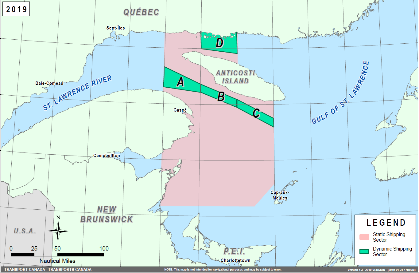
Speed restrictions within the dynamic sectors will be in effect for 15 days, from the date of issuance, and can be extended in the event of continued North Atlantic Right Whales presence. The establishment of speed restriction zones and sectors will be announced through Navigational Warnings.
These restrictions are in effect from April 28 to November 15, 2019. During this period, vessels 20 m or more in length (LOA) shall reduce speed to not exceeding 10.0 knots over the ground in the presence of North Atlantic Right Whales. These dates are subject to change dependent on their presence. Outside of the restriction period, once the mandatory speed restriction has been lifted, vessels are asked to voluntarily reduce their speed to not exceeding 10.0 knots over the ground in the presence of North Atlantic Right Whales, only if maritime conditions permit safe operation of their vessel at that speed.
Navigational Warnings (NAVWARNs) Broadcasts
The Canadian Coast Guard (CCG) continues to promulgate valid Navigational Warnings via radio broadcasts over various terrestrial systems and also online at http://www.marinfo.gc.ca/e-nav or http://nis.ccg-gcc.gc.ca. Mariners shall ensure that they have correct and up-to-date information concerning the protection of the North Atlantic Right Whales as contained in all applicable Notices to Mariners (NOTMARs) and Navigational Warnings.
Canada has replaced its Notice to Shipping (NOTSHIP) with Navigational Warnings (NAVWARNs). NOTSHIPs are no longer being issued. Mariners and other users will be able to search for NAVWARNs, or subscribe to receive NAVWARNs by email, by visiting the following web page: http://nis.ccg-gcc.gc.ca/public/rest/messages/en/search.
Until updates are completed to Canadian nautical charts and publications, Notice to Shipping or NOTSHIPs will continue to be referenced. All references to Notices to Shipping and to NOTSHIPs must be read as meaning Navigational Warnings or NAVWARNs.
Notices to Mariners (NOTMARs) will still be issued as usual and can be searched by visiting the following web page: https://www.notmar.gc.ca/monthly-mensuel-en.php.
Aids to Navigation
In addition, CCG continues to test the use of virtual Automatic Identification System aids to navigation (AIS AtoN), referred in NOTMAR 819(T)/2016. These aids will notify a mariner of a dynamic sector that is subject to a speed restriction. Each dynamic sector will be delimited by four virtual AIS AtoN which could be displayed on the ship’s navigation equipment such as: ECDIS, ECS, RADAR, Minimum Keyboard Display, and Electronic Nautical Charts. The virtual AIS AtoN will be broadcasted only when a speed restriction is in effect in one or more sectors. The mariner is required to select the virtual AIS AtoN symbol to view a message as such: “SectA1 Spd Lim 10 kt.” This message refers to a speed restriction in effect for a specific sector. As this system continues to be in the testing phase, it is not the primary means of communicating with the mariner.
Compliance and Enforcement
Navigational Warnings shall be construed as Notices to Shipping, which must be complied with under section 7 of the Collision Regulations. Failure to comply with any instructions and directions contained in Navigational Warnings could lead to either administrative monetary penalties ranging from Can$6,000 to Can$25,000, or penal sanctions under the Canada Shipping Act, 2001.
If vessels appear to have violated the speed restriction, Transport Canada Marine Safety Inspectors will review all information provided through AIS and seek information from the master. Exemptions to the speed restrictions will not be granted in advance; however, factors such as navigation to ensure vessel safety, weather conditions, force majeure (unforeseen circumstances) and responding to emergencies, will be reviewed and considered by Transport Canada.
Reporting of Whale Sightings
If you see a North Atlantic Right Whale that is entangled, dead, or injured, please report it to your nearest Canadian Coast Guard Marine Communications and Traffic Services Centre, or as follows:
•For the southern part of the Gulf of St. Lawrence:
–Marine Animal Response Society at 1-866-567-6277
•For Newfoundland and Labrador:
–Whale Release and Strandings at 1-709-895-3003
•For the Québec sector:
–Marine Mammal emergencies at 1-877-722-5346
Sightings of live, free-swimming whales should be reported by phone to 1-902-440-8611 (local) or 1-844-800-8568 (toll free) or by email at xmarwhalesightings@dfo-mpo.gc.ca.
*413 SAGUENAY-ST. LAWRENCE MARINE PARK AND SURROUNDING WATERS – WHALE PROTECTION
The waters in and around the Saguenay–St. Lawrence Marine Park are well known for the resident endangered beluga population and the wide diversity of whales that migrate there to feed, particularly between April and November.
REGULATORY PROTECTION MEASURES
All whale species that are found in the St. Lawrence are protected under the Marine Mammal Regulations, pursuant to the Fisheries Act. Within the boundaries of the Marine Park, specific measures are set out in the Marine Activities in the Saguenay–St. Lawrence Marine Park Regulations, pursuant to the establishment of the Saguenay–St. Lawrence Marine Park Act. Any collision with a marine mammal within the Marine Park must immediately be reported to a park warden at 1-866-508-9888. For collisions that occur outside the Marine Park or for any situation involving a marine mammal that is dead or in trouble, contact the emergency network at 1-877-722-5346 or on VHF channel 16.
For more information on the Saguenay–St. Lawrence Marine Park, see notice 5C of the Notices to Mariners Annual Edition 2019.
VOLUNTARY PROTECTION MEASURES
Provisional measures in effect from May 1 to October 31, 2019. See map at the end of this notice.
These measures apply to merchant vessels and cruise ships between Pointe à Boisvert and Cap de la Tête au Chien to prevent collisions with whales. These measures should only be taken when they will not jeopardize navigational safety.
Caution area (yellow area): To reduce the risk of collisions with whales that can be present anywhere in this area, heightened vigilance of navigators is critical. Posting a lookout is recommended in order to increase the chances of seeing the whales and thus taking necessary measures to avoid them. If bypassing the whales is not possible, slow down and wait for the animals to move away to a distance greater than 400 metres (0.215 nautical miles) before resuming original speed. It is more difficult to see the animals at night therefore increased caution is recommended.
Slow down to 10 knots or less area (red area): To reduce the risk of collisions with whales in this feeding area, it is recommended that vessels slow down to a maximum speed through the water of 10 knots and post a lookout. It is further recommended to remain in the Laurentian Channel to the north of Île Rouge to minimize the impact of noise in a sensitive area south of this island, which is highly frequented by herds of beluga whales composed of females and young.
Area to be avoided (hatched red area): To reduce noise and the risk of collisions with whales, vessels should avoid transiting through this area which is highly frequented by blue whales, an endangered species. If the area cannot be avoided, slow down to a speed through the water of 10 knots or less.

*414 SAGUENAY–ST. LAWRENCE MARINE PARK – BELUGA WHALE PROTECTION: SLOWDOWN AREA AT THE MOUTH OF THE SAGUENAY FJORD AND AREA CLOSURE AT BAIE SAINTE-MARGUERITE
The Saguenay–St. Lawrence Marine Park and its surrounding area are at the heart of endangered beluga whale critical summer habitat. Marine mammal protection measures have been put in place in accordance with the Marine Activities in the Saguenay–St. Lawrence Marine Park Regulations within the limits of the Marine Park.
However, important feeding, calving and rearing areas for beluga whales require greater protection to ensure the recovery of the species. The portion of the Saguenay situated between the mouth of the Fjord and Baie Sainte-Marguerite is one of the areas most used by females and their young from May to October. The mouth of the Saguenay is known as a feeding ground and Baie Sainte-Marguerite as a calving and rearing area.
In order to prevent collisions with beluga whales, a compulsory 15-knot slowdown area is in effect from May 1st to October 31st at the mouth of the Saguenay. To ensure tranquility for female belugas and their young during the critical calving period, access to Baie Sainte-Marguerite is prohibited to all vessels from June 21st to September 21st, except for special authorizations (see description below).
For safety reasons, these measures do not apply to cargo ships (see the monthly edition of Notice to Mariners from May to October for voluntary protection measures in the St. Lawrence Estuary). An enhanced vigilance is, however, recommended to all navigators between the mouth of the Saguenay Fjord and Baie Sainte-Marguerite for the protection of beluga whales.
For more information on the Saguenay–St. Lawrence Marine Park, see notice 5C of the Notices to Mariners Annual Edition 2019 or visit http://parcmarin.qc.ca/home/.
REGULATORY PROTECTION MEASURES — BELUGA WHALE
Entire Marine Park Territory:
•When beluga whales are less than half a nautical mile (926 metres) from a motorized vessel, the vessel must maintain a speed of between 5 and 10 knots.
•All vessels, including human-powered vessels (kayaks and canoes), must continue to move forward and maintain their heading.
•All vessels must maintain a minimum distance of 400 metres from beluga whales at all times.
For more information concerning the regulations, consult: http://marinepark.ca/protect/#regulations.
Mouth of the Saguenay Fjord (Figure 1) — Slowdown Area (area cross-hatched in red):
•Maximum
speed at the mouth of the Saguenay between buoys S7 and S8
and the ferry docks between
Baie-Sainte-Catherine and Tadoussac is 15 knots
from May 1st to October
31st.
Baie Sainte-Marguerite (Figure 2) — Area Closure (red area):
•From June 21st to September 21st, vessels must not enter the red area, which follows a line between Cap Nord-Ouest and Cap Sainte-Marguerite.
•Special authorizations are granted only for kayaks, canoes and recreational fishermen who must travel without stopping along a corridor within 10 metres of the shore or in shallow areas.
VOLUNTARY PROTECTION MEASURES
Baie Sainte-Marguerite sector (Figure 2) — Transit Area (area cross-hatched in yellow):
•From June 21st to September 21st, navigation in this area is recommended at a speed of between 5 and 10 knots without stopping.
The purpose of this transit area is to favour respect of the Marine Activities in the Saguenay–St. Lawrence Marine Park Regulations, since beluga whales are often present in the Baie Sainte-Marguerite sector.
INFORMATION
All incidents, including collisions with whales, must be reported without delay by dialling 1-866-508-9888. For any other situation concerning a marine mammal that is either dead or in trouble, contact the emergency network at 1-877-722-5346, or use VHF channel 16.
Figure 1

Figure 2

*415 CANADIAN COAST GUARD - LIST OF CHARTS AND REFERENCE CHARTS (SECTION 1) AFFECTED BY TEMPORARY AND PRELIMINARY NOTICES
IN EFFECT APRIL 26, 2019
(REVISED AND PROMULGATED QUARTERLY)
|
1430 |
1011(T)/18 |
3910 |
314(P)/19 |
|
2017 |
909(T)/14 709(T)/18 |
3936 |
314(P)/19 |
|
2044 |
1005(T)/15 |
3937 |
314(P)/19 |
|
2058 |
809(T)/18 |
3938 |
314(P)/19 |
|
2060 |
814(T)/16 |
3939 |
314(P)/19 |
|
2067 |
1218(T)/16 |
3940 |
314(P)/19 |
|
2077 |
1011(T)/16 |
3974 |
314(P)/19 |
|
2085 |
1205(T)/17 417(T)/19 |
4244 |
1006(T)/14 |
|
2086 |
1219(T)/16 |
4644 |
1106(T)/15 |
|
2123 |
309(T)/17 |
4832 |
313(P)/19 |
|
2181 |
108(T)/17 |
4849 |
207(P)/19 |
|
2235 |
818(T)/16 |
4920 |
416(P)/19 |
|
2315 |
515(T)/16 |
4950 |
208(P)/19 |
|
3463 |
209(P)/19 |
6022 |
1206(T)/17 |
|
3481 |
209(P)/19 |
6287 |
113(T)/17 |
*416(P) PLANS BAIE DES CHALEURS / CHALEUR BAY - CÔTE SUD / SOUTH SHORE – BUOYS TO BE DISCONTINUED
Reference Chart: 4920
The Canadian Coast Guard proposes to permanently discontinue the following buoys:
Bathurst Entrance light buoy EP10 (LL 1330.4) (47° 40’ 27.1”N 065° 36’ 21.1”W)
Bathurst Harbour bifurcation light buoy EP (LL 1334.5) (47° 38’ 01.9”N 065° 39’ 06.9”W)
Bathurst Harbour spar buoy EP43 (LL 6332.71) (47° 38’ 25.5”N 065° 38’ 40.8”W)
Bathurst Harbour spar buoy EP54 (LL 6334.12) (47° 37’ 51.5”N 065° 39’ 01.8”W)
Bathurst Harbour spar buoy EP49 (LL 6334.4) (47° 38’ 04.4”N 065° 39’ 02.6”W)
Comments on this action are solicited from mariners and other interested parties by July 26, 2019, three months following the initial publication date of April 26, 2019. Following this date, this notice will be cancelled. Comments should be directed to the following:
Superintendent, Renee
Pope
Aids to Navigation and
Waterways
Canadian Coast Guard
P.O. Box 5667
St. John’s, NL A1C 5X1
Telephone: (709)
772-2800
Email:
renee.pope@dfo-mpo.gc.ca
Any objections raised must state the facts on which they are based and should include supporting information on safety, commerce and public benefit.
(G2019-021P to 025P)
*417(T) TORONTO HARBOUR – CONSTRUCTION OPERATIONS
Reference Chart: 2085
Construction operations in position 43° 36' 46.84"N 079° 23' 27.99"W and marked by a line of yellow cautionary buoys from September 2018 to December 2020. Tug and barge operation will be placing stone in the water to 0.3 m above chart datum.
Vessels in the area are advised to keep clear of the operation and to contact David G on VHF channel 16 or at 416-938-9607.
*418 TORONTO HARBOUR – CONSTRUCTION OPERATIONS
Reference: Notice 509(T)/18 is cancelled (Chart 2085).
Please see NAVWARN NW-C-0112-19 for other construction operations taking place north of Essroc Quay in line with the Keating Channel.
(NW-C-0112-19)
*419 TORONTO HARBOUR – STONE DELIVERY OFFLOADING
Reference: Notice 1012(T)/18 is cancelled (Chart 2085).
Please see NAVWARN NW-C-0266-19 for new dates concerning this operation.
(NW-C-0266-19)
SECTION 2 - CHART CORRECTIONS
1236 - Port de Rimouski - New Edition - 26-OCT-2012 - NAD 1983
| 05-APR-2019 | LNM/D. 28-DEC-2018 | ||
| Affix |
patch Download Patch - ftp://ftp.dfo-mpo.gc.ca/patches/pa1236-1-20190205.pdf This notice affects Electronic Navigational Chart: CA579041 |
48°28′48.0″N 068°31′00.0″W | |
| DFO(6410013-01) | |||
1236 - Rimouski - New Edition - 26-OCT-2012 - NAD 1983
| 05-APR-2019 | LNM/D. 28-DEC-2018 | ||
| Affix |
patch Download Patch - ftp://ftp.dfo-mpo.gc.ca/patches/pa1236-2-20190306.pdf This notice affects Electronic Navigational Chart: CA579041 |
48°29′08.0″N 068°30′42.0″W | |
| DFO(6410022-01) | |||
1317 - Sault-au-Cochon à/to Québec - New Edition - 22-JUN-2012 - NAD 1983
| 26-APR-2019 | LNM/D. 30-MAR-2018 | ||
| Add |
depth of 10 metres 7 decimetres (See Chart No. 1, I10) This notice affects Electronic Navigational Chart: CA479025 |
46°57′52.7″N 070°49′41.4″W | |
| DFO(6410009-01) | |||
| Delete |
depth of 20 metres 9 decimetres (See Chart No. 1, I10) This notice affects Electronic Navigational Chart: CA479025 |
46°54′10.2″N 070°53′35.0″W | |
| DFO(6410009-02) | |||
| Add |
depth of 19 metres 8 decimetres (See Chart No. 1, I10) This notice affects Electronic Navigational Chart: CA479025 |
46°54′12.9″N 070°53′38.9″W | |
| DFO(6410009-03) | |||
| Add |
depth of 19 metres 3 decimetres (See Chart No. 1, I10) This notice affects Electronic Navigational Chart: CA479025 |
46°54′05.5″N 070°53′40.5″W | |
| DFO(6410009-04) | |||
| Delete |
depth of 21 metres 2 decimetres (See Chart No. 1, I10) This notice affects Electronic Navigational Chart: CA479025 |
46°53′58.2″N 070°53′59.0″W | |
| DFO(6410009-05) | |||
| Add |
depth of 20 metres 1 decimetre (See Chart No. 1, I10) This notice affects Electronic Navigational Chart: CA479025 |
46°53′53.1″N 070°54′07.3″W | |
| DFO(6410009-06) | |||
| Delete |
depth of 21 metres 7 decimetres (See Chart No. 1, I10) This notice affects Electronic Navigational Chart: CA479025 |
46°53′42.6″N 070°54′27.0″W | |
| DFO(6410009-07) | |||
| Add |
depth of 20 metres 8 decimetres (See Chart No. 1, I10) This notice affects Electronic Navigational Chart: CA479025 |
46°53′40.5″N 070°54′29.9″W | |
| DFO(6410009-08) | |||
| Delete |
depth of 26 metres 7 decimetres (See Chart No. 1, I10) This notice affects Electronic Navigational Chart: CA479025 |
46°53′15.4″N 070°55′22.5″W | |
| DFO(6410009-09) | |||
| Add |
depth of 26 metres 1 decimetre (See Chart No. 1, I10) This notice affects Electronic Navigational Chart: CA479025 |
46°53′15.4″N 070°55′24.2″W | |
| DFO(6410009-10) | |||
1317 - Continuation A - New Edition - 22-JUN-2012 - NAD 1983
| 26-APR-2019 | LNM/D. 30-MAR-2018 | ||
| Delete |
depth of 20 metres 9 decimetres (See Chart No. 1, I10) This notice affects Electronic Navigational Chart: CA479025 |
46°54′10.2″N 070°53′35.0″W | |
| DFO(6410009-02) | |||
| Add |
depth of 19 metres 8 decimetres (See Chart No. 1, I10) This notice affects Electronic Navigational Chart: CA479025 |
46°54′12.9″N 070°53′38.9″W | |
| DFO(6410009-03) | |||
| Add |
depth of 19 metres 3 decimetres (See Chart No. 1, I10) This notice affects Electronic Navigational Chart: CA479025 |
46°54′05.5″N 070°53′40.5″W | |
| DFO(6410009-04) | |||
| Delete |
depth of 21 metres 2 decimetres (See Chart No. 1, I10) This notice affects Electronic Navigational Chart: CA479025 |
46°53′58.2″N 070°53′59.0″W | |
| DFO(6410009-05) | |||
| Add |
depth of 20 metres 1 decimetre (See Chart No. 1, I10) This notice affects Electronic Navigational Chart: CA479025 |
46°53′53.1″N 070°54′07.3″W | |
| DFO(6410009-06) | |||
| Delete |
depth of 21 metres 7 decimetres (See Chart No. 1, I10) This notice affects Electronic Navigational Chart: CA479025 |
46°53′42.6″N 070°54′27.0″W | |
| DFO(6410009-07) | |||
| Add |
depth of 20 metres 8 decimetres (See Chart No. 1, I10) This notice affects Electronic Navigational Chart: CA479025 |
46°53′40.5″N 070°54′29.9″W | |
| DFO(6410009-08) | |||
| Delete |
depth of 26 metres 7 decimetres (See Chart No. 1, I10) This notice affects Electronic Navigational Chart: CA479025 |
46°53′15.4″N 070°55′22.5″W | |
| DFO(6410009-09) | |||
| Add |
depth of 26 metres 1 decimetre (See Chart No. 1, I10) This notice affects Electronic Navigational Chart: CA479025 |
46°53′15.4″N 070°55′24.2″W | |
| DFO(6410009-10) | |||
| Delete |
depth of 23 metres 1 decimetre (See Chart No. 1, I10) This notice affects Electronic Navigational Chart: CA479082 |
46°51′47.5″N 070°58′20.2″W | |
| DFO(6410009-11) | |||
| Add |
depth of 22 metres 5 decimetres (See Chart No. 1, I10) This notice affects Electronic Navigational Chart: CA479082 |
46°51′47.8″N 070°58′19.8″W | |
| DFO(6410009-12) | |||
1429 - Canal de la Rive Sud - New Chart - 09-APR-2010 - NAD 1983
| 12-APR-2019 | LNM/D. 23-DEC-2016 | ||
| Delete |
depth of 3 metres 7 decimetres (See Chart No. 1, I10) This notice affects Electronic Navigational Chart: CA579227 |
45°24′25.8″N 073°43′37.5″W | |
| DFO(6410084-01) | |||
| Add |
depth of 3 metres 6 decimetres (See Chart No. 1, I10) This notice affects Electronic Navigational Chart: CA579227 |
45°24′25.5″N 073°43′39.4″W | |
| DFO(6410084-02) | |||
| Replace |
red starboard hand lighted pillar buoy QR, marked A2
with red starboard hand lighted spar buoy QR, marked A2 (See Chart n° 1, Qf) This notice affects Electronic Navigational Chart: CA579227 |
45°24′27.7″N 073°43′24.2″W | |
| (Q2018018) LL(5.3) DFO(6410084-03) | |||
| Add |
private white and orange speed control lighted pillar
buoy FI Y (See Chart n° 1, Qo) This notice affects Electronic Navigational Chart: CA579227 |
45°25′53.5″N 073°41′41.4″W | |
| DFO(6410084-04) | |||
1431 - Baie Saint-François - New Edition - 26-DEC-2014 - NAD 1983
| 26-APR-2019 | LNM/D. 01-FEB-2019 | ||
| Add |
private white and orange spar buoy, Priv OrW (See Chart No. 1, Qp) This notice affects Electronic Navigational Chart: CA573386 |
45°15′20.0″N 074°08′52.6″W | |
| DFO(6604510-01) | |||
| Add |
private yellow spar buoy, Priv Y (See Chart No. 1, Qm) This notice affects Electronic Navigational Chart: CA573386 |
45°15′30.6″N 074°08′13.7″W | |
| DFO(6604510-02) | |||
1431 - Port de Valleyfield - New Edition - 26-DEC-2014 - NAD 1983
| 26-APR-2019 | LNM/D. 01-FEB-2019 | ||
| Affix |
patch Download Patch - ftp://ftp.dfo-mpo.gc.ca/patches/6604535 20190426 1431patch.pdf This notice affects Electronic Navigational Chart: CA573387 |
45°13′24.0″N 074°05′24.0″W | |
| DFO(6604535-01) | |||
1439 - Carleton Island to/au Charity Shoal - New Edition - 08-DEC-2000 - NAD 1983
| 05-APR-2019 | LNM/D. 24-AUG-2018 | ||
| Delete |
red and white fairway lighted pillar buoy, marked
Mo(A) (See Chart No. 1, Qh) This notice affects Electronic Navigational Chart: CA273096, CA373063, CA473036 |
44°01′18.0″N 076°27′42.0″W | |
| (B2018016) LL(391.91) DFO(6604515-01) | |||
2000 - Lake Ontario/Lac Ontario - New Edition - 10-APR-1998 - NAD 1983
| 05-APR-2019 | LNM/D. 08-FEB-2019 | ||
| Delete |
red and white fairway lighted pillar buoy, marked
Mo(A) (See Chart No. 1, Qh) This notice affects Electronic Navigational Chart: CA273096, CA373063, CA473036 |
44°01′45.0″N 076°27′00.0″W | |
| (B2018016) LL(391.91) DFO(6604515-01) | |||
2064 - Kingston to/à False Duck Islands - New Edition - 05-MAR-1999 - NAD 1983
| 05-APR-2019 | LNM/D. 30-JUN-2017 | ||
| Delete |
red and white fairway lighted pillar buoy, marked
Mo(A) (See Chart No. 1, Qh) This notice affects Electronic Navigational Chart: CA273096, CA373063, CA473036 |
44°01′18.0″N 076°27′42.0″W | |
| (B2018016) LL(391.91) DFO(6604515-01) | |||
2257 - Gore Bay - New Edition - 11-JAN-2002 - NAD 1983
| 12-APR-2019 | LNM/D. 30-SEP-2016 | ||
| Affix |
patch Download Patch - ftp://ftp.dfo-mpo.gc.ca/patches/Patch_Document_20190412.pdf This notice affects Electronic Navigational Chart: CA473288 |
45°55′06.0″N 082°27′30.0″W | |
| DFO(6604534-01) | |||
2314 - Port of Thunder Bay - New Edition - 02-NOV-2018 - World Geodetic System 1984
| 26-APR-2019 | |||
| Add |
recommended one way track (See Chart No. 1, M4) |
between 48°22′54.0″N 089°06′02.3″W and 48°22′06.4″N 089°05′00.0″W |
|
| DFO(6604532-01) | |||
| Add |
recommended one way track (See Chart No. 1, M4) |
between 48°22′27.4″N 089°06′45.2″W and 48°21′12.2″N 089°05′00.0″W |
|
| DFO(6604532-02) | |||
| Add |
recommended two way track (See Chart No. 1, M4) |
between 48°21′04.0″N 089°12′04.4″W and 48°20′18.2″N 089°08′58.3″W |
|
| DFO(6604532-03) | |||
| Add |
recommended one way track (See Chart No. 1, M4) |
between 48°20′18.2″N 089°08′58.3″W and 48°19′13.9″N 089°05′00.0″W |
|
| DFO(6604532-04) | |||
| Add |
recommended one way track (See Chart No. 1, M4) |
between 48°20′18.2″N 089°08′58.3″W and 48°19′00.0″N 089°05′18.9″W |
|
| DFO(6604532-05) | |||
4003 - Cape Breton to / à Cape Cod - New Edition - 21-MAR-2003 - NAD 1983
| 12-APR-2019 | LNM/D. 01-MAR-2019 | ||
| Add |
suspended well, depth over wellhead unknown (See Chart No. 1, L21.1) This notice affects Electronic Navigational Chart: CA176140 |
42°50′00.6″N 060°17′48.4″W | |
| DFO(6308611-02) | |||
4025 - Cap Whittle à/to Havre-Saint-Pierre et/and Île d'Anticosti - New Edition - 28-MAR-2014 - NAD 1983
| 12-APR-2019 | LNM/D. 08-MAR-2019 | ||
| Delete |
depth of 21 metres 9 decimetres (See Chart No. 1, I10) This notice affects Electronic Navigational Chart: CA279043 |
50°09′38.7″N 060°23′07.7″W | |
| DFO(6409982-01) | |||
| Add |
depth of 6 metres 4 decimetres (See Chart No. 1, I10) This notice affects Electronic Navigational Chart: CA279043 |
50°09′40.3″N 060°23′26.2″W | |
| DFO(6409982-02) | |||
| Delete |
depth of 2 metres 1 decimetre (See Chart No. 1, I10) This notice affects Electronic Navigational Chart: CA279043 |
50°10′11.6″N 060°17′02.7″W | |
| DFO(6409982-03) | |||
| Add |
rock which covers and uncovers with drying height of 0
metres 1 decimetre (See Chart No. 1, K11) This notice affects Electronic Navigational Chart: CA279043 |
50°10′11.6″N 060°17′04.7″W | |
| DFO(6409982-04) | |||
| Delete |
depth of 4 metres 9 decimetres (See Chart No. 1, I10) This notice affects Electronic Navigational Chart: CA279043 |
50°08′44.0″N 060°19′56.1″W | |
| DFO(6409982-06) | |||
| Add |
depth of 2 metres 8 decimetres (See Chart No. 1, I10) This notice affects Electronic Navigational Chart: CA279043 |
50°08′39.3″N 060°19′49.1″W | |
| DFO(6409982-07) | |||
| Delete |
depth of 11 metres 6 decimetres (See Chart No. 1, I10) This notice affects Electronic Navigational Chart: CA279043 |
50°09′59.5″N 061°13′45.4″W | |
| DFO(6409999-01) | |||
| Add |
depth of 6 metres 5 decimetres (See Chart No. 1, I10) This notice affects Electronic Navigational Chart: CA279043 |
50°09′59.1″N 061°13′58.1″W | |
| DFO(6409999-02) | |||
| Delete |
depth of 5 metres 2 decimetres (See Chart No. 1, I10) This notice affects Electronic Navigational Chart: CA279043 |
50°09′34.7″N 061°06′30.8″W | |
| DFO(6409999-03) | |||
| Add |
depth of 3 metres 2 decimetres (See Chart No. 1, I10) This notice affects Electronic Navigational Chart: CA279043 |
50°09′27.7″N 061°06′19.6″W | |
| DFO(6409999-04) | |||
| Delete |
depth of 7 metres 9 decimetres (See Chart No. 1, I10) This notice affects Electronic Navigational Chart: CA279043 |
50°09′53.8″N 061°01′05.3″W | |
| DFO(6409999-05) | |||
| Add |
depth of 3 metres 2 decimetres (See Chart No. 1, I10) This notice affects Electronic Navigational Chart: CA279043 |
50°09′52.1″N 061°01′04.8″W | |
| DFO(6409999-06) | |||
| Delete |
depth of 3 metres 0 decimetres (See Chart No. 1, I10) This notice affects Electronic Navigational Chart: CA279043 |
50°10′01.0″N 060°40′12.4″W | |
| DFO(6409999-07) | |||
| Add |
depth of 1 metre 3 decimetres (See Chart No. 1, I10) This notice affects Electronic Navigational Chart: CA279043 |
50°09′57.8″N 060°40′17.0″W | |
| DFO(6409999-08) | |||
| Delete |
depth of 14 metres 6 decimetres (See Chart No. 1, I10) This notice affects Electronic Navigational Chart: CA279043 |
50°09′30.7″N 060°33′21.5″W | |
| DFO(6409999-09) | |||
| Add |
depth of 7 metres 3 decimetres (See Chart No. 1, I10) This notice affects Electronic Navigational Chart: CA279043 |
50°09′31.4″N 060°33′12.9″W | |
| DFO(6409999-10) | |||
| Delete |
depth of 3 metres 7 decimetres (See Chart No. 1, I10) This notice affects Electronic Navigational Chart: CA279043 |
50°10′41.2″N 060°25′38.3″W | |
| DFO(6409999-11) | |||
| Add |
depth of 2 metres 0 decimetres (See Chart No. 1, I10) This notice affects Electronic Navigational Chart: CA279043 |
50°10′39.9″N 060°25′29.3″W | |
| DFO(6409999-12) | |||
4201 - Halifax Harbour: Bedford Basin - New Edition - 25-AUG-2017 - NAD 1983
| 12-APR-2019 | LNM/D. 24-AUG-2018 | ||
| Amend |
vertical clearance of 49m, to read 50m (See Chart No. 1, D22) This notice affects Electronic Navigational Chart: CA576003 |
44°39′49.5″N 063°35′03.0″W | |
| DFO(6308609-01) | |||
4202 - Halifax Harbour: Point Pleasant to / à Bedford Basin - New Edition - 26-FEB-2016 - NAD 1983
| 12-APR-2019 | LNM/D. 15-MAR-2019 | ||
| Amend |
vertical clearance of 49m, to read 50m (See Chart No. 1, D22) This notice affects Electronic Navigational Chart: CA576003 |
44°39′49.5″N 063°35′03.0″W | |
| DFO(6308609-01) | |||
4302 - Point Tupper to / à Ship Point - New Chart - 28-SEP-2012 - NAD 1983
| 19-APR-2019 | LNM/D. 20-JUL-2018 | ||
| Amend |
Oc Y 11s 27m 19M to read Oc G 11s27m18M against
light (See Chart No. 1, P16) This notice affects Electronic Navigational Chart: CA476678, CA576680 |
45°34′16.5″N 061°21′24.1″W | |
| (G2019015) LL(694.5) DFO(6308615-01) | |||
| Delete |
Fl 4s 28m 7M against light (See Chart No. 1, P16) This notice affects Electronic Navigational Chart: CA476678, CA576680 |
45°34′16.5″N 061°21′24.1″W | |
| DFO(6308615-02) | |||
| Amend |
F Y 13m 19M to read F G 13m18M against light (See Chart No. 1, P16) This notice affects Electronic Navigational Chart: CA476678, CA576680 |
45°34′13.2″N 061°21′17.5″W | |
| (G2019017) LL(694.4) DFO(6308619-01) | |||
| Delete |
Fl 4s 12m 7M against light (See Chart No. 1, P16) This notice affects Electronic Navigational Chart: CA476678, CA576680 |
45°34′13.2″N 061°21′17.5″W | |
| DFO(6308619-02) | |||
4302 - Strait of Canso - New Chart - 28-SEP-2012 - NAD 1983
| 19-APR-2019 | LNM/D. 20-JUL-2018 | ||
| Amend |
Oc Y 11s 12m 16M to read Oc G 11s12m15M against
light (See Chart No. 1, P16) This notice affects Electronic Navigational Chart: CA476678 |
45°31′12.2″N 061°15′07.4″W | |
| (G2019013) LL(689.3) DFO(6308613-01) | |||
| Delete |
Fl 4s 12m 7M against light (See Chart No. 1, P16) This notice affects Electronic Navigational Chart: CA476678 |
45°31′12.2″N 061°15′07.4″W | |
| DFO(6308613-02) | |||
| Amend |
Oc Y 11s 27m 19M to read Oc G 11s27m18M against
light (See Chart No. 1, P16) This notice affects Electronic Navigational Chart: CA476678, CA576680 |
45°34′16.5″N 061°21′24.1″W | |
| (G2019015) LL(694.5) DFO(6308615-01) | |||
| Delete |
Fl 4s 28m 7M against light (See Chart No. 1, P16) This notice affects Electronic Navigational Chart: CA476678, CA576680 |
45°34′16.5″N 061°21′24.1″W | |
| DFO(6308615-02) | |||
| Amend |
F Y 26m 16M to read F G 26m15M against light (See Chart No. 1, P16) This notice affects Electronic Navigational Chart: CA476678 |
45°31′05.6″N 061°14′53.7″W | |
| (G2019016) LL(689.4) DFO(6308616-01) | |||
| Delete |
Fl 4s 27m 7M against light (See Chart No. 1, P16) This notice affects Electronic Navigational Chart: CA476678 |
45°31′05.6″N 061°14′53.7″W | |
| DFO(6308616-02) | |||
| Amend |
F Y 13m 19M to read F G 13m18M against light (See Chart No. 1, P16) This notice affects Electronic Navigational Chart: CA476678, CA576680 |
45°34′13.2″N 061°21′17.5″W | |
| (G2019017) LL(694.4) DFO(6308619-01) | |||
| Delete |
Fl 4s 12m 7M against light (See Chart No. 1, P16) This notice affects Electronic Navigational Chart: CA476678, CA576680 |
45°34′13.2″N 061°21′17.5″W | |
| DFO(6308619-02) | |||
4307 - Canso Harbour to / au Strait of Canso - New Edition - 04-JAN-2008 - NAD 1983
| 19-APR-2019 | LNM/D. 01-MAR-2019 | ||
| Amend |
Oc Y 11s 39ft to read Oc G 11s39ft against light (See Chart No. 1, P16) This notice affects Electronic Navigational Chart: CA476678 |
45°31′11.8″N 061°15′05.8″W | |
| (G2019013) LL(689.3) DFO(6308613-01) | |||
| Delete |
Fl 4s 41ft against light (See Chart No. 1, P16) This notice affects Electronic Navigational Chart: CA476678 |
45°31′11.8″N 061°15′05.8″W | |
| DFO(6308613-02) | |||
| Amend |
F Y 86ft to read F G 86ft against light (See Chart No. 1, P16) This notice affects Electronic Navigational Chart: CA476678 |
45°31′05.6″N 061°14′53.7″W | |
| (G2019016) LL(689.4) DFO(6308616-01) | |||
| Delete |
Fl 4s 88ft against light (See Chart No. 1, P16) This notice affects Electronic Navigational Chart: CA476678 |
45°31′05.6″N 061°14′53.7″W | |
| DFO(6308616-02) | |||
4308 - St. Peters Bay to / à Strait of Canso - New Edition - 21-MAR-2003 - NAD 1983
| 19-APR-2019 | LNM/D. 01-MAR-2019 | ||
| Amend |
Oc Y 11s 12m to read Oc G 11s12m against light (See Chart No. 1, P16) This notice affects Electronic Navigational Chart: CA476678 |
45°31′12.2″N 061°15′07.4″W | |
| (G2019013) LL(689.3) DFO(6308613-01) | |||
| Delete |
Fl 4s 13m against light (See Chart No. 1, P16) This notice affects Electronic Navigational Chart: CA476678 |
45°31′12.2″N 061°15′07.4″W | |
| DFO(6308613-02) | |||
| Amend |
F Y 26m to read F G 26m against light (See Chart No. 1, P16) This notice affects Electronic Navigational Chart: CA476678 |
45°31′05.6″N 061°14′53.7″W | |
| (G2019016) LL(689.4) DFO(6308616-01) | |||
| Delete |
Fl 4s 27m against light (See Chart No. 1, P16) This notice affects Electronic Navigational Chart: CA476678 |
45°31′05.6″N 061°14′53.7″W | |
| DFO(6308616-02) | |||
4335 - Strait of Canso and Approaches / et les approches - New Edition - 04-JAN-2008 - NAD 1983
| 19-APR-2019 | LNM/D. 01-MAR-2019 | ||
| Amend |
Oc Y to read Oc G against light (See Chart No. 1, P16) This notice affects Electronic Navigational Chart: CA476678 |
45°31′12.2″N 061°15′07.4″W | |
| (G2019013) LL(689.3) DFO(6308613-01) | |||
| Delete |
Fl against light (See Chart No. 1, P16) This notice affects Electronic Navigational Chart: CA476678 |
45°31′12.2″N 061°15′07.4″W | |
| DFO(6308613-02) | |||
| Amend |
Oc Y to read Oc G against light (See Chart No. 1, P16) This notice affects Electronic Navigational Chart: CA476678, CA576680 |
45°34′16.5″N 061°21′24.1″W | |
| (G2019015) LL(694.5) DFO(6308615-01) | |||
| Delete |
Fl against light (See Chart No. 1, P16) This notice affects Electronic Navigational Chart: CA476678, CA576680 |
45°34′16.5″N 061°21′24.1″W | |
| DFO(6308615-02) | |||
| Amend |
FY to read F G against light (See Chart No. 1, P16) This notice affects Electronic Navigational Chart: CA476678 |
45°31′05.6″N 061°14′53.7″W | |
| (G2019016) LL(689.4) DFO(6308616-01) | |||
| Delete |
Fl against light (See Chart No. 1, P16) This notice affects Electronic Navigational Chart: CA476678 |
45°31′05.6″N 061°14′53.7″W | |
| DFO(6308616-02) | |||
| Amend |
F Y to read F G against light (See Chart No. 1, P16) This notice affects Electronic Navigational Chart: CA476678, CA576680 |
45°34′13.2″N 061°21′17.5″W | |
| (G2019017) LL(694.4) DFO(6308619-01) | |||
| Delete |
Fl against light (See Chart No. 1, P16) This notice affects Electronic Navigational Chart: CA476678, CA576680 |
45°34′13.2″N 061°21′17.5″W | |
| DFO(6308619-02) | |||
4405 - Pictou Island to / aux Tryon Shoals - New Edition - 21-FEB-2003 - NAD 1983
| 12-APR-2019 | LNM/D. 08-MAR-2019 | ||
| Add |
light Fl R (See Chart No. 1, P1) This notice affects Electronic Navigational Chart: CA376161 |
45°47′37.1″N 063°02′45.1″W | |
| (G2019012) LL(920.1) DFO(6308598-01) | |||
4425 - St. Peters Bay - New Edition - 01-NOV-2002 - NAD 1983
| 26-APR-2019 | LNM/D. 08-MAR-2019 | ||
| Add | legend See CAUTION/Voir ATTENTION | 46°27′24.0″N 062°44′30.0″W | |
| DFO(6308569-03) | |||
4425 - Tracadie Bay - New Edition - 01-NOV-2002 - NAD 1983
| 26-APR-2019 | LNM/D. 08-MAR-2019 | ||
| Reposition | legend Channel Buoyed/Chenal balisé |
from 46°25′17.0″N 063°02′15.0″W to 46°25′09.0″N 063°00′40.0″W |
|
| DFO(6308569-01) | |||
| Add | legend See CAUTION/Voir ATTENTION | 46°25′12.0″N 063°01′26.0″W | |
| DFO(6308569-02) | |||
4452 - Baie Coacoachou - New Edition - 22-MAR-2013 - NAD 1983
| 12-APR-2019 | LNM/D. 22-MAR-2019 | ||
| Add |
depth of 3 metres 7 decimetres (See Chart No. 1, I10) This notice affects Electronic Navigational Chart: CA479137 |
50°14′21.2″N 060°17′44.7″W | |
| DFO(6409982-05) | |||
| Affix |
patch Download Patch - ftp://ftp.dfo-mpo.gc.ca/patches/pa4452-20190308-1.pdf This notice affects Electronic Navigational Chart: CA479137 |
50°10′00.0″N 060°23′02.0″W | |
| DFO(6410079-01) | |||
| Affix |
patch Download Patch - ftp://ftp.dfo-mpo.gc.ca/patches/pa4452-20190308-2.pdf This notice affects Electronic Navigational Chart: CA479137 |
50°10′00.0″N 060°17′48.0″W | |
| DFO(6410080-01) | |||
4452 - Havres et Mouillages - Harbours and Anchorages - New Edition - 22-MAR-2013 - NAD 1983
| 12-APR-2019 | LNM/D. 22-MAR-2019 | ||
| Affix |
patch Download Patch - ftp://ftp.dfo-mpo.gc.ca/patches/pa4452-20190308-3.pdf |
Below the chart title block | |
| DFO(6409982-08) | |||
4456 - Baie Piashti à/to Petite Île au Marteau - New Edition - 30-AUG-2013 - NAD 1983
| 05-APR-2019 | LNM/D. 08-MAR-2019 | ||
| Add |
depth of 6 metres 6 decimetres (See Chart No. 1, I10) This notice affects Electronic Navigational Chart: CA379131 |
50°11′43.1″N 063°23′55.0″W | |
| DFO(6410078-01) | |||
| Add |
depth of 7 metres 4 decimetres (See Chart No. 1, I10) This notice affects Electronic Navigational Chart: CA379131 |
50°11′26.5″N 063°24′05.2″W | |
| DFO(6410078-02) | |||
| Add |
depth of 9 metres 5 decimetres (See Chart No. 1, I10) This notice affects Electronic Navigational Chart: CA379131 |
50°11′28.6″N 063°24′31.7″W | |
| DFO(6410078-03) | |||
| Add |
depth of 16 metres 8 decimetres (See Chart No. 1, I10) This notice affects Electronic Navigational Chart: CA379131 |
50°11′24.0″N 063°25′06.7″W | |
| DFO(6410078-04) | |||
| Delete |
depth of 25 metres 6 decimetres (See Chart No. 1, I10) This notice affects Electronic Navigational Chart: CA379131 |
50°11′09.6″N 063°25′35.4″W | |
| DFO(6410078-05) | |||
| Add |
depth of 21 metres 4 decimetres (See Chart No. 1, I10) This notice affects Electronic Navigational Chart: CA379131 |
50°11′12.1″N 063°25′33.4″W | |
| DFO(6410078-06) | |||
| Delete |
depth of 17 metres 5 decimetres (See Chart No. 1, I10) This notice affects Electronic Navigational Chart: CA379131 |
50°11′36.6″N 063°25′55.2″W | |
| DFO(6410078-07) | |||
| Add |
depth of 14 metres 6 decimetres (See Chart No. 1, I10) This notice affects Electronic Navigational Chart: CA379131 |
50°11′37.6″N 063°25′52.3″W | |
| DFO(6410078-08) | |||
4474 - Baie de la Tabatière - New Edition - 28-MAY-1999 - NAD 1983
| 05-APR-2019 | LNM/D. 08-MAR-2019 | ||
| Delete |
depth of 3 fathoms 0 feet (See Chart No. 1, I10) |
15°06′, 1136 m from South West corner of inset border |
|
| DFO(6410076-01) | |||
| Add |
depth of 2 fathoms 2 feet (See Chart No. 1, I10) |
14°38′, 1137 m from South West corner of inset border |
|
| DFO(6410076-02) | |||
| Delete |
depth of 5 fathoms 0 feet (See Chart No. 1, I10) |
19°33′, 1156 m from South West corner of inset border |
|
| DFO(6410076-03) | |||
| Add |
depth of 4 fathoms 2 feet (See Chart No. 1, I10) |
19°23′, 1162 m from South West corner of inset border |
|
| DFO(6410076-04) | |||
| Add |
depth of 5 fathoms 4 feet (See Chart No. 1, I10) |
19°47′, 1057 m from South West corner of inset border |
|
| DFO(6410076-05) | |||
| Add |
depth of 2 fathoms 1 foot (See Chart No. 1, I10) |
29°14′, 1212 m from South West corner of inset border |
|
| DFO(6410076-06) | |||
| Delete |
depth of 6 fathoms 0 feet (See Chart No. 1, I10) |
31°20′, 1044 m from South West corner of inset border |
|
| DFO(6410076-07) | |||
| Add |
depth of 4 fathoms 0 feet (See Chart No. 1, I10) |
31°33′, 1048 m from South West corner of inset border |
|
| DFO(6410076-08) | |||
4483 - Caribou Harbour - New Edition - 10-JAN-2003 - NAD 1983
| 05-APR-2019 | LNM/D. 04-MAY-2018 | ||
| Reposition |
light Iso (See Chart No. 1, P1) This notice affects Electronic Navigational Chart: CA376691, CA576464 |
from 45°48′14.2″N 062°35′11.7″W to 45°48′13.6″N 062°35′08.1″W |
|
| (G2019004) LL(899) DFO(6308558-01) | |||
4641 - Channel - Port aux Basques - New Edition - 31-OCT-2014 - NAD 1983
| 26-APR-2019 | LNM/D. 27-JUL-2018 | ||
| Affix |
patch Download Patch - ftp://ftp.dfo-mpo.gc.ca/patches/PortAuxBasques_Patch_4641v1PA1.pdf This notice affects Electronic Navigational Chart: CA576304 |
47°34′30.0″N 059°08′24.0″W | |
| DFO(6308629-01) | |||
4659 - Port au Port - New Edition - 01-AUG-2003 - NAD 1983
| 26-APR-2019 | LNM/D. 15-MAR-2019 | ||
| Add |
wreck WK with known depth of 12 fathoms (See Chart No. 1, K26) |
48°36′50.5″N 058°46′50.3″W | |
| DFO(6308610-01) | |||
4849 - Catalina Harbour - New Chart - 30-DEC-1988 - NAD 1983
| 26-APR-2019 | LNM/D. 11-JAN-2019 | ||
| Affix |
patch Download Patch - ftp://ftp.dfo-mpo.gc.ca/patches/4849v1PA9 - Catalina Harbour Patch.pdf This notice affects Electronic Navigational Chart: CA576394 |
48°31′00.0″N 053°04′30.0″W | |
| DFO(6308617-01) | |||
4863 - Bacalhao Island to / à Black Island - New Edition - 30-NOV-2001 - NAD 1983
| 12-APR-2019 | LNM/D. 22-MAR-2019 | ||
| Add |
marine farm (See Chart No. 1, K48.2) This notice affects Electronic Navigational Chart: CA476168 |
49°23′48.6″N 054°44′46.8″W | |
| DFO(6308612-01) | |||
4865 - Approaches to / Approches à Lewisporte and / et Loon Bay - New Edition - 27-MAY-2005 - NAD 1983
| 12-APR-2019 | LNM/D. 28-OCT-2016 | ||
| Add |
marine farm (See Chart No. 1, K48.2) This notice affects Electronic Navigational Chart: CA476168 |
49°23′48.6″N 054°44′46.8″W | |
| DFO(6308612-01) | |||
6415 - Three Finger Creek to/à Saline Island Kilometre 650 / Kilometre 730 - New Edition - 24-JUL-2009 - NAD 1983
| 12-APR-2019 | |||
| Delete |
red starboard hand conical buoy (See Chart No. 1, Qf) |
63°58′22.8″N 124°12′38.3″W | |
| (A2018076) DFO(6604495-01) | |||
| Delete |
red starboard hand conical buoy (See Chart No. 1, Qf) |
63°58′30.7″N 124°13′06.9″W | |
| (A2018077) DFO(6604496-01) | |||
| Delete |
green port hand can buoy (See Chart No. 1, Qg) |
63°58′21.3″N 124°14′50.4″W | |
| (A2018078) DFO(6604497-01) | |||
| Delete |
green port hand can buoy (See Chart No. 1, Qg) |
63°58′17.4″N 124°15′24.9″W | |
| (A2018079) DFO(6604498-01) | |||
6424 - Bryan Island to/à Travaillant River Kilometre 1240 / Kilomètre 1325 - New Edition - 30-JAN-2015 - World Geodetic System 1984
| 26-APR-2019 | LNM/D. 14-JUL-2017 | ||
| Delete |
combined leading beacons and pecked line (See Chart No. 1, Q120, Pe) |
between 67°27′05.1″N 131°19′34.0″W and 67°27′24.0″N 131°20′49.4″W |
|
| DFO(6604524-01) | |||
| Add |
starboard hand daybeacon (See Chart No. 1, Qt) |
67°27′07.0″N 131°19′36.0″W | |
| DFO(6604524-02) | |||
| Reposition |
red starboard hand conical buoy (See Chart No. 1, Qf) |
from 67°27′02.2″N 130°53′45.7″W to 67°27′03.4″N 130°53′21.4″W |
|
| DFO(6604524-03) | |||
| Add |
red starboard hand conical buoy (See Chart No. 1, Qf) |
67°27′26.9″N 130°53′18.8″W | |
| DFO(6604524-04) | |||
| Reposition |
green port hand can buoy (See Chart No. 1, Qg) |
from 67°27′41.0″N 130°54′40.0″W to 67°27′48.5″N 130°54′24.4″W |
|
| DFO(6604524-05) | |||
| Reposition |
green port hand can buoy (See Chart No. 1, Qg) |
from 67°28′13.2″N 130°56′11.8″W to 67°28′15.5″N 130°55′55.1″W |
|
| DFO(6604524-06) | |||
| Add |
red starboard hand conical buoy (See Chart No. 1, Qf) |
67°20′20.5″N 130°45′55.2″W | |
| DFO(6604524-07) | |||
| Reposition |
red starboard hand conical buoy (See Chart No. 1, Qf) |
from 67°20′24.9″N 130°47′24.4″W to 67°20′28.7″N 130°47′15.7″W |
|
| DFO(6604524-08) | |||
| Reposition |
green port hand can buoy (See Chart No. 1, Qg) |
from 67°13′52.1″N 130°19′07.1″W to 67°13′59.4″N 130°19′30.3″W |
|
| DFO(6604524-09) | |||
| Reposition |
red starboard hand conical buoy (See Chart No. 1, Qf) |
from 67°14′04.6″N 130°19′32.1″W to 67°14′04.1″N 130°19′49.1″W |
|
| DFO(6604524-10) | |||
6425 - Travaillant River to/à Adam Cabin Creek Kilometre 1325 / Kilomètre 1400 - New Edition - 15-JAN-2016 - World Geodetic System 1984
| 26-APR-2019 | LNM/D. 23-MAR-2018 | ||
| Delete |
green port hand can buoy (See Chart No. 1, Qg) |
67°20′19.4″N 132°10′40.7″W | |
| DFO(6604523-01) | |||
| Reposition |
red starboard hand conical buoy (See Chart No. 1, Qf) |
from 67°19′18.7″N 132°16′32.4″W to 67°19′17.8″N 132°17′01.8″W |
|
| DFO(6604523-02) | |||
| Reposition |
port hand daybeacon (See Chart No. 1, Qt) |
from 67°17′08.0″N 132°34′10.1″W to 67°16′56.6″N 132°34′52.1″W |
|
| DFO(6604523-03) | |||
| Reposition |
red starboard hand conical buoy (See Chart No. 1, Qf) |
from 67°16′29.9″N 132°34′40.0″W to 67°16′28.6″N 132°35′06.4″W |
|
| DFO(6604523-04) | |||
| Reposition |
green port hand can buoy (See Chart No. 1, Qg) |
from 67°16′02.6″N 132°35′08.6″W to 67°16′11.0″N 132°35′35.5″W |
|
| DFO(6604523-05) | |||
| Reposition |
green port hand can buoy (See Chart No. 1, Qg) |
from 67°15′25.0″N 132°35′47.3″W to 67°15′38.9″N 132°35′59.2″W |
|
| DFO(6604523-06) | |||
| Reposition |
green port hand can buoy (See Chart No. 1, Qg) |
from 67°15′03.3″N 132°36′11.5″W to 67°15′08.1″N 132°36′24.1″W |
|
| DFO(6604523-07) | |||
| Reposition |
port hand daybeacon (See Chart No. 1, Qt) |
from 67°22′13.3″N 131°58′12.3″W to 67°22′14.6″N 131°56′40.8″W |
|
| DFO(6604523-08) | |||
| Reposition |
red starboard hand conical buoy (See Chart No. 1, Qf) |
from 67°21′58.8″N 131°56′55.2″W to 67°22′08.6″N 131°56′01.1″W |
|
| DFO(6604523-09) | |||
| Reposition |
green port hand can buoy (See Chart No. 1, Qg) |
from 67°21′51.8″N 131°51′28.0″W to 67°21′43.1″N 131°52′20.3″W |
|
| DFO(6604523-10) | |||
| Reposition |
starboard hand daybeacon (See Chart No. 1, Qt) |
from 67°21′38.0″N 131°51′00.2″W to 67°21′34.0″N 131°51′33.2″W |
|
| DFO(6604523-11) | |||
| Reposition |
starboard hand daybeacon (See Chart No. 1, Qt) |
from 67°22′02.3″N 131°49′14.5″W to 67°21′47.8″N 131°50′23.4″W |
|
| DFO(6604523-12) | |||
| Reposition |
green port hand can buoy (See Chart No. 1, Qg) |
from 67°22′23.9″N 131°48′48.9″W to 67°22′17.3″N 131°49′37.2″W |
|
| DFO(6604523-13) | |||
| Reposition |
port hand daybeacon (See Chart No. 1, Qt) |
from 67°19′36.1″N 132°16′11.9″W to 67°19′34.9″N 132°16′33.2″W |
|
| DFO(6604523-14) | |||
7668 - Holman - New Chart - 18-MAY-1990 - NAD 1927
| 12-APR-2019 | LNM/D. 21-MAR-2008 | ||
| Affix |
patch Download Patch - ftp://ftp.dfo-mpo.gc.ca/patches/7668PA_20190412.pdf |
70°43′48.0″N 117°46′00.0″W | |
| DFO(6604533-01) | |||
SECTION 3 - RADIO AIDS TO MARINE NAVIGATION CORRECTIONS
NO CORRECTIONS FOR THIS SECTION.
SECTION 4 - SAILING DIRECTIONS AND SMALL CRAFT GUIDE CORRECTIONS
Chapter 1 — Paragraph 176, last line
Add:An obstruction, reported in 2018, with a least depth of 26 feet (8 m) is located about 2 miles NNE of Bide Head; caution is advised.
(N2019-01.4)
Chapter 1 — Adjacent to paragraph 176, add a caution pictograph.
(N2019-01.5)
Chapter 5 — Paragraph 92
Delete: DX9
Replace by: DH1
(N2019-01.6)
Chapter 6 — Paragraph 346
Delete: 2.1 to 5.6 m (7 to
18 ft)
Replace by: 2.1 to 5.3 m (7 to 17 ft)
(N2019-01.7)
Chapter 6 — Paragraph 348
Delete: “depth of 4 m
(13 ft) … 3 m (10 ft) wide outer
end”
Replace by:least depth of 4.3 m (14 ft) alongside its outer 70 m (230 ft) and 50 m (164 ft) lengths of its east and west sides, respectively,
(N2019-01.8)
Chapter 6 — Delete paragraph 349
Replace by:349 The Public pier, 77 m (253 ft) long and 8 m (26 ft) wide, with depths of 2.8 to 4 m (9 to 13 ft) alongside its south face, is situated in the NE corner of the harbour; a bait depot is located adjacent to this pier. A light (448) is shown from a mast located on the outer end of the pier. The north side of the pier has depths of 1.3 to 3.1 m (4 to 10 ft) alongside. A depth of 2.7 m (9 ft) is charted about 20 m (66 ft) WNW of the outer end of the Public pier. A wharf, 64 m (209 ft) long, with depths of 1.3 to 2.8 m (4 to 9 ft) alongside, extends in a NW direction from the inner end of the Public pier. Another wharf, 61 m (200 ft) long with a least depth of 1.5 m (5 ft), extends SE from the inner end of the Public pier.
(N2019-01.9)
Chapter 2 — Delete paragraph 63
Replace by:63 At the entrance to Admirals Marina there is a Public breakwater-wharf extending 85 m (279 ft) from the shore. The east side of the wharf has depths of 3.3 to 4.8 m (11 to 16 ft) alongside. The outer 70 m (230 ft) length of the west side of the wharf has depths of 2.5 to 5.3 m (8 to 17 ft). A light (482.789) is shown from a mast on the outer end of the Public breakwater-wharf. Another wharf 56 m (184 ft) long with depths of 2.8 to 3.3 m (9 to 11 ft) alongside extends east from the inner end of the breakwater-wharf.
(N2019-02.0)
Chapter 2 — Paragraph 139, last line
Add:An Ocean Data Acquisition System (ODAS) light buoy, privately maintained, is moored about 0.38 mile NNE of Joys Point.
(N2019-02.1)
Chapter 2 — Paragraph 157
Delete: 7.1 to 8.1 m (23 to
27 ft)
Replace by: 6.8 to 8.1 m (22 to 27 ft)
(N2019-02.2)
Chapter 2 — Paragraph 158
Delete: 2.8 m (9 ft)
Replace by: 2.6 m (9 ft) in the approach to its SW
end
(N2019-02.3)
Chapter 3 — Paragraph 29
Delete: “An Ocean
Data … Cape
Spear.”
Replace by:Ocean Data Acquisition System (ODAS) light buoys, privately maintained, are moored 1.5 and 2.5 miles ENE and north, respectively, of Cape Spear.
(N2019-02.4)
Chapter 5 — Paragraph 39, last line
Add:An obstruction, depth unknown, is charted about 0.28 mile WSW of Isaac Point; caution is advised.
(N2019-02.5)
Chapter 5 — Adjacent to paragraph 39.1, add a caution pictograph.
(N2019-02.6)
Chapter 5 — Paragraph 106, after “4.1 m
(13 ft)”
Insert: and marked by starboard hand light
buoy EA2 (38.75)
(N2019-02.7)
Chapter 6 — Paragraph 248, last line
Add:Another fish haven (artificial reef) with a least depth of 10.3 m (34 ft) is charted 0.6 mile NE of the Public wharf at North Harbour.
(N2019-02.8)
Chapter 1 — Paragraph 39
Delete: 12 fathoms (21.9 m)
Replace by: 52 feet (15.8 m)
(N2019-02.9)
Chapter 1 — Paragraph 40, last line
Add:A rock with a least depth of 1 foot (0.3 m) is located 0.1 mile SW of the south island of the Little Green Islands.
(N2019-03.0)
Chapter 1 — Paragraph 53, last line
Add:Wrecks with depths of 31 and 35 fathoms (57 and 64 m) are charted near mid-channel in La Baie.
(N2019-03.1)
Chapter 1 — Paragraph 116, last line
Add:Shoals with least depths of 26 feet (7.9 m) and 25 feet (7.6 m) are charted 0.7 mile NE and 1.2 miles SE, respectively, of Pointe aux Soldats. Depths of 12 and 17 feet (3.7 and 5.2 m) are charted about 2 miles west of the previous shoals. Isolated shoals with a least depth of 32 feet (9.8 m) and lying about 3 miles off the coast are located about 3.5 miles SE of Pointes de Belliveau. Another isolated shoal with a least depth of 34 feet (10.4 m) is located about 6 miles south of Pointes de Belliveau.
(N2019-03.2)
Chapter 2 — After paragraph 50
Insert:50.1 A flashing yellow light marks an underwater turbine, which is situated mid-channel, north of Peter Island. Caution is advised.
(A2019-006.6)
Chapter 2 — Adjacent to paragraph 50.1, add a caution pictograph.
(A2019-006.7)
Chapter 4 — Delete paragraph 11.1.
(A2019-006.5)
Chapter 1 — Paragraph 40, after “boat ramp.”
Insert: Starboard and port hand light buoys XM6 (235.8) and XM5 (235.7) are moored close north of the floating wharves and boat ramp.
(N2019-03.3)
Chapter 3 — Paragraph 145, last line
Add:A rock, drying 6 feet (1.8 m), is located about 0.6 mile ENE of Western Head.
(N2019-03.4)
Chapter 3 — Adjacent to paragraph 145, add a caution pictograph.
(N2019-03.5)
Chapter 4 — Paragraph 4, last line
Add:A drying rock dangerous to navigation is charted about 0.5 mile WSW of North Head; caution is advised.
(N2019-03.6)
Chapter 4 — Adjacent to paragraph 4, add a caution pictograph.
(N2019-03.7)
Chapter 1 — Paragraph 41
Delete: 76 m
Replace by: 94 m
(Q2019-014.1)
Chapter 1 — Paragraph 45, last line
Add:Approximately halfway between the entrance of the bay to the anchorage there is a shoal near mid-channel with a depth of 2.6 m.
(Q2019-014.2)
Chapter 1 — Adjacent to paragraph 45, add a caution pictograph.
(Q2019-014.3)
Chapter 3 — In the vicinity of paragraph 197,
Table 3.5 Port of Rimouski Wharves
Make the following changes in the
“Depth
†”
column.
| Berth | Depth † | |
|---|---|---|
| metres | ||
| 1 | 4.3 | |
| 2 | 3.6 | |
| 3 | 5.7 | |
| 5 | 4.7 |
(Q2019-004.1)
Chapter 2 — In the vicinity of paragraph 127, Table 2.4 Port of Québec: Private Berths
Make the following changes in the “Wharf Length” column.
| Berth | Wharf Length | |
|---|---|---|
| m | ||
| 93 | 134 | |
| 94 | 106 | |
| 95 | 99 | |
| 96 | 89 | |
| 97 | 117 | |
| 98 | 113 |
(Q2019-016.1)
Chapter 4 — Paragraph 11
Delete: “A rocky ledge … N
from Nodoway Point.”
Replace by:A rocky ledge extends about 2 [1.7] miles north from Nodoway Point.
(C2019-006.01)
Chapter 4 — After paragraph 11
Insert:11.1 There are several submerged buoys located around the outer edges of Whitefish Bay, specifically near Pendills Bay, north of Tahquamenon Bay and near Whitefish Point. These buoys float about 5 feet [1.5 m] from the lake bottom and are tethered to hydroacoustic receivers and concrete blocks. A line of floating rope is also attached to the concrete block in order to facilitate the recovery of the buoy and receiver. Mariners are urged to use caution in the vicinity of these buoys shown on chart 14962.
(C2019-006.02)
Chapter 6 — After paragraph 99
Insert:99.1 Caution. — A potable water intake extends 0.2 mile offshore slightly west of French Island and ends in a submerged crib.
(C2019-007.01)
Chapter 6 — Adjacent to paragraph 99.1, add a caution pictograph.
(C2019-007.02)
Chapter 8 — Paragraph 42, after “(Cumberland sector).”
Insert:A seasonal ice boom is placed between December 15 and March 31 and removed as soon as ice conditions allow for navigation.
(Q2019-022.1)
Chapter 8 — Adjacent to paragraph 42, add a caution pictograph.
(Q2019-022.2)
Chapter 9 — Paragraph 112, last line
Add:Private buoys also mark a swimming area in the sector.
(Q2019-021.1)
SECTION 5 - LIST OF LIGHTS, BUOYS AND FOG SIGNALS CORRECTIONS
The amendments are highlighted and deletions are crossed out. For general and region-specific
information on the List of Lights, click on the following links:
Newfoundland and Labrador Coast,
Atlantic Coast,
Inland Waters and
Pacific Coast.
ATLANTIC COAST
| No. | Name |
Position ----- Latitude N. Longitude W. |
Light Characteristics |
Focal Height in m. above water |
Nominal Range |
Description ----- Height in meters above ground |
Remarks ----- Fog Signals |
|||
|---|---|---|---|---|---|---|---|---|---|---|
NOVA SCOTIA, SOUTHEAST COAST (LL 327 – 664.8, 666.8 – 684.02) |
||||||||||
|
629 H3514 |
Port Bickerton |
Near W. extremity of Barachois Head. 45 05 24.0 061 42 01.7 |
Fl | W | 3s | 20.6 | 17 |
White square
building with red roof and white square tower with red
top. 9.2 |
Flash 1 s; eclipse 2 s. Visible from 280° through N. and E. to 136°. Year round. Horns(2) – Blast 3 s; sil. 3 s; blast 3 s; sil. 51 s. Horns point 156° and sound in unison. Chart:4234 Edn 04/19 (G19-019) |
|
|
639 H3504 |
Country Island |
S. side of island. 45 05 59.8 061 32 31.9 |
Fl | W | 20s | 16.5 | ….. |
White octagonal tower with red top. 13.7 |
Flash 2 s; eclipse 18 s. Year round. Chart:4233 Edn 04/19 (G19-018) |
|
NOVA SCOTIA AND CAPE BRETON ISLAND (LL 686.5 – 704.1) |
||||||||||
|
689.3 H3421 689.4 H3421.1 |
Eddy Point range |
| | | | | | | | | | | | |
SE. entrance, Strait of Canso. 45 31 12.2 061 15 07.4 124°51' 361.0 m from front. |
Oc F |
G G |
11s ….. |
11.9 26.1 |
15 15 |
Triangular skeleton tower, white daymark with red vertical
stripe. 12.3 Triangular skeleton tower, white daymark with red vertical stripe. 19.0 |
Flash 10 s; eclipse 1 s. Visible in line of range. Operates 24 h. Year round. Visible in line of range. Operates 24 h. Year round. Chart:4302 Edn 04/19 (G19-013, 016) |
|
694.4 H3427 694.5 H3427.1 |
Laceys Rocks (Cahil Rock) range |
| | | | | | | | | | |
SE. of
rocks. 45 34 13.2 061 21 17.5 304°46' 176.1 m from front. |
F Oc |
G G |
..... 11s |
12.9 27.5 |
18 18 |
Triangular skeleton tower, white daymark with red vertical
stripe. 12.7 Triangular skeleton tower, white daymark with red vertical stripe. 12.3 |
Visible in line of range. Operates 24 h. Year round. Flash 10 s; eclipse 1 s. Visible in line of range. Operates 24 h. Year round. Chart:4302 Edn 04/19 (G19-015, 017) |
GULF OF ST. LAWRENCE (LL 883.2 – 940.3, 1169.1 – 1426, 1477.5 – 1584) |
||||||||||
|
899 H1237 |
Pictou Island South |
On SW. coast of island. 45 48 13.6 062 35 08.1 |
Iso | W | 4s | 10.8 | 8 |
White pyramid tower
with red
top. 8.1 |
Seasonal. Chart:4483 Edn 04/19 (G19-004) |
|
| 920.1 | Skinners Cove Wharf Light |
On NE. corner of W.
breakwater. 45 47 40.2 063 02 40.6 |
Fl | R | 4s | 6.3 | 4 |
Square skeleton
tower, red and white rectangular daymark. 5.5 |
Flash 1 s; eclipse
3 s. Seasonal. Chart:4405 Edn 04/19 (G19-012) |
|
ST. LAWRENCE RIVER (LL 1584.5 – 1772, 1823.8 – 2185.7, 2273 – 2365.95) |
||||||||||
| 2030 | Cap à la Roche Curve light buoy D31 |
Deschaillons-sur-Saint-Laurent. 46 33 48.4 072 06 47.6 |
Q | G | 1s | ..... | ..... | Green spar, marked “D31”. |
Year round. Chart:1314 Edn 04/19 (Q19-072) |
|
| 2039 | Traverse de Batiscan Curve light buoy D54 |
Cap
Lévrard. 46 32 04.9 072 10 48.9 |
Q | R | 1s | ..... | ..... | Red spar, marked “D54”. |
Year round. Chart:1314 Edn 04/19 (Q19-073) |
|
| 2338.5 | Traverse de Varennes light buoy M138 |
Île
Sainte-Thérèse. 45 40 51.6 073 27 21.8 |
Fl | R | 4s | ..... | ..... | Red spar, marked “M138”. |
Year
round. Chart:1310 Edn 04/19 (Q19-074) |
|
INLAND WATERS
| No. | Name |
Position ----- Latitude N. Longitude W. |
Light Characteristics |
Focal Height in m. above water |
Nominal Range |
Description ----- Height in meters above ground |
Remarks ----- Fog Signals |
|||
|---|---|---|---|---|---|---|---|---|---|---|
ST. LAWRENCE SEAWAY (LL 0.1 – 78, 84 – 141.5, 143 – 158, 164 – 353, 372 – 391.92, 1193 – 1204.5) |
||||||||||
| 391.91 | East Charity Shoal Traffic light buoy (U.S.) |
Delete from
list. Chart:1439 Edn 04/19 (B18-016) |
||||||||
CANADIAN COAST GUARD - MARINE INFORMATION REPORT AND SUGGESTION SHEET
Name of Ship or Sender:..................................................................... Date:....................................
Address of Sender:..........................................................................................................................
Street # Street Name
Town / City:.............................. Prov / State:....................... Postal Code / Zip Code: ........................
Tel / Fax / E-mail address of sender (if appropriate):............................................................................
Observation Date:............................................. Time (UTC): ...........................................................
Geographical Position:......................................................................................................................
Coordinate Position: Lat: ............................................... Long:.........................................................
Position Method: DGPS GPS with WAAS GPS Radar Other
Horizontal Datum Used: WGS 84 NAD 27 Other
Estimated Position Accuracy:............................................................................................................
Chart #:............................................................ Datum: NAD 27 NAD 83
Chart Edition:.................................................... Last Correction applied:............................................
Publications affected: (Quote edition and page number):.....................................................................
*Full details (Attach additional sheets as necessary):...........................................................................
Mariners are requested to notify the responsible authorities when new or suspected dangers to navigation are discovered, changes are observed in aids to navigation, or corrections to publications are seen to be necessary.
In the case of new or suspected dangers to navigation, it is important that all details be given in order to aid with future investigations. Items of interest include heights, depths, physical description, type of bottom and equipment method used to position the item. It is helpful to mark details on the chart, which will be promptly replaced by the Canadian Hydrographic Service.
Reports should be made to the nearest Marine Communications and Traffic Services Centre (MCTS) and should be confirmed in writing to:
Leader, Notices to Mariners
Canadian Coast Guard
Department of Fisheries and Oceans
Montréal, QC H2Y 2E7
In the case of information concerning aids to navigation or the List of Lights, Buoys and Fog Signals book.
OR
Director General, Canadian Hydrographic Service & Oceanographic Services
Department of Fisheries and Oceans
Ottawa, ON K1A 0E6
In the case of new or suspected dangers to navigation or where corrections to "Sailing Directions" appear to be necessary.
For general questions on Canadian Coast Guard programs or services, please send an e-mail to:
info@dfo-mpo.gc.ca (Please include your postal code and e-mail address).
You can access the online form on the following page: https://www.notmar.gc.ca/incident-en.php or you can use the printable pdf version : https://www.notmar.gc.ca/publications/monthly-mensuel/images/monthly-form-en.pdf