
Archived information
The Standard on Web Usability replaces this content. This content is archived because Common Look and Feel 2.0 Standards have been rescinded.
Archived information is provided for reference, research or recordkeeping purposes. It is not subject to the Government of Canada Web Standards and has not been altered or updated since it was archived.
|
|
Fisheries and Oceans Canada |
Pêches et Ocèans Canada |
|
 |
|||
| MONTHLY EDITION N° 11 November 28th, 2014 |
|||
|
CONTENTS |
|||
Page |
|||
| Section 1 |
Safety and General Information | 1 - 6 |
|
| Section 2 |
Chart Corrections | 7 - 18 |
|
| Section 3 |
Radio Aids to Marine Navigation Corrections | 19 - 23 |
|
| Section 4 |
Sailing Directions and Small Craft Guide Corrections | 24 - 25 |
|
| Section 5 |
List of Lights, Buoys and Fog signals Corrections | 26 - 32 |
|
Maritime Services Directorate Aids to Navigation |
|||
Fisheries and Oceans Canada - Official publication of the Canadian Coast Guard |
|||

Geographical positions refer directly to the graduations of the largest scale Canadian Hydrographic chart unless otherwise indicated.
Bearings refer to the true compass and are measured clockwise from 000° (North) clockwise to 359°; those relating to lights are from seaward.
Visibility of lights is that in clear weather.
Depths - The units used for soundings (metres, fathoms or feet) are stated in the title of each chart.
Elevations are normally given above Higher High Water, Large Tides unless otherwise indicated.
Distances may be calculated as follows:
1 nautical mile = 1 852 metres (6,076.1 feet)
1 statute mile = 1 609.3 metres (5,280 feet)
1 metre = 3.28 feet
Temporary & Preliminary Notices are indicated by a (T) or a (P) before the chart action and in the section 1. Please note that Nautical charts are not amended by the Canadian Hydrographic Service for Temporary (T) and Preliminary (P) Notices. It is recommended that mariners chart these corrections in pencil. Listing of charts affected by Temporary and Preliminary Notices are revised and promulgated quarterly in Section 1 of the Monthly Edition.
Please note that, in addition to the temporary and preliminary changes normally advertised as (T) and (P) Notices, there are a few permanent changes to navigational aids that have been advertised as Preliminary Notices to Mariners while charts are being updated for new editions.
Marine Information Report & Suggestion Sheet - Mariners are requested to notify the responsible authorities when new or suspected dangers to navigation are discovered, changes observed in aids to navigation or corrections to publications are seen to be necessary. Such communications can be made using the Marine Information Report & Suggestion Sheet inserted on the last page of each monthly edition of Notices to Mariners.
Canadian Hydrographic Service - Information Published in Section 2 Notices to Mariners - Mariners are advised that only the most critical changes that directly affect safety to navigation are issued in Chart Corrections - Section 2. This limitation is required to ensure that charts remain as clear and easy to read as possible. As a result, mariners may see minor discrepancies of a non-critical nature between information in official publications. For example, a small change in the nominal range or height of a light may not result in the production of a chart correction, in Notices to Mariners, but may result in a List of Light, Buoys and Fog Signals correction.
In case of discrepancy between information provided on CHS charts related to aids to navigation, and the List of Light publication, the latter shall be deemed as containing the most up to date information
Canadian Nautical Charts & Publications - A source list of Canadian Nautical Charts & Publications is published in Notice No. 14 of the Notices to Mariners Annual Edition April 2011. The source supply and the prices effective at the time of printing are listed. For current chart edition dates refer to the following web site: http://www.chs-shc.gc.ca/charts-cartes/paper-papier/index-eng.asp
NOTE: Cette publication est aussi disponible en français.
Corrections to nautical charts will be listed in numeric order by chart number. Each chart correction listed applies only to that particular chart. Related charts, if any, will have their own specific correction listed separately.
Users should also refer to CHS Chart 1 Symbols, Abbreviations Terms for additional information pertaining to the correction of charts.
The illustration below describes the elements that will comprise a typical Section 2 chart correction.

MONTHLY EDITION OF NOTICES TO MARINERS
WEB ACCESS
We are offering a feature where subscribers to our on-line service are able to receive the complete electronic monthly edition of
our Notices to Mariners. We are encouraging our clients to visit the web site to subscribe for this service:
http://www.notmar.gc.ca/subscribe/
Users wishing to receive information updates for their charts can do so by setting up a ’User Profile’ on the following web page http://www.notmar.gc.ca/search/mycharts-eng.php?czoxOToibnRtPXN0ZXBfb25lJmxhbmc9ZSI7
This feature permits users to register the nautical charts they currently have in their possession. Registrants are then automatically notified by e-mail when a Notice to Mariners is published concerning these charts.
ADVISORY
NOTICES TO SHIPPING (WRITTEN AND BROADCAST)
The Canadian Coast Guard is implementing a number of changes to the aids to navigation system in Canada.
These changes are advertised as Notices to Shipping (Broadcast and Written) by the Canadian Coast Guard and are followed up with Notices to Mariners, then charts are updated by hand correction, reprints or new editions.
Mariners are advised that all relevant Written Notices to Shipping should be kept until superseded by Notices to Mariners or through revised charts issued by the Canadian Hydrographic Service.
Written Notices to Shipping are available on the Canadian Coast Guard Website at: www.ccg-gcc.gc.ca/eng/CCG/NOTSHIP.
The Canadian Hydrographic Service is reviewing the impact of these changes with the Canadian Coast Guard and together we are preparing an action plan on the issuing of chart revisions.
For further information contact your local Regional Notices to Shipping (NOTSHIP) issuing authorities.
|
Newfoundland |
Maritimes |
|
Quèbec |
Central & Arctic *Fisheries and Oceans Canada |
* Services provided in English and French
INDEX
| CANADIAN HYDROGRAPHIC SERVICE - ANNOUNCEMENT REGARDING CANADIAN HYDROGRAPHIC SERVICE CHART PATCHES | 1 |
| CANADIAN HYDROGRAPHIC SERVICE - CUMULATIVE CHART CORRECTIONS | 1 |
| CANADIAN HYDROGRAPHIC SERVICE - CURRENT CHART EDITION DATES | 1 |
| CANADIAN HYDROGRAPHIC SERVICE - PRINT ON DEMAND CHARTS - CARE AND USE | 1 |
| CANADIAN HYDROGRAPHIC SERVICE - TRANSPORT CANADA NAVIGATION SAFETY – ECDIS | 2 |
| CONSOLIDATION OF MARINE COMMUNICATIONS AND TRAFFIC SERVICES (MCTS) CENTRES | 2 |
| CANADIAN COAST GUARD PUBLICATION - RADIO AIDS TO MARINE NAVIGATION (ATLANTIC, ST. LAWRENCE, GREAT LAKES, LAKE WINNIPEG AND EASTERN ARCTIC) PUBLICATION – 2013 - THE COMMERCIAL PUBLIC CORRESPONDENCE SERVICE | 2 |
| *1101 SAGUENAY-ST. LAWRENCE MARINE PARK AND SURROUNDING WATERS - WHALE PROTECTION | 2 |
| *1102 CANADIAN HYDROGRAPHIC SERVICE - NAUTICAL CHARTS. | 4 |
| *1103 CANADIAN HYDROGRAPHIC SERVICE - ELECTRONIC NAVIGATIONAL CHARTS. | 5 |
| *1104 CANADIAN HYDROGRAPHIC SERVICE - RASTER DIGITAL CHARTS (BSB V4). | 5 |
| *1105 TRANSPORT CANADA – SHIP SAFETY BULLETIN. | 5 |
| *1106 TILT COVE AND/ET LA SCIE HARBOUR - LIGHT REPOSITIONED. | 5 |
| *1107 CAPE CANSO TO/À COUNTRY ISLAND - BUOY DISCONTINUED. | 5 |
| *1108 ENTRÉE À/ENTRANCE TO MIRAMICHI RIVER – LIGHT BOUY DISCONTINUED | 5 |
| *1109 ST. PAUL ISLAND – LIGHT DISCONTINUED. | 6 |
| *1110 ST. PAUL ISLAND – LIGHT DISCONTINUED. | 6 |
| *1111 DÉTROIT DE NORTHUMBERLAND/NORTHUMBERLAND STRAIT (PARTIE OUEST/WESTERN PORTION) - LIGHT BUOY DISCONTINUED. | 6 |
| *1115 RADIO AIDS TO MARINE NAVIGATION 2014, (ATLANTIC, ST. LAWRENCE, GREAT LAKES, LAKE WINNIPEG AND ARCTIC) | 19 |
| NUMERICAL INDEX OF CANADIAN CHARTS AFFECTED. | |||||
| Chart No. | Page | Chart No. | Page | Chart No. | Page |
| 1230 | 7 | 4335 | 10 | 4905 | 14 |
| 1515 | 7 | 4384 | 10, 11 | 4909 | 6, 14, 15, 16 |
| 2250 | 8 | 4394 | 12 | 4911 | 5 |
| 2260 | 8 | 4416 | 12 | 4921 | 16 |
| 3941 | 4 | 4448 | 12 | 5033 | 16 |
| 4023 | 8 | 4450 | 6 | 5140 | 16 |
| 4049 | 8 | 4460 | 12 | 5338 | 17, 18 |
| 4116 | 8 | 4462 | 12 | 6341 | 18 |
| 4117 | 8 | 4522 | 6, 12, 13 | 7760 | 18 |
| 4201 | 8, 9 | 4644 | 13 | 8011 | 18 |
| 4202 | 9 | 4653 | 13, 14 | 8012 | 18 |
| 4233 | 5 | 4827 | 14 | 9996IC | 4 |
| 4320 | 10 | 4850 | 14 | ||
SECTION 1
SAFETY AND GENERAL INFORMATION
CANADIAN HYDROGRAPHIC SERVICE - ANNOUNCEMENT REGARDING CANADIAN HYDROGRAPHIC SERVICE CHART PATCHES
Colour Web Patches are free to the mariner, and given the quality of many printers, should reproduce well. They will be available in real time all around the world.
CHS welcomes your feedback on this service at chsinfo@dfo-mpo.gc.ca .
CANADIAN HYDROGRAPHIC SERVICE - CUMULATIVE CHART CORRECTIONS
The cumulative Notices to Mariners corrections for charts can now be accessed at
www.notmar.gc.ca/search/notmar-eng.php .
CANADIAN HYDROGRAPHIC SERVICE - Current chart edition dates
CHART EDITIONS
The three terms described below are used to indicate the publication status of Canadian charts.
NEW CHART - "NEWCHT"
The first publication of a Canadian chart embracing an area not previously charted to the scale shown, or embracing an area different from any existing Canadian chart.
NEW EDITION - "NEWEDT"
A new issue of an existing chart containing amendments essential to navigation in addition to those issued in Notices to Mariners and making existing editions obsolete.
REPRINTS
A new issue of the current edition of a chart incorporating no amendments of navigational significance other than those
previously promulgated in Notices to Mariners. It may also contain amendments from other sources provided they
are not essential to navigation. Previous printings of the current edition remain in force.
The current chart edition dates can be accessed at
www.chs-shc.gc.ca/charts-cartes/paper-papier/index-eng.asp
CANADIAN HYDROGRAPHIC SERVICE - PRINT ON DEMAND CHARTS - CARE AND USE
Background
By providing nautical charts to the public, the goal of the Canadian Hydrographic Service (CHS) is to provide services for safe navigation in a fiscally responsible manner. As a result, CHS continues to expand its portfolio of nautical paper charts that are printed using Print On Demand (POD) technology. These charts are easily recognized by their whiter paper and the coloured logo of the Canadian Hydrographic Service. This new technology enables CHS to print charts in a more efficient manner while enhancing chart content through being able to quickly add new and important information. POD technology provides customers with up-to-date charts without the historical hand-drawn corrections or glued-on patches. Additionally, this technology eliminates out-of-stock situations which arise with the traditional printing and warehousing methods. In the event of a national emergency, CHS can respond to the appropriate authorities with best available information very quickly.
Care of Your POD Chart
CHS encourages its customers to handle the POD charts more carefully than the traditional lithographic charts. When plotting information on POD charts, use HB pencils and apply limited pressure. Testing has suggested that an Indian gum eraser is more effective than alternatives when used on the product. This eraser is also suitable for charts printed using lithographic processes.
CANADIAN HYDROGRAPHIC SERVICE - TRANSPORT CANADA NAVIGATION SAFETY - ECDIS
Mariners are advised that ECDIS may not display some isolated shoal depths when operating in "base or standard display" mode. Route planning and monitoring alarms for these shoal depths may not always be activated. To ensure safe navigation and to confirm that a planned route is clear of such dangers, mariners should visually inspect the planned route and any deviations from it using ECDIS configured to display "all data". The automated voyage planning check function should not be solely relied upon.
CONSOLIDATION OF MARINE COMMUNICATIONS AND TRAFFIC SERVICES (MCTS) CENTRES.
The Canadian Coast Guard is consolidating and modernizing its Marine Communications and Traffic Services.
These changes will result in a configuration of 12 MCTS Centres strategically located across the country.
Information pertaining to consolidation will be advertised to clients by all available means.
Atlantic Region
St. John’s MCTS will close; services will be provided remotely by Placentia MCTS
Saint John (Fundy) MCTS will close; services will be provided remotely by Halifax MCTS
St. Anthony MCTS will close; services will be provided remotely by Labrador (Goose Bay) MCTS
Central & Arctic Region
Montreal MCTS will close; services will be provided remotely by Quebec MCTS
Thunder Bay MCTS will close; services will be provided remotely by Sarnia MCTS
Rivière-au-Renard MCTS will close; services will be provided remotely by Les Escoumins MCTS
There will be no reduction in the MCTS level of service provided to clients. Mariners should be aware
that, as a result of consolidation, contact information, weather and other pertinent marine broadcast schedules
may change. These changes will be advertised in RAMN, as they become available.
Mariners should check NOTMAR PART 3 on a monthly basis for updates.
CANADIAN COAST GUARD PUBLICATION - RADIO AIDS TO MARINE NAVIGATION (ATLANTIC, ST. LAWRENCE, GREAT LAKES, LAKE WINNIPEG AND EASTERN ARCTIC) PUBLICATION - 2013 - The Commercial Public Correspondence Service.
Part I - Page 1 of 10
ADVANCE NOTICES
The Commercial Public Correspondence Service
Effective January 1, 2014, the following changes to the Canadian Coast Guard commercial public correspondence service, provided through select Marine Communications and Traffic Services centres, will be in effect: All long distance ship-shore calls will be administered through the regular telephone service provider as acollect call. Individuals intending to placeshore-ship calls will be required to direct-dial the appropriate MCTS centre. MCTS centres providing a commercial public correspondence service are identified in RAMN, Part 2.
*1101 SAGUENAY-ST. LAWRENCE MARINE PARK AND SURROUNDING WATERS - WHALE PROTECTION
The waters in and around the Saguenay-St. Lawrence Marine Park are well known for their resident threatened beluga population and the wide diversity of whales that migrate there to feed, particularly between April and November.
REGULATORY PROTECTION MEASURES
All whale species that are found in the St. Lawrence are protected under the Marine Mammal Regulations, pursuant to the Fisheries Act. Within the boundaries of the Marine Park, specific measures are set out in the Marine Activities in the Saguenay–St. Lawrence Marine Park Regulations, pursuant to the Act Establishing the Saguenay-St. Lawrence Marine Park. Any collision with a marine mammal within the Marine Park must immediately be reported to a park warden at 1-866-508-9888. For collisions that occur outside the Marine Park or for any situation involving a marine mammal that is dead or in trouble, contact the emergency network at 1-877-722-5346 or on channel 16. (see section 5C of the Annual Edition of the Notices to Mariners – April 2014 to March 2015).
VOLUNTARY PROTECTION MEASURES
Provisional measures in effect from May 1 to October 31, 2014
These measures apply to merchant vessels and cruise ships between Pointe à Boisvert and Cap de la Tête au Chien to prevent collisions with whales (see link below to view map). These measures should only be taken when they will not jeopardize navigational safety.
Caution area (yellow area): To reduce the risk of collisions with whales that can be present anywhere in this area, heightened vigilance is critical for navigators. Posting a lookout is recommended in order to increase the chances of seeing the whales and thus taking necessary measures to avoid them. If bypassing the whales is not possible, slow down and wait for the animals to move away to a distance greater than 400 meters (0.215 nautical miles) before resuming original speed. It is more difficult to see the animals at night therefore increased caution is recommended. Slow down to 10 knots area (red area): To reduce the risk of collisions with whales in this feeding area, it is recommended that vessels slow down to a maximum speed through the water of 10 knots and post a lookout. It is further recommended to remain in the Laurentian Channel to the north of île Rouge to minimize the impact of noise in a sensitive area south of this island, which is highly frequented by herds of beluga whales composed of females and young.
Area to be avoided (hatched red area): To reduce noise and the risk of collisions with whales, vessels should avoid transiting through this area which is highly frequented by blue whales, an endangered species. If the area cannot be avoided, slow down to a maximum speed through the water of 10 knots.
See attached map:
*1102 CANADIAN HYDROGRAPHIC SERVICE - NAUTICAL CHARTS.
| CHARTS | MAIN TITLE | SCALE | PUBLISHED | CAT# | PRICE |
| New Editions | |||||
| 3941 | Channels/Chenaux Vicinity of/Proximité de Milbanke Sound | 1:40000 | 01-AUG-2014 | 2 | 20.00 |
| 9996IC | Canadian Power Squadrons - Training Chart A/escadrilles canadiennes de plaisance - carte de formation (CPS-A) using chart 3463 | 1:80000 | 12-SEP-2014 | 6.00 | |
*1103 CANADIAN HYDROGRAPHIC SERVICE - ELECTRONIC NAVIGATIONAL CHARTS.
| NEW PRODUCTS | |
| S-57 ENC NUMBER | CHART TITLE |
| CA270724 | Queen Charlotte Sound (part 1 of 2) |
| CA473439 | Lac aux Feuilles |
| CA573399 | Resolute |
| CA573445 | Kangiqsualujjuaq |
*1104 CANADIAN HYDROGRAPHIC SERVICE - RASTER DIGITAL CHARTS (BSB V4).
| CHARTS | MAIN TITLE | SCALE | PUBLISHED |
| New Editions | |||
| R/M3939 | Fisher Channel to/à Seaforth Channel and/et Dean Channel | 1:40000 | 01-AUG-2014 |
| R/M4026 | Havre Saint-Pierre et/and Cap des Rosiers à/to Pointe des Monts | 1:300000 | 23-MAY-2014 |
*1105 TRANSPORT CANADA – SHIP SAFETY BULLETIN.
This is to notify you that a new Ship Safety Bulletin has recently been posted to the Transport Canada
website at:
www.tc.gc.ca/ssb-bsn/
To go online to view or download this bulletin, please click on the link below:
Subject: SSB#06/2014 – EBOLA VIRUS DISEASE (EVD)
RDIMS#10063176
Sign yourself up for e-Bulletin to receive an e-mail
notice each time a new Ship Safety Bulletin is published on our Web site.
Contact us at: marinesafety-securitemaritime@tc.gc.ca
or 1-855-859-3123 (Toll Free).
*1106 TILT COVE AND/ET LA SCIE HARBOUR - LIGHT REPOSITIONED.
Reference: Notice: 1207(T)/2013 is now cancelled (Chart 4522) (LL 267.3)
(N2014-052)
*1107 CAPE CANSO TO/À COUNTRY ISLAND - BUOY DISCONTINUED.
Reference: Notice 210(P)/2012 is now cancelled (Chart 4233)
(G2012-173)
*1108 ENTRÉE À/ENTRANCE TO MIRAMICHI RIVER – LIGHT BOUY DISCONTINUED
Reference: Notice 612(P)/2013 is now cancelled (Chart 4911) (1172.2)
(G2013-172)
*1109 ST. PAUL ISLAND – LIGHT DISCONTINUED.
Reference: Notice 1005(P)/2013 is now cancelled (Chart 4450) (LL 1476)
(G2014-187)
*1110 ST. PAUL ISLAND – LIGHT DISCONTINUED.
Reference: Notice 1006(P)/2013 is now cancelled (Chart 4450) (LL 1477)
(G2014-188)
*1111 DÉTROIT DE NORTHUMBERLAND/NORTHUMBERLAND STRAIT (PARTIE OUEST/WESTERN PORTION) - LIGHT BUOY DISCONTINUED.
Reference: Notice 205(P)/2014 Is now cancelled (Chart 4909) (LL 1119.7)
(G2014-157)
CHART CORRECTIONS
| 1230 - Cap-Chat - New Edition - 19-FEB-2010 - NAD 1983 | |||
| 21-NOV-2014 | LNM/D. 17-OCT-2014 | ||
| Delete | depth of 2 metres 3 decimetres (See Chart No. 1, I10) This notice affects Electronic Navigational Chart: CA579055 |
49°05′58.7″N 066°41′21.4″W | |
| DFO(6408968-01) | |||
| Add | depth of 1 metre 4 decimetres (See Chart No. 1, I10) This notice affects Electronic Navigational Chart: CA579055 |
49°05′58.9″N 066°41′20.9″W | |
| DFO(6408968-02) | |||
| Delete | depth of 1 metre 2 decimetres (See Chart No. 1, I10) This notice affects Electronic Navigational Chart: CA579055 |
49°05′58.3″N 066°41′22.7″W | |
| DFO(6408968-03) | |||
| Add | depth of 0 metres 7 decimetres (See Chart No. 1, I10) This notice affects Electronic Navigational Chart: CA579055 |
49°05′58.3″N 066°41′22.6″W | |
| DFO(6408968-04) | |||
| Delete | depth of 1 metre 6 decimetres (See Chart No. 1, I10) This notice affects Electronic Navigational Chart: CA579055 |
49°05′57.4″N 066°41′16.5″W | |
| DFO(6408968-05) | |||
| Add | depth of 1 metre 7 decimetres (See Chart No. 1, I10) This notice affects Electronic Navigational Chart: CA579055 |
49°05′58.0″N 066°41′17.0″W | |
| DFO(6408968-06) | |||
| Add | depth of 1 metre 6 decimetres (See Chart No. 1, I10) This notice affects Electronic Navigational Chart: CA579055 |
49°05′57.5″N 066°41′18.2″W | |
| DFO(6408968-07) | |||
| 1515 - Becketts Creek à/to Ottawa - Sheet/Feuille 2 - New Chart - 24-JUL-1998 - NAD 1983 | |||
| 07-NOV-2014 | LNM/D. 18-APR-2014 | ||
| Amend | vertical clearance of 28 metres, to read 25 metres (See Chart No. 1, D22) |
45°31′10.0″N 075°25′19.0″W | |
| DFO(6408963-01) | |||
| Add | overhead power cable with vertical clearance of 23 metres (See Chart No. 1, D27,D22) |
between 45°32′00.5″N 075°25′54.5″W and 45°31′55.3″N 075°25′38.3″W |
|
| DFO(6408963-02) | |||
| Amend | vertical clearance of 27 metres, to read 23 metres (See Chart No. 1, D22) |
45°31′09.4″N 075°25′27.8″W | |
| DFO(6408973-01) | |||
| 2250 - Bruce Mines to/à Sugar Island - New Edition - 28-FEB-2014 - World Geodetic System 1984 | |||
| 07-NOV-2014 | LNM/D. 24-OCT-2014 | ||
| Amend | F 23m to read F 19m against light (See Chart No. 1, P20.2) This notice affects Electronic Navigational Chart: CA473285 |
46°15′40.6″N 084°05′53.6″W | |
| DFO(6604054-01) | |||
| 2260 - Sarnia to/à Bayfield - Sheet/Feuille 1 - New Edition - 05-FEB-1999 - NAD 1983 | |||
| 28-NOV-2014 | LNM/D. 24-OCT-2014 | ||
| Amend | F 11m & FG 13m to read FG 12m & FG 13m (See Chart No. 1, P16) | 42°59′36.2″N 082°25′38.4″W | |
| DFO(6604049-02) | |||
| 4023 - Northumberland Strait / Détroit de Northumberland - New Edition - 27-DEC-2002 - NAD 1983 | |||
| 07-NOV-2014 | LNM/D. 31-OCT-2014 | ||
| Add | black, yellow and black East cardinal lighted spar buoy VQ(3) 5s (See Chart No. 1, Q130.3) This notice affects Electronic Navigational Chart: CA276286, CA376076, CA476127 |
46°27′23.2″N 064°35′41.5″W | |
| (G2014151) LL(1119.2) DFO(6306917-02) | |||
| 4049 - Grand Bank, Northern Portion Grand Banc, Partie Nord to/à Flemish Pass/ Passe Flamande - New Edition - 19-MAY-1995 - NAD 1983 | |||
| 07-NOV-2014 | LNM/D. 12-SEP-2014 | ||
| Add | supsended well, depth over wellhead unknown. (See Chart No. 1, L21.1) This notice affects Electronic Navigational Chart: CA276101 |
46°28′19.0″N 048°32′38.0″W | |
| DFO(6306937-02) | |||
| 4116 - Approaches to/Approches à Saint John - New Edition - 31-AUG-2007 - NAD 1983 | |||
| 28-NOV-2014 | LNM/D. 08-FEB-2013 | ||
| Affix | patch Download Patch - http://www.chs-shc.gc.ca/patches/4116PA_20141020.pdf This notice affects Electronic Navigational Chart: CA376011 |
45°12′21.0″N 065°59′00.0″W | |
| DFO(6306971-01) | |||
| 4117 - Saint John Harbour and Approaches / et les approches - New Edition - 29-MAY-2009 - NAD 1983 | |||
| 28-NOV-2014 | LNM/D. 08-FEB-2013 | ||
| Affix | patch Download Patch - http://www.chs-shc.gc.ca/patches/4117PA_20141009_03.pdf This notice affects Electronic Navigational Chart: CA576005 |
45°15′10.0″N 065°59′25.0″W | |
| DFO(6306971-02) | |||
| Affix | patch Download Patch - http://www.chs-shc.gc.ca/patches/4117PA_20141017.pdf This notice affects Electronic Navigational Chart: CA576005 |
45°12′00.0″N 065°58′00.0″W | |
| DFO(6306971-03) | |||
| 4201 - Halifax Harbour - Bedford Basin - New Edition - 11-AUG-2000 - NAD 1983 | |||
| 21-NOV-2014 | LNM/D. 05-SEP-2014 | ||
| Amend | 8 to read 7 (See Chart No. 1, N11.1) This notice affects Electronic Navigational Chart: CA576001 |
44°40′54.0″N 063°38′16.5″W | |
| DFO(6306968-01) | |||
| Amend | 9 to read 8 (See Chart No. 1, N11.1) This notice affects Electronic Navigational Chart: CA576001 |
44°41′08.0″N 063°38′32.0″W | |
| DFO(6306968-02) | |||
| Amend | 10 to read 9 (See Chart No. 1, N11.1) This notice affects Electronic Navigational Chart: CA576001 |
44°41′22.3″N 063°38′47.7″W | |
| DFO(6306968-03) | |||
| Amend | 11 to read 10 (See Chart No. 1, N11.1) This notice affects Electronic Navigational Chart: CA576001 |
44°41′39.6″N 063°38′55.6″W | |
| DFO(6306968-04) | |||
| Amend | 12 to read 11 (See Chart No. 1, N11.1) This notice affects Electronic Navigational Chart: CA576001 |
44°41′58.0″N 063°38′55.0″W | |
| DFO(6306968-05) | |||
| Add | anchor berth 12 (See Chart No. 1, N11.1) This notice affects Electronic Navigational Chart: CA576001 |
44°42′00.0″N 063°38′30.0″W | |
| DFO(6306968-06) | |||
| Add | anchor berth 13 (See Chart No. 1, N11.1) This notice affects Electronic Navigational Chart: CA576001 |
44°42′00.0″N 063°38′04.8″W | |
| DFO(6306968-07) | |||
| 4202 - Halifax Harbour - Point Pleasant to/à Bedford Basin - New Edition - 31-DEC-1999 - NAD 1983 | |||
| 21-NOV-2014 | LNM/D. 05-SEP-2014 | ||
| Amend | 7 to read 6 (See Chart No. 1, N11.1) This notice affects Electronic Navigational Chart: CA576003 |
44°39′28.1″N 063°33′49.6″W | |
| DFO(6306968-08) | |||
| Amend | 6 to read 5 (See Chart No. 1, N11.1) This notice affects Electronic Navigational Chart: CA576003 |
44°39′18.0″N 063°33′43.4″W | |
| DFO(6306968-09) | |||
| Amend | 5 to read 4 (See Chart No. 1, N11.1) This notice affects Electronic Navigational Chart: CA576003 |
44°39′10.3″N 063°33′36.8″W | |
| DFO(6306968-10) | |||
| Amend | 4 to read 3 (See Chart No. 1, N11.1) This notice affects Electronic Navigational Chart: CA576003 |
44°39′00.3″N 063°33′31.7″W | |
| DFO(6306968-11) | |||
| Delete | anchor berth 3 (See Chart No. 1, N11.1) This notice affects Electronic Navigational Chart: CA576003 |
44°38′52.0″N 063°33′23.9″W | |
| DFO(6306968-12) | |||
| 4320 - Egg Island to/à West ironbound Island - New Edition - 26-SEP-1997 - NAD 1983 | |||
| 28-NOV-2014 | LNM/D. 12-SEP-2014 | ||
| Add | depth of 1 fathom (See Chart No. 1, I10) This notice affects Electronic Navigational Chart: CA476664 |
44°16′02.9″N 064°21′38.7″W | |
| DFO(6306969-16) | |||
| 4335 - Strait of Canso and Approaches/et les approches - New Edition - 04-JAN-2008 - NAD 1983 | |||
| 21-NOV-2014 | LNM/D. 15-AUG-2014 | ||
| Delete | Chart/Carte 4448 (See Chart No. 1, A18) |
45°40′14.7″N 061°30′57.0″W | |
| DFO(6306967-01) | |||
| 4384 - Pearl Island to/à Cape La Have - New Edition - 10-JAN-2003 - NAD 1983 | |||
| 28-NOV-2014 | LNM/D. 12-SEP-2014 | ||
| Add | depth of 4 metres, 6 decimetres (See Chart No. 1, I10) This notice affects Electronic Navigational Chart: CA476664 |
44°16′56.5″N 064°20′49.2″W | |
| DFO(6306969-01) | |||
| Delete | depth of 6 metres, 1 decimetre (See Chart No. 1, I10) This notice affects Electronic Navigational Chart: CA476664 |
44°16′54.7″N 064°20′47.0″W | |
| DFODFO(6306969-02) | |||
| Delete | depth of 5 metres, 2 decimetres (See Chart No. 1, I10) This notice affects Electronic Navigational Chart: CA476664 |
44°16′35.7″N 064°20′38.0″W | |
| DFO(6306969-03) | |||
| Add | depth of 3 metres, 8 decimetres (See Chart No. 1, I10) This notice affects Electronic Navigational Chart: CA476664 |
44°16′33.0″N 064°20′37.9″W | |
| DFO(6306969-04) | |||
| Delete | depth of 6 metres, 7 decimetres (See Chart No. 1, I10) This notice affects Electronic Navigational Chart: CA476664 |
44°16′34.4″N 064°20′50.6″W | |
| DFO(6306969-05) | |||
| Add | depth of 5 metres, 6 decimetres (See Chart No. 1, I10) This notice affects Electronic Navigational Chart: CA476664 |
44°16′32.5″N 064°20′50.6″W | |
| DFO(6306969-06) | |||
| Delete | depth of 7 metres, 6 decimetres (See Chart No. 1, I10) This notice affects Electronic Navigational Chart: CA276801 |
44°16′31.3″N 064°20′42.8″W | |
| DFO(6306969-07) | |||
| Add | depth of 2 metres, 5 decimetres (See Chart No. 1, I10) This notice affects Electronic Navigational Chart: CA476664 |
44°16′26.2″N 064°20′58.4″W | |
| DFO(6306969-08) | |||
| Delete | depth of 4 metres, 6 decimetres (See Chart No. 1, I10) This notice affects Electronic Navigational Chart: CA476664 |
44°16′26.3″N 064°21′01.8″W | |
| DFO(6306969-09) | |||
| Delete | depth of 4 mètres, 6 décimètres (See Chart No. 1, I10) This notice affects Electronic Navigational Chart: CA476664 |
44°16′23.8″N 064°20′57.6″W | |
| DFO(6306969-10) | |||
| Add | depth of 3 metres, 7 decimetres (See Chart No. 1, I10) This notice affects Electronic Navigational Chart: CA476664 |
44°16′13.2″N 064°20′40.9″W | |
| DFO(6306969-11) | |||
| Delete | depth of 4 metres, 9 decimetres (See Chart No. 1, I10) This notice affects Electronic Navigational Chart: CA476664 |
44°16′11.6″N 064°20′36.7″W | |
| DFO(6306969-12) | |||
| Add | depth of 4 metres, 3 decimetres (See Chart No. 1, I10) This notice affects Electronic Navigational Chart: CA476664 |
44°16′15.0″N 064°21′20.8″W | |
| DFO(6306969-13) | |||
| Replace | depth of 5 metres, 5 decimetres with depth of 3 metres, 8 decimetres (See Chart No. 1, I10) This notice affects Electronic Navigational Chart: CA476664 |
44°16′16.0″N 064°21′25.9″W | |
| DFO(6306969-14) | |||
| Delete | depth of 4 metres (See Chart No. 1, I10) This notice affects Electronic Navigational Chart: CA476664 |
44°16′04.9″N 064°21′38.7″W | |
| DFO(6306969-15) | |||
| Add | depth of 1 metre, 7 decimetres (See Chart No. 1, I10) This notice affects Electronic Navigational Chart: CA476664 |
44°16′02.9″N 064°21′38.7″W | |
| DFO(6306969-16) | |||
| Delete | depth of 6 metres, 4 decimetres (See Chart No. 1, I10) This notice affects Electronic Navigational Chart: CA476664 |
44°16′38.1″N 064°20′43.0″W | |
| DFO(6306969-18) | |||
| Delete | depth of 6 metres, 1 decimetre (See Chart No. 1, I10) This notice affects Electronic Navigational Chart: CA476664 |
44°16′41.5″N 064°20′49.8″W | |
| DFO(6306969-19) | |||
| Add | depth of 4 metres, 9 decimetres (See Chart No. 1, I10) This notice affects Electronic Navigational Chart: CA476664 |
44°16′41.8″N 064°20′44.9″W | |
| DFO(6306969-20) | |||
| 4394 - LaHave River - West Ironbound Island to/à Riverport - New Edition - 26-JUL-2002 - NAD 1983 | |||
| 28-NOV-2014 | LNM/D. 29-MAR-2013 | ||
| Affix | patch Download Patch - http://www.chs-shc.gc.ca/patches/4394PA_20141010.pdf |
44°16′45.0″N 064°20′50.0″W | |
| DFO(6306969-17) | |||
| 4416 - Havre de Gaspé - New Edition - 12-JUN-2009 - NAD 1983 | |||
| 21-NOV-2014 | LNM/D. 27-APR-2012 | ||
| Delete | private green port hand spar buoy, marked Priv (See Chart No. 1, Qg) This notice affects Electronic Navigational Chart: CA279044, CA379086, CA579089 |
48°50′37.7″N 064°28′12.6″W | |
| (Q2014057) DFO(6408971-01) | |||
| Delete | private green port hand spar buoy, marked Priv (See Chart No. 1, Qg) This notice affects Electronic Navigational Chart: CA279044, CA379086, CA579089 |
48°50′26.2″N 064°27′45.2″W | |
| (Q2014058) DFO(6408972-01) | |||
| 4448 - Havre Boucher Annulé/Cancelled by 6306824 - New Edition - 13-DEC-2002 - NAD 1983 | |||
| 21-NOV-2014 | LNM/D. 26-SEP-2014 | ||
| Amend | ″PORT HOOD, MABOU HARBOUR AND/ET HAVRE BOUCHER″ to read ″PORT HOOD AND/ET MABOU HARBOUR″ against Main Title (See chart No. 1, A13) |
in the title block of the chart | |
| DFO(6306967-02) | |||
| Amend | ″PORT HOOD, MABOU HARBOUR AND/ET HAVRE BOUCHER″ to read ″PORT HOOD AND/ET MABOU HARBOUR″ against Sub-title (See chart No. 1, A11) |
in the southeast margin of the chart. | |
| DFO(6306967-04) | |||
| 4460 - Charlottetown Harbour - New Edition - 09-DEC-2005 - NAD 1983 | |||
| 28-NOV-2014 | LNM/D. 20-APR-2012 | ||
| Add | floating breakwater (See Chart No. 1, F4.1) This notice affects Electronic Navigational Chart: CA576177 |
between 46°13′53.4″N 063°07′11.3″W and 46°13′52.6″N 063°07′06.6″W |
|
| DFO(6306989-01) | |||
| 4462 - St. George's Bay - New Edition - 07-MAR-2003 - NAD 1983 | |||
| 21-NOV-2014 | LNM/D. 07-FEB-2014 | ||
| Delete | Chart/Carte 4448 (See Chart No. 1, A18) |
45°40′52.7″N 061°29′52.0″W | |
| DFO(6306967-01) | |||
| 4522 - Approaches to La Scie Harbour - New Edition - 10-OCT-2003 - NAD 1983 | |||
| 21-NOV-2014 | LNM/D. 15-JUN-2012 | ||
| Add | breakwater (See Chart No. 1, F4.1) |
between 49°57′47.9″N 055°36′13.7″W and 49°57′46.0″N 055°36′13.8″W |
|
| DFO(6306863-01) | |||
| Reposition | light FlG (See Chart No. 1, P1) |
from 49°57′45.6″N 055°36′10.8″W to 49°57′46.3″N 055°36′13.8″W |
|
| (N2014052) LL(267.3) DFO(6306863-02) | |||
| 4522 - La Scie Harbour - New Edition - 10-OCT-2003 - NAD 1983 | |||
| 21-NOV-2014 | LNM/D. 15-JUN-2012 | ||
| Add | breakwater (See Chart No. 1, F4.1) |
joining 49°57′47.7″N 055°36′13.7″W 49°57′47.3″N 055°36′13.8″W and 49°57′46.0″N 055°36′13.8″W |
|
| DFO(6306863-01) | |||
| Reposition | light FlG (See Chart No. 1, P1) |
from 49°57′45.6″N 055°36′10.8″W to 49°57′46.3″N 055°36′13.8″W |
|
| (N2014052) LL(267.3) DFO(6306863-02) | |||
| Delete | depth of 3 metres, 5 decimetres (See Chart No. 1, I10) |
49°57′46.2″N 055°36′13.6″W | |
| DFO(6306863-03) | |||
| 4644 - Bay D'Espoir and/et Hermitage Bay - New Edition - 25-JUN-1999 - NAD 1983 | |||
| 07-NOV-2014 | LNM/D. 13-JUN-2014 | ||
| Add | green port hand lighted spar buoy FlG, marked VG3 (See Chart No. 1, Qg) This notice affects Electronic Navigational Chart: CA476479 |
47°37′55.1″N 055°54′05.3″W | |
| (N2014053) LL(133.3) DFO(6306936-01) | |||
| Add | marine farm (See Chart No. 1, K48.2) This notice affects Electronic Navigational Chart: CA476479 |
47°38′39.9″N 055°45′43.7″W | |
| DFO(6306961-01) | |||
| 4644 - Continuation A - New Edition - 25-JUN-1999 - NAD 1983 | |||
| 07-NOV-2014 | LNM/D. 13-JUN-2014 | ||
| Add | marine farm (See Chart No. 1, K48.2) This notice affects Electronic Navigational Chart: CA476480 |
47°38′44.8″N 055°44′05.8″W | |
| DFO(6306938-01) | |||
| 4653 - Bay of Islands - New Edition - 30-MAY-2003 - NAD 1983 | |||
| 07-NOV-2014 | LNM/D. 18-APR-2014 | ||
| Delete | depth of 19 fathoms (See Chart No. 1, I10) This notice affects Electronic Navigational Chart: CA476190 |
49°05′15.8″N 058°20′31.3″W | |
| DFO(6306957-01) | |||
| Add | depth of 46 fathoms (See Chart No. 1, I10) This notice affects Electronic Navigational Chart: CA476190 |
49°07′17.6″N 058°17′35.8″W | |
| DFO(6306957-02) | |||
| Delete | depth of 23 fathoms (See Chart No. 1, I10) This notice affects Electronic Navigational Chart: CA476190 |
49°05′12.6″N 058°20′16.9″W | |
| DFO(6306957-03) | |||
| Add | depth of 16 fathoms (See Chart No. 1, I10 ) This notice affects Electronic Navigational Chart: CA476190 |
49°05′13.2″N 058°20′24.1″W | |
| DFO(6306957-04) | |||
| Add | private yellow ODAS/SADO lighted pillar buoy Fl(5) Y 20s, Priv (See Chart No. 1, Q58) This notice affects Electronic Navigational Chart: CA476190 |
49°07′57.0″N 058°15′45.3″W | |
| DFO(6306957-05) | |||
| 4827 - Hare Bay to/à Fortune Head - New Chart - 13-AUG-2004 - NAD 1983 | |||
| 07-NOV-2014 | LNM/D. 12-SEP-2014 | ||
| Add | marine farm (See Chart No. 1, K48.2) |
47°39′02.0″N 056°31′06.0″W | |
| DFO(6306958-01) | |||
| Add | marine farm (See Chart No. 1, K48.2) |
47°39′48.0″N 056°31′06.0″W | |
| DFO(6306958-02) | |||
| 4850 - Cape St. Francis to/à Baccalieu Island and/et Heart's Content - New Chart - 11-MAY-1990 - NAD 1983 | |||
| 21-NOV-2014 | LNM/D. 12-SEP-2014 | ||
| Amend | BULL ARM to read ST. JOHN′S against the note ′ST. JOHN′S VESSEL TRAFFIC SERVICES / SERVICES DE TRAFIC MARITIME DE BULL ARM″ |
48°07′43.8″N 052°55′54.8″W | |
| DFO(6306966-01) | |||
| 4905 - Cape Tormentine à/to West Point - New Edition - 29-DEC-2000 - NAD 1983 | |||
| 07-NOV-2014 | LNM/D. 31-OCT-2014 | ||
| Add | black, yellow and black East cardinal lighted spar buoy VQ(3) 5s, marked XVA (See Chart No. 1, Q130.3) This notice affects Electronic Navigational Chart: CA276286, CA376076, CA476127 |
46°27′23.2″N 064°35′41.5″W | |
| (G2014151) LL(1119.2) DFO(6306917-02) | |||
| 4909 - Buctouche Harbour - New Chart - 17-JUN-1988 - NAD 1983 | |||
| 07-NOV-2014 | LNM/D. 31-OCT-2014 | ||
| Add | black, yellow and black East cardinal lighted spar buoy Q(3)10s, marked XVB (See Chart No. 1, Q130.3) This notice affects Electronic Navigational Chart: CA476127 |
46°25′15.5″N 064°36′09.3″W | |
| (G2014150) LL(1119.1) DFO(6306917-01) | |||
| Add | black, yellow and black East cardinal lighted spar buoy VQ(3) 5s, marked XVA (See Chart No. 1, Q130.3) This notice affects Electronic Navigational Chart: CA276286, CA376076, CA476127 |
46°27′23.2″N 064°35′41.5″W | |
| (G2014151) LL(1119.2) DFO(6306917-02) | |||
| Delete | red starboard hand conical buoy, marked XV4 (See Chart No. 1, Qf) This notice affects Electronic Navigational Chart: CA476127 |
46°27′10.6″N 064°36′59.9″W | |
| (G2014153) DFO(6306917-03) | |||
| Add | red starboard hand lighted pillar buoy QR, marked XV4 (See Chart No. 1, Qf) This notice affects Electronic Navigational Chart: CA476127 |
46°27′08.3″N 064°36′33.2″W | |
| (G2014152) LL(1119.64) DFO(6306917-04) | |||
| Delete | red starboard hand conical buoy, marked XV6 (See Chart No. 1, Qf) This notice affects Electronic Navigational Chart: CA476127 |
46°27′12.7″N 064°37′20.7″W | |
| (G2014155) DFO(6306917-05) | |||
| Add | red starboard hand lighted pillar buoy FlR, marked XV6 (See Chart No. 1, Qf) This notice affects Electronic Navigational Chart: CA476127 |
46°27′12.7″N 064°37′20.7″W | |
| (G2014154) LL(1119.65) DFO(6306917-06) | |||
| Delete | red starboard hand conical buoy, marked XV8 (See Chart No. 1, Qf) This notice affects Electronic Navigational Chart: CA476127 |
46°27′16.0″N 064°37′51.6″W | |
| (G2014156) DFO(6306917-07) | |||
| Add | red starboard hand pillar buoy, marked XV8 (See Chart No. 1, Qf) This notice affects Electronic Navigational Chart: CA476127 |
46°27′15.7″N 064°37′46.4″W | |
| (G2014156) DFO(6306917-08) | |||
| Delete | green port hand lighted pillar buoy QG, marked XV9 (See Chart No. 1, Qg) This notice affects Electronic Navigational Chart: CA476127 |
46°27′21.2″N 064°38′12.0″W | |
| (G2014157) LL(1119.7) DFO(6306917-09) | |||
| Add | red starboard hand lighted pillar buoy QR, marked XV10 (See Chart No. 1, Qf) This notice affects Electronic Navigational Chart: CA476127 |
46°27′21.2″N 064°38′12.0″W | |
| (G2014158) LL(1119.3) DFO(6306917-10) | |||
| Add | legend ″Channel Buoyed/Chenal balisé″ This notice affects Electronic Navigational Chart: CA476127 |
46°27′58.5″N 064°39′15.6″W | |
| DFO(6306927-01) | |||
| Delete | green port hand can buoy, marked XV15 (See Chart No. 1, Qg) This notice affects Electronic Navigational Chart: CA476127 |
46°27′41.4″N 064°38′49.0″W | |
| (G2014160) DFO(6306927-02) | |||
| Delete | red starboard hand conical buoy, marked XV16 (See Chart No. 1, Qf) This notice affects Electronic Navigational Chart: CA476127 |
46°27′49.0″N 064°38′46.7″W | |
| (G2014162) DFO(6306927-03) | |||
| Delete | green port hand can buoy, marked XV19 (See Chart No. 1, Qg) This notice affects Electronic Navigational Chart: CA476127 |
46°28′08.9″N 064°39′25.4″W | |
| (G2014164) DFO(6306927-04) | |||
| Delete | green port hand can buoy, marked XV23 (See Chart No. 1, Qg) This notice affects Electronic Navigational Chart: CA476127 |
46°28′34.7″N 064°40′01.8″W | |
| (G2014167) DFO(6306927-05) | |||
| Delete | red starboard hand conical buoy, marked XV14 (See Chart No. 1, Qf) This notice affects Electronic Navigational Chart: CA476127 |
46°27′41.8″N 064°38′41.5″W | |
| DFO(6306927-06) | |||
| Delete | red starboard hand conical buoy, marked XV18 (See Chart No. 1, Qf) This notice affects Electronic Navigational Chart: CA476127 |
46°28′10.5″N 064°39′15.5″W | |
| DFO(6306927-07) | |||
| Delete | green port hand can buoy, marked XV21 (See Chart No. 1, Qg) This notice affects Electronic Navigational Chart: CA476127 |
46°28′21.9″N 064°39′42.7″W | |
| DFO(6306927-08) | |||
| 4921 - Bonaventure - New Edition - 16-MAR-2012 - NAD 1983 | |||
| 07-NOV-2014 | LNM/D. 04-APR-2014 | ||
| Delete | depth of 2 metres 7 decimetres (See Chart No. 1, I10) This notice affects Electronic Navigational Chart: CA579061 |
48°02′17.1″N 065°28′52.9″W | |
| DFO(6408967-01) | |||
| Add | depth of 2 metres 1 decimetre (See Chart No. 1, I10) This notice affects Electronic Navigational Chart: CA579061 |
48°02′17.3″N 065°28′53.1″W | |
| DFO(6408967-02) | |||
| Add | depth of 1 metre (See Chart No. 1, I10) This notice affects Electronic Navigational Chart: CA579061 |
48°02′17.2″N 065°28′52.3″W | |
| DFO(6408967-03) | |||
| Add | depth of 1 metre 3 decimetres (See Chart No. 1, I10) This notice affects Electronic Navigational Chart: CA579061 |
48°02′16.7″N 065°28′52.3″W | |
| DFO(6408967-04) | |||
| Add | depth of 0 metres 9 decimetres (See Chart No. 1, I10) This notice affects Electronic Navigational Chart: CA579061 |
48°02′14.2″N 065°28′52.8″W | |
| DFO(6408967-05 | |||
| 5033 - Hawke Bay and / et Squasho Run - New Chart - 09-MAY-2003 - NAD 1983 | |||
| 07-NOV-2014 | LNM/D. 27-JUN-2008 | ||
| Replace | islet with rock which covers and uncovers (See Chart No. 1, K10 and K11) This notice affects Electronic Navigational Chart: CA476630 |
53°02′07.0″N 055°47′58.3″W | |
| DFO(6306935-02) | |||
| 5140 - South Green Island to/à Ticoralak Island - New Edition - 27-JUN-2003 - NAD 1983 | |||
| 28-NOV-2014 | LNM/D. 10-OCT-2014 | ||
| Replace | ON CERTAIN COPIES depth of 5 fathoms, 2 feet with depth of 2 fathoms, 5 feet (See Chart No. 1, I10) |
54°14′12.5″N 057°53′22.3″W | |
| DFO(6307009-01) | |||
| 5338 - B-C - New Chart - 06-JUN-1986 - NAD 1927 | |||
| 28-NOV-2014 | LNM/D. 30-JUN-2006 | ||
| Add | light Iso R 2s (See Chart No. 1, P1) | 58°16′32.1″N 068°16′45.3″W | |
| (Q2014047) LL(2597) DFO(6604024-01) | |||
| Delete | front leading beacon (See Chart No. 1, Q120) |
58°16′32.1″N 068°16′45.3″W | |
| DFO(6604024-02) | |||
| Add | light Iso R 2s (See Chart No. 1, P1) | 58°16′23.6″N 068°16′52.0″W | |
| (Q2014048) LL(2597.1) DFO(6604025-01) | |||
| Delete | rear leading beacon (See Chart No. 1, Q120) |
58°16′23.6″N 068°16′52.0″W | |
| DFO(6604025-02) | |||
| Add | light FG (See Chart No. 1, P1) | 58°18′41.7″N 068°15′54.9″W | |
| (Q2014049) LL(2597.2) DFO(6604026-01) | |||
| Delete | front leading beacon (See Chart No. 1, Q120) |
58°18′41.7″N 068°15′54.9″W | |
| DFO(6604026-02) | |||
| Add | light FG (See Chart No. 1, P1) | 58°19′28.6″N 068°16′05.4″W | |
| (Q2014050) LL(2597.3) DFO(6604027-01) | |||
| Delete | rear leading beacon (See Chart No. 1, Q120) |
58°19′28.6″N 068°16′05.4″W | |
| DFO(6604027-02) | |||
| Add | light FG (See Chart No. 1, P1) | 58°12′27.0″N 068°17′13.1″W | |
| (Q2014051) LL(2597.4) DFO(6604028-01) | |||
| Delete | front leading beacon (See Chart No. 1, Q120) |
58°12′27.0″N 068°17′13.1″W | |
| DFO(6604028-02) | |||
| Add | light FG (See Chart No. 1, P1) | 58°11′42.8″N 068°17′38.4″W | |
| (Q2014052) LL(2597.5) DFO(6604029-01) | |||
| Delete | rear leading beacon (See Chart No. 1, Q120) |
58°11′42.8″N 068°17′38.4″W | |
| DFO(6604029-02) | |||
| Add | light FR (See Chart No. 1, P1) | 58°11′10.6″N 068°19′35.2″W | |
| (Q2014053) LL(2597.6) DFO(6604030-01) | |||
| Delete | front leading beacon (See Chart No. 1, Q120) |
58°11′10.6″N 068°19′35.2″W | |
| DFO(6604030-02) | |||
| Add | light FR (See Chart No. 1, P1) | 58°10′29.9″N 068°20′18.1″W | |
| (Q2014054) LL(2597.7) DFO(6604031-01) | |||
| Delete | rear leading beacon (See Chart No. 1, Q120) |
58°10′29.9″N 068°20′18.1″W | |
| DFO(6604031-02) | |||
| Add | light Iso G 2s (See Chart No. 1, P1) | 58°14′19.0″N 068°18′28.4″W | |
| (Q2014055) LL(2597.8) DFO(6604032-01) | |||
| Delete | front leading beacon (See Chart No. 1, Q120) |
58°14′19.0″N 068°18′28.4″W | |
| DFO(6604032-02) | |||
| Add | light Iso G 2s (See Chart No. 1, P1) | 58°15′16.7″N 068°18′29.0″W | |
| (Q2014056) LL(2597.9) DFO(6604033-01) | |||
| Delete | rear leading beacon (See Chart No. 1, Q120) |
58°15′16.7″N 068°18′29.0″W | |
| DFO(6604033-02) | |||
| 6341 - Great Slave Lake/Grand lac des Esclaves, Eastern Portion/Partie est - Sheet/Feuille 1 - New Edition - 16-JAN-2004 - Unknown | |||
| 28-NOV-2014 | LNM/D. 23-MAY-2008 | ||
| Delete | light, Fl (See Chart No. 1, P1) |
62°53′10.0″N 110°52′15.0″W | |
| (A2014023) LL(1716.2) DFO(6604051-01) | |||
| Add | beacon, Bn (See Chart No. 1, Q80) |
62°53′10.0″N 110°52′15.0″W | |
| DFO(6604051-02) | |||
| Delete | light, Fl (See Chart No. 1, P1) |
62°55′31.0″N 110°00′33.0″W | |
| (A2014024) LL(1716.5) DFO(6604052-01) | |||
| Add | beacon, Bn (See Chart No. 1, P1) |
62°55′28.0″N 110°00′30.0″W | |
| DFO(6604052-02) | |||
| 7760 - St. Roch and/et Rasmussen Basins - New Chart - 03-MAY-1968 - NAD 1927 | |||
| 28-NOV-2014 | LNM/D. 10-OCT-2014 | ||
| Delete | text ″shoal″ and associated danger line (See Chart No. 1, K40) |
69°42′15.0″N 095°43′20.0″W | |
| DFO(6604062-01) | |||
| 8011 - Grand Bank, Northern Portion/ Grand Banc, Partie Nord - New Edition - 30-AUG-2002 - NAD 1983 | |||
| 07-NOV-2014 | LNM/D. 12-SEP-2014 | ||
| Add | supsended well, depth over wellhead unknown. (See Chart No. 1, L21.1) This notice affects Electronic Navigational Chart: CA276101 |
46°28′19.0″N 048°32′38.0″W | |
| DFO(6306937-02) | |||
| 8012 - Flemish Pass/Passe Flamande - New Edition - 11-OCT-2002 - NAD 1983 | |||
| 07-NOV-2014 | LNM/D. 26-SEP-2014 | ||
| Delete | supsended well, depth over wellhead unknown. (See Chart No. 1, L21.1) This notice affects Electronic Navigational Chart: CA276101 |
46°28′19.0″N 048°32′38.0″W | |
| DFO(6306937-02) | |||
CORRECTIONS TO RADIO AIDS TO MARINE NAVIGATION
*1115 RADIO AIDS TO MARINE NAVIGATION 2014, (ATLANTIC, ST. LAWRENCE, GREAT LAKES, LAKE WINNIPEG AND ARCTIC)
PART 2 - Page 4
AMEND:
Table 2-3 -MCTS Iqaluit / VFF – Ship/Shore Communications
| Sites | Channel | Frequencies | Remarks | |
| Transmit | Recieve | |||
| Iqaluit 63°43'52"N 68°32'32"W |
Ch16 Ch26 |
This site is operational approximately mid-June to late-December. Ch26: Facilities are available for connecting ships directly to the commercial telephone system on shore. |
||
| 403 603 812 1201 |
2182J3E 2582J3E 4363J3E 6507J3E 8752J3E 13077J3E |
2182 2206 4071 6206 8228 12230 |
||
| 4207.5F1B 6312.0F1B 8414.5F1B 12577.0F1B 16804.5F1B |
4207.5 6312.0 8414.5 12577.0 16804.5 |
|||
| 4177.5F1B 6268F1B 8376.5F1B 12520F1B 16695F1B |
4177.5 6268 8376.5 12520 16695 |
|||
| 4125J3E 6215J3E 8291J3E 12290J3E 16420J3E |
4125 6215 8291 12290 16420 |
|||
| Churchill 58°46'29"N 94°11'22"W |
Ch16 Ch26 |
Operational only during navigation season. July 1 to October 31, approximately. | ||
| Killinek 60°25'27"N 64°50'30"W |
403 | 2182J3E 2514J3E 2582J3E 4363J3E |
2182 2118 2206 4071 |
This site is operational approximately early July to late October. |
| Coral Harbour 64°09'01"N 83°22'22"W |
403 603 812 1201 |
2182J3E 2514J3E 2582J3E 4363J3E 6507J3E 8752J3E 13077J3E |
2182 2118 2206 4071 6206 8228 12230 |
This site is operational mid-July to late-October. |
| Resolute 74°44'47"N 95°00'11"W |
Ch16 Ch26 |
This site is operational approximately mid-July to late-October. | ||
| 403 812 |
2182J3E 2582J3E 4363J3E 8752J3E |
2182 2206 4071 8228 |
||
| 4207.5 6312.0 8414.5 12577.0 16804.5 |
||||
| 4177.5 6268 8376.5 12520 16695 |
||||
| 4125 6215 8291 12290 16420 |
||||
TO READ:
Table 2 – 3 - MCTS Iqaluit / VFF – Ship/Shore Communications
| Sites | Channel | Frequencies | Remarks | |
| Transmit | Recieve | |||
| Iqaluit 63°43'52"N 68°32'32"W |
Ch16 Ch26 |
This site is operational approximately mid-June to late-December. |
||
| 403 603 812 1201 |
2182J3E 2582J3E 4363J3E 6507J3E 8752J3E 13077J3E |
2182 2206 4071 6206 8228 12230 |
||
| 4207.5F1B 6312.0F1B 8414.5F1B 12577.0F1B 16804.5F1B |
4207.5 6312.0 8414.5 12577.0 16804.5 |
|||
| 4177.5F1B 6268F1B 8376.5F1B 12520F1B 16695F1B |
4177.5 6268 8376.5 12520 16695 |
|||
| 4125J3E 6215J3E 8291J3E 12290J3E 16420J3E |
4125 6215 8291 12290 16420 |
|||
| Churchill 58°46'29"N 94°11'22"W |
Ch16 Ch26 |
Operational only during navigation season. July 1 to October 31, approximately. | ||
| Killinek 60°25'27"N 64°50'30"W |
403 | 2182J3E 2514J3E 2582J3E 4363J3E |
2182 2118 2206 4071 |
This site is operational approximately early July to late October. |
| Coral Harbour 64°09'01"N 83°22'22"W |
403 603 812 1201 |
2182J3E 2514J3E 2582J3E 4363J3E 6507J3E 8752J3E 13077J3E |
2182 2118 2206 4071 6206 8228 12230 |
This site is operational mid-July to late-October. |
| Resolute 74°44'47"N 95°00'11"W |
Ch16 Ch26 |
This site is operational approximately mid-July to late-October. | ||
| 403 812 |
2182J3E 2582J3E 4363J3E 8752J3E |
2182 2206 4071 8228 |
||
| 4207.5 6312.0 8414.5 12577.0 16804.5 |
||||
| 4177.5 6268 8376.5 12520 16695 |
||||
| 4125 6215 8291 12290 16420 |
||||
PART 3 - Page 6
AMEND
3.6.4.1. Prior to Entering the Zone
A report containing all the required information listed, except item j), shall be made 24 hours prior to entering the zone,
or as soon as practical where the estimated time of arrival of the ship at the zone is less than 24 hours after the
time the ship departed for the last port of call.
This report is not required where:
- the ship is on a voyage between two ports within the zone; and
- the ship is entering the zone directly from the Arctic Canada Traffic zone, and is in possession of a valid NORDREG Clearance.
TO READ:
3.6.4.1. Prior to Entering the Zone
A report containing all the required information listed, except item j), shall be made 24 hours prior to entering the zone, or as soon as practical where the estimated time of arrival of the ship at the zone is less than 24 hours after the time the ship departed for the last port of call. This report is not required where:
- the ship is on a voyage between two ports within the zone; and
- the ship is entering the zone directly from the Northern Canada Vessel Traffic Service zone, and is in possession of a valid NORDREG Clearance.
PART 3 - Page 13
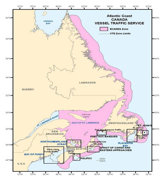
Figure 3-1 - Vessel Traffic Services - Atlantic Coast
REPLACE with to following chart
PART 4 - Page 56
AMEND
4.3.1.3 Information Updates
Notices to Mariners contain information which serves to correct charts and related publications. Up-to-date information
is available to vessels inbound for Canadian waters on any changes which have occurred between the date of issue of
the most recent monthly edition of Canadian Notices to Mariners held on board. Vessels wishing to avail themselves
of this service should send their request directly to ECAREG or NORDREG Canada. Requests may also be routed via any
MCTS Centre as listed in PART 2 of this document.
When making this request the following information shall be included:
- ship's name and call sign;
- present position, destination and intended route;
- most recent monthly edition of Canadian Notices to Mariners held on board; and
- list of recent Notices to Shipping held on board. Ice information, ice routing and icebreaker assistance may be obtained through the Eastern Canada Traffic System (ECAREG CANADA) or the Arctic Canada Traffic System (NORDREG CANADA). Refer to Notice Number 6 of the Annual Edition, Notices to Mariners or the publication "Ice Navigation in Canadian Waters" for additional information.
4.3.1.3 Information Updates
Notices to Mariners contain information which serves to correct charts and related publications. Up-to-date information is available to vessels inbound for Canadian waters on any changes which have occurred between the date of issue of the most recent monthly edition of Canadian Notices to Mariners held on board. Vessels wishing to avail themselves of this service should send their request directly to ECAREG or NORDREG Canada. Requests may also be routed via any MCTS Centre as listed in PART 2 of this document. When making this request the following information shall be included:
- ship's name and call sign;
- present position, destination and intended route;
- most recent monthly edition of Canadian Notices to Mariners held on board; and
- list of recent Notices to Shipping held on board. Ice information, ice routing and icebreaker assistance may be obtained through the Eastern Canada Traffic System (ECAREG CANADA) or the Northern Canada Vessel Traffic Services (NORDREG CANADA). Refer to Notice Number 6 of the Annual Edition, Notices to Mariners or the publication "Ice Navigation in Canadian
SAILING DIRECTIONS AND SAMLL CRAFT GUIDE CORRECTIONS
ATL 105 — Cape Canso to Cape Sable (including Sable Island), First Edition, 2001 —
Chapter 3 — Paragraph 71
Delete: twelve
Replace by: thirteen
(A2014-005.3)
ATL 106 — Gulf of Maine and Bay of Fundy, First Edition, 2001 —
Chapter 2 — Paragraph 79
Delete: “A fog signal … from this tower.”
(A2014-006.15)
ATL 108 — Gulf of St. Lawrence (Southwest Portion), First Edition, 2006 —
Chapter 3 — Paragraph 236, last line
Add: East Cardinal light buoy XVA (1119.2) is located 0.8 mile ESE of the light.
(A2014-008.11)
ATL 110 — St. Lawrence River — Cap Whittle/Cap Gaspé to Les Escoumins and Anticosti Island, Third Edition, 2011 —
Chapter 2 — Paragraph 123
Delete: 5.9
Replace by: 5.6
(Q2014-032.1)
Chapter 2 — Paragraph 125
Delete: (2007).
Replace by: (2014).
(Q2014-039.1)
Chapter 3 — Delete paragraph 154.1 and the adjacent caution pictograph.
(Q2014-054.1)
Chapter 3 — In the vicinity of paragraph 154, Table 3.4 Port of Matane Wharves
Make the following change in the “Depth” column.
| Berth | Depth metres |
| Public Wharf | |
| 1 | 9.7 |
(Q2014-054.2)
ATL 111 — St. Lawrence River — Île Verte to Québec and Fjord du Saguenay, Third Edition, 2007 —
Chapter 2 — In the vicinity of paragraph 4, Table 2.2 Summary of air obstructions for this booklet Make the following change in the “Overhead clearance (on nautical charts)” column.
| Location | Type | Overhead clearance (on nautical charts) |
| Pont de Québec | Bridge | Bridge / Bare cable 47 m |
(Q2014-037.1)
Chapter 2 — Paragraph 119
Delete: 46 m
Replace by: 47 m
(Q2014-037.2)
Chapter 2 — In the vicinity of paragraph 121, diagram PROFIL — PONT DE QUÉBEC — PROFILE
Replace the PROFIL — PONT DE QUÉBEC — PROFILE diagram with the new one provided in Section 4 of this Monthly Edition.
http://www.notmar.gc.ca/eng/services/notmar/pontdequebec20141106ed11e.pdf
(Q2014-037.3)
Chapter 2 — Paragraph 121
Delete: “where the vertical clearance … 231 m apart.”
Replace by: ; the two lights are 231 m apart. In the middle of the central span, for a width of 175 m , the vertical
clearance is 47 m.
(Q2014-037.4)
ATL 112 — St. Lawrence River — Cap-Rouge to Montréal and Rivière Richelieu, Third Edition, 2009 —
Chapter 2 — Paragraph 97
Delete: 0.8 and 1.7 m
Replace by: 1.1 and 2.2 m
(Q2014-031.1)
Chapter 2 — In the vicinity of paragraph 252, Table 2.4 Port of Montreal — Wharves (cont’d and end)
Make the following changes in the “Berth” and “Depth” columns.
| Berth | Depth metres |
| Valero | |
| 105 | 10.7 |
| 106 | 10.7 |
(Q2014-034.1)
CEN 308 — Rideau Canal and Ottawa River, First Edition, 2003 —
Chapter 8 — Paragraph 40
Delete: 27 m
Replace by: 23 m
(Q2014-042.1)
LIST OF LIGHTS, BUOYS AND FOG SIGNALS CORRECTIONS
Newfoundland |
||||||||||
133.3 |
Gimlet Point light buoy VG3 |
Little passage South side 47 37 55.1 55 54 05.3 |
Fl |
G |
4s |
..... |
..... |
Green spar, marked “VG3”. |
Year rouind Chart:4644 Edn 11/14 (N14-053) |
|
Atlantic |
||||||||||
1109 |
Shediac light buoy XN18 |
On N. side of turn in channel. 46 15 23.8 64 31 24.7 |
Q |
R |
1s |
..... |
..... |
Red spar, marked "XN18". |
Seasonal Chart:4909 Edn.11/14 (G14-185) |
|
1109.8 |
Shediac Harbour light buoy XN22 |
46 14 55.9 64 31 43.9 |
Fl |
R |
4s |
..... |
..... |
Red spar, marked "XN22". |
Seasonal. Chart:4909 Edn.11/14 (G14-186) |
|
1119.1 |
The Bluff East Cardinal light buoy XVB |
46 25 15.5 64 36 09.3 |
Q(3) |
W |
10s |
..... |
..... |
Black, yellow and black spar, marked "XVB". |
Seasonal. Buoy may be repositioned due to shifting channel. Chart:4909 Edn 11/14 (G14-150) |
|
1119.2 |
The Dune East Cardinal light buoy XVA |
46 27 23.2 64 35 41.5 |
VQ(3) |
W |
5s |
..... |
..... |
Black, yellow and black spar, marked "XVA". |
Seasonal. Buoy may be repositioned due to shifting channel. Chart:4909 Edn 11/14 (G14-151) |
|
1119.3 |
Buctouche Harbour light buoy XV10 |
46 27 21.2 64 38 12 |
Q |
R |
1s |
..... |
..... |
Red, marked "XV10". |
Seasonal. Buoy may be repositioned due to shifting channel. Chart:4909 Edn 11/14 (G14-158) |
|
1119.64 |
Buctouche Harbour light buoy XV4 |
46 27 08.3 64 36 33.2 |
Q |
R |
1s |
..... |
..... |
Red, marked "XV4". |
Seasonal. Buoy may be repositioned due to shifting channel. Chart: 4909 Edn 11/14 (G14-152) |
|
1119.65 |
Buctouche Harbour light buoy XV6 |
46 27 12.7 64 37 20.7 |
Fl |
R |
4s |
..... |
..... |
Red, marked "XV6". |
Seasonal. Buoy may be repositioned due to shifting channel. Chart: 4909 Edn 11/14 (G14-154) |
|
1119.7 |
Buctouche Harbour light buoy XV9 |
Delete from list. Chart: 4909 Edn 11/14 (G14-157) |
||||||||
1125.18 |
Buctouche Harbour light- buoy XV20 |
46 28 19.9 64 39 36.5 |
Fl |
R |
4s |
..... |
..... |
Red, marked "XV20" |
Seasonal. Buoy may be repositioned due to shifting channel Chart: 4909 Edn 11/14 (G14-165) |
|
1125.19 |
Buctouche Harbour light- buoy XV15 |
46 27 41.5 64 38 52.9 |
Fl |
G |
4s |
..... |
..... |
Green, marked "XV15" |
Seasonal. Buoy may be repositioned due to shifting channel Chart: 4909 Edn 11/14 (G14-159) |
|
1172.5 |
The Lump light buoy M6 |
47 06 27.8 64 58 10 |
Fl |
R |
4s |
..... |
..... |
Red spar, marked "M6". |
Seasonal. (In place Year round). Chart: 4911 Edn 11/14 (G14-168) |
|
1172.53 |
The Lump Light buoy M9 |
Delete from list Chart: 4911 Edn 11/14 (G14-170) |
||||||||
1172.6 |
The Lump light buoy M8 |
47 06 31.1 64 58 22.6 |
Q |
R |
1s |
..... |
..... |
Red spar, marked "M8". |
Seasonal. (In place Year round). Chart: 4911 Edn 11/14 (G14-169) |
|
1173 |
The Swashway Light buoy M10 |
47 06 55.1 64 58 41.8 |
Fl |
R |
4s |
..... |
..... |
Red marked "M10". |
Seasonal (In place Year round). Chart: 4911 Edn 11/14 (G14-171) |
|
1173.01 |
The Swashway light buoy M12 |
47 07 21.0 64 59 02.2 |
Fl |
R |
4s |
..... |
..... |
Red, marked "M12". |
Seasonal. (In place Year round). Chart: 4911 Edn 11/14 (G14-173) |
|
1173.3 |
Ship Channel – Light buoy M13 |
Delete from list. Chart: 4911 Édn 11/14 (G14-174) |
||||||||
1173.5 |
Miramichi Bar light buoy M14 |
47 07 46.6 64 59 22.6 |
Fl |
R |
4s |
..... |
..... |
Red spar, marked “M14”. |
Seasonal. (In place Year round.) Chart: 4911 Edn 11/14 (G14-176) |
|
1173.71 |
Miramichi Bar – Light buoy M15 |
47 08 08.7 64 59 50.2 |
Fl |
G |
4s |
..... |
..... |
Green spar marked “M15”. |
Seasonal. (In place Year round). Chart: 4911 Edn. 11/14 (G14-177) |
|
1173.8 |
Split Shoal light buoy M15/3 |
47 08 28.7 65 00 17.2 |
Q |
G |
1s |
..... |
..... |
Green, marked "M15/3". |
Seasonal. (In place Year round). Chart: 4911 Edn 11/14 (G14-179) |
|
1173.81 |
Split Shoal light buoy M16 |
47 08 29.0 65 00 06.3 |
Fl |
R |
4s |
..... |
..... |
Red spar, marked "M16". |
Seasonal. (In place Year round). Chart: 4911 Edn 11/14 (G14-178) |
|
1238.23 |
Tabusintac light buoy TA15 |
47 19 08.3 64 55 55.8 |
Fl |
G |
4s |
..... |
..... |
Green, spar marked "TA15". |
Seasonal. Chart: 4906 Edn 11/14 (G14-182) |
|
1319 |
Young Wharf |
On SE. corner of wharf. 47 47 48.9 64 55 31.3 |
Fl |
R |
5s |
7.5 |
9 |
Pipe swing pole. 7.1 |
Flash 0.2 s; eclipse 4.8 s. Operates at night only. Seasonal. Chart: 4920 Edn 11/14 (G14-172) |
|
1523 H1878 |
Pointe Ouest |
On W. extremity of island. 49 51 50.6 64 31 23.7 |
Fl |
W |
5s |
27.5 |
12 |
Skeleton tower. 19.8 |
Flash 1 s; eclipse 4 s. Operates at night only. Year round. Chart: 4430 Edn 11/14 (Q14-046) |
|
1580 H1922 1581 H1922.1 |
Aguanish range |
| | | | | | | | | | | |
E. side of entrance to rivière Aguanus. 50 13 05.8 62 05 00.4 330°29' 478.7m from front. |
F F |
G G |
..... ..... |
10.9 18.1 |
16 16 |
Square skeleton tower, orange daymark, black vertical stripe. 4.9 Square skeleton tower, orange daymark, black vertical stripe. 7.9 |
Visible in line of range. Operates at night only. Seasonal. Visible in line of range. Operates at night only. Seasonal. Chart: 4455 Edn 11/14 (Q14-035,036) |
Inland LL 2597 Inland LL 2597.1 |
Stic range |
| | | | | | | | | | | |
Koksoak river. Kuujjuaq 58 16 32.1 68 16 45.3 202°30' 285.8m from front. |
ISO ISO |
R R |
2s 2s |
18.3 28.6 |
14 14 |
Square skeleton tower, orange daymark, black vertical stripe. 14.2 Square skeleton tower, orange daymark, black vertical stripe. 9.4 |
Visible in line of range. Operates at night only. Seasonal. Visible in line of range. Operates at night only. Seasonal. Chart: 5338 Edn 11/14 (Q14-047,048) |
Inland LL 2597.2 Inland LL 2597.3 |
Tent range |
| | | | | | | | | | | |
West shore Koksoak river. Kuujjuaq 58 18 41.7 68 15 54.9 353° 21' 1468.5m from front. |
F F |
G G |
..... ..... |
24.3 61.3 |
16 16 |
Square skeleton tower, orange daymark, black vertical stripe. 15.5 Square skeleton tower, orange daymark, black vertical stripe. 9.4 |
Visible in line of range. Operates at night only. Seasonal. Visible in line of range. Operates at night only. Seasonal. Chart: 5338 Edn 11/14 (Q14-049,050) |
Inland LL 2597.4 Inland LL 2597.5 |
Chapel range |
| | | | | | | | | | | |
East shore Koksoak river. Kuujjuaq 58 12 27 68 17 13.1 195° 46' 1429.3m from front. |
F F |
G G |
..... ..... |
24.7 42.1 |
16 16 |
Square skeleton tower, orange daymark, black vertical stripe. 15.5 Square skeleton tower, orange daymark, black vertical stripe. 9.4 |
Visible in line of range. Operates at night only. Seasonal. Visible in line of range. Operates at night only. Seasonal. Chart: 5338 Edn 11/14 (Q14-051,052) |
Inland LL 2597.6 Inland LL 2597.7 |
Whale range |
| | | | | | | | | | | |
West shore Koksoak river. Kuujjuaq 58 11 10.6 68 19 35.2 209° 06' 1441.2m from front. |
F F |
R R |
..... ..... |
38.7 70 |
14 14 |
Square skeleton tower, orange daymark, black vertical stripe. 15.5 Square skeleton tower, orange daymark, black vertical stripe. 9.4 |
Visible in line of range. Operates at night only. Seasonal. Visible in line of range. Operates at night only. Seasonal. Chart: 5338 Edn 11/14 (Q14-053,054) |
Inland LL 2597.8 Inland LL 2597.9 |
Paint range |
| | | | | | | | | | | |
West shore Koksoak river. Kuujjuaq 58 14 19 68 18 28.4 359° 41' 1787.3m from front. |
ISO ISO |
G G |
2s 2s |
24.5 48.9 |
16 16 |
Square skeleton tower, orange daymark, black vertical stripe 15.6 Square skeleton tower, orange daymark, black vertical stripe. 9.4 |
Visible in line of range. Operates at night only. Seasonal. Visible in line of range. Operates at night only. Seasonal. Chart: 5338 Edn 11/14 (Q14-055,056) |
Inland |
||||||||||
766.4 766.45 766.5 |
Fort Gratiot front range(U.S.) Fort Gratiot range Passing light (U.S.) Fort Gratiot rear range(U.S.) |
| | | | | | | | | | | | | | | |
42 59 36.1 82 25 38.4 42 59 36.1 82 25 38.4 207°18' 193.5m from front. |
F F F |
G G G |
..... ..... ..... |
13 13 15.9 |
..... 9 ..... |
White cylindrical tower, red rectangular daymark, white vertical stripe. 13.4 White cylindrical tower, red rectangular daymark, white vertical stripe. 13.4 Octagonal tower, red rectangular daymark, white vertical stripe 17.7 |
Increased intensity on a bearing 326°. Year round. Year round. Year round. Chart: 14853(U.S.) Edn 11/14 (B14-018,019,020) |
1561 |
Red River Forks |
Delete from list. Chart: 6242 Edn 11/14 (A14-008) |
||||||||
1561.6 |
Red River Forks Light buoy X22 |
50 21 04.5 96 50 24.2 |
Fl |
R |
4s |
..... |
..... |
Red spar, marked X22 |
Seasonal. Chart: 6242 Edn 11/14(A14-009) |
|
1716.2 |
Mountain River |
Delete from list. Chart: 6341 Edn 11/14 (A14-023) |
||||||||
1716.5 |
Bigstone Point Islet |
Delete from list. Chart: 6341 Edn 11/14 (A14-024) |
||||||||
2597 2597.1 |
Stic range |
| | | | | | | | | | | |
Koksoak river. Kuujjuaq 58 16 32.1 68 16 45.3 202°30' 285.8m from front. |
ISO ISO |
R R |
2s 2s |
18.3 28.6 |
14 14 |
Square skeleton tower, orange daymark, black vertical stripe. 14.2 Square skeleton tower, orange daymark, black vertical stripe. 9.4 |
Visible in line of range. Operates at night only. Seasonal. Visible in line of range. Operates at night only. Seasonal. Chart: 5338 Edn 11/14 (Q14-047,048) |
2597.2 2597.3 |
Tent range |
| | | | | | | | | | | |
West shore Koksoak river. Kuujjuaq 58 18 41.7 68 15 54.9 353° 21' 1468.5m from front. |
F F |
G G |
..... ..... |
24.3 61.3 |
16 16 |
Square skeleton tower, orange daymark, black vertical stripe. 15.5 Square skeleton tower, orange daymark, black vertical stripe. 9.4 |
Visible in line of range. Operates at night only. Seasonal. Visible in line of range. Operates at night only. Seasonal. Chart: 5338 Edn 11/14 (Q14-049,050) |
2597.4 2597.5 |
Chapel range |
| | | | | | | | | | | |
East shore Koksoak river. Kuujjuaq 58 12 27 68 17 13.1 195° 46' 1429.3m from front. |
F F |
G G |
..... ..... |
24.7 42.1 |
16 16 |
Square skeleton tower, orange daymark, black vertical stripe. 15.5 Square skeleton tower, orange daymark, black vertical stripe. 9.4 |
Visible in line of range. Operates at night only. Seasonal. Visible in line of range. Operates at night only. Seasonal. Chart: 5338 Edn 11/14 (Q14-051,052) |
2597.6 2597.7 |
Whale range |
| | | | | | | | | | | |
West shore Koksoak river. Kuujjuaq 58 11 10.6 68 19 35.2 209° 06' 1441.2m from front. |
F F |
R R |
..... ..... |
38.7 70 |
14 14 |
Square skeleton tower, orange daymark, black vertical stripe. 15.5 Square skeleton tower, orange daymark, black vertical stripe. 9.4 |
Visible in line of range. Operates at night only. Seasonal. Visible in line of range. Operates at night only. Seasonal. Chart: 5338 Edn 11/14 (Q14-053,054) |
2597.8 2597.9 |
Paint range |
| | | | | | | | | | | |
West shore Koksoak river. Kuujjuaq 58 14 19 68 18 28.4 359° 41' 1787.3m from front. |
ISO ISO |
G G |
2s 2s |
24.5 48.9 |
16 16 |
Square skeleton tower, orange daymark, black vertical stripe 15.6 Square skeleton tower, orange daymark, black vertical stripe. 9.4 |
Visible in line of range. Operates at night only. Seasonal. Visible in line of range. Operates at night only. Seasonal. Chart: 5338 Edn 11/14 (Q14-055,056) |
|
CANADIAN COAST GUARD MARINE INFORMATION REPORT AND SUGGESTION SHEET. |
Name of Ship or Sender:..................................................................... Date:....................................
Address of Sender:..........................................................................................................................
Street # Street Name
Town / City:.............................. Prov / State:....................... Postal Code / Zip Code: ........................
Tel / Fax / E-mail address of sender (if appropriate):............................................................................
Observation Date:............................................. Time (UTC): ...........................................................
Geographical Position:......................................................................................................................
Coordinate Position: Lat: ............................................... Long:.........................................................
Position Method: q DGPS q GPS with WAAS q GPS q Radar qOther
Horizontal Datum Used: qWGS 84 q NAD 27 q Other
Estimated Position Accuracy:............................................................................................................
Chart #:............................................................ Datum: q NAD 27 q NAD 83
Chart Edition:.................................................... Last Correction applied:............................................
Publications affected: (Quote Volume and page):.................................................................................
*Full details (Attach additional sheets as necessary)............................................................................
Mariners are requested to notify the responsible authorities when new or suspected dangers to navigation are discovered, changes are observed in aids to navigation, or corrections to publications are seen to be necessary.
In the case of new or suspected dangers to navigation, it is important that all details be given in order to aid with future investigations. Items of interest include heights, depths, physical description, type of bottom and equipment method used to position the item. It is helpful to mark details on chart, which will be promptly replaced by the Canadian Hydrographic Service.
Reports should be made to the nearest Marine Communications and Traffic Services Centre (MCTS) and should be confirmed in writing to:
|
Leader, Notices to Mariners Canadian Coast Guard Department of Fisheries and Oceans Montréal, Qc H2Y 2E7 |
In the case of information concerning aids to navigation or the List of Lights, Buoys and Fog Signals. |
|
OR |
|
Dominion Hydrographer Canadian Hydrographic Service Department of Fisheries and Oceans Ottawa, Ontario, K1A 0E6 |
In the case of new or suspected dangers to navigation or where corrections to "Sailing Directions" appear to be necessary. |
Or general questions on Coast Guard programs or services please send an e-mail message to:
info@dfo-mpo.gc.ca (Please include your postal code and e-mail address).