
Archived information
The Standard on Web Usability replaces this content. This content is archived because Common Look and Feel 2.0 Standards have been rescinded.
Archived information is provided for reference, research or recordkeeping purposes. It is not subject to the Government of Canada Web Standards and has not been altered or updated since it was archived.
|
|
Fisheries and Oceans Canada |
Pêches et Ocèans Canada |
|
 |
|||
| MONTHLY EDITION N° 7 July 25th, 2014 |
|||
|
CONTENTS |
|||
Page |
|||
| Section 1 |
Safety and General Information | 1 - 9 |
|
| Section 2 |
Chart Corrections | 10 - 19 |
|
| Section 3 |
Radio Aids to Marine Navigation Corrections | N/A |
|
| Section 4 |
Sailing Directions and Small Craft Guide Corrections | 20 - 24 |
|
| Section 5 |
List of Lights, Buoys and Fog signals Corrections | 25 - 26 |
|
Maritime Services Directorate Aids to Navigation |
|||
Fisheries and Oceans Canada - Official publication of the Canadian Coast Guard |
|||

Geographical positions refer directly to the graduations of the largest scale Canadian Hydrographic chart unless otherwise indicated.
Bearings refer to the true compass and are measured clockwise from 000° (North) clockwise to 359°; those relating to lights are from seaward.
Visibility of lights is that in clear weather.
Depths - The units used for soundings (metres, fathoms or feet) are stated in the title of each chart.
Elevations are normally given above Higher High Water, Large Tides unless otherwise indicated.
Distances may be calculated as follows:
1 nautical mile = 1 852 metres (6,076.1 feet)
1 statute mile = 1 609.3 metres (5,280 feet)
1 metre = 3.28 feet
Temporary & Preliminary Notices are indicated by a (T) or a (P) before the chart action and in the section 1. Please note that Nautical charts are not amended by the Canadian Hydrographic Service for Temporary (T) and Preliminary (P) Notices. It is recommended that mariners chart these corrections in pencil. Listing of charts affected by Temporary and Preliminary Notices are revised and promulgated quarterly in Section 1 of the Monthly Edition.
Please note that, in addition to the temporary and preliminary changes normally advertised as (T) and (P) Notices, there are a few permanent changes to navigational aids that have been advertised as Preliminary Notices to Mariners while charts are being updated for new editions.
Marine Information Report & Suggestion Sheet - Mariners are requested to notify the responsible authorities when new or suspected dangers to navigation are discovered, changes observed in aids to navigation or corrections to publications are seen to be necessary. Such communications can be made using the Marine Information Report & Suggestion Sheet inserted on the last page of each monthly edition of Notices to Mariners.
Canadian Hydrographic Service - Information Published in Section 2 Notices to Mariners - Mariners are advised that only the most critical changes that directly affect safety to navigation are issued in Chart Corrections - Section 2. This limitation is required to ensure that charts remain as clear and easy to read as possible. As a result, mariners may see minor discrepancies of a non-critical nature between information in official publications. For example, a small change in the nominal range or height of a light may not result in the production of a chart correction, in Notices to Mariners, but may result in a List of Light, Buoys and Fog Signals correction.
In case of discrepancy between information provided on CHS charts related to aids to navigation, and the List of Light publication, the latter shall be deemed as containing the most up to date information
Canadian Nautical Charts & Publications - A source list of Canadian Nautical Charts & Publications is published in Notice No. 14 of the Notices to Mariners Annual Edition April 2011. The source supply and the prices effective at the time of printing are listed. For current chart edition dates refer to the following web site: http://www.chs-shc.gc.ca/charts-cartes/paper-papier/index-eng.asp
NOTE: Cette publication est aussi disponible en français.
Corrections to nautical charts will be listed in numeric order by chart number. Each chart correction listed applies only to that particular chart. Related charts, if any, will have their own specific correction listed separately.
Users should also refer to CHS Chart 1 Symbols, Abbreviations Terms for additional information pertaining to the correction of charts.
The illustration below describes the elements that will comprise a typical Section 2 chart correction.

MONTHLY EDITION OF NOTICES TO MARINERS
WEB ACCESS
We are offering a feature where subscribers to our on-line service are able to receive the complete electronic monthly edition of
our Notices to Mariners. We are encouraging our clients to visit the web site to subscribe for this service:
http://www.notmar.gc.ca/subscribe/
Users wishing to receive information updates for their charts can do so by setting up a ’User Profile’ on the following web page http://www.notmar.gc.ca/search/mycharts-eng.php?czoxOToibnRtPXN0ZXBfb25lJmxhbmc9ZSI7
This feature permits users to register the nautical charts they currently have in their possession. Registrants are then automatically notified by e-mail when a Notice to Mariners is published concerning these charts.
ADVISORY
NOTICES TO SHIPPING (WRITTEN AND BROADCAST)
The Canadian Coast Guard is implementing a number of changes to the aids to navigation system in Canada.
These changes are advertised as Notices to Shipping (Broadcast and Written) by the Canadian Coast Guard and are followed up with Notices to Mariners, then charts are updated by hand correction, reprints or new editions.
Mariners are advised that all relevant Written Notices to Shipping should be kept until superseded by Notices to Mariners or through revised charts issued by the Canadian Hydrographic Service.
Written Notices to Shipping are available on the Canadian Coast Guard Website at: www.ccg-gcc.gc.ca/eng/CCG/NOTSHIP.
The Canadian Hydrographic Service is reviewing the impact of these changes with the Canadian Coast Guard and together we are preparing an action plan on the issuing of chart revisions.
For further information contact your local Regional Notices to Shipping (NOTSHIP) issuing authorities.
|
Newfoundland |
Maritimes |
|
Quèbec |
Central & Arctic *Fisheries and Oceans Canada |
* Services provided in English and French
INDEX
| CANADIAN HYDROGRAPHIC SERVICE - ANNOUNCEMENT REGARDING CANADIAN HYDROGRAPHIC SERVICE CHART PATCHES | 1 |
| CANADIAN HYDROGRAPHIC SERVICE - CUMULATIVE CHART CORRECTIONS | 1 |
| CANADIAN HYDROGRAPHIC SERVICE - CURRENT CHART EDITION DATES | 1 |
| CANADIAN HYDROGRAPHIC SERVICE - PRINT ON DEMAND CHARTS - CARE AND USE | 1 |
| CANADIAN HYDROGRAPHIC SERVICE - TRANSPORT CANADA NAVIGATION SAFETY – ECDIS | 2 |
| CONSOLIDATION OF MARINE COMMUNICATIONS AND TRAFFIC SERVICES (MCTS) CENTRES | 2 |
| CANADIAN COAST GUARD PUBLICATION - RADIO AIDS TO MARINE NAVIGATION (ATLANTIC, ST. LAWRENCE, GREAT LAKES, LAKE WINNIPEG AND EASTERN ARCTIC) PUBLICATION – 2013 - THE COMMERCIAL PUBLIC CORRESPONDENCE SERVICE | 2 |
| ERRATUM: Reference Notice 604(P)/2014 | 3 |
| *701 SAGUENAY-ST. LAWRENCE MARINE PARK AND SURROUNDING WATERS - WHALE PROTECTION | 3 |
| *702 CANADIAN HYDROGRAPHIC SERVICE – NAUTICAL CHARTS | 5 |
| *703 CANADIAN HYDROGRAPHIC SERVICE – ELECTRIONIC NAVIGATIONAL CHARTS. | 5 |
| *704(P) FLINT ISLAND TO/À CAPE SMOKEY – FOG SIGNAL TO BE DISCONTINUED | 5 |
| *705(P) ANNAPOLIS BASIN – FOG SIGNAL TO BE DISCONTINUED. | 6 |
| *706(P) ANNAPOLIS BASIN – FOG SIGNAL TO BE DISCONTINUED | 6 |
| *707(P) ENTRÉE À/ENTRANCE TO MIRAMICHI RIVER – RANGE LIGHTS TO BE DISCONTINUED | 6 |
| *708(P) TRYON SHOALS TO/À CAPE EGMONT – LIGHT TO BE DISCONTINUED | 7 |
| *709(P) ANNAPOLIS BASIN – BUOYS TO BE AMENDED | 7 |
| *710(P) ANNAPOLIS BASIN – AID TO BE AMENDED | 8 |
| *711(P) ANNAPOLIS BASIN – FOG SIGNAL TO BE DISCONTINUED | 8 |
| *712(T) UPPER NIAGARA RIVER - GRAND ISLAND – BRIDGE MAINTENANCE WORK | 9 |
| *713 CANADIAN COAST GUARD - LIST OF CHARTS AND REFERENCE CHARTS (SECTION I) AFFECTED BY TEMPORARY AND PRELIMINARY NOTICES | 9 |
NUMERICAL INDEX OF CANADIAN CHARTS AFFECTED
| Chart No. | Page | Chart No. | Page | Chart No. | Page |
|
1220 |
10 |
4278 |
16 |
||
|
1234 |
10 |
4335 |
16,17 |
||
|
1236 |
10 |
4367 |
5 |
||
|
1310 |
11 |
4379 |
17 |
||
|
1311 |
11 |
4396 |
6,8 |
||
|
1312 |
12 |
4406 |
7 |
||
|
1314 |
12 |
4467 |
17 |
||
|
1350 |
13 |
4625 |
17 |
||
|
1360 |
5 |
4626 |
18 |
||
|
1361 |
5 |
4643 |
18 |
||
|
2006 |
13 |
4679 |
5 |
||
|
2018 |
13 |
4911 |
6,7 |
||
|
2028 |
13 |
5024 |
19 |
||
|
2064 |
14 |
5051 |
19 |
||
|
2100 |
14 |
6419 |
5 |
||
|
2120 |
14 |
6421 |
5 |
||
|
2123 |
14 |
6423 |
5 |
||
|
2250 |
5 |
6424 |
5 |
||
|
4015 |
15 |
6425 |
5 |
||
|
4016 |
15 |
6426 |
5 |
||
|
4047 |
15 |
6427 |
5 |
||
|
4130 |
5 |
14832 |
9 |
||
|
4141 |
15 |
SECTION 1
SAFETY AND GENERAL INFORMATION
CANADIAN HYDROGRAPHIC SERVICE - ANNOUNCEMENT REGARDING CANADIAN HYDROGRAPHIC SERVICE CHART PATCHES
Colour Web Patches are free to the mariner, and given the quality of many printers, should reproduce well. They will be available in real time all around the world.
CHS welcomes your feedback on this service at chsinfo@dfo-mpo.gc.ca .
CANADIAN HYDROGRAPHIC SERVICE - CUMULATIVE CHART CORRECTIONS
The cumulative Notices to Mariners corrections for charts can now be accessed at
www.notmar.gc.ca/search/notmar-eng.php .
CANADIAN HYDROGRAPHIC SERVICE - Current chart edition dates
CHART EDITIONS
The three terms described below are used to indicate the publication status of Canadian charts.
NEW CHART - "NEWCHT"
The first publication of a Canadian chart embracing an area not previously charted to the scale shown, or embracing an area different from any existing Canadian chart.
NEW EDITION - "NEWEDT"
A new issue of an existing chart containing amendments essential to navigation in addition to those issued in Notices to Mariners and making existing editions obsolete.
REPRINTS
A new issue of the current edition of a chart incorporating no amendments of navigational significance other than those
previously promulgated in Notices to Mariners. It may also contain amendments from other sources provided they
are not essential to navigation. Previous printings of the current edition remain in force.
The current chart edition dates can be accessed at
www.chs-shc.gc.ca/charts-cartes/paper-papier/index-eng.asp
CANADIAN HYDROGRAPHIC SERVICE - PRINT ON DEMAND CHARTS - CARE AND USE
Background
By providing nautical charts to the public, the goal of the Canadian Hydrographic Service (CHS) is to provide services for safe navigation in a fiscally responsible manner. As a result, CHS continues to expand its portfolio of nautical paper charts that are printed using Print On Demand (POD) technology. These charts are easily recognized by their whiter paper and the coloured logo of the Canadian Hydrographic Service. This new technology enables CHS to print charts in a more efficient manner while enhancing chart content through being able to quickly add new and important information. POD technology provides customers with up-to-date charts without the historical hand-drawn corrections or glued-on patches. Additionally, this technology eliminates out-of-stock situations which arise with the traditional printing and warehousing methods. In the event of a national emergency, CHS can respond to the appropriate authorities with best available information very quickly.
Care of Your POD Chart
CHS encourages its customers to handle the POD charts more carefully than the traditional lithographic charts. When plotting information on POD charts, use HB pencils and apply limited pressure. Testing has suggested that an Indian gum eraser is more effective than alternatives when used on the product. This eraser is also suitable for charts printed using lithographic processes.
CANADIAN HYDROGRAPHIC SERVICE - TRANSPORT CANADA NAVIGATION SAFETY - ECDIS
Mariners are advised that ECDIS may not display some isolated shoal depths when operating in "base or standard display" mode. Route planning and monitoring alarms for these shoal depths may not always be activated. To ensure safe navigation and to confirm that a planned route is clear of such dangers, mariners should visually inspect the planned route and any deviations from it using ECDIS configured to display "all data". The automated voyage planning check function should not be solely relied upon.
CONSOLIDATION OF MARINE COMMUNICATIONS AND TRAFFIC SERVICES (MCTS) CENTRES.
The Canadian Coast Guard is consolidating and modernizing its Marine Communications and Traffic Services.
These changes will result in a configuration of 12 MCTS Centres strategically located across the country.
Information pertaining to consolidation will be advertised to clients by all available means.
Atlantic Region
St. John’s MCTS will close; services will be provided remotely by Placentia MCTS
Saint John (Fundy) MCTS will close; services will be provided remotely by Halifax MCTS
St. Anthony MCTS will close; services will be provided remotely by Labrador (Goose Bay) MCTS
Central & Arctic Region
Montreal MCTS will close; services will be provided remotely by Quebec MCTS
Thunder Bay MCTS will close; services will be provided remotely by Sarnia MCTS
Rivière-au-Renard MCTS will close; services will be provided remotely by Les Escoumins MCTS
There will be no reduction in the MCTS level of service provided to clients. Mariners should be aware
that, as a result of consolidation, contact information, weather and other pertinent marine broadcast schedules
may change. These changes will be advertised in RAMN, as they become available.
Mariners should check NOTMAR PART 3 on a monthly basis for updates.
CANADIAN COAST GUARD PUBLICATION - RADIO AIDS TO MARINE NAVIGATION (ATLANTIC, ST. LAWRENCE, GREAT LAKES, LAKE WINNIPEG AND EASTERN ARCTIC) PUBLICATION - 2013 - The Commercial Public Correspondence Service.
Part I - Page 1 of 10
ADVANCE NOTICES
The Commercial Public Correspondence Service
Effective January 1, 2014, the following changes to the Canadian Coast Guard commercial public correspondence service, provided through select Marine Communications and Traffic Services centres, will be in effect: All long distance ship-shore calls will be administered through the regular telephone service provider as acollect call. Individuals intending to placeshore-ship calls will be required to direct-dial the appropriate MCTS centre. MCTS centres providing a commercial public correspondence service are identified in RAMN, Part 2.
ERRATUM: REFERENCE NOTICE 604(P)/2014
AMEND
Reference Chart: 4679
TO READ
Reference Chart: 4130
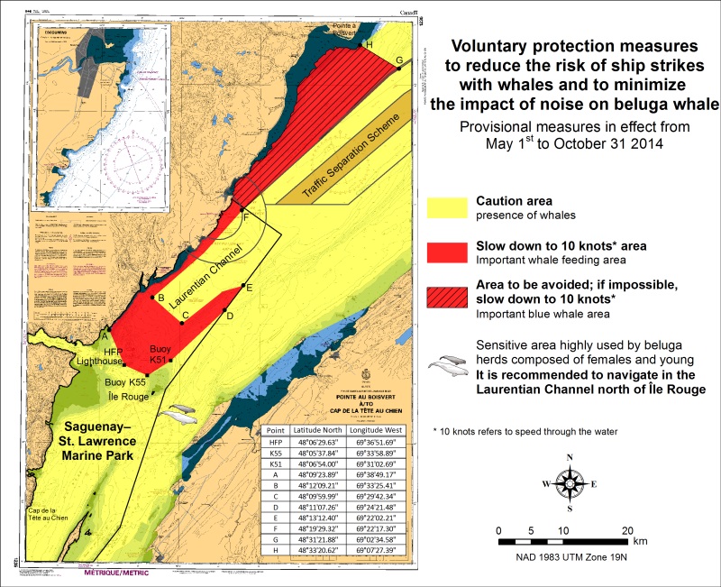
*701 SAGUENAY-ST. LAWRENCE MARINE PARK AND SURROUNDING WATERS - WHALE PROTECTION
The waters in and around the Saguenay-St. Lawrence Marine Park are well known for their resident threatened beluga population and the wide diversity of whales that migrate there to feed, particularly between April and November.
REGULATORY PROTECTION MEASURES
All whale species that are found in the St. Lawrence are protected under the Marine Mammal Regulations, pursuant to the Fisheries Act. Within the boundaries of the Marine Park, specific measures are set out in the Marine Activities in the Saguenay–St. Lawrence Marine Park Regulations, pursuant to the Act Establishing the Saguenay-St. Lawrence Marine Park. Any collision with a marine mammal within the Marine Park must immediately be reported to a park warden at 1-866-508-9888. For collisions that occur outside the Marine Park or for any situation involving a marine mammal that is dead or in trouble, contact the emergency network at 1-877-722-5346 or on channel 16. (see section 5C of the Annual Edition of the Notices to Mariners – April 2014 to March 2015).
VOLUNTARY PROTECTION MEASURES
Provisional measures in effect from May 1 to October 31, 2014
These measures apply to merchant vessels and cruise ships between Pointe à Boisvert and Cap de la Tête au Chien to prevent collisions with whales (see link below to view map). These measures should only be taken when they will not jeopardize navigational safety.
Caution area (yellow area): To reduce the risk of collisions with whales that can be present anywhere in this area, heightened vigilance is critical for navigators. Posting a lookout is recommended in order to increase the chances of seeing the whales and thus taking necessary measures to avoid them. If bypassing the whales is not possible, slow down and wait for the animals to move away to a distance greater than 400 meters (0.215 nautical miles) before resuming original speed. It is more difficult to see the animals at night therefore increased caution is recommended. Slow down to 10 knots area (red area): To reduce the risk of collisions with whales in this feeding area, it is recommended that vessels slow down to a maximum speed through the water of 10 knots and post a lookout. It is further recommended to remain in the Laurentian Channel to the north of île Rouge to minimize the impact of noise in a sensitive area south of this island, which is highly frequented by herds of beluga whales composed of females and young.
Area to be avoided (hatched red area): To reduce noise and the risk of collisions with whales, vessels should avoid transiting through this area which is highly frequented by blue whales, an endangered species. If the area cannot be avoided, slow down to a maximum speed through the water of 10 knots.
See attached map:
*702 CANADIAN HYDROGRAPHIC SERVICE - NAUTICAL CHARTS.
|
CHARTS |
MAIN TITLE |
SCALE |
PUBLISHED |
CAT# |
PRICE |
|
New Charts |
|||||
|
1360 |
Lac Memphrémagog |
1:30000 |
23-MAY-2014 |
||
|
New Editions |
|||||
|
2250 |
Bruce Mines to/à Sugar Island |
1:25000 |
28-FEB-2014 |
3 |
20.00 |
|
6419 |
Norman Wells to/à Carcajou Ridge Kilometre 910 / Kilomètre 980 |
1:50000 |
21-MAR-2014 |
4 |
12.00 |
|
6421 |
Hardie Island to/à Fort Good Hope Kilometre 1040 / Kilometre 1100 |
1:50000 |
21-MAR-2014 |
4 |
12.00 |
|
6423 |
Askew Islands to/à Bryan Island Kilometre 1180 / Kilometre 1240 |
1:50000 |
21-MAR-2014 |
4 |
12.00 |
|
6424 |
Bryan Island to/à Travaillant River Kilometre 1240 / Kilomètre 1325 |
1:50000 |
21-MAR-2014 |
4 |
12.00 |
|
6425 |
Travaillant River to/à Adam Cabin Creek Kilometre 1325 / Kilomètre 1400 |
1:50000 |
21-MAR-2014 |
4 |
12.00 |
|
6426 |
Adam Cabin Creek to/à Point Separation Kilometre 1400 / Kilomètre 1480 |
1:50000 |
21-MAR-2014 |
4 |
12.00 |
|
6427 |
Point Separation to/au Aklavik Channel Kilometre 1480 / Kilomètre 1540 |
1:50000 |
21-MAR-2014 |
4 |
12.00 |
|
Charts Permanently Withdrawn |
|||||
|
1361 |
Lac Memphrémagog |
||||
>*703 CANADIAN HYDROGRAPHIC SERVICE - electrionic navigational CHARTS.
|
NEW PRODUCTS |
|
|
S-57 ENC NUMBER |
CHART TITLE |
|
CA376316 |
Fortune Bay Northern Portion/Partie Nord |
|
CA479239 |
Lac Memphrémagog A-B |
|
CA479240 |
Lac Memphrémagog B-C |
|
CA579241 |
Magog |
*704(P) Flint Island to/à Cape Smokey - Fog Signal to be discontinued.
Reference Chart: 4367
The Canadian Coast Guard proposes to permanently discontinue the following Aid to navigation:
The Fog Signal on Flint Island light, LL 770 (46° 10' 51"N 59° 46' 16.2"W).
Comments on this action are solicited from mariners and other interested parties.
Comments should be directed to the following within three months from the date of this notice:
A\Regional Superintendent,
Aids to Navigation & Waterways,
Canadian Coast Guard,
PO Box 5667,
St. John's, NL, A1C 5X1
Telephone: 709-772-5195,
Email: Renee.Pope@dfo-mpo.gc.ca
Any objections raised must state the facts on which they are based and should include supporting information
on safety, commerce and public benefit.
(G2014-038)
*705(P) Annapolis Basin - Fog Signal to be discontinued.
Reference Chart: 4396
The Canadian Coast Guard proposes to permanently discontinue the following Aid to navigation:
The Fog Signal on Prim Point light, LL 201 (44° 41' 28"N 65° 47' 10.8"W).
Comments on this action are solicited from mariners and other interested parties.
Comments should be directed to the following within three months from the date of this notice:
A\Regional Superintendent,
Aids to Navigation & Waterways,
Canadian Coast Guard,
PO Box 5667,
St. John's, NL, A1C 5X1
Telephone: 709-772-5195,
Email: Renee.Pope@dfo-mpo.gc.ca
Any objections raised must state the facts on which they are based and should include supporting information
on safety, commerce and public benefit.
(F2014-018)
*706(P) Annapolis Basin - Fog Signal to be discontinued.
Reference Chart: 4396
The Canadian Coast Guard proposes to permanently discontinue the following Aid to navigation:
The Fog Signal on Port Wade light, LL 209 (44° 40' 33.9"N 65° 42' 41.1"W).
Comments on this action are solicited from mariners and other interested parties.
Comments should be directed to the following within three months from the date of this notice:
A\Regional Superintendent,
Aids to Navigation & Waterways,
Canadian Coast Guard,
PO Box 5667,
St. John's, NL, A1C 5X1
Telephone: 709-772-5195,
Email: Renee.Pope@dfo-mpo.gc.ca
Any objections raised must state the facts on which they are based and should include supporting information
on safety, commerce and public benefit.
(F2014-020)
*707(P) Entrée à/Entrance to Miramichi River - range lights to be discontinued.
Reference Chart:4911
The Canadian Coast Guard proposes to permanently discontinue the following Aids to navigation:
Preston Beach West Range lights LL 1173.15, 1173.16 (47° 04' 01"N 64° 56' 31.5"W) Aprox.
Comments on this action are solicited from mariners and other interested parties.
Comments should be directed to the following within three months from the date of this notice:
A\Regional Superintendent,
Aids to Navigation & Waterways,
Canadian Coast Guard,
PO Box 5667,
St. John's, NL, A1C 5X1
Telephone: 709-772-5195,
Email: Renee.Pope@dfo-mpo.gc.ca
Any objections raised must state the facts on which they are based and should include supporting information
on safety, commerce and public benefit.
(G2014-036, 037)
*708(P) Tryon Shoals to/à Cape Egmont - LIGHT TO BE DISCONTINUED.
Reference Chart: 4406
The Canadian Coast Guard proposes to permanently discontinue the following Aid to navigation:
Fort Monckton Point light, LL 1086 (46° 02' 35.5"N 64° 04' 13.9"W).
Comments on this action are solicited from mariners and other interested parties.
Comments should be directed to the following within three months from the date of this notice:
A\Regional Superintendent,
Aids to Navigation & Waterways,
Canadian Coast Guard,
PO Box 5667,
St. John's, NL, A1C 5X1
Telephone: 709-772-5195,
Email: Renee.Pope@dfo-mpo.gc.ca
Any objections raised must state the facts on which they are based and should include supporting information
on safety, commerce and public benefit.
(G2014-031)
*709(P) Annapolis Basin - Buoys to be AmEnded.
Reference Chart: 4396
The Canadian Coast Guard proposes to permanently amend the following Aids to navigation:
A green light Fl 0.5s;Ec 3.5s will be added to Port Wade green buoy VE1 and it will be reposition from 44° 40′ 05.3′′N 65° 41′ 26.8′′W to 44° 39′ 36.1′′N 65° 42′ 05.7′′W.
Clementsport red spar buoy VE2, will be repositioned from 44° 40′ 32.37′′N 65° 38′ 57.8′′W to 44° 40′ 01.4′′N 65° 40′ 13.4′′W approx.
Comments on this action are solicited from Mariners and other interested parties.
Comments should be directed to the following within three months from the date of this notice:
A/Superintendent Aids & Waterways,
Canadian Coast Guard,
P.O. Box 5667,
St. John's, NL, A1C 5X1
Phone: 709-772-5195.
Email: Renee.Pope@dfo-mpo.gc.ca
Any objections raised must state the facts on which they are based and should include supporting information
on safety, commerce and public benefit.
(F2014-022)
*710(P) Annapolis Basin -LIGHT to be Amended.
Reference Chart: 4396
The Canadian Coast Guard proposes to permanently amend the following Aids to navigation:
Existing structure of Digby Gut light, LL 202 (44° 47′ 17.1′′N 65° 45′ 34.6′′W) will be replaced by a steel tower equipped with a green lantern Fl 2s Ec 4s.
Comments on this action are solicited from Mariners and other interested parties.
Comments should be directed to the following within three months from the date of this notice:
A/Superintendent Aids & Waterways,
Canadian Coast Guard,
P.O. Box 5667,
St. John's, NL, A1C 5X1
Phone: 709-772-5195.
Email: Renee.Pope@dfo-mpo.gc.ca
Any objections raised must state the facts on which they are based and should include supporting information
on safety, commerce and public benefit.
(F2014-021)
*711(P) Annapolis Basin - Fog Signal to be discontinued.
Reference Chart: 4396
The Canadian Coast Guard proposes to permanently discontinue the following Aid to navigation:
The Fog Signal on Digby Gut light, LL 202 (44° 47′ 17.1′′N 65° 45′ 34.6′′W).
Comments on this action are solicited from mariners and other interested parties.
Comments should be directed to the following within three months from the date of this notice:
A\Regional Superintendent,
Aids to Navigation & Waterways,
Canadian Coast Guard,
PO Box 5667,
St. John's, NL, A1C 5X1
Telephone: 709-772-5195,
Email: Renee.Pope@dfo-mpo.gc.ca
Any objections raised must state the facts on which they are based and should include supporting information
on safety, commerce and public benefit.
(F2014-019)
*712(T) UPPER NIAGARA RIVER - GRAND ISLAND - BRIDGE MAINTENANCE WORK.
Reference: U.S. Chart. 14832
Maintenance work is being performed on North Grand Island Bridge at Mile 18.0 over the Niagara River from April 01, 2014 until approximately November 20, 2015. Six barges 18 metres by 18 metres marked with 24hrs Red lights are on site close to the bridge piers. At night and when not in use barges will be moored outside of the navigation channel. Mariners are requested to reduce speed in the area.
(NOTSHIP C325/14)
*713 CANADIAN COAST GUARD - LIST OF CHARTS AND REFERENCE CHARTS (SECTION I) AFFECTED BY TEMPORARY AND PRELIMINARY NOTICES.
IN EFFECT JUNE 27, 2014
(REVISED AND PROMULGATED QUARTERLY)
|
2305 |
1204(P)/08 |
|
4010 |
605(P)/14 |
|
4124 |
307(P)/14 |
|
4130 |
604(P)/14 |
|
4201 |
509(P) /13 |
|
4233 |
210(P)/12 |
|
4243 |
308(P)/14 |
|
4266 |
608(P)/12, 609(P)/12, 420(P)/14 |
|
4279 |
1210(P)/13 |
|
4281 |
1111(P)/11 |
|
4340 |
305(P) /14; 306(P) /14, 418(P)/14 |
|
4367 |
508(P)/14 |
|
4377 |
405(P)/13 |
|
4386 |
1108(P)/13, 507(P)/14 |
|
4396 |
510(P)/13 |
|
4449 |
1211(P)/13; 106(P)/14 |
|
4450 |
1005(P)/13; 1006(P)/13 |
|
4466 |
109(P)/14 |
|
4512 |
1205(P) /13 |
|
4522 |
1103(T) /13; 1207(T) /13; |
|
4596 |
1209(T) /13; |
|
4670 |
1206(T) /13; |
|
4679 |
603(P)/14 |
|
4830 |
1104(T) /13; |
|
4905 |
204(P) /14 |
|
4909 |
613(P)/12, 810(P)/12; 205(P) /14; 206 (P) /14; 207(P) /14; 304(P) /14, 421(P)/14 |
|
4911 |
811(P)/12, 612(P)/13 |
|
4921 |
713(P)/13 |
|
5051 |
1208(T) /13; |
|
6267 |
112(P)/06 |
|
US14884 |
715(T)/13 |
1220 - Sept-Îles - New Edition - 11-MAY-2012 - NAD 1983
|
11-JUL-2014 |
LNM/D. 16-MAY-2014 |
||
|
Add |
depth of 14 metres 6 decimetres |
50°10′38.9″N 066°22′19.4″W |
|
|
DFO(6408935-01) |
|||
1234 - Port de Pointe-au-Pic - New Edition - 04-NOV-2011 - NAD 1983
|
04-JUL-2014 |
LNM/D. 29-JUN-2012 |
||
|
Delete |
depth of 8 metres 2 decimetres |
47°37′19.5″N 070°08′24.6″W |
|
|
This notice affects Electronic Navigational Chart: CA579032 |
|||
|
DFO(6408924-01) |
|||
|
Delete |
depth of 8 metres 2 decimetres |
47°37′20.6″N 070°08′23.1″W |
|
|
This notice affects Electronic Navigational Chart: CA579032 |
|||
|
DFO(6408924-02) |
|||
|
Add |
depth of 7 metres 8 decimetres |
47°37′19.0″N 070°08′25.4″W |
|
|
This notice affects Electronic Navigational Chart: CA579032 |
|||
|
DFO(6408924-03) |
|||
|
Add |
depth of 7 metres 6 decimetres |
47°37′19.9″N 070°08′23.6″W |
|
|
This notice affects Electronic Navigational Chart: CA579032 |
|||
|
DFO(6408924-04) |
|||
|
Delete |
depth of 7 metres 9 decimetres |
47°37′18.2″N 070°08′26.6″W |
|
|
This notice affects Electronic Navigational Chart: CA579032 |
|||
|
DFO(6408924-05) |
|||
|
Add |
depth of 7 metres 7 decimetres |
47°37′18.1″N 070°08′26.7″W |
|
|
This notice affects Electronic Navigational Chart: CA579032 |
|||
|
DFO(6408924-06) |
|||
1236 - Pointe des Monts aux/to Escoumins - New Edition - 26-OCT-2012 - NAD 1983
|
11-JUL-2014 |
LNM/D. 14-MAR-2014 |
||
|
Replace |
wreck Wk with known depth of 19 metres 4 decimetres by wreck Wk with known depth of 19 metres 1 decimetre |
48°36′28.8″N 068°25′43.0″W |
|
|
This notice affects Electronic Navigational Chart: CA279037 |
|||
|
DFO(6408921-01) |
|||
1310 - Section A-B - New Edition - 10-JAN-2014 - NAD 1983
|
18-JUL-2014 |
LNM/D. 02-MAY-2014 |
||
|
Add |
depth of 9 metres 9 decimetres |
45°42′32.4″N 073°26′08.9″W |
|
|
This notice affects Electronic Navigational Chart: CA579001 |
|||
|
DFO(6408929-05) |
|||
|
Delete |
depth of 10 metres 8 decimetres |
45°42′46.9″N 073°26′01.0″W |
|
|
This notice affects Electronic Navigational Chart: CA579001 |
|||
|
DFO(6408929-06) |
|||
|
Add |
depth of 9 metres 5 decimetres |
45°42′47.1″N 073°26′00.5″W |
|
|
This notice affects Electronic Navigational Chart: CA579001 |
|||
|
DFO(6408929-07) |
|||
1311 - Sorel-Tracy à/to Varennes - New Edition - 19-SEP-2013 - NAD 1983
|
18-JUL-2014 |
LNM/D. 11-JUL-2014 |
||
|
Delete |
depth of 13 metres 1 decimetre |
46°02′41.3″N 073°09′29.6″W |
|
|
This notice affects Electronic Navigational Chart: CA479129 |
|||
|
DFO(6408929-01) |
|||
|
Add |
depth of 12 metres 3 decimetres |
46°02′40.1″N 073°09′29.8″W |
|
|
This notice affects Electronic Navigational Chart: CA479129 |
|||
|
DFO(6408929-02) |
|||
|
Delete |
depth of 11 metres 7 decimetres |
46°02′26.2″N 073°09′32.0″W |
|
|
This notice affects Electronic Navigational Chart: CA479129 |
|||
|
DFO(6408929-03) |
|||
|
Add |
depth of 11 metres 6 decimetres |
46°02′26.2″N 073°09′32.0″W |
|
|
This notice affects Electronic Navigational Chart: CA479129 |
|||
|
DFO(6408929-04) |
|||
|
11-JUL-2014 |
|||
|
Replace |
red starboard hand lighted spar buoy Fl R, marked MQ32 with red starboard hand lighted pillar buoy Fl R, marked MQ32 |
45°50′55.6″N 073°16′00.9″W |
|
|
This notice affects Electronic Navigational Chart: CA479155 |
|||
|
(Q2014016) LL(2313.4) DFO(6408897-01) |
|||
1312 - Lac Saint-Pierre - New Edition - 24-MAY-2013 - NAD 1983
|
18-JUL-2014 |
LNM/D. 06-JUN-2014 |
||
|
Delete |
depth of 13 metres 1 decimetre |
46°02′41.3″N 073°09′29.6″W |
|
|
This notice affects Electronic Navigational Chart: CA479129 |
|||
|
DFO(6408929-01) |
|||
|
Add |
depth of 12 metres 3 decimetres |
46°02′40.1″N 073°09′29.8″W |
|
|
This notice affects Electronic Navigational Chart: CA479129 |
|||
|
DFO(6408929-02) |
|||
|
Delete |
depth of 11 metres 7 decimetres |
46°02′26.2″N 073°09′32.0″W |
|
|
This notice affects Electronic Navigational Chart: CA479129 |
|||
|
DFO(6408929-03) |
|||
|
Add |
depth of 11 metres 6 decimetres |
46°02′26.2″N 073°09′32.0″W |
|
|
This notice affects Electronic Navigational Chart: CA479129 |
|||
|
DFO(6408929-04) |
|||
1312 - Port de Sorel-Tracy - New Edition - 24-MAY-2013 - NAD 1983
|
18-JUL-2014 |
LNM/D. 06-JUN-2014 |
||
|
Delete |
depth of 1 metre 9 decimetres |
46°03′00.1″N 073°05′34.7″W |
|
|
This notice affects Electronic Navigational Chart: CA579130 |
|||
|
DFO(6408917-01) |
|||
|
Add |
depth of 1 metre 4 decimetres |
46°03′00.6″N 073°05′34.3″W |
|
|
This notice affects Electronic Navigational Chart: CA579130 |
|||
|
DFO(6408917-02) |
|||
1314 - Portneuf - New Edition - 21-JUN-2013 - NAD 1983
|
04-JUL-2014 |
|||
|
Add |
Ru against wharf |
46°40′52.0″N 071°52′37.7″W |
|
|
This notice affects Electronic Navigational Chart: CA579019 |
|||
|
DFO(6408926-01) |
|||
1350 - Sorel-Tracy - Sheet/Feuille 1 - New Edition - 15-DEC-2006 - NAD 1983
|
18-JUL-2014 |
LNM/D. 27-JUN-2014 |
||
|
Delete |
depth of 1 metre 9 decimetres |
46°03′00.1″N 073°05′34.7″W |
|
|
This notice affects Electronic Navigational Chart: CA579130 |
|||
|
DFO(6408917-01) |
|||
|
Add |
depth of 1 metre 4 decimetres |
46°03′00.6″N 073°05′34.3″W |
|
|
This notice affects Electronic Navigational Chart: CA579130 |
|||
|
DFO(6408917-02) |
|||
2006 - Upper Gap to/à Telegraph Narrows - New Edition - 31-MAR-2000 - NAD 1983
|
18-JUL-2014 |
LNM/D. 31-MAY-2013 |
||
|
Add |
wreck WK with known depth of 75 feet |
44°08′51.6″N 076°47′37.2″W |
|
|
This notice affects Electronic Navigational Chart: CA373063, CA473276 |
|||
|
DFO(6603983-01) |
|||
|
Delete |
sounding of 72 feet |
44°08′52.5″N 076°47′36.5″W |
|
|
DFO(6603983-04) |
|||
2018 - Lower Gap to/à Adolphus Reach - New Chart - 22-JUN-1990 - NAD 1983
|
18-JUL-2014 |
LNM/D. 27-JUN-2014 |
||
|
Add |
wreck WK with known depth of 22.9 metres |
44°08′51.6″N 076°47′37.2″W |
|
|
This notice affects Electronic Navigational Chart: CA373063, CA473276 |
|||
|
DFO(6603983-01) |
|||
|
Add |
wreck WK with known depth of 30.5 metres |
44°04′33.5″N 076°44′04.1″W |
|
|
This notice affects Electronic Navigational Chart: CA373063, CA473276 |
|||
|
DFO(6603983-02) |
|||
2028 - Continuation A - Sheet/Feuille 1 - New Edition - 15-JUN-2007 - NAD 1983
|
11-JUL-2014 |
LNM/D. 29-OCT-2010 |
||
|
Add |
wreck WK with known depth of 12.2 metres |
44°22′39.6″N 079°41′12.2″W |
|
|
DFO(6603984-01) |
|||
2064 - Kingston to/à False Duck Islands - New Edition - 05-MAR-1999 - NAD 1983
|
18-JUL-2014 |
LNM/D. 27-JUN-2014 |
||
|
Add |
wreck WK with known depth of 12 fathoms |
44°08′51.6″N 076°47′37.2″W |
|
|
This notice affects Electronic Navigational Chart: CA373063, CA473276 |
|||
|
DFO(6603983-01) |
|||
|
Add |
wreck WK with known depth of 16 fathoms |
44°04′33.5″N 076°44′04.1″W |
|
|
This notice affects Electronic Navigational Chart: CA373063, CA473276 |
|||
|
DFO(6603983-02) |
|||
2100 - Lake Erie / Lac Érié - New Edition - 25-DEC-1998 - NAD 1983
|
25-JUL-2014 |
LNM/D. 15-NOV-2013 |
||
|
Delete |
red and white fairway lighted pillar bell buoy Mo(A). |
42°50′08.9″N 078°55′25.4″W |
|
|
This notice affects Electronic Navigational Chart: CA273094, CA373093 |
|||
|
DFO(6603987-01) |
|||
2120 - Niagara River to/à Long Point - New Edition - 15-APR-2005 - NAD 1983
|
25-JUL-2014 |
LNM/D. 27-JUN-2014 |
||
|
Delete |
red and white fairway lighted pillar bell buoy Mo(A), marked B. |
42°50′08.9″N 078°55′25.4″W |
|
|
This notice affects Electronic Navigational Chart: CA273094, CA373093 |
|||
|
DFO(6603987-01) |
|||
|
Delete |
red starboard hand lighted pillar buoy Fl R, marked 2. |
42°29′49.1″N 079°21′04.5″W |
|
|
This notice affects Electronic Navigational Chart: CA373093 |
|||
|
(USCG:LNM 20/14) DFO(6603988-01) |
|||
2123 - Pelee Passage to/à la Detroit River - New Edition - 27-JAN-2006 - NAD 1983
|
25-JUL-2014 |
LNM/D. 09-NOV-2012 |
||
|
Delete |
red and white lighted fairway pillar buoy, and text ″Mo(A)″ |
41°50′08.0″N 083°10′11.0″W |
|
|
This notice affects Electronic Navigational Chart: CA373089 |
|||
|
(USCG:LNM 20/14) DFO(6603985-01) |
|||
|
Amend |
Fl(2) 5s 11m to read Fl(2)R 5s 11m against light |
41°52′04.0″N 083°22′36.0″W |
|
|
This notice affects Electronic Navigational Chart: CA373089 |
|||
|
(USCG:LNM 19/14) DFO(6603986-01) |
|||
4015 - Sydney to/à Saint-Pierre - New Edition - 28-MAR-2003 - NAD 1983
|
25-JUL-2014 |
LNM/D. 07-FEB-2014 |
||
|
Add |
wreck, least depth unknown |
46°49′38.4″N 056°05′09.0″W |
|
|
This notice affects Electronic Navigational Chart: CA276091, CA376164 |
|||
|
DFO(6306742-01) |
|||
|
Add |
wreck, least depth unknown |
46°49′19.4″N 056°06′49.3″W |
|
|
This notice affects Electronic Navigational Chart: CA276091, CA376164 |
|||
|
DFO(6306742-02) |
|||
4016 - Saint-Pierre to/à St. John's - New Edition - 06-JUN-2003 - NAD 1983
|
25-JUL-2014 |
LNM/D. 25-APR-2014 |
||
|
Add |
wreck, least depth unknown |
46°49′38.4″N 056°05′09.0″W |
|
|
This notice affects Electronic Navigational Chart: CA276091, CA376164 |
|||
|
DFO(6306742-01) |
|||
|
Add |
wreck, least depth unknown |
46°49′19.4″N 056°06′49.3″W |
|
|
This notice affects Electronic Navigational Chart: CA276091, CA376164 |
|||
|
DFO(6306742-02) |
|||
4047 - St. Pierre Bank/Banc de Saint-Pierre to/au Whale Bank/Banc de la Baleine - New Edition - 09-OCT-1998 - NAD 1983
|
25-JUL-2014 |
LNM/D. 25-APR-2014 |
||
|
Add |
wreck, least depth unknown |
46°49′38.4″N 056°05′09.0″W |
|
|
This notice affects Electronic Navigational Chart: CA276091, CA376164 |
|||
|
DFO(6306742-01) |
|||
|
Add |
wreck, least depth unknown |
46°49′19.4″N 056°06′49.3″W |
|
|
This notice affects Electronic Navigational Chart: CA276091, CA376164 |
|||
|
DFO(6306742-02) |
|||
4141 - Saint John to/à Grand Bay including/y compris Kennebecasis River - Sheet/Feuille 1 - New Edition - 30-OCT-2009 - NAD 1983
|
25-JUL-2014 |
LNM/D. 30-NOV-2012 |
||
|
Reposition |
yellow cautionary spar buoy, marked AA |
from 45°25′34.5″N 066°01′36.0″W |
|
|
to 45°25′32.8″N 066°01′39.5″W |
|||
|
(F2014016) DFO(6306758-01) |
|||
4278 - Great Bras D'Or and/et St. Patricks Channel - New Edition - 20-MAR-1998 - NAD 1983
|
04-JUL-2014 |
LNM/D. 27-JUN-2014 |
||
|
Add |
depth of 4 metres, 1 decimetre |
46°02′53.9″N 060°50′55.9″W |
|
|
This notice affects Electronic Navigational Chart: CA476141 |
|||
|
DFO(6306731-01) |
|||
|
Add |
depth of 9 metres, 4 decimetres |
46°04′56.0″N 060°46′43.7″W |
|
|
This notice affects Electronic Navigational Chart: CA476141 |
|||
|
DFO(6306731-02) |
|||
|
Delete |
depth of 6 metres, 4 decimetres |
46°04′58.0″N 060°46′32.4″W |
|
|
This notice affects Electronic Navigational Chart: CA476141 |
|||
|
DFO(6306731-03) |
|||
|
Add |
depth of 4 metres |
46°04′58.9″N 060°46′35.6″W |
|
|
This notice affects Electronic Navigational Chart: CA476141 |
|||
|
DFO(6306731-04) |
|||
|
Replace |
depth of 24 metres with depth of 21 metres, 8 decimetres |
46°05′19.0″N 060°43′03.7″W |
|
|
This notice affects Electronic Navigational Chart: CA476141 |
|||
|
DFO(6306731-05) |
|||
|
Add |
depth of 45 metres |
46°05′02.2″N 060°40′52.2″W |
|
|
This notice affects Electronic Navigational Chart: CA476141 |
|||
|
DFO(6306731-06) |
|||
|
Replace |
depth of 24 metres with depth of 21 metres, 9 decimetres |
46°05′57.4″N 060°40′44.2″W |
|
|
This notice affects Electronic Navigational Chart: CA476141 |
|||
|
DFO(6306731-07) |
|||
|
Add |
depth of 1 metre, 3 decimetres |
46°07′26.6″N 060°42′05.7″W |
|
|
This notice affects Electronic Navigational Chart: CA476141 |
|||
|
DFO(6306731-08) |
|||
4335 - Guysborough Harbour - New Edition - 04-JAN-2008 - NAD 1983
|
18-JUL-2014 |
LNM/D. 07-FEB-2014 |
||
|
Replace |
Red Starboard lighted Pillar buoy FlR, marked CQ2 with Red Starboard lighted Conical buoy FlR, marked CQ2. |
45°22′33.2″N 061°29′13.3″W |
|
|
(G2014035) LL(683.1) DFO(6306741-01) |
|||
4335 - Strait of Canso and Approaches/et les approches - New Edition - 04-JAN-2008 - NAD 1983
|
18-JUL-2014 |
LNM/D. 07-FEB-2014 |
||
|
Replace |
Red Starboard lighted Pillar buoy FlR, marked CQ2 with Red Starboard lighted Conical buoy FlR, marked CQ2. |
45°22′33.2″N 061°29′13.3″W |
|
|
(G2014035) LL(683.1) DFO(6306741-01) |
|||
4379 - Liverpool Harbour - New Edition - 18-JUL-2003 - NAD 1983
|
25-JUL-2014 |
LNM/D. 05-JUL-2013 |
||
|
Add |
depth of 9 feet |
44°02′41.4″N 064°42′34.9″W |
|
|
DFO(6306754-01) |
|||
4467 - Rustico Bay - New Edition - 10-JAN-2003 - NAD 1983
|
25-JUL-2014 |
LNM/D. 21-MAR-2008 |
||
|
Add |
pile with legend Piles/Pieux |
46°27′21.3″N 063°17′40.9″W MPO(6306763-01) |
4625 - Burin Peninsula to/à Saint-Pierre - New Edition - 24-JAN-2003 - NAD 1983
|
25-JUL-2014 |
LNM/D. 25-APR-2014 |
||
|
Add |
wreck, least depth unknown |
46°49′38.4″N 056°05′09.0″W |
|
|
This notice affects Electronic Navigational Chart: CA276091, CA376164 |
|||
|
DFO(6306742-01) |
|||
|
Add |
wreck, least depth unknown |
46°49′19.4″N 056°06′49.3″W |
|
|
This notice affects Electronic Navigational Chart: CA276091, CA376164 |
|||
|
DFO(6306742-02) |
|||
|
Add |
obstruction, depth unknown with legend ″Obstn″ |
46°45′42.1″N 056°07′37.7″W |
|
|
This notice affects Electronic Navigational Chart: CA376164 |
|||
|
DFO(6306742-03) |
|||
|
Add |
obstruction, depth unknown with legend ″Obstn″ |
46°45′31.4″N 056°07′55.7″W |
|
|
This notice affects Electronic Navigational Chart: CA376164 |
|||
|
DFO(6306742-04) |
|||
4626 - Saint-Pierre and/et Miquelon (France) - New Edition - 24-JAN-2003 - NAD 1983
|
25-JUL-2014 |
LNM/D. 30-MAR-2012 |
||
|
Add |
wreck, least depth unknown |
46°49′38.4″N 056°05′09.0″W |
|
|
This notice affects Electronic Navigational Chart: CA276091, CA376164 |
|||
|
DFO(6306742-01) |
|||
|
Add |
wreck, least depth unknown |
46°49′19.4″N 056°06′49.3″W |
|
|
This notice affects Electronic Navigational Chart: CA276091, CA376164 |
|||
|
DFO(6306742-02) |
|||
|
Add |
obstruction, depth unknown with legend ″Obstn″ |
46°45′42.1″N 056°07′37.7″W |
|
|
This notice affects Electronic Navigational Chart: CA376164 |
|||
|
DFO(6306742-03) |
|||
|
Add |
obstruction, depth unknown with legend ″Obstn″ |
46°45′31.4″N 056°07′55.7″W |
|
|
This notice affects Electronic Navigational Chart: CA376164 |
|||
|
DFO(6306742-04) |
|||
4643 - Île Saint-Pierre (France) - New Edition - 28-MAR-2003 - NAD 1983
|
25-JUL-2014 |
LNM/D. 16-APR-2004 |
||
|
Add |
wreck, least depth unknown |
46°49′38.4″N 056°05′09.0″W |
|
|
This notice affects Electronic Navigational Chart: CA276091, CA376164 |
|||
|
DFO(6306742-01) |
|||
|
Add |
wreck, least depth unknown |
46°49′19.4″N 056°06′49.3″W |
|
|
This notice affects Electronic Navigational Chart: CA276091, CA376164 |
|||
|
DFO(6306742-02) |
|||
|
Add |
obstruction, depth unknown with legend ″Obstn″ |
46°45′42.1″N 056°07′37.7″W |
|
|
This notice affects Electronic Navigational Chart: CA376164 |
|||
|
DFO(6306742-03) |
|||
|
Add |
obstruction, depth unknown with legend ″Obstn″ |
46°45′31.4″N 056°07′55.7″W |
|
|
This notice affects Electronic Navigational Chart: CA376164 |
|||
|
DFO(6306742-04) |
|||
5024 - Nunaksaluk Island to/à Cape Kiglapait - New Chart - 27-JAN-2006 - NAD 1983
|
04-JUL-2014 |
LNM/D. 13-SEP-2013 |
||
|
Delete |
light Fl 3s 17m6M |
56°03′39.0″N 060°44′18.2″W |
|
|
This notice affects Electronic Navigational Chart: CA276652, CA376049 |
|||
|
(N2014027) LL(323.6) DFO(6306728-01) |
|||
|
Add |
light Fl 3s 17m5M |
56°03′41.7″N 060°44′18.2″W |
|
|
This notice affects Electronic Navigational Chart: CA276652, CA376049 |
|||
|
(N2014027) LL(323.6) DFO(6306728-02) |
|||
5051 - Nunaksuk Island to/à Calf, Cow and/et Bull Islands - New Edition - 30-DEC-2005 - NAD 1983
|
04-JUL-2014 |
LNM/D. 09-AUG-2013 |
||
|
Delete |
ON CERTAIN COPIES |
56°03′39.0″N 060°44′18.2″W |
|
|
This notice affects Electronic Navigational Chart: CA276652, CA376049 |
|||
|
(N2014027) LL(323.6) DFO(6306728-01) |
|||
|
Add |
ON CERTAIN COPIES |
56°03′41.7″N 060°44′18.2″W |
|
|
This notice affects Electronic Navigational Chart: CA276652, CA376049 |
|||
|
(N2014027) LL(323.6) DFO(6306728-02) |
|||
ATL 100 - General Information, Atlantic Coast, Second Edition, 2007 -
Chapter 3 - After paragraph 185
Insert: 185.1 The SmartAtlantic Alliance is an initiative of the Fisheries and Marine Institute of Memorial University of Newfoundland's Centre for Applied Ocean
Technology (CTec) and the Halifax Marine Research Institute (HMRI). It is an observation system that collects and disseminates real time oceanographic and meteorological information via the internet for use by the marine community.
185.2 Information is available for sites at Holyrood,
St. John's, Placentia Bay, Port aux Basques, Bay of Islands and Bay of Exploits, Newfoundland and Labrador, and Halifax, Nova Scotia. In addition to site specific observations, Placentia Bay and Halifax Harbour also provide marine forecasting.
185.3 With the exception of seasonal buoys in the Bay of Islands and Bay of Exploits, the remainder will be year-round installations, except when excessive pack ice may interfere. Please contact SmartBay@smartbay.ca for more information.
185.4 The Halifax Marine Research Institute (HMRI), under the guidance of the Canadian Marine Pilots' Association (Atlantic Region), is leading the operation of a meteorological/oceanographic buoy off Herring Cove at the mouth of Halifax Harbour in Nova Scotia. Please contact david.klassen@hmri.ca for more information.
185.5 SmartAtlantic Alliance buoy data, weather forecasts and value added information products are freely available at www.SmartAtlantic.ca.
(N2014-04.6)
ATL 102 - Newfoundland - East and South Coasts, Second Edition, 2008 -
Chapter 2 - Paragraph 148 (Re: Correction promulgated in Monthly Edition No. 5/2010)
Delete: "An ODAS light buoy … NE of the T-shaped wharf."
(N2014-04.7)
ATL 105 - Cape Canso to Cape Sable (including Sable Island), First Edition, 2001 -
Chapter 4 - Paragraph 29
Delete: 12 m from a mast with a red and white banded
Replace by: 11.5 m from a skeleton tower with a green and white
(A2014-005.1)
ATL 106 - Gulf of Maine and Bay of Fundy, First Edition, 2001 -
Chapter 1 - Paragraph 101, after "A light (272)"
Insert: , with red and white daymarks,
(A2014-006.9)
ATL 108 - Gulf of St. Lawrence (Southwest Portion), First Edition, 2006 -
Chapter 2 - Delete paragraph 54
Replace by: 54 A fixed highway bridge, with a vertical clearance of 6.5 m, spans the harbour. The channel under the bridge is marked by lights and leads into Lagune du Havre aux Maisons. There are piles close upstream of the bridge. Overhead cables, with a least vertical clearance of 6.1 m, are 0.2 mile upstream of the bridge. A submerged crib, at a depth of 1 m, is on the west shore immediately upstream of the overhead cables.
(Q2014-024.1)
Chapter 2 - Adjacent to paragraph 54, add a caution pictograph.
(Q2014-024.2)
Chapter 4 - Paragraph 183 (Re: Correction promulgated in Monthly Edition No. 4/2012)
Delete: "• The chimney of an abandoned plant is visible from seaward."
(Q2014-019.1)
Chapter 4 - Delete paragraph 250
Replace by: 250 Carleton Public wharf is administered by Transport Canada. The wharf, 245 m long and
22 m wide, has an elevation of 0.9 m. There is a depth of 6.5 m along its SE side and there are depths of 5 to 8 m along its NW side. The outer end of the wharf is in ruins for approximately 25 m; this section is closed and barricaded and access or berthing is prohibited. The wharf is protected from the SE by a breakwater, forming a small craft basin. The basin entrance is protected by a floating breakwater extending to about 60 m from the outer end of the wharf. A 25 m spur wharf, used by fishermen and marine farmers, extends at a right angle from the centre of the wharf, on the SE side. A seasonal light (1364) is on the outer end of the wharf.
(Q2014-023.1)
Chapter 4 - Paragraph 312
Delete: "• Three conspicuous … SE of the public wharf."
(Q2014-025.1)
ATL 110 - St. Lawrence River - Cap Whittle/Cap Gaspé to Les Escoumins and Anticosti Island, Third Edition, 2011 -
Chapter 1 - After paragraph 177
Insert: 177.1 Caution. - Underwater ruins of a former wharf lie east of the Mingan Public wharf and may constitute an obstruction.
(Q2014-021.1)
Chapter 1 - Adjacent to paragraph 177.1, add a caution pictograph.
(Q2014-021.2)
Chapter 1 - Delete paragraph 284.
(Q2014-026.1)
ATL 112 - St. Lawrence River - Cap-Rouge to Montréal and Rivière Richelieu, Third Edition, 2009 -
Chapter 1 - Delete paragraph 55 and the wharf pictograph adjacent to it.
Replace by: 55 The town of Portneuf, population 1470, is located at the mouth of Rivière Portneuf. In the town there is a church with a spire. The pier that gives access to the wharf extends 0.5 mile from the shore close SW of the mouth of Rivière Portneuf. The T-shaped Public wharf is in ruins and berthing is prohibited. Vessels must keep a distance of 20 m off the wharf.
(Q2014-020.1)
Chapter 1 - Adjacent to paragraph 55, add a caution pictograph.
(Q2014-020.2)
Chapter 2 - Paragraph 96
Delete: 1.2 and 1.8 m
Replace by: 1.4 and 2 m
(Q2014-017.1)
ATL 120 - Labrador, Camp Islands to Hamilton Inlet (including Lake Melville), First Edition, 2004 -
Chapter 1 - Paragraph 84, after "6 fathoms (11 m)"
Delete correction promulgated in Monthly Edition No. 11/2004.
(N2014-04.8)
Chapter 1 - Paragraph 125
Delete: "A marginal wharf … water is available."
(N2014-04.9)
Chapter 1 - Paragraph 158
Delete: "The centre section … outer end."
Replace by: This wharf was in ruins in 2012.
(N2014-05.0)
Chapter 1 - Paragraph 191, after "(12 ft)"
Delete correction promulgated in Monthly Edition No. 12/2006.
(N2014-05.1)
Chapter 2 - Paragraph 59
Delete: "to a depth of 3.6 m (12 ft) … wide outer end."
Replace by: which was in ruins in 2012.
(N2014-05.2)
Chapter 2 - Paragraph 136
Delete: "extends to depths … located on the wharf."
Replace by: was in ruins in 2012.
(N2014-05.3)
Chapter 2 - Paragraph 147
Delete: "The outer face … long outer face."
Replace by: The wharf was in ruins in 2012.
(N2014-05.4)
CEN 302 - Lake Ontario, First Edition, 1996 -
Chapter 2 - After paragraph 2.6 (Re: Correction promulgated in Monthly Edition No. 7/2002)
Insert: 2.7 Caution. - Many wrecks (some uncharted) are scattered on the bottom of Lake Ontario. As they constitute navigation and anchoring hazards, the mariner is advised to consult the most up-to-date copy of their chart.
(C2014-013.01)
Chapter 2 - Adjacent to paragraph 2.7, add a caution pictograph.
(C2014-013.02)
CEN 303 - Welland Canal and Lake Erie, First Edition, 1996 -
Chapter 3 - After paragraph 9
Insert: 9.1 Caution. - Many wrecks (some uncharted) litter the bottom of Lake Erie. As they constitute navigation and anchoring hazards, the mariner is advised to consult the most up-to-date copy of their chart.
(C2014-012.01)
Chapter 3 - Adjacent to paragraph 9.1, add a caution pictograph.
(C2014-012.02)
Chapter 4 - After paragraph 2
Insert: 2.1 Caution. - Many wrecks (some uncharted) litter the bottom of Lake Erie. As they constitute navigation and anchoring hazards, the mariner is advised to consult the most up-to-date copy of their chart.
(C2014-012.03)
Chapter 4 - Adjacent to paragraph 2.1, add a caution pictograph.
(C2014-012.04)
Chapter 5 - After paragraph 2
Insert: 2.1 Caution. - Many wrecks (some uncharted) litter the bottom of Lake Erie. As they constitute navigation and anchoring hazards, the mariner is advised to consult the most up-to-date copy of their chart.
(C2014-012.05)
Chapter 5 - Adjacent to paragraph 2.1, add a caution pictograph.
(C2014-012.06)
CEN 307 - North Channel of Lake Huron, First Edition, 2000 -
Chapter 6 - Delete paragraph 200.
(C2014-011.01)
The amendments have been highlighted in yellow
NEWFOUNDLAND
|
323.6 |
The Horses |
56 03 41.7 |
Fl |
W |
3s |
16.9 |
5 |
Square skeleton tower, red and white rectangular daymark. 4.7 |
Flash 0.5 s; eclipse 2.5 s. Chart:5048 Edn 07/14 (N14-027) |
|
|
365.7 |
Fogo Harbour Wharf |
49 43 03.3 |
Fl |
R |
4s |
4.2 |
3 |
Cylindrical mast. 2.4 |
Year round. Chart: 4529 Edn 07/14 (N14-034) |
|
|
366 |
Fogo (Seal Cove) |
49 42 55.2 |
Fl |
G |
4s |
3.0 |
3 |
Cylindrical mast. 2.4 |
Seasonal. Chart:4529 Edn 07/14 (N14-036) |
|
|
383.6 |
Joe Batt's Arm Wharf |
49 43 32.9 |
Fl |
R |
4s |
3.5 |
3 |
Cylindrical mast. 2.4 |
Seasonal. Chart:4820 Edn 07/14 (N14-035) |
|
|
465.3 |
Gooseberry Cove Breakwater |
48 01 49 |
Fl |
R |
4s |
5.6 |
4 |
Cylindrical mast. 2.5 |
Year round. Chart:4851 Edn 07/14 (N14-037) |
|
|
465.37 |
Southport Shore |
48 02 43.5 |
Q |
G |
1s |
….. |
4 |
Cylindrical mast. 2.6 |
Year round. Chart:4852 Edn 07/14 (N14-038) |
ATLANTIC
|
20 |
Sand Bar Ledge light buoy XN2 |
Off N. end of ledge. |
Fl |
R |
4s |
..... |
..... |
Red, marked "XN2". |
Year round. Chart:4342 Edn 07/14 (F14-009) |
|||||||||||||||||||||
|
272 |
Green Island |
Centre of Island. |
Fl |
W |
5s |
25.1 |
18 |
White square tower with red top, red, white and red triangular daymark. |
Flash 0.5 s; eclipse 4.5 s. Horn - Blast 2 s; sil. 18 s. Chart:4243 Edn 07/14 (F14-017) |
|||||||||||||||||||||
|
478 |
Hubbards Cove |
On Green Point, W. side of entrance. |
Fl |
G |
6s |
11.5 |
6 |
Square skeleton tower, green and white rectangular daymark. 6.9 |
Flash 1 s; eclipse 5 s Operates at night only. Chart:4386 Edn 07/14 (F14-011) |
|||||||||||||||||||||
|
1248.12 |
Shippegan South Gully light buoy TJ5 |
47 42 43.9 64 39 38.1 |
Fl |
G |
4s |
….. |
….. |
Green spar, marked "TJ5". |
Seasonal. Chart:4913 Edn 07/14 (G14-030) |
|||||||||||||||||||||
|
1248.13 |
Shippegan South Gully light buoy TJ6 |
47 42 49.1 |
Fl |
R |
4s |
….. |
….. |
Red, marked "TJ6". |
Seasonal. Chart:4913 Edn 07/14 (G14-032) |
|||||||||||||||||||||
|
1248.131 |
Shippegan South Gully light buoy TJ7 |
47 42 47.5 64 39 42.1 |
Fl |
G |
4s |
….. |
….. |
Green spar, marked "TJ7". |
Seasonal. Chart:4913 Edn 07/14 (G14-033) |
|||||||||||||||||||||
|
1248.15 |
Shippegan Gully light buoy TJ8 |
47 42 55 |
Fl |
R |
4s |
….. |
….. |
Red spar, marked "TJ8". |
Seasonal. Chart:4913 Edn 07/14 (G14-034) |
|||||||||||||||||||||
|
CANADIAN COAST GUARD MARINE INFORMATION REPORT AND SUGGESTION SHEET. |
Name of Ship or Sender:..................................................................... Date:....................................
Address of Sender:..........................................................................................................................
Street # Street Name
Town / City:.............................. Prov / State:....................... Postal Code / Zip Code: ........................
Tel / Fax / E-mail address of sender (if appropriate):............................................................................
Observation Date:............................................. Time (UTC): ...........................................................
Geographical Position:......................................................................................................................
Coordinate Position: Lat: ............................................... Long:.........................................................
Position Method: q DGPS q GPS with WAAS q GPS q Radar qOther
Horizontal Datum Used: qWGS 84 q NAD 27 q Other
Estimated Position Accuracy:............................................................................................................
Chart #:............................................................ Datum: q NAD 27 q NAD 83
Chart Edition:.................................................... Last Correction applied:............................................
Publications affected: (Quote Volume and page):.................................................................................
*Full details (Attach additional sheets as necessary)............................................................................
Mariners are requested to notify the responsible authorities when new or suspected dangers to navigation are discovered, changes are observed in aids to navigation, or corrections to publications are seen to be necessary.
In the case of new or suspected dangers to navigation, it is important that all details be given in order to aid with future investigations. Items of interest include heights, depths, physical description, type of bottom and equipment method used to position the item. It is helpful to mark details on chart, which will be promptly replaced by the Canadian Hydrographic Service.
Reports should be made to the nearest Marine Communications and Traffic Services Centre (MCTS) and should be confirmed in writing to:
|
Leader, Notices to Mariners Canadian Coast Guard Department of Fisheries and Oceans Montréal, Qc H2Y 2E7 |
In the case of information concerning aids to navigation or the List of Lights, Buoys and Fog Signals. |
|
OR |
|
Dominion Hydrographer Canadian Hydrographic Service Department of Fisheries and Oceans Ottawa, Ontario, K1A 0E6 |
In the case of new or suspected dangers to navigation or where corrections to "Sailing Directions" appear to be necessary. |
Or general questions on Coast Guard programs or services please send an e-mail message to:
info@dfo-mpo.gc.ca (Please include your postal code and e-mail address).