
Archived information
The Standard on Web Usability replaces this content. This content is archived because Common Look and Feel 2.0 Standards have been rescinded.
Archived information is provided for reference, research or recordkeeping purposes. It is not subject to the Government of Canada Web Standards and has not been altered or updated since it was archived.
NOTICE TO USERS MAILING LIST SUBSCRIPTION RENEWAL |
Dear Client: We appreciate your continued interest in receiving the Monthly Edition of Notices to Mariners. As technology evolves, the Canadian Coast Guard is looking at means to reduce printing and distribution costs while continuing to provide quality service to the marine community. Internet technology has become the primary information source worldwide for organizations and individuals to receive information and various publications. As the use of the internet grows in popularity, our organization feels it is the right time to limit our mail distribution and rely primarily on the internet for distribution of the Notices to Mariners. The information, supplied by the internet, has the advantage of being relayed to the mariner immediately and efficiently. We also encourage you to visit the Notices to Mariners web site available at the following internet address www.notmar.gc.ca . This user-friendly site is available 24 hours a day, 7 days a week. You may also register online to receive an automatic e-mail notification when a new Notice to Mariners is issued against any nautical chart(s) that you frequently use. We encourage users to frequently visit the site to access all the latest Notices and related information. The Coast Guard is committed to meeting the needs of our clients. Therefore, should you wish to remain on the hard-copy mailing list, we ask that you complete the following form. The renewal form is required no later than March 31 st , 2008 ; at that time any renewals not received will be removed from the hard-copy mailing list. We thank you very much for your cooperation.
Manager, Aids to navigation |
|
|
Fisheries and Oceans Canada |
Pêches et Océans Canada |
VOL. 33, MONTHLY EDITION NO 05 MAY 30, 2008 Publication Number 40063779 |
NOTICES TO MARINERS PUBLICATION EASTERN EDITION |
|||
Published monthly by the CANADIAN COAST GUARD |
|||
|
CONTENTS |
|||
Page |
|||
| Section 1 |
Safety and General Information | 1 - 6 |
|
| Section 2 |
Chart Corrections | 7 - 25 |
|
| Section 3 |
Corrections to Radio Aids to Marine Navigation | 26, 29 |
|
| Section 4 |
Sailing Directions and Small Craft Guide Corrections | 30 - 33 |
|
| Section 5 |
List of Lights, Buoys and Fog signals Corrections | 34 - 37 |
|
Maritime Services Directorate Aids to Navigation Internet: www.notmar.gc.ca | |||
EXPLANATORY NOTES |
Geographical positions refer directly to the graduations of the largest scale Canadian Hydrographic chart unless otherwise indicated. |
Bearings refer to the true compass and are measured clockwise from 000° (North) clockwise to 359°; those relating to lights are from seaward. |
Visibility of lights is that in clear weather. |
Depths - The units used for soundings (metres, fathoms or feet) are stated in the title of each chart. |
Elevations are normally given above Higher High Water, Large Tides unless otherwise indicated. |
Distances may be calculated as follows: |
1 nautical mile = 1 852 metres (6,076.1 feet) 1 statute mile = 1 609.3 metres (5,280 feet) 1 metre = 3.28 feet |
Temporary & Preliminary Notices are indicated by a (T) or a (P) before the chart action. Please note that Nautical charts are not hand amended by the Canadian Hydrographic Service for Temporary (T) and Preliminary (P) Notices. It is recommended that mariners chart these corrections in pencil. Listing of charts affected by Temporary and Preliminary Notices are revised and promulgated quarterly in Section 1 of the Monthly Edition . |
Please note that, in addition to the temporary and preliminary changes normally advertised as (T) and (P) Notices, there are a few permanent changes to navigational aids that have been advertised as Preliminary Notices to Mariners while charts are being updated for new editions. |
Marine Information Report & Suggestion Sheet - Mariners are requested to notify the responsible authorities when new or suspected dangers to navigation are discovered, changes observed in aids to navigation or corrections to publications are seen to be necessary. Such communications can be made using the Marine Information Report & Suggestion Sheet inserted on the last page of each monthly edition of Notices to Mariners. |
Monthly edition of Notices to Mariners - Notices to Mariners are issued free of charge on a monthly basis. Mariners now have a choice between specific Regional issue(s) they wish to receive. Requests to be placed on or removed from the mailing list should be made by using the form inserted on page iii of each monthly edition. Notification of changes to the mailing addresses, regional issues and/or number of copies required should also be transmitted by means of this form. |
Canadian Nautical Charts & Publications - A source list of Canadian Nautical Charts & publications is published in Notice No. 14 of the Notices to Mariners Annual Edition April 2008. The source supply and the prices effective at the time of printing are listed. For current chart edition dates refer to the following web site: http://www.chs-shc.gc.ca/pub/en/products/core.cfm |
NOTE: Cette publication est aussi disponible en français. |
CHART CORRECTIONS - SECTION 2 |
|
Corrections to nautical charts will be listed in numeric order by chart number. Each chart correction listed applies only to that particular chart. Related charts, if any, will have their own specific correction listed separately. Users should also refer to CHS Chart 1 Symbols, Abbreviations Terms for additional information pertaining to the correction of charts. The illustration below describes the elements that will comprise a typical Section 2 chart correction. |

ADVISORY |
|
NOTICES TO SHIPPING (WRITTEN AND BROADCAST) |
|
The Canadian Coast Guard is implementing a number of changes to the aids to navigation system in Canada . |
|
These changes are advertised as Notices to Shipping (Broadcast and Written) by the Canadian Coast Guard and are followed up with Notices to Mariners, then charts are updated by hand correction, reprints or new editions. |
|
Mariners are advised that all relevant Written Notices to Shipping should be kept until superseded by Notices to Mariners or through revised charts issued by the Canadian Hydrographic Service. |
|
Written Notices to Shipping are published weekly and are available from local Canadian Coast Guard Offices. |
|
The Canadian Hydrographic Service is reviewing the impact of these changes with the Canadian Coast Guard and together we are preparing an action plan on the issuing of chart revisions. |
|
For further information contact your local Regional Notices to Shipping (Notships) issuing authorities. |
|
|
| * Services provided in English and French |


|
NOTICE TO USERS MAILING LIST SUBSCRIPTION RENEWAL |
|
Dear Client: We appreciate your continued interest in receiving the Monthly Edition of Notices to Mariners. As technology evolves, the Canadian Coast Guard is looking at means to reduce printing and distribution costs while continuing to provide quality service to the marine community. Internet technology has become the primary information source worldwide for organizations and individuals to receive information and various publications. As the use of the internet grows in popularity, our organization feels it is the right time to limit our mail distribution and rely primarily on the internet for distribution of the Notices to Mariners. The information, supplied by the internet, has the advantage of being relayed to the mariner immediately and efficiently. We also encourage you to visit the Notices to Mariners web site available at the following internet address www.notmar.gc.ca . This user-friendly site is available 24 hours a day, 7 days a week. You may also register online to receive an automatic e-mail notification when a new Notice to Mariners is issued against any nautical chart(s) that you frequently use. We encourage users to frequently visit the site to access all the latest Notices and related information. The Coast Guard is committed to meeting the needs of our clients. Therefore, should you wish to remain on the hard-copy mailing list, we ask that you complete the following form. The renewal form is required no later than March 31 st , 2008 ; at that time any renewals not received will be removed from the hard-copy mailing list. We thank you very much for your cooperation.
Manager, Aids to navigation |
|
MONTHLY EDITION OF NOTICES TO MARINERS |
MAILING LIST CHANGES |
|
Leader, Notices to Mariners Navigation Aids Navigation Systems Canadian Coast Guard 200 Kent Street, Station 5N186 Ottawa, ON K1A 0E6 Telephone (613) 993-6974 Facsimile (613) 998-8428 Internet www.notmar.gc.ca |

ADVISORY |
|
NOTICES TO SHIPPING (WRITTEN AND BROADCAST) |
|
The Canadian Coast Guard is implementing a number of changes to the aids to navigation system in Canada . |
|
These changes are advertised as Notices to Shipping (Broadcast and Written) by the Canadian Coast Guard and are followed up with Notices to Mariners, then charts are updated by hand correction, reprints or new editions. |
|
Mariners are advised that all relevant Written Notices to Shipping should be kept until superseded by Notices to Mariners or through revised charts issued by the Canadian Hydrographic Service. |
|
Written Notices to Shipping are published weekly and are available from local Canadian Coast Guard Offices. |
|
The Canadian Hydrographic Service is reviewing the impact of these changes with the Canadian Coast Guard and together we are preparing an action plan on the issuing of chart revisions. |
|
For further information contact your local Regional Notices to Shipping (Notships) issuing authorities. |
|
|
| * Services provided in English and French |
|
MONTHLY EDITION OF NOTICES TO MARINERS |
MAILING LIST CHANGES |
|
Leader, Notices to Mariners Navigation Aids Navigation Systems Canadian Coast Guard 200 Kent Street, Station 5N186 Ottawa, ON K1A 0E6 Telephone (613) 993-6974 Facsimile (613) 998-8428 Internet www.notmar.gc.ca |
|
INDEX | |
|
*CANADIAN COAST GUARD PUBLICATION - AMENDEMENT TO THE RADIO AIDS TO MARINE NAVIGATION (ATLATIC, ST-LAWRENCE, GREAT LAKES, LAEK WINNIPEG AND EASTERN ARCTIC) PUBLICATION - 2008. |
26 |
|
*CANADIAN COAST GUARD PUBLICATION - AMENEMENT TO THE VESSEL TRAFFIC SERVICES ZONES REGULATORY SPECIFICATONS (DFO 5765) - AUGUST 2006. |
28 |
|
CANADIAN HYDROGRAPHIC SERVICE - ANNOUNCEMENT REGARDING CANADIAN HYDROGRAPHIC SERVICE CHART PATCHES. |
1 |
|
CANADIAN HYDROGRAPHIC SERVICE - ARCTIC CHARTS. |
2 |
|
CANADIAN HYDROGRAPHIC SERVICE - CUMULATIVE CHART CORRECTIONS. |
1 |
|
CANADIAN HYDROGRAPHIC SERVICE - CURRENT CHART EDITION DATES. |
1 |
|
CANADIAN HYDROGRAPHIC SERVICE - PRINT ON DEMAND CHARTS - CARE AND USE. |
1 |
|
*512(P) BLINE RIVER AND LAKE OF THE MOUNTAINS - AIDS TO BE DISCONTINUED. |
5 |
|
*513 CANADIAN COAST GUARD PUBLICATION - AMENEMENTY TO THE LIST OF LIGHTS, BUOYS AND FOG SIGNALS - ATLANTIC 2007. |
6 |
|
*506 CANADIAN COAST GUARD PUBLICATION - AMEDNMENT TO THE LIST OF LIGHTS, BUOYS AND FOG SIGNALS - INLAND WATERS - 2006. |
4 |
|
*502 CANADIAN HYDROGRAPHIC SERVICE - ELECTRONIC NAVIGATION CHARTS. |
3 |
|
*501 CANADIAN HYDROGRAPHIC SERVICE - NAUTICAL CHARTS. |
2 |
|
*504 CANADIAN HYDROGRAPHIC SERVICE - NON EQUIVALENT ELECTRONIC NAVIGATION CHARTS. |
3 |
|
*503 CANADIAN HYDROGRAPHIC SERVICE - RASTER DIGITAL CHART CD. |
3 |
|
*505 CANADIAN HYDROGRAPHIC SERVICE - SAILING DIRECTIONS. |
3 |
|
*511 ST. LAWRENCE RIVER - LAC SAINT-LOUIS - CHENAL BERGERON - PRIVATISATION OF BUOYS. |
5 |
|
*509 ST. PETERS BAY - LIGHT DISCONTINUED. |
5 |
|
*510 ST. PETERS BAY TO/À STRAIT OF CANSO - CHENAL BERGERON - BUOY DISCONTINUED. |
5 |
|
*507 TRANSPORT CANADA PUBLICATIONS - SHIP SAFETY BULLETIN. |
4 |
|
508 U.S. NOTICE TO NAVIGATON INTERESTS - LAKE MICHIGAN - DETROIT DISTRICT - NAVIGATION CHANNEL ST. JOSEPH HARBOR. |
4 |
|
NUMERICAL INDEX OF CANADIAN CHARTS AFFECTED | |||||
|
Chart No. |
Page |
Chart No. |
Page |
Chart No. |
Page |
|
1220 |
7 - 9 |
2309 |
17 |
6028 |
5 |
|
1221 |
9 |
2310 |
17 |
6341 |
24 |
|
1310 |
2 |
2315 |
17 |
6370 |
24 |
|
1314 |
2 |
2400 |
2 |
7760 |
24 |
|
1350 |
9 |
4000 |
17 |
8005 |
24 |
|
1351 |
2 |
4001 |
18 |
8006 |
25 |
|
1410 |
5 |
4003 |
18 |
8012 |
25 |
|
1432 |
9 |
4006 |
18 | ||
|
1433 |
10 - 15 |
4013 |
18 | ||
|
1437 |
15 |
L/C4049 |
18, 19 | ||
|
L/C2000 |
15 |
4201 |
19 | ||
|
2024 |
2, 15 |
4202 |
19 | ||
|
2028 |
2, 15 |
4233 |
19 | ||
|
2070 |
15 |
4237 |
19, 20 | ||
|
2077 |
15 |
L/C4240 |
20 | ||
|
2086 |
16 |
4255 |
20 | ||
|
2123 |
16 |
4275 |
5, 20 | ||
|
2181 |
16 |
4279 |
20 | ||
|
2204 |
16 |
4306 |
20 | ||
|
2225 |
16 |
4307 |
21 | ||
|
L/C2243 |
16 |
4308 |
5, 21 | ||
|
2244 |
16 |
4335 |
22 | ||
|
2283 |
16 |
4391 |
22 | ||
|
2293 |
16 |
4625 |
22 | ||
|
L/C2300 |
17 |
4679 |
22, 23 | ||
|
2307 |
17 |
L/C4832 |
23, 24 | ||
|
2308 |
17 |
4954 |
24 | ||
SECTION 1 – Edition 05/2008
SAFETY AND GENERAL INFORMATION
CANADIAN HYDROGRAPHIC SERVICE - ANNOUNCEMENT REGARDING CANADIAN HYDROGRAPHIC SERVICE CHART PATCHES.
CHS is introducing a new initiative with a full colour Patch on the Web. A link in the Notices to Mariners web site will be provided so clients can access the colour Patch. The colour Patch will be published in HTML and PDF format. Providing the Patches in colour (accessible to all via remote access to the Web) is an enhanced form of alternative service delivery in line with CHS strategic objectives.
Colour Web Patches are free to the mariner, and given the quality of many printers, should reproduce well. They will be available in real time all around the world which is an improvement since clients had to wait for the paper copy to be mailed.
Previously, in the Notices to Mariners (NTM) booklet, Patches were produced in full colour or a minimum of black and magenta.
Due to current budgetary constraints, Patches will now only be produced in black and white for publication in the NTM booklet.
Our level of service will change with this initiative and CHS intends to analyze market reaction to this innovation.
CHS welcomes your feedback on this new service at chsinfo@dfo-mpo.gc.ca
CANADIAN HYDROGRAPHIC SERVICE - CUMULATIVE CHART CORRECTIONS.
The cumulative Notice to Mariners corrections for charts can now be accessed at http://www.notmar.gc.ca/search/notmar_e.php
CANADIAN HYDROGRAPHIC SERVICE - CURRENT CHART EDITION DATES.
|
CHART EDITIONS |
|
The three terms described below are used to indicate the publication status of Canadian charts. |
|
NEW CHART - "NEWCHT" |
|
The first publication of a Canadian chart embracing an area not previously charted to the scale shown, or embracing an area different from any existing Canadian chart. |
|
NEW EDITION - "NEWEDT" |
|
A new issue of an existing chart containing amendments essential to navigation in addition to those issued in Notice to Mariners and making existing editions obsolete. |
|
REPRINTS |
|
A new issue of the current edition of a chart incorporating no amendments of navigational significance other than those previously promulgated in Notice to Mariners. It may also contain amendments from other sources provided they are not essential to navigation. Previous printings of the current edition remain in force. |
The current chart edition dates can now be accessed at http://www.chs-shc.gc.ca/pub/en/products/core.cfm
CANADIAN HYDROGRAPHIC SERVICE - PRINT ON DEMAND CHARTS - CARE AND USE.
|
Background By providing nautical charts to the public, the goal of the Canadian Hydrographic Service (CHS) is to provide services for safe navigation in a fiscally responsible manner. As a result, CHS continues to expand its portfolio of nautical paper charts that are printed using Print On Demand (POD) technology. These charts are easily recognized by their whiter paper and the coloured logo of the Canadian Hydrographic Service. This new technology enables CHS to print charts in a more efficient manner while enhancing chart content through being able to quickly add new and important information. POD technology provides customers with up-to-date charts without the historical hand-drawn corrections or glued-on patches. Additionally, this technology eliminates out-of-stock situations which arise with the traditional printing and warehousing methods. In the event of a national emergency, CHS can respond to the appropriate authorities with best available information very quickly. Care of Your POD Chart CHS encourages its customers to handle the POD charts more carefully than the traditional lithographic charts. When plotting information on POD charts, use HB pencils and apply limited pressure. Testing has suggested that an Indian gum eraser is more effective than alternatives when used on the product. This eraser is also suitable for charts printed using lithographic processes. |
CANADIAN HYDROGRAPHIC SERVICE - ARCTIC CHARTS.
Please be advised that effective February 2007 all Arctic notices will appear in both the Eastern and Western paper editions of Notices to Mariners.
Mariners may obtain all Arctic chart notices via the Canadian Coast Guard Notices to Mariners online service www.notmar.gc.ca or by contacting the Canadian Coast Guard, Notices to Mariners office at the following coordinates:
Leader, Notices to Mariners
Aids to Navigation
Navigation Systems
Canadian Coast Guard
200 Kent Street, Station 5N186
Ottawa, ON
K1A 0E6
Telephone (613) 993-6974
Facsimile (613) 998-8428
*501 CANADIAN HYDROGRAPHIC SERVICE - NAUTICAL CHARTS.
|
CHARTS |
MAIN TITLE |
SCALE |
PUBLISHED |
CAT# |
PRICE |
|
New Edition |
All temporary and preliminary notices affecting the previous versions of the following chart(s) (is / are) now cancelled. For any outstanding notices please consult section 2 of this edition. |
||||
|
1310 |
Port de Montréal |
1:15000 |
15-FEB-2008 |
1, 3 |
$20.00 |
|
1314 |
Donnacona à/to Batiscan |
1:40000 |
15-FEB-2008 |
1 |
$20.00 |
|
1351 |
Bassin de Chambly au lac/to Lake Champlain |
---- |
28-SEP-2007 |
1, 3 |
$28.00 |
|
2024 |
Buckhorn to/à Bobcaygeon including/y compris Chemong Lake |
1:20000 |
11-MAY-2007 |
3 |
$33.00 |
|
2028 |
Lakes Simcoe and Couchiching including the Holland River/Lacs Simcoe et Couchiching y compris Holland River |
1:80000 |
15-JUN-2007 |
3 |
$23.00 |
|
2400 |
Great Lakes/Grands Lacs |
1:1584000 |
23-NOV-2007 |
3 |
$20.00 |
|
New Publication | |||||
|
|
MAIN TITLE |
PUBLISHED |
PRICE |
||
|
|
Radio Aids to Marine Navigation (Atlantic, St. Lawrence, Great lakes, Lake Winnipeg and Eastern Arctic) - 2008 |
|
01- April-2008 |
|
$20.00 |
|
|
Aides Radio à la Navigation Maritime (Atlantique, St-Laurent, Grands Lacs, Lac Winnipeg et l'Arctique de l'est) - 2008 |
|
01-April-2008 |
|
$20.00 |
|
|
Radio Aids to Marine Navigation (Pacific and Western Arctic) - 2008 |
|
01-April-2008 |
|
$20.00 |
|
CHARTS |
MAIN TITLE |
SCALE |
PUBLISHED |
CAT# |
PRICE |
|
New Publication | |||||
|
|
Aides Radio à la Navigation Maritime (Pacifique et l'Arctique de l'ouest) - 2008 |
|
01-April-2008 |
|
$20.00 |
|
|
Notices to Mariners- Annual Edition 2008 |
|
01-April-2008 |
|
$20.00 |
|
|
Avis aux navigateurs - Edition annuelle 2008 |
|
01-April-2008 |
|
$20.00 |
*502 CANADIAN HYDROGRAPHIC SERVICE - ELECTRONIC NAVIGATION CHARTS.
|
RELEASED PRODUCTS | |
|
S-57 ENC NUMBER |
CHART TITLE |
|
CA470324 |
Fisher Channel to/à Seaforth Channel and/et Dean Channel |
|
CA576042 |
Lockeport |
|
CA276092 |
Cape Race to Cape Freels |
|
CA276206 |
Approaches to/à Bay of Fundy |
|
CA276274 |
Saint-Pierre to St. John's |
|
CA276286 |
Northumberland Strait |
*503 CANADIAN HYDROGRAPHIC SERVICE - RASTER DIGITAL CHART CD.
|
New Edition | |||||
|
CHARTS |
MAIN TITLE |
|
|
|
|
|
R/M1310 |
Port de Montréal |
|
15-FEB-2008 |
|
See Note 2 |
|
R/M1314 |
Donnacona à/to Batiscan |
|
15-FEB-2008 |
|
See Note 2 |
|
Note: |
The following ENC products are not equivalent to the current editions of their corresponding paper charts and should not be used as a replacement. | ||||
*504 CANADIAN HYDROGRAPHIC SERVICE - NON EQUIVALENT ELECTRONIC NAVIGATION CHARTS.
|
NON EQUIVALENT PRODUCTS | ||
|
S-57 ENC NUMBER |
PAPER CHART NUMBER |
CHART TITLE |
|
CA376093 |
4367 |
Flint Island to/à Cape Smoky |
|
CA376094 |
4020 |
Strait of Belle Isle/Détroit de Belle Isle |
|
CA476179 |
4466 |
Hillsborough Bay |
|
CA476202 |
4211 |
Cape Lahave to/à Liverpool Bay |
|
CA476327 |
4596 |
Bay of Exploits Sheet/feuille II (Middle/centre) |
|
CA476328 |
4597 |
Bay of Exploits Sheet/feuille III (South/sud) |
*505 CANADIAN HYDROGRAPHIC SERVICE - SAILING DIRECTIONS.
|
The booklet ATL 100 - General Information - Atlantic Coast, First Edition, 1992 is now cancelled and replaced with the New Edition ATL 100 - General Information - Atlantic Coast, Second Edition, 2007. It is available at a cost of $14.95. |
*506 CANADIAN COAST GUARD PUBLICATION - AMEDNMENT TO THE LIST OF LIGHTS, BUOYS AND FOG SIGNALS - INLAND WATERS - 2006.
|
Under Regional Information Page ii 3rd paragraph: Amend The establishment and discontinuance of aids to navigation in the Athabaska/MacKenzie System and in the Western Arctic are determined by prevailing ice conditions. To read The establishment and discontinuance of aids to navigation in the MacKenzie System and in the Western Arctic are determined by prevailing ice conditions. Under Québec Region 3rd paragraph: Amend Floating aids are seasonal. In the fall, some summer buoys are replaced by winter spars. These buoys are listed as "Winter spar/Year round" in the "Remarks" column of the List of Lights. To read Floating aids are seasonal. In the fall, some summer buoys are replaced by winter spars. These buoys are listed as "Winter spar/Year round" or "Winter spar/Seasonal" in the "Remarks" column of the List of Lights. |
*507 TRANSPORT CANADA PUBLICATIONS - SHIP SAFETY BULLETIN.
|
A new Ship Safety Bulletin was published on March 19, 2008. Title: Accommodation Ladders - Record of examinations Number: 03/2008 Internet: http://www.tc.gc.ca/MarineSafety/bulletins/2008/03-eng.htm A new Ship Safety Bulletin was published on April 30, 2008. Title: New Compliance and Enforcement Program under the Canada Shipping Act, 2001 Number: 04/2008 Internet: http://www.tc.gc.ca/marinesafety/bulletins/2008/04-eng.htm |
508 U.S. NOTICE TO NAVIGATON INTERESTS - LAKE MICHIGAN - DETROIT DISTRICT - NAVIGATION CHANNEL ST. JOSEPH HARBOR.
|
Condition of Federal Navigation Channel St. Joseph. Recent surveys performed indicate shoaling in the U.S. Federal navigation channel. St. Joseph Harbour. Mariners are urged to use extreme caution in the area. Please refer to the following website for further information and updates on this project. http://www.lre.usace.army.mil/who/operationsofficehomepage/ Questions regarding this notice may be directed to the U.S. Operations Office William J. Leady Lieutenant Colonel, U.S. Army District Commander US Army Corps of Engineers Detroit District Operations Office PO Box 1027 Detroit, MI 48231-1027 (313) 226-6797 Fax (313)226-3519 (US notice L08-08) |
*509 ST. PETERS BAY - LIGHT DISCONTINUED.
|
Reference: Notice 707(P)/2007 is cancelled. (Chart: 4275) (G2007-181) |
*510 ST. PETERS BAY TO/À STRAIT OF CANSO - CHENAL BERGERON - BUOY DISCONTINUED.
|
Reference: Notice 108(P)/2008 is cancelled. (Chart: 4308) (G2008-031) |
*511 ST. LAWRENCE RIVER - LAC SAINT-LOUIS - CHENAL BERGERON - PRIVATISATION OF BUOYS.
|
Reference: Notice 211(P)/2007 is cancelled. (Chart: 1410) The Buoys in Bergeron Chanel are now privatised, the owner is: City of Beauharnois, 660, Éllice, burreau 100 Beauharnois (Québec) J6N 1Y1 (Q2007-021, 022, 023, 024, 025, 026, 027) |
*512(P) BLIND RIVER AND LAKE OF THE MOUNTAINS - AIDS TO BE DISCONTINUED.
|
Reference chart: 6028 The Canadian Coast Guard proposes to permanently discontinue all of the Canadian Coast Guard aids to navigation (7 buoys and 15 day beacons) on the Blind River, North of Highway 17 and on Lake of the Mountains. Comments on this action are solicited from mariners and other interested parties. Comments should be directed to Randy Childerhose, Supervisor, Marine Aids Program, Canadian Coast Guard, 28 Waubeek St., Parry Sound, Ontario P2A 1B9, Telephone (705) 746-2196, Facsimile (705) 746-4820, E-mail Randy.Childerhose@DFO-MPO.gc.ca, within three months from the date of this notice. Any objections raised must state the facts on which they are based and should include supporting information on safety, commerce, and public benefit. (D20080-024) |
*513 CANADIAN COAST GUARD PUBLICATION - AMEDNMENT TO THE LIST OF LIGHTS, BUOYS AND FOG SIGNALS - ATLANTIC - 2007.
|
Under Québec Region 3rd paragraph: Amend Floating aids are seasonal. In the fall, some summer buoys are replaced by winter spars. These buoys are listed as "Winter spar/Year round" in the "Remarks" column of the List of Lights. To read Floating aids are seasonal. In the fall, some summer buoys are replaced by winter spars. These buoys are listed as "Winter spar/Year round" or "Winter spar/Seasonal" in the "Remarks" column of the List of Lights. |
SECTION 2 – Edition 05/2008
CHART CORRECTIONS
1220 - Baie des Sept-Îles - New Edition - 09-JAN-2004 - NAD 1983
|
02-MAY-2008 |
LNM/D. 25-APR-2008 |
|
|
Delete |
depth of 16 metres 8 decimetres (See Chart No. 1, I10) |
50°12'54.5"N 066°29'27.9"W |
|
DFO(6407611-03) | ||
|
This notice might affect Electronic Navigation Chart: CA479006 | ||
|
Delete |
depth of 19 metres (See Chart No. 1, I10) |
50°12'44.6"N 066°29'13.3"W |
|
DFO(6407611-06) | ||
|
This notice might affect Electronic Navigation Chart: CA479006 | ||
|
Delete |
depth of 16 metres 2 decimetres (See Chart No. 1, I10) |
50°12'18.0"N 066°27'23.6"W |
|
DFO(6407611-13) | ||
|
This notice might affect Electronic Navigation Chart: CA479006 | ||
|
Delete |
depth of 16 metres 8 decimetres (See Chart No. 1, I10) |
50°12'01.1"N 066°26'34.5"W |
|
DFO(6407611-14) | ||
|
This notice might affect Electronic Navigation Chart: CA479006 | ||
|
Add |
depth of 10 metres 8 decimetres (See Chart No. 1, I10) |
50°13'05.2"N 066°29'42.0"W |
|
DFO(6407611-01) | ||
|
This notice might affect Electronic Navigation Chart: CA479006 | ||
|
Add |
depth of 13 metres 9 decimetres (See Chart No. 1, I10) |
50°13'00.6"N 066°29'16.1"W |
|
DFO(6407611-02) | ||
|
This notice might affect Electronic Navigation Chart: CA479006 | ||
|
Add |
depth of 15 metres 4 decimetres (See Chart No. 1, I10) |
50°12'53.8"N 066°29'25.0"W |
|
DFO(6407611-04) | ||
|
This notice might affect Electronic Navigation Chart: CA479006 | ||
|
Add |
depth of 16 metres 3 decimetres (See Chart No. 1, I10) |
50°12'43.7"N 066°29'44.6"W |
|
DFO(6407611-05) | ||
|
This notice might affect Electronic Navigation Chart: CA479006 | ||
|
Add |
depth of 18 metres 3 decimetres (See Chart No. 1, I10) |
50°12'44.1"N 066°29'14.6"W |
|
DFO(6407611-07) | ||
|
This notice might affect Electronic Navigation Chart: CA479006 | ||
|
Add |
depth of 16 metres (See Chart No. 1, I10) |
50°12'36.3"N 066°28'27.7"W |
|
DFO(6407611-08) | ||
|
This notice might affect Electronic Navigation Chart: CA479006 | ||
|
Add |
depth of 15 metres 9 decimetres (See Chart No. 1, I10) |
50°12'15.8"N 066°27'25.9"W |
|
DFO(6407611-09) | ||
|
This notice might affect Electronic Navigation Chart: CA479006 | ||
|
Add |
depth of 15 metres 9 decimetres (See Chart No. 1, I10) |
50°11'58.9"N 066°26'34.0"W |
|
DFO(6407611-10) | ||
|
This notice might affect Electronic Navigation Chart: CA479006 | ||
|
Add |
depth of 14 metres 8 decimetres (See Chart No. 1, I10) |
50°12'53.7"N 066°29'08.3"W |
|
DFO(6407611-12) | ||
|
This notice might affect Electronic Navigation Chart: CA479006 | ||
1220 - Pointe Noire - New Edition - 09-JAN-2004 - NAD 1983
|
23-MAY-2008 |
LNM/D. 02-MAY-2008 |
|
|
Delete |
depth of 15 metres 3 decimetres (See Chart No. 1, I10) |
50°10'03.5"N 066°28'52.5"W |
|
DFO(6407625-01) | ||
|
This notice might affect Electronic Navigation Chart: CA579007 | ||
|
Delete |
depth of 18 metres 7 décimetres (See Chart No. 1, I10) |
50°10'07.5"N 066°28'44.3"W |
|
DFO(6407625-03) | ||
|
This notice might affect Electronic Navigation Chart: CA579007 | ||
|
Delete |
depth of 15 metres 6 decimetres (See Chart No. 1, I10) |
50°10'06.7"N 066°28'57.2"W |
|
DFO(6407625-05) | ||
|
This notice might affect Electronic Navigation Chart: CA579007 | ||
|
Delete |
depth of 5 metres 9 decimetres (See Chart No. 1, I10) |
50°09'43.1"N 066°27'27.3"W |
|
DFO(6407626-03) | ||
|
This notice might affect Electronic Navigation Chart: CA579007 | ||
|
Amend |
legend 15,5m (2001) to read 15,8m (2007) (See Chart No. 1, I22) |
50°10'02.0"N 066°28'56.0"W |
|
DFO(6407625-02) | ||
|
This notice might affect Electronic Navigation Chart: CA579007 | ||
|
Amend |
legend 13,3m (2001) to read 13,5m (2007) (See Chart No. 1, I22) |
50°09'46.6"N 066°27'38.0"W |
|
DFO(6407626-01) | ||
|
This notice might affect Electronic Navigation Chart: CA579007 | ||
|
Amend |
legend 9,3m (2001) to read 10,8m (2007) (See Chart No. 1, I22) |
50°09'37.0"N 066°27'29.6"W |
|
DFO(6407626-02) | ||
|
This notice might affect Electronic Navigation Chart: CA579007 | ||
|
Add |
depth of 17 metres 9 decimetres (See Chart No. 1, I10) |
50°10'08.2"N 066°28'45.5"W |
|
DFO(6407625-04) | ||
|
This notice might affect Electronic Navigation Chart: CA579007 | ||
|
Add |
depth of 16 metres 1 decimetre (See Chart No. 1, I10) |
50°10'06.8"N 066°28'57.1"W |
|
DFO(6407625-06) | ||
|
This notice might affect Electronic Navigation Chart: CA579007 | ||
|
Add |
depth of 9 metres (See Chart No. 1, I10) |
50°09'45.4"N 066°27'22.7"W |
|
DFO(6407626-04) | ||
|
This notice might affect Electronic Navigation Chart: CA579007 | ||
1221 - Pointe de Moisie à/to Île du Grand Caoui - New Edition - 07-JAN-2005 - NAD 1983
|
02-MAY-2008 | ||
|
Delete |
depth of 14 metres 4 decimetres (See Chart No. 1, I10) |
50°13'05.7"N 066°29'18.2"W |
|
DFO(6407611-11) | ||
|
This notice might affect Electronic Navigation Chart: CA379028 | ||
|
Add |
depth of 13 metres 9 decimetres (See Chart No. 1, I10) |
50°13'00.6"N 066°29'16.1"W |
|
DFO(6407611-02) | ||
|
This notice might affect Electronic Navigation Chart: CA379028 | ||
|
Add |
depth of 16 metres 3 decimetres (See Chart No. 1, I10) |
50°12'43.7"N 066°29'44.6"W |
|
DFO(6407611-05) | ||
|
This notice might affect Electronic Navigation Chart: CA379028 | ||
|
Add |
depth of 16 metres (See Chart No. 1, I10) |
50°12'36.3"N 066°28'27.7"W |
|
DFO(6407611-08) | ||
|
This notice might affect Electronic Navigation Chart: CA379028 | ||
1350 - Sorel-Tracy a/to Ruisseau Lahaise - Sheet 1 - New Edition - 15-DEC-2006 - NAD 1983
|
23-MAY-2008 |
LNM/D. 19-OCT-2007 |
|
|
Amend |
vertical clearance of 26 metres, to read 25 metres (See Chart No. 1, D20) |
46°00'39.1"N 073°08'02.5"W |
|
DFO(6407629-01) | ||
1350 - Île aux Cerfs à/to Otterburn-Park - Sheet 4 - New Edition - 15-DEC-2006 - NAD 1983
|
23-MAY-2008 |
LNM/D. 19-OCT-2007 |
|
|
Amend |
vertical clearance of 19 metres, to read 18 metres (See Chart No. 1, D20) |
45°38'08.9"N 073°11'38.7"W |
|
DFO(6407629-02) | ||
1432 - Lac Saint-François/Lake St. Francis B-C - New Chart - 09-JUL-1999 - NAD 1983
|
30-MAY-2008 |
LNM/D. 16-MAY-2008 |
|
|
Delete |
Radio tower with an elevation of 42m, R Lts (See Chart No. 1, E28) |
45°02'52.6"N 074°35'37.2"W |
|
DFO(6603186-28) | ||
|
Add |
private orange and white mooring can buoy (See Chart No. 1, Q40) |
45°02'03.2"N 074°37'18.6"W |
|
DFO(6603186-45) | ||
1432 - Lac Saint-François/Lake St. Francis A-B - New Chart - 09-JUL-1999 - NAD 1983
|
16-MAY-2008 |
LNM/D. 21-MAR-2008 |
|
|
Amend |
Carte adjacente/Adjoining Chart 1411 to read Carte adjacente/Adjoining Chart 1431 |
in east border at 45°13'30" |
|
DFO(6603200-01) | ||
1433 - Île St-Régis to/à Croil Islands A- B - New Chart - 28-MAY-1999 - NAD 1983
|
30-MAY-2008 |
LNM/D. 01-FEB-2008 |
|
|
Delete |
islet (See Chart No. 1, K10) |
44°57'45.5"N 074°48'33.0"W |
|
DFO(6603186-03) | ||
|
Delete |
overhead power cable with vertical clearance of 19m (See Chart No. 1, D20 & D26) |
between 44°59'59.6"N 074°45'36.9"W |
|
and 44°59'57.0"N 074°45'47.9"W |
||
|
DFO(6603186-10) | ||
|
Delete |
Radio tower with an elevation of 59m (See Chart No. 1, E28) |
45°00'24.3"N 074°42'31.5"W |
|
DFO(6603186-15) | ||
|
Delete |
Radio tower with an elevation of 42m, R Lts (See Chart No. 1, E28) |
45°02'52.6"N 074°35'37.2"W |
|
DFO(6603186-28) | ||
|
Delete |
legend R Lts and elevation of 63m against overhead cable |
45°00'08.0"N 074°48'24.2"W |
|
DFO(6603186-34) | ||
|
Delete |
legend R Lts and elevation of 70m against overhead cable |
44°59'49.0"N 074°48'20.0"W |
|
DFO(6603186-35) | ||
|
Delete |
legend R Lts and elevation of 70m against overhead cable |
44°59'49.5"N 074°48'09.5"W |
|
DFO(6603186-36) | ||
|
Delete |
legend R Lts and elevation of 63m against overhead cable |
45°00'07.0"N 074°48'16.0"W |
|
DFO(6603186-37) | ||
|
Delete |
yellow cautionary lighted spar buoy Fl Y (See Chart No. 1, Qm) |
44°59'43.0"N 074°41'44.8"W |
|
DFO(6603186-38) | ||
|
Delete |
yellow cautionary lighted spar buoy Fl Y (See Chart No. 1, Qm) |
44°59'42.0"N 074°41'42.8"W |
|
DFO(6603186-39) | ||
|
Delete |
yellow cautionary lighted spar buoy Fl Y (See Chart No. 1, Qm) |
44°59'48.0"N 074°41'35.8"W |
|
DFO(6603186-40) | ||
|
Replace |
crib with depth of 2.9m with a crib with depth of 1.5m |
45°00'17.5"N 074°39'05.5"W |
|
DFO(6603186-12) | ||
|
Amend |
vertical clearance of 14m, to read 18m (See Chart No. 1, D20) |
44°58'29.6"N 074°47'08.3"W |
|
DFO(6603186-09) | ||
|
Add |
rock which covers and uncovers with drying height of 0.6m (See Chart No. 1, K11) |
44°57'42.1"N 074°48'40.7"W |
|
DFO(6603186-01) | ||
|
Add |
rock which covers and uncovers with drying height of 0.4m (See Chart No. 1, K11) |
44°57'42.9"N 074°48'39.7"W |
|
DFO(6603186-02) | ||
|
Add |
rock which covers and uncovers with drying height of 0.7m (See Chart No. 1, K11) |
44°57'45.1"N 074°48'32.7"W |
|
DFO(6603186-04) | ||
|
Add |
rock which covers and uncovers with drying height of 0.9m (See Chart No. 1, K11) |
44°58'04.1"N 074°47'27.5"W |
|
DFO(6603186-05) | ||
|
Add |
overhead cable (See Chart No. 1, D26) |
between 44°58'30.0"N 074°47'27.6"W |
|
and 44°58'22.6"N 074°47'15.0"W |
||
|
DFO(6603186-06) | ||
|
Add |
overhead cable (See Chart No. 1, D26) |
between 44°58'30.0"N 074°47'27.6"W |
|
and 44°58'24.5"N 074°47'16.0"W |
||
|
DFO(6603186-07) | ||
|
Add |
overhead cable (See Chart No. 1, D26) |
between 44°58'29.1"N 074°47'14.7"W |
|
and 44°58'33.8"N 074°47'27.8"W |
||
|
DFO(6603186-08) | ||
|
Add |
radio tower with elevation of 88m, R Lts (See Chart No. 1, E28) |
44°59'56.1"N 074°39'19.0"W |
|
DFO(6603186-11) | ||
|
Add |
submarine cable (See Chart No. 1, L30.1) |
joining 45°00'33.3"N 074°40'13.4"W |
|
45°00'24.5"N 074°39'44.0"W |
||
|
and 45°00'15.6"N 074°39'06.7"W |
||
|
DFO(6603186-13) | ||
|
Add |
rock which covers and uncovers with drying height of 1.3m (See Chart No. 1, K11) |
45°00'47.0"N 074°43'37.4"W |
|
DFO(6603186-17) | ||
|
Add |
rock which covers and uncovers with drying height of 1.3m (See Chart No. 1, K11) |
45°00'40.4"N 074°43'57.7"W |
|
DFO(6603186-18) | ||
|
Add |
rock which covers and uncovers with drying height of 1.3m (See Chart No. 1, K11) |
45°00'31.6"N 074°46'08.6"W |
|
DFO(6603186-19) | ||
|
Add |
islet with elevation of 2m (See Chart No. 1, K10) |
45°00'31.2"N 074°46'11.0"W |
|
DFO(6603186-20) | ||
|
Add |
islet (See Chart No. 1, K10) |
45°00'31.1"N 074°46'12.2"W |
|
DFO(6603186-21) | ||
|
Add |
rock which covers and uncovers with drying height of 1.1m (See Chart No. 1, K11) |
45°00'30.9"N 074°46'17.8"W |
|
DFO(6603186-22) | ||
|
Add |
rock which covers and uncovers with drying height of 1.3m (See Chart No. 1, K11) |
45°00'30.5"N 074°46'37.7"W |
|
DFO(6603186-23) | ||
|
Add |
overhead cable (See Chart No. 1, D26) |
between 45°00'05.0"N 074°48'19.2"W |
|
and 44°59'49.0"N 074°48'14.4"W |
||
|
DFO(6603186-24) | ||
|
Add |
Communications tower with an elevation of 94m (See Chart No. 1, E28) |
45°02'25.4"N 074°47'43.7"W |
|
DFO(6603186-25) | ||
|
Add |
islet with elevation of 2m (See Chart No. 1, K10) |
45°01'41.8"N 074°40'22.8"W |
|
DFO(6603186-26) | ||
|
Add |
islet (See Chart No. 1, K10) |
45°01'42.3"N 074°40'22.0"W |
|
DFO(6603186-27) | ||
|
Add |
overhead cable (See Chart No. 1, D26) |
between 45°00'05.0"N 074°48'17.4"W |
|
and 44°59'49.0"N 074°48'12.4"W |
||
|
DFO(6603186-29) | ||
|
Add |
overhead cable (See Chart No. 1, D26) |
between 45°00'05.0"N 074°48'15.6"W |
|
and 44°59'49.0"N 074°48'10.5"W |
||
|
DFO(6603186-30) | ||
|
Add |
overhead cable (See Chart No. 1, D26) |
between 45°00'05.0"N 074°48'13.5"W |
|
and 44°59'49.0"N 074°48'08.7"W |
||
|
DFO(6603186-31) | ||
|
Add |
overhead cable (See Chart No. 1, D26) |
between 45°00'05.0"N 074°48'10.2"W |
|
and 44°59'49.0"N 074°48'04.7"W |
||
|
DFO(6603186-32) | ||
|
Add |
overhead cable (See Chart No. 1, D26) |
between 45°00'05.0"N 074°48'08.3"W |
|
and 44°59'49.0"N 074°48'02.3"W |
||
|
DFO(6603186-33) | ||
|
Add |
private white and orange hazard lighted can buoy Fl (See Chart No. 1, Qs) |
45°00'06.6"N 074°47'49.1"W |
|
DFO(6603186-41) | ||
|
Add |
private white and orange hazard lighted can buoy Fl (See Chart No. 1, Qs) |
45°00'10.2"N 074°47'45.9"W |
|
DFO(6603186-42) | ||
|
Add |
private white and orange hazard lighted can buoy Fl (See Chart No. 1, Qs) |
45°00'11.6"N 074°47'40.1"W |
|
DFO(6603186-43) | ||
|
Add |
private white and orange hazard lighted can buoy Fl (See Chart No. 1, Qs) |
45°00'16.6"N 074°47'28.8"W |
|
DFO(6603186-44) | ||
|
Add |
private orange and white mooring can buoy (See Chart No. 1, Q40) |
45°02'03.2"N 074°37'18.6"W |
|
DFO(6603186-45) | ||
1433 - Île St-Régis to/à Croil Islands B-C - New Chart - 28-MAY-1999 - NAD 1983
|
30-MAY-2008 |
LNM/D. 01-FEB-2008 |
|
|
Delete |
islet (See Chart No. 1, K10) |
44°57'45.5"N 074°48'33.0"W |
|
DFO(6603186-03) | ||
|
Delete |
legend R Lts and elevation of 63m against overhead cable |
45°00'08.0"N 074°48'24.2"W |
|
DFO(6603186-34) | ||
|
Delete |
legend R Lts and elevation of 70m against overhead cable |
44°59'49.0"N 074°48'20.0"W |
|
DFO(6603186-35) | ||
|
Delete |
legend R Lts and elevation of 70m against overhead cable |
44°59'49.5"N 074°48'11.0"W |
|
DFO(6603186-36) | ||
|
Delete |
legend R Lts and elevation of 63m against overhead cable |
45°00'07.0"N 074°48'16.0"W |
|
DFO(6603186-37) | ||
|
Amend |
vertical clearance of 14m, to read 18m (See Chart No. 1, D20) |
44°58'29.6"N 074°47'08.3"W |
|
DFO(6603186-09) | ||
|
Add |
rock which covers and uncovers with drying height of 0.6m (See Chart No. 1, K11) |
44°57'42.1"N 074°48'40.7"W |
|
DFO(6603186-01) | ||
|
Add |
rock which covers and uncovers with drying height of 0.4m (See Chart No. 1, K11) |
44°57'42.9"N 074°48'39.7"W |
|
DFO(6603186-02) | ||
|
Add |
rock which covers and uncovers with drying height of 0.7m (See Chart No. 1, K11) |
44°57'45.1"N 074°48'32.7"W |
|
DFO(6603186-04) | ||
|
Add |
rock which covers and uncovers with drying height of 0.9m (See Chart No. 1, K11) |
44°58'04.1"N 074°47'27.5"W |
|
DFO(6603186-05) | ||
|
Add |
overhead cable (See Chart No. 1, D26) |
between 44°58'30.0"N 074°47'27.6"W |
|
and 44°58'22.6"N 074°47'15.0"W |
||
|
DFO(6603186-06) | ||
|
Add |
overhead cable (See Chart No. 1, D26) |
between 44°58'30.0"N 074°47'27.6"W |
|
and 44°58'24.5"N 074°47'16.0"W |
||
|
DFO(6603186-07) | ||
|
Add |
overhead cable (See Chart No. 1, D26) |
between 44°58'29.1"N 074°47'14.7"W |
|
and 44°58'33.8"N 074°47'27.8"W |
||
|
DFO(6603186-08) | ||
|
Add |
rock which covers and uncovers with drying height of 1.3m (See Chart No. 1, K11) |
45°00'30.5"N 074°46'37.7"W |
|
DFO(6603186-23) | ||
|
Add |
overhead cable (See Chart No. 1, D26) |
between 45°00'05.0"N 074°48'19.2"W |
|
and 44°59'49.0"N 074°48'14.4"W |
||
|
DFO(6603186-24) | ||
|
Add |
overhead cable (See Chart No. 1, D26) |
between 45°00'05.0"N 074°48'17.4"W |
|
and 44°59'49.0"N 074°48'12.4"W |
||
|
DFO(6603186-29) | ||
|
Add |
overhead cable (See Chart No. 1, D26) |
between 45°00'05.0"N 074°48'15.6"W |
|
and 44°59'49.0"N 074°48'10.5"W |
||
|
DFO(6603186-30) | ||
|
Add |
overhead cable (See Chart No. 1, D26) |
between 45°00'05.0"N 074°48'13.5"W |
|
and 44°59'49.0"N 074°48'08.7"W |
||
|
DFO(6603186-31) | ||
|
Add |
overhead cable (See Chart No. 1, D26) |
between 45°00'05.0"N 074°48'10.2"W |
|
and 44°59'49.0"N 074°48'04.7"W |
||
|
DFO(6603186-32) | ||
|
Add |
overhead cable (See Chart No. 1, D26) |
between 45°00'05.0"N 074°48'08.3"W |
|
and 44°59'49.0"N 074°48'02.3"W |
||
|
DFO(6603186-33) | ||
|
Add |
private white and orange hazard lighted can buoy Fl (See Chart No. 1, Qs) |
45°00'06.6"N 074°47'49.1"W |
|
DFO(6603186-41) | ||
|
Add |
private white and orange hazard lighted can buoy Fl (See Chart No. 1, Qs) |
45°00'10.2"N 074°47'45.9"W |
|
DFO(6603186-42) | ||
|
Add |
private white and orange hazard lighted can buoy Fl (See Chart No. 1, Qs) |
45°00'11.6"N 074°47'40.1"W |
|
DFO(6603186-43) | ||
|
Add |
private white and orange hazard lighted can buoy Fl (See Chart No. 1, Qs) |
45°00'16.6"N 074°47'28.8"W |
|
DFO(6603186-44) | ||
1433 - Cornwall - New Chart - 28-MAY-1999 - NAD 1983
|
30-MAY-2008 |
LNM/D. 01-FEB-2008 |
|
|
Delete |
Radio tower with an elevation of 59m (See Chart No. 1, E28) |
45°00'24.3"N 074°42'31.5"W |
|
DFO(6603186-15) | ||
|
Add |
windmill/windmotor with elevation of 29m (See Chart No. 1, E26) |
45°00'58.6"N 074°42'00.5"W |
|
DFO(6603186-14) | ||
1437 - Summerland Group to/à Grindstone Island - New Edition - 20-JUL-2007 - NAD 1983
|
02-MAY-2008 |
LNM/D. 14-MAR-2008 |
|
|
Replace |
private lighted spar buoy marked F R with private red starboard hand lighted spar buoy marked Fl R |
44°19'20.5"N 075°56'13.0"W |
|
DFO(6603195-01) | ||
|
This notice might affect Electronic Navigation Chart: CA473034 | ||
L/C2000 - Lake Ontario/Lac Ontario - New Edition - 10-APR-1998 - NAD 1983
|
02-MAY-2008 |
LNM/D. 09-MAR-2007 |
|
|
Amend |
legend F R 9m 6M to read Iso R 2s 12m against light |
43°26'22.0"N 079°39'55.6"W |
|
(B2008073) LL(528) DFO(6603196-01) | ||
|
This notice might affect Electronic Navigation Chart: CA273096 | ||
2024 - Gannon Narrows to/à Bobcaygeon - Sheet 2 - New Edition - 11-MAY-2007 - NAD 1983
|
30-MAY-2008 | ||
|
Add |
port hand daybeacon, marked C335 (See Chart No. 1, Qt) |
44°28'04.1"N 078°28'53.0"W |
|
(B2007052) DFO(6603030-01) | ||
2028 - Lake Simcoe - Sheet 1 - New Edition - 02-AUG-2002 - NAD 1983
|
30-MAY-2008 | ||
|
Delete |
green port hand spar buoy, marked SP1. (See Chart No. 1, Qg) |
44°18'42.2"N 079°25'59.3"W |
|
(D2007057) DFO(6603161-01) | ||
|
Delete |
red starboard hand spar buoy, marked SP2 (See Chart No. 1, Qf) |
44°18'44.2"N 079°26'05.3"W |
|
(D2007058) DFO(6603162-01) | ||
2070 - Oakville Harbour - New Edition - 29-APR-1983 - NAD 1927
|
02-MAY-2008 |
LNM/D. (354-1997) |
|
|
Amend |
legend F R to read Iso R 2s 12m against light |
49.5°, 3150 feet from the southwest corner of the inset |
|
(B2008073) LL(528) DFO(6603196-01) | ||
2077 - Lake Ontario/Lac Ontario Western Portion/Partie ouest - New Edition - 23-APR-1999 - NAD 1983
|
02-MAY-2008 |
LNM/D. 02-MAR-2007 |
|
|
Amend |
legend F R 6M to read Iso R 2s 12m against light |
43°26'22.0"N 079°39'55.6"W |
|
(B2008073) LL(528) DFO(6603196-01) | ||
|
This notice might affect Electronic Navigation Chart: CA373091 | ||
2086 - Toronto to/à Hamilton - New Edition - 03-JAN-2003 - NAD 1983
|
02-MAY-2008 |
LNM/D. 14-MAR-2008 |
|
|
Amend |
legend F R to read Iso R 2s 12m against light |
43°26'22.0"N 079°39'55.6"W |
|
(B2008073) LL(528) DFO(6603196-01) | ||
2123 - Pelee Passage to/à la Detroit River - New Edition - 27-JAN-2006 - NAD 1983
|
30-MAY-2008 |
LNM/D. 27-OCT-2006 |
|
|
Amend |
legend FG to read Iso G against light |
42°01'28.2"N 082°36'04.7"W |
|
(B2008074) LL(612.8) DFO(6603203-01) | ||
|
This notice might affect Electronic Navigation Chart: CA373089 | ||
2181 - Leamington - New Edition - 11-MAY-2007 - NAD 1983
|
30-MAY-2008 | ||
|
Amend |
legend FG to read Iso G against light |
42°01'28.2"N 082°36'04.7"W |
|
(B2008074) LL(612.8) DFO(6603203-01) | ||
|
This notice might affect Electronic Navigation Chart: CA573315 | ||
2204 - A to B - Sheet 1 - New Edition - 23-FEB-2001 - NAD 1983
|
02-MAY-2008 |
LNM/D. 21-SEP-2007 |
|
|
Amend |
legend F R 64ft to read F R 57ft against light |
45°45'11.4"N 080°38'20.3"W |
|
(D2008018) LL(958) DFO(6603193-01) | ||
2225 - Approaches to / Approches à Parry Sound - New Edition - 08-MAR-1991 - NAD 1927
|
02-MAY-2008 |
LNM/D. 23-NOV-2007 |
|
|
Amend |
legend F G 49ft to read F G 57ft against light |
45°22'25.1"N 080°18'40.6"W |
|
(D2008016) LL(910) DFO(6603192-01) | ||
|
This notice might affect Electronic Navigation Chart: CA573283 | ||
L/C2243 - Bateau Island to/à Byng Inlet - New Edition - 30-AUG-1985 - NAD 1927
|
02-MAY-2008 |
LNM/D. 23-NOV-2007 |
|
|
Amend |
legend F G 49ft to read F G 57ft against light |
45°22'24.0"N 080°18'40.4"W |
|
(D2008016) LL(910) DFO(6603192-01) | ||
|
Amend |
legend F R 64ft to read F R 57ft against light |
45°45'11.2"N 080°38'20.8"W |
|
(D2008018) LL(958) DFO(6603193-01) | ||
2244 - Alexander Passage to/à Beaverstone Bay - New Edition - 03-NOV-2000 - NAD 1983
|
02-MAY-2008 |
LNM/D. 21-SEP-2007 |
|
|
Amend |
legend F R 64ft to read F R 57ft against light |
45°45'11.4"N 080°38'20.3"W |
|
(D2008018) LL(958) DFO(6603193-01) | ||
|
This notice might affect Electronic Navigation Chart: CA373052 | ||
2283 - Owen Sound Harbour - Sheet 2 - New Chart - 30-JUL-1999 - NAD 1983
|
02-MAY-2008 |
LNM/D. 08-FEB-2008 |
|
|
Amend |
legend F G 28m to read F G 25m against light |
44°34'29.7"N 080°56'31.8"W |
|
(D2008022) LL(837) DFO(6603194-01) | ||
2293 - Byng Inlet and Approaches / et les approches - New Edition - 30-MAR-2001 - NAD 1983
|
02-MAY-2008 |
LNM/D. 01-DEC-2006 |
|
|
Amend |
legend F R 64ft to read F R 57ft against light |
45°45'11.4"N 080°38'20.3"W |
|
(D2008018) LL(958) DFO(6603193-01) | ||
L/C2300 - Lake Superior/Lac Supérieur - New Chart - 24-APR-1998 - NAD 1983
|
02-MAY-2008 |
LNM/D. 28-DEC-2007 |
|
|
Amend |
legend F to read Fl 10s 31ft against light |
47°14'27.4"N 084°39'02.4"W |
|
(D2008014) LL(1089) DFO(6603190-01) | ||
|
This notice might affect Electronic Navigation Chart: CA173289 | ||
2307 - Coppermine Point to/à Cape Gargantua - New Edition - 09-JUN-2006 - NAD 1983
|
02-MAY-2008 |
LNM/D. 25-APR-2008 |
|
|
Amend |
legend F to read Fl 10s 30ft against light |
47°14'27.4"N 084°39'02.4"W |
|
(D2008014) LL(1089) DFO(6603190-01) | ||
|
This notice might affect Electronic Navigation Chart: CA373110 | ||
2308 - Michipicoten Island to/à Oiseau Bay - New Edition - 22-SEP-2006 - NAD 1983
|
02-MAY-2008 | ||
|
Amend |
legend F 21ft to read F R against light |
47°43'00.5"N 085°47'54.3"W |
|
(D2008012) LL(1099) DFO(6603188-01) | ||
|
Amend |
legend F 66ft to read F R against light |
47°43'07.5"N 085°47'54.2"W |
|
(D2008013) LL(1100) DFO(6603189-01) | ||
2309 - Cape Gargantua to/à Otter Head - New Edition - 23-JUL-1999 - NAD 1983
|
02-MAY-2008 |
LNM/D. 21-JAN-2005 |
|
|
Amend |
legend 2 Lts F to read 2 Lts F R against light |
47°43'00.5"N 085°47'54.3"W |
|
(D2008012) LL(1099) DFO(6603188-01) | ||
|
This notice might affect Electronic Navigation Chart: CA373086 | ||
2310 - Caribou Island to Michipicoten Island - New Edition - 03-JUN-1946 - US Standard Datum
|
02-MAY-2008 |
LNM/D. 27-MAY-2005 |
|
|
Amend |
legend 2 Lts F to read 2 Lts F R against light |
47°43'00.5"N 085°47'54.3"W |
|
(D2008012) LL(1099) DFO(6603188-01) | ||
2315 - Quebec Harbour - New Edition - 07-JUL-2006 - NAD 1983
|
02-MAY-2008 | ||
|
Amend |
legend F 21ft to read F R against light |
47°43'00.5"N 085°47'54.3"W |
|
(D2008012) LL(1099) DFO(6603188-01) | ||
|
This notice might affect Electronic Navigation Chart: CA573136 | ||
|
Amend |
legend F 66ft to read F R against light |
47°43'07.5"N 085°47'54.2"W |
|
(D2008013) LL(1100) DFO(6603189-01) | ||
|
This notice might affect Electronic Navigation Chart: CA573136 | ||
4000 - Gulf of Maine to/à Baffin Bay / Baie de Baffin - New Edition - 25-JUL-2003 - NAD 1983
|
16-MAY-2008 |
LNM/D. 07-MAR-2008 |
|
|
Add |
private yellow ODAS/SADO lighted pillar buoy (See Chart No 1 Q23) |
42°19'36.6"N 065°54'34.8"W |
|
DFO(6303845-01) | ||
|
23-MAY-2008 |
LNM/D. 16-MAY-2008 |
|
|
Delete |
light (See Chart No 1 P1) |
40°27'00.0"N 073°50'00.0"W |
|
DFO(6303861-01) | ||
4001 - Gulf of Maine to Strait of Belle Isle au Détroit de Belle Isle - New Edition - 01-DEC-1995 - NAD 1983
|
16-MAY-2008 |
LNM/D. 07-MAR-2008 |
|
|
Add |
private yellow ODAS/SADO lighted pillar buoy (See Chart No 1 Q23) |
42°19'36.6"N 065°54'34.8"W |
|
DFO(6303845-01) | ||
|
23-MAY-2008 |
LNM/D. 16-MAY-2008 |
|
|
Delete |
light and legend Ambrose (See Chart No 1 P1) |
40°27'00.0"N 073°50'00.0"W |
|
DFO(6303861-01) | ||
|
This notice might affect Electronic Navigation Chart: CA176030 | ||
4003 - Cape Breton to/à Cape Cod - New Edition - 21-MAR-2003 - NAD 1983
|
09-MAY-2008 |
LNM/D. 07-MAR-2008 |
|
|
Reposition |
yellow ODAS/SADO lighted super-buoy Fl (4) Y, marked 44011 (See Chart No 1 Q58) |
from 41°05'18.0"N 066°35'18.0"W |
|
to 41°06'41.0"N 066°34'47.0"W |
||
|
DFO(6302799-01) | ||
|
16-MAY-2008 |
LNM/D. 09-MAY-2008 |
|
|
Add |
private yellow ODAS/SADO lighted pillar buoy Fl (5) Y (See Chart No 1 Q23) |
42°19'36.6"N 065°54'34.8"W |
|
DFO(6303845-01) | ||
|
This notice might affect Electronic Navigation Chart: CA176140 | ||
4006 - Newfoundland and Labrador/Terre-Neuve-et-Labrador to Bermuda / aux Bermudes - New Edition - 08-AUG-2003 - NAD 1983
|
16-MAY-2008 |
LNM/D. 07-MAR-2008 |
|
|
Add |
private yellow ODAS/SADO lighted pillar buoy (See Chart No 1 Q23) |
42°19'36.6"N 065°54'34.8"W |
|
DFO(6303845-01) | ||
|
23-MAY-2008 |
LNM/D. 16-MAY-2008 |
|
|
Delete |
light and legend Ambrose (See Chart No 1 P1) |
40°27'00.0"N 073°50'00.0"W |
|
DFO(6303861-01) | ||
|
Reposition |
yellow ODAS/SADO lighted super-buoy, marked 41002 [see Chart 1 Q58] |
from 32°15'36.0"N 075°25'00.0"W |
|
to 32°20'24.0"N 075°27'00.0"W |
||
|
DFO(6303883-01) | ||
4013 - Halifax to/à Sydney - New Edition - 06-SEP-2002 - NAD 1983
|
09-MAY-2008 |
LNM/D. 04-APR-2008 |
|
|
Delete |
light FlG (See Chart No 1 P16) |
45°34'39.0"N 060°53'22.3"W |
|
(G2007181) LL(728) DFO(6303790-01) | ||
|
This notice might affect Electronic Navigation Chart: CA276204 | ||
L/C4049 - Grand Bank, Northern Portion Grand Banc, Partie Nord to/à Flemish Pass/Passe Flamande - New Edition - 19-MAY-1995 - NAD 1983
|
16-MAY-2008 |
LNM/D. 17-MAR-2006 |
|
|
Delete |
private yellow lighted pillar buoy Fl G (See Chart No 1 Q23) |
46°49'55.8"N 048°06'23.8"W |
|
DFO(6303826-01) | ||
|
This notice might affect Electronic Navigation Chart: CA276101 | ||
|
Delete |
private yellow lighted spherical buoy Fl Y (See Chart No 1 Q22) |
46°49'37.3"N 048°06'30.4"W |
|
DFO(6303826-02) | ||
|
This notice might affect Electronic Navigation Chart: CA276101 | ||
|
Add |
private yellow lighted pillar buoy Fl Y 10s (See Chart No 1 Q23) |
46°48'46.8"N 048°00'00.0"W |
|
DFO(6303826-03) | ||
|
This notice might affect Electronic Navigation Chart: CA276101 | ||
|
Add |
private yellow lighted spherical buoy Fl(5) Y 20s (See Chart No 1 Q22) |
46°49'16.2"N 048°00'06.6"W |
|
DFO(6303826-04) | ||
|
This notice might affect Electronic Navigation Chart: CA276101 | ||
4201 - Halifax Harbour - Bedford Basin - New Edition - 11-AUG-2000 - NAD 1983
|
16-MAY-2008 |
LNM/D. 15-FEB-2008 |
|
|
Add |
yellow spherical buoy (See Chart No 1 Q22) |
44°39'44.9"N 063°35'16.5"W |
|
DFO(6303860-01) | ||
|
This notice might affect Electronic Navigation Chart: CA576001 | ||
4202 - Halifax Harbour Point Pleasant to/à Bedford Basin - New Edition - 31-DEC-1999 - NAD 1983
|
16-MAY-2008 |
LNM/D. 28-DEC-2007 |
|
|
Add |
yellow spherical buoy (See Chart No 1 Q22) |
44°39'44.9"N 063°35'16.5"W |
|
DFO(6303860-01) | ||
4233 - Cape Canso to/à Country Island - New Chart - 11-JAN-1991 - NAD 1983
|
09-MAY-2008 |
LNM/D. 04-APR-2008 |
|
|
Add |
calling-in point 5S with arrowheads pointing 140° and 320° (See Chart No 1 M40) |
45°23'51.0"N 061°09'16.0"W |
|
DFO(6303822-04) | ||
|
This notice might affect Electronic Navigation Chart: CA376067 | ||
|
On certain copies. The following action adds the calling-in line 5S from the edge of patch ( See Notice 18-January -2008, DFO 6303768-01) to the inset of Tor Bay's border. |
||
|
Add |
calling-in line |
between 45°23'51.0"N 061°09'12.0"W |
|
and 45°22'59.0"N 061°10'34.0"W |
||
|
DFO(6303822-06) | ||
|
This notice might affect Electronic Navigation Chart: CA376067 | ||
4237 - Sambro Harbour - New Edition - 02-JUN-2000 - NAD 1983
|
16-MAY-2008 |
LNM/D. 14-MAR-2008 |
|
|
Delete |
red starboard hand lighted pillar buoy FlR, marked HS12 (See Chart 1 No Qf) |
44°28'18.7"N 063°35'33.7"W |
|
(F2008007) LL(504.5) DFO(6303838-01) | ||
|
This notice might affect Electronic Navigation Chart: CA576010 | ||
|
Add |
red starboard hand lighted spar buoy FlR, marked HS12 (See Chart 1 No Qf) |
44°28'21.4"N 063°35'35.3"W |
|
(F2008007) LL(504.5) DFO(6303838-02) | ||
|
This notice might affect Electronic Navigation Chart: CA576010 | ||
L/C4240 - Liverpool Harbour to/à Lockeport Harbour - New Chart - 06-OCT-1989 - NAD 1983
|
16-MAY-2008 |
LNM/D. 21-DEC-2007 |
|
|
Delete |
red and white fairway lighted pillar buoy Mo(A), marked UMA (See Chart No 1 Qh) |
44°01'34.0"N 064°38'50.0"W |
|
(F2002066) LL(408) DFO(6303856-01) | ||
|
This notice might affect Electronic Navigation Chart: CA376045 | ||
|
Amend |
FR to read Iso R against light (See Chart No 1 P16) |
43°57'05.3"N 064°46'07.4"W |
|
(F2008013) LL(403) DFO(6303854-01) | ||
|
This notice might affect Electronic Navigation Chart: CA376045 | ||
4255 - Georges Bank/Banc de Georges Eastern Portion/Partie Est - New Chart - 27-JUL-1990 - NAD 1983
|
09-MAY-2008 |
LNM/D. 17-MAR-2006 |
|
|
Reposition |
yellow ODAS/SADO lighted super-buoy Fl (4) Y, marked 44011 (See Chart No 1 Q58) |
from 41°05'18.0"N 066°35'18.0"W |
|
to 41°06'41.0"N 066°34'47.0"W |
||
|
DFO(6302799-01) | ||
|
This notice might affect Electronic Navigation Chart: CA276367 | ||
|
16-MAY-2008 |
LNM/D. 09-MAY-2008 |
|
|
Add |
private yellow ODAS/SADO lighted pillar buoy Fl(5) Y (See Chart No 1 Q23) |
42°19'36.6"N 065°54'34.8"W |
|
DFO(6303845-01) | ||
|
This notice might affect Electronic Navigation Chart: CA276367 | ||
4275 - St. Peters Bay - New Edition - 28-JUN-2002 - NAD 1983
|
09-MAY-2008 |
LNM/D. 05-OCT-2007 |
|
|
Delete |
light FlG (See Chart No 1 P16) |
45°34'39.0"N 060°53'22.3"W |
|
(G2007181) LL(728) DFO(6303790-01) | ||
4279 - Bras D'or Lake - New Edition - 28-AUG-1998 - NAD 1983
|
09-MAY-2008 |
LNM/D. 17-AUG-2007 |
|
|
Delete |
light FlG (See Chart No 1 P16) |
45°34'39.0"N 060°53'22.3"W |
|
(G2007181) LL(728) DFO(6303790-01) | ||
|
This notice might affect Electronic Navigation Chart: CA376272 | ||
4306 - Strait of Canso and/et Southern Approaches/les approches sud - New Edition - 07-NOV-2003 - NAD 1983
|
09-MAY-2008 |
LNM/D. 28-OCT-2005 |
|
|
Delete |
calling-in point 6 with arrowheads pointing 140° and 320° (See Chart No 1 M40) |
45°29'03.0"N 061°09'28.0"W |
|
DFO(6303822-03) | ||
|
This notice might affect Electronic Navigation Chart: CA476281 | ||
|
Add |
calling-in point 6Y with arrowheads pointing 137° and 317° (See Chart No 1 M40) |
45°29'50.0"N 061°08'13.0"W |
|
DFO(6303822-02) | ||
|
This notice might affect Electronic Navigation Chart: CA476281 | ||
4307 - Canso Harbour to/au Strait of Canso - New Edition - 04-JAN-2008 - NAD 1983
|
02-MAY-2008 | ||
|
Add |
non-dangerous wreck (See Chart No 1 K29) |
45°27'11.4"N 061°00'00.0"W |
|
DFO(6303797-01) | ||
|
This notice might affect Electronic Navigation Chart: CA476277 | ||
|
09-MAY-2008 |
LNM/D. 02-MAY-2008 |
|
|
Add |
calling-in point 6S with arrowheads pointing 137° and 317° (See Chart No 1 M40) |
45°25'54.0"N 061°14'13.0"W |
|
DFO(6303822-01) | ||
|
This notice might affect Electronic Navigation Chart: CA476277 | ||
|
Add |
calling-in point 6Y with arrowheads pointing 137° and 317° (See Chart No 1 M40) |
45°29'49.0"N 061°08'13.0"W |
|
DFO(6303822-02) | ||
|
Add |
calling-in point 5S with arrowheads pointing 140° and 320° (See Chart No 1 M40) |
45°23'51.0"N 061°09'16.0"W |
|
DFO(6303822-04) | ||
|
This notice might affect Electronic Navigation Chart: CA476277 | ||
|
Add |
calling-in point 5Y with arrowheads pointing 140° and 320° (See Chart No 1 M40) |
45°27'06.0"N 061°03'48.0"W |
|
DFO(6303822-05) | ||
|
This notice might affect Electronic Navigation Chart: CA476277 | ||
4308 - St. Peters Bay to/à Strait of Canso - New Edition - 21-MAR-2003 - NAD 1983
|
02-MAY-2008 |
LNM/D. 18-JAN-2008 |
|
|
Add |
non-dangerous wreck (See Chart No 1 K29) |
45°27'11.4"N 061°00'00.0"W |
|
DFO(6303797-01) | ||
|
09-MAY-2008 |
LNM/D. 02-MAY-2008 |
|
|
Delete |
light FlG (See Chart No 1 P16) |
45°34'39.0"N 060°53'22.3"W |
|
(G2007181) LL(728) DFO(6303790-01) | ||
|
This notice might affect Electronic Navigation Chart: CA476221 | ||
|
Add |
calling-in point 6S with arrowheads pointing 137° and 317° (See Chart No 1 M40) |
45°25'54.0"N 061°14'13.0"W |
|
DFO(6303822-01) | ||
|
Add |
calling-in point 6Y with arrowheads pointing 137° and 317° (See Chart No 1 M40) |
45°29'49.0"N 061°08'13.0"W |
|
DFO(6303822-02) | ||
|
Add |
calling-in point 5Y with arrowheads pointing 140° and 320° (See Chart No 1 M40) |
45°27'06.5"N 061°03'48.0"W |
|
DFO(6303822-05) | ||
4335 - Strait of Canso and Approaches/et les approches - New Edition - 04-JAN-2008 - NAD 1983
|
09-MAY-2008 | ||
|
Delete |
light FlG (See Chart No 1 P16) |
45°34'39.0"N 060°53'22.3"W |
|
(G2007181) LL(728) DFO(6303790-01) | ||
|
Add |
calling-in point 6S with arrowheads pointing 137° and 317° (See Chart No 1 M40) |
45°25'49.0"N 061°14'18.0"W |
|
DFO(6303822-01) | ||
|
Add |
calling-in point 6Y with arrowheads pointing 137° and 317° (See Chart No 1 M40) |
45°29'36.0"N 061°08'31.0"W |
|
DFO(6303822-02) | ||
|
Add |
calling-in point 5S with arrowheads pointing 140° and 320° (See Chart No 1 M40) |
45°23'49.0"N 061°09'19.0"W |
|
DFO(6303822-04) | ||
|
Add |
calling-in point 5Y with arrowheads pointing 140° and 320° (See Chart No 1 M40) |
45°27'06.5"N 061°03'48.0"W |
|
DFO(6303822-05) | ||
4391 - Lahave River Conquerall Bank to/à Bridgewater - New Edition - 20-DEC-2002 - NAD 1983
|
02-MAY-2008 |
LNM/D. 21-DEC-2007 |
|
|
The following action is to correct the wrong latitude 47°22'01.38"N advertised in Edition 12 2007 record reference number 6303680 dated 21-DEC-2007. |
||
|
ERRATUM |
green port hand spar buoy, marked T77 (See Chart No 1 Qg) |
44°22'01.4"N 064°27'53.3"W |
|
LL(5427.085) DFO(6303853-01) | ||
4625 - Burin Penninsula to/à Saint-Pierre - New Edition - 24-JAN-2003 - NAD 1983
|
30-MAY-2008 |
LNM/D. 14-OCT-2005 |
|
|
Replace |
green port hand lighted pillar bell buoy FlG, marked VF1 with a green port hand lighted can buoy FlG, marked VF1 (See Chart No 1 Qg) |
47°04'39.9"N 055°49'31.0"W |
|
LL(103) DFO(6303886-01) | ||
|
This notice might affect Electronic Navigation Chart: CA376164 | ||
4679 - Hawkes Bay, Port Saunders, Back Arm - New Edition - 29-NOV-2002 - NAD 1983
|
30-MAY-2008 |
LNM/D. 24-AUG-2007 |
|
|
Delete |
light FlG (See Chart No 1 P1) |
50°38'46.0"N 057°16'32.0"W |
|
(N2008001) LL(208.06) DFO(6303830-02) | ||
|
Add |
pier (See Chart No 1 F14) |
joining 50°38'46.6"N 057°16'27.3"W |
|
50°38'44.8"N 057°16'28.5"W |
||
|
and 50°38'43.0"N 057°16'26.9"W |
||
|
(N2008001) LL(208.06) DFO(6303830-01) | ||
|
Add |
light FlG (See Chart No 1 P1) |
50°38'43.0"N 057°16'26.9"W |
|
(N2008001) LL(208.06) DFO(6303830-03) | ||
|
Add |
depth of 2 fathoms (See Chart No. 1, I10) |
50°38'43.5"N 057°16'27.6"W |
|
(N2008001) LL(208.06) DFO(6303830-04) | ||
L/C4832 - Fortune Bay - Southern Portion/Partie sud - New Chart - 02-OCT-1987 - NAD 1983
|
30-MAY-2008 |
LNM/D. 07-OCT-2005 |
|
|
Replace |
green port hand lighted pillar bell buoy FlG, marked VF1 with a green port hand lighted can buoy FlG, marked VF1 (See Chart No 1 Qg) |
47°04'39.9"N 055°49'31.0"W |
|
LL(103) DFO(6303886-01) | ||
L/C4832 - Fortune Harbour - New Chart - 02-OCT-1987 - NAD 1983
|
30-MAY-2008 |
LNM/D. 07-OCT-2005 |
|
|
Delete |
depth of 6 metres, 6 decimetres (See Chart No. 1, I10) |
47°04'34.9"N 055°49'40.9"W |
|
DFO(6303885-01) | ||
|
Delete |
depth of 6 metres, 2 decimetres (See Chart No. 1, I10) |
47°04'34.0"N 055°49'43.1"W |
|
DFO(6303885-02) | ||
|
Delete |
depth of 5 metres, 6 decimetres (See Chart No. 1, I10) |
47°04'34.3"N 055°49'41.8"W |
|
DFO(6303885-03) | ||
|
Delete |
depth of 5 metres, 8 decimetres (See Chart No. 1, I10) |
47°04'30.3"N 055°49'46.4"W |
|
DFO(6303885-06) | ||
|
Delete |
depth of 3 metres, 8 decimetres (See Chart No. 1, I10) |
47°04'19.3"N 055°49'51.3"W |
|
(N2001134) LL(105.3) DFO(6829770-01) | ||
|
Replace |
green port hand lighted pillar bell buoy FlG, marked VF1 with a green port hand lighted can buoy FlG, marked VF1 |
47°04'39.9"N 055°49'31.0"W |
|
LL(103) DFO(6303886-01) | ||
|
Amend |
FlG to read FlR against light (See Chart No 1 P16) |
47°04'18.4"N 055°49'50.0"W |
|
LL(103.3) DFO(6303875-01) | ||
|
Add |
depth of 5 metres, 2 decimetres (See Chart No. 1, I10) |
47°04'34.5"N 055°49'42.2"W |
|
DFO(6303885-04) | ||
|
Add |
depth of 5 metres (See Chart No. 1, I10) |
47°04'34.0"N 055°49'41.5"W |
|
DFO(6303885-05) | ||
|
Add |
depth of 4 metres, 2 decimetres (See Chart No. 1, I10) |
47°04'30.1"N 055°49'46.4"W |
|
DFO(6303885-07) | ||
|
Add |
floating dock (See Chart No 1 F16) |
between 47°04'19.1"N 055°49'51.3"W |
|
and 47°04'19.5"N 055°49'51.0"W |
||
|
DFO(6829770-02) | ||
|
Add |
light FlR (See Chart No 1 P1) |
47°04'19.5"N 055°49'51.0"W |
|
(N2001134) LL(105.3) DFO(6829770-03) | ||
|
Add |
depth of 3 metres, 7 decimetres (See Chart No. 1, I10) |
47°04'19.4"N 055°49'51.4"W |
|
DFO(6829770-04) | ||
4954 - Chenal du Havre de la Grande Entrée - New Edition - 21-FEB-2003 - NAD 1983
|
16-MAY-2008 |
LNM/D. 20-APR-2007 |
|
|
Delete |
depth of 0 metre 1 decimetre (See Chart No. 1, I10) |
47°33'28.0"N 061°33'31.5"W |
|
DFO(6407622-01) | ||
|
Add |
drying height of 0 metre 1 decimetre (See Chart No. 1, I15) |
47°33'27.8"N 061°33'33.2"W |
|
DFO(6407622-02) | ||
6341 - Great Slave Lake/Grand lac des Esclaves, Eastern Portion/Partie est - New Edition - 16-JAN-2004 - Unknown
|
23-MAY-2008 | ||
|
Amend |
legend EG to read EG3 against buoy |
61°30'52.0"N 112°53'15.0"W |
|
(A2008007) LL(1672) DFO(6603199-01) | ||
6370 - Great Slave Lake / Grand lac des Esclaves, Western Portion / Partie ouest - New Edition - 03-AUG-1990 - Astronomic Positioning
|
23-MAY-2008 |
LNM/D. 15-DEC-2006 |
|
|
Delete |
Chart / Carte 6302 |
61°15'45.0"N 113°49'45.0"W |
|
DFO(6603202-01) | ||
|
Amend |
legend EG to read EG3 against buoy |
61°30'53.4"N 112°53'04.8"W |
|
(A2008007) LL(1672) DFO(6603199-01) | ||
|
Amend |
legend HM to read HM2 against buoy |
60°52'16.0"N 115°21'30.0"W |
|
(A2008005) LL(1686.000) DFO(6603201-01) | ||
7760 - St.Roch and Rasmussen Basins - New Chart - 03-MAY-1968 - NAD 1927
|
09-MAY-2008 |
LNM/D. 31-MAY-2002 |
|
|
Amend |
Adjoining Chart 7733 to read Adjoining Chart 7736 |
in centre left border of chart at 68º 32' 30" N |
|
DFO(6603198-01) | ||
8005 - Georges Bank - New Edition - 20-JUN-2003 - NAD 1983
|
09-MAY-2008 |
LNM/D. 17-MAR-2006 |
|
|
Reposition |
yellow ODAS/SADO lighted super-buoy Fl (4) Y, marked 44011 (See Chart No 1 Q58) |
from 41°05'18.0"N 066°35'18.0"W |
|
to 41°06'41.0"N 066°34'47.0"W |
||
|
DFO(6302799-01) | ||
|
16-MAY-2008 |
LNM/D. 09-MAY-2008 |
|
|
Add |
private yellow ODAS/SADO lighted pillar buoy Fl (5) Y (See Chart No 1 Q23) |
42°19'36.6"N 065°54'34.8"W |
|
DFO(6303845-01) | ||
8006 - Scotian Shelf/Plate-Forme Néo-Écossaise, Browns Bank to Emerald Bank/Banc de Brown au Banc D'Emeraude - New Edition - 14-FEB-2003 - NAD 1983
|
16-MAY-2008 |
LNM/D. 07-MAR-2008 |
|
|
Add |
private yellow ODAS/SADO lighted pillar buoy Fl (5) Y (See Chart No 1 Q23) |
42°19'36.6"N 065°54'34.8"W |
|
DFO(6303845-01) | ||
8012 - Flemish Pass/Passe Flamande - New Edition - 11-OCT-2002 - NAD 1983
|
16-MAY-2008 |
LNM/D. 17-MAR-2006 |
|
|
Delete |
private yellow lighted pillar buoy Fl G (See Chart No 1 Q23) |
46°49'55.8"N 048°06'23.8"W |
|
DFO(6303826-01) | ||
|
Delete |
private yellow lighted spherical buoy Fl Y (See Chart No 1 Q22) |
46°49'37.3"N 048°06'30.4"W |
|
DFO(6303826-02) | ||
|
Add |
private yellow lighted pillar buoy Fl Y 10s (See Chart No 1 Q23) |
46°48'46.8"N 048°00'00.0"W |
|
DFO(6303826-03) | ||
|
Add |
private yellow lighted spherical buoy Fl(5) Y 20s (See Chart No 1 Q22) |
46°49'16.2"N 048°00'06.6"W |
|
DFO(6303826-04) | ||
SECTION 3– Edition 05/2008
CORRECTIONS TO RADIO AIDS TO MARINE NAVIGAITON
*CANADIAN COAST GUARD PUBLICATION - AMENDMENT TO THE RADIO AIDS TO MARINE NAVIGATION (ATLANTIC, ST-LAWRENCE, GREAT LAKES, LAKE WINNIPEG AND EASTERN ARCTIC) PUBLICATION - 2008.
Page 1-3
ADVANCE NOTICES
10) AVOID Collision with Right Whales
Add the following note:
Note: Roseway Basin Seasonal Area to be avoided. In order to significantly reduce the risk of ship strikes of the highly endangered North Atlantic right whale, it is recommended that ships of 300 gross tonnage and upwards solely in transit during the period of June 1st through December 31st should avoid this area.
Page 3-28 to 3-29
ST. LAWRENCE WATERWAY VTS ZONE
Amendment to the St-Lawrence Waterway Vessel Traffic Services Zone Schedules.
Reference NOTSHIP Q0302/2008 - QUÉBEC REGION - VESSEL TRAFFIC SERVICES
As of 010508 0000EDT, the St. Lawrence Waterway Vessel Traffic Services Zone will be modified as follows:
(Changes marked in bold)
|
CALLING-IN-POINTS | ||||
|
Number |
Sector |
Name |
General Description and conditions |
Geographic Description |
|
8 |
3 |
Cap aux Oies St Roch | A line joining positions 47°11’49”N 70°38’16”W ; et 47°05’12”N 70°25’30”W. | |
|
9 |
3 |
Sault au Cochon/ Beaujeu |
A line joining positions 47°11'49"N 70°38'16"W ; et 47°05'12"N 70°25'30"W. |
|
|
10 |
3 |
Saint Laurent |
A line joining 46°51'33"N 71°00'16"W; & 46°50'09"N 70°59'15"W |
|
|
11 |
3 |
Sainte Pétronille (Île d'Orléans) |
Upbound only |
A line joining 46°50'41.5"N 71°07'57"W; & 46°49'42"N 71°07'42"W |
|
12 |
3 |
Quebec |
A line joining 46°48'38"N 71°12'12"W; & 46°48'27"N 71°11'18"W |
|
|
13 |
3 |
Sillery |
Downbound only |
A line joining 46°46'19"N 71°14'37"W; & 46°45'50"N 71°13'50"W |
|
14 |
3/4 |
St Nicolas |
Sector boundary |
A line joining 46°42'07"N 71°26'47"W; & 46°43'38"N 71°27'33"W |
|
15 |
4 |
Ste Croix |
A line joining 46°37'40"N 71°42'00"W; & 46°40'09"N 71°42'16"W |
|
|
16 |
4 |
Grondines |
A line joining 46°35'14"N 72°02'26"W; & 46°33'39"N 72°01'18"W |
|
|
17 |
4 |
Batiscan |
A line joining 46°30'02"N 72°14'47"W; & 46°29'51"N 72°12'27"W |
|
|
18 |
4 |
Cap de la Madeleine |
Upbound only |
A line joining 46°21'58.1"N 72°29'47.4"W; & 46°21'47"N 72°28'04"W |
|
19 |
4 |
Pointe des Ormes |
A line joining 46°18'14"N 72°34'39"W; & 46°17'24"N 72°34'15"W |
|
|
20 |
4 |
Port Saint François |
Downbound only |
A line joining 46°16'21.5"N 72°37'10"W; & 46°16'50"N 72°37'48.5"W |
|
21 |
4 |
Yamachiche |
A line joining 46°12'53"N 72°49'11.5"W; & 46°12'28.9"N 72°48'55"W |
|
|
22 |
4 |
Ile des Barques |
A line joining 46°05'24"N 73°00'43"W; & 46°05'08"N 73°00'13"W |
|
|
23 |
4/5 |
Tracy |
Sector boundary |
A line joining 46°00'48"N 73°09'49 "W; & 46°01'00"N 73°11'00"W |
|
24 |
5 |
Contre coeur |
A line joining 45°49'55.3"N 73°16'55.7"W; & 45°50'15"N 73° 17'31"W |
|
|
25 |
5 |
Cap St Michel |
A line joining 45°44'05"N 73°26'40"W; & 45°43'30"N 73°25'15"W |
|
|
26 |
5 |
Berth 110 |
A point at 45°37'54"N 73°29'18"W |
|
|
27 |
5 |
Calling in Point 2 |
A point at 45°31'36"N 73°31'39"W | |
Note: The S. Lawrence River Vessel Traffic Service diagrams in RAMN have not been updated to reflect these CIP changes.
Page 3-39 to 3-40
STRAIT OF CANSO AND EASTERN APPROACHES VTS ZONE
Amendment to the Strait of Canso and Eastern Approaches VTS Zone Schedules.
Amend as follows (changes marked in bold):
CALLING-IN-POINTS
|
No. |
Sector |
Name |
General Description ... |
Geographic Description |
|
5 |
1 |
C1-C2 buoys |
A line from 45º 28'31.3"N, 61º01'25.3"W, to 45º 21'08.3"N, 61º13'49.3"W |
|
|
Amend to read | ||||
|
5S |
1 |
A line from 45º21'08.3"N, 61º13'49.3"W, to 45º25'05.8"N, 61º07'10.9"W |
||
|
5B |
1 |
Outbound traffic lane |
A point at 45º25'14.2"N, 61º06'57.0"W |
|
|
5A |
1 |
Inbound traffic lane |
A point at 45º25'31.3"N, 61º06'28.1"W |
|
|
5Y |
1 |
A line from 45º28'31.3"N, 61º01'25.3"W, to 45º25'37.8"N, 61º06'17.4"W |
And
|
No. |
Sector |
Name |
General Description ... |
Geographic Description |
|
6 |
1 |
C7-C8 buoys |
A line from 45º 31'15.3"N, 61º05'59.5"W, to 45º 20'58.3"N, 61º21'43.4"W |
|
|
Amend to read | ||||
|
6S |
1 |
A line from 45º20'58.3"N, 61º21'43.4"W, to 45º28'07.2"N, 61º10'49.8"W |
||
|
6B |
1 |
Outbound traffic lane |
A point at 45º26'04.2"N, 61º13'58.4"W |
|
|
6A |
1 |
Inbound traffic lane |
A point at 45º28'37.8"N, 61º10'03.4"W |
|
|
6Y |
1 |
A line from 45º31'15.3"N, 61º05'59.5"W, to 45º28'42.0"N, 61º09'56.4"W | ||
Note: The Strait of Canso and Eastern Approaches VTS diagram in RAMN has not been updated to reflect these CIP changes.
*CANADIAN COAST GUARD PUBLICATION - AMENDMENT TO THE VESSEL TRAFFIC SERVICES ZONES REGULATORY SPECIFICATIONS (DFO 5765) - AUGUST 2006.
Page 14
(changes marked in bold)
St. Lawrence Waterway/Sector 3 |
Cap-aux-Oies / St. Roch |
8 |
A line joining positions 47°29’18”N 70°13’55”W, and 47°18’42”N 70°10’42”W. |
St. Lawrence Waterway/Sector 3 |
Sault au Cochon/ Beaujeu |
9 |
A line joining positions 47°11’49”N 70°38’16”W ; et 47°05’12”N 70°25’30”W. |
St. Lawrence Waterway/Sector 3 |
Saint-Laurent |
10 |
A line joining 46°51’33”N 71°00’16”W; & 46°50’09”N 70°59’15”W. |
St. Lawrence Waterway/Sector 3 |
Sainte-Pétronille (L’île-d’Orléans) |
11 |
A line joining 46°50’41.5”N 71°07’57”W; & 46°49’42”N 71°07’42”W. |
St. Lawrence Waterway/Sector 3 |
Québec |
12 |
A line joining 46°48’38”N 71°12’12”W; & 46°48’27”N 71°11’18”W. |
St. Lawrence Waterway/Sector 3 |
Sillery |
13 |
A line joining 46°46’19”N 71°14’37”W; & 46°45’50”N 71°13’50”W. |
St. Lawrence Waterway/Sectors 3 and 4 |
Saint-Nicolas |
14 |
A line joining 46°42’07”N 71°26’47”W; & 46°43’38”N 71°27’33”W. |
St. Lawrence Waterway/Sector 4 |
Sainte-Croix |
15 |
A line joining 46°37’40”N 71°42’00”W; & 46°40’09”N 71°42’16”W. |
St. Lawrence Waterway/Sector 4 |
Grondines |
16 |
A line joining 46°35’14”N 72°02’26”W; & 46°33’39”N 72°01’18”W. |
St. Lawrence Waterway/Sector 4 |
Batiscan |
17 |
A line joining 46°30’02”N 72°14’47”W; & 46°29’51”N 72°12’27”W. |
St. Lawrence Waterway/Sector 4 |
Cap-de-la-Madeleine |
18 |
A line joining 46°21’58.1”N 72°29’47.4”W; & 46°21’47”N 72°28’04”W. |
St. Lawrence Waterway/Sector 4 |
Pointe-des-Ormes |
19 |
A line joining 46°18’14”N 72°34’39”W; & 46°17’24”N 72°34’15”W. |
St. Lawrence Waterway/Sector 4 |
Port Saint-François |
20 |
A line joining 46°16’21.5”N 72°37’10”W; & 46°16’50”N 72°37’48.5”W. |
St. Lawrence Waterway/Sector 4 |
Yamachiche |
21 |
A line joining 46°12’53”N 72°49’11.5”W; & 46°12’28.9”N 72°48’55”W. |
St. Lawrence Waterway/Sector 4 |
Ile des Barques |
22 |
A line joining 46°05’24”N 73°00’43”W; & 46°05’08”N 73°00’13”W. |
St. Lawrence Waterway/Sectors 4 and 5 |
Tracy |
23 |
A line joining 46°00’48”N 73°09’49 “W; & 46°01’00”N 73°11’00”W. |
St. Lawrence Waterway/Sector 5 |
Contrecoeur |
24 |
A line joining 45°49’55.3”N 73°16’55.7”W; & 45°50’15”N 73° 17’31”W. |
St. Lawrence Waterway/Sector 5 |
Cap Saint-Michel |
25 |
A line joining 45°44’05”N 73°26’40”W; & 45°43’30”N 73°25’15”W. |
St. Lawrence Waterway/Sector 5 |
Berth 110 |
26 |
A point at 45°37’54”N 73°29’18”W. |
St. Lawrence Waterway/Sector 5 |
CIP 2 |
27 |
A point at 45°31’36”N 73°31’39”W. |
Page 10
(Changes marked in bold)
Canso / Sector 1 |
|
4B |
A point at 45°23’24.3”N 60°58’45.3”W. |
Canso / Sector 1 |
|
5S |
A line from 45º21’08.3”N, 61º13’49.3”W, to 45º25’05.8”N, 61º07’10.9”W |
Canso / Sector 1 |
|
5B |
A point at 45º25’14.2”N, 61º06’57.0”W |
Canso / Sector 1 |
|
5A |
A point at 45º25’31.3”N, 61º06’28.1”W |
Canso / Sector 1 |
|
5Y |
A line from 45º28’31.3”N, 61º01’25.3”W, to 45º25’37.8”N, 61º06’17.4”W |
Canso / Sector 1 |
|
6S |
A line from 45º20’58.3”N, 61º21’43.4”W, to 45º28’07.2”N, 61º10’49.8”W |
Canso / Sector 1 |
|
6B |
A point at 45º26’04.2”N, 61º13’58.4”W |
Canso / Sector 1 |
|
6A |
A point at 45º28’37.8”N, 61º10’03.4”W |
Canso / Sector 1 |
|
6Y |
A line from 45º31’15.3”N, 61º05’59.5”W, to 45º28’42.0”N, 61º09’56.4”W |
Canso / Sector 1 |
C14 buoy |
7 |
A line from 45°34’42.3”N 61°15’52.6”W, to 45°31’13.8”N 61°15’40.4”W. |
SECTION 4 – Edition 05/2008
SAILING DIRECTIONS AND SMALL CRAFT GUIDE CORRECTIONS
ATL 101 - Newfoundland - Northeast and East Coasts, First Edition, 1997 -
Chapter 2 - Paragraph 412, last line
Add: Western Harbour is entered on the west side of Sivier Island. A shallow ledge extends 0.2 mile from the north shore of the island to a rock, drying 3 feet (0.8 m) at the ledge's southern extremity. The eastern end of the harbour providing anchorage to small craft is entered through a channel with a least depth of 4 feet (1.3 m).
(N2008-06.0)
ATL 102 - Newfoundland -East and South Coasts, First Edition, 1995 -
Chapter 1 - Paragraph 171, lines 3 and 4
Delete: 2 m (6 ft) or less
Replace by: 0.1 m (0 ft)
(N2008-05.8)
Chapter 1 - Delete paragraph 315
Replace by: 315 A fish plant and a well sheltered wharf are located on the north side of the cove. The wharf is 110 m (361 ft) long with depths of 2.5 to 4.2 m (8 to 14 ft) alongside. Fresh water and electricity are available. A submarine pipeline extends in a SSE direction across the inner part of the harbour from a position about 0.1 mile SW of the fish plant wharf; caution is advised. Another submarine pipeline for the fish plant is reported to extend about 152 m (500 ft) into the harbour in a SE direction from a point close SW of the fish plant wharf; its outer end is reported marked by a buoy.
(N2008-05.9)
ATL 108 - Gulf of St. Lawrence (Southwest Portion), First Edition, 2006 -
Chapter 2 - In the vicinity of paragraph 38
Replace the GRANDE-ENTRÉE Diagram with the new one provided in Section IV of this Monthly Edition.
(Q2008-024.1)
Chapter 2 - Paragraph 38, line 3
Delete: 2.3 m (2003)
Replace by: 2 m (2007)
(Q2008-024.2)
Chapter 2 - Paragraph 38, lines 4 and 5
Delete: , with a dredged depth of 1.6 m (2003),
(Q2008-024.3)
ATL 111 - St. Lawrence River - �le Verte to Qu�bec and Fjord du Saguenay, Third Edition, 2007 -
Chapter 2 - Paragraph 71, lines 11 and 12
Delete: , any vessel with a 20,000 tonnes dwt or greater leaving Berth 109,
(Q2008-027.1)
ATL 112 - St. Lawrence River - Cap-Rouge to Monr�al and Rivi�re Richelieu, Second Edition, 2001 -
Chapter 2 - Paragraph 73, lines 7 and 8
Delete: each of the structures
Replace by: the rear light structure
(Q2008-025.1)
Chapter 2 - Paragraph 129.1, lines 5 to 9 (Re: Correction promulgated in Monthly Edition No. 7/2001)
Delete: ", and is visible ... 165°, through east."
Replace by: . The lights are visible on the line of range. A second light on the front light structure is visible from 045½° to 164½°, through east. A second light is also found on the rear light structure, which is visible from all points of marine approach.
(Q2008-025.2)
Chapter 2 - Paragraph 221, line 1
Delete: 10.3
Replace by: 10.5
(Q2008-012.1)
Chapter 2 - Paragraph 221, line 3
Delete: 10.6
Replace by: 10.5
(Q2008-012.2)
Chapter 2 - Paragraph 239, line 4
Delete: 9.4
Replace by: 9.1
(Q2008-012.3)
Chapter 2 - In the vicinity of paragraph 242, Table 2.4 Port de Montréal - Wharves
Make the following correction in the "Depth" column.
| Berth | Depth metres |
| Cité-du-Havre | |
| M1 | 7.0 |
| M2 | 7.0 |
| M3 | 7.0 |
| M4 | 7.0 |
| M5 | 7.0 |
| Pier Bickerdike | |
| B1 | 7.0 - 8.8 |
| Pointe-du-Moulin-à-Vent | |
| 5W | 8.2 |
| 6W | 8.2 |
| 7W | 8.2 |
| 9W | 8.2 |
| 10W | 8.2 |
| Vieux-Port de Montréal (Canal Lachine) | |
| 12 | 8.8 |
Chapter 2 - In the vicinity of paragraph 242, Table 2.4 Port de Montréal - Wharves (cont'd)
Make the following correction in the "Depth" column.
| Bert | Depth metres |
| Grain Elevator No. 4 | |
| 56 | 8.4 |
(Q2007-041.1)
Chapter 2 - In the vicinity of paragraph 242, Table 2.4 Port de Montréal - Wharves (cont'd)
Make the following correction in the "Depth" column.
| Bert | Depth metres |
| Sections 56 E to 56 S | |
| 56E | 8.4 |
Chapter 2 - In the vicinity of paragraph 242, Table 2.4 Port de Montréal - Wharves (cont'd) (Re: Correction promulgated in Monthly Edition No. 4/2002)
Make the following correction in the "Depth" column.
| Bert | Depth metres |
| Racine Terminal | |
| 58 | 10.7 |
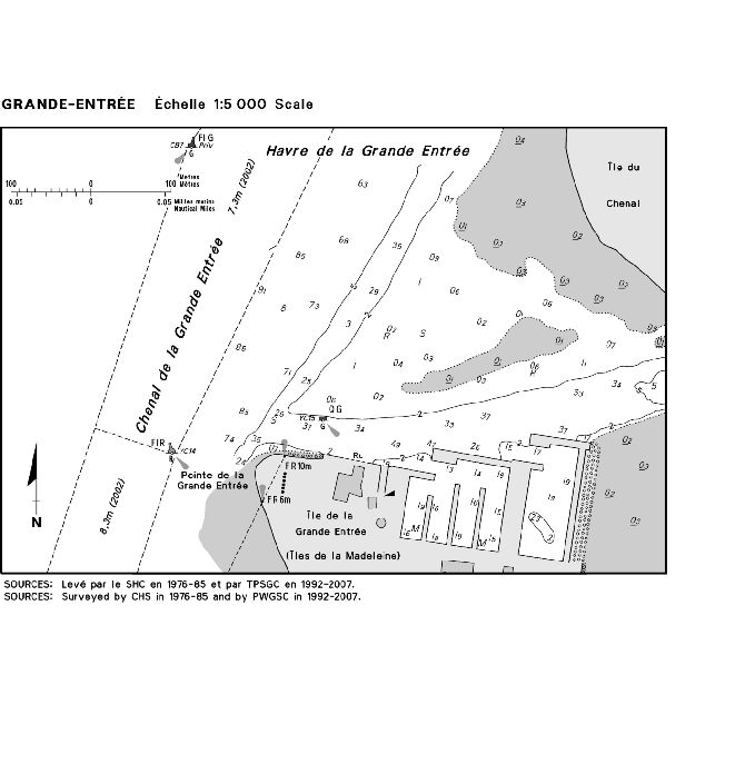
SECTION 5 – Edition 05/2008
LIST OF LIGHTS, BUOYS AND FOG SIGNALS CORRECTIONS
|
NEWFOUNDLAND | ||||||||||
|
14.4 |
St. Brides light buoy PSB2 |
46 54 52 54 11 04 |
Fl |
R |
4s |
..... |
..... |
Red, marked "PSB2. |
Seasonal. Chart:4841 Edn 05/08(N08-002) |
|
|
105.3 |
Fortune Harbour Wharf (Floating Dock) |
47 04 19.5 55 49 51 |
FI |
R |
4s |
3.2 |
2 |
Cylindrical mast. |
Year round. Chart:4832 Edn 05/08(N01-134) |
|
|
208.06 H155 |
Port Saunders Wharf |
50 38 43 57 16 26.9 |
Fl |
G |
4s |
2.1 |
..... |
Cylindrical mast. |
Year round. Chart:4679 Edn 05/08(N08-001) |
|
|
407.4 |
Cape Freels Harbour light buoy JF3 |
Delete from list. Chart: 4857 Edn 05/08(N08-004) | ||||||||
|
ATLANTIC | ||||||||||
|
8 H4188 |
Gannet Rock Racon - -. (G) X & S Band |
S. of Grand Manan. 44 30 37.1 66 46 52.9 |
Fl |
W |
5s |
28.2 |
19 |
|
Year round. Horn - Blast 2 s; sil. 3 s; blast 2 s; sil. 3 s; blast 2 s; sil. 48 s. Omnidirectional. Chart:4340 Edn 05/08(F08-017) |
|
|
11 H4186 |
Southwest Head |
On edge of cliff S. extremity of head. 44 36 02.9 66 54 19.8 |
Fl |
W |
10s |
47.5 |
16 |
White rectangular tower, red upper portion. 9.9 |
Operates at night only. Year round. Horn - Blast 6 s; sil. 54 s. Horn points 240°. Chart:4124 Edn 05/08(F08-018) |
|
|
25 H4178 |
Long Point |
Near S. extremity of Whitehead Island. 44 36 49.2 66 42 34.7 |
Iso |
W |
12s |
15.6 |
12 |
|
Year round. Horn - Blast 2 s; sil. 18 s. Horn points 180°. Chart:4340 Edn 05/08(F08-019) |
|
|
29 H4174 |
Great Duck Island |
S. end of island. 44 41 03.5 66 41 34.3 |
Fl |
W |
10s |
15.3 |
18 |
White rectangular tower, red upper portion. 8.9 |
Flash 1 s; eclipse 9 s. Operates at night only. Year round. Horn - Blast 4 s; sil. 56 s. Horn points 120° Chart:4340 Edn 05/08(F08-020) |
|
|
33 H4168 |
Swallowtail |
Near edge of high cliff, NE. part of island. 44 45 51.1 66 43 57.5 |
Oc |
W |
6s |
37.1 |
12 |
|
Flash 4 s; eclipse 2 s. Year round. Horn - Blast 2 s; sil. 18 s. Horn points 100°. Chart:4342 Edn 05/08(F08-021) |
|
|
167 H3938 |
Cape d'Or |
On extreme point. 45 17 27 64 46 27.5 |
Fl |
W |
9s |
20.3 |
13 |
White square tower, red upper portion. 10.7 |
Flash 1 s; eclipse 8 s. Year round. Horn - Blast 2 s; sil. 3 s; blast 2 s ; sil. 3 s; blast 2 s; sil. 48 s. Horn points 240°. Chart:4010 Edn 05/08(F08-022) |
|
|
171 H3950 |
Cape Sharp |
On S. extremity of cape. 45 21 52.2 64 23 31.5 |
Oc |
W |
10s |
17.4 |
12 |
|
Flash 7 s; eclipse 3 s. Year round. Horn - Blast 4 s; sil. 56 s. Horn points 250°. Chart:4399 Edn 05/08(F08-023) |
|
|
172 H3952 |
Parrsboro |
At entrance to harbour. 45 23 12.8 64 18 59.5 |
F |
G |
..... |
8.4 |
10 |
White square tower. 6.4 |
Year round. Horn - Blast 3 s; sil. 27 s. Horn points 170°. Chart:4399 Edn 05/08(F08-024) |
|
|
227 H3878 |
Peter Island |
S. entrance to Grand Passage. 44 15 26.4 66 20 15.3 |
Fl |
Y |
5s |
17.8 |
14 |
|
Flash 1 s; eclipse 4 s. Operates at night only. Year round. Horn - Blast 2 s; sil. 18 s. Chart:4118 Edn 05/08(F08-025) |
|
|
307 H3790 |
Outer Island |
On S. point. 43 27 23.2 65 44 36.2 |
Fl |
W |
10s |
13.7 |
10 |
White square tower, red upper portion. 11.6 |
Flash 1 s; eclipse 9 s. Year round. Chart:4210 Edn 05/08(F08-026) |
|
|
403 H3742.6 |
Hunts Landing |
On outer end of breakwater. 43 57 05.3 64 46 07.4 |
Iso |
R |
4s |
6.9 |
4 |
|
Operates at night only. Year round. Chart:4240 Edn 05/08(F08-013) |
|
|
504.5 |
Cronie Reef light buoy HS12 |
44 28 21.4 63 35 35.3 |
Fl |
R |
4s |
..... |
..... |
Red spar, marked "HS12". |
Year round. Chart:4237 Edn 05/08(F08-007) |
|
|
507 H3632 |
Sambro |
Centre of island. 44 26 12 63 33 48 |
Fl |
W |
5s |
42.7 |
22 |
White octagonal tower, red bands. 20.7 |
Flash every 5 s. Year round. Horns(2) - Blast 2 s; sil. 3 s; blast 2 s; sil. 3 s; blast 2 s; sil. 48 s. Horns point 068° and 178°. Horns sound in unison. Chart:4237 Edn 05/08(F08-027) |
|
|
513 H3600 |
Chebucto Head Racon - -.. (Z) X Band |
On summit. 44 30 26.6 63 31 21.8 |
Fl |
W |
20s |
47.8 |
13 |
White tower, red upper portion. 12.9 |
Flash 0.5 s; eclipse 19.5 s. Visible from 155° through S. and W. to 000°. Connected by telephone with Halifax. Year round. Horn - Blast 3 s; sil. 3 s; blast 3 s;sil. 51 s. Horn points 113°. Chart:4385 Edn 05/08(F08-028) |
|
|
686.6 |
Chedabucto Bay light and bell buoy C1 |
Delete from list. Chart:4308 Edn 05/08(G08-031) |
||||||||
|
728 H3378 |
Cape Ronde |
Delete from list. Chart:4275 Edn 05/08(G07-181) |
||||||||
|
961 |
Murray Harbour light buoy NM |
Off harbour entrance. 46 02 05.2 62 27 08.2 |
Mo(A) |
W |
6s |
..... |
..... |
Red and white vertical stripes spar, marked "NM". |
Seasonal. Chart:4420 Edn 05/08(G08-028) | |
|
INLAND WATERS | ||||||||||
|
528 |
Oakville |
On S. end of E. pier. 43 26 22 79 39 55.6 |
Iso |
R |
2s |
12.0 |
6 |
White cylindrical tower, red upper portion. 7.6 |
Privately maintained. Seasonal. Horn - Blast 3 s; sil. 17 s. Horn points 137°. In operation 1200Z to 0200Z. Chart:2077 Edn 05/08(B08-073) |
|
|
612.8 |
Leamington Harbour Main Entrance |
42 01 28.2 82 36 04.7 |
Iso |
G |
4s |
6.2 |
6 |
White cylindrical tower, green upper portion. 4.9 |
Visible over an arc of 360°; reduced intensity of 180°; from 120° through S. and W. to 300°. Seasonal. Chart:2181 Edn 05/08(D08-074) |
|
|
836 837 |
Owen Sound range |
| | | | | | | | |
E. side of Sydenham River mouth. 44 34 39.6 80 56 28 195°17' 316.9m from front. |
F F |
G G |
..... ..... |
15.0 24.9 |
11 ..... |
White and red skeleton tower, red rectangular daymark. 13.0 Skeleton tower, white daymark, orange vertical stripe. 22.8 |
Visible in line of range. Seasonal. Visible in line of range. Seasonal. Chart:2283 Edn 05/08(D08-022) |
|
909 910 |
Snug Harbour range |
| | | | | | | | | |
On the westernmost Walton Island. 45 22 15 80 19 19.5 070°40' 902.9m from front. |
F F |
G G |
..... ..... |
11.8 17.5 |
21 21 |
Skeleton tower, red daymark, black vertical stripe. 7.0 White square tower, red upper portion, black vertical stripe. 14.7 |
Seasonal. Seasonal. Chart:2225 Edn 05/08(D08-016,017) |
|
957 958 |
Byng Inlet range |
| | | | | | | | |
Close to S. side of channel. 45 45 07.4 80 38 40.8 074°24' 461m from front. |
F F |
R R |
..... ..... |
11.6 17.4 |
11 11 |
White and orange square tower. 10.4 White skeleton tower, orange rectangular daymark. 14.4 |
Visible in and over a small arc on each side of range. Seasonal. Seasonal. Chart:2293 Edn 05/08(D08-018) |
|
1089 |
Montréal Point |
On high bluff on point at Montréal River entrance. 47 14 27.4 84 39 02.4 |
Fl |
W |
10s |
39.3 |
..... |
Cylindrical mast, red and white rectangular daymark. 8.1 |
Flash 1 s; eclipse 9 s. Seasonal. Chart:2307 Edn 05/08(D08-014) |
|
|
1099 1100 |
Québec Harbour range |
| | | | | | | | |
On N. shore of harbour. 47 43 00.5 85 47 54.3 000°51' 214m from front. |
F F |
R R |
..... ..... |
6.4 20.1 |
..... ..... |
Skeleton tower, white daymark, orange vertical stripe. Square skeleton tower, white daymark, orange vertical stripe. |
Visible in line of range. Seasonal. Visible in line of range. Seasonal. Chart:2315 Edn 05/08(D08-012,013) |
|
1672 |
Grant Point Reef light buoy EG3 |
Off reef, NE. of Grant Point. 61 30 52 112 53 15 |
Fl |
G |
4s |
..... |
..... |
Green, marked "EG3". |
Seasonal. Chart:6341 Edn 05/08(A08-007) |
|
|
1686 |
Mackenzie Rock light buoy HM2 |
N. of entrance to Birch Creek. 60 52 16 115 21 30 |
Q |
R |
1s |
..... |
..... |
Red, marked "HM2". |
Seasonal. Chart:6370 Edn 05/08(A08-005) | |

