
Archived information
The Standard on Web Usability replaces this content. This content is archived because Common Look and Feel 2.0 Standards have been rescinded.
Archived information is provided for reference, research or recordkeeping purposes. It is not subject to the Government of Canada Web Standards and has not been altered or updated since it was archived.
|
|
Fisheries and Oceans Canada |
Pêches et Océans Canada |
VOL. 36, MONTHLY EDITION NO 03 March 25, 2011 Publication Number 40063779 |
NOTICES TO MARINERS
PUBLICATION EASTERN EDITION |
|||
Published monthly by the
CANADIAN COAST GUARD |
|||
|
|
|||
Page |
|||
| Section 1 |
Safety and General Information | 1 - 3 |
|
| Section 2 |
Chart Corrections | 4 - 25 |
|
| Section 3 |
Corrections to Radio Aids to Marine Navigation | NIL |
|
| Section 4 |
Sailing Directions and Small Craft Guide Corrections | 26 - 29 |
|
| Section 5 |
List of Lights, Buoys and Fog signals Corrections | 30 - 40 |
|
Maritime Services Directorate Aids to Navigation |
|||
EXPLANATORY NOTES |
Geographical positions refer directly to the graduations of the largest scale Canadian Hydrographic chart unless otherwise indicated. |
Bearings refer to the true compass and are measured clockwise from 000° (North) clockwise to 359°; those relating to lights are from seaward. |
Visibility of lights is that in clear weather. |
Depths - The units used for soundings (metres, fathoms or feet) are stated in the title of each chart. |
Elevations are normally given above Higher High Water, Large Tides unless otherwise indicated. |
Distances may be calculated as follows: |
1 nautical mile = 1 852 metres (6,076.1 feet) 1 statute mile = 1 609.3 metres (5,280 feet) 1 metre = 3.28 feet |
Temporary & Preliminary Notices are indicated by a (T) or a (P) before the chart action and in the section 1. Please note that Nautical charts are not amended by the Canadian Hydrographic Service for Temporary (T) and Preliminary (P) Notices. It is recommended that mariners chart these corrections in pencil. Listing of charts affected by Temporary and Preliminary Notices are revised and promulgated quarterly in Section 1 of the Monthly Edition . |
Please note that, in addition to the temporary and preliminary changes normally advertised as (T) and (P) Notices, there are a few permanent changes to navigational aids that have been advertised as Preliminary Notices to Mariners while charts are being updated for new editions. |
Marine Information Report & Suggestion Sheet - Mariners are requested to notify the responsible authorities when new or suspected dangers to navigation are discovered, changes observed in aids to navigation or corrections to publications are seen to be necessary. Such communications can be made using the Marine Information Report & Suggestion Sheet inserted on the last page of each monthly edition of Notices to Mariners. |
Monthly Notices to Mariners - WEB ACCESS -We are offering a feature where subscribers to our on-line service are able to receive the complete electronic monthly edition of our Notices to Mariners. We are encouraging our clients to visit the http://www.notmar.gc.ca/subscribe/ user-friendly web site to subscribe for this service. Users wishing to receive information updates for their charts can do so by setting up a "User Profile" on the following web page – http://www.notmar.gc.ca/search/mycharts-eng.php?czoxOToibnRtPXN0ZXBfb25lJmxhbmc9ZSI7. This feature permits users to register the nautical charts they currently have in their possession. Registrants are then automatically notified by e-mail when a Notices to Mariners is published concerning these charts. |
Canadian Nautical Charts & Publications - A source list of Canadian Nautical Charts & publications is published in Notice No. 14 of the Notices to Mariners Annual Edition April 2010. The source supply and the prices effective at the time of printing are listed. For current chart edition dates refer to the following web site: http://www.chs-shc.gc.ca/charts-cartes/paper-papier/index-eng.asp |
NOTE: Cette publication est aussi disponible en français. |
CHART CORRECTIONS - SECTION 2 |
|
Corrections to nautical charts will be listed in numeric order by chart number. Each chart correction listed applies only to that particular chart. Related charts, if any, will have their own specific correction listed separately. Users should also refer to CHS Chart 1 Symbols, Abbreviations Terms for additional information pertaining to the correction of charts. The illustration below describes the elements that will comprise a typical Section 2 chart correction. |

ADVISORY |
|
NOTICES TO SHIPPING (WRITTEN AND BROADCAST) |
|
The Canadian Coast Guard is implementing a number of changes to the aids to navigation system in Canada . |
|
These changes are advertised as Notices to Shipping (Broadcast and Written) by the Canadian Coast Guard and are followed up with Notices to Mariners, then charts are updated by hand correction, reprints or new editions. |
|
Mariners are advised that all relevant Written Notices to Shipping should be kept until superseded by Notices to Mariners or through revised charts issued by the Canadian Hydrographic Service. |
|
Written Notices to Shipping are published weekly and are available from local Canadian Coast Guard Offices. |
|
The Canadian Hydrographic Service is reviewing the impact of these changes with the Canadian Coast Guard and together we are preparing an action plan on the issuing of chart revisions. |
|
For further information contact your local Regional Notices to Shipping (Notships) issuing authorities. |
|
|

|
MONTHLY EDITION OF NOTICES TO MARINERS |
WEB ACCESS |
We are offering a feature where subscribers to our on-line service are able to receive the complete electronic monthly edition of our Notices to Mariners. We are encouraging our clients to visit the http://www.notmar.gc.ca /subscribe / web site to subscribe for this service. Users wishing to receive information updates for their charts can do so by setting up a "User Profile" on the following web page http://www.notmar.gc.ca/search/mycharts-eng.php?czoxOToibnRtPXN0ZXBfb25lJmxhbmc9ZSI7 This feature permits users to register the nautical charts they currently have in their possession. Registrants are then automatically notified by e-mail when a Notice to Mariners is published concerning these charts. |
INDEX |
|
CANADIAN HYDROGRAPHIC SERVICE - ANNOUNCEMENT REGARDING CANADIAN HYDROGRAPHIC SERVICE CHART PATCHES |
1 |
CANADIAN HYDROGRAPHIC SERVICE - CUMULATIVE CHART CORRECTIONS |
1 |
CANADIAN HYDROGRAPHIC SERVICE - CURRENT CHART EDITION DATES |
1 |
CANADIAN HYDROGRAPHIC SERVICE - PRINT ON DEMAND CHARTS - CARE AND USE |
1 |
CANADIAN HYDROGRAPHIC SERVICE - TRANSPORT CANADA NAVIGATION SAFETY - ECDIS |
1 |
*302 CANADIAN HYDROGRAPHIC SERVICE - ELECTRONIC NAVIGATIONAL CHARTS |
2 |
*301 CANADIAN HYDROGRAPHIC SERVICE - NAUTICAL CHARTS |
2 |
*304 CANADIAN HYDROGRAPHIC SERVICE - NEW EDITION OF CHART 1 SYMBOLS ABBREVIATIONS TERMS 2011 |
2 |
*303 CANADIAN HYDROGRAPHIC SERVICE - RASTER DIGITAL CHARTS (BSB V4) |
2 |
*307 CAPE CANSO TO/À COUNTRY ISLAND - INFORMATION REGARDING BUOYS |
3 |
*306 CAPE SABLE TO/À PUBNICO HARBOUR - LIGHT PERMANENTLY CHANGED |
3 |
*310 CHENAL DU HAVRE DE LA GRANDE ENTRÉE - BUOYS PERMANENTLY DISCONTINUED |
3 |
*309 ÎLES DE LA MADELEINE - BUOYS PERMANENTLY DISCONTINUED |
3 |
*308 LAC DES DEUX MONTAGNES - INFORMATION REGARDING BUOYS |
3 |
*305 SAINTJOHN HARBOUR AND APPROACHES / ET LES APPROCHES - TEMPORARY AID DISCONTINUED |
3 |
NUMERICAL INDEX OF CANADIAN CHARTS AFFECTED |
|||||
Chart No. |
Page |
Chart No. |
Page |
Chart No. |
Page |
1220 |
4 |
4275 |
3,12 |
L/C 4913 |
20 |
1310 |
4,5 |
4279 |
12 |
4920 |
20 |
1311 |
5 |
4363 |
12 |
4921 |
21 |
1312 |
5 |
4367 |
12 |
4950 |
21,22 |
1314 |
6 |
4374 |
12,13 |
4956 |
22 |
1315 |
6 |
4381 |
13,14 |
4980 |
22-24 |
1316 |
6,7 |
4405 |
14 |
5056 |
24 |
1317 |
7,8 |
4425 |
14 |
5057 |
2 |
1430 |
8 |
4428 |
14 |
5059 |
24 |
1509 |
8 |
4466 |
15,16 |
6218 |
24 |
4001 |
8 |
4474 |
16 |
6248 |
24,25 |
4003 |
8 |
4483 |
16 |
6249 |
25 |
4006 |
9 |
4486 |
17 |
8046 |
25 |
4013 |
9 |
4492 |
17 |
||
4015 |
9 |
4498 |
17 |
||
4016 |
9 |
4615 |
17,18 |
||
4022 |
10 |
4624 |
18 |
||
4023 |
10 |
4625 |
18 |
||
4024 |
10 |
4641 |
18 |
||
4047 |
11 |
4642 |
18 |
||
4117 |
3 |
4765 |
2 |
||
L/C 4118 |
11 |
4769 |
18 |
||
4209 |
11 |
4775 |
19 |
||
L/C 4227 |
11 |
4776 |
19 |
||
4235 |
11 |
4821 |
19 |
||
4241 |
11 |
4909 |
19 |
||
4243 |
11 |
4912 |
19,20 |
||
CANADIAN HYDROGRAPHIC SERVICE - ANNOUNCEMENT REGARDING CANADIAN HYDROGRAPHIC SERVICE CHART PATCHES
Colour Web Patches are free to the mariner, and given the quality of many printers, should reproduce well. They will be available in real time all around the world.
CHS welcomes your feedback on this service at chsinfo@dfo-mpo.gc.ca
CANADIAN HYDROGRAPHIC SERVICE - CUMULATIVE CHART CORRECTIONS
The cumulative Notices to Mariners corrections for charts can now be accessed at
http://www.notmar.gc.ca/search/notmar-eng.php
CANADIAN HYDROGRAPHIC SERVICE - CURRENT CHART EDITION DATES
|
CHART EDITIONS |
|
The three terms described below are used to indicate the publication status of Canadian charts. |
|
NEW CHART - "NEWCHT" |
|
The first publication of a Canadian chart embracing an area not previously charted to the scale shown, or embracing an area different from any existing Canadian chart. |
|
NEW EDITION - "NEWEDT" |
|
A new issue of an existing chart containing amendments essential to navigation in addition to those issued in Notices to Mariners and making existing editions obsolete. |
|
REPRINTS |
|
A new issue of the current edition of a chart incorporating no amendments of navigational significance other than those previously promulgated in Notices to Mariners. It may also contain amendments from other sources provided they are not essential to navigation. Previous printings of the current edition remain in force. |
The current chart edition dates can be accessed at http://www.chs-shc.gc.ca/charts-cartes/paper-papier/index-eng.asp
CANADIAN HYDROGRAPHIC SERVICE - PRINT ON DEMAND CHARTS - CARE AND USE
|
Background By providing nautical charts to the public, the goal of the Canadian Hydrographic Service (CHS) is to provide services for safe navigation in a fiscally responsible manner. As a result, CHS continues to expand its portfolio of nautical paper charts that are printed using Print On Demand (POD) technology. These charts are easily recognized by their whiter paper and the coloured logo of the Canadian Hydrographic Service. This new technology enables CHS to print charts in a more efficient manner while enhancing chart content through being able to quickly add new and important information. POD technology provides customers with up-to-date charts without the historical hand-drawn corrections or glued-on patches. Additionally, this technology eliminates out-of-stock situations which arise with the traditional printing and warehousing methods. In the event of a national emergency, CHS can respond to the appropriate authorities with best available information very quickly. Care of Your POD Chart CHS encourages its customers to handle the POD charts more carefully than the traditional lithographic charts. When plotting information on POD charts, use HB pencils and apply limited pressure. Testing has suggested that an Indian gum eraser is more effective than alternatives when used on the product. This eraser is also suitable for charts printed using lithographic processes. |
CANADIAN HYDROGRAPHIC SERVICE - TRANSPORT CANADA NAVIGATION SAFETY - ECDIS
|
Mariners are advised that ECDIS may not display some isolated shoal depths when operating in "base or standard display" mode. Route planning and monitoring alarms for these shoal depths may not always be activated. To ensure safe navigation and to confirm that a planned route is clear of such dangers, mariners should visually inspect the planned route and any deviations from it using ECDIS configured to display "all data". The automated voyage planning check function should not be solely relied upon. |
*301 CANADIAN HYDROGRAPHIC SERVICE - NAUTICAL CHARTS
|
CHARTS |
MAIN TITLE |
SCALE |
PUBLISHED |
CAT# |
PRICE |
|
New Chart |
All temporary and preliminary notices affecting the previous versions of the following chart is now cancelled. For any outstanding notices please consult section 2 of this edition. | ||||
|
5057 |
Hare Island to/à North Head |
1:100000 |
30-APR-2010 |
1 |
$20.00 |
|
|
|
|
|
|
|
|
Chart Permanently Withdrawn |
All temporary and preliminary notices affecting the previous versions of the following chart is now cancelled. | ||||
|
4765 |
Saglek Bay to/à Hebron Fiord |
|
|
|
|
*302 CANADIAN HYDROGRAPHIC SERVICE - ELECTRONIC NAVIGATIONAL CHARTS
|
RELEASED PRODUCTS |
|
|
S-57 ENC NUMBER |
CHART TITLE |
|
CA470070 |
Thetis Island to/à Nanaimo |
|
CA470072 |
Approaches to/Approches à Vancouver Harbour |
|
CA370141 |
Juan de Fuca Strait, Eastern Portion/Partie Est |
|
CA470267 |
Head of/Fond de Toba Inlet |
|
CA570297 |
Roberts Bank |
|
CA373089 |
Pelee Passage to/à la Detroit River |
|
CA476079 |
Head of/Fond de Placentia Bay |
|
CA376094 |
Strait of Belle Isle |
|
CA376109 |
Country Island to/à Barren Island |
|
CA476111 |
Country Harbour |
|
CA476133 |
Entrée à/Entrance to Miramichi River |
|
CA276138 |
Pointe Amour a/to Cape Whittle et/and Cape St. George |
|
CA276284 |
Sydney to Saint-Pierre |
|
CA579084 |
Chenal du Havre de la Grande Entrée |
|
CA579085 |
Quai / Wharf Mines Seleine |
|
CA579130 |
Port de Sorel-Tracy |
*303 CANADIAN HYDROGRAPHIC SERVICE - RASTER DIGITAL CHARTS (BSB V4)
|
CHARTS |
MAIN TITLE |
|
PUBLISHED |
|
|
|
New Chart |
All temporary and preliminary notices affecting the previous versions of the following chart(s) (is / are) now cancelled. For any outstanding notices please consult section 2 of this edition. | ||||
|
R/M7573 |
M'Clintock Channel, Larsen Sound and/et Franklin Strait |
|
25-FEB-2000 |
| |
|
New Editions |
All temporary and preliminary notices affecting the previous versions of the following chart(s) (is / are) now cancelled. For any outstanding notices please consult section 2 of this edition. | ||||
|
R/M1226 |
Mouillages et Installations Portuaires/Anchorages and Harbour Installations - Haute Côte-Nord |
|
19-FEB-2010 |
| |
|
R/M4839 |
Head of/Fond de Placentia Bay |
|
28-JAN-2011 |
| |
|
Reprints |
All temporary and preliminary notices affecting the following chart(s) (is / are) still in force. | ||||
|
R/M3053A |
Chase to/à Anglemont |
|
19-MAR-2010 |
|
|
|
R/M3053B |
Salmon Arm to/à Seymour Arm |
|
19-MAR-2010 |
|
|
*304 CANADIAN HYDROGRAPHIC SERVICE - NEW EDITION OF CHART 1 SYMBOLS ABBREVIATIONS TERMS 2011
The 2011 edition of the Chart 1 Symbols Abbreviations Terms has been published. The price of this publication is $16.00.
This publication can be downloaded free of charge from the following internet site at: http://www.charts.gc.ca/publications/chart1-carte1/index-eng.asp
This publication is also available through authorized Canadian Hydrographic Service (CHS) Chart dealers. A complete listing of authorized CHS chart dealers is available at the following Internet address: http://charts.gc.ca
*305 SAINTJOHN HARBOUR AND APPROACHES / ET LES APPROCHES - TEMPORARY AID DISCONTINUED
Reference: Notice 1009(T)/2010 is now cancelled (Chart: 4117).
Construction completed. The temporary sector light has been removed and the range lights (LL 110.3; 110.4) are back in operation.
*306 CAPE SABLE TO/À PUBNICO HARBOUR - LIGHT PERMANENTLY CHANGED
Reference: Notice 108(P)/2009 is now cancelled (Chart 4275).
(G2011-001)
*307 CAPE CANSO TO/À COUNTRY ISLAND - INFORMATION REGARDING BUOYS
Dover Harbour green spar buoy PQ11 (45°14'46".5 N 61°01'31".3 W) has been permanently discontinued.
Dover Harbour red spar buoy PQ14 has been permanently established at 45°16'54".8N 61°01'43".2W
Dover Harbour green spar buoy PQ15 has been permanently established at 45°17'09".3N 61°02'02".5W
Dover Harbour green spar buoy PQ17 has been permanently established at 45°17'16".5N 61°02'21".8W
(G2010-240, 241, 242, 248)
*308 LAC DES DEUX MONTAGNES - INFORMATION REGARDING BUOYS
Cautionary buoys, Carillon downstream booms have been established at:
Buoy 7 - 45°33'57".3N 74°22'53".3 W
Buoy 8 - 45°33'59" N 74°22'51".5 W
Buoy 9 - 45°34'00".8N 74°22'49".7 W
Buoy 10 - 45°33'02".5N 74°22'47".8 W
(Q2010-106, 107, 108, 109)
*309 ÎLES DE LA MADELEINE - BUOYS PERMANENTLY DISCONTINUED
Cautionary private buoys, Lagune Havre aux Maisons have been permanently discontinued:
47°25'17".6N 61°50'05".8 W
47°25'30".1N 61°50'01".6 W
47°26'18" N 61°48'50".6 W
47°26'11".4N 61°48'39".8 W
(Q2011- 011, 012,013, 014)
*310 CHENAL DU HAVRE DE LA GRANDE ENTRÉE - BUOYS PERMANENTLY DISCONTINUED
Cautionary private buoys, Lagune de Grande-Entrée have been permanently discontinued:
47°35'02".5N 61°31'25".4W
47°34'21".6N 61°30'52".3W
47°34'05".5N 61°31'26" W
47°34'47".7N 61°32'02".7W
47°36'23" N 61°31'57" W
47°34'05".5N 61°31'26" W
47°36'42".8N 61°30'58".1W
47°35'58".6N 61°31'24".7W
47°36'19".4N 61°30'37".1W
47°36'23" N 61°31'46".5W
(Q2011-031-039)
CHART CORRECTIONS
1220 - Sept-Îles - New Edition - 19-JUN-2009 - NAD 1983
18-MAR-2011 |
||
Delete |
berth 1 (See Chart No. 1, F19) |
50°11'04.9"N 066°21'45.7"W |
DFO(6408285-01) |
||
This notice might affect Electronic Navigational Chart: CA579008 |
||
1310 - Section B-C - Sheet 1 - New Edition - 15-FEB-2008 - NAD 1983
04-MAR-2011 |
LNM/D. 28-MAY-2010 |
|
Delete |
dredged area with depth of 7,9m (1999) (See Chart No. 1, I22) |
joining 45°37'29.3"N 73°29'56.5"W |
45°37'30.7"N 073°29'50.3"W |
||
45°37'29.4"N 073°29'51.4"W |
||
and 45°37'28.1"N 073°29'57.9"W |
||
DFO(6408239-01) |
||
Delete |
dredged area with depth of 6.1m (1999) (See Chart No. 1, I22) |
joining 45°37'31.6"N 73°29'54.2"W |
45°37'32.9"N 073°29'48.3"W |
||
45°37'30.7"N 073°29'50.3"W |
||
and 45°37'29.3"N 073°29'56.5"W |
||
DFO(6408239-02) |
||
Add |
dredged channel with maintained depth of 8,8 m (See Chart No. 1, I23) |
joining 45°37'30.8"N 73°29'55.1"W |
45°37'32.1"N 073°29'49.0"W |
||
45°37'29.4"N 073°29'51.4"W |
||
and 45°37'28.1"N 073°29'57.8"W |
||
DFO(6408239-03) |
||
Add |
dredged channel with maintained depth of 5,0 m (See Chart No. 1, I23) |
joining 45°37'31.6"N 73°29'54.2"W |
45°37'32.9"N 073°29'48.3"W |
||
45°37'32.1"N 073°29'49.0"W |
||
and 45°37'30.8"N 073°29'55.1"W |
||
DFO(6408239-04) |
||
1310 - Section A-B - Sheet 1 - New Edition - 15-FEB-2008 - NAD 1983
04-MAR-2011 |
LNM/D. 28-MAY-2010 |
|
Delete |
dredged area with depth of 7,9m (1999) (See Chart No. 1, I22) |
joining 45°37'29.3"N 73°29'56.5"W |
45°37'30.7"N 073°29'50.3"W |
||
45°37'29.4"N 073°29'51.4"W |
||
and 45°37'28.1"N 073°29'57.9"W |
||
DFO(6408239-01) |
||
This notice might affect Electronic Navigational Chart: CA579001 |
||
Delete |
dredged area with depth of 6.1m (1999) (See Chart No. 1, I22) |
joining 45°37'31.6"N 73°29'54.2"W |
45°37'32.9"N 073°29'48.3"W |
||
45°37'30.7"N 073°29'50.3"W |
||
and 45°37'29.3"N 073°29'56.5"W |
||
DFO(6408239-02) |
||
This notice might affect Electronic Navigational Chart: CA579001 |
||
Add |
dredged channel with maintained depth of 8,8 m (See Chart No. 1, I23) |
joining 45°37'30.8"N 73°29'55.1"W |
45°37'32.1"N 073°29'49.0"W |
||
45°37'29.4"N 073°29'51.4"W |
||
Add |
dredged channel with maintained depth of 8,8 m (See Chart No. 1, I23) |
and 45°37'28.1"N 073°29'57.8"W |
DFO(6408239-03) |
||
This notice might affect Electronic Navigational Chart: CA579001 |
||
Add |
dredged channel with maintained depth of 5,0 m (See Chart No. 1, I23) |
joining 45°37'31.6"N 73°29'54.2"W |
45°37'32.9"N 073°29'48.3"W |
||
45°37'32.1"N 073°29'49.0"W |
||
and 45°37'30.8"N 073°29'55.1"W |
||
DFO(6408239-04) |
||
This notice might affect Electronic Navigational Chart: CA579001 |
||
11-MAR-2011 |
LNM/D. 04-MAR-2011 |
|
Amend |
legend Q G 11m 14M to read Iso G 1s11m14M against light (See Chart No. 1, P10.3, P16) |
45°42'44.8"N 073°26'22.8"W |
(Q2010169) LL(2330) DFO(6408255-01) |
||
This notice might affect Electronic Navigational Chart: CA579001 |
||
Amend |
legend Q G 32m 14M to read Iso G 1s32m14M against light (See Chart No. 1,P10.3, P16) |
45°41'36.7"N 073°27'37.6"W |
(Q2010170) LL(2331) DFO(6408256-01) |
||
This notice might affect Electronic Navigational Chart: CA579001 |
||
1311 - Sorel-Tracy à / to Varennes - New Edition - 21-MAR-2008 - NAD 1983
11-MAR-2011 |
LNM/D. 27-AUG-2010 |
|
Amend |
legend Q G 11m 14M to read Iso G 1s11m14M against light (See Chart No. 1, P10.3, P16) |
45°42'44.8"N 073°26'22.8"W |
(Q2010169) LL(2330) DFO(6408255-01) |
||
This notice might affect Electronic Navigational Chart: CA479155 |
||
Amend |
legend Q G 32m 14M to read Iso G 1s32m14M against light (See Chart No. 1,P10.3, P16) |
45°41'36.7"N 073°27'37.6"W |
(Q2010170) LL(2331) DFO(6408256-01) |
||
This notice might affect Electronic Navigational Chart: CA479155 |
||
1312 - Lac Saint-Pierre - New Edition - 08-JUN-2007 - NAD 1983
18-MAR-2011 |
LNM/D. 25-FEB-2011 |
|
Add |
green port hand lighted spar buoy Fl G, marked S121 (See Chart No. 1, Qg) |
46°05'13.5"N 073°00'07.2"W |
(Q2010162) LL(2172.5) DFO(6408247-01) |
||
This notice might affect Electronic Navigational Chart: CA479129 |
||
25-MAR-2011 |
LNM/D. 18-MAR-2011 |
|
Amend |
F G 25m 13M to read F G 29m 13M against light (See Chart No. 1, P16) |
46°05'03.1"N 072°59'55.7"W |
(Q2011010) LL(2169) DFO(6408274-01) |
||
This notice might affect Electronic Navigational Chart: CA479129 |
||
Replace |
private red, green and red starboard bifurcation conical lighted buoy, Fl (2+1) R, Priv, marked ILETS with private red, green and red starboard bifurcation conical buoy, Priv, marked ILETS (See Chart No. 1, Qi) |
46°07'30.9"N 072°55'40.4"W |
(Q2011022) LL(2155) DFO(6408296-01) |
||
This notice might affect Electronic Navigational Chart: CA479129 |
||
Replace |
private red starboard hand lighted conical buoy , Fl R, Priv, marked SJ2 with private red starboard hand conical buoy, Priv, marked SJ2. (See Chart No. 1, Qf) |
46°07'48.1"N 072°55'58.4"W |
(Q2011023) LL(2156) DFO(6408297-01) |
||
This notice might affect Electronic Navigational Chart: CA479129 |
||
1314 - Donnacona à / to Batiscan - New Edition - 15-FEB-2008 - NAD 1983
11-MAR-2011 |
LNM/D. 06-AUG-2010 |
|
Add |
wreck WK with known depth of 16 metres and 5 decimetres (See Chart No. 1, K26) |
46°40'28.7"N 071°49'52.1"W |
DFO(6408259-01) |
||
This notice might affect Electronic Navigational Chart: CA479017 |
||
1315 - Québec à / to Donnacona - New Edition - 27-MAR-2009 - NAD 1983
11-MAR-2011 |
LNM/D. 24-DEC-2010 |
|
Delete |
depth of 30 metres (See Chart No. 1, I10) |
46°44'34.4"N 071°18'33.9"W |
DFO(6408260-01) |
||
This notice might affect Electronic Navigational Chart: CA479020 |
||
Add |
wreck WK with known depth of 22.5 metres (See Chart No. 1, K26) |
46°44'34.6"N 071°18'33.7"W |
DFO(6408260-02) |
||
This notice might affect Electronic Navigational Chart: CA479020 |
||
Add |
wreck WK with known depth of 18 metres 2 decimetres (See Chart No. 1, K26) |
46°46'26.2"N 071°14'18.5"W |
DFO(6408261-01) |
||
This notice might affect Electronic Navigational Chart: CA479020 |
||
Add |
wreck Wk with known depth of 23 metres (See Chart No. 1, K26) |
46°44'31.0"N 071°19'05.0"W |
DFO(6408265-01) |
||
This notice might affect Electronic Navigational Chart: CA479020 |
||
18-MAR-2011 |
LNM/D. 11-MAR-2011 |
|
Delete |
depth of 32 metres (See Chart No. 1, I10) |
46°47'11.9"N 071°12'29.7"W |
DFO(6408267-01) |
||
This notice might affect Electronic Navigational Chart: CA479020 |
||
Add |
wreck Wk with known depth of 27 metres 8 decimetres (See Chart No. 1, K26) |
46°47'10.6"N 071°12'32.6"W |
DFO(6408267-02) |
||
This notice might affect Electronic Navigational Chart: CA479020 |
||
Add |
wreck WK with known depth of 27 metres 6 decimetres (See Chart No. 1, K26) |
46°46'56.6"N 071°12'46.9"W |
DFO(6408267-03) |
||
This notice might affect Electronic Navigational Chart: CA479020 |
||
11-MAR-2011 |
LNM/D. 24-DEC-2010 |
|
Add |
wreck Wk with known depth of 25 metres 5 decimetres (See Chart No. 1, K26) |
46°49'40.3"N 071°11'27.8"W |
DFO(6408279-01) |
||
This notice might affect Electronic Navigational Chart: CA479020 |
||
1316 - Continuation A - Sheet 1 - New Edition - 23-JUN-2006 - NAD 1983
11-MAR-2011 |
LNM/D. 24-DEC-2010 |
|
Delete |
depth of 30 metres (See Chart No. 1, I10) |
46°44'34.4"N 071°18'33.9"W |
DFO(6408260-01) |
||
This notice might affect Electronic Navigational Chart: CA579081 |
||
Add |
wreck WK with known depth of 22.5 metres (See Chart No. 1, K26) |
46°44'34.6"N 071°18'33.7"W |
DFO(6408260-02) |
||
This notice might affect Electronic Navigational Chart: CA579081 |
||
Add |
wreck Wk with known depth of 23 metres (See Chart No. 1, K26) |
46°44'31.0"N 071°19'05.0"W |
DFO(6408265-01) |
||
This notice might affect Electronic Navigational Chart: CA579081 |
||
1316 - Port de Québec - Sheet 1 - New Edition - 23-JUN-2006 - NAD 1983
11-MAR-2011 |
LNM/D. 24-DEC-2010 |
|
Add |
wreck WK with known depth of 18 metres 2 decimetres (See Chart No. 1, K26) |
46°46'26.2"N 071°14'18.5"W |
DFO(6408261-01) |
||
This notice might affect Electronic Navigational Chart: CA579003 |
||
18-MAR-2011 |
LNM/D. 11-MAR-2011 |
|
Add |
wreck Wk with known depth of 27 metres 8 decimetres (See Chart No. 1, K26) |
46°47'10.6"N 071°12'32.6"W |
DFO(6408267-02) |
||
This notice might affect Electronic Navigational Chart: CA579003 |
||
Add |
wreck WK with known depth of 27 metres 6 decimetres (See Chart No. 1, K26) |
46°46'56.6"N 071°12'46.9"W |
DFO(6408267-03) |
||
This notice might affect Electronic Navigational Chart: CA579003 |
||
11-MAR-2011 |
LNM/D. 24-DEC-2010 |
|
Delete |
depth of 25 metres 7 decimetres (See Chart No. 1, I10) |
46°50'13.2"N 071°09'51.7"W |
DFO(6408278-01) |
||
This notice might affect Electronic Navigational Chart: CA579003 |
||
Add |
wreck WK with known depth of 23 metres 9 decimetres (See Chart No. 1, K26) |
46°50'12.6"N 071°09'51.1"W |
DFO(6408278-02) |
||
This notice might affect Electronic Navigational Chart: CA579003 |
||
Add |
wreck Wk with known depth of 25 metres 5 decimetres (See Chart No. 1, K26) |
46°49'40.3"N 071°11'27.8"W |
DFO(6408279-01) |
||
This notice might affect Electronic Navigational Chart: CA579003 |
||
1317 - Sault-au-Cochon à / to Québec - Sheet 1 - New Edition - 04-JUL-2008 - NAD 1983
25-MAR-2011 |
LNM/D. 18-MAR-2011 |
|
Add |
depth of 3 metres 4 decimetres (See Chart No. 1, I10) |
47°05'32.1"N 070°38'36.4"W |
DFO(6408317-01) |
||
This notice might affect Electronic Navigational Chart: CA479025 |
||
1317 - Continuation A - Sheet 1 - New Edition - 04-JUL-2008 - NAD 1983
04-MAR-2011 |
LNM/D. 15-OCT-2010 |
|
Add |
submerged wreck Wk with known depth of 29 metres 7 decimetres (See Chart No. 1, K26) |
46°50'29.8"N 071°03'29.1"W |
DFO(6408266-01) |
||
This notice might affect Electronic Navigational Chart: CA479082 |
||
18-MAR-2011 |
LNM/D. 11-MAR-2011 |
|
Delete |
depth of 32 metres (See Chart No. 1, I10) |
46°47'11.9"N 071°12'29.7"W |
DFO(6408267-01) |
||
Add |
wreck Wk with known depth of 27 metres 8 decimetres (See Chart No. 1, K26) |
46°47'10.6"N 071°12'32.6"W |
DFO(6408267-02) |
||
Add |
wreck WK with known depth of 27 metres 6 decimetres (See Chart No. 1, K26) |
46°46'56.6"N 071°12'46.9"W |
DFO(6408267-03) |
||
11-MAR-2011 |
LNM/D. 04-MAR-2011 |
|
Add |
wreck Wk with known depth of 21 metres 1 decimetre (See Chart No. 1, K26) |
46°50'15.0"N 071°03'52.7"W |
DFO(6408277-01) |
||
This notice might affect Electronic Navigational Chart: CA479082 |
||
Add |
wreck WK with known depth of 23 metres 9 decimetres (See Chart No. 1, K26) |
46°50'12.6"N 071°09'51.1"W |
DFO(6408278-02) |
||
This notice might affect Electronic Navigational Chart: CA479082 |
||
Add |
wreck Wk with known depth of 25 metres 5 decimetres (See Chart No. 1, K26) |
46°49'40.3"N 071°11'27.8"W |
DFO(6408279-01) |
||
1430 - Lac Saint-Louis - New Chart - 16-APR-2010 - NAD 1983
18-MAR-2011 |
LNM/D. 24-DEC-2010 |
|
Amend |
Q Y 8m to read Iso Y 1s 8m 15M against light (See Chart No. 1, P16) |
45°24'03.1"N 073°44'44.5"W |
(Q2011001) LL(8.2) DFO(6408262-01) |
||
This notice might affect Electronic Navigational Chart: CA479228 |
||
1509 - Île Bizard à / to Pont-Viau A-B - Sheet 1 - New Edition - 30-DEC-2005 - NAD 1983
11-MAR-2011 |
LNM/D. 07-JAN-2011 |
|
Replace |
red starboard hand spar buoy, marked HD54 with a red starboard hand pillar buoy, marked HD54 (See Chart No. 1, Qf) |
45°30'58.1"N 073°54'58.6"W |
DFO(6408118-01) |
||
Replace |
private yellow information spar lighted buoy Fl with private white and orange information spar lighted buoy Fl Y, Priv (See Chart No. 1, Qp) |
45°30'43.3"N 073°56'11.7"W |
DFO(6408118-02) |
||
4001 - Gulf of Maine to Strait of Belle Isle / au Detroit de Belle Isle - New Edition - 01-DEC-1995 - NAD 1983
25-MAR-2011 |
LNM/D. 14-JAN-2011 |
|
Delete |
private yellow ODAS/SADO lighted pillar buoy, marked 44402 (See Chart No 1 Q58) |
39°29'08.0"N 070°35'38.0"W |
DFO(6305297-01) |
||
4003 - Cape Breton to / à Cape Cod - New Edition - 21-MAR-2003 - NAD 1983
25-MAR-2011 |
LNM/D. 14-JAN-2011 |
|
Delete |
light Al (2) WR 19M with legend (Nauset Beach) (See Chart No 1 P16) |
41°51'36.0"N 069°57'12.0"W |
DFO(6305298-01) |
||
This notice might affect Electronic Navigational Chart: CA176140 |
||
4006 - Newfoundland and Labrador / Terre-Neuve-et-Labrador to Bermuda / aux Bermudes - New Edition - 08-AUG-2003 - NAD 1983
25-MAR-2011 |
LNM/D. 23-JUL-2010 |
|
Delete |
private yellow ODAS/SADO lighted pillar buoy, marked 44402 (See Chart No 1 Q58) |
39°29'08.0"N 070°35'38.0"W |
DFO(6305297-01) |
||
Add |
private yellow ODAS/SADO lighted super-buoy, marked 44402 (See Chart No 1 Q58) |
39°23'54.0"N 070°56'30.0"W |
DFO(6305297-02) |
||
4013 - Halifax to / à Sydney - New Edition - 06-SEP-2002 - NAD 1983
18-MAR-2011 |
LNM/D. 11-FEB-2011 |
|
Delete |
depth of 1 fathom, 3 feet (See Chart No. 1, I10) |
45°43'13.5"N 060°13'26.0"W |
DFO(6305289-10) |
||
This notice might affect Electronic Navigational Chart: CA276204 |
||
Delete |
depth of 0 fathoms, 5 feet (See Chart No. 1, I10) |
46°07'08.0"N 062°54'09.0"W |
DFO(6305295-12) |
||
Add |
depth of 0 fathoms, 4 feet (See Chart No. 1, I10) |
46°07'10.5"N 062°54'24.9"W |
DFO(6305295-13) |
||
4015 - Sydney to / à Saint-Pierre - New Edition - 28-MAR-2003 - NAD 1983
04-MAR-2011 |
LNM/D. 11-FEB-2011 |
|
Add |
depth of 44 fathoms over artificial feature (See Chart No 1 Ka) |
46°56'48.0"N 060°06'37.2"W |
The mooring is temporary. The proposed date of removal is June 2011. |
||
DFO(6305243-02) |
||
18-MAR-2011 |
LNM/D. 04-MAR-2011 |
|
Amend |
FlR 12s 89ft 5M to read LFlR 12s 89ft 7M against light (See Chart No. 1 P16) |
46°23'06.4"N 060°22'25.8"W |
(G2011051) LL(844) DFO(6305271-01) |
||
Delete |
depth of 1 fathom, 3 feet (See Chart No. 1, I10) |
45°43'13.5"N 060°13'26.0"W |
DFO(6305289-10) |
||
4016 - Saint-Pierre to / à St. John's - New Edition - 06-JUN-2003 - NAD 1983
04-MAR-2011 |
LNM/D. 31-DEC-2010 |
|
Delete |
islet (See Chart No 1 K10) |
47°20'36.0"N 054°54'47.0"W |
DFO(6305213-01) |
||
18-MAR-2011 |
LNM/D. 04-MAR-2011 |
|
Delete |
circular radiobeacon with legend R (See Chart No 1 S15) |
46°55'43.0"N 055°22'46.0"W |
DFO(6305286-01) |
||
4022 - Cabot Strait and Approaches / Détroit de Cabot et les approches, Scatarie Island to / à Anticosti Island / Île D'Anticosti - New Edition - 17-JAN-2003 - NAD 1983
04-MAR-2011 |
LNM/D. 11-FEB-2011 |
|
Add |
depth of 44 fathoms over artificial feature (See Chart No 1 Ka) |
48°02'26.4"N 061°09'51.6"W |
The mooring is temporary. The proposed date of removal is June 2011. |
||
DFO(6305243-01) |
||
This notice might affect Electronic Navigational Chart: CA276271 |
||
Add |
depth of 44 fathoms over artificial feature (See Chart No 1 Ka) |
46°56'48.0"N 060°06'37.2"W |
The mooring is temporary. The proposed date of removal is June 2011. |
||
DFO(6305243-02) |
||
This notice might affect Electronic Navigational Chart: CA276271 |
||
18-MAR-2011 |
LNM/D. 04-MAR-2011 |
|
Amend |
FlR 12s 89ft 5M to read LFlR 12s 89ft 7M against light (See Chart No. 1 P16) |
46°23'05.0"N 060°22'37.0"W |
(G2011051) LL(844) DFO(6305271-01) |
||
This notice might affect Electronic Navigational Chart: CA276271 |
||
Add |
spoil ground (See Chart No.1, N62.1) |
47°22'02.2"N 061°47'37.5"W |
DFO(6408286-03) |
||
4023 - Northumberland Strait / Détroit de Northumberland - New Edition - 27-DEC-2002 - NAD 1983
11-MAR-2011 |
LNM/D. 03-DEC-2010 |
|
Amend |
2 Lts QG & Iso G to read 2 Lts Iso G against light (See Chart No. 1 P16) |
46°28'06.9"N 062°04'05.1"W |
(G2011012) LL(1039) DFO(6305230-01) |
||
This notice might affect Electronic Navigational Chart: CA276286 |
||
18-MAR-2011 |
LNM/D. 11-MAR-2011 |
|
Delete |
depth of 0 fathoms, 5 feet (See Chart No. 1, I10) |
46°07'08.0"N 062°54'09.0"W |
DFO(6305295-12) |
||
This notice might affect Electronic Navigational Chart: CA276286 |
||
Add |
depth of 0 fathoms, 4 feet (See Chart No. 1, I10) |
46°07'10.5"N 062°54'24.9"W |
DFO(6305295-13) |
||
This notice might affect Electronic Navigational Chart: CA276286 |
||
4024 - Baie des Chaleurs / Chaleur Bay aux / to Îles de la Madeleine - New Edition - 03-MAR-2000 - NAD 1983
18-MAR-2011 |
LNM/D. 28-AUG-2009 |
||
Add |
fixed bridge (See Chart No. 1, D22) |
between 47°52'57.0"N 064°34'50.0"W |
|
and 47°53'35.5"N 064°35'00.0"W |
|||
DFO(6305273-02) |
|||
This notice might affect Electronic Navigational Chart: CA279075 |
|||
Add |
spoil ground (See Chart No.1, N62.1) |
47°22'02.2"N 061°47'37.5"W |
|
DFO(6408286-03) |
|||
This notice might affect Electronic Navigational Chart: CA279075 |
|||
4047 - St. Pierre Bank / Banc de Saint-Pierre to / au Whale Bank / Banc de la Baleine - New Edition - 09-OCT-1998 - NAD 1983
18-MAR-2011 |
LNM/D. 31-DEC-2010 |
|
Delete |
radar transponder beacon with legend Racon (See Chart No 1 S3.3) |
46°55'44.0"N 055°22'45.0"W |
DFO(6305286-01) |
||
This notice might affect Electronic Navigational Chart: CA276091 |
||
L/C4118 - St. Marys Bay - New Edition - 13-NOV-1998 - NAD 1983
18-MAR-2011 |
LNM/D. 05-JUN-2009 |
|
Reposition |
green port hand spar buoy, marked HD1 (See Chart No 1 Qg) |
from 44°13'38.0"N 066°09'05.0"W |
to 44°13'34.6"N 066°09'11.4"W |
||
(F2011003) DFO(6305275-01) |
||
4209 - Lockeport Harbour - Sheet 1 - New Chart - 21-OCT-1994 - NAD 1983
18-MAR-2011 |
LNM/D. 23-APR-2010 |
|
Amend |
FG to read LFlR against light (See Chart No 1 P16) |
43°42'52.6"N 065°06'33.6"W |
(F2011025) LL(373.5) DFO(6305292-01) |
||
This notice might affect Electronic Navigational Chart: CA576040 |
||
L/C4227 - Country Harbour to / au Ship Harbour - New Chart - 24-MAY-1991 - NAD 1983
25-MAR-2011 |
LNM/D. 14-JAN-2011 |
|
Amend |
F 22m to read F 20m 18M against light (See Chart No 1 P16) |
44°51'38.6"N 062°26'57.2"W |
(F2011026) LL(599) DFO(6305288-01) |
||
This notice might affect Electronic Navigational Chart: CA376061 |
||
4235 - Barren Island to / à Taylors Head - New Edition - 28-APR-2000 - NAD 1983
25-MAR-2011 |
LNM/D. 02-JUL-2010 |
|
Amend |
F 22m to read F 20m 18M against light (See Chart No 1 P16) |
44°51'38.6"N 062°26'57.2"W |
(F2011026) LL(599) DFO(6305288-01) |
||
This notice might affect Electronic Navigational Chart: CA376102 |
||
4241 - Lockeport to / à Cape Sable - New Edition - 08-NOV-2002 - NAD 1983
18-MAR-2011 |
LNM/D. 23-APR-2010 |
|
Amend |
FR to read LFlR against light (See Chart No 1 P16) |
43°30'19.6"N 065°28'11.1"W |
(F2011035) LL(343) DFO(6305294-01) |
||
This notice might affect Electronic Navigational Chart: CA376047 |
||
4243 - Tusket Islands to / à Cape St. Marys - New Edition - 11-OCT-2002 - NAD 1983
11-MAR-2011 |
LNM/D. 27-FEB-2009 |
||
Add |
breakwater (See Chart 1 F4.1) |
between 43°55'08.8"N 066°09'13.2"W |
|
and 43°55'12.8"N 066°09'19.5"W |
|||
DFO(6305287-01) |
|||
This notice might affect Electronic Navigational Chart: CA376018 |
|||
Add |
private light FlY(Priv) (See Chart No 1 P1) |
43°55'12.8"N 066°09'19.5"W |
|
DFO(6305287-02) |
|||
This notice might affect Electronic Navigational Chart: CA376018 |
|||
4275 - St. Peters Bay - New Edition - 28-JUN-2002 - NAD 1983
04-MAR-2011 |
LNM/D. 18-JUN-2010 |
|
Amend |
Fl R to read Fl G against light (See Chart No. 1 P16) |
45°39'58.2"N 060°51'21.1"W |
(G2011001) LL(843) DFO(6305218-01) |
||
4279 - Bras D'Or Lake - New Edition - 28-AUG-1998 - NAD 1983
04-MAR-2011 |
LNM/D. 30-APR-2010 |
|
Amend |
Fl R to read Fl G against light (See Chart No. 1 P16) |
45°39'58.2"N 060°51'21.1"W |
(G2011001) LL(843) DFO(6305218-02) |
||
This notice might affect Electronic Navigational Chart: CA376272 |
||
4363 - Cape Smoky to / à St. Paul Island - New Edition - 12-SEP-2003 - NAD 1983
04-MAR-2011 |
LNM/D. 04-JUN-2010 |
|
Add |
depth of 44 fathoms over artificial feature (See Chart No 1 Ka) |
46°56'48.0"N 060°06'37.2"W |
The mooring is temporary. The proposed date of removal is June 2011. |
||
DFO(6305243-02) |
||
This notice might affect Electronic Navigational Chart: CA376167 |
||
4367 - Flint Island to / à Cape Smokey - New Edition - 03-APR-2003 - NAD 1983
18-MAR-2011 |
LNM/D. 29-OCT-2010 |
|
Amend |
FlR 12s 89ft 5M to read LFlR 12s 89ft 7M against light (See Chart No. 1 P16) |
46°23'06.4"N 060°22'25.8"W |
(G2011051) LL(844) DFO(6305271-01) |
||
This notice might affect Electronic Navigational Chart: CA376093 |
||
4374 - Red Point to / à Guyon Island - New Edition - 08-NOV-2002 - NAD 1983
18-MAR-2011 |
LNM/D. 12-JUN-2009 |
|
Delete |
depth of 1 fathom (See Chart No. 1, I10) |
45°43'04.4"N 060°14'45.0"W |
DFO(6305289-01) |
||
This notice might affect Electronic Navigational Chart: CA376295 |
||
Add |
depth of 0 fathoms, 2 feet (See Chart No. 1, I10) |
45°43'03.7"N 060°14'43.4"W |
DFO(6305289-02) |
||
Delete |
depth of 1 fathom (See Chart No. 1, I10) |
45°43'15.1"N 060°14'07.6"W |
DFO(6305289-03) |
||
This notice might affect Electronic Navigational Chart: CA376295 |
||
Add |
depth of 0 fathoms, 3 feet (See Chart No. 1, I10) |
45°43'16.2"N 060°14'05.2"W |
DFO(6305289-04) |
||
This notice might affect Electronic Navigational Chart: CA376295 |
||
Delete |
depth of 1 fathom, 5 feet (See Chart No. 1, I10) |
45°43'19.5"N 060°13'49.3"W |
DFO(6305289-05) |
||
This notice might affect Electronic Navigational Chart: CA376295 |
||
Add |
depth of 1 fathom, 2 feet (See Chart No. 1, I10) |
45°43'18.6"N 060°13'50.9"W |
DFO(6305289-06) |
||
This notice might affect Electronic Navigational Chart: CA376295 |
||
Add |
depth of 0 fathoms, 2 feet (See Chart No. 1, I10) |
45°43'11.2"N 060°13'24.9"W |
DFO(6305289-07) |
||
This notice might affect Electronic Navigational Chart: CA376295 |
||
Delete |
depth of 1 fathom, 3 feet (See Chart No. 1, I10) |
45°43'10.5"N 060°12'57.5"W |
DFO(6305289-08) |
||
This notice might affect Electronic Navigational Chart: CA376295 |
||
Add |
depth of 0 fathoms, 4 feet (See Chart No. 1, I10) |
45°43'11.0"N 060°13'01.4"W |
DFO(6305289-09) |
||
This notice might affect Electronic Navigational Chart: CA376295 |
||
4381 - Mahone Bay - New Edition - 31-JAN-2003 - NAD 1983
18-MAR-2011 |
LNM/D. 26-NOV-2010 |
||
Add |
ferry route (See Chart No. 1, M50) |
joining 44°31'58.9"N 064°14'14.2"W |
|
44°31'20.6"N 064°14'06.7"W |
|||
44°30'59.9"N 064°13'39.8"W |
|||
44°30'32.8"N 064°12'44.9"W |
|||
44°28'18.4"N 064°10'50.2"W |
|||
44°27'52.1"N 064°10'17.5"W |
|||
44°28'11.9"N 064°10'31.7"W |
|||
44°28'34.9"N 064°09'36.5"W |
|||
and 44°28'18.7"N 064°08'32.3"W |
|||
DFO(6305282-02) |
|||
Add |
ferry route (See Chart No. 1, M50) |
joining 44°28'24.8"N 064°08'36.9"W |
|
44°31'32.5"N 064°12'13.1"W |
|||
44°31'50.4"N 064°13'17.8"W |
|||
44°31'52.0"N 064°13'58.4"W |
|||
and 44°32'02.1"N 064°14'07.2"W |
|||
DFO(6305282-03) |
|||
Add |
ferry route (See Chart No. 1, M50) |
joining 44°28'22.3"N 064°08'38.6"W |
|
44°29'16.0"N 064°10'36.7"W |
|||
and 44°30'32.8"N 064°12'44.9"W |
|||
DFO(6305282-04) |
|||
4381 - Mahone Harbour - New Edition - 31-JAN-2003 - NAD 1983
18-MAR-2011 |
LNM/D. 26-NOV-2010 |
|
Delete |
green port hand spar buoy, marked MH57 (See Chart No 1 Qg) |
44°26'41.4"N 064°21'13.7"W |
(F2011004) DFO(6305276-01) |
||
This notice might affect Electronic Navigational Chart: CA576201 |
||
Add |
black and yellow North cardinal spar buoy, marked MHA (See Chart No. 1, Q130.3) |
44°26'41.4"N 064°21'13.7"W |
(F2011004) DFO(6305276-02) |
||
This notice might affect Electronic Navigational Chart: CA576201 |
||
4381 - Chester Harbour - New Edition - 31-JAN-2003 - NAD 1983
18-MAR-2011 |
LNM/D. 26-NOV-2010 |
|
Add |
ferry route |
joining 44°31'33.0"N 064°12'14.7"W |
44°31'50.4"N 064°13'17.8"W |
||
44°31'52.0"N 064°13'58.4"W |
||
44°32'13.5"N 064°14'17.1"W |
||
44°31'20.6"N 064°14'06.7"W |
||
44°30'59.9"N 064°13'39.8"W |
||
and 44°30'43.6"N 064°13'06.7"W |
||
DFO(6305282-01) |
||
This notice might affect Electronic Navigational Chart: CA576200 |
||
4405 - Pictou Island to / aux Tryon Shoals - New Edition - 21-FEB-2003 - NAD 1983
18-MAR-2011 |
LNM/D. 02-JUL-2010 |
|
Delete |
depth of 10 feet (See Chart No. 1, I10) |
46°10'11.4"N 062°52'49.0"W |
DFO(6305295-01) |
||
Delete |
depth of 11 feet (See Chart No. 1, I10) |
46°09'55.7"N 062°52'54.7"W |
DFO(6305295-02) |
||
Add |
depth of 7 feet (See Chart No. 1, I10) |
46°09'55.1"N 062°52'55.9"W |
DFO(6305295-03) |
||
Delete |
depth of 16 feet (See Chart No. 1, I10) |
46°09'29.8"N 062°53'21.0"W |
DFO(6305295-06) |
||
Add |
depth of 10 feet (See Chart No. 1, I10) |
46°09'31.5"N 062°53'21.2"W |
DFO(6305295-08) |
||
Delete |
depth of 31 feet (See Chart No. 1, I10) |
46°09'00.8"N 062°53'33.5"W |
DFO(6305295-09) |
||
Add |
depth of 4 feet (See Chart No. 1, I10) |
46°07'10.5"N 062°54'24.9"W |
DFO(6305295-13) |
||
4425 - Savage Harbour - Sheet 1 - New Edition - 01-NOV-2002 - NAD 1983
04-MAR-2011 |
LNM/D. 26-NOV-2010 |
|
Delete |
green port hand lighted pillar buoy FlG, marked JE9 (See Chart No. 1, Qg) |
46°25'44.5"N 062°50'05.0"W |
LL(1047.028) DFO(6305265-01) |
||
4428 - Havre de Natashquan et les approches / and Approaches - New Edition - 15-FEB-2008 - NAD 1983
04-MAR-2011 |
LNM/D. 24-APR-2009 |
|
Delete |
the two tanks (See Chart No. 1, E32) |
50°11'20.6"N 061°50'23.1"W |
DFO(6408264-01) |
||
This notice might affect Electronic Navigational Chart: CA579098 |
||
Delete |
the legend Tanks (See Chart No. 1, E32) |
50°11'21.8"N 061°50'23.0"W |
DFO(6408264-02) |
||
This notice might affect Electronic Navigational Chart: CA579098 |
||
4466 - Hillsborough Bay - New Edition - 21-MAR-2003 - NAD 1983
18-MAR-2011 |
LNM/D. 17-SEP-2010 |
|
Delete |
depth of 10 feet (See Chart No. 1, I10) |
46°10'12.9"N 062°52'51.0"W |
DFO(6305295-01) |
||
This notice might affect Electronic Navigational Chart: CA476179 |
||
Delete |
depth of 11 feet (See Chart No. 1, I10) |
46°09'56.9"N 062°52'56.3"W |
DFO(6305295-02) |
||
This notice might affect Electronic Navigational Chart: CA476179 |
||
Add |
depth of 7 feet (See Chart No. 1, I10) |
46°09'55.1"N 062°52'55.9"W |
DFO(6305295-03) |
||
This notice might affect Electronic Navigational Chart: CA476179 |
||
Delete |
depth of 16 feet (See Chart No. 1, I10) |
46°09'46.7"N 062°52'58.9"W |
DFO(6305295-04) |
||
This notice might affect Electronic Navigational Chart: CA476179 |
||
Delete |
depth of 14 feet (See Chart No. 1, I10) |
46°09'32.2"N 062°53'16.2"W |
DFO(6305295-05) |
||
This notice might affect Electronic Navigational Chart: CA476179 |
||
Delete |
depth of 16 feet (See Chart No. 1, I10) |
46°09'29.8"N 062°53'23.2"W |
DFO(6305295-06) |
||
This notice might affect Electronic Navigational Chart: CA476179 |
||
Delete |
depth of 18 feet (See Chart No. 1, I10) |
46°09'28.5"N 062°53'26.6"W |
DFO(6305295-07) |
||
This notice might affect Electronic Navigational Chart: CA476179 |
||
Add |
depth of 10 feet (See Chart No. 1, I10) |
46°09'31.5"N 062°53'21.2"W |
DFO(6305295-08) |
||
This notice might affect Electronic Navigational Chart: CA476179 |
||
Delete |
depth of 31 feet (See Chart No. 1, I10) |
46°09'00.8"N 062°53'35.7"W |
DFO(6305295-09) |
||
This notice might affect Electronic Navigational Chart: CA476179 |
||
Delete |
depth of 15 feet (See Chart No. 1, I10) |
46°08'40.1"N 062°53'37.5"W |
DFO(6305295-10) |
||
This notice might affect Electronic Navigational Chart: CA476179 |
||
Add |
depth of 11 feet (See Chart No. 1, I10) |
46°08'39.6"N 062°53'37.7"W |
DFO(6305295-11) |
||
This notice might affect Electronic Navigational Chart: CA476179 |
||
Add |
depth of 4 feet (See Chart No. 1, I10) |
46°07'10.5"N 062°54'24.9"W |
DFO(6305295-13) |
||
This notice might affect Electronic Navigational Chart: CA476179 |
||
Delete |
depth of 7 feet (See Chart No. 1, I10) |
46°07'03.1"N 062°54'45.6"W |
DFO(6305295-14) |
||
This notice might affect Electronic Navigational Chart: CA476179 |
||
4474 - Baie de la Tabatière - New Edition - 28-MAY-1999 - NAD 1983
11-MAR-2011 |
LNM/D. 19-SEP-2008 |
|
Delete |
depth of 2 fathoms 3 feet (See Chart No. 1, I10) |
38°50', 355 m from South West corner of inset border |
DFO(6408257-01) |
||
Add |
depth of 0 fathoms 3 feet (See Chart No. 1, I10) |
41°26', 359 m from South West corner of inset border |
DFO(6408257-02) |
||
Delete |
depth of 2 fathoms 5 feet (See Chart No. 1, I10) |
28°29', 530 m from South West corner of inset border |
DFO(6408257-03) |
||
Add |
depth of 3 fathoms 1 foot (See Chart No. 1, I10) |
29°00', 519 m from South West corner of inset border |
DFO(6408257-04) |
||
Delete |
depth of 3 fathoms 1 foot (See Chart No. 1, I10) |
30°48', 496 m from South West corner of inset border |
DFO(6408257-05) |
||
Add |
depth of 3 fathoms 4 feet (See Chart No. 1, I10) |
30°47', 498 m from South West corner of inset border |
DFO(6408257-06) |
||
Delete |
depth of 3 fathoms 2 feet (See Chart No. 1, I10) |
33°45', 464 m from South West corner of inset border |
DFO(6408257-07) |
||
Add |
depth of 4 fathoms (See Chart No. 1, I10) |
32°50', 470 m from South West corner of inset border |
DFO(6408257-08) |
||
4483 - Caribou Harbour - Sheet 1 - New Edition - 10-JAN-2003 - NAD 1983
11-MAR-2011 |
LNM/D. 02-JAN-2009 |
|
Amend |
QG 6m to read Iso G 1s 6m against light (See Chart No. 1 P16) |
45°44'23.0"N 062°41'15.8"W |
(G2011009) LL(916.3) DFO(6305227-01) |
||
4483 - Caribou Ferry Terminal / Terminal du traversier - Sheet 1 - New Edition - 10-JAN-2003 - NAD 1983
11-MAR-2011 |
LNM/D. 02-JAN-2009 |
|
Amend |
QG 6m to read Iso G 1s 6m against light (See Chart No. 1 P16) |
45°44'23.0"N 062°41'15.8"W |
(G2011009) LL(916.3) DFO(6305227-01) |
||
4486 - Baie des Chaleurs / Chaleur Bay - New Edition - 19-FEB-1999 - NAD 1983
18-MAR-2011 |
LNM/D. 29-OCT-2010 |
||
Delete |
ferry route (See Chart No. 1, M50) |
between 47°53'00.0"N 064°34'26.5"W |
|
and 47°53'38.1"N 064°34'28.0"W |
|||
DFO(6305273-01) |
|||
This notice might affect Electronic Navigational Chart: CA376187 |
|||
Add |
fixed bridge with vertical clearance of 53 feet (See Chart No. 1, D22 and D20) |
between 47°52'57.2"N 064°34'39.0"W |
|
and 47°53'28.0"N 064°34'40.8"W |
|||
DFO(6305273-02) |
|||
This notice might affect Electronic Navigational Chart: CA376187 |
|||
Delete |
depth of 4 fathoms 4 feet (See Chart No. 1, I10) |
48°05'58.7"N 066°07'58.0"W |
|
DFO(6408199-09) |
|||
This notice might affect Electronic Navigational Chart: CA376187 |
|||
Add |
depth of 3 fathoms 4 feet (See Chart No. 1, I10) |
48°05'57.4"N 066°07'50.4"W |
|
DFO(6408199-10) |
|||
This notice might affect Electronic Navigational Chart: CA376187 |
|||
4492 - Alberton Harbour - New Edition - 08-NOV-2002 - NAD 1983
18-MAR-2011 |
LNM/D. 18-APR-2008 |
||
Add |
private light Fl(Priv) (See Chart No 1 P65) |
46°47'38.9"N 064°03'35.2"W |
|
(G2010204) LL(1082.1) DFO(6305149-01) |
|||
Add |
breakwater with legend Bkw, (See Chart No 1 F4.2) |
joining 46°47'38.5"N 064°03'43.5"W |
|
46°47'36.5"N 064°03'37.9"W |
|||
46°47'38.9"N 064°03'35.2"W |
|||
and 46°47'39.4"N 064°03'35.2"W |
|||
DFO(6305149-02) |
|||
Add |
floating dock (See Chart No 1 F16) |
between 46°47'42.3"N 064°03'37.6"W |
|
and 46°47'40.4"N 064°03'34.6"W |
|||
DFO(6305149-05) |
|||
Delete |
depth of 1 foot (See Chart No. 1, I10) |
46°47'40.0"N 064°03'35.5"W |
|
DFO(6305149-06) |
|||
4498 - Pugwash Harbour - New Edition - 20-JUN-2003 - NAD 1983
11-MAR-2011 |
LNM/D. 01-OCT-2010 |
|
Amend |
QR 31ft to read Iso R 32ft against light (See Chart No.1 P16) |
45°51'52.3"N 063°40'03.4"W |
(G2011010) LL(931) DFO(6305228-01) |
||
4615 - Harbours in Placentia Bay Petite Forte to Broad Cove Head - New Edition - 20-AUG-1999 - NAD 1983
04-MAR-2011 |
LNM/D. 04-JUN-2010 |
|
Delete |
islet with elevation of 1 metre (See Chart No 1 K10) |
47°20'35.1"N 054°54'51.1"W |
DFO(6305213-01) |
||
Add |
rock which covers and uncovers (See Chart No 1 K11) |
47°20'35.1"N 054°54'51.1"W |
DFO(6305213-02) |
||
4624 - Long Island to / à St. Lawrence Harbours - New Edition - 07-JAN-2000 - NAD 1983
04-MAR-2011 |
LNM/D. 06-AUG-2010 |
|
Delete |
islet with elevation of 1 metre (See Chart No 1 K10) |
47°20'36.4"N 054°54'49.8"W |
DFO(6305213-01) |
||
Add |
rock which covers and uncovers (See Chart No 1 K11) |
47°20'35.1"N 054°54'51.1"W |
DFO(6305213-02) |
||
Delete |
depth of 0 metres, 3 decimetres (See Chart No. 1, I10) |
47°20'34.6"N 054°54'52.7"W |
DFO(6305213-03) |
||
18-MAR-2011 |
LNM/D. 04-MAR-2011 |
|
Delete |
circular radiobeacon with legend R RT (See Chart No 1 S15) |
46°55'41.0"N 055°22'48.5"W |
DFO(6305286-01) |
||
4625 - Burin Peninsula to / à Saint-Pierre - New Edition - 24-JAN-2003 - NAD 1983
18-MAR-2011 |
LNM/D. 04-JUN-2010 |
|
Delete |
circular radiobeacon with legend RRT (See Chart No 1 S15) |
46°55'43.0"N 055°22'47.0"W |
DFO(6305286-01) |
||
This notice might affect Electronic Navigational Chart: CA376164 |
||
4641 - Port aux Basques and Approaches / et les approches - New Edition - 25-DEC-1998 - NAD 1983
18-MAR-2011 |
LNM/D. 25-JUN-2010 |
|
Reposition |
green port hand lighted pillar buoy FlG, marked QP3 (See Chart No 1 Qg) |
from 47°34'25.1"N 059°07'45.2"W |
to 47°34'25.2"N 059°07'46.8"W |
||
(N2011004) LL(162.5) DFO(6305274-01) |
||
This notice might affect Electronic Navigational Chart: CA576304 |
||
4642 - Great St. Lawrence Harbour - Sheet 1 - New Edition - 08-NOV-2002 - NAD 1983
18-MAR-2011 |
LNM/D. 26-FEB-2010 |
|
Delete |
circular radiobeacon with legend R (See Chart No 1 S15) |
46°55'41.8"N 055°22'46.6"W |
DFO(6305286-01) |
||
4769 - Nachvak Bay to / à Saglek Bay Entrance - New Edition - 29-MAR-2002 - Unknown
25-MAR-2011 |
LNM/D. 04-SEP-2009 |
|
Amend |
Adjoining Chart/Carte adjacente 4765 to read Adjoining Chart/Carte adjacente 5057 (See Chart No 1 A20) |
south border of the chart |
DFO(6305036-02) |
||
Delete |
legend Chart/Carte 4766 (See Chart No 1 A18) |
58°36'25.0"N 062°48'42.0"W |
DFO(6305036-03) |
||
4775 - Nain to / à Saglek Bay - New Edition - 07-JUN-2002 - Unknown
25-MAR-2011 |
LNM/D. 26-FEB-2010 |
|
Delete |
legend Chart/Carte 4765 (See Chart No 1 A18) |
58°29'10.0"N 062°20'10.0"W |
DFO(6305036-05) |
||
Add |
legend Chart/Carte 5057 (See Chart No 1 A18) |
58°28'30.0"N 061°55'00.0"W |
DFO(6305036-06) |
||
4776 - Saglek Bay to / aux Button Islands - New Edition - 09-AUG-2002 - Unknown
25-MAR-2011 |
LNM/D. 01-OCT-2010 |
|
Delete |
legend Chart/Carte 4769 (See Chart No 1 A18) |
58°55'30.0"N 062°54'15.0"W |
DFO(6305036-07) |
||
Add |
legend Chart/Carte 5057 (See Chart No 1 A18) |
58°50'00.0"N 061°56'00.0"W |
DFO(6305036-08) |
||
4821 - White Bay and / et Notre Dame Bay - New Chart - 23-APR-2004 - NAD 1983
04-MAR-2011 |
LNM/D. 10-DEC-2010 |
|
Delete |
green port hand lighted can buoy Fl G, marked DDW.1 (See Chart No. 1 Qg) |
49°28'44.8"N 055°22'08.2"W |
(N2011003) LL(344.8) DFO(6305221-01) |
||
Add |
green port hand lighted spar buoy Fl G, marked DDW1 (See Chart No. 1, Qg) |
49°28'44.8"N 055°22'08.2"W |
(N2011003) LL(344.8) DFO(6305221-02) |
||
4909 - Richibucto Harbour - Sheet 1 - New Chart - 17-JUN-1988 - NAD 1983
18-MAR-2011 |
LNM/D. 24-SEP-2010 |
|
Amend |
QR 9m to read Iso R 8m against light (See Chart No. 1 P16) |
46°42'29.5"N 064°48'02.0"W |
(G2011007) LL(1145) DFO(6305226-01) |
||
This notice might affect Electronic Navigational Chart: CA476131 |
||
4912 - Miramichi - New Edition - 27-JAN-2006 - NAD 1983
04-MAR-2011 |
LNM/D. 20-AUG-2010 |
|
Amend |
QY 10m to read Iso Y 10m against front range light (See Chart No 1 P20.2) |
47°06'02.1"N 065°19'28.5"W |
(G2011013) LL(1198.8) DFO(6305231-01) |
||
Amend |
Q 9m to read Iso 9m against front range light (See Chart No 1 P20.2) |
47°06'48.9"N 065°16'30.0"W |
(G2011015) LL(1202.5) DFO(6305233-01) |
||
Amend |
QR 21m to read Iso R 21m against front range light (See Chart No 1 P20.2) |
47°05'02.9"N 065°22'29.4"W |
(G2011016) LL(1207) DFO(6305234-01) |
||
Amend |
Q 13m to read Iso 13m against front range light (See Chart No 1 P20.2) |
47°04'31.0"N 065°24'35.5"W |
(G2011017) LL(1209.5) DFO(6305235-01) |
||
Amend |
QR 14m to read Iso R 14m against front range light (See Chart No 1 P20.2) |
47°04'42.3"N 065°23'56.7"W |
(G2011018) LL(1209.7) DFO(6305236-01) |
||
4912 - Continuation A - New Edition - 27-JAN-2006 - NAD 1983
04-MAR-2011 |
LNM/D. 20-AUG-2010 |
|
Amend |
QR 16m to read Iso R 16m against front range light (See Chart No 1 P20.2) |
47°03'21.8"N 065°27'34.0"W |
(G2011019) LL(1212.5) DFO(6305237-01) |
||
This notice might affect Electronic Navigational Chart: CA476126 |
||
Amend |
QY 13m to read Iso Y 13m against front range light (See Chart No 1 P20.2) |
47°00'58.0"N 065°32'44.0"W |
(G2011020) LL(1218) DFO(6305238-01) |
||
This notice might affect Electronic Navigational Chart: CA476126 |
||
L/C4913 - Caraquet Harbour, Baie de Shippegan and / et Miscou Harbour - New Chart - 07-AUG-1992 - NAD 1983
11-MAR-2011 |
LNM/D. 24-SEP-2010 |
||
Amend |
QR to read Iso R against light (See Chart No. 1 P16) |
47°44'52.2"N 064°42'08.1"W |
|
(G2011021) LL(1291.5) DFO(6305239-01) |
|||
Delete |
front range/leading light QY (See Chart No. 1 P20.2) |
47°46'46.5"N 064°39'13.8"W |
|
(G2011022) LL(1294) DFO(6305240-01) |
|||
Add |
front range/leading light Iso Y (See Chart No. 1 P20.2) |
47°46'47.6"N 064°39'09.0"W |
|
(G2011022) LL(1294) DFO(6305240-02) |
|||
Amend |
QR to read Iso R against light (See Chart No. 1 P16) |
47°47'26.0"N 064°39'31.9"W |
|
(G2011023) LL(1296) DFO(6305241-01) |
|||
18-MAR-2011 |
LNM/D. 11-MAR-2011 |
||
Delete |
ferry route (See Chart No. 1, M50) |
between 47°53'02.4"N 064°34'37.0"W |
|
and 47°53'22.8"N 064°34'35.1"W |
|||
DFO(6305273-01) |
|||
Replace |
fixed bridge under construction with fixed bridge with vertical clearance of 16 metres (See Chart No. 1, F32, D22 and D20) |
between 47°53'06.4"N 064°34'40.0"W |
|
and 47°53'24.1"N 064°34'40.8"W |
|||
DFO(6305273-03) |
|||
Delete |
legend Constr (1995) (See Chart No. 1, F32) |
47°53'23.0"N 064°34'55.4"W |
|
DFO(6305273-04) |
|||
4920 - Lamèque - Sheet 1 - New Edition - 29-JUL-2005 - NAD 1983
11-MAR-2011 |
LNM/D. 31-DEC-2010 |
|
Amend |
QR 9m to read Iso R 9m against light (See Chart No. 1 P16) |
47°47'26.0"N 064°39'31.9"W |
(G2011023) LL(1296) DFO(6305241-01) |
||
4920 - Shippegan Harbour - Sheet 1 - New Edition - 29-JUL-2005 - NAD 1983
11-MAR-2011 |
LNM/D. 31-DEC-2010 |
|
Amend |
QR to read Iso R against light (See Chart No. 1 P16) |
47°44'52.2"N 064°42'08.1"W |
(G2011021) LL(1291.5) DFO(6305239-01) |
||
4921 - Carleton - Sheet 1 - New Edition - 06-MAR-1998 - NAD 1983
18-MAR-2011 |
LNM/D. 25-FEB-2011 |
|
Delete |
depth of 5 metres 9 decimetres (See Chart No. 1, I10) |
48°06'04.5"N 066°07'48.4"W |
DFO(6408199-01) |
||
This notice might affect Electronic Navigational Chart: CA579060 |
||
Delete |
depth of 7 metres 6 decimetres (See Chart No. 1, I10) |
48°06'03.3"N 066°07'49.9"W |
DFO(6408199-02) |
||
This notice might affect Electronic Navigational Chart: CA579060 |
||
Delete |
depth of 8 metres 5 decimetres (See Chart No. 1, I10) |
48°06'02.2"N 066°07'51.3"W |
DFO(6408199-03) |
||
This notice might affect Electronic Navigational Chart: CA579060 |
||
Delete |
depth of 5 metres 5 decimetres (See Chart No. 1, I10) |
48°06'01.7"N 066°07'47.6"W |
DFO(6408199-04) |
||
This notice might affect Electronic Navigational Chart: CA579060 |
||
Add |
depth of 4 metres 8 decimetres (See Chart No. 1, I10) |
48°06'04.7"N 066°07'48.3"W |
DFO(6408199-05) |
||
This notice might affect Electronic Navigational Chart: CA579060 |
||
Add |
depth of 7 metres 1 decimetre (See Chart No. 1, I10) |
48°06'03.2"N 066°07'49.9"W |
DFO(6408199-06) |
||
This notice might affect Electronic Navigational Chart: CA579060 |
||
Add |
depth of 8 metres (See Chart No. 1, I10) |
48°06'02.3"N 066°07'51.1"W |
DFO(6408199-07) |
||
This notice might affect Electronic Navigational Chart: CA579060 |
||
Add |
depth of 5 metres 1 decimetre (See Chart No. 1, I10) |
48°06'01.9"N 066°07'47.6"W |
DFO(6408199-08) |
||
This notice might affect Electronic Navigational Chart: CA579060 |
||
Add |
depth of 6 metres 7 decimetres (See Chart No. 1, I10) |
48°05'57.4"N 066°07'50.4"W |
DFO(6408199-10) |
||
This notice might affect Electronic Navigational Chart: CA579060 |
||
4950 - Îles de la Madeleine - New Edition - 12-JAN-2007 - NAD 1983
11-MAR-2011 |
LNM/D. 26-NOV-2010 |
||
Amend |
legend Q G to read Iso G against light (See Chart No. 1, P10.3, P16) |
47°22'36.8"N 061°51'13.2"W |
|
(Q2010164) LL(1497) DFO(6408250-01) |
|||
This notice might affect Electronic Navigational Chart: CA379216 |
|||
Amend |
legend Q G to read Iso G against light (See Chart No. 1, P10.3, P16) |
47°22'40.5"N 061°51'16.4"W |
|
(Q2010165) LL(1498) DFO(6408251-01) |
|||
This notice might affect Electronic Navigational Chart: CA379216 |
|||
18-MAR-2011 |
LNM/D. 11-MAR-2011 |
||
Delete |
marine farm limits (See Chart No. 1, K48.1) |
joining 47°22'17.1"N 061°33'43.5"W |
|
47°22'17.1"N 061°31'00.0"W |
|||
47°21'33.6"N 061°31'00.0"W |
|||
47°21'33.6"N 061°33'43.5"W |
|||
and 47°22'17.1"N 061°33'43.5"W |
|||
DFO(6408263-01) |
|||
This notice might affect Electronic Navigational Chart: CA379216 |
|||
Delete |
marine farm (See Chart No. 1, K48.1, K48.2) |
47°21'55.3"N 061°32'22.0"W |
|
DFO(6408263-02) |
|||
This notice might affect Electronic Navigational Chart: CA379216 |
|||
Delete |
marine farm limits (See Chart No. 1, K48.1) |
joining 47°23'21.0"N 061°31'00.6"W |
|
47°23'21.0"N 061°28'15.0"W |
|||
47°22'37.2"N 061°28'15.0"W |
|||
47°22'37.2"N 061°31'00.6"W |
|||
and 47°23'21.0"N 061°31'00.6"W |
|||
DFO(6408263-03) |
|||
This notice might affect Electronic Navigational Chart: CA379216 |
|||
Delete |
marine farm (See Chart No. 1, K48.1,K48.2) |
47°22'58.5"N 061°29'35.3"W |
|
DFO(6408263-04) |
|||
This notice might affect Electronic Navigational Chart: CA379216 |
|||
Delete |
depth of 8 metres 0 decimetre (See Chart No. 1, I10) |
47°22'05.6"N 061°47'45.2"W |
|
DFO(6408286-01) |
|||
This notice might affect Electronic Navigational Chart: CA379216 |
|||
Add |
depth of 7 metres 5 decimetres (See Chart No. 1, I10) |
47°22'06.5"N 061°47'45.3"W |
|
DFO(6408286-02) |
|||
This notice might affect Electronic Navigational Chart: CA379216 |
|||
4956 - Cap-aux-Meules - New Edition - 21-FEB-2003 - NAD 1983
11-MAR-2011 |
LNM/D. 31-DEC-2010 |
|
Amend |
legend Q G 7m13M to read Iso G 1s7m13M against light (See Chart No. 1, P10.3, P16) |
47°22'36.8"N 061°51'13.2"W |
(Q2010164) LL(1497) DFO(6408250-01) |
||
This notice might affect Electronic Navigational Chart: CA579046 |
||
Amend |
legend Q G 12m13M to read Iso G 1s12m13M against light (See Chart No. 1, P10.2, P16) |
47°22'40.5"N 061°51'16.4"W |
(Q2010165) LL(1498) DFO(6408251-01) |
||
This notice might affect Electronic Navigational Chart: CA579046 |
||
4980 - Blanc Sablon - New Chart - 03-JAN-1992 - NAD 1983
18-MAR-2011 |
LNM/D. 26-DEC-2008 |
|
Add |
depth of 9 metres 8 decimetres (See Chart No. 1, I10) |
51°24'47.8"N 057°08'49.3"W |
DFO(6408275-10) |
||
This notice might affect Electronic Navigational Chart: CA579096 |
||
Add |
depth of 5 metres 9 decimetres (See Chart No. 1, I10) |
51°24'56.4"N 057°08'51.0"W |
DFO(6408275-11) |
||
This notice might affect Electronic Navigational Chart: CA579096 |
||
4980 - Quai / Wharf Blanc-Sablon - New Chart - 03-JAN-1992 - NAD 1983
18-MAR-2011 |
LNM/D. 26-DEC-2008 |
|
Add |
depth of 4 metres 8 decimetres (See Chart No. 1, I10) |
51°24'59.0"N 057°08'58.6"W |
DFO(6408275-01) |
||
This notice might affect Electronic Navigational Chart: CA579097 |
||
Add |
depth of 4 metres 4 decimetres (See Chart No. 1, I10) |
51°24'58.2"N 057°09'00.3"W |
DFO(6408275-02) |
||
This notice might affect Electronic Navigational Chart: CA579097 |
||
Delete |
depth of 7 metres 1 decimetre (See Chart No. 1, I10) |
51°24'56.7"N 057°08'58.8"W |
DFO(6408275-03) |
||
This notice might affect Electronic Navigational Chart: CA579097 |
||
Add |
depth of 5 metres 9 decimetres (See Chart No. 1, I10) |
51°24'57.0"N 057°08'59.0"W |
DFO(6408275-04) |
||
This notice might affect Electronic Navigational Chart: CA579097 |
||
Add |
depth of 6 metres 4 decimetres (See Chart No. 1, I10) |
51°24'54.9"N 057°09'00.6"W |
DFO(6408275-05) |
||
This notice might affect Electronic Navigational Chart: CA579097 |
||
Add |
depth of 6 metres 7 decimetres (See Chart No. 1, I10) |
51°24'54.6"N 057°08'58.7"W |
DFO(6408275-06) |
||
This notice might affect Electronic Navigational Chart: CA579097 |
||
Add |
depth of 7 metres 8 decimetres (See Chart No. 1, I10) |
51°24'54.1"N 057°08'57.4"W |
DFO(6408275-07) |
||
This notice might affect Electronic Navigational Chart: CA579097 |
||
Delete |
depth of 8 metres (See Chart No. 1, I10) |
51°24'53.6"N 057°08'58.5"W |
DFO(6408275-08) |
||
This notice might affect Electronic Navigational Chart: CA579097 |
||
Add |
depth of 7 metres 4 decimetres (See Chart No. 1, I10) |
51°24'53.6"N 057°08'59.1"W |
DFO(6408275-09) |
||
This notice might affect Electronic Navigational Chart: CA579097 |
||
Add |
depth of 3 metres 8 decimetres (See Chart No. 1, I10) |
51°24'57.1"N 057°09'02.7"W |
DFO(6408275-12) |
||
This notice might affect Electronic Navigational Chart: CA579097 |
||
Add |
depth of 4 metres 9 decimetres (See Chart No. 1, I10) |
51°24'56.5"N 057°09'02.3"W |
DFO(6408275-13) |
||
This notice might affect Electronic Navigational Chart: CA579097 |
||
Add |
depth of 6 metres 2 decimetres (See Chart No. 1, I10) |
51°24'55.2"N 057°09'02.8"W |
DFO(6408275-14) |
||
This notice might affect Electronic Navigational Chart: CA579097 |
||
5056 - Khikkertarsoak North Island to / à Morhardt Point - New Chart - 27-JUN-2008 - NAD 1983
25-MAR-2011 |
||
Amend |
Adjoining Chart/Carte adjacente 4765 to read Adjoining Chart/Carte adjacente 5057 (See Chart No 1 A20) |
North border of the chart |
DFO(6305036-01) |
||
Delete |
legend Adjoining Chart/carte adjacente 4764 |
57°47'00.0"N 061°10'00.0"W |
DFO(6305036-10) |
||
5059 - Saglek Bay - New Chart - 29-MAY-2009 - NAD 1983
25-MAR-2011 |
||
Amend |
Adjoining Chart/Carte adjacente 4765 to read Adjoining Chart/Carte adjacente 5057 (See Chart No 1 A20) |
South border of the chart |
DFO(6305036-09) |
||
Amend |
Adjoining Chart/Carte adjacente 4765 to read Adjoining Chart/Carte adjacente 5057 (See Chart No 1 A20) |
East border of the chart |
DFO(6305036-12) |
||
Amend |
Adjoining Chart/Carte adjacente 4769 to read Adjoining Chart/Carte adjacente 5057 (See Chart No 1 A20) |
North border of the chart |
DFO(6305036-14) |
||
6218 - Kenora, Rat Portage Bay - Sheet 1 - New Edition - 11-JUL-2003 - NAD 1983
11-MAR-2011 |
LNM/D. 18-JAN-2008 |
|
Add |
MB1 against buoy (See Chart No. 1, Qg |
49°44'36.8"N 094°29'42.6"W |
(D2011008) DFO(6603673-01) |
||
6248 - Observation Point to / à Grindstone Point - New Edition - 08-JUL-2005 - NAD 1983
04-MAR-2011 |
LNM/D. 31-AUG-2007 |
|
Add |
green port hand spar buoy, marked DJ3 (See Chart No. 1, Qg) |
51°15'57.5"N 096°40'37.0"W |
(D2011004) DFO(6603669-01) |
||
Delete |
red starboard hand conical buoy, marked DJ4 (See Chart No. 1, Qf) |
51°15'56.0"N 096°40'42.8"W |
DFO(6603669-02) |
||
Add |
red starboard hand spar buoy, marked DJ4 (See Chart No. 1, Qf) |
51°15'57.6"N 096°40'42.5"W |
DFO(6603669-03) |
||
Delete |
red starboard hand conical buoy, marked DJ6 (See Chart No. 1, Qf) |
51°15'54.3"N 096°40'43.7"W |
DFO(6603669-04) |
||
Add |
red starboard hand spar buoy, marked DJ6 (See Chart No. 1, Qf) |
51°15'56.3"N 096°40'40.0"W |
DFO(6603669-05) |
||
6249 - Gull Harbour to / à Riverton - New Edition - 26-NOV-2004 - Unknown
04-MAR-2011 |
LNM/D. 31-AUG-2007 |
|
Add |
green port hand spar buoy, marked DJ3 (See Chart No. 1, Qg) |
51°15'57.7"N 096°40'41.0"W |
(D2011004) DFO(6603669-01) |
||
8046 - Button Islands to / à Cod Island - New Edition - 23-MAY-2003 - Unknown
25-MAR-2011 |
LNM/D. 09-FEB-2007 |
|
Add |
legend Chart/Carte 5056 (See Chart No 1 A18) |
57°58'00.0"N 061°25'00.0"W |
DFO(6305036-11) |
||
Add |
legend Chart/Carte 5057 (See Chart No 1 A18) |
58°40'00.0"N 062°00'00.0"W |
DFO(6305036-13) |
||
SAILING DIRECTIONS AND SMALL CRAFT GUIDE CORRECTIONS
Chapter 2 - In the vicinity of paragraph 38 (Re: Correction promulgated in Monthly Edition No. 5/2008)
Replace the GRANDE-ENTRÉE diagram with the new one provided in Section 4 of this Monthly Edition.
GRANDE-ENTRÉE Diagram - PDF format - http://www.notmar.gc.ca/eng/services/notmar/sec4mar11-Grande-Entree.pdf or GIF format - http://www.notmar.gc.ca/eng/services/notmar/sec4mar11-Grande-Entree.gif
(Q2011-005.1)
Chapter 2 - Delete paragraph 39.
(Q2011-005.2)
Chapter 4 - Paragraph 203
Delete: 2004
Replace by: 2010
(Q2010-057.1)
Chapter 4 - Paragraph 203, after "1,8 m"
Insert: (2004)
(Q2010-057.2)
Chapter 4 - In the vicinity of paragraph 203
Replace the GASCONS diagram with the new one provided in Section 4 of this Monthly Edition.
GASCONS Diagram - PDF format - http://www.notmar.gc.ca/eng/services/notmar/sec4mar11-Gascons.pdf or GIF format - http://www.notmar.gc.ca/eng/services/notmar/sec4mar11-Gascons.gif
(Q2010-057.3)
Chapter 4 - Paragraph 207
Delete: (1994) between 4 and 8 feet (1.1 and 2.5 m)
Replace by: (2010) between 3 and 6 feet (0.9 and 1.7 m)
(Q2011-007.1)
ATL 110 - St. Lawrence River - Cap Whittle/Cap Gaspé to Les Escoumins and Anticosti Island, Second Edition, 2002 -
Chapter 1 - After paragraph 58
Insert: 58.1 A Canadian Coast Guard seasonal Search and Rescue station, based in Kegaska, provides services in the area. Requests for assistance should be addressed, at all times, to the Marine Rescue Sub-Centre (MRSC Québec) via a Coast Guard Radio Station through VHF Channel 16 (156.8 MHz) or on 2182 kHz, Digital Selective Calling (DSC), by telephone 1-800-463-4393 or by cellular telephone by dialing *16 which will put them in direct contact with a MCTS Centre. It should be noted that it is not possible for the Canadian Coast Guard to trace the origin of calls for those using their cellular telephone and that certain areas do not have cellular coverage.
(Q2010-067.1)
Chapter 1 - In the vicinity of paragraph 283, Table 1.3 Sept-Îles - Wharves
Make the following corrections under the "Depth " and "Remarks " columns.
Berth |
Depth |
Remarks |
|
metres |
|
Private wharves |
|
|
1 |
- - - |
Not accessible |
(Q2011-006.1)
Chapter 1 - Delete paragraph 284
Replace by: 284 A basin formed by two breakwaters is situated at Pointe aux Basques. Attached to the east breakwater is a ship's hull filled with sand. The entrance to the basin is blocked with sand.
(Q2011-006.2)
Chapter 1 - Adjacent to paragraph 284, delete the light pictograph.
(Q2011-006.3)
Chapter 2 - Delete paragraph 25
Replace by: 25 A harbour, used by fishermen and boaters, is at the mouth of the creek which empties into the north part of Anse du Cap des Rosiers. Two jetties border the channel that leads into the inner basin. The south L-shaped jetty, 450 feet (137 m) long, is encased with stone at its east end; the north jetty is 330 feet (100 m) long. The walls of the jetties are in ruins making berthing very restrictive. There is an interpretation centre for the National Park of Canada, a ramp, a landing pier, water and power outlets and an unloading winch. These facilities are administered by Parks Canada; for more information about regulations contact Parks Canada.
(Q2010-042.1)
ATL 111 - St. Lawrence River - Île Verte to Québec and Fjord du Saguenay, Third Edition, 2007 -
Chapter 2 - In the vicinity of paragraph 22, delete the Table 2.2 Air Obstructions
Replace by the new Table 2.2 Summary of air obstructions for this booklet provided in Section 4 of this Monthly Edition.
Table 2.2 Air Obstructions - Diagram - PDF format - http://www.notmar.gc.ca/eng/services/notmar/sec4mar11-tableau.pdf or GIF format - http://www.notmar.gc.ca/eng/services/notmar/sec4mar11-tableau.gif
(Q2011-012.1)
Chapter 4 - Delete paragraph 44
Replace by: 44 Overhead power cables , with a vertical clearance of 49 m or *36 m under severe icing conditions, cross the river about 2 miles above Pointe aux Crêpes. The towers on both shores are marked with red lights.
(Q2011-012.2)
ATL 112 - St. Lawrence River - Cap-Rouge to Montréal and Rivière Richelieu, Third Edition, 2009 -
Chapter 3 - Paragraph 109
Delete: 1.4 m
Replace by: 2.4 m
(Q2010-050.1)
Chapter 3 - Paragraph 112
Delete: 0.1 m, lies 183 m in a SE
Replace by: 1.4 m, lies 136 m in a SSE
(Q2010-050.2)
Chapter 3 - Paragraph 112
Delete: 0.9 m, lies 120 m
Replace by: 1.6 m, lies 107 m
(Q2010-050.3)
CEN 308 - Rideau Canal and Ottawa River, First Edition, 2003 -
Chapter 8 - Delete paragraph 35
Replace by: 35 Petrie Islands (45°30'N, 75°30'W) border the south shore and are heavily wooded. In the NE part of the islands there are recreational tourism facilities including a long beach. There is also a marina (Marina Oziles) located along one of the channels that runs between the islands; for further information on facilities consult the Appendix.
(Q2011-013.1)
Chapter 8 - Adjacent to paragraph 35, add the marina pictograph.
(Q2011-013.2)
Chapter 8 - Delete paragraph 95.
(Q2011-013.3)
Chapter 8 - Adjacent to paragraph 95, delete the marina pictograph.
(Q2011-013.4)
Chapter 9 - Paragraph 38
Delete: "Two channels, ... main route."
Replace by: A private buoyed channel leads to the main shipping route. A submerged pipeline extends offshore immediately upstream of the wharf.
(Q2011-014.1)
Chapter 9 - Delete paragraph 47
Replace by: 47 The public wharf at Hudson has a face 30 m long with a depth (2008) of 1.8 m alongside the outer end. An outfall pipe, immediately east of the public wharf, extends from the shore in a northeasterly direction for a distance of 260 m. A basin situated WNW of the wharf is sheltered by an L-shaped pier which is extended by a floating wharf; there is a private light on the SE end of the floating wharf. Club nautique de Hudson is located in the west part of the basin.
(Q2011-014.2)
Chapter 9 - Delete paragraph 71
Replace by: 71 Fixed bridges (highway and railway) cross at Sainte-Anne-de-Bellevue from Île de Montréal to Île Bellevue, Île Claude and Île Perrot. The bridges have a vertical clearance of 12 m over the channel where the lock is situated and of 9.4 m over Rapides de Sainte-Anne.
(Q2011-014.3)
Chapter 9 - Delete paragraph 72
Replace by: 72 Sainte-Anne-de-Bellevue lock, near the NW end of Canal Sainte-Anne, allows vessels to transit a water level difference of 0.9 m between Lac des Deux Montagnes and Lac Saint-Louis. The lock chamber, 61 m long and 13.7 m wide, can accommodate vessels up to 54.9 m in length. The available width inside the lock is reduced to 12.2 m due to a floating structure that small craft can tie up to. The lock has a sill depth of 2.7 m. There are ramps upstream and downstream of the lock.
(Q2011-014.4)
Chapter 9 - Delete paragraph 91.
(Q2011-014.5)
Chapter 9 - Delete paragraph 96.
(Q2011-014.6)
Chapter 9 - Adjacent to paragraph 96, delete the marina pictograph.
(Q2011-014.7)
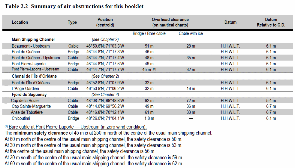
LIST OF LIGHTS, BUOYS AND FOG SIGNALS CORRECTIONS
NEWFOUNDLAND |
||||||||||
1 H444 |
Cape Race |
46 39 30.9 53 04 25 |
Fl |
W |
7.5s |
51.8 |
27 |
White cylindrical tower, red upper portion. 20.7 |
Flash 0.25 s; eclipse 7.25 s. Year round. Horn - Blast 3 s; sil. 3 s; blast 3 s; sil. 51 s. Horn points 135°. Chart:4844 Edn 03/11 |
|
39.1 |
Big Shoal light and bell buoy E9 |
NW. of Bordeaux Island. 47 45 21.5 54 04 15.6 |
Fl |
G |
4s |
..... |
..... |
Green, marked "E9". |
Year round. Chart:4839 Edn 03/11(N10-16) |
|
44.8 |
Buffett Bank light and bell buoy E3 |
E. of harbour. 47 31 56.5 54 01 45.7 |
Fl |
G |
4s |
..... |
..... |
Green, marked "E3". |
Year round. Chart:4617 Edn 03/11(N10-016) |
|
53.4 |
Petit Forte light buoy PE7 |
47 23 46.1 54 39 51.7 |
Q |
G |
1s |
..... |
..... |
Green spar, marked "PE7". |
Year round. Chart:4615 Edn 03/11(N10-016) |
|
63 |
Stanley Rocks light and bell buoy PS1 |
E. of Red Land Cove. 47 14 47.5 54 59 04.8 |
Fl |
G |
4s |
..... |
..... |
Green, marked "PS1". |
Year round. Chart:4624 Edn 03/11(N10-016) |
|
70 |
Shalloway Island, Burin light buoy PB2 |
46 59 49.2 55 10 59.8 |
Fl |
R |
4s |
..... |
..... |
Red, marked "PB2". |
Year round. Chart:4616 Edn 03/11(N10-016) |
|
73.8 |
Vestal Rock light buoy PK4 |
Great Lawn. 46 54 32.9 55 32 38 |
Fl |
R |
4s |
..... |
..... |
Red spar, marked "PK4". |
Year round. Chart:4625 Edn 03/11(N10-016) |
|
136.9 |
François Entrance light and bell buoy QL4 |
47 33 47 56 44 24.4 |
Fl |
R |
4s |
..... |
..... |
Red, marked "QL4". |
Year round. Chart:4633 Edn 03/11(N10-016) |
|
137.23 |
Lower Rock South Cardinal light buoy QLC |
S. of New Harbour. 47 34 50.4 56 38 57.8 |
Q (6) + LFI |
W |
15s |
..... |
..... |
Yellow and black spar, marked "QLC". |
Year round. Chart:4633 Edn 03/11(N10-016) |
|
139.1 |
Penguin Island North Cardinal light and whistle buoy QLE |
47 23 41.4 56 56 55.6 |
Q |
W |
1s |
..... |
..... |
Black and yellow, marked "QLE". |
Year round. Chart:4633 Edn 03/11(N10-016) |
|
139.2 |
Penguin Island West Cardinal light and whistle buoy QLW |
E. of island. 47 23 03.3 57 00 53.9 |
Q(9) |
W |
15s |
..... |
..... |
Yellow, black and yellow, marked "QLW". |
Year round. Chart:4633 Edn 03/11(N10-016) |
|
162.5 |
Graveyard Point Breakwater light buoy QP3 |
Port Aux Basques. 47 34 25.2 59 07 46.8 |
Fl |
G |
4s |
..... |
..... |
Green, marked "QP3". |
Year round. Chart:4641 Edn 03/11(N11-004) |
|
216.12 |
St. Barbe Inner light buoy XB3 |
51 12 27.8 56 46 17.5 |
Fl |
G |
4s |
..... |
..... |
Green spar, marked "XB3". |
Year round. Chart:4667 Edn 03/11(N10-016) |
|
230.5 |
L'Anse au Diable light buoy ND2 |
51 33 25.2 56 45 35.5 |
Fl |
R |
4s |
..... |
..... |
Red spar, marked "ND2". |
Seasonal. Chart:4020 Edn 03/11(N10-016) |
|
235.2 |
Butter Rock light buoy KQB |
Quirpon Harbour Entrance. 51 34 51.8 55 26 29.5 |
Fl(2) |
W |
10s |
..... |
..... |
Black, red and black spar, marked "KQB". |
Seasonal. Chart:4512 Edn 03/11(N10-016) |
|
235.3 |
Brehat Shoal South Cardinal light buoy KQG |
51 25 09.4 55 26 06.5 |
Q(6) +LFl |
W |
15s |
..... |
..... |
Yellow and black, marked "KQG". |
Seasonal. Chart:4020 Edn 03/11(N10-016) |
|
251.5 |
Marten's Rock light buoy KR2 |
Entrance to Chimmey Bay. 50 45 22.7 56 09 14.9 |
Fl |
R |
4s |
..... |
..... |
Red spar, marked "KR2". |
Seasonal. Chart:4538 Edn 03/11(N10-016) |
|
270.92 |
Brandies Shoal light buoy NA5 |
Northern Ships Run. 52 32 40.2 56 02 19.2 |
Fl |
G |
4s |
..... |
..... |
Green spar, marked "NA5". |
Seasonal. Chart:5179 Edn 03/11(N10-016) |
|
284.351 |
Packs Harbour Approaches light buoy NX2 |
53 51 12.9 56 59 11.5 |
Fl |
R |
4s |
..... |
..... |
Red spar, marked "NX2". |
Seasonal. Chart:5134 Edn 03/11(N10-016) |
|
284.4 |
Crab Head light buoy NC2 |
53 44 51.6 56 55 01.8 |
Fl |
R |
4s |
..... |
..... |
Red spar, marked "NC2". |
Seasonal. Chart:5138 Edn 03/11(N10-016) |
|
324.6 |
Fairway Rocks South Cardinal light buoy NN |
Stratacona Run. 56 31 53 60 47 08.5 |
VQ(6) +LFl |
W |
10s |
..... |
..... |
Yellow and black, marked "NN". |
Seasonal. Chart:5052 Edn 03/11(N10-016) |
|
341.496 |
Bear Cove Head light buoy DR3 |
49 29 22.1 55 47 50.5 |
Fl |
G |
4s |
..... |
..... |
Green spar, marked "DR3". |
Seasonal Chart:4593 Edn 03/11(N10-016) |
|
344.8 |
Long Island Rock light buoy DDW1 |
Osmonton Arm. 49 28 44.8 55 22 08.2 |
Fl |
G |
4s |
..... |
..... |
Green spar, marked "DDW1". |
Seasonal. Chart:4864 Edn 03/11(N11-003) |
|
347.2 |
Long Island Outer Shoal light buoy DBE1 |
49 29 07 55 01 13.9 |
Q |
G |
1s |
..... |
..... |
Green spar, marked "DBE1". |
Seasonal. Chart:4595 Edn 03/11(N10-016) |
|
383.9 |
Joe Batts Arm light buoy DJ1 |
Off Fogo Island. 49 44 41.2 54 10 26.5 |
Fl |
G |
4s |
..... |
..... |
Green spar, marked "DJ1". |
Seasonal. Chart:4820 Edn 03/11(N10-016) |
|
465.8 |
Quarry Rock light buoy TV4 |
48 05 21.7 53 42 26.9 |
Fl |
R |
4s |
..... |
..... |
Red spar, marked "TV4". |
Seasonal. Chart:4852 Edn 03/11(N10-016) |
|
466.92 |
New Harbour (Middle) light buoy TN4 |
47 35 29.9 53 33 12.9 |
Fl |
R |
4s |
..... |
..... |
Red spar, marked "TN4". |
Seasonal. Chart:4851 Edn 03/11(N10-016) |
|
ATLANTIC |
||||||||||
343 H3781 |
Upper Port La Tour |
Outer end of E. breakwater. 43 30 19.6 65 28 11 |
LFl |
R |
6s |
7.3 |
5 |
Pipe Swing Pole, red and white triangular daymark red triangle in center. 6.8 |
Operates at night only. Year round. Chart:4241 Edn 03/11 (F11-035) |
|
373.5 H3758 |
Osborne Harbour |
On outer end of wharf. 43 42 52.6 65 06 33.6 |
LFl |
R |
6s |
4.6 |
5 |
Pipe Swing Pole, red and white triangular daymark red triangle in center. 3.8 |
Operates at night only. Year round. Chart:4209 Edn 03/11 (F11-025) |
|
598 H3542 599 H3542.1 |
Sheet Harbour Passage range |
| | | | | | | | |
E. of Kirby River. 44 51 30 62 26 56 343°28' 278.3m from front. |
F F |
W W |
..... ..... |
15.8 19.8 |
18 18 |
White square tower, red vertical stripe. 5.5 White square tower, red vertical stripe. 9 |
Visible in line of range. Operates at night only. Year round. Visible in line of range. Operates at night only. Year round. Chart:4235 Edn 03/11 (F11-026) |
662.2 |
Dover Bay light buoy PQ6 |
45 16 26.2 61 01 03 |
Fl |
R |
4s |
..... |
..... |
Red spar, marked "PQ6". |
Year round. Chart:4233 Edn 03/11 (G10-245) |
|
662.91 H3472 |
Dover Harbour light buoy PQ12 |
45 16 51.7 61 01 34.9 |
Fl |
R |
4s |
..... |
..... |
Red spar, marked "PQ12". |
Year round. Chart:4233 Edn 03/11 (G10-243) |
|
682 |
Canso Harbour light and whistle buoy PC |
N. entrance to harbour. 45 22 14.1 60 59 50.2 |
Mo(A) |
W |
6s |
..... |
..... |
Red and white vertical stripes, marked "PC". |
Year round. Chart:4281 Edn 03/11 (G11-024) |
|
686.5 |
Chedabucto Bay light buoy CF |
45 23 54.3 61 03 00.6 |
Mo(A) |
W |
6s |
..... |
..... |
Red and white vertical stripes, marked "CF". |
Year round. Chart:4307 Edn 03/11 (G11-025) |
|
686.7 |
Chedabucto Bay light buoy C2 |
45 25 38.1 61 06 17.3 |
Q |
R |
1s |
..... |
..... |
Red, marked "C2". |
Year round. Chart:4308 Edn 03/11 (G11-026) |
|
686.8 |
Chedabucto Bay light buoy CGB |
45 28 24.3 61 10 23.7 |
Mo(A) |
W |
6s |
..... |
..... |
Red and white vertical stripes, marked "CGB". |
Year round. Chart:4307 Edn 03/11 (G11-027) |
|
687.1 |
Argos Shoal light buoy CS1 |
45 29 11.3 61 12 16.6 |
Q |
G |
1s |
..... |
..... |
Green, marked "CS1". |
Year round. Chart:4307 Edn 03/11 (G11-028) |
|
687.2 |
Chedabucto Bay light and bell buoy C7 |
45 28 07.2 61 10 49.8 |
Fl |
G |
4s |
..... |
..... |
Green, marked "C7". |
Year round. Chart:4307 Edn 03/11 (G11-029) |
|
687.3 |
Chedabucto Bay light and bell buoy C8 |
45 28 42.3 61 09 55.6 |
Fl |
R |
4s |
..... |
..... |
Red, marked "C8". |
Year round. Chart:4307 Edn 03/11 (G11-030) |
|
687.4 |
Chedabucto Bay light buoy C10 |
45 30 40.3 61 12 18.6 |
Fl |
R |
4s |
..... |
..... |
Red, marked "C10". |
Year round. Chart:4306 Edn 03/11 (G11-031) |
|
687.5 |
Chedabucto Bay light and bell buoy C11 |
45 31 48.3 61 14 17.6 |
Fl |
G |
4s |
..... |
..... |
Green, marked "C11". |
Year round. Chart:4306 Edn 03/11 (G11-032) |
|
687.7 |
Chedabucto Bay light buoy C13 |
45 32 17.8 61 15 28.6 |
Q |
G |
1s |
..... |
..... |
Green, marked "C13". |
Year round. Chart:4306 Edn 03/11 (G11-033) |
|
687.8 |
Chedabucto Bay light buoy C14 |
45 32 37.3 61 15 45.6 |
Fl |
R |
4s |
..... |
..... |
Red, marked "C14". |
Year round. Chart:4306 Edn 03/11 (G11-034) |
|
688 |
Chedabucto Bay light buoy C16 |
45 32 31.3 61 17 30.6 |
Q |
R |
1s |
..... |
..... |
Red, marked "C16". |
Year round. Chart:4306 Edn 03/11 (G11-035) |
|
688.4 |
Chedabucto Bay light buoy C20 |
45 33 44.3 61 19 57.6 |
Q |
R |
1s |
..... |
..... |
Red, marked "C20". |
Year round. Chart:4306 Edn 03/11 (G11-036) |
|
709 |
Cerberus Rock light and whistle buoy CH4 |
S. of rock. 45 27 37 61 06 15 |
Fl |
R |
4s |
..... |
..... |
Red, marked "CH4". |
Year Round. Chart:4308 Edn 03/11 (G11-037) |
|
710 |
Petit-de-Grat light and whistle buoy CJ |
45 28 18.3 60 58 15.6 |
Mo(A) |
W |
6s |
..... |
..... |
Red and white vertical stripes, marked "CJ". |
Year Round. Chart:4308 Edn 03/11 (G11-038) |
|
711 |
Petit-de-Grat light and bell buoy CJ1 |
45 28 59.4 60 58 26.9 |
Fl |
G |
4s |
..... |
..... |
Green, marked "CJ1". |
Year Round. Chart:4308 Edn 03/11 (G11-039) |
|
718 H3399 719 H3399.1 |
Petit-de-Grat Inner range |
| | | | | | | | | | | |
E. side of island. 45 30 03.6 60 57 31.5 033°56' 64.1m from front. |
F F |
G G |
..... ..... |
12.0 15.4 |
16 15 |
Triangular skeleton tower, enclosed lower portion, white trapezoid daymark, red vertical stripe. 3.7 Triangular skeleton tower, enclosed lower portion, white trapezoid daymark, red vertical stripe. 3.4 |
Visible in line of range. Operates at night only. Year round. Visible in line of range. Operates at night only. Year round. Chart:4308 Edn 03/11 (G11-049) |
723 |
Orpheus Rock light and bell buoy NQ1 |
E. side of Rock. 45 28 41.3 60 51 00.6 |
Fl |
G |
4s |
..... |
..... |
Green, marked "NQ1". |
Year Round. Chart:4308 Edn 03/11 (G11-040) |
|
724 |
Petite Anse light and bell buoy NS1 |
45 29 39.3 60 54 55.3 |
Fl |
G |
4s |
..... |
..... |
Green, marked "NS1". |
Year Round. Chart:4308 Edn 03/11 (G11-041) |
|
727 |
Beak Point Shoal (Petit Nez) light and whistle buoy NQ3 |
Off E. side of shoal. 45 33 08.9 60 50 59.6 |
Fl |
G |
4s |
..... |
..... |
Green, marked "NQ3". |
Year Round. Chart:4308 Edn 03/11 (G11-042) |
|
735 |
Haddock Rock light and bell buoy NP2 |
W. of rock. 45 35 50.2 60 49 37.4 |
Fl |
R |
4s |
..... |
..... |
Red, marked "NP2". |
Year Round. Chart:4275 Edn 03/11 (G11-043) |
|
736 |
Lower L'Ardoise light and whistle buoy NM |
N. of Red Point. 45 34 49.2 60 45 52.4 |
Mo(A) |
W |
6s |
..... |
..... |
Red and white vertical stripes, marked "NM". |
Year Round. Chart:4275 Edn 03/11 (G11-044) |
|
784 H764 785 H764.1 |
Sydney South Arm range |
| | | | | | | | | |
Near N. extremity of point. 46 09 26.8 60 12 12.4 162°32' 151.1m from front. |
F F |
G G |
..... ..... |
8 16.1 |
12 15 |
Triangular skeleton tower, white trapezoid daymark, red vertical stripe. 6.7 Triangular skeleton tower, white trapezoid daymark, red vertical stripe. 13.1 |
Visible in line of range. Year round. Visible in line of range. Year round. Chart:4266 Edn 03/11 (G11-052) |
810.7 H796 810.8 H796.1 |
MacFarlane Point range |
| | | | | | | | | |
46 07 34.1 60 36 15.1 065°15' 277.2m from front. |
F F |
Y Y |
..... ..... |
18.0 31.0 |
17 15 |
Triangular skeleton tower, white trapezoid daymark, red vertical stripe. 9.7 Triangular skeleton mast, white trapezoid daymark, red vertical stripe. 10.2 |
Visible in line of range. Seasonal. Visible in line of range. Seasonal. Chart:4277 Edn 03/11 (G11-050) |
843 H843 |
Helens Island |
W. from Sandys Point. 45 39 58.2 60 51 21.1 |
Fl |
G |
4s |
7.5 |
4 |
Triangular skeleton tower. 6.6 |
Operates at night only. Seasonal. Chart:4275 Edn 03/11 (G11-001) |
|
844 H856 |
Ciboux Island |
Northern end of island. 46 23 06.4 60 22 25.8 |
LFl |
R |
12s |
27.2 |
7 |
White cylindrical tower, two red horizontal bands. 9.9 |
Flash 2 s; eclipse 10 s. Operates at night only. Year round. Chart:4367 Edn 03/11 (G11-051) |
|
868.5 |
Grand Étang Northeast Breakwater |
46 33 03.9 61 02 46.5 |
Q |
G |
1s |
8.5 |
4 |
Cylindrical mast. 5.0 |
Operates at night only. Seasonal. Chart:4449 Edn 03/11 (G11-048) |
|
916.3 H1270 916.35 H1270.1 |
Caribou Harbour Inner range |
| | | | | | | | | |
45 44 23 62 41 15.8 209°31' 82.7m from front. |
Iso Iso |
G G |
1s 4s |
6.5 9.5 |
4 4 |
Square skeleton tower, white trapezoid daymark, red vertical stripe. 3.1 Square skeleton tower, white trapezoid daymark, red vertical stripe. 6.2 |
Visible in line of range. Operates at night only. Seasonal. Visible in line of range. Operates at night only. Seasonal. Chart:4483 Edn 03/11 (G11-009) |
1035 |
Skinners Pond |
N. end of S. breakwater. 46 57 58 64 07 33.5 |
Fl |
R |
4s |
4.4 |
3 |
Cylindrical mast. 2.8 |
Flash 1 s; eclipse 3 s. Operates at night only. Seasonal. Chart:4906 Edn 03/11 (G10-232) |
|
1035.5 |
Skinners Pond North Breakwater |
On outer end of N. breakwater. 46 57 59.2 64 07 33.1 |
Fl |
G |
4s |
4.2 |
4 |
Cylindrical mast. 3.2 |
Flash 0.5 s; eclipse 3.5 s. Operates at night only. Seasonal. Chart:4906 Edn 03/11 |
|
1039 1039.1 |
North Lake Harbour range |
| | | | | | | | | |
On outer end of E. breakwater. 46 28 06.9 62 04 05.1 204°34' 328.5m from front. |
Iso Iso |
G G |
1s 4s |
7.5 14.5 |
11 15 |
Square skeleton tower, white trapezoid daymark, red vertical stripe. 5.0 Square skeleton tower, white trapezoid daymark, red vertical stripe. 11.0 |
Visible in line of range. Operates at night only. Seasonal. Visible in line of range. Operates at night only. Seasonal. Chart:4023 Edn 03/11 (G11-012) |
1049.13 |
Grand Tracadie light buoy JH7/7 |
46 24 59.4 63 02 24 |
Fl |
G |
4s |
..... |
..... |
Green, marked "JH7/7". |
Seasonal. Chart:4425 Edn 03/11 (G11-047) |
|
1082.1 |
Northport Breakwater |
Outer end of breakwater. 46 47 38.9 64 03 35.2 |
Fl |
W |
3s |
6 |
2 |
Cylindrical mast. 2.6 |
Privately maintained. Operates at night only. Seasonal. Chart:4492 Edn 03/11 (G10-204) |
|
1145 1146 |
South Richibucto Beach Inner range |
| | | | | | | | | |
On W. end of South Richibucto Beach. 46 42 29.5 64 48 02 065°44' 296.2 m from front. |
Iso Iso |
R R |
1s 4s |
7.7 11.3 |
13 15 |
Square skeleton tower, white trapezoid daymark, red vertical stripe. 5.0 Square skeleton tower, white daymark, red vertical stripe. 9.6 |
Visible in line of range. Operates at night only. Seasonal. Visible in line of range. Operates at night only. Seasonal. Chart:4909 Edn 03/11 (G11-007) |
1198.8 H1477 1198.9 H1477.1 |
Moody Point range |
| | | | | | | | | |
47 06 02.1 65 19 28.5 257°24' 1810.4m from front. |
Iso Iso |
Y Y |
1s 4s |
10.3 18.6 |
14 17 |
Triangular skeleton tower, red trapezoid daymark, black vertical stripe. 8.9 Triangular skeleton tower, red trapezoid daymark, black vertical stripe. 13.9 |
Visible in line of range. Operates at night only. Year round. Visible in line of range. Operates at night only. Year round. Chart:4912 Edn 03/11 (G11-013) |
1202.5 H1479 1202.6 H1479.1 |
Oak Point range |
| | | | | | | | | |
47 06 48.9 65 16 30 024°08' 1324.7m from front. |
Iso Iso |
W W |
1s 4s |
8.5 17.1 |
14 17 |
Triangular skeleton tower, red trapezoid daymark, black vertical stripe. 5.5 Triangular skeleton tower, red trapezoid daymark, black vertical stripe. 7.4 |
Visible in line of range. Operates at night only. Year round. Visible in line of range. Operates at night only. Year round. Chart:4912 Edn 03/11 (G11-015) |
1207 H1491 1208 H1491.1 |
Grants Beach range |
| | | | | | | | | |
47 05 02.9 65 22 29.4 278°03' 875.6m from front. |
Iso Iso |
R R |
1s 4s |
21.0 40.8 |
12 16 |
Triangular skeleton tower, red trapezoid daymark, black vertical stripe. 12.9 Triangular skeleton tower, red trapezoid daymark, black vertical stripe. 23.9 |
Visible in line of range. Operates at night only. Year round. Visible in line of range. Operates at night only. Year round. Chart:4912 Edn 03/11 (G11-016) |
1209.5 H1492 1209.6 H1492.1 |
Lower Newcastle range |
| | | | | | | | | |
47 04 31 65 24 35.5 256°15' 467m from front. |
Iso Iso |
W W |
1s 4s |
12.8 21.9 |
14 14 |
Triangular skeleton tower, red trapezoid daymark, black vertical stripe. 5.9 Triangular skeleton tower, red trapezoid daymark, black vertical stripe. 5.9 |
Visible in line of range. Operates at night only. Year round. Visible in line of range. Operates at night only. Year round. Chart:4912 Edn 03/11 (G11-017) |
1209.7 H1494 1209.8 H1494.1 |
Leggett Shoal range |
| | | | | | | | | |
On N. shore of river. 47 04 42.3 65 23 56.7 043°27' 308.8m from front. |
Iso Iso |
R R |
1s 4s |
14 21.4 |
12 16 |
Triangular skeleton tower, red trapezoid daymark, black vertical stripe. 5.7 Triangular skeleton tower, red daymark, black vertical stripe. 5.4 |
Visible in line of range. Operates at night only. Year round. Visible in line of range. Operates at night only. Year round. Chart:4912 Edn 03/11 (G11-018) |
1212.5 H1496 1212.6 H1496.1 |
Millbank range |
| | | | | | | | | |
47 03 21.8 65 27 34 252°26' 305.6m from front. |
Iso Iso |
R R |
1s 4s |
16.1 31.1 |
11 16 |
Triangular skeleton tower, red trapezoid daymark, black vertical stripe. 6.0 Triangular skeleton tower, red trapezoid daymark, black vertical stripe. 12.0 |
Visible in line of range. Operates at night only. Year round. Visible in line of range. Operates at night only. Year round. Chart:4912 Edn 03/11 (G11-019) |
1218 H1507 1219 H1507.1 |
Newcastle range |
| | | | | | | | | |
47 00 58 65 32 46 278°33' 49m from front. |
Iso Iso |
Y Y |
1s 4s |
12.9 16.2 |
13 13 |
Triangular skeleton tower, red trapezoid daymark, black vertical stripe. 4.3 Triangular skeleton tower, red trapezoid daymark, black vertical stripe. 6.9 |
Visible in line of range. Operates at night only. Year round. Visible in line of range. Operates at night only. Year round. Chart:4912 Edn 03/11 (G11-020) |
1294 1295 |
Baie de Lamèque South range |
| | | | | | | | | |
On shore, S. side of bay. 47 46 47.6 64 39 09 074°14' 820.4m from front. |
Iso Iso |
Y Y |
1s 4s |
5.0 11.1 |
14 16 |
Square skeleton tower, white trapezoid daymark, red vertical stripe. 5.0 Square skeleton tower, white trapezoid daymark, red vertical stripe. 9.6 |
Visible in line of range. Operates at night only. Seasonal. Visible in line of range. Operates at night only. Seasonal. Chart:4913 Edn 03/11 (G11-022) |
1296 1297 |
Lamèque range |
| | | | | | | | | |
On end of wharf extension. 47 47 26 64 39 31.9 041°43' 118.6m from front. |
Iso Iso |
R R |
1s 4s |
9.4 12.5 |
6 7 |
Square skeleton tower, white trapezoid daymark, red vertical stripe. 8.2 Square skeleton tower, white trapezoid daymark, red vertical stripe. 11.3 |
Visible in line of range. Operates at night only. Seasonal. Visible in line of range. Operates at night only. Seasonal. Chart:4920 Edn 03/11 (G11-023) |
1394 |
Anse à l'Îlot |
South end of Marina de Chandler jetty. 48 20 38.1 64 40 09.2 |
Fl |
Y |
4s |
7.0 |
4 |
Mast. 5.0 |
Flash 0.5 s; eclipse 3.5 s. Operates at night only. Privately maintained by the Municipality of Chandler. Year round. Chart:4921 Edn 03/11 (Q10-150) |
|
1497 H914 1498 H914.1 |
Cap-aux-Meules, Quai range |
| | | | | | | | | |
47 22 36.8 61 51 13.2 330°13' 133.2m from front. |
Iso Iso |
G G |
1s 1s |
6.8 12.0 |
13 13 |
Square skeleton tower, orange trapezoid daymark, black vertical stripe. 4.6 Square skeleton tower, orange trapezoid daymark, black vertical stripe. 9.2 |
Visible in line of range. Operates at night only. Year round. Visible in line of range. Operates at night only. Year round. Chart:4956 Edn 03/11 (Q10-164, 165) |
1505 H909 1506 H909.1 |
Havre-Aubert range |
| | | | | | | | | |
47 13 43.1 61 49 59.6 213°31' 540.6m from front. |
Iso Iso |
G G |
1s 4s |
5.0 13.2 |
16 16 |
Red square skeleton tower, orange trapezoid daymark, black vertical stripe. 4.9 Red square skeleton tower, orange daymark, black vertical stripe. 4.6 |
Visible in line of range. Operates at night only. Year round. Visible in line of range. Operates at night only. Year round. Chart:4957 Edn 03/11 (Q10-146, 166) |
1779 H2112 1779.1 1780 H2112.1 |
Pointe Noire, Saguenay range |
| | | | | | | | | |
On E. extremity of point. 48 07 23.9 69 43 00.4 273°05' 427.4m from front. |
F F F |
W G W |
..... ..... ..... |
29.1 28.8 43.5 |
22 6 22 |
Square squeleton tower, orange trapezoid daymark, black vertical stripe. 11.4 11.0 Skeleton tower, orange trapezoid daymark, black vertical stripe. 9.1 |
Visible in line of range. Emergency light. Year round. Visible from 077° through E. and S. to 257°. Visible in line of range. Emergency light. Year round. Chart:1203 Edn 03/11 (Q11-003, 004, 005) |
1852 H2218 1852.1 1853 H2218 1853.1 |
Cap-aux-Corbeaux range |
| | | | | | | | | | | | | | | | | | |
E. of wharf. 47 26 06.7 70 25 40.6 024°13' 374.6m from front. |
F F F F |
W W W W |
..... ..... ..... ..... |
32.9 32 52.4 52.0 |
17 8 17 8 |
Skeleton tower, orange trapezoid daymark, black vertical stripe. 32.2 31.4 Skeleton tower, orange trapezoid daymark, black vertical stripe. 13.0 12.8 |
Emergency light. Year round. 2nd light - Visible from eastward Emergency light. Year round. 2nd light - Visible from eastward. Chart:1233 Edn 03/11 (Q11-015, 016) |
1985 H2340 1986 H2340.1 1986.1 |
Sainte-Croix range |
| | | | | | | | | |
E. of Sainte-Croix wharf. 46 37 40.6 71 41 58.5 117°02' 483.9m from front. |
F F F |
W W G |
..... ..... ..... |
60.0 75.1 74.7 |
20 20 6 |
Skeleton tower, orange rectangular daymark, black vertical stripe. 7.6 Square skeleton tower, orange rectangular daymark. 15.6 |
Visible in line of range. Emergency light. Year round. Visible in line of range. Emergency light. Year round. 2nd light - Visible eastward of 137°. Operates at night only. Chart:1315 Edn 03/11 (Q11-017) |
2155 |
Îlets light buoy |
Delete from list. Chart:1312 Edn 03/11 (Q11-010) |
||||||||
2156 |
Rivière Saint-François Channel Entrance light buoy SJ2 |
Delete from list. Chart:1312 Edn 03/11 (Q11-023) |
||||||||
2168 H2416 2169 H2416.1 |
Île des Barques range |
|| | | | | | | | | |
On E. end of island. 46 05 15.3 72 59 41.8 218°25' 479.6m from front. |
F F |
G G |
..... ..... |
11.4 28.5 |
13 13 |
Block tower, orange trapezoidal daymark, black vertical stripe. 4.0 Square skeleton tower, orange trapezoid daymark, black vertical stripe. 20 |
Emergency mode. Visible in line of range. Operates at night only. Year round. Emergency mode. Visible in line of range. Operates at night only. Year round. Chart:1312 Edn 03/11 (Q11-010) |
2172.50 |
Île des Barques light buoy S121 |
46 05 13.5 73 00 07.2 |
Fl |
G |
4s |
..... |
..... |
Green spar, marked "S121". |
Experimental spar. Year round. Chart:1312 Edn 03/11 (Q10-162) |
|
2330 H2482 2331 H2482.1 |
Île Deslauriers range |
| | | | | | | | | |
E. side of island. 45 42 44.8 73 26 22.8 217°32' 2653.3m from front. |
Iso Iso Iso |
G G G |
1s 1s 2s |
10.7 31.9 2.5 |
14 14 4 |
Square Skeleton tower, orange trapezoid daymark, black vertical stripe. 6.6 Trapezoidal skeleton tower, orange trapezoid daymark, black vertical stripe. 26.0 |
Visible in line of range. Operates at night only. Year round. Visible in line of range. Operates at night only. Year round. Visible 360°. Operates at night only. Chart:1310 Edn 03/11 (Q10-169, 170) |
INLAND WATERS |
||||||||||
8.2 |
Pointe Johnson Direction |
45 24 03.1 73 44 44.5 |
Iso |
Y |
1s |
7.8 |
15 |
White mast, orange rectangular daymark. 6.0 |
Visible on a bearing of 248°30'. Operates at night only. Seasonal. Chart:1430 Edn 03/11(Q11-001) |
|

