
Archived information
The Standard on Web Usability replaces this content. This content is archived because Common Look and Feel 2.0 Standards have been rescinded.
Archived information is provided for reference, research or recordkeeping purposes. It is not subject to the Government of Canada Web Standards and has not been altered or updated since it was archived.
NOTICES TO MARINERS
PUBLICATION
EASTERN EDITION

Safety First, Service Always
Published Monthly by the
CANADIAN COAST GUARD
www.notmar.gc.ca/subscribe/
CONTENTS
| Section 1 | General and Safety Information |
| Section 2 | Chart Corrections |
| Section 3 | Radio Aids to Marine Navigation Corrections |
| Section 4 | Sailing Directions and Small Craft Guide Corrections |
| Section 5 | List of Lights, Buoys and Fog Signals Corrections |
Canadian Coast Guard Programs
Aids to Navigation and Waterways
Fisheries and Oceans Canada
Montreal, Quebec
H2Y 2E7
© Her Majesty the Queen in Right of Canada, 2017
DFO/2017-2002
Fs152-6E-PDF
ISSN 1719-7708
Disponible en français :
Publication des Avis aux navigateurs
Édition de l'Est
Édition mensuelle Nº09/2017
Fisheries and Oceans Canada
Official Publication of the Canadian Coast Guard
DFO/2018-2002
EXPLANATORY NOTES
Geographical positions refer directly to the graduations of the largest scale Canadian Hydrographic chart unless otherwise indicated.
Bearings refer to the true compass and are measured clockwise from 000° (North) clockwise to 359°; those relating to lights are from seaward.
Visibility of lights is that in clear weather.
Depths - The units used for soundings (metres, fathoms or feet) are stated in the title of each chart.
Elevations are normally given above Higher High Water, Large Tide unless otherwise indicated.
Distances may be calculated as follows:
1 nautical mile = 1,852 metres (6,076.1 feet)
1 statute mile = 1,609.3 metres (5,280 feet)
1 metre = 3.28 feet
Temporary & Preliminary Notices are indicated by a (T) or a (P) in Section 1, respectively. Please note that Nautical charts are not amended by the Canadian Hydrographic Service for Temporary (T) and Preliminary (P) Notices. It is recommended that mariners chart these corrections in pencil. The list of charts affected by Temporary and Preliminary Notices are revised and promulgated quarterly in Section 1 of the Monthly Edition.
Please note that, in addition to the temporary and preliminary changes normally advertised as (T) and (P) Notices, there are a few permanent changes to aids to navigation that have been advertised as Preliminary Notices to Mariners while charts are being updated for new editions.
Marine Information Report & Suggestion Sheet
Mariners are requested to notify the responsible authorities when new or suspected dangers to navigation are discovered, changes observed in aids to navigation or corrections to publications are seen
to be necessary. Such communications can be made using the Marine Information Report & Suggestion Sheet inserted on the last
page of each monthly edition of Notices to Mariners.
Canadian Hydrographic Service - Information Published in Section 2 of Notices to Mariners
Mariners are advised that only the most critical changes that directly affect safety to navigation are issued in Section 2 – Chart Corrections. This limitation
is required to ensure that charts remain as clear and easy to read as possible. As a result, mariners may see minor discrepancies of a
non-critical nature between information in official publications. For example, a small change in the nominal range or focal height of a light
may not result in the production of a chart correction in Notices to Mariners, but may result in a correction in the List of Lights, Buoys and
Fog Signals publication.
In case of discrepancy between information provided on CHS charts relating to aids to navigation, and the List of Lights, Buoys and Fog Signals publication, the latter shall be deemed as containing the most up-to-date information.
Canadian Nautical Charts & Publications
A source list of Canadian nautical charts and publications is published in Notice No. 14 of the Notices to Mariners Annual Edition 2018. The source supply and the prices
effective at the time of printing are listed. For current chart edition dates, please refer to the following website:
www.chs-shc.gc.ca/charts-cartes/paper-papier/index-eng.asp
CHART CORRECTIONS - SECTION 2
Corrections to nautical charts will be listed in numerical order by chart number. Each chart correction listed applies only to that particular chart. Related charts, if any, will have their own specific correction listed separately.
Users should also refer to CHS Chart 1: Symbols, Abbreviations and Terms for additional information pertaining to the correction of charts.
The illustration below describes the elements that will comprise a typical Section 2 chart correction:

The last correction number is identified with the LNM/D or Last Notice to Mariners Number / Date.
NOTICES TO MARINERS WEBSITE – MONTHLY EDITIONS, CHART CORRECTIONS, AND CHART PATCHES
The Notices to Mariners website allows users to access the monthly publications,
chart corrections, and chart patches.
Users can subscribe for free to the email notification service
to receive notifications when charts of interest are updated, including their patches, as well as when a new monthly edition becomes available online.
ADVISORY NOTICES TO SHIPPING (BROADCAST AND WRITTEN)
The Canadian Coast Guard is implementing a number of changes to the aids to navigation system in Canada.
These changes are advertised as Notices to Shipping (Broadcast and Written) by the Canadian Coast Guard, and are then followed up with Notices to Mariners, then charts are updated by hand correction, reprints or new editions.
Mariners are advised that all relevant Written Notices to Shipping should be kept until superseded by Notices to Mariners or through revised charts issued by the Canadian Hydrographic Service (CHS).
Written Notices to Shipping are available on the Canadian Coast Guard website at: www.ccg-gcc.gc.ca/eng/CCG/NOTSHIP.
The Canadian Hydrographic Service is reviewing the impact of these changes with the Canadian Coast Guard and together are preparing an action plan on the issuing of chart revisions.
For further information, contact your local Regional Notices to Shipping (NOTSHIP) issuing authorities.
Newfoundland
* Port aux Basques MCTS Centre
Canadian Coast Guard
49 Stadium Rd.
P.O. Box 99
Port aux Basques, NL A0M 1C0
Telephone: (709) 695-2168 or 1-800-563-9089
Facsimile: (709) 695-7784
Email: notshippax@dfo-mpo.gc.ca
Website: http://www.ccg-gcc.gc.ca/eng/CCG/Notship#nfld
Central & Arctic
* Prescott MCTS Centre
Canadian Coast Guard
401 King Street West
P.O. Box 1000
Prescott, ON K0E 1T0
“C” Series NOTSHIPs
Telephone: (613) 925-0666
Facsimile: (613) 925-4519
Email: CA.XCA-NotshipDesk@dfo-mpo.gc.ca
Website: http://www.ccg-gcc.gc.ca/eng/CCG/Notship-Home
Maritimes
* Sydney MCTS Centre
Canadian Coast Guard
1190 Westmount Road
Sydney, NS B1R 2J6
Telephone: (902) 564-7751 or 1-800-686-8676
Facsimile: (902) 564-7662
Email: notshipssyd@mar.dfo-mpo.gc.ca
Website: http://www.ccg-gcc.gc.ca/eng/CCG/Notship#maritime
Québec
* Les Escoumins MCTS Centre
Canadian Coast Guard
35, rue Otis
Les Escoumins, QC G0T 1K0
Telephone: (418) 233-2308
Facsimile: (418) 233-3299
Email: opsavis@dfo-mpo.gc.ca
Website: www.marinfo.gc.ca/en/avisecrits/index.asp
* Iqaluit MCTS Centre
Operational from approximately mid-May until late December.
Canadian Coast Guard
P.O. Box 189
Iqaluit, NU X0A 0H0
“A” Series NOTSHIPs
Telephone: (867) 979-5269
Facsimile: (867) 979-4264
Email: IqaNordreg@innav.gc.ca
Website: http://www.ccg-gcc.gc.ca/eng/CCG/Notship-Home
“H” Series NOTSHIPs
Telephone: (867) 979-0310
Facsimile: (867) 979-4264
Email: Iqamck01@innav.gc.ca
Website: http://www.ccg-gcc.gc.ca/eng/CCG/Notship-Home
* Service available in English and French.
Index
NUMERICAL INDEX OF CANADIAN CHARTS AFFECTED
| 1203 | 4024 | 4530 | 4920 |
| 1221 | 4201 | 4615 | 6430 |
| 1234 | 4236 | 4669 | 6434 |
| 1430 | 4302 | 4905 | 6435 |
| 2123 | 4307 | 4911 | |
| 2181 | 4320 | 4912 | |
| 3983 | 4486 | 4913 |
SECTION 1 - GENERAL AND SAFETY INFORMATION
CANADIAN HYDROGRAPHIC SERVICE – ANNOUNCEMENT REGARDING CHS CHART PATCHES
Colour Web Patches are free to the mariner, and given the quality of many printers, should reproduce well. They will be available in real time all around the world.
CHS welcomes your feedback on this service at chsinfo@dfo-mpo.gc.ca
CANADIAN HYDROGRAPHIC SERVICE – CUMULATIVE CHART CORRECTIONS
The cumulative chart corrections published in Notices to Mariners can now be accessed at
CANADIAN HYDROGRAPHIC SERVICE – CURRENT CHART EDITION DATES
CHART EDITIONS
The three terms described below are used to indicate the publication status of Canadian charts.
NEW CHART - "NEWCHT"
The first publication of a Canadian chart embracing an area not previously charted to the scale shown, or embracing an area different from any existing Canadian chart.
NEW EDITION - "NEWEDT"
A new issue of an existing chart containing amendments essential to navigation in addition to those issued in Notices to Mariners and making existing editions obsolete.
REPRINTS
A new issue of the current edition of a chart incorporating no amendments of navigational significance other than those previously promulgated in Notices to Mariners. It may also contain amendments from other sources provided they are not essential to navigation. Previous printings of the current edition remain in force.
The current chart edition dates can be accessed at www.chs-shc.gc.ca/charts-cartes/paper-papier/index-eng.asp
CANADIAN HYDROGRAPHIC SERVICE – PRINT ON DEMAND CHARTS - CARE AND USE
Background
By providing nautical charts to the public, the goal of the Canadian Hydrographic Service (CHS) is to provide services for safe navigation in a fiscally responsible manner. As a result, CHS continues to expand its portfolio of nautical paper charts that are printed using Print On Demand (POD) technology. These charts are easily recognized by their whiter paper and the coloured logo of the Canadian Hydrographic Service. This new technology enables CHS to print charts in a more efficient manner, while enhancing chart content through being able to quickly add new and important information. POD technology provides customers with up-to-date charts without the historical hand-drawn corrections or glued-on patches. Additionally, this technology eliminates out-of-stock situations which arise with the traditional printing and warehousing methods. In the event of a national emergency, CHS can respond to the appropriate authorities with the best available information very quickly.
Care of Your POD Chart
CHS encourages its customers to handle the POD charts more carefully than the traditional lithographic charts. When plotting information on POD charts, use HB pencils and apply limited pressure. Testing has suggested that an Indian gum eraser is more effective than alternatives when used on the product. This eraser is also suitable for charts printed using lithographic processes.
CANADIAN HYDROGRAPHIC SERVICE, TRANSPORT CANADA – NAVIGATION SAFETY - ECDIS
Mariners are advised that ECDIS may not display some isolated shoal depths when operating in "base or standard display" mode. Route planning and monitoring alarms for these shoal depths may not always be activated. To ensure safe navigation and to confirm that a planned route is clear of such dangers, mariners should visually inspect the planned route and any deviations from it using ECDIS configured to display "all data". The automated voyage planning check function should not be solely relied upon.
TRANSPORT CANADA – RESTRICTED SPEED AREA - ST. CLAIR AND DETROIT RIVERS
Since November 14, 2012, the restricted speed area currently in place as per the St. Clair and Detroit River Navigation Safety Regulations between the Detroit River light and Peche Island light is reduced in size by relocatingthe southern point of the restricted speed area from its current location at the Detroit River light to a new location at Bar Point light D33. (This notice refers to the previous one published in November 2012 with number *1103.)
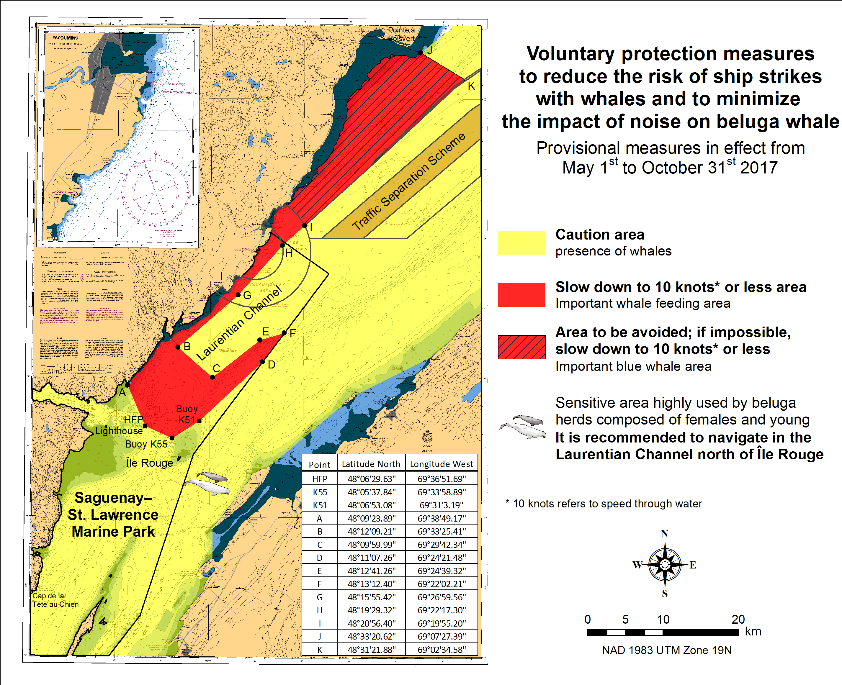
SAGUENAY-ST. LAWRENCE MARINE PARK AND SURROUNDING WATERS – WHALE PROTECTION
The waters in and around the Saguenay–St. Lawrence Marine Park are well known for the resident endangered beluga population and the wide diversity of whales that migrate there to feed, particularly between April and November.
Regulatory protection measures
All whale species that are found in the St. Lawrence are protected under the Marine Mammal Regulations, pursuant to the Fisheries Act. Within the boundaries of the Marine Park, specific measures are set out in the Marine Activities in the Saguenay–St. Lawrence Marine Park Regulations, pursuant to the Act Establishing the Saguenay–St. Lawrence Marine Park. Any collision with a marine mammal within the Marine Park must immediately be reported to a park warden at 1-866-508-9888. For collisions that occur outside the Marine Park or for any situation involving a marine mammal that is dead or in trouble, contact the emergency network at 1-877-722-5346 or on channel 16.
For more information on the Saguenay–St. Lawrence Marine Park, see section 5C of the Notices to Mariners Annual Edition 2017.
Voluntary protection measures
Provisional measures in effect from May 1st to October 31st, 2017. See map below.
These measures apply to merchant vessels and cruise ships between Pointe à Boisvert and Cap de la Tête au Chien to prevent collisions with whales. These measures should only be taken when they will not jeopardize navigational safety.
Caution area (yellow area): To reduce the risk of collisions with whales that can be present anywhere in this area, heightened vigilance of navigators is critical. Posting a lookout is recommended in order to increase the chances of seeing the whales and thus taking necessary measures to avoid them. If bypassing the whales is not possible, slow down and wait for the animals to move away to a distance greater than 400 meters (0.215 nautical miles) before resuming original speed. It is more difficult to see the animals at night therefore increased caution is recommended.
Slow down to 10 knots or less area (red area): To reduce the risk of collisions with whales in this feeding area, it is recommended that vessels slow down to a maximum speed through the water of 10 knots and post a lookout. It is further recommended to remain in the Laurentian Channel to the north of Île Rouge to minimize the impact of noise in a sensitive area south of this island, which is highly frequented by herds of beluga whales composed of females and young.
Area to be avoided (hatched red area): To reduce noise and the risk of collisions with whales, vessels should avoid transiting through this area which is highly frequented by blue whales, an endangered species. If the area cannot be avoided, slow down to a speed through the water of 10 knots or less.
CANADIAN HYDROGRAPHIC SERVICE – MODIFICATIONS TO THE 2017 CANADIAN TIDE AND CURRENT TABLES – VOLUME 3
Mariners should replace the following values for Baie-Trinité, Index no. 2815 published in the 2017 Canadian Tide and Current Tables with the attached table for Baie-Trinité on page 64, Volume 3, 2017 Canadian Tide and Current Tables, St. Lawrence River and Saguenay Fjord.
The Canadian Hydrographic Service of the Quebec Region has recently been informed that there is an error in the 2017 Canadian Tide and Current Tables, Volume 3, St. Lawrence River and Saguenay Fjord, page 64, Index no. 2815 – BAIE-TRINITÉ.
Mariners and users are advised that tidal prediction calculations for the secondary port of Baie-Trinité should be carried out on the reference port of SEPT-ÎLES rather than of Pointe-au-Père. The information and tidal differences for secondary port BAIE-TRINITÉ should be located in the block of stations on SEPT-ÎLES.
The tidal predictions of times and heights of the high and low tides on the website for Baie-Trinité are however correct.
Insert the new part of Table 3 provided in Section 1 of this monthly edition.
https://www.notmar.gc.ca/publications/monthly-mensuel/images/ed052017-part1-tidal-information.pdf
CANADIAN HYDROGRAPHIC SERVICE – MODIFICATION TO CATALOGUE 2: PACIFIC COAST/CÔTE PACIFIQUE
The Canadian Hydrographic Service has been recently informed that there is an error in the following chart catalogue:
Catalogue 2: Pacific Coast/Côte pacifique
Affix patch to Catalogue 2: Pacific Coast/Côte pacifique provided in Section 1 of this monthly edition.
https://www.notmar.gc.ca/publications/monthly-mensuel/images/ed072017-part1-catalogue2-patch.pdf
GOLFE DU SAINT-LAURENT / GULF OF ST. LAWRENCE – SPEED RESTRICTION DUE TO INCREASED PRESENCE OF NORTH ATLANTIC RIGHT WHALES
Reference Chart: 4002
In order to promote navigation safety and protection of the marine environment due to an increased presence of North Atlantic right whales in the Gulf of St. Lawrence, all vessels of 65 feet (19.8m) or longer are instructed to proceed at a speed not exceeding 10.0 knots over the ground in the St. Lawrence River and the Gulf of St. Lawrence between the following coordinates: 47º 10’ N 062º 00’ W; 47º 10’ N 065º 00’ W; 50º 20’ N 065º 00’ W; 50º 20’ N 062º 00’ W.
Failure to comply with this speed restriction could lead to enforcement action under section 7 of the Collision Regulations.
Report all observations of live, dead or injured whales to the Canadian Coast Guard on VHF ch 16 or by calling the Marine Animal Response Society at 1-866-567-6277 or the Réseau québécois d’urgences pour les mammifères marins at 1-877-722-5346. The reporting of live whale sightings using Whale Alert is encouraged as well (http://www.whalealert.org/).
(NOTSHIP M1717/17, Q1189/17)
*901 CANADIAN HYDROGRAPHIC SERVICE – NAUTICAL CHARTS
|
CHARTS |
MAIN TITLE |
SCALE |
PUBLISHED |
CAT# |
PRICE |
|---|---|---|---|---|---|
|
New Charts |
|||||
|
3983 |
Caamaño Sound to/à Principe Channel |
1:40 000 |
26-MAY-2017 |
2 |
20.00 |
|
New Editions |
|||||
|
4201 |
Halifax Harbour: Bedford Basin |
1:10 000 |
25-AUG-2017 |
1 |
20.00 |
*902 CANADIAN HYDROGRAPHIC SERVICE – RASTER DIGITAL CHARTS (BSB V3)
|
CHARTS |
MAIN TITLE |
SCALE |
PUBLISHED |
|---|---|---|---|
|
New Charts |
|||
|
RM-7739 |
James Ross Strait |
1:80 000 |
26-FEB-2016 |
|
New Editions |
|||
|
RM-1220 |
Baie des Sept-Îles |
1:25 000 |
24-MAR-2017 |
|
RM-1436 |
Whaleback Shoal to/au Summerland Group |
1:25 000 |
17-MAR-2017 |
|
RM-2043 |
LOWER NIAGARA RIVER AND APPROACHES / ET LES APPROCHES |
1:20 000 |
29-MAY-2015 |
|
RM-2310 |
Caribou Island to/à Michipicoten Island |
1:97 280 |
29-MAY-2015 |
|
RM-2318 |
Heron Bay |
1:12 161 |
29-MAY-2015 |
|
RM-3598 |
Cape Scott to Cape Calvert |
1:74 490 |
11-NOV-2016 |
|
RM-3625 |
Scott Islands |
1:80 000 |
21-OCT-2016 |
|
RM-3726 |
Laredo Sound and Approaches |
1:72 217 |
07-OCT-2016 |
|
RM-3741 |
Otter Passage to Bonilla Island |
1:72 860 |
09-SEP-2016 |
|
RM-3957 |
Approaches to/Approches à Prince Rupert Harbour |
1:40 000 |
07-OCT-2016 |
|
RM-4276 |
Little Bras D'or |
1:5 000 |
24-FEB-2017 |
|
RM-4363 |
Cape Smoky to / à St Paul Island |
1:75 000 |
24-FEB-2017 |
|
RM-5049 |
Davis Inlet to / aux Seniartlit Islands |
1:60 000 |
25-NOV-2016 |
|
RM-6209 |
Brereton Lake |
1:7 200 |
29-MAY-2015 |
|
RM-6267 |
Grindstone Point to/à Berens River |
1:125 000 |
29-MAY-2015 |
|
RM-7527 |
Erebus and Terror Bay and/et Radstock Bay |
1:50 000 |
29-APR-2016 |
|
RM-7569 |
Barrow Strait and/et Wellington Channel |
1:300 000 |
17-MAR-2017 |
*903 LAC SAINT-LOUIS – UNLIT PRIVATE BUOYS PERMANENTLY DISCONTINUED
Reference Chart: 1430
The following unlit private buoys have been permanently discontinued:
Unlit private buoy Marina Sainte-Anne PRIV (LL 11559) (45° 24’ 06.5”N 073° 56’ 57.0”W)
Unlit private buoy Marina Sainte-Anne PRIV (LL 11560) (45° 24’ 06.3”N 073° 56’ 54.9”W)
(Q2017-029, 030)
*904 CARAQUET HARBOUR, BAIE DE SHIPPEGAN AND / ET MISCOU HARBOUR – UNLIT BUOY REPLACED BY LIT BUOY
Reference Chart: 4913
Fox Dens Gully buoy TK5 (LL 6262.1) (47° 53’ 06.6”N 064° 29’ 58.5”W) has been replaced by
Fox Dens Gully light buoy TK5 (LL 1262.12) (47° 53’ 05.7”N 064° 29’ 58.5”W)
(G2017-089, 090)
*905 PLANS: BAIE DES CHALEURS / CHALEUR BAY: CÔTE SUD / SOUTH SHORE – UNLIT SPAR BUOY REPLACED BY LIT SPAR BUOY
Reference Chart: 4920
Shippegan Gully buoy TJ8 (LL 6248.151) (47° 43’ 00.7”N 064° 39’ 44.7”W) has been replaced by
Shippegan South Gully light buoy TJ8 (LL 1248.151) (47° 42’ 58.7”N 064° 39’ 47.6”W)
(G2017-087, 088, 093)
*906(P) STRAIT OF CANSO – NOTICE OF PROPOSED CHANGES
Reference Chart: 4302
The Canadian Coast Guard proposes to permanently change the following aids to navigation:
|
LL # |
Name of Aid |
Position |
Proposed Changes |
|---|---|---|---|
|
689.3 |
Eddy Point Range Front Light |
45 31 12.2 061 15 07.4 |
Change the colour of the light from yellow to green. Remove locator light. |
|
689.4 |
Eddy Point Range Rear Light |
124°51' 361m from front. |
Change the colour of the light from yellow to green. Remove locator light. |
|
690.3 |
Middle Melford range front |
45 32 21.7 061 18 53.2 |
Change the colour of the light from yellow to green. |
|
690.4 |
Middle Melford range rear |
268°05' 92.4m from front. |
Change the colour of the light from yellow to green. |
|
694.4 |
Cahil Rock range front |
45 34 13.2 061 21 17.5 |
Change the colour of the light from yellow to green. Remove locator light. |
|
694.5 |
Cahil Rock range rear |
304°46' 176.1m from front. |
Change the colour of the light from yellow to green. Remove locator light. |
|
701 |
Balache Point range front |
45 38 57.7 061 24 59.4 |
Change the colour of the light from yellow to red. |
|
702 |
Balache Point range rear |
131°30' 219.8m from front. |
Change the colour of the light from yellow to red. |
|
704 |
Janvrin Island range front |
45 32 31.3 061 12 01.6 |
Change the light from “Operates at night only.” to “Operates 24 h.” |
|
704.1 |
Janvrin Island range rear |
088°10' 300.2m from front. |
Change the light from “Operates at night only.” to “Operates 24 h.” |
Comments on this action are solicited from mariners and other interested parties. Comments should be directed to the following within three months from the date of this notice:
Superintendent, Renee PopeAids to Navigation and WaterwaysCanadian Coast GuardP.O. Box 5667St. John’s, NL, A1C 5X1Telephone: (709) 772-2800Email: renee.pope@dfo-mpo.gc.ca
Any objections raised must state the facts on which they are based and should include supporting information on safety, commerce and public benefit.
(G2017-095)
*907(P) STRAIT OF CANSO – LIGHT TO BE DISCONTINUED
Reference Chart: 4302
The Canadian Coast Guard proposes to permanently discontinue the following aid to navigation:
Bear Head Direction (LL 690) (45º 32’ 53.8”N 061º 17’ 17.6”W)
Comments on this action are solicited from mariners and other interested parties. Comments should be directed to the following within three months from the date of this notice:
Superintendent, Renee PopeAids to Navigation and WaterwaysCanadian Coast GuardP.O. Box 5667St. John’s, NL, A1C 5X1Telephone: (709) 772-2800Email: renee.pope@dfo-mpo.gc.ca
Any objections must state the facts on which they are based and should include supporting information on safety, commerce and public benefit.
(G2017-094P)
*908(P) CANSO HARBOUR TO / AU STRAIT OF CANSO – NOTICE OF PROPOSED CHANGES
Reference Chart: 4307
The Canadian Coast Guard proposes to permanently change the following aids to navigation:
|
LL # |
Name of Aid |
Position |
Proposed Changes |
|---|---|---|---|
|
687.2 |
Chedabucto Bay light and bell buoy C7 |
45 28 07.2 061 10 49.8 |
Remove bell. Buoy and light will remain. |
|
687.3 |
Chedabucto Bay light and bell buoy C8 |
45 28 42.3 061 09 55.6 |
Remove bell. Buoy and light will remain. |
Comments on this action are solicited from mariners and other interested parties. Comments should be directed to the following within three months from the date of this notice:
Superintendent, Renee PopeAids to Navigation and WaterwaysCanadian Coast GuardP.O. Box 5667St. John’s, NL, A1C 5X1Telephone: (709) 772-2800Email: renee.pope@dfo-mpo.gc.ca
Any objections raised must state the facts on which they are based and should include supporting information on safety, commerce and public benefit.
(G2017-095)
*909(P) CAPE TORMENTINE À / TO WEST POINT – RANGE LIGHTS TO BE DISCONTINUED
Reference Chart: 4905
The Canadian Coast Guard intends to permanently discontinue the following aids to navigation:
Chockpish range front (LL 1127.5) (46° 34’ 58.7”N 064° 43’ 21.5”W)
Chockpish range rear (LL 1127.6) (271°02’ 109.5m from front)
Comments on this action are solicited from mariners and other interested parties. Comments should be directed to the following within three months from the date of this notice:
Superintendent, Renee PopeAids to Navigation and WaterwaysCanadian Coast GuardP.O. Box 5667St. John’s, NL, A1C 5X1Telephone: (709) 772-2800Email: renee.pope@dfo-mpo.gc.ca
Any objections raised must state the facts on which they are based and should include supporting information on safety, commerce and public benefit.
(G2017-096P, 097P)
*910 HALIFAX HARBOUR: BEDFORD BASIN – DAYBEACONS PERMANENTLY DISCONTINUED
Reference: Notice 509(P)/13 is cancelled (Chart 4201).
(F2016-060)
*911 CARAQUET HARBOUR, BAIE DE SHIPPEGAN AND / ET MISCOU HARBOUR – LIGHT PERMANENTLY DISCONTINUED
Reference: Notice 111(P)/17 is cancelled (Chart 4913).
(G2017-082)
SECTION 2 - CHART CORRECTIONS
1203 - Tadoussac - New Edition - 17-JUN-2011 - NAD 1983
| 15-SEP-2017 | LNM/D. 21-JUL-2017 | ||
| Add |
private white and orange hazard lighted can buoy Fl Y, Priv (See Chart No. 1, Qs) This notice affects Electronic Navigational Chart: CA379232, CA479053, CA579054 |
48°08′19.3″N 069°42′53.0″W | |
| (Q2017032) LL(1782.5) DFO(6409698-01) |
1221 - Pointe de Moisie à/to Île du Grand Caoui - New Edition - 27-FEB-2015 - NAD 1983
| 22-SEP-2017 | LNM/D. 16-SEP-2016 | ||
| Delete |
Constr (2014) against pier (See Chart No. 1, F32) This notice affects Electronic Navigational Chart: CA379028 |
50°10′07.0″N 066°28′10.0″W | |
| DFO(6409227-01) | |||
| Amend |
pier under construction to pier (See Chart No. 1, F14, F32) This notice affects Electronic Navigational Chart: CA379028 |
joining 50°10′01.2″N 066°27′56.6″W 50°10′05.4″N 066°28′15.1″W and 50°09′50.5″N 066°28′32.4″W |
|
| DFO(6409227-02) | |||
| 29-SEP-2017 | LNM/D. 22-SEP-2017 | ||
| Add |
rock which covers and uncovers (See Chart No. 1, K11) This notice affects Electronic Navigational Chart: CA379028 |
50°08′20.8″N 066°29′47.7″W | |
| DFO(6409682-01) |
1234 - Saint-Siméon - New Edition - 04-NOV-2011 - NAD 1983
| 22-SEP-2017 | LNM/D. 06-JAN-2017 | ||
| Delete |
depth of 7 metres 1 decimetre (See Chart No. 1, I10) This notice affects Electronic Navigational Chart: CA579033 |
47°50′26.4″N 069°52′21.4″W | |
| DFO(6409692-01) | |||
| Add |
depth of 6 metres 7 decimetres (See Chart No. 1, I10) This notice affects Electronic Navigational Chart: CA579033 |
47°50′26.4″N 069°52′21.4″W | |
| DFO(6409692-02) | |||
| Add |
drying height of 0 metres 1 decimetre (See Chart No. 1, I15) This notice affects Electronic Navigational Chart: CA579033 |
47°50′28.3″N 069°52′24.0″W | |
| DFO(6409692-03) |
2123 - Pelee Passage to/à la Detroit River - New Edition - 27-JAN-2006 - NAD 1983
| 01-SEP-2017 | LNM/D. 10-MAR-2017 | ||
| Add |
lighted blue, red and blue can buoy, Fl 6s (See Chart No. 1, Q21) This notice affects Electronic Navigational Chart: CA373089 |
41°44′50.0″N 083°02′00.0″W | |
| DFO(6604335-01) | |||
| Replace |
depth over crib of 3.8 m with 3.0 m (See Chart No. 1, L43) This notice affects Electronic Navigational Chart: CA373089, CA573315 |
42°01′23.4″N 082°36′01.9″W | |
| DFO(6604335-02) | |||
| Replace |
breakwall with breakwall in ruins, ″Ru″ (See Chart No. 1, F33) This notice affects Electronic Navigational Chart: CA373089, CA573315 |
between 42°01′29.0″N 082°36′10.8″W and 42°01′26.4″N 082°36′10.9″W |
|
| DFO(6604335-05) |
2181 - Leamington - New Edition - 11-MAY-2007 - NAD 1983
| 01-SEP-2017 | LNM/D. 10-MAR-2017 | ||
| Replace |
depth over crib of 3.3 m with 3.0 m (See Chart No. 1, L43) This notice affects Electronic Navigational Chart: CA373089, CA573315 |
42°01′23.4″N 082°36′01.9″W | |
| DFO(6604335-02) | |||
| Delete |
depth of 4.3 m (See Chart No. 1, I10) This notice affects Electronic Navigational Chart: CA573315 |
42°01′28.0″N 082°36′09.1″W | |
| DFO(6604335-03) | |||
| Add |
depth of 1.5 m (See Chart No. 1, I10) This notice affects Electronic Navigational Chart: CA573315 |
42°01′28.1″N 082°36′09.2″W | |
| DFO(6604335-04) | |||
| Replace |
breakwall with breakwall in ruins, ″Ru″ with depth over
of 1.3 m (See Chart No. 1, F33) This notice affects Electronic Navigational Chart: CA373089, CA573315 |
joining 42°01′25.9″N 082°36′11.5″W 42°01′25.9″N 082°36′11.1″W 42°01′28.7″N 082°36′10.8″W and 42°01′28.7″N 082°36′11.2″W |
|
| DFO(6604335-05) | |||
| Add |
depth of 2.4 m (See Chart No. 1, I10) This notice affects Electronic Navigational Chart: CA573315 |
42°01′25.1″N 082°36′04.0″W | |
| DFO(6604335-06) | |||
| Delete |
depth of 4.8 m (See Chart No. 1, I10) This notice affects Electronic Navigational Chart: CA573315 |
42°01′24.9″N 082°36′03.8″W | |
| DFO(6604335-07) |
4024 - Baie des Chaleurs/Chaleur Bay aux/to Îles de la Madeleine - New Edition - 06-MAR-2015 - NAD 1983
| 29-SEP-2017 | LNM/D. 04-AUG-2017 | ||
| Delete |
light Iso (See Chart No. 1, P1) This notice affects Electronic Navigational Chart: CA279075, CA376187, CA476275 |
47°49′10.0″N 064°45′15.5″W | |
| (G2017082) LL(1306) DFO(6308046-01) |
4236 - Taylors Head to / à Shut-in Island - New Edition - 13-JUL-2001 - NAD 1983
| 15-SEP-2017 | LNM/D. 11-AUG-2017 | ||
| Affix |
patch Download Patch - ftp://ftp.dfo-mpo.gc.ca/patches/4236_Petpeswick_Patch.pdf This notice affects Electronic Navigational Chart: CA376083 |
44°45′00.0″N 063°10′00.0″W | |
| DFO(6308031-01) |
4320 - Egg Island to / à West Ironbound Island - New Edition - 26-SEP-1997 - NAD 1983
| 15-SEP-2017 | LNM/D. 28-JUL-2017 | ||
| Replace |
depth of 3 fathoms with depth of 2 fathoms, 1 foot (See Chart No. 1, I10) |
44°42′48.6″N 063°10′14.3″W | |
| DFO(6308031-02) | |||
| Delete |
depth of 2 fathoms (See Chart No. 1, I10) |
44°43′12.8″N 063°10′08.6″W | |
| DFO(6308031-03) | |||
| Replace |
depth of 1 fathom with depth of 0 fathoms, 5 feet (See Chart No. 1, I10) |
44°40′49.5″N 063°10′34.8″W | |
| DFO(6308031-04) | |||
| Add |
depth of 0 fathoms, 3 feet (See Chart No. 1, I10) |
44°41′02.1″N 063°14′07.3″W | |
| DFO(6308031-05) | |||
| Delete |
depth of 1 fathom (See Chart No. 1, I10) |
44°41′05.8″N 063°14′16.5″W | |
| DFO(6308031-06) | |||
| Delete |
depth of 3 fathoms (See Chart No. 1, I10) |
44°43′56.7″N 063°09′28.9″W | |
| DFO(6308031-07) | |||
| Add |
depth of 0 fathoms, 5 feet (See Chart No. 1, I10) |
44°44′01.7″N 063°09′23.1″W | |
| DFO(6308031-08) | |||
| Replace |
depth of 5 fathoms with depth of 11 fathoms (See Chart No. 1, I10) |
44°46′04.9″N 063°09′18.7″W | |
| DFO(6308031-09) |
4486 - Baie des Chaleurs / Chaleur Bay - New Edition - 19-FEB-1999 - NAD 1983
| 29-SEP-2017 | LNM/D. 04-AUG-2017 | ||
| Delete |
light Iso (See Chart No. 1, P1) This notice affects Electronic Navigational Chart: CA279075, CA376187, CA476275 |
47°49′10.0″N 064°45′15.5″W | |
| (G2017082) LL(1306) DFO(6308046-01) |
4530 - Hamilton Sound: Eastern Portion / Partie-est - New Edition - 15-MAR-2002 - NAD 1983
| 15-SEP-2017 | LNM/D. 25-AUG-2017 | ||
| Add |
ON CERTAIN COPIES ferry route (See Chart No. 1, M50) |
between 49°34′10.4″N 054°18′15.1″W and 49°34′12.0″N 054°18′26.6″W |
|
| DFO(6308059-01) |
4615 - Harbours in Placentia Bay / Havres dams Placentia Bay: Petit forte to / à Broad Cove Head - New Edition - 20-AUG-1999 - NAD 1983
| 29-SEP-2017 | LNM/D. 04-MAR-2011 | ||
| Reposition |
red starboard hand lighted spar buoy Fl R, marked
PJP2 (See Chart No. 1, Qf) |
from 47°23′34.6″N 054°51′10.5″W to 47°23′33.5″N 054°51′07.2″W |
|
| (N2017032) LL(55.19) DFO(6308037-01) |
4669 - Red Bay - New Edition - 06-DEC-2002 - NAD 1983
| 01-SEP-2017 | LNM/D. 25-APR-2014 | ||
| Delete |
overhead cable with vertical clearance of 3.8
metres (See Chart No. 1, D27) |
between 51°43′58.1″N 056°26′16.0″W and 51°43′57.8″N 056°26′07.6″W |
|
| DFO(6308039-01) |
4911 - Entrée à / Entrance to Miramichi River - New Edition - 27-JAN-2006 - NAD 1983
| 29-SEP-2017 | LNM/D. 25-AUG-2017 | ||
| Amend |
6.2 metres (2010) to read 5.5 metres (2017) against the
note ATTENTION and 6.2 metres (2010) to read 5.5 metres
(2017) against the note CAUTION This notice affects Electronic Navigational Chart: CA476133 |
47°03′21.0″N 064°55′03.0″W | |
| DFO(6308051-01) |
4912 - Miramichi - New Edition - 27-JAN-2006 - NAD 1983
| 29-SEP-2017 | LNM/D. 09-SEP-2016 | ||
| Amend |
6.2 metres (2010) to read 5.5 metres (2017) against the
note ATTENTION and 6.2 metres (2010) to read 5.5 metres
(2017) against the note CAUTION This notice affects Electronic Navigational Chart: CA476125 |
47°10′50.0″N 065°10′42.0″W | |
| DFO(6308051-02) |
4913 - Caraquet Harbour, Baie de Shippegan and / et Miscou Harbour - New Chart - 07-AUG-1992 - NAD 1983
| 29-SEP-2017 | LNM/D. 04-AUG-2017 | ||
| Delete |
light Iso 4s11 m10M (See Chart No. 1, P16) This notice affects Electronic Navigational Chart: CA279075, CA376187, CA476275 |
47°49′10.3″N 064°45′16.0″W | |
| (G2017082) LL(1306) DFO(6308046-01) |
4920 - Shippegan Harbour - New Edition - 29-JUL-2005 - NAD 1983
| 01-SEP-2017 | LNM/D. 04-AUG-2017 | ||
| Reposition |
red starboard hand conical buoy, marked TJ28 (See Chart No. 1, Qf) This notice affects Electronic Navigational Chart: CA576269 |
from 47°43′26.1″N 064°40′01.6″W to 47°43′25.7″N 064°40′02.6″W |
|
| (G2017078) DFO(6308028-01) | |||
| Amend |
red starboard hand conical buoy, marked TJ28 to read red
starboard hand conical buoy, marked TJ26 (See Chart No. 1, Qf) This notice affects Electronic Navigational Chart: CA576269 |
47°43′25.7″N 064°40′02.6″W | |
| (G2017078) DFO(6308028-02) |
6430 - East Channel, Kilometre/Kilomètre 1645 - 1710 - New Edition - 27-FEB-2009 - NAD 1983
| 01-SEP-2017 | |||
| Delete |
green, red and green port bifurcation can buoy (See Chart No. 1, Qj) |
69°00′02.0″N 134°39′13.7″W | |
| (A2017017) DFO(6604312-01) | |||
| Add |
green port hand can buoy (See Chart No. 1, Qg) |
69°00′00.6″N 134°39′01.8″W | |
| (A2017017) DFO(6604312-02) |
6434 - Reindeer Channel, Tununuk Point to/à Shallow Bay - New Edition - 27-FEB-2009 - NAD 1983
| 01-SEP-2017 | |||
| Delete |
green, red and green port bifurcation can buoy (See Chart No. 1, Qj) |
69°00′02.0″N 134°39′13.7″W | |
| (A2017017) DFO(6604312-01) | |||
| Add |
green port hand can buoy (See Chart No. 1, Qg) |
69°00′00.6″N 134°39′01.8″W | |
| (A2017017) DFO(6604312-02) |
6435 - Middle Channel, Tununuk Point to/à Mackenzie Bay Kilometre 1670 / Kilometre 1730 - New Edition - 24-JUL-2009 - NAD 1983
| 01-SEP-2017 | |||
| Delete |
green, red and green port bifurcation can buoy (See Chart No. 1, Qj) |
69°00′02.0″N 134°39′13.7″W | |
| (A2017017) DFO(6604312-01) | |||
| Add |
green port hand can buoy (See Chart No. 1, Qg) |
69°00′00.6″N 134°39′01.8″W | |
| (A2017017) DFO(6604312-02) |
SECTION 3 - RADIO AIDS TO MARINE NAVIGATION CORRECTIONS
*912 RADIO AIDS TO MARINE NAVIGATION 2017 (ATLANTIC, ST. LAWRENCE, GREAT LAKES, LAKE WINNIPEG, ARCTIC AND PACIFIC)
PART 2 - Page 19
AMEND THE FOLLOWING TABLE AS FOLLOWS:
Table 2-7 - Les Escoumins MCTS/VCF - Ship/Shore Communications
| Sites located at | Channels | Frequencies | Remarks | |
|---|---|---|---|---|
| Transmit | Receive | |||
| Rivière-au-Renard 49°00'25"N 064°24'00"W | Ch16 Ch27 |
VHF Direction Finding service is available. Ch27, 2118 and 2206 : Facilities are available for connecting ships directly to the commercial telephone system on shore. | ||
| 2182 2118 2206 | ||||
| Cap des Rosiers 48°51'39"N 064°12'40"W | 2182J3E 2514J3E 2582J3E | |||
SECTION 4 - SAILING DIRECTIONS AND SMALL CRAFT GUIDE CORRECTIONS
ARC 403 — Western Arctic, First Edition, 2011 —
Chapter 1 — After paragraph 46
Insert: 46.1 Mariners are advised that due to the dynamic environment of Simpson Point, shifting sand might result in the movement of the point and soundings that are less than charted.
(C2017-007.01)
Chapter 1 — Adjacent to paragraph 46.1, add a caution pictograph.
(C2017-007.02)
ATL 104 — Cape North to Cape Canso (including Bras d’Or Lake), Second Edition, 2010 —
Chapter 1 — Delete paragraph 87
Replace by: 87 Two rock breakwaters protect the entrance to Glace Bay Harbour. A light (773.5) having a green, white and black daymark, is shown from a mast on the outer end of the south breakwater. A second light (774) having a red and white daymark, is shown from a mast on the outer end of the north breakwater. Within the protected entrance on the north side of the harbour, is a third breakwater 85 m long, which leads to a Public wharf 385 m long. The south side of the harbour has a number of wharves of varying descriptions, as well as a launching ramp.
(A2017-004.7)
Chapter 1 — After paragraph 99
Insert: 99.1 A Marine Protected Area (MPA) has been established which is centered on St. Anns Bank. The St. Anns Bank MPA is defined by an irregular boundary, which extends about 50 miles ENE from Scatarie Island. For further information and guidelines on the use of this area, please consult the Fisheries and Oceans Canada website at www.dfo-mpo.gc.ca.
(A2017-004.8)
Chapter 1 — Adjacent to paragraph 99.1, add a caution pictograph.
(A2017-004.10)
Chapter 1 — Paragraph 136, last line
Add: South cardinal light buoy NHA (739) is moored close south of Black Breaker Rock.
(A2017-004.12)
Chapter 1 — Paragraph 137, last line
Add: Fairway light buoy NH (741) is moored 0.7 mile SE of the entrance to the cove.
(A2017-004.13)
Chapter 2 — Paragraph 108
Delete: 150 feet (46 m)
Replace by: 141 feet (43 m)
(A2017-004.11)
INDEX — After “St. Andrews Channel, C3/P67”
Insert: St. Anns Bank, C1/P99.1
(A2017-004.9)
ATL 105 — Cape Canso to Cape Sable (including Sable Island), Second Edition, 2014 —
Chapter 1 — Paragraph 61
Delete: “A fog signal (662.5) … Bluff Point.”
Replace by: A remotely operated fog signal (662.5) of one blast every 20 seconds is sounded from a horn on
Bluff Point. To activate: depress radio microphone switch 5 times within 5 seconds, on VHF channel 65A (156.275 MHz).
The fog signal will sound for 30 minutes, and if additional signal time is required this procedure can be repeated.
(A2017-005.6)
ATL 108 — Gulf of St. Lawrence (Southwest Portion), First Edition, 2006 —
Chapter 1 — Paragraph 47
Delete: 150 feet (46 m)
Replace by: 141 feet (43 m)
(A2017-008.24)
Chapter 2 — In the vicinity of paragraph 101
Replace the L’ÉTANG-DU-NORD diagram with the new one provided in Section 4 of this Monthly Edition.
https://www.notmar.gc.ca/publications/monthly-mensuel/images/ed092017-part4-atl108-etangdunord-2017-09-14.pdf
(Q2017-021.1)
Chapter 4 — Paragraph 82
Delete: “Starboard hand light buoy TJ2 … to the gully.”
Replace by: Fairway light and bell buoy TJ (1248) is moored about 1.2 miles SSE of the entrance to the gully.
A racon (• —) operates from this buoy.
(A2017-008.25)
CEN 302 — Lake Ontario, First Edition, 1996 —
Chapter 1 — After paragraph 250
Insert: 250.1 A submerged outfall pipeline extends south, then SE, from the water pollution control plant close east of the aforementioned ramp.
(C2017-006.01)
Chapter 1 — Adjacent to paragraph 250.1, add a caution pictograph.
(C2017-006.02)
SECTION 5 - LIST OF LIGHTS, BUOYS AND FOG SIGNALS CORRECTIONS
The amendments have been highlighted in yellow.
NEWFOUNDLAND
| No. | Name | Position ----- Latitude N. Longitude W. |
Light Characteristics |
Focal Height in m. above water |
Nominal Range |
Description ----- Height in meters above ground |
Remarks ----- Fog Signals |
|||
|---|---|---|---|---|---|---|---|---|---|---|
| 8.6 H0435.5 |
O’Donnells Wharf Light | 47 04 06.0 053 34 18.0 |
Fl | R | 4s | ..... | 2 | Mast. | Year round.
Chart:4843 Edn 09/17 (N17-029) |
|
| 55.19 | Parkers Cove light buoy PJP2 | 47 23 33.5
054 51 07.2 | Fl | R | 4s | ..... | ..... | Red spar, marked “PJP2”. | Year round. Chart:4615 Edn 09/17 (N17-032) |
|
| 323.521 | Tom Gears Run light buoy NT4 | 56 06 59.0
061 13 37.2 | Fl | R | 4s | ..... | ..... | Red spar, marked “NT4”. | Seasonal. Chart:5049 Edn 09/17 (N17-034) |
|
| 442.9 | Brandishes light buoy J7 | 48 37 14.7
053 24 56.1 | Q | G | 1s | ..... | ..... | Green, marked “J7”. | Seasonal. Chart:4854 Edn 09/17 (N17-033) |
|
ATLANTIC
| No. | Name | Position ----- Latitude N. Longitude W. |
Light Characteristics |
Focal Height in m. above water |
Nominal Range |
Description ----- Height in meters above ground |
Remarks ----- Fog Signals |
|||
|---|---|---|---|---|---|---|---|---|---|---|
| 8.1 | Gannet Rock North Light | 44 30 38.0
066 46 53.6 |
Qc | W | 3s | 12.9 | 11 | Pipe swing pole. 12.9 | Flash 2 s; eclipse 1 s. Visible from 58º through E., S. and W. to 348º. Year round. Chart:4340 Edn 09/17 (F17-010, 028) |
|
| 8.2 | Gannet Rock South Light | 44 30 37.2
066 46 53.7 |
Qc | W | 3s | 13.6 | 11 | Pipe swing pole. 13.6 | Flash 2 s; eclipse 1 s. Visible from 193º through W., N. and E. to 164º. Year round. Chart:4340 Edn 09/17 (F17-011, 029) |
|
| 557 | Seaview Point light buoy H39 |
44 40 37.6
063 37 14.0 | Fl | G | 4s | ..... | ..... | Green spar, marked “H39”. |
Year round.
Chart:4201 Edn 09/17 (F02-075) |
|
|
881.3 H1223 | Little Judique Harbour Wharf Sector |
Near outer end of W. breakwater.
45 57 28.9 061 31 37.2 | F |
R W G | ..... | 8.2 | 7 |
Triangular skeleton tower, enclosed lower portion,
red and white rectangular daymark.
6.9 |
Red from 077° to 121°; white from 121° to 123°; green from 123° to 161°. White sector indicates preferred channel. Seasonal. Chart:4448 Edn 09/17 (G17-077) |
|
| 1248.151 | Shippegan South Gully light buoy TJ8 |
47 42 58.7
064 39 47.6 | Fl | R | 4s | ..... | ..... | Red spar, marked “TJ8”. |
Seasonal.
Chart:N/A Edn 09/17 (G17-088, 093) |
|
| 1253.1 | Shippegan Gully light buoy TJ22 |
47 43 17.0
064 40 05.2 | Q | R | 1s | ..... | ..... | Red, marked “TJ22”. |
(Winter spar.) Seasonal. Chart:N/A Edn 09/17 (G17-085) |
|
| 1262.12 | Fox Dens Gully light buoy TK5 |
Inside gully entrance. 47 53 05.7 064 29 58.5 | Fl | G | 4s | ..... | ..... | Green, marked “TK5”. |
Seasonal.
Chart:N/A Edn 09/17 (G17-090) |
|
| 1306 H1566 | Pointe de Pokesudie |
Delete from list.
Chart:4913 Edn 09/17 (G17-082) |
||||||||
| 1308 | Caraquet Channel light buoy EM8 | NW. side of channel. 47 49 58.7 064 48 06.4 | Fl | R | 4s | ..... | ..... | Red spar, marked “EM8”. | (Winter spar.) Buoy may be repositioned due to shifting channel. Seasonal. Chart:4913 Edn 09/17 (G17-092) |
|
| 1782.5 | Marina de Tadoussac Hazard light buoy PRIV |
48 08 19.3
069 42 53.0 | Fl | Y | 4s | ..... | ..... | White and orange, marked “PRIV”. |
Privately maintained. Flash 1 s; eclipse 3 s. Operates 24 h. Seasonal. Chart:1203 Edn 09/17 (Q17-032) |
|
CANADIAN COAST GUARD - MARINE INFORMATION REPORT AND SUGGESTION SHEET
Name of Ship or Sender:..................................................................... Date:....................................
Address of Sender:..........................................................................................................................
Street # Street Name
Town / City:.............................. Prov / State:....................... Postal Code / Zip Code: ........................
Tel / Fax / E-mail address of sender (if appropriate):............................................................................
Observation Date:............................................. Time (UTC): ...........................................................
Geographical Position:......................................................................................................................
Coordinate Position: Lat: ............................................... Long:.........................................................
Position Method: DGPS GPS with WAAS GPS Radar Other
Horizontal Datum Used: WGS 84 NAD 27 Other
Estimated Position Accuracy:............................................................................................................
Chart #:............................................................ Datum: NAD 27 NAD 83
Chart Edition:.................................................... Last Correction applied:............................................
Publications affected: (Quote edition and page number):.....................................................................
*Full details (Attach additional sheets as necessary):...........................................................................
Mariners are requested to notify the responsible authorities when new or suspected dangers to navigation are discovered, changes are observed in aids to navigation, or corrections to publications are seen to be necessary.
In the case of new or suspected dangers to navigation, it is important that all details be given in order to aid with future investigations. Items of interest include heights, depths, physical description, type of bottom and equipment method used to position the item. It is helpful to mark details on the chart, which will be promptly replaced by the Canadian Hydrographic Service.
Reports should be made to the nearest Marine Communications and Traffic Services Centre (MCTS) and should be confirmed in writing to:
Leader, Notices to Mariners
Canadian Coast Guard
Department of Fisheries and Oceans
Montréal, QC H2Y 2E7
In the case of information concerning aids to navigation or the List of Lights, Buoys and Fog Signals book.
OR
Director General, Canadian Hydrographic Service & Oceanographic Services
Department of Fisheries and Oceans
Ottawa, ON K1A 0E6
In the case of new or suspected dangers to navigation or where corrections to "Sailing Directions" appear to be necessary.
For general questions on Canadian Coast Guard programs or services, please send an e-mail to:
info@dfo-mpo.gc.ca (Please include your postal code and e-mail address).
You can access the online form on the following page: https://www.notmar.gc.ca/incident-en.php or you can use the printable pdf version : https://www.notmar.gc.ca/publications/monthly-mensuel/images/monthly-form-en.pdf