
Archived information
The Standard on Web Usability replaces this content. This content is archived because Common Look and Feel 2.0 Standards have been rescinded.
Archived information is provided for reference, research or recordkeeping purposes. It is not subject to the Government of Canada Web Standards and has not been altered or updated since it was archived.
NOTICES TO MARINERS
PUBLICATION
EASTERN EDITION

Safety First, Service Always
Published Monthly by the
CANADIAN COAST GUARD
www.notmar.gc.ca/subscribe/
CONTENTS
| Section 1 | General and Safety Information |
| Section 2 | Chart Corrections |
| Section 3 | Radio Aids to Marine Navigation Corrections |
| Section 4 | Sailing Directions and Small Craft Guide Corrections |
| Section 5 | List of Lights, Buoys and Fog Signals Corrections |
Canadian Coast Guard Programs
Aids to Navigation and Waterways
Fisheries and Oceans Canada
Montreal, Quebec
H2Y 2E7
© Her Majesty the Queen in Right of Canada, 2016
DFO/2016-2002
Fs152-6E-PDF
ISSN 1719-7708
Disponible en français :
Publication des Avis aux navigateurs
Édition de l'Est
Édition mensuelle Nº06/2016
Fisheries and Oceans Canada
Official Publication of the Canadian Coast Guard
DFO/2018-2002
EXPLANATORY NOTES
Geographical positions refer directly to the graduations of the largest scale Canadian Hydrographic chart unless otherwise indicated.
Bearings refer to the true compass and are measured clockwise from 000° (North) clockwise to 359°; those relating to lights are from seaward.
Visibility of lights is that in clear weather.
Depths - The units used for soundings (metres, fathoms or feet) are stated in the title of each chart.
Elevations are normally given above Higher High Water, Large Tide unless otherwise indicated.
Distances may be calculated as follows:
1 nautical mile = 1,852 metres (6,076.1 feet)
1 statute mile = 1,609.3 metres (5,280 feet)
1 metre = 3.28 feet
Temporary & Preliminary Notices are indicated by a (T) or a (P) in Section 1, respectively. Please note that Nautical charts are not amended by the Canadian Hydrographic Service for Temporary (T) and Preliminary (P) Notices. It is recommended that mariners chart these corrections in pencil. The list of charts affected by Temporary and Preliminary Notices are revised and promulgated quarterly in Section 1 of the Monthly Edition.
Please note that, in addition to the temporary and preliminary changes normally advertised as (T) and (P) Notices, there are a few permanent changes to aids to navigation that have been advertised as Preliminary Notices to Mariners while charts are being updated for new editions.
Marine Information Report & Suggestion Sheet
Mariners are requested to notify the responsible authorities when new or suspected dangers to navigation are discovered, changes observed in aids to navigation or corrections to publications are seen
to be necessary. Such communications can be made using the Marine Information Report & Suggestion Sheet inserted on the last
page of each monthly edition of Notices to Mariners.
Canadian Hydrographic Service - Information Published in Section 2 of Notices to Mariners
Mariners are advised that only the most critical changes that directly affect safety to navigation are issued in Section 2 – Chart Corrections. This limitation
is required to ensure that charts remain as clear and easy to read as possible. As a result, mariners may see minor discrepancies of a
non-critical nature between information in official publications. For example, a small change in the nominal range or focal height of a light
may not result in the production of a chart correction in Notices to Mariners, but may result in a correction in the List of Lights, Buoys and
Fog Signals publication.
In case of discrepancy between information provided on CHS charts relating to aids to navigation, and the List of Lights, Buoys and Fog Signals publication, the latter shall be deemed as containing the most up-to-date information.
Canadian Nautical Charts & Publications
A source list of Canadian nautical charts and publications is published in Notice No. 14 of the Notices to Mariners Annual Edition 2018. The source supply and the prices
effective at the time of printing are listed. For current chart edition dates, please refer to the following website:
www.chs-shc.gc.ca/charts-cartes/paper-papier/index-eng.asp
CHART CORRECTIONS - SECTION 2
Corrections to nautical charts will be listed in numerical order by chart number. Each chart correction listed applies only to that particular chart. Related charts, if any, will have their own specific correction listed separately.
Users should also refer to CHS Chart 1: Symbols, Abbreviations and Terms for additional information pertaining to the correction of charts.
The illustration below describes the elements that will comprise a typical Section 2 chart correction:

The last correction number is identified with the LNM/D or Last Notice to Mariners Number / Date.
NOTICES TO MARINERS WEBSITE – MONTHLY EDITIONS, CHART CORRECTIONS, AND CHART PATCHES
The Notices to Mariners website allows users to access the monthly publications,
chart corrections, and chart patches.
Users can subscribe for free to the email notification service
to receive notifications when charts of interest are updated, including their patches, as well as when a new monthly edition becomes available online.
ADVISORY NOTICES TO SHIPPING (BROADCAST AND WRITTEN)
The Canadian Coast Guard is implementing a number of changes to the aids to navigation system in Canada.
These changes are advertised as Notices to Shipping (Broadcast and Written) by the Canadian Coast Guard, and are then followed up with Notices to Mariners, then charts are updated by hand correction, reprints or new editions.
Mariners are advised that all relevant Written Notices to Shipping should be kept until superseded by Notices to Mariners or through revised charts issued by the Canadian Hydrographic Service (CHS).
Written Notices to Shipping are available on the Canadian Coast Guard website at: www.ccg-gcc.gc.ca/eng/CCG/NOTSHIP.
The Canadian Hydrographic Service is reviewing the impact of these changes with the Canadian Coast Guard and together are preparing an action plan on the issuing of chart revisions.
For further information, contact your local Regional Notices to Shipping (NOTSHIP) issuing authorities.
Newfoundland
* Port aux Basques MCTS Centre
Canadian Coast Guard
49 Stadium Rd.
P.O. Box 99
Port aux Basques, NL A0M 1C0
Telephone: (709) 695-2168 or 1-800-563-9089
Facsimile: (709) 695-7784
Email: notshippax@dfo-mpo.gc.ca
Website: http://www.ccg-gcc.gc.ca/eng/CCG/Notship#nfld
Central & Arctic
* Prescott MCTS Centre
Canadian Coast Guard
401 King Street West
P.O. Box 1000
Prescott, ON K0E 1T0
“C” Series NOTSHIPs
Telephone: (613) 925-0666
Facsimile: (613) 925-4519
Email: CA.XCA-NotshipDesk@dfo-mpo.gc.ca
Website: http://www.ccg-gcc.gc.ca/eng/CCG/Notship-Home
Maritimes
* Sydney MCTS Centre
Canadian Coast Guard
1190 Westmount Road
Sydney, NS B1R 2J6
Telephone: (902) 564-7751 or 1-800-686-8676
Facsimile: (902) 564-7662
Email: notshipssyd@mar.dfo-mpo.gc.ca
Website: http://www.ccg-gcc.gc.ca/eng/CCG/Notship#maritime
Québec
* Les Escoumins MCTS Centre
Canadian Coast Guard
35, rue Otis
Les Escoumins, QC G0T 1K0
Telephone: (418) 233-2308
Facsimile: (418) 233-3299
Email: opsavis@dfo-mpo.gc.ca
Website: www.marinfo.gc.ca/en/avisecrits/index.asp
* Iqaluit MCTS Centre
Operational from approximately mid-May until late December.
Canadian Coast Guard
P.O. Box 189
Iqaluit, NU X0A 0H0
“A” Series NOTSHIPs
Telephone: (867) 979-5269
Facsimile: (867) 979-4264
Email: IqaNordreg@innav.gc.ca
Website: http://www.ccg-gcc.gc.ca/eng/CCG/Notship-Home
“H” Series NOTSHIPs
Telephone: (867) 979-0310
Facsimile: (867) 979-4264
Email: Iqamck01@innav.gc.ca
Website: http://www.ccg-gcc.gc.ca/eng/CCG/Notship-Home
* Service available in English and French.
Index
NUMERICAL INDEX OF CANADIAN CHARTS AFFECTED
| 1310 | 4170 | 4622 |
| 1314 | 4201 | 4824 |
| 1351 | 4203 | 4841 |
| 1509 | 4233 | 4863 |
| 2053 | 4244 | 4864 |
| 2251 | 4367 | 4905 |
| 2299 | 4375 | 4906 |
| 4001 | 4376 | 4909 |
| 4002 | 4384 | 4921 |
| 4003 | 4394 | 4956 |
| 4013 | 4404 | 5048 |
| 4015 | 4437 | 5440 |
| 4023 | 4468 | 6419 |
| 4024 | 4497 | 8010 |
| 4045 | 4512 | 8012 |
| 4114 | 4617 |
SECTION 1 - GENERAL AND SAFETY INFORMATION
CANADIAN HYDROGRAPHIC SERVICE - ANNOUNCEMENT REGARDING CANADIAN HYDROGRAPHIC SERVICE CHART PATCHES
Colour Web Patches are free to the mariner, and given the quality of many printers, should reproduce well. They will be available in real time all around the world.
CHS welcomes your feedback on this service at shcinfo@dfo-mpo.gc.ca.
CANADIAN HYDROGRAPHIC SERVICE - CUMULATIVE CHART CORRECTIONS
The cumulative Notices to Mariners corrections for charts can now be accessed at http://www.notmar.com/corrections-en.php.
CANADIAN HYDROGRAPHIC SERVICE - Current chart edition dates
CHART EDITIONS
The three terms described below are used to indicate the publication status of Canadian charts.
NEW CHART - "NEWCHT"
The first publication of a Canadian chart embracing an area not previously charted to the scale shown, or embracing an area different from any existing Canadian chart.
NEW EDITION - "NEWEDT"
A new issue of an existing chart containing amendments essential to navigation in addition to those issued in Notices to Mariners and making existing editions obsolete.
REPRINTS
A new issue of the current edition of a chart incorporating no amendments of navigational significance other than those previously promulgated in Notices to Mariners. It may also contain amendments from other sources provided they are not essential to navigation. Previous printings of the current edition remain in force.
LThe current chart edition dates can be accessed at www.chs-shc.gc.ca/charts-cartes/paper-papier/index-eng.asp
CANADIAN HYDROGRAPHIC SERVICE - PRINT ON DEMAND CHARTS - CARE AND USE
Background
By providing nautical charts to the public, the goal of the Canadian Hydrographic Service (CHS) is to provide services for safe navigation in a fiscally responsible manner. As a result, CHS continues to expand its portfolio of nautical paper charts that are printed using Print On Demand (POD) technology. These charts are easily recognized by their whiter paper and the coloured logo of the Canadian Hydrographic Service. This new technology enables CHS to print charts in a more efficient manner while enhancing chart content through being able to quickly add new and important information. POD technology provides customers with up-to-date charts without the historical hand-drawn corrections or glued-on patches. Additionally, this technology eliminates out-of-stock situations which arise with the traditional printing and warehousing methods. In the event of a national emergency, CHS can respond to the appropriate authorities with best available information very quickly.
Care of Your POD Chart
CHS encourages its customers to handle the POD charts more carefully than the traditional lithographic charts. When plotting information on POD charts, use HB pencils and apply limited pressure. Testing has suggested that an Indian gum eraser is more effective than alternatives when used on the product. This eraser is also suitable for charts printed using lithographic processes.
CANADIAN HYDROGRAPHIC SERVICE - TRANSPORT CANADA NAVIGATION SAFETY - ECDIS
Mariners are advised that ECDIS may not display some isolated shoal depths when operating in "base or standard display" mode. Route planning and monitoring alarms for these shoal depths may not always be activated. To ensure safe navigation and to confirm that a planned route is clear of such dangers, mariners should visually inspect the planned route and any deviations from it using ECDIS configured to display "all data". The automated voyage planning check function should not be solely relied upon.
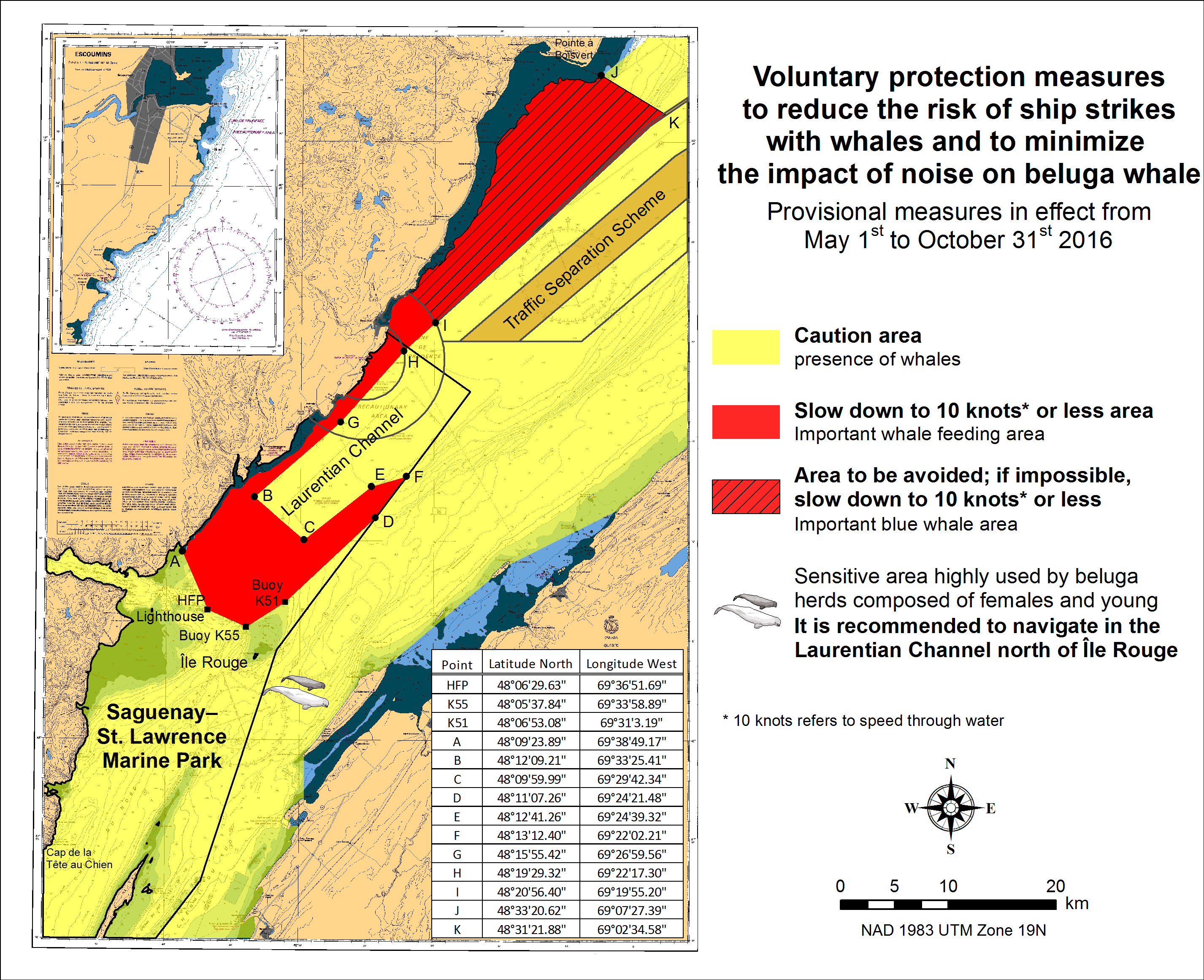
SAGUENAY-ST. LAWRENCE MARINE PARK AND SURROUNDING WATERS - WHALE PROTECTION.
The waters in and around the Saguenay-St. Lawrence Marine Park are well known for their resident threatened beluga population and the wide diversity of whales that migrate there to feed, particularly between April and November.
REGULATORY PROTECTION MEASURES
All whale species that are found in the St. Lawrence are protected under the Marine Mammal Regulations, pursuant to the Fisheries Act. Within the boundaries of the Marine Park, specific measures are set out in the Marine Activities in the Saguenay-St. Lawrence Marine Park Regulations, pursuant to the Act Establishing the Saguenay-St. Lawrence Marine Park. Any collision with a marine mammal within the Marine Park must immediately be reported to a park warden at 1-866-508-9888. For collisions that occur outside the Marine Park or for any situation involving a marine mammal that is dead or in trouble, contact the emergency network at 1-877-722-5346 or on channel 16.
For more information on the Saguenay-St. Lawrence Marine Park, see section 5C of the Annual Edition of the Notices to Mariners - April 2015 to March 2016.
VOLUNTARY PROTECTION MEASURES
Provisional measures in effect from May 1st to October 31st, 2016. See map below.
These measures apply to merchant vessels and cruise ships between Pointe à Boisvert and Cap de la Tête au Chien to prevent collisions with whales. These measures should only be taken when they will not jeopardize navigational safety.
Caution area (yellow area): To reduce the risk of collisions with whales that can be present anywhere in this area, heightened vigilance of navigators is critical. Posting a lookout is recommended in order to increase the chances of seeing the whales and thus taking necessary measures to avoid them. If bypassing the whales is not possible, slow down and wait for the animals to move away to a distance greater than 400 meters (0.215 nautical miles) before resuming original speed. It is more difficult to see the animals at night therefore increased caution is recommended.
Slow down to 10 knots or less area (red area): To reduce the risk of collisions with whales in this feeding area, it is recommended that vessels slow down to a maximum speed through the water of 10 knots and post a lookout. It is further recommended to remain in the Laurentian Channel to the north of Île Rouge to minimize the impact of noise in a sensitive area south of this island, which is highly frequented by herds of beluga whales composed of females and young.
Area to be avoided (hatched red area): To reduce noise and the risk of collisions with whales, vessels should avoid transiting through this area which is highly frequented by blue whales, an endangered species. If the area cannot be avoided, slow down to a speed through the water of 10 knots or less.
TRANSPORT CANADA - RESTRICTED SPEED AREA - ST. CLAIR AND DETROIT RIVER.
Since November 14, 2012 the restricted speed area currently in place as per the St. Clair and Detroit River Navigation Safety Regulation between the Detroit River light and Peche Island light is reduced in size by relocating the southern point of the restricted speed area from its current location at the Detroit River light to a new location at Bar Point light D33. (This notice refers to the previous one published in November 2012 with number *1103)
CANADIAN HYDROGRAPHIC SERVICE - ANNOUNCEMENT REGARDING TIDAL INFORMATION TABLES ON CHARTS.
CANADIAN COAST GUARD PUBLICATION - RADIO AIDS TO MARINE NAVIGATION (ATLANTIC, ST. LAWRENCE, GREAT LAKES, LAKE WINNIPEG AND EASTERN ARCTIC) PUBLICATION - 2013 - The Commercial Public Correspondence Service.
Part I - Page 1 of 10
ADVANCE NOTICES
The Commercial Public Correspondence Service
Effective January 1, 2014, the following changes to the Canadian Coast Guard commercial public correspondence service, provided through select Marine Communications and Traffic Services centres, will be in effect: All long distance ship-shore callswill be administered through the regular telephone service provider as a collect call . Individuals intending to place shore-ship calls will be required to direct-dial the appropriate MCTS centre. MCTS centres providing a commercial public correspondence service are identified in RAMN, Part 2.
*601 CANADIAN HYDROGRAPHIC SERVICE - NAUTICAL CHARTS
| CHARTS | MAIN TITLE | SCALE | PUBLISHED | CAT # | PRICE |
|---|---|---|---|---|---|
| New Editions | |||||
| 5048 | Cape Harrigan to/aux Kitlit Islands | 1:60000 | 25-DEC-2015 | 1 | 20.00 |
| 6419 | Norman Wells to/à Carcajou Ridge Kilometre 910 / Kilomètre 980 | 1:50000 | 15-JAN-2016 | 4 | 12.00 |
*602 CANADIAN HYDROGRAPHIC SERVICE - ELECTRONIC NAVIGATIONAL CHARTS
| NEW PRODUCTS | |
|---|---|
| S-57 ENC NUMBER | CHART TITLE |
| CA479191 | Rivière Péribonka |
| CA479193 | Rivière Ashuapmushuan |
| CA479199 | La Grande Décharge et les approches/and approaches |
| CA573478 | Putulik (Hat Island) |
| CA579192 | Péribonka |
| CA579194 | Saint-Félicien |
| CA579195 | Saint-Prime |
| CA579196 | Saint-Henri-de-Taillon |
| CA579197 | Entrée/Entrace La Grande Décharge |
| CA579200 | Dame-en-terre |
| CA579201 | Baie Gaudreault |
*603 TRANSPORT CANADA - SHIP SAFETY BULLETIN.
To go online to view or download this bulletin, please click on the link below:
Subject: Canadian Procedure for verification of the Gross Mass of Packed containers RDIMS#11733860
Issue: Bulletin No.: 04/2016
Date: 2016-05-12
Link: http://www.tc.gc.ca/eng/marinesafety/bulletins-2016-04-eng.htm
Sign yourself up for e-Bulletinto receive an e-mail notice each time a new Ship Safety Bulletin is published on our Web site.
Contact us at: marinesafety-securitemaritime@tc.gc.caor 1-855-859-3123 (Toll Free).
*604 CANADIAN HYDROGRAPHIC SERVICE - SAILING DIRECTIONS - ATL 109 IS NOW AVAILABLE AS A PRINT-ON-DEMAND (POD) PRODUCT.
Please note that despite the new look, the content remains the same except that the Notices to Mariners have been incorporated up to the date of printing.
*605 PLANS, BAIE DES CHALEURS/CHALEUR BAY (CÔTE NORD/NORTH SHORE)-PRIVATE LIGHT AID DELETED.
The following aid has been removed.
Port Daniel East light (LL 11614) (48° 10' 54.9''N 64° 57' 41.7''W)
Was replaced by (LL 1379.5) (48° 10' 54.8''N 64° 57' 42.0''W)
(Q2016-066, 065)
*606 WEDGEPORT AND VICINITY/ET LES ABORDS - TEMPORARY LIGHT ESTABLISHED.
A Temporary light has been installed at Whitehead Island (LL 295) (43°39'45".8N 65° 52' 02".5W) approx. flash characteristics have changed to Fl 4s Ec 11s and the nominal range has been reduced from 13 to 7.
The temporary light is temporarily replacing the previous light, however still serves as landfall.
(F2014-028)
*607 BASSIN DE CHAMBLY AU LAC/TO LAKE CHAMPLAIN - NEW CAUTIONARY LIGHT.
Two new cautionary private white lights established, Fl 4s, focal height 2m, installed on a pontoon:
Marina les Berges downstream, Ile aux Noix (LL12798) (45°08'27.54" N 73°15' 38.2860W)
Marina les Berges upstream, Ile aux Noix (LL12799) (45°08'25.7340" N 73°15' 38.4970W)
(Q2016-084, 085)
*608 PORT HOPE HARBOUR - INNER CHANNEL CLOSED.
The inner channel to Port Hope Yacht Club is closed. Entry is prohibited.
(NOTSHIP C499/16)
*609 LIST OF LIGHTS, BUOYS AND FOG SIGNALS - INLAND WATERS - NEW INFORMATION.
Mariners are cautioned that new aids added to certain older charts may not have a position available in the datum of the chart. The position will be identified in the available datum (ie. Position available is NAD83).
The following underlined information has been modified at page xx:
| WESTERN REGION | ||
| Victoria, BC. | Superintendent
Aids to Navigation and Waterways, 25 Huron Street, Victoria, BC, V8V 4V9, Tel.: 1 (250) 480-2600 (E), 1-800-667-2179 (T/F). |
Coastal waters from the North International Boundary to the South International Boundary of British Columbia; inland waters of British Columbia, Yukon, Alberta, Saskatchewan, and Manitoba, including the inland waters of Northwest Territories up to Tuktoyaktuk. |
| Email : | CGBaseVICMNS@pac.dfo-mpo.gc.ca | |
*610(T) GRAND BANK/GRAND BANC SOUTHERN PORTION/PARTIE SUD, ATLANTIC OCEAN/OCEAN ATLANTIQUE - HEBRON FIELD - PIPELINES INSTALLATION.
The Hebron Project has placed three, 2 km pipelines on the seabed in a triangular formation Pipelines are in place from May 12 2016 indefinitely.
The coordinates of the triangle are:
North 46° 33.732' N 048 30.232' W
South 46° 33.52' N 048 28.908' W
Southwest 46° 32.643' N 048 29.884' W
After May 14 2016 no vessels and no surface markers in the area until July 2016 a CPA of 1 nm is requested.
(NOTSHIP N552/16)
*611(P) CAPE GEORGE TO/À PICTOU- LIGHT TO BE DISCONTINUED
The Canadian Coast Guard proposes to permanently discontinue the following aid to navigation:
Pictou Island East end Breakwater light (LL 900.0) (45° 49' 20.7"N 062° 30' 34.2"W)
Comments on this action are solicited from mariners and other interested parties.
Comments should be directed to the following within three months from the date of this notice:
Superintendent, Aids to Navigation,
Canadian Coast Guard,
P.O. Box 5667,
St. John's, NL, A1C 5X1
Telephone: (709) 772-2800
Email: renee.pope@dfo-mpo.gc.ca
Any objections raised must state the facts on which they are based and should include supporting information on safety, commerce and public benefit.
(G2016-051)
SECTION 2 - CHART CORRECTIONS
| 1310 - Section A-B - New Edition - 10-JAN-2014 - NAD 1983 | |||
|
03-JUN-2016 |
|
LNM/D. 15-APR-2016 |
|
|
Amend |
vertical clearance of 9 metres 3 decimetres, to read 8 metres 9 decimetres
|
|
45°42′04.6″N 073°28′57.6″W |
|
This notice affects Electronic Navigational Chart: CA579001 |
|||
|
DFO(6409401-03) |
|||
| 1314 - Donnacona à/to Batiscan - New Edition - 21-JUN-2013 - NAD 1983 | |||
|
17-JUN-2016 |
|
LNM/D. 08-APR-2016 |
|
|
Affix |
patch |
|
46°28′20.0″N 071°47′20.0″W |
|
Download patch - http://www.chs-shc.gc.ca/patches/PA1314-20160511.pdf |
|||
|
DFO(6409450-01) |
|||
|
Amend |
vertical clearance of 4 metres 5 decimetres, to read 4 metres 1 decimetre
|
|
46°34′16.9″N 071°59′33.6″W |
|
This notice affects Electronic Navigational Chart: CA479017 |
|||
|
DFO(6409456-01) |
|||
|
Amend |
vertical clearance of 5 metres 8 decimetres, to read 4 metres 9 decimetres
|
|
46°34′29.2″N 072°12′35.1″W |
|
This notice affects Electronic Navigational Chart: CA479017 |
|||
|
DFO(6409456-02) |
|||
|
Amend |
vertical clearance of 3 metres 7 decimetres, to read 3 metres 3 decimetres
|
|
46°34′18.3″N 072°12′35.3″W |
|
This notice affects Electronic Navigational Chart: CA479017 |
|||
|
DFO(6409456-03) |
|||
|
Amend |
vertical clearance of 11 metres, to read 10 metres
|
|
46°33′27.9″N 072°02′44.3″W |
|
This notice affects Electronic Navigational Chart: CA479017 |
|||
|
DFO(6409456-04) |
|||
|
Amend |
vertical clearance of 5 metres 2 decimetres, to read 5 metres 6 decimetres
|
|
46°33′33.2″N 072°11′10.0″W |
|
This notice affects Electronic Navigational Chart: CA479017 |
|||
|
DFO(6409456-05) |
|||
|
Amend |
vertical clearance of 5 metres 8 decimetres, to read 5 metres 3 decimetres
|
|
46°34′28.5″N 071°59′35.7″W |
|
This notice affects Electronic Navigational Chart: CA479017 |
|||
|
DFO(6409456-06) |
|||
| 1509 - Pont-Viau à/to Île Bourdon E-F - Sheet/Feuille 2 - New Edition - 19-APR-2013 - NAD 1983 | |||
|
03-JUN-2016 |
|
LNM/D. 01-JAN-2016 |
|
|
Amend |
vertical clearance of 9 metres 3 decimetres, to read 8 metres 9 decimetres
|
|
45°42′04.4″N 073°28′57.7″W |
|
This notice affects Electronic Navigational Chart: CA579001 |
|||
|
DFO(6409401-01) |
|||
|
Amend |
vertical clearance of 9 metres 9 decimetres, to read 7 metres 2 decimetres
|
|
45°42′47.2″N 073°28′33.7″W |
|
This notice affects Electronic Navigational Chart: CA579180 |
|||
|
DFO(6409402-01) |
|||
| 1509 - Île Haynes - Sheet/Feuille 2 - New Edition - 19-APR-2013 - NAD 1983 | |||
|
03-JUN-2016 |
|
LNM/D. 01-JAN-2016 |
|
|
Amend |
vertical clearance of 9 metres 3 decimetres, to read 8 metres 9 decimetres
|
|
45°42′21.8″N 073°29′04.6″W |
|
This notice affects Electronic Navigational Chart: CA579180 |
|||
|
DFO(6409401-02) |
|||
| 2251 - Meldrum Bay to/à St.Joseph Island - Carte nouvelle - 11-APR-1986 - NAD 1927 | |||
|
24-JUN-2016 |
|
LNM/D. 03-DEC-2010 |
|
|
Add |
private light Fl Y, Priv
|
|
45°55′32.6″N 083°06′43.9″W |
|
This notice affects Electronic Navigational Chart: CA373060 |
|||
|
(D2015006) LL(1035.1) DFO(6604210-01) |
|||
|
Add |
breakwater, ″Bkw″
|
|
joining 45°55′36.3″N 083°06′45.4″W |
|
|
45°55′34.5″N 083°06′43.8″W |
||
|
|
and 45°55′32.6″N 083°06′43.9″W |
||
|
This notice affects Electronic Navigational Chart: CA373060 |
|||
|
DFO(6604210-02) |
|||
| 2299 - Clapperton Island to/à Meldrum Bay - New Edition - 25-MAY-2001 - NAD 1983 | |||
|
24-JUN-2016 |
|
LNM/D. 27-MAR-2015 |
|
|
Add |
private light Fl Y, Priv
|
|
45°55′32.6″N 083°06′43.9″W |
|
This notice affects Electronic Navigational Chart: CA373060 |
|||
|
(D2015006) LL(1035.1) DFO(6604210-01) |
|||
|
Add |
breakwater, ″Bkw″
|
|
between 45°55′36.3″N 083°06′45.4″W |
|
|
and 45°55′32.6″N 083°06′43.9″W |
||
|
This notice affects Electronic Navigational Chart: CA373060 |
|||
|
DFO(6604210-02) |
|||
| 4001 - Gulf of Maine to Strait of Belle Isle /au Detroit de Belle Isle - New Edition - 01-DEC-1995 - NAD 1983 | |||
|
24-JUN-2016 |
|
LNM/D. 13-MAY-2016 |
|
|
Delete |
private yellow ODAS/SADO lighted pillar buoy FlY, priv
|
|
47°58′43.2″N 046°48′28.8″W |
|
This notice affects Electronic Navigational Chart: CA176030 |
|||
|
DFO(6307548-01) |
|||
| 4002 - Golfe du Saint-Laurent / Gulf of St. Lawrence - New Edition - 30-OCT-2015 - NAD 1983 | |||
|
17-JUN-2016 |
|
LNM/D. 04-MAR-2016 |
|
|
Amend |
Fl 16M to read LFl 13M against light
|
|
45°54′24.0″N 059°57′30.0″W |
|
This notice affects Electronic Navigational Chart: CA179245, CA276204 |
|||
|
(G2016037 & G2016052) LL(756) DFO(6307520-01) |
|||
| 4003 - Cape Breton to/à Cape Cod - New Edition - 21-MAR-2003 - NAD 1983 | |||
|
17-JUN-2016 |
|
LNM/D. 13-MAY-2016 |
|
|
Amend |
Fl 16M to read LFl 13M against light
|
|
45°54′24.0″N 059°57′30.0″W |
|
This notice affects Electronic Navigational Chart: CA179245, CA276204 |
|||
|
(G2016037 & G2016052) LL(756) DFO(6307520-01) |
|||
| 4013 - Halifax to/à Sydney - New Edition - 06-SEPT-2002 - NAD 1983 | |||
|
17-JUN-2016 |
|
LNM/D. 06-MAY-2016 |
|
|
Amend |
Fl 10s 105ft 16M to read LFl 6s 105ft 13M against light
|
|
45°54′24.0″N 059°57′30.0″W |
|
This notice affects Electronic Navigational Chart: CA179245, CA276204 |
|||
|
(G2016037 & G2016052) LL(756) DFO(6307520-01) |
|||
| 4015 - Sydney to/à Saint-Pierre - New Edition - 28-MAR-2003 - NAD 1983 | |||
|
17-JUN-2016 |
|
LNM/D. 06-MAY-2016 |
|
|
Amend |
Fl 10s 105ft 16M to read LFl 6s 105ft 13M against light
|
|
45°54′24.0″N 059°57′30.0″W |
|
This notice affects Electronic Navigational Chart: CA179245, CA276204 |
|||
|
(G2016037 & G2016052) LL(756) DFO(6307520-01) |
|||
| 4023 - Northumberland Strait / Détroit de Northumberland - New Edition - 27-DEC-2002 - NAD 1983 | |||
|
17-JUN-2016 |
|
LNM/D. 10-JUN-2016 |
|
|
Amend |
FlG to read 2Lts FlR & FlG against light
|
|
47°01′45.7″N 063°59′19.8″W |
|
This notice affects Electronic Navigational Chart: CA276286 |
|||
|
(G2016033) LL(1036.1 & 1084.7) DFO(6307508-01) |
|||
|
10-JUN-2016 |
|
LNM/D. 27-MAY-2016 |
|
|
Add |
light FlG
|
|
46°34′56.7″N 064°43′10.2″W |
|
(G2016028) LL(1127.2) DFO(6307503-01) |
|||
| 4024 - Baie des Chaleurs/Chaleur Bay aux/to Îles de la Madeleine - New Edition - 06-MAR-2015 - NAD 1983 | |||
|
17-JUN-2016 |
|
LNM/D. 05-FEB-2016 |
|
|
Amend |
FlG 3s7m4M to read 2Lts FlR & FlG against light
|
|
47°01′45.7″N 063°59′19.8″W |
|
This notice affects Electronic Navigational Chart: CA276286 |
|||
|
(G2016033) LL(1036.1 & 1084.7) DFO(6307508-01) |
|||
| 4045 - Sable Island Bank/Banc de I'Île de Sable to/au St. Pierre Bank/Banc de Saint Pierre - New Edition - 10-OCT-2003 - NAD 1983 | |||
|
17-JUN-2016 |
|
LNM/D. 04-MAR-2016 |
|
|
Amend |
Fl 10s 32m 16M to read LFl 6s 32m 13M against light
|
|
45°54′24.0″N 059°57′30.0″W |
|
This notice affects Electronic Navigational Chart: CA179245, CA276204 |
|||
|
(G2016037 & G2016052) LL(756) DFO(6307520-01) |
|||
| 4114 - Campobello Island - New Edition - 24-APR-2015 - NAD 1983 | |||
|
03-JUN-2016 |
|
LNM/D. 05-FEB-2016 |
|
|
Reposition |
green port hand can buoy, marked 5
|
|
de 44°51′03.3″N 066°58′27.7″W |
|
|
à 44°51′04.8″N 066°58′28.8″W |
||
|
(NOS:LNM: 17/16) DFO(6307534-01) |
|||
| 4170 - Glace Bay Harbour - New Chart - 28-FEB-1992 - NAD 1983 | |||
|
10-JUN-2016 |
|
LNM/D. 29-APR-2016 |
|
|
Add |
light QG
|
|
46°11′55.1″N 059°56′49.4″W |
|
This notice affects Electronic Navigational Chart: CA376093 |
|||
|
(G2016027) LL(773.5) DFO(6307502-01) |
|||
| 4201 - Halifax Harbour - Bedford Basin - New Edition - 11-AUG-2000 - NAD 1983 | |||
|
17-JUN-2016 |
|
LNM/D. 11-MAR-2016 |
|
|
Affix |
Patch |
|
44°40′20.0″N 063°37′00.0″W |
|
Download patch - http://www.chs-shc.gc.ca/patches/4201PA_20160512.pdf |
|||
|
DFO(6307547-01) |
|||
|
Add |
depth of 13 metres, 9 decimetres
|
|
44°40′39.7″N 063°36′33.8″W |
|
DFO(6307547-02) |
|||
|
Remplacer |
floating dry dock with works under construction (2015)
|
|
joining 44°40′04.1″N 063°35′38.6″W
|
|
DFO(6307547-03) |
|||
|
Delete |
light FG
|
|
44°40′11.1″N 063°35′44.4″W |
|
DFO(6307547-11) |
|||
|
Delete |
light FG
|
|
44°40′05.5″N 063°35′37.3″W |
|
DFO(6307547-12) |
|||
| 4203 - Halifax Harbour - Black Point to/à Point Pleasant - New Edition - 14-APR-2000 - NAD 1983 | |||
|
17-JUN-2016 |
|
LNM/D. 04-DEC-2015 |
|
|
Add |
wreck WK with known depth of 11 metres, 8 decimetres.
|
|
44°37′19.3″N 063°31′20.3″W |
|
DFO(6307547-04) |
|||
|
Reposition |
private orange and white mooring barrel buoy, marked Priv
|
|
de 44°37′17.5″N 063°30′44.1″W |
|
|
à 44°37′17.2″N 063°30′46.6″W |
||
|
DFO(6307547-05) |
|||
|
Add |
private orange and white mooring barrel buoy, Priv
|
|
44°37′19.0″N 063°30′44.0″W |
|
DFO(6307547-06) |
|||
|
Delete |
light 2F R(Vert)
|
|
44°37′10.0″N 063°30′36.5″W |
|
DFO(6307547-07) |
|||
|
Amend |
2 FR (Vert) to read 2 LtS FR (vert)(Priv) against light
|
|
44°37′09.4″N 063°30′35.7″W |
|
DFO(6307547-08) |
|||
|
Delete |
submarine cable
|
|
between 44°37′14.7″N 063°30′42.8″W |
|
|
and 44°37′17.5″N 063°30′44.1″W |
||
|
DFO(6307547-09) |
|||
|
Add |
submarine cable
|
|
between 44°37′14.7″N 063°30′42.8″W |
|
|
and 44°37′17.2″N 063°30′46.6″W |
||
|
DFO(6307547-10) |
|||
| 4233 - Cape Canso to/à Country Island - Carte nouvelle - 11-JAN-1991 - NAD 1983 | |||
|
17-JUN-2016 |
|
LNM/D. 11-MAR-2016 |
|
|
Amend |
Fog Sig 20s to read Fog Sig 20s (Occas) against beacon
|
|
45°16′17.2″N 061°01′27.0″W |
|
This notice affects Electronic Navigational Chart: CA376067 |
|||
|
(G2016050) DFO(6307542-01) |
|||
| 4367 - Flint Island to/à Cape Smokey - New Edition - 03-APR-2003 - NAD 1983 | |||
|
10-JUN-2016 |
|
LNM/D. 29-APR-2016 |
|
|
Add |
light QG
|
|
46°11′56.2″N 059°56′51.0″W |
|
This notice affects Electronic Navigational Chart: CA376093 |
|||
|
(G2016027) LL(773.5) DFO(6307502-01) |
|||
| 4375 - Guyon Island to/à Flint Island - Nouvelle édition - 11-OCT-2002 - NAD 1983 | |||
|
17-JUN-2016 |
|
LNM/D. 04-MAR-2016 |
|
|
Replace |
light Fl 10s 105ft 16M with all-round light LFl 6s 105ft 13M with obscured sector. Obscured through an arc of 210°, from 250° to 100°
|
|
45°54′24.0″N 059°57′30.4″W |
|
This notice affects Electronic Navigational Chart: CA376303 |
|||
|
(G2016037 & G2016052) LL(756) DFO(6307520-02) |
|||
| 4376 - Louisbourg Harbour - New Edition - 14-JUN-2002 - NAD 1983 | |||
|
17-JUN-2016 |
|
LNM/D. 13-MAY-2016 |
|
|
Replace |
light Fl 10s 105ft 16M with all-round light LFl 6s 105ft 13M with obscured sector. Obscured through an arc of 210°, from 250° to 100°
|
|
45°54′24.0″N 059°57′30.4″W |
|
This notice affects Electronic Navigational Chart: CA376303 |
|||
|
(G2016037 & G2016052) LL(756) DFO(6307520-02) |
|||
| 4384 - Pearl Island to/à Cape La Have - New Edition - 10-JAN-2003 - NAD 1983 | |||
|
17-JUN-2016 |
|
LNM/D. 06-MAY-2016 |
|
|
Amend |
Fl to read Q(6)+LFl 15s against light
|
|
44°16′01.2″N 064°21′50.2″W |
|
This notice affects Electronic Navigational Chart: CA476664 |
|||
|
(F2016017) LL(428) DFO(6307540-01) |
|||
| 4394 - LaHave River - West Ironbound Island to/à Riverport - New Edition - 26-JUL-2002 - NAD 1983 | |||
|
17-JUN-2016 |
|
LNM/D. 06-MAY-2016 |
|
|
Amend |
Fl to read Q(6)+LFl 15s against light
|
|
44°16′01.3″N 064°21′50.5″W |
|
This notice affects Electronic Navigational Chart: CA476664 |
|||
|
(F2016017) LL(428) DFO(6307540-01) |
|||
| 4437 - Pictou Harbour - New Edition - 14-MAR-2003 - NAD 1983 | |||
|
10-JUN-2016 |
|
LNM/D. 13-NOV-2015 |
|
|
Add |
wharf
|
|
joining 45°40′30.3″N 062°41′01.6″W |
|
|
45°40′30.4″N 062°40′57.5″W |
||
|
|
45°40′33.7″N 062°40′57.5″W |
||
|
|
and 45°40′33.6″N 062°41′00.0″W |
||
|
DFO(6307504-01) |
|||
|
Add |
light FlG
|
|
45°40′33.6″N 062°40′59.7″W |
|
(G2016029) LL(905.4) DFO(6307504-02) |
|||
|
Delete |
depth of 2 feet
|
|
45°40′31.3″N 062°40′57.6″W |
|
DFO(6307504-03) |
|||
|
Add |
light FlR
|
|
45°40′33.5″N 062°41′00.7″W |
|
(G2016030) LL(905.5) DFO(6307504-04) |
|||
| 4468 - Havre de Harrington - New Edition - 27-FEB-2015 - NAD 1983 | |||
|
03-JUN-2016 |
|
LNM/D. 21-AUG-2015 |
|
|
Add |
underwater rock of unknown depth, dangerous to surface navigation
|
|
50°30′23.0″N 059°28′46.6″W |
|
This notice affects Electronic Navigational Chart: CA479116 |
|||
|
DFO(6409315-01) |
|||
| 4497 - Amet Sound - New Edition - 27-JUN-2003 - NAD 1983 | |||
|
10-JUN-2016 |
|
LNM/D. 24-JUL-2015 |
|
|
Add |
light FlG
|
|
45°47′50.3″N 063°07′25.4″W |
|
(G2016031) LL(921.2) DFO(6307506-01) |
|||
|
Add |
breakwater extension
|
|
between 45°47′49.8″N 063°07′29.1″W |
|
|
and 45°47′50.3″N 063°07′25.4″W |
||
|
DFO(6307506-02) |
|||
|
Add |
light FlR
|
|
45°47′51.0″N 063°07′23.4″W |
|
(G2016032) LL(921.21) DFO(6307506-03) |
|||
|
Delete |
pier
|
|
joining 45°47′53.9″N 063°07′29.2″W |
|
|
45°47′50.3″N 063°07′27.4″W |
||
|
|
and 45°47′50.1″N 063°07′25.7″W |
||
|
DFO(6307506-04) |
|||
|
Add |
breakwater
|
|
joining 45°47′51.0″N 063°07′23.4″W |
|
|
45°47′51.4″N 063°07′23.0″W |
||
|
|
45°47′54.6″N 063°07′24.9″W |
||
|
|
and 45°47′55.0″N 063°07′28.0″W |
||
|
DFO(6307506-05) |
|||
| 4512 - Quirpon Harbour and Approaches/et les approches - New Edition - 24-JAN-2003 - NAD 1983 | |||
|
24-JUN-2016 |
|
LNM/D. 19-FEB-2016 |
|
|
Add |
extension to pier
|
|
joining 51°35′17.5″N 055°29′32.3″W |
|
|
51°35′18.1″N 055°29′32.8″W |
||
|
|
and 51°35′18.6″N 055°29′34.5″W |
||
|
DFO(6307549-01) |
|||
| 4617 - Red Island to/à Pinchgut Point - New Edition - 30-APR-2010 - NAD 1983 | |||
|
03-JUN-2016 |
|
LNM/D. 25-MAR-2016 |
|
|
Delete |
limit of routeing measure
|
|
between 47°22′50.0″N 054°04′46.8″W |
|
|
et 47°21′28.3″N 054°05′00.5″W |
||
|
This notice affects Electronic Navigational Chart: CA376173, CA376296, CA476300 |
|||
|
DFO(6307536-01) |
|||
|
Add |
limit of routeing measure
|
|
between 47°21′28.3″N 054°01′44.3″W |
|
|
and 47°24′45.7″N 053°52′35.5″W |
||
|
This notice affects Electronic Navigational Chart: CA376173, CA376296, CA476300, CA576298 |
|||
|
DFO(6307536-03) |
|||
|
Add |
limit of routeing measure
|
|
between 47°21′28.3″N 054°02′39.9″W |
|
|
and 47°25′01.3″N 053°52′47.6″W |
||
|
This notice affects Electronic Navigational Chart: CA376173, CA376296, CA476300 |
|||
|
DFO(6307536-04) |
|||
|
Add |
limit of routeing measure
|
|
between 47°22′50.0″N 054°04′46.8″W |
|
|
and 47°21′28.3″N 054°02′59.2″W |
||
|
This notice affects Electronic Navigational Chart: CA476300 |
|||
|
DFO(6307536-05) |
|||
| 4622 - Cape St. Mary's to/à Argentia Harbour and/et Jude Island - New Edition - 03-OCT-2003 - NAD 1983 | |||
|
03-JUN-2016 |
|
LNM/D. 12-FEB-2016 |
|
|
Delete |
limit of routeing measure
|
|
between 47°22′50.0″N 054°04′46.8″W |
|
|
and 47°18′41.0″N 054°05′40.2″W |
||
|
This notice affects Electronic Navigational Chart: CA376173, CA376296, CA476300 |
|||
|
DFO(6307536-01) |
|||
|
Add |
limit of routeing measure
|
|
joining 47°19′49.0″N 053°57′58.3″W |
|
|
47°20′37.7″N 053°59′59.3″W |
||
|
|
and 47°18′41.0″N 054°05′40.2″W |
||
|
This notice affects Electronic Navigational Chart: CA376173, CA376296, CA576298 |
|||
|
DFO(6307536-02) |
|||
|
Add |
limit of routeing measure
|
|
joining 47°24′45.7″N 053°52′35.5″W |
|
|
47°21′10.1″N 054°02′35.0″W |
||
|
|
47°20′32.9″N 054°01′46.5″W |
||
|
|
47°21′10.0″N 053°59′59.4″W |
||
|
|
and 47°20′12.1″N 053°57′37.5″W |
||
|
This notice affects Electronic Navigational Chart: CA376173, CA376296, CA476300, CA576298 |
|||
|
DFO(6307536-03) |
|||
|
Add |
limit of routeing measure
|
|
joining 47°22′50.0″N 054°04′46.8″W |
|
|
47°21′23.6″N 054°02′53.0″W |
||
|
|
and 47°25′00.0″N 053°52′51.3″W |
||
|
This notice affects Electronic Navigational Chart: CA376173, CA376296, CA476300 |
|||
|
DFO(6307536-04) |
|||
|
Add |
ferry route
|
|
joining 47°17′27.5″N 053°59′10.5″W |
|
|
47°18′22.0″N 053°57′41.2″W |
||
|
|
47°19′46.7″N 053°57′41.2″W |
||
|
|
and 47°19′52.4″N 053°57′55.2″W |
||
|
This notice affects Electronic Navigational Chart: CA376173, CA376296, CA576298 |
|||
|
DFO(6307536-06) |
|||
| 4824 - La Poile - New Chart - 25-OCT-2002 - NAD 1983 | |||
|
03-JUN-2016 |
|
LNM/D. 01-APR-2016 |
|
|
Reposition |
red starboard hand lighted spar buoy FlR, marked QE4
|
|
from 47°41′01.4″N 058°23′22.0″W |
|
|
to 47°41′01.4″N 058°23′23.0″W |
||
|
LL(145.83) DFO(6307535-01) |
|||
| 4841 - Argentia - New Edition - 29-MAY-2015 - NAD 1983 | |||
|
03-JUN-2016 |
|
||
|
Add |
limit of routeing measure
|
|
joining 47°19′49.0″N 053°57′58.3″W |
|
|
47°20′37.7″N 053°59′59.3″W |
||
|
|
and 47°20′18.0″N 054°00′56.7″W |
||
|
This notice affects Electronic Navigational Chart: CA376173, CA376296, CA576298 |
|||
|
DFO(6307536-02) |
|||
|
Add |
limit of routeing measure
|
|
joining 47°20′50.1″N 054°00′56.7″W |
|
|
47°21′10.0″N 053°59′59.4″W |
||
|
|
and 47°20′12.1″N 053°57′37.5″W |
||
|
This notice affects Electronic Navigational Chart: CA376173, CA376296, CA476300, CA576298 |
|||
|
DFO(6307536-03) |
|||
|
Add |
ferry route
|
|
joining 47°17′27.5″N 053°59′10.5″W |
|
|
47°18′22.0″N 053°57′41.2″W |
||
|
|
47°19′46.7″N 053°57′41.2″W |
||
|
|
and 47°19′52.4″N 053°57′55.2″W |
||
|
This notice affects Electronic Navigational Chart: CA376173, CA376296, CA576298 |
|||
|
DFO(6307536-06) |
|||
| 4841 - Cape St Mary's to/à Argentia - New Edition - 29-MAY-2015 - NAD 1983 | |||
|
03-JUN-2016 |
|
||
|
Delete |
limit of routeing measure
|
|
between 47°22′29.7″N 054°04′49.3″W |
|
|
and 47°18′43.3″N 054°05′33.8″W |
||
|
This notice affects Electronic Navigational Chart: CA376173, CA376296, CA476300 |
|||
|
DFO(6307536-01) |
|||
|
Add |
limit of routeing measure
|
|
joining 47°19′49.0″N 053°57′58.3″W |
|
|
47°20′37.7″N 053°59′59.3″W |
||
|
|
and 47°18′43.2″N 054°05′33.7″W |
||
|
This notice affects Electronic Navigational Chart: CA376173, CA376296, CA576298 |
|||
|
DFO(6307536-02) |
|||
|
Add |
limit of routeing measure
|
|
joining 47°22′29.7″N 053°58′53.6″W |
|
|
47°21′10.1″N 054°02′35.0″W |
||
|
|
47°20′32.9″N 054°01′46.5″W |
||
|
|
47°21′10.0″N 053°59′59.4″W |
||
|
|
and 47°20′12.1″N 053°57′37.5″W |
||
|
This notice affects Electronic Navigational Chart: CA376173, CA376296, CA476300, CA576298 |
|||
|
DFO(6307536-03) |
|||
|
Add |
limit of routeing measure
|
|
joining 47°22′29.7″N 054°04′20.1″W |
|
|
47°21′23.6″N 054°02′53.0″W |
||
|
|
and 47°22′29.7″N 053°59′49.1″W |
||
|
This notice affects Electronic Navigational Chart: CA376173, CA376296, CA476300 |
|||
|
DFO(6307536-04) |
|||
|
Add |
ferry route
|
|
joining 47°17′27.5″N 053°59′10.5″W |
|
|
47°18′22.0″N 053°57′41.2″W |
||
|
|
47°19′46.7″N 053°57′41.2″W |
||
|
|
and 47°19′52.4″N 053°57′55.2″W |
||
|
This notice affects Electronic Navigational Chart: CA376173, CA376296, CA576298 |
|||
|
DFO(6307536-06) |
|||
| 4863 - Bacalhao Island to/à Black Island - New Edition - 30-NOV-2001 - NAD 1983 | |||
|
17-JUN-2016 |
|
LNM/D. 26-FEB-2016 |
|
|
Amend |
FlG to read FlY against light
|
|
49°24′19.7″N 054°51′17.2″W |
|
This notice affects Electronic Navigational Chart: CA476802 |
|||
|
(N2016003) LL(353.9) DFO(6307541-01) |
|||
| 4864 - Black Island to/à Little Denier Island - New Chart - 25-AUG-2006 - NAD 1983 | |||
|
24-JUN-2016 |
|
LNM/D. 27-DEC-2013 |
|
|
Add |
marine farm
|
|
49°20′54.0″N 055°20′09.0″W |
|
This notice affects Electronic Navigational Chart: CA476639 |
|||
|
DFO(6307550-01) |
|||
| 4905 - Cape Tormentine à/to West Point - New Edition - 29-DEC-2000 - NAD 1983 | |||
|
10-JUN-2016 |
|
LNM/D. 27-NOV-2015 |
|
|
Add |
light FlG
|
|
46°34′56.7″N 064°43′10.2″W |
|
This notice affects Electronic Navigational Chart: CA276286, CA376076 |
|||
|
(G2016028) LL(1127.2) DFO(6307503-01) |
|||
|
4906 - West Point à/to Baie de Tracadie - New Chart - 18-MAR-1988 - NAD 1983 |
|||
|
17-JUN-2016 |
|
LNM/D. 29-APR-2016 |
|
|
Reposition |
green port hand lighted pillar buoy QG, marked Q3
|
|
from 46°43′00.6″N 064°44′34.1″W |
|
|
to 46°42′54.1″N 064°44′46.6″W |
||
|
This notice affects Electronic Navigational Chart: CA476131 |
|||
|
(G2016048) LL(1132) DFO(6307537-01) |
|||
| 4909 - Buctouche Harbour - New Chart - 17-JUN-1988 - NAD 1983 | |||
|
24-JUN-2016 |
|
LNM/D. 17-JUN-2016 |
|
|
Reposition |
red starboard hand lighted pillar buoy FlR, marked XV6
|
|
from 46°27′12.7″N 064°37′20.7″W |
|
|
to 46°27′06.8″N 064°37′12.1″W |
||
|
This notice affects Electronic Navigational Chart: CA476127 |
|||
|
(G2016053) LL(1119.65) DFO(6307545-01) |
|||
| 4909 - Richibucto Harbour - New Chart - 17-JUN-1988 - NAD 1983 | |||
|
17-JUN-2016 |
|
LNM/D. 27-NOV-2015 |
|
|
Reposition |
green port hand lighted pillar buoy QG, marked Q3
|
|
from 46°43′00.6″N 064°44′34.1″W |
|
|
to 46°42′54.1″N 064°44′46.6″W |
||
|
This notice affects Electronic Navigational Chart: CA476131 |
|||
|
(G2016048) LL(1132) DFO(6307537-01) |
|||
|
Delete |
green port hand lighted pillar buoy FlG, marked Q5
|
|
46°42′51.0″N 064°44′42.6″W |
|
This notice affects Electronic Navigational Chart: CA476131 |
|||
|
(G2016049) LL(1133.1) DFO(6307537-02) |
|||
|
Add |
green port hand lighted can buoy FlG, marked Q5
|
|
46°42′33.6″N 064°45′01.1″W |
|
This notice affects Electronic Navigational Chart: CA476131 |
|||
|
(G2016049) LL(1133.1) DFO(6307537-03) |
|||
| 4956 - Cap-aux-Meules - New Edition - 02-SEPT-2011 - NAD 1983 | |||
|
17-JUN-2016 |
|
LNM/D. 08-JAN-2016 |
|
|
Delete |
depth of 4 metres 4 decimetres
|
|
47°22′47.4″N 061°51′17.3″W |
|
This notice affects Electronic Navigational Chart: CA579046 |
|||
|
DFO(6409412-01) |
|||
|
Add |
depth of 3 metres 7 decimetres
|
|
47°22′47.5″N 061°51′17.4″W |
|
This notice affects Electronic Navigational Chart: CA579046 |
|||
|
DFO(6409412-02) |
|||
|
Delete |
depth of 4 metres 3 decimetres
|
|
47°22′45.7″N 061°51′22.0″W |
|
This notice affects Electronic Navigational Chart: CA579046 |
|||
|
DFO(6409412-03) |
|||
|
Delete |
depth of 3 metres 8 decimetres
|
|
47°22′46.4″N 061°51′22.4″W |
|
This notice affects Electronic Navigational Chart: CA579046 |
|||
|
DFO(6409412-04) |
|||
|
Add |
depth of 3 metres 4 decimetres
|
|
47°22′46.3″N 061°51′22.8″W |
|
This notice affects Electronic Navigational Chart: CA579046 |
|||
|
DFO(6409412-05) |
|||
|
Delete |
depth of 4 metres 5 decimetres
|
|
47°22′48.1″N 061°51′21.6″W |
|
This notice affects Electronic Navigational Chart: CA579046 |
|||
|
DFO(6409412-06) |
|||
|
Add |
depth of 3 metres 9 decimetres
|
|
47°22′48.1″N 061°51′21.2″W |
|
This notice affects Electronic Navigational Chart: CA579046 |
|||
|
DFO(6409412-07) |
|||
| 5440 - Wager Bay - New Edition - 26-NOV-2004 - Unknown | |||
|
17-JUN-2016 |
|
||
|
Add |
obstruction, depth unknown ″Rep (2016)″
|
|
65°20′38.8″N 088°11′56.2″W |
|
DFO(6604216-01) |
|||
|
Add |
obstruction, depth unknown ″Rep (2016)″
|
|
65°21′13.7″N 088°14′15.4″W |
|
DFO(6604216-02) |
|||
|
Add |
obstruction, depth unknown ″Rep (2016)″
|
|
65°31′26.3″N 088°39′24.2″W |
|
DFO(6604216-03) |
|||
|
Add |
obstruction, depth unknown ″Rep (2016)″
|
|
65°35′23.4″N 088°47′55.9″W |
|
DFO(6604216-04) |
|||
|
Add |
obstruction, depth unknown ″Rep (2016)″
|
|
65°39′26.9″N 088°56′15.4″W |
|
DFO(6604216-05) |
|||
| 8012 - Flemish Pass/Passe Flamande - Nouvelle édition - 11-OCT-2002 - NAD 1983 | |||
|
24-JUN-2016 |
|
LNM/D. 13-MAY-2016 |
|
|
Delete |
private yellow ODAS/SADO lighted pillar buoy FlY, priv
|
|
47°58′43.2″N 046°48′28.8″W |
|
This notice affects Electronic Navigational Chart: CA176030 |
|||
|
DFO(6307548-01) |
|||
SECTION 3 - RADIO AIDS TO MARINE NAVIGATION CORRECTIONS
SECTION 4 - SAILING DIRECTIONS AND SMALL CRAFT GUIDE CORRECTIONS
ATL 101 — Newfoundland — Northeast and East Coasts, Second Edition, 2013 —
Chapter 4 — Paragraph 223
Delete: 535-3625
Replace by: 535-3633, (Fax) 709-535-3632 and e-mail at lmaa@eastlink.ca
(N2016-04.3)
ATL 104 — Cape North to Cape Canso (including Bras d’Or Lake), Second Edition, 2010 —
Chapter 1 — Paragraph 110, after “high, on Lighthouse Point.”
Insert: The light is visible from 250° through W, N and E to 100°.
(A2016-004.6)
ATL 105 — Cape Canso to Cape Sable (including Sable Island), Second Edition, 2014 —
Chapter 4 — Paragraph 91, after “skeleton tower”
Insert: having port hand daymarks
Chapter 5 — Paragraph 95, after “A light (367)”
Insert: having a starboard hand daymark
(A2016-005.2)
ATL 106 — Gulf of Maine and Bay of Fundy, First Edition, 2001 —
Chapter 3 — After paragraph 1
Insert: 1.1 Aquaculture. — The waters around Grand Manan Island, as well as its coves and shorelines, sustain many fishing weirs and aquaculture operations. Mariners are cautioned that these can present surface dangers and underwater hazards, which can damage vessels or result in fouling.
(A2016-006.6)
Chapter 3 — Adjacent to paragraph 1.1, add a caution pictograph.
(A2016-006.7)
Chapter 3 — Paragraph 120, last line
Add: A radar reflector is shown in the east channel of the approach to Richardson, on a rocky ledge
0.2 mile south of Bag Ledge.
(A2016-006.8)
CEN 302 — Lake Ontario, First Edition, 1996 —
(C2016-012.01)
Chapter 3 — Paragraph 70
Delete: and a yacht club
(C2016-012.02)
Chapter 3 — Delete paragraph 72.
(C2016-012.03)
SECTION 5 - LIST OF LIGHTS, BUOYS AND FOG SIGNALS CORRECTIONS
Newfoundland
| No. | Name | Position ----- Latitude N. Longitude W. |
Light Characteristics |
Focal Height in m. above water |
Nominal Range |
Description ----- Height in meters above ground |
Remarks ----- Fog Signals |
|||
|---|---|---|---|---|---|---|---|---|---|---|
| 352.97 | Shoal Tickle - Light buoy DSP2 |
Little Burnt Bay. 49 21 14.2 055 01 44.8 |
Q | R | 1s | ….. | ….. | Red spar, marked "DSP2". |
Privately owned. Seasonal. Chart:4865 Edn 06/16 (N13-024) |
|
| 353.9 | Comfort Cove, wharf | 49 24 19.7 54 51 17.2 |
Fl | Y | 4s | ..... | 2 | Cylindrical mast. | Seasonal. Chart:4863 Edn 06/16 (N16-003) |
|
Atlantic
| No. | Name | Position ----- Latitude N. Longitude W. |
Light Characteristics |
Focal Height in m. above water |
Nominal Range |
Description ----- Height in meters above ground |
Remarks ----- Fog Signals |
||||
|---|---|---|---|---|---|---|---|---|---|---|---|
| 56 H4140 |
Stuart Town, breakwater |
45 01 11.8 066 56 06.5 |
Fl | W | 4s | 5.6 | 6 | Triangular skeleton tower. 6.1 |
Flash 1s., Eclipse 3s. Operates at night only. Year round.. Chart:4124 Edn 06/16 (F16-015) |
||
| 428 H3711 |
Dublin Shore light cardinal sud. | On the wharf. 44 16 01.2 064 21 50.2 |
Q(6)+LFl | W | 15s | 8.4 | 5 | Cylindrical mast, black with yellow band at top. 3.4 |
6 (Flash 0.3s, Eclipse 0.7s) Radar reflector. Operates at night only. Year round. Chart:4394 Edn 06/16 (F16-017) |
||
| 756 H3344 |
Louisbourg | On lighthouse point, N. side of entrance of harbour. 45 54 24.0 059 57 30.5 |
LFl | W | 6s | 31.9 | 13 | White octogonal tower, red upper portion. 15.4 |
Flash 2 s, Eclipse 4 s. Visible from 100° to 250°. Operates at night only. Year round. Horns(2) - Blast 2 s; sil.18 s. Horns point 138°. Chart:4376 Edn 06/16 (G16-052) |
||
| 773.5 | Glace Bay, Breakwater South |
Near outer end of South breakwater. 46 11 55.1 059 56 49.4 |
Q | G | 1s | ….. | 3 | Pipe swing pole, green, white, and black, square daymark. 3 |
Year round. In operation 24h. Chart:4170 Edn 06/16 (G16-027) |
||
| 905.4 | Pictou Landing East – Light buoy | 45 40 33.6 062 40 59.7 |
Fl | G | 4s | ….. | ….. | Privately maintained. Seasonal. Operate at night onlyh. Position is approximate. Owned by Small Craft Harbours. Chart:4405 Edn 06/16 (G16-029) |
|||
| 905.5 | Pictou Landing West – Light buoy | 45 40 33.5 062 41 00.7 |
Fl | R | 4s | ….. | ….. | Privately maintained. Seasonal. Operate at night onlyh. Position is approximate. Owned by Small Craft Harbours. Chart:4437 Edn 06/16 (G16-030) |
|||
| 921.2 | Cape John West | 45 47 50.3 063 07 25.4 |
Fl | G | 4s | ….. | 2 | Green, white and black square daymark. | Privately maintained. Seasonal. Operates at night only. Chart:4404 Edn 06/16 (G16-031) |
||
| 921.21 | Cape John East | 45 47 51.0 063 07 23.4 |
Fl | R | 4s | ….. | 2 | Red triangular daymark. | Privately maintained. Seasonal. Operates at night only. Chart:4404 Edn 06/16 (G16-032) |
||
| 1036.1 | Seacow Pond North | 47 01 45.7 063 59 19.8 |
Fl | R | 4s | ….. | ….. | Privately maintained. Seasonal. Operates at night only. Position is approximate. Owned by the Small Craft Harbours. Chart:4906 Edn 06/16 (G16-033) |
|||
| 1082.1 H1095 |
Alberton, breakwater |
Outer end of Breakwater. 46 47 38.9 064 03 35.2 |
Fl |
W |
3s |
6 |
2 |
Cylindrical mast. 2.6 |
Privately maintained. Operates at night only. Seasonal. Chart:4492 Edn 06/16 (G16-034) |
||
| 1119.65 | Buctouche Harbour - Light buoy XV6 | 46 27 06.8 064 37 12.1 |
Fl | R | 4s | ..... | ..... | Red, marked "XV6". | Seasonal. Buoy may be repositioned due to shifting channel. Chart:4909 Edn 06/16 (G16-053) |
||
| 1127.2 | Chockpish, breakwater South |
On outermost end of south breakwater. 46 34 58.1 064 43 10.5 |
Fl | G | 4s | ….. | 3 | Pipe swing pole, green, white, and black square daymark. 3 |
Privately maintained.. Seasonal. Operates at night only. Chart:4905 Edn 06/16 (G16-028) |
||
| 1132 | Entrance Richibucto Gully - Light buoy Q3 | 46 42 54.1 064 44 46.6 |
Q | G | 1s | ..... | ..... | Green, marked "Q3". | Buoy may be repositioned due to shifting channel. Seasonal. Chart: 4909 Edn 06/16 (G16-048) |
||
| 1133.1 | Richibucto - Light buoy Q5 | 46 42 33.7 064 45 01.1 |
Fl | G | 4s | ..... | ..... | Green, marked "Q5". | Buoy may be repositioned due to shifting channel. Seasonal. Chart:4909 Edn 06/16 (G16-049) |
||
| 1379.5 | Port Daniel East FR |
At the extremity of the breakwater. 48 10 54.8 064 57 42.0 |
Iso | R | 2s | ….. | 3 | Cylindrical mast. | Seasonal. Operates at night only. Chart:4921 Edn 06/16 (Q16-066) |
||
Inland Waters
| No. | Name | Position ----- Latitude N. Longitude W. |
Light Characteristics |
Focal Height in m. above water |
Nominal Range |
Description ----- Height in meters above ground |
Remarks ----- Fog Signals |
|||
|---|---|---|---|---|---|---|---|---|---|---|
| 1035.1 | Meldrum Bay, breakwater | Eastern point of rubble breakwater. 45 55 32.6 083 06 43.9 |
Fl | Y | 4s | 3.9 | ….. | Cylindrical mast. 0.9 |
Privately maintained. Seasonal. Chart:2251 Edn 06/16 (D15-006) |
|
| 1059.6 1059.7 |
Hay Point - range |
On the point, St. Joseph Island. 46 07 36.7 083 59 58.8 128°37’ 329.5m from front. |
F F |
W W |
..... ..... |
13.9 22.5 |
12 ..... |
White cylindrical tower, white daymark, orange vertical stripe. 12.2 Skeleton tower, white daymark, orange vertical stripe. 20.9 |
Year round. Year round. Chart:14882 (É.-U.) Edn 06/16 (D16-005) |
|
| 1643.1 | Cormorant Island - Light buoy JA10 |
Near SW. tip of Cormorant Island. 52 51 04 099 57 36 |
Fl | R | 4s | ….. | ….. | Red spar, marked "JA10". | Position in NAD83. Seasonal. Chart: 6273 Edn 06/16 (A16-006) |
|
CANADIAN COAST GUARD - MARINE INFORMATION REPORT AND SUGGESTION SHEET
Name of Ship or Sender:..................................................................... Date:....................................
Address of Sender:..........................................................................................................................
Street # Street Name
Town / City:.............................. Prov / State:....................... Postal Code / Zip Code: ........................
Tel / Fax / E-mail address of sender (if appropriate):............................................................................
Observation Date:............................................. Time (UTC): ...........................................................
Geographical Position:......................................................................................................................
Coordinate Position: Lat: ............................................... Long:.........................................................
Position Method: DGPS GPS with WAAS GPS Radar Other
Horizontal Datum Used: WGS 84 NAD 27 Other
Estimated Position Accuracy:............................................................................................................
Chart #:............................................................ Datum: NAD 27 NAD 83
Chart Edition:.................................................... Last Correction applied:............................................
Publications affected: (Quote edition and page number):.....................................................................
*Full details (Attach additional sheets as necessary):...........................................................................
Mariners are requested to notify the responsible authorities when new or suspected dangers to navigation are discovered, changes are observed in aids to navigation, or corrections to publications are seen to be necessary.
In the case of new or suspected dangers to navigation, it is important that all details be given in order to aid with future investigations. Items of interest include heights, depths, physical description, type of bottom and equipment method used to position the item. It is helpful to mark details on the chart, which will be promptly replaced by the Canadian Hydrographic Service.
Reports should be made to the nearest Marine Communications and Traffic Services Centre (MCTS) and should be confirmed in writing to:
Leader, Notices to Mariners
Canadian Coast Guard
Department of Fisheries and Oceans
Montréal, QC H2Y 2E7
In the case of information concerning aids to navigation or the List of Lights, Buoys and Fog Signals book.
OR
Director General, Canadian Hydrographic Service & Oceanographic Services
Department of Fisheries and Oceans
Ottawa, ON K1A 0E6
In the case of new or suspected dangers to navigation or where corrections to "Sailing Directions" appear to be necessary.
For general questions on Canadian Coast Guard programs or services, please send an e-mail to:
info@dfo-mpo.gc.ca (Please include your postal code and e-mail address).
You can access the online form on the following page: https://www.notmar.gc.ca/incident-en.php or you can use the printable pdf version : https://www.notmar.gc.ca/publications/monthly-mensuel/images/monthly-form-en.pdf